
Abstract
This article critically analyses the proliferation and production of what we call “religious maps” in Europe in recent years. Religious maps have emerged as a form of monitoring, describing, and representing spatial processes of (ethno-) religious diversification. Through the comparative empirical analysis of the cases of Barcelona, Hamburg, and Amsterdam, we demonstrate that maps and the knowledge formations they (re)produce have become key tools to govern religious diversity in contemporary Europe. Counting, mapping, and categorizing places of worship provides allegedly objective and stable knowledge about increasingly complex and dynamic religious practices. Religious maps also make religion “legible” for the state through the classification of places of religious practice according to historically contingent categories of religious traditions and groups and by (re)producing what Brian Harley calls “cartographic silences”. As such, the practice of mapping religions necessarily reduces the complexity of transnational and translocal social reality. This produces particular forms of intelligibility and representational hierarchy through which policy-makers and citizens in general understand religion in cities. The article shows that the analysis of the ways maps are conceived, produced, and circulated offers a distinctive lens through which to explore entanglements of knowledge, media, and power in the contemporary making of social, political, cultural, and religious landscapes.
Introduction
With the widespread use of mobile devices, most of us use maps on a daily basis. Maps offer a spatial reading of reality, and permit us to orient and locate ourselves and others in physical and symbolic spaces. However, maps are not only a tool to navigate the world but also a tool to produce it. Our perception of social reality, and the social practices related to it, are mediated by the knowledge categories that are necessary for the creation of maps in the first place. As Brian Harley (1989) puts it, [t]he steps in making a map—selection, omission, simplification, classification, the creation of hierarchies, and “symbolization“—are all inherently rhetorical [in that] [a]ll maps strive to frame their message in the context of an audience. All maps state an argument about the world and they are propositional in nature. (p. 10)
Building on these insights, this article aims to critically analyze the proliferation, production, and circulation of what we call “religious maps,” which have become quite popular in Europe in recent years. Instead of simply providing statistical overviews of religious attitudes and practices, these religious maps spatially represent religious buildings and places of worship. They emerge as a form of monitoring, describing, and representing spatial processes of (ethno-) religious diversification. The first initiative aimed at mapping religious places in Europe was the Community Religions Project (CRP) in Leeds and Bradford, UK, in 1976 (Knott, 1998, p. 280). Decades later, this initiative, was followed by a large number of similar initiatives all over Europe (Ahlin et al., 2012; Griera, 2018; Monnot & Stolz, 2018).
However, the main impulse of these more recent religious mappings did not mainly come from university departments but from governments, especially at local and regional levels. Currently, all over Europe, municipal and regional governments fund and promote the creation of religious maps –in some cases with the participation of religious entities and universities—and make them accessible to a wide audience. 1 Researchers in the study of religion have started to investigate these mapping efforts as well as statistical analyses of religious affiliations and scrutinized their implicit understandings of religious diversity (Kühle et al., 2018). Sociologically, three main questions arise in relation to these maps, which we address in this article: Why have these “religious mappings” become popular in the present context? What do they actually depict, silence, and represent? Which are the categories and classifications used?
The present analysis draws on critical theoretical perspectives of relational and topological theories of space and state (Allen, 2003; Knott, 2015; Massey, 2005; Müller et al., 2021) and delves into exploring the spatial implications of Foucauldian power/knowledge formations (Crampton, 2013). More specifically, the article focuses on how religious mapping projects identify, define, and count places of religious practice, and how those mapping practices are informed by dominant understandings of religion and religious diversity. By empirically examining and comparing the cases of Barcelona, Hamburg, and Amsterdam, we aim to understand the role of mapping in the spatial governance of religion in urban settings.
Our main argument is that maps and the knowledge formations they (re)produce have become key tools to govern religious diversity in contemporary Europe. Counting, mapping, and categorizing places of worship provides allegedly objective and stable knowledge about increasingly complex and dynamic religious practices (Griera, 2018). Religious maps also make religion “legible” for the state (Burchardt, 2017a) through the classification of places of worship according to historically contingent categories of religious traditions and groups and by (re)producing specific “cartographic silences” (Harley, 2002). As such, the practice of mapping religions necessarily reduces the complexity of transnational and translocal social reality. This produces particular forms of intelligibility and representational hierarchy through which policy-makers and citizens in general understand urban religious landscapes.
Critical Cartography and the Production of Maps of Religion in Europe
Critical cartography examines the process of geographic mapping, focusing specifically on how maps produce and reproduce certain kinds of knowledge and the role of power therein. From this perspective, a map is not a mere neutral depiction of a physical reality but rather a political one, consisting of a “specific set of power-knowledge claims” (Crampton and Krygier, 2005, p. 12). Maps “incorporate assumptions and conventions of the society and the individuals who create them” (Wood, 1993, p. 90) in the choices made around what to depict. Authors like Pickles (2004) and Crampton and Krygier (2005) argue that mapping is an instrument of power motivated by practical concerns, including political and military dynamics, which produces subjects and constitutes identities, and which actively shapes our understanding and coding of the world. In other words, “[m]aps are windows onto the societies that shaped them as much as they are windows onto the world itself” (Wood, 1993, p. 91), which makes them particularly fruitful sites to analyze, in our case, the configurations of urban religious diversity and the internal logics of urban administrations more broadly.
We understand religious maps to be a specific thematic maps as understood by Crampton (2013). Thematic maps produce and depict one specific topic rather than multiple features on a topographic map. Thematic maps are usually created with a salient problem in mind, a problem which is the result of the contemporary discursive environment in which it is made and power and control over the means to produce this particular framing of a problem. Maps reflect existing hegemonic configurations of power but they might also produce new social and spatial realities that in turn can have effects on existing power relations. Drawing on this literature, we argue that maps are a very relevant example of the Foucauldian concept of power/knowledge as productive: maps as power/knowledge produce new social realities, which in turn reshape the conditions of the exercise of power. By analyzing the maps below, we show how certain political imperatives have shaped the production of particular kinds of cartographic imaginaries, highlighting some religious groups while erasing the existence of others, which in turn reshapes the religious field in which state and civil society actors operate.
Religious maps are not new: geographers have long been concerned with religious maps such as the Hereford mappa mundi and al-Idrisi’s Circular Map. The different emphasis in our understanding of contemporary religious maps is that they seek to locate religious groups and buildings in urban contexts, and that are usually produced by scientific or government institutions rather than by religious groups themselves.
Why has this specific form of thematic maps—religious maps—become a widespread phenomenon all over Europe? Is the spread of these maps related to new global knowledge formations in relation to religion in the contemporary world? And to what extent is the promotion of religious maps related to the increasing relevance of religion as an identity marker in contemporary Europe? The empirical research on the cases of Barcelona, Hamburg, and Amsterdam offers new insights into the production of maps, how they come into being and the knowledge and spatial imaginations they produce. Methodologically, the article is based on document analysis of the maps and related reports as well as expert interviews with members of the responsible team responsible for the creation and maintenance of each of the three maps. The cases were selected because they are among the most developed and sophisticated maps that were set up by or under the leadership of a city administration in Europe. At the same time, the rationale of municipal authorities to create them differs significantly, which makes their comparison analytically beneficial.
Barcelona: Diversity and the Cartographical Dethroning of the Catholic Church
The first religious map of Barcelona was made in 1999. Commissioned by the newly created Office for Religious Affairs, the creation of a map was considered a necessary condition to develop a policy agenda on religious diversity. The City Council had no register of religious minority groups and no information about how many, and which, places of religious practice existed in the city. While the medieval presence of religious diversity (especially Islam and Judaism) was important, 20th century readings of the religious situation were mainly focused on acknowledging the historical central role of the Catholic Church in the formation of Barcelona.
The mapping had a twofold aim. First, the map had the pragmatic purpose of gaining practical information that could serve as an entry point to local religious communities to develop a policy program on religious matters. Second, policy-makers had the aspiration to foster the symbolic visibility of religious minorities to challenge the idea of the Catholic hegemony in the city. Not by coincidence, the promoters of the religious map within the City Council belonged to progressive political parties. The publication of the Barcelona religious map attracted intensive media attention, and served to create new imaginations of the city’s religious landscape. Barcelona was portrayed as an increasingly diverse city. The idea of Barcelona as a cosmopolitan Mediterranean city, and as a space of encounter among religions, served also as a main narrative behind the promotion of city events such as the “World Parliament of Religions” in 2004 (Griera, 2012). However, an unexpected consequence of the publication of the religious map was that the increased public presence of religious minorities—most notably Muslim places of worship—sparked some concerns (and sporadic active complaints) among parts of the population (Albert Blanco, 2019).
Years later, the Catalan Government comissioned to a University Research group a development of a new religious diversity map, which gathered information and mapped all religious minority institutions existing in Catalonia. Again, the project was driven by a twofold aim, one pragmatic, the other symbolic. The commissioning of the project was conceived as a strategic measure to collect information to help to design public policies aimed at accommodating religious diversity and adapting public services, such as hospitals and cemeteries, to a religiously diverse population (Griera, 2018). However, the development of the map was also related to the Catalan self-determination project and the will to promote an image of the country as “open to diversity” and “friendly” to minorities (Burchardt, 2017b; Griera, 2016, 2018). The map, first published in 2004, served to foster new understandings of Catalonia as increasingly plural and cosmopolitan. The Catalan government also promoted the inclusion of the map, and the book published alongside, in the school curricula.
To update its own map, the Barcelona City Council uses the data of the Catalan Government but also collects its own data. This is done via self-reporting by religious groups (e.g., after moving places they usually inform the municipality) and via local officials who are in contact with religious minority groups. According to municipal officials, the map is supposed to serve three primary functions: first, the map allows them to monitor the evolution of the religious landscape and informs local policies. For instance, when Ramadan-related events are planned the map serves to identify the districts in which the municipality will need to provide spaces to the communities. Second, the map is used for teaching purposes. The local Office for Religious Affairs has produced pedagogical material aimed at helping teachers to educate pupils about religious diversity. This material is complemented by the offer to schools to do a tour through the worship centers located nearby. Finally, the map has an informative purpose aimed at providing local citizens and tourists with accessibility information about places of worship. The City Council website offers a search tool to locate places of worship and get their contact details.
The categories used by the Barcelona City Council to organize the map are the following: Christianity (780), Islam (48), Buddhism (31), Judaism (8), Hinduism (9), Sikhism (2), Taoism (5), the Bahai Faith (2), other spiritual or religious groups (13), other religious and interreligious entities (10), and Agnosticism/Atheism (1). Despite its historical and numerical dominance, Catholicism is not a separate category, and the webpage treats it as equal to denominations such as Jehovah’s Witnesses or the Church of Jesus Christ of the Latter-day Saints (Mormons), which indicates the intentions of the Barcelona City Council to foster an inclusive idea of diversity that helps to counteract the predominance of Catholicism.
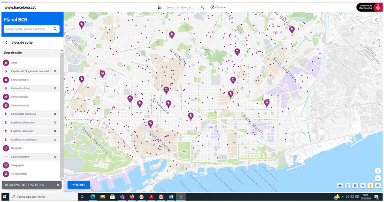
Screenshot of the Barcelona Map of Religious Centers (https://w33.bcn.cat/planolBCN)
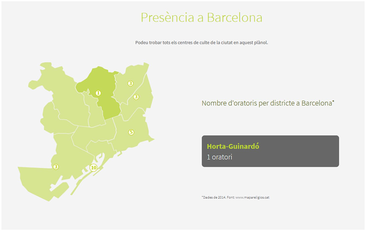
Barcelona Map Representing the Number of Places of Worship Per Religious Category and District (https://ajuntament.barcelona.cat/coneixlesreligions/islam/#on)
Hamburg: “Religious Places of Learning” and Legal-Pedagogic Politics
In contrast to the religious maps in Barcelona, the city of Hamburg produced a map of different places of worship for explicitly didactic purposes. The interactive map (see LI Hamburg, 2020) is entitled the title “Religious Places of Learning in Hamburg” (Religiöse Lernorte in Hamburg). The map has no additional features to the Google Maps tool it is based on and is hosted by the Landesinstitut Hamburg, which is part of the Department for Education and Vocational Training (Behörde für Schul-und Berufsbildung). Since Hamburg is one of the three city-states in Germany, in addition to conventional responsibilities of a municipal government, Hamburg autonomously manages its relations to religious groups and has major decision-making powers in the fields of education and culture. While the 1919 Weimar Constitution introduced a significant degree of separation between church and state, particularly the Catholic Church and the Protestant Lutheran Churches and to a lesser extend Judaism and some other groups, enjoy a series of privileges and significant state support. These are legally established through bilateral treaties between religious groups and the different states.
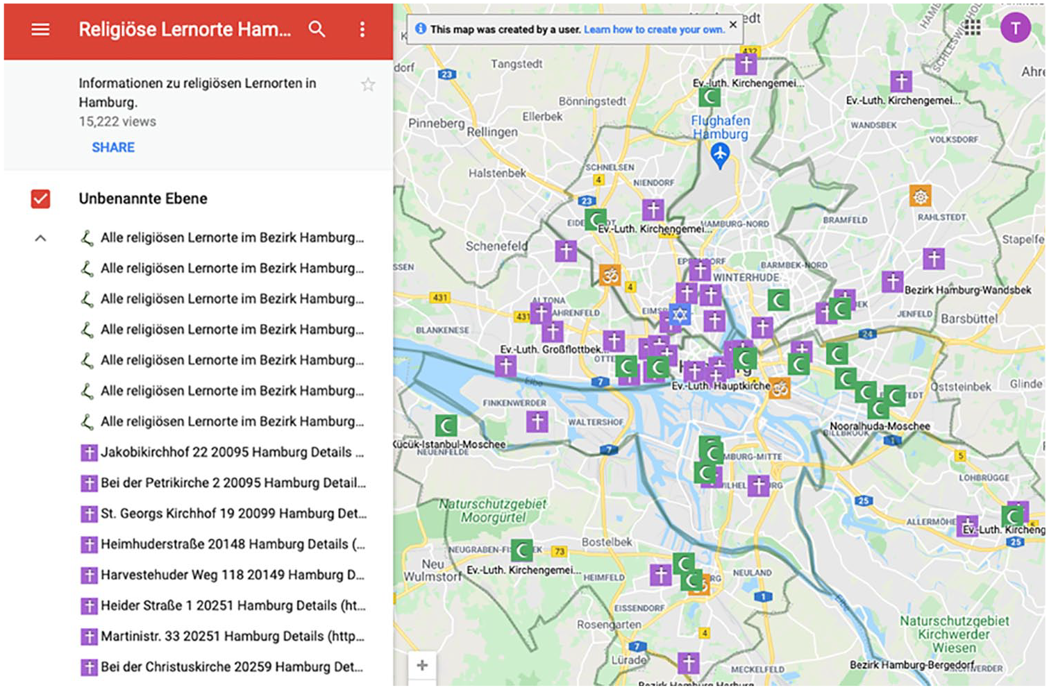
Screenshot of the Hamburg Map (https://li.hamburg.de/religioese-lernorte-hamburg/)
The origin of the Hamburg religious map can be traced back to the discussions in the run-up to the introduction of the new primary and secondary school curricula for religion published in 2011. The new curriculum stipulates that “a visit to one Christian church and one non-Christian holy space, e.g., synagogue, mosque or temple, is obligatory” (Freie und Hansestadt Hamburg, 2011). This newly introduced legal obligation created the need for places of worship that were considered suitable to be visited and where capable personnel would be able to conduct a tour of the building. In response, the Nordelbian Evangelical-Lutheran Church, which was until then responsible for the content of religion as a school subject, in cooperation with the Department for Education and Vocational Training, decided that a map would be a helpful orientation guide, particularly for non-Christian institutions.
Remarkably, the technical elaboration of the map was financed by the Hamburg-based non-denominational Christian organization “Andere Zeiten” (Other Times). It was produced in cooperation by the Evangelical-Lutheran Church and the City of Hamburg, the latter being now responsible for its maintenance. The data on which the map is based are heavily influenced by historical patterns of interaction between the City of Hamburg and different religious communities. As one of the first states in Germany, Hamburg established official treaties not only with the Evangelical-Lutheran Church (2005), the Roman Catholic Church (2006), and the Jewish community (2007) but also with three major Muslim groups and the Alevi community (2012). As part of the official treaties, each of these groups is allowed to participate in the instruction of religion in state schools. For this purpose, they maintain a close collaboration with the city administration. This also explains why it was the city government that directly gathered the information on places of worship from the Christian, Jewish, Muslim, and Alevi groups. In contrast, information on Buddhist and Hindu temples was gathered by a non-state interreligious working group set up in collaboration with the University of Hamburg called “Subject Group Religious Instruction” (Fachteam Religionsunterricht). This explains why the total of 67 places of worship on the map are divided into the following six categories: Church (39), mosque (23), synagogue (1), Buddhist temple (1), Hindu temple (3), Cem house (Cem-Haus, Alevi place of worship, 0).
The importance of this legal connection becomes even more evident when considering the fact that for Cem houses, despite being listed in the legend, there is not a single entry on the map itself. The website claims that the “religious-pedagogical opening (Erschließung)” of the Cem houses is still in progress. Another surprising feature of the map is that despite the fact that there are roughly two to three times as many Lutherans as Catholics in Hamburg, there are 38 Evangelical-Lutheran churches on the map, but only one Catholic church, St. Mary’s Cathedral. The Catholic Church decided that all school classes should visit the main cathedral to provide the best didactic experience, and they decided not to show any of the other approximately 40 Catholic churches on the map. Other Christian churches, which have several congregations in Hamburg, such as Jehovah’s Witnesses, the New Apostolic Church and Orthodox churches, as well as humanist organizations, are completely absent from the map. In sum, the Hamburg religious map was created for the didactic purposes of schools, in close cooperation with the majoritarian Christian church and including only those groups it was formally cooperating with in the field of religious education, with the addition of Buddhists and Hindus.
Amsterdam: Visualizing Secularization and Diversification
The mapping of religious buildings in Amsterdam consists of two elements, which run more or less parallel to one another. On one hand, an in-depth report entitled “Religie in Amsterdam: Gelovigen en plaatsen van samenkomst” (Religion in Amsterdam: Believers and places of gathering) was published in 2014; on the other hand, there is an interactive and bilingual (English-Dutch) map called “Places of religious meetings” (Locaties voor religieuze samenkomsten). These two elements were created by the Bureau Onderzoek en Statistik (O+S), an agency from the City of Amsterdam, which conducts independent research for the municipality.
The “Religion in Amsterdam” report consists of a detailed study conducted in 2014 at the initiative of an O+S researcher and leader of the project and as a response to the requests for information made by citizens. Unlike research in other policy areas, such as urban poverty, the research report on religion was not the result of a political mandate issued by the municipality. The overall narrative of the report is one of the de-churching and diversification of the Netherlands, and Amsterdam more specifically. These two processes, intensified since the decade of the 1960s, were preceded by a period of institutionalized religious-secular pluralism, known as pillarization. Developed and established during the 18th and specially the 19th centuries and formalized in the so-called 1917 “pacification” of liberals and confessionals, this system organized Dutch society along well-defined and separated religious and secular pillars (Dekker & Ester, 1996; Sturm et al., 1998).
Drawing on data from the Central Bureau Statistik and the Data Archiving and Network Services, the report shows the declining trend in the number of believers since the late 19th century and the diversification of the urban religious landscape. The report presents data about the proportion of believers of each tradition and the places of religious gathering. With regard to the individual believers, the classification includes Islam, Roman Catholicism, general Christianity, Protestantism, Reformed Church in the Netherlands, Hinduism, Lutheran Church, Buddhism, Dutch Reformed Church, Jehovah’s Witnesses, Humanism, Judaism, and others.
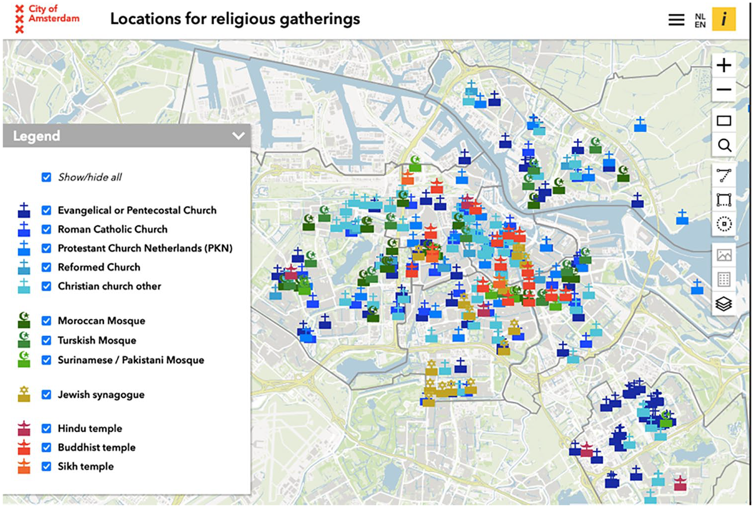
Screenshot of the Amsterdam Map (English Version) (https://maps.amsterdam.nl/religie/?LANG=en)
The starting point for the creation of the “Locations for religious meetings” map was the 2010 map of non-residential functions of buildings of the Spatial Planning Department of the Municipality of Amsterdam. The O+S researchers controlled the map of non-residential functions of buildings in various ways to verify the accuracy of the data concerning places of worship. They did so by contacting the groups located at these sites, controlling the buildings themselves by walking around, and looking for updated information on the internet. In addition, they drew on data from an investigation conducted at the University of Amsterdam and published as a CD-rom in 2002 to complement the information. The online map is updated based on changes in the map of non-residential functions but the research report on religion in Amsterdam was a one-off study and has not been updated since 2014. Therefore, the number of locations in the interactive map differs from that of the 2014 report. The fact that there is a map of locations of religious meeting in Amsterdam does not seem to be very special, as the Maps Amsterdam service “maps everything, yes, we map out everything” (personal interview with O+S researcher), from solar panels to trees, and from public toilets to sidewalk width.
The Amsterdam map, which from the outset did not attempt to be exhaustive, classifies the buildings in the following categories: Evangelical and Pentecostal church, Roman Catholic church, Protestant Church of the Netherlands (PKN), Reformed church, Other Christian church, Moroccan mosque, Turkish mosque, Surinamese/Pakistani mosque, Jewish synagogue, Hindu temple, Buddhist temple, and Sikh temple. According to the main researcher responsible for the map, the use of these categories results from different decisions. On one hand, there was a pragmatic logic: the number of categories was not intended to be so comprehensive so that an endless division of groups would render the legend on the map illegible and therefore no longer useful. On the other hand, the research team drew on what they perceived to be “standard” categories of common use as well as on the self-identification by the members of the places. This clearly reproduces an understanding of religious diversity inspired by the so-called “world religions” model. Interestingly, in Amsterdam, ethnic categories used in multicultural policies were transported into the religious map, which incorporates an ethnic/national category to the classification of mosques, something which does not occur in the cases of Barcelona and Hamburg.
Discussion and Conclusion
The comparative analysis of the three cases reveals the existence of three different logics behind the production of these maps, namely showcasing diversity, regimes of governing religion, and the making of boundaries.
Showcasing and Teaching Diversity
The three religious maps form an integral part of the efforts to give a material dimension to the “diversity paradigm” (Faist, 2009). The three cities are among the most important naval hubs in Europe and have long histories of trade and imperialism. The religious traditions and practices migrants brought to the port cities and adapted to the new context, such as the Buddhism of Vietnamese “boat people” in Hamburg, are now considered part of the city’s self-identity. Maps, as the symbolic representation of the materiality of places of worship, instantiate diversity, a category and a religious reality that is otherwise abstract and disembedded. The exercise of mapping diversity has the potential to flatten hierarchies and historical power struggles by depicting different places of religious practice as ontologically equal. Religious maps, where the backyard mosque and the cathedral are both represented by one small symbol, are a visual materialization that is considered suitable to performatively instantiate the equality that the diversity narrative seeks to promote. Mapping thus, forms an important element of a politics of recognition, as the case of Barcelona demonstrates.
However, the seemingly unproblematic juxtaposition of places of worship glosses over processes such as the struggles of minority communities to acquire land and building permissions and the strong preferential treatment of some groups over others. The Hamburg map is particularly instructive in that regard. While the website claims to “mirror . . . religious diversity” (LI Hamburg, 2020) in the city, it only depicts religions that form part of the privileged few that either have established a legal relationship with the state (some Christian, Muslim, Jewish, and Alevi groups), or are considered of importance by virtue of being “world religions” (Buddhism and Hinduism). Similarly, in the Amsterdam map the underlying classification is that of the world religions model—partly extended with some specificities of the diverse Protestant field in the country—with the particularity of the ethnic label attached to mosques. In Barcelona, despite the clear intention to recognize diversity, minority groups—and especially Muslims—face acute “bureaucratic” difficulties and neighbors’ opposition when building worship places (Astor, 2012).
The exercise of mapping opens up and is usually bound to a pedagogical impulse. The case of Hamburg is illustrative. The main driver behind the creation of the religious map was to facilitate school children’s visits to non-Christian places of worship and to tell teachers which places are considered “adequate” for that purpose. Also, the Barcelona and the Amsterdam administrations clearly communicate the maps as part of their project not only to recognize the social fact of diversity but also to shape the city according to diversity as a normative model. Particularly in highly secularized and diversified settings such as Amsterdam, religious maps can be understood as the symbol for a politics of recognition that transcends traditional patterns such as Dutch (de-)pillarization.
Significantly, in addition to municipal administrations, churches also act as “diversity entrepreneurs.” As the case of the Lutheran church in Hamburg demonstrates, Christianity-led initiatives that produce religious maps can enable churches to maintain considerable influence in the teaching and representation of religion in a particular urban setting. Especially at a moment when suspicion around certain places of worship has grown due to Islamophobia and the war on terror, implicitly or explicitly curated maps provide much sought-after orientation. They translate the pluriverse of transcendental orientations into the manageable virtual reality of a map. Thereby, it turns the daunting complexity of potentially dangerous religions and foreign organizations into an element in a map that can be accessed, bookmarked, and “liked” just like the favorite coffee shop or secondhand store.
Visual(izing) Regimes of Governing Religion: Legibility, Surveillance, and Governability
The three maps were produced in a context where religion is gaining global relevance as an identity marker and religious categories are increasingly considered for governance purposes (Burchardt, 2017a). Around the turn of the millennium, fueled by 9/11, local and national governments across Europe started to set up a series of dialogue and cooperation initiatives that engage religions (Martínez-Ariño, 2019). Many of these initiatives primarily focused on Islam in a climate in which religion per se, and Islam in particular, had been increasingly securitized (Müller, 2017). The main implicit question behind these maps, thus, is that of the place of Islam in Europe in general and in each national and local context in particular, and of the institutional manifestation of Muslim life in certain European cities. 2 In Hamburg, for instance, the perceived need to integrate Muslims into the teaching of religion in state schools led to the establishment of a legal cooperation framework that provided the city administration with a formal channel of communication and a leverage on Muslim organization to correctly self-report information on the different mosques. The legal cooperation framework served as an administrative mechanism for excluding places of worship where security-related concerns existed from the highly selective map of religious places of learning. However, not only the fear of extremism and jihadist terrorism fosters a politics of suspicion against religious minorities but also political agendas against new religious movements (Barker, 2011) have contributed to spread the idea that a watchful eye should be kept over religions.
As thematic maps, religious maps make the highly complex processes of religious diversification and (de)secularization legible to the eyes of the state, and citizenry at large, while simultaneously contribute to transform these same processes. The narrative behind the maps depicting spaces of worship is built around the idea that the multi-layered processes of religious change can be understood and controlled through the materiality of the place of religious practice. The maps, thus, turn sprawling, contradicting, often digital, trans-local assemblages of religion into discrete categories such as “Surinamese/Pakistani mosque” or “Cem-houses.” These categories are epistemological-political artifacts which can be recognized by the biopolitical gaze of the state as distinct population units. For instance, the attribution of ethnicity, while necessarily reductionist, is a category frequently used in bureaucratic procedures employed by state actors, instead of denominational or religious differences as a marker to distinguish the units on the map. As a result, these units can be dealt with through the conventional mechanisms of the state apparatus; they can be consulted, visited, surveilled, questioned, required to self-report on the communities they serve, asked to make themselves transparent, and urged to participate in the educational project of the state, to teach certain kinds of diversity. Religious maps, these cases show, are not only indicative of the exigencies of securitized governmentality, but in themselves can turn into the instruments through which state actors, and the population at large, can more easily monitor certain populations.
The Making of Categories: Boundaries, Exclusion, and Inclusion
To map places of religious practice allows societies to instantiate and represent religious diversity, a category and a reality that might, otherwise, seem abstract and disembedded. At the same time, the exercise of mapping also produces and reproduces a certain conception of religion and of religious groups. To map a reality means necessarily to define such a reality and the act of defining religion is, according to James Beckford (1999), a deeply political act that has concrete political consequences for religious groups.
Religious maps are predicated on the assumption that “religion” is primarily located in places of worship, and that it is possible to account for the changing relevance of a particular religious group in a city by counting the number of places of worship they manage. The implicit idea is that religious beliefs or affiliations are always expressed through the believers’ participation in the activities occurring in designated religious buildings, which risks prioritizing institutionalized, elite, and male forms of religion (Silvestri, 2011). The reason for this is that religious buildings are often dominated by male religious experts and elites (priests, imams, rabbis, etc.) and that female and grassroots participation is often stronger in informal spatial settings (see Müller, 2021, p. 8). The analysis of the categories used on the maps themselves and in the conversations that produced the maps, also shows that maps privilege “world religions” and that certain religious groups are marginalized or excluded (e.g., Scientology or Paganism).
In abstract terms, the concept of diversity is considered to encompass all possible forms of religious life. However, the analysis of these urban religious maps shows that the rhetoric of diversity conceals processes of over-representation of certain groups and exclusions of others. Historical trajectories and local constellations of power filter the production of categories and help to explain divergences among maps. The ethnic labels assigned to mosques in the Amsterdam map, reflecting the history of multicultural policies addressed to minority groups, is a paradigmatic example of this. Finally, there are an increasing number of groups that might be classified at the intersection of several categories such as religion, spirituality, therapy, or leisure (e.g., Yoga centers or Humanist organizations). Religious maps created by local authorities tend to omit these groups, a choice which reflects and reproduces more static, traditional, and fixed approaches to the religious landscape.
Because maps are instrumental in producing silences, exclusions, and inclusions, as this contribution has demonstrated, they can be used as helpful empirical points of entry to investigate the rationalities and contradictions inherent in urban regimes of religious diversity and vernacular practices of secularism. At the same time, maps are also productive of new social and spatial identities, and once produced can take a life on their own. For this reason, critically focusing one’s attention on the ways maps are conceived, produced, and circulated offers a distinctive lens through which to explore entanglements of knowledge, media and power in the contemporary making of social, political, cultural, and religious landscapes.
Footnotes
Acknowledgements
The authors thank Gerbrand Allon Makkinga for his assistance with the analysis of the Amsterdam case, Anna Körs for advice on the Hamburg case, Maria Forteza for her advice on the Barcelona case and Paul Bramadat for very insightful comments on an earlier version of this paper.
Author’s note
Tobias Müller is now affiliated to The New Institute, Hamburg, Germany and Yale University, USA.
Declaration of Conflicting Interests
The author(s) declared no potential conflicts of interest with respect to the research, authorship, and/or publication of this article.
Funding
The author(s) received no financial support for the research, authorship, and/or publication of this article.