
Abstract
We provide original research on planning for sea level rise (SLR) in the southeastern United States. Our analysis of 85 coastal counties finds that most are in the early stages, having recognized SLR as a general threat to their coastal communities. However, relatively few evidence comprehensive analysis of risk across their portfolio of infrastructure assets and service areas. Using a staged planning model, we find that strong information gathering contributes to greater breadth when considering adaptive measures. Ultimately, integration of risk management and comprehensive planning can help create adaptive pathways by identifying short-term, low-regret actions while preserving options for an uncertain future.
Introduction
For coastal communities, the potential long-term impacts of sea level rise, such as loss of habitable land, enhanced coastal flooding, and saltwater intrusion (Intergovernmental Panel on Climate Change, 2019) present significant planning challenges. Such impacts to the physical environment could lead to migration from low-lying coastal areas, loss of tax revenue, greater damages from extreme weather events, and new infrastructure needs (Lincke & Hinkel, 2021; Ranger et al., 2013). Although planning for SLR is characterized by high levels of uncertainty that complicate long-term decision-making (Haasnoot et al., 2019; Hinkel et al., 2019), current impacts of SLR, such as high-tide (“sunny-day”) flooding, demonstrate that disruptions are intensifying and becoming more visible to the general public (Sweet et al., 2022).
Research on planning for SLR provides insight into the spectrum of adaptation responses that governments may pursue, such as protection with hard and soft engineering measures, accommodation of the built environment, and managed retreat (Hino et al., 2017; Intergovernmental Panel on Climate Change, 2022; Siders, 2019). Furthermore, such research illuminates the unique political and technical challenges that local communities encounter. Political challenges include SLR becoming a policy priority in the face of urgent competing local needs (Yusuf et al., 2016), whereas technical ones involve complex vulnerability assessments to pinpoint specific risks (Allen et al., 2019; Hinkel et al., 2019; Parkinson & McCue, 2011). This research comprehensively reviews potential benefits of adaption and challenges faced by metropolitan areas via case work, but there is a need for studies that systematically study adaptation across geo-political regions (Magnan et al., 2022).
The purpose of this study is to help fill this gap in the literature with original research on planning for SLR in the southeastern coastal United States. In the United States, local governments have taken the lead on SLR, given mixed support for adaptive climate measures at the federal and state levels, unique political environments along vast coastlines, and local government autonomy (Ford & King, 2015; Vella et al., 2016; Yusuf et al., 2016). We chose to study the southeast to provide an inventory of practices in an area that already experiences disruptive impacts from SLR and one that features a diverse range of political and physical environments. Specifically, our study area covers each of the coastal counties in North Carolina, South Carolina, Georgia, Florida, Alabama, Mississippi, and Louisiana (N = 85). We extracted data from the various planning documents of these counties to identify focus areas, risk types, and adaptive risk reduction tactics, placing the tactics within stages of a planning model. To help validate our findings from the government documents and understand local context, we conducted a structured media review.
Overall, results demonstrate that planning for SLR has arrived along the southeastern shore of the United States, but in an eclectic fashion. Our analysis of 85 counties indicates that most have formally recognized SLR as a general risk, but fewer have been specific in defining how it could impact different services areas and infrastructure assets. Furthermore, in the context of our planning model, we observe that strong information gathering contributes to more completely documenting risks when considering adaptive measures. Ultimately, integration of risk management and comprehensive planning can help achieve an important objective of adaptive governance - avoiding vague conceptions of climate risks and developing tractable solutions to address them through adaptive pathways.
We begin with a brief literature review on planning for SLR and then present the planning model used to conduct our analysis. The methods and data are then described. We next provide results on the scope of risk management practices and place them within our planning model. We conclude by situating our findings within public management research, discussing our contributions, and highlighting key areas of future research.
Planning for Sea Level Rise
Although local governments are accustomed to planning in the face of uncertainty, SLR introduces significant challenges to traditional routines. At the summary level, the uncertainty surrounding long-term SLR projections coupled with the number of service areas impacted, each of which have unique tolerances for uncertainty, complicates the development, prioritization, and commitment to adaptive measures (Haasnoot et al., 2019; Hinkel et al., 2019; Kopp et al., 2019). Critical infrastructure, including transportation networks, power generation, and water management systems, are intended to provide services for several decades. However, beyond 2050 and heading to 2100, SLR scenarios are characterized by high levels of uncertainty (Sweet et al., 2022). Therefore, “wait and see” approaches introduce the risk for untimely adaptations and disruptive retrofitting, whereas more aggressive ones can lead to costly overinvestment (Haasnoot et al., 2019).
To cope with this uncertainty, a framework for decision making, known as Dynamic Adaptive Policy Pathways, has been developed and applied to SLR planning (Haasnoot et al., 2013, 2019). Adaptation pathways offer an approach for conceptualizing the optimal sequence of commitments as threats are better understood, such as identifying low-regret, short-term actions while preserving options for an uncertain future. For example, the Thames Estuary 2100 Project has been recognized for utilizing adaptation pathways in planning for improvements to London’s flood management system (Ranger et al., 2013). The project preserved options by incorporating structural flexibility into the design, allowing infrastructure to be enhanced in the future at minimal cost and using an iterative risk management approach to sequence actions as uncertainty reduces alongside discovery. This innovation and case help illustrate the potential benefits of adopting cutting-edge techniques. However, local governments may lack the managerial capacity to perform such complex analysis and encounter political barriers to adaptation (Hinkel et al., 2019; Moser & Ekstrom, 2010; Yusuf et al., 2016).
Research on planning for SLR offers rich cases of metropolitan areas that provide valuable context on barriers to adaptation, community outreach, collaboration, and planning practices (Abel et al., 2011; Hallegatte et al., 2011; John III & Yusuf, 2019; Lubell & Robbins, 2022; Vella et al., 2016). Regarding barriers to adaptation, challenges have been evidenced at different stages, ranging from issue framing to implementation (John III & Yusuf, 2019), illustrating that beliefs about climate change impact public support and, even with public support, developing tractable solutions is complex. Given these technical complexities and uneven support, local governments may collaborate for the purposes of knowledge exchange and lobbying, respectively (Vella et al., 2016). For example, the South Florida Regional Climate Compact provides a platform for multiple counties to gather information, disseminate knowledge, and lobby the state legislature and federal government for support.
In sum, studies of metropolitan areas provide depth and offer valuable frameworks for planning. However, fewer studies have been conducted beyond metropolitan areas featuring numerous local governments, especially ones that take detailed inventories of adaptive management practices (Butler et al., 2021; Hines et al., 2022; Hino et al., 2017; Siders & Keenan, 2020). Our current study adds to this literature by examining 85 coastal counties in the southeastern United States, stretching from North Carolina to Louisiana. In the following section, we describe the conceptual framework used for our analysis.
Adaptive Risk Management Framework
Our adaptive risk management framework intertwines concepts from adaptive governance (Ford & King, 2015; Moser & Ekstrom, 2010) and capital planning (Srithongrung et al., 2019). The rationale for blending these literatures is to combine their strengths and avoid the limitations of using either in isolation (Hines et al., 2022). Specifically, adaptive governance best illustrates the politics of climate change and SLR, evaluation of climate risks, and barriers to adaptation. However, its focus is not on the mechanics of existing planning and budgeting routines in local governments, which are the key platforms for strategic direction, path choice, and execution. Of course, this is the general scope of capital planning and budgeting, but it must be on the receiving end of innovative climate research.
To conduct our analysis, we use an adaptive risk management framework recently applied to Floridian coastal counties (Hines et al., 2022). The framework outlines a normative planning process with several stages, beginning with recognition of SLR as a general risk (See Figure 1). Ideally, strong information gathering, such as formal vulnerability analysis, precedes the development and prioritization of options to create adaptive pathways. As described in SLR research, formal vulnerability analysis involves projections of local SLR, simulations of extreme weather events, and Geographic Information Systems (GIS) with details on the characteristics of local infrastructure assets (Allen et al., 2019; Parkinson & McCue, 2011). Adaptive Risk Management Framework. Legend: Italicized entries draw from the adaptive governance/policy process literature and bolded entries draw from the 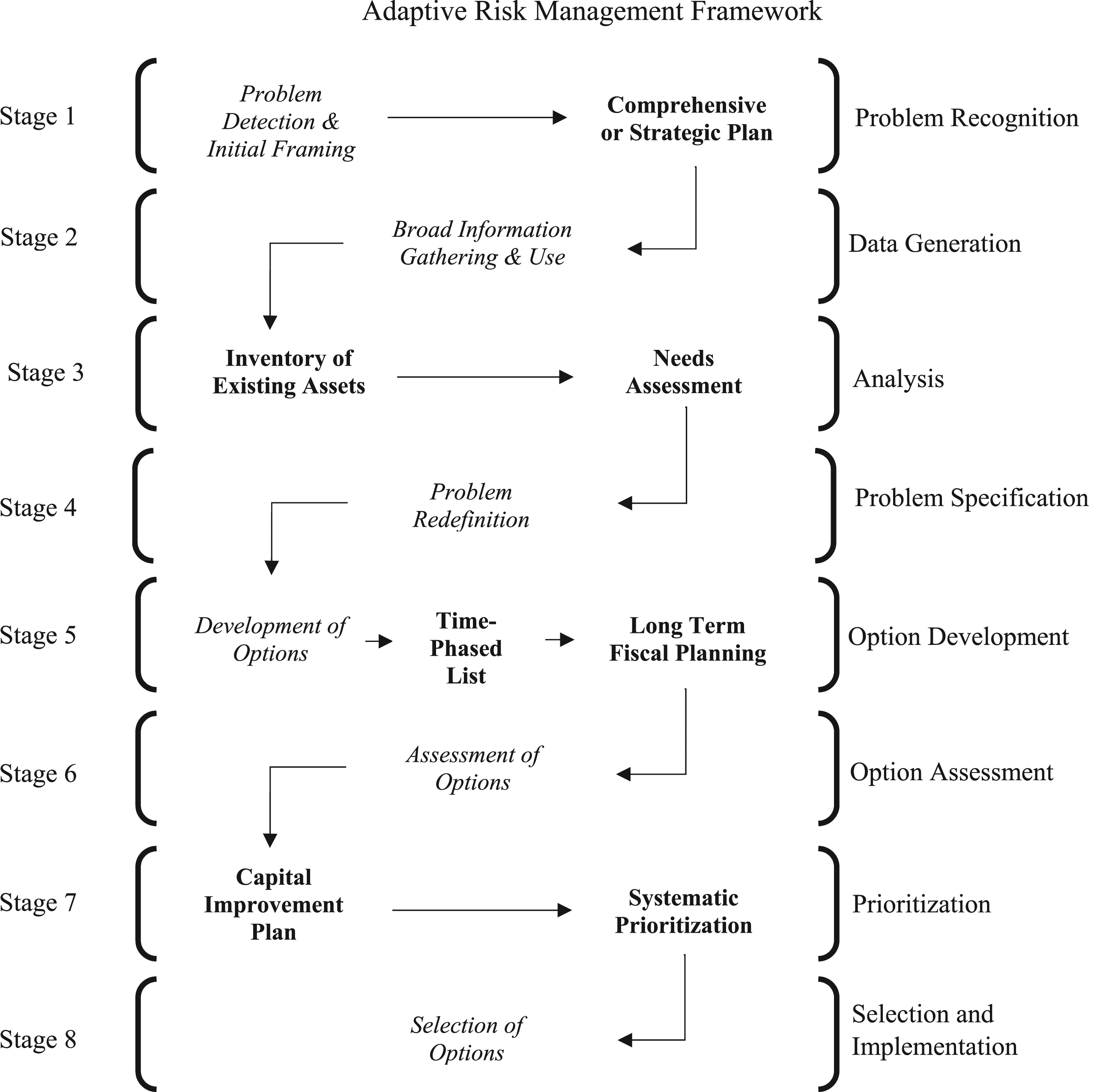
Of course, we recognize that it is much easier for normative frameworks to be constructed than implemented. Nevertheless, the framework outlines the essential components of capital planning and budgeting where climate information could be included to impact decision making and is therefore suitable for descriptive and comparative purposes. Next, we explain the methods and data used for our analysis.
Methods and Data
We employed a multi-method design, involving review of comprehensive plans, county commission meeting minutes, land-use plans, and annual financial reports, coupled with a structured media review. Our study area includes the 85 coastal counties in North Carolina, South Carolina, Georgia, Florida, Alabama, Mississippi, and Louisiana. 1 Code was written to identify keywords within each document for the 85 coastal counties, and we extracted a total of 512 “policy instances”, or substantive references to SLR. 2 To classify the policy instances, we first developed a categorization scheme to describe focus areas, risk types, and risk reduction tactics. A grounded theory approach was utilized to inductively determine the items to include within each said category, for example the risk types, by using a constant comparison method to reach a point of theoretical saturation (Glaser & Strauss, 1967).
We then assigned each of the 512 policy instances to the stages of our planning model. In classifying the policy instances, each of the three authors were present in joint coding meetings to reach consensus. To provide additional context to policies evidenced from governmental documents and attempt to validate our findings, we performed a systematic media review. Specifically, we used the same search terms listed in the footnote to identify local news articles and documentaries to create a local news database, with approximately 200 items. In coding the observations for each county per the governmental documents, we used the media review to better understand the position of each and its standing in relation to others. For example, our document review makes clear that Monroe, Miami-Dade, and Broward Counties are leaders in adaptive risk management in the state of Florida. Furthermore, the media review supports this point with accounts from local journalists being critical of other Floridian counties for not making as much progress in relation to said counties.
Charleston County’s Stormwater Policy Development.
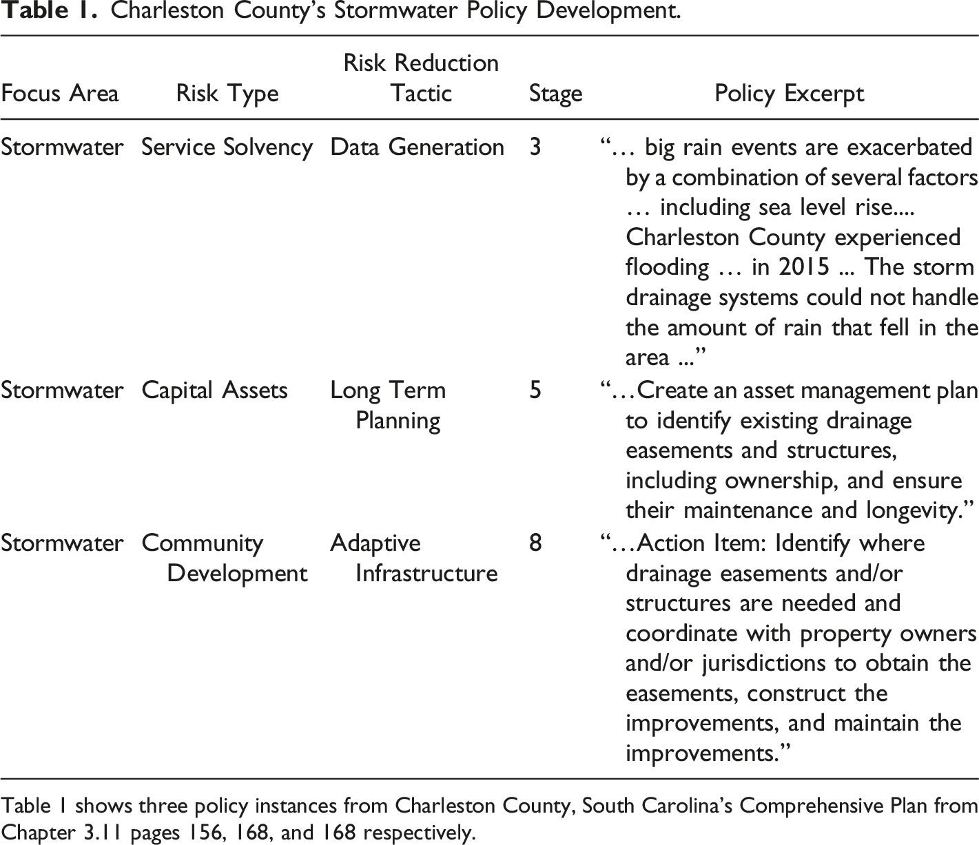
Table 1 shows three policy instances from Charleston County, South Carolina’s Comprehensive Plan from Chapter 3.11 pages 156, 168, and 168 respectively.
Finally, in coding our observations, we learned that counties with stronger information gathering activities in the early stages of our model tended to plan for SLR across a greater range of service areas. Therefore, we also evaluate policy in terms of breadth, meaning that we analyze the number of different focus areas addressed, risk-types considered, tactics deployed and relate these to the status of their information gathering activities. In the following section, we first provide results on the scope of risk management practices using our categorization scheme. Practices are placed into the framework, and we then relate information gathering to breadth.
Results
How are Southeastern Coastal Counties Planning for SLR?
Summary Policy Counts for All Counties.
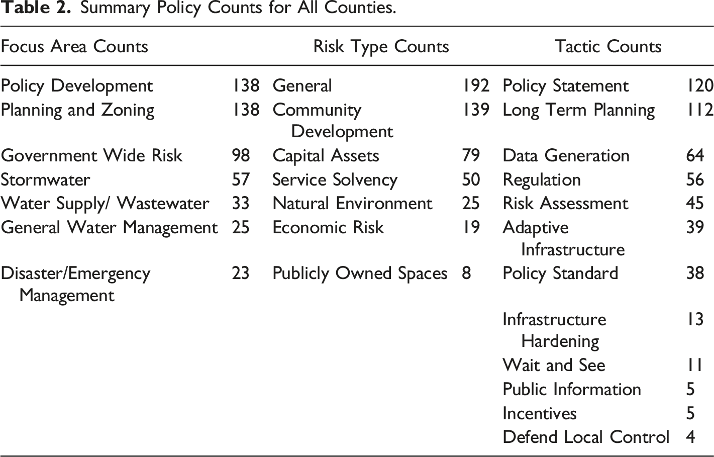
As for the specific risk types, Table 2 indicates that they are broad, including the general development of coastal communities, vulnerabilities to capital assets, challenges with delivering essential services, and general risks associated with potential loss of property, industry, and tax revenue. Finally, we found that the tactics employed to reduce exposure to said threats are split between early approaches and more specific maneuvers. By early approaches, we refer to tactics that are predecessors to having specific information, such as the issuance of policy statements that long-term planning must account for SLR via data-driven risk assessments. Once these early tactics are employed, more specific ones emerge, such as regulation on land-use and building standards along with investments in adaptive infrastructure.
At What Stage are Coastal Counties in Planning for SLR?
Figure 2 shows the maximum stage reached for each county in our planning model. Approximately 60% of counties have formally recognized SLR in their planning documents (Stage 1 or higher). As the shading indicates, many have done more than simply recognize SLR as a risk and have progressed to later stages of the model. Specifically, 40% of the counties have developed options for dealing with SLR (stage 5 or higher). As those familiar with SLR in the United States may anticipate, a few counties in South Florida emerge as leaders. Specifically, Monroe (the Florida Keys), Miami-Dade, and Broward Counties. For Monroe, the story is simple – the southernmost county in the United States is a set of low-lying islands connected by transportation networks that traverse a narrow land mass. Given its general status as an archipelago and specific characteristics, the area is likely to experience substantial impacts from rising seas and could greatly benefit from adaptive efforts (Magnan et al., 2022). Therefore, significant attention has been placed on the long-run sustainability of the Florida Keys and its tourism driven economy. Maximum stage in adaptive risk management framework attained.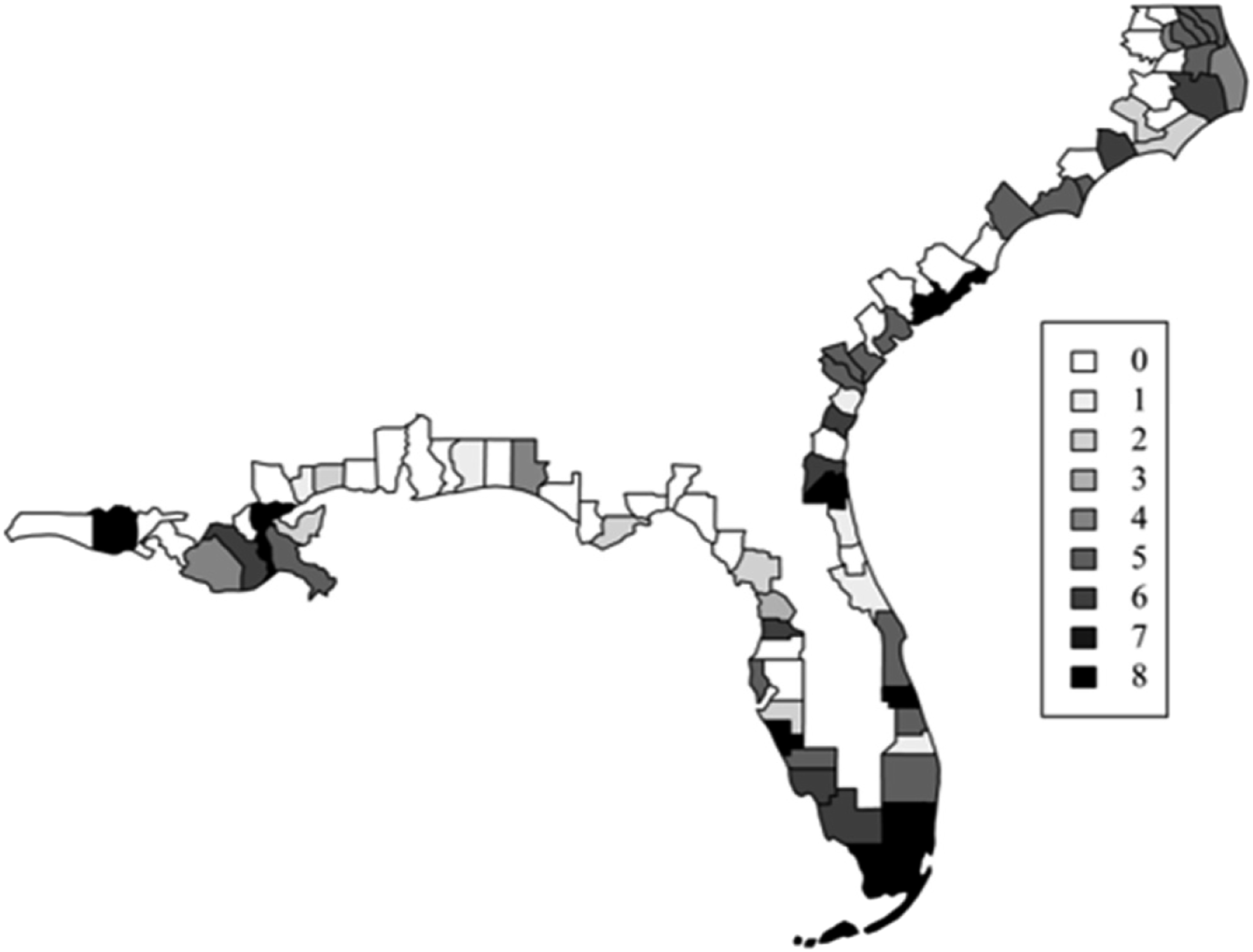
It is apparent that SLR planning has arrived in the New Orleans area. Specifically, in reviewing documents from the consolidated city-parish of New Orleans, we find that vulnerability analysis took place prior to Hurricane Katrina in 2005, with very sophisticated work occurring afterwards. This early attention to SLR can be attributed to unique characteristics of the physical environment, specifically because it resides in a subsiding delta, contributing to higher rates of relative SLR (Sweet et al., 2022). The local government has thoroughly defined their risks based on data-driven assessments, with consideration given to wetlands restoration, building elevations, management of stormwater, and integration of levees into the landscape.
However, the same cannot be said for many counties of east of New Orleans until the more populated Tampa Bay Metropolitan area on the Gulf Coast of Florida. In the Tampa Bay area, local governments have been pressured to catch-up to their counterparts in South Florida (Hines et al., 2022). Moving up the Atlantic coast, there is an eclectic mix of progress. For the most part, heavily populated areas tend to be further along, and many counties evidence strong information gathering and community engagement preceding their option development. At the same time, some counties remain in a “wait and see” mode. For example, Dare County, North Carolina, last updated their land use plan in 2009, pointing to the uncertainty of long-term SLR projections, making them more inclined to gather additional information before committing to major changes: Due to the lack of consensus on the issue, the Planning Board felt it was best to include a policy that recognized the continued debate and reserve judgment on any initiatives that may be the result of this continued debate (Dare County, 2009, p. 184).
In addition to determining the stage that each county reached, we identified the number of specific risk types considered when developing options. Figure 3 shows the breadth of specific risk types for each county, and indicates that relatively few have multiple, specific risks documented in their plans. Thus, although many counties have progressed to later stages of the model by making general statements about the need to consider SLR, fewer have been precise by pinpointing specific risks to community development, infrastructure asset management, service delivery, and tax revenue. Count of specific risk types addressed by stage 5 of higher policies.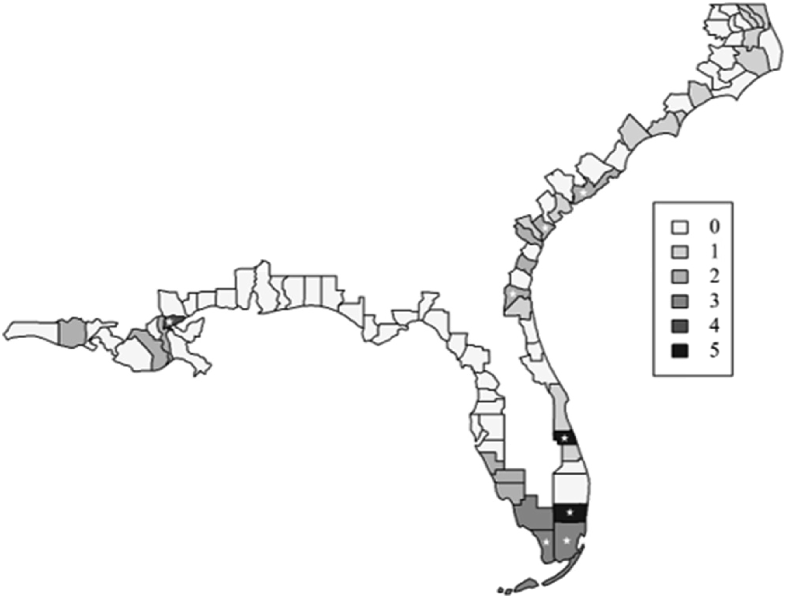
Figure 3 also marks which governments have documented their information gathering activities (stages 2 and 3). As the map indicates, areas with stars tend to be shaded darker. Therefore, counties that step through early stages of our model seem to have greater breadth in their risk management practices. Likewise, those that skip early stages appear to have less breadth. Without engaging in robust information gathering in the early stages, most counties are unable to move beyond vague conceptions of threats and on to the development of specific options.
Still, after conducting our analysis, we felt the maps did not fully capture the differences observed in our study. Therefore, we added a quantitative test to complement our qualitative analysis. Specifically, we wanted to quantify differences between “steppers” and “skippers”. By steppers, we refer to counties that have moved sequentially through the model- steppers have documented their information gathering activities (stage 2 and 3) to inform option development (stage 5). In contrast, skippers are those that have not documented information gathering but have developed options.
Do steppers evidence greater breadth in their risk management practices than skippers? To answer this question, we used a couple approaches for comparing groups, such as a simple comparison of means (t test) and a robust Fligner-Policello (FP) test (Fligner & Policello, 1981; Fong & Huang, 2019; Hollander et al., 2013). We chose to use the FP test because it does not make restrictive assumptions that the simple comparison of means does, such as normal distribution and equal variances, which would not fit with our data. Results indicate that steppers are significantly more likely to have addressed a greater number of risk types than skippers (p < 0.001). Furthermore, we observed similar patterns when considering focus areas and risk reduction tactics. Again, we find that steppers are significantly more likely to document a greater number of focus areas and risk reduction tactics than skippers (p < 0.001). 3
In sum, steppers indicate greater breadth in their risk management practices than skippers at each level of our policy categorization scheme. In the following section, we elaborate on summary results with further illustration of steppers and place our findings within the broader literature.
Discussion
Our study contributes knowledge to the fields of planning, risk management, coastal resilience, and budgeting. We provide a wide inventory of SLR planning practices in southeastern U.S. coastal counties, describing risk management practices that promote coastal resiliency within the context of capital budgeting.
Previous research on SLR planning has emphasized metropolitan areas via case work, with relatively few studies examining numerous governments and multiple service areas. These studies have been valuable for understanding the nuances of planning for SLR in localized environments. With this research, we aimed to complement the depth of knowledge from existing research with breadth, both in terms of the number of governments studied and service areas considered. Furthermore, our findings on the relationship between information gathering activities and breadth of risk management practices are helpful for illustrating the technical challenges of planning for SLR.
Our study shows that planning for SLR has been a formal concern for most coastal county governments in the southeastern United States. Yet, the extent to which practices are documented varies widely, with approximately 60% formally recognizing SLR as a threat to their communities. By now, most communities are aware of the integrated nature of these risks, either by exposure to extreme weather events or vulnerability analysis. Indeed, local citizens, officials, and journalists are acutely aware of roads that regularly flood in their communities, with impacts ranging from minor disruptions to matters of life and death. For example, a local official in Beaufort County, South Carolina bemoans: “We’ve got the documentation…What (SLR) is doing is inundating some of my roads on regular King tides and even on some spring tides…we are getting to a point to where we are having to condemn houses because we can no longer provide emergency services to those houses” (South Carolina Educational Television, 2018).
Our normative model emphasizes the importance of robust information gathering for long-term planning, and the empirical results support our point. Counties that documented their efforts to generate and analyze data tend to address a greater number of focus areas, identify a broader spectrum of risks, and employ a greater variety of risk reduction tactics. Essentially, steppers indicate better risk management than skippers. During the course of the study, a few steppers emerged as leaders, one of them being Monroe County, Florida. Specifically, Monroe is grappling with costly road elevation to sustain a transportation network in the set of low-lying and narrow islands that comprise the Florida Keys. As the Chief Resiliency Officer of Monroe County explained: “We’ve been very active for the last decade in the Keys. We launched our Green Keys Resilience Plan back in 2016. We have been doing a lot since then because we have to get all this data gathering and modelling done before we can jump into that multi-billion-dollar implementation plan…the ultimate goal of this is to have an actual implementation plan where we can peel off projects as we get the money figured out” (South Florida Regional Climate Compact, 2020).
Another South Florida county, Broward, emerged as a leading stepper in our governmental document review. To begin, Broward County had the largest number of policy instances, accounting for 85 of the 512 instances. Furthermore, Broward has used advanced modelling to inform planning across a broad spectrum of service areas. Finally, Broward County was awarded the 2014 National Planning Excellence Award for Environmental Planning by the American Planning Association for their efforts to plan and adapt to climate change. Our review of Broward, and other steppers, illustrated the importance of collaboration for both knowledge acquisition and community engagement. As the Principal Planner for Broward County described: “The fact that we could get as many planners, technical experts, educators, and local and regional agencies as well as the public involved in this process made this truly a collaborative effort” (American Planning Association, 2014).
Other steppers, such as Chatham County, Georgia, home of the historic Savannah area, are earlier in their journeys, but the importance of information gathering for prioritizing adaptive measures is apparent. The Assistant Engineer of Chatham County explained to the media how the incorporation of SLR into flooding scenarios would inform their planning and decision making upon a completion of a study. “The water is ankle deep now, but once we put SLR on it is going to be knee deep, so we need to look at that as a priority…we are going to prioritize the findings and start looking at capital improvements projects to address the issue” (WSAV3, 2018).
Support for adaptive measures at the state level has evolved in our study area over the last decade. In Florida, the current Governor appointed the state’s first Chief Resiliency Officer (CRO) to prepare for the impacts of SLR and “fortify Florida’s pathway to continued prosperity”, contrasting with the previous Governor who was hesitant to recognize local impacts of climate change. In North Carolina, a political dispute emerged following the publication of a 2010 report analyzing the impacts of SLR to their coastal areas by the year 2100. Citing the uncertainty of long-term SLR projections, state politicians downplayed potential risks, opting to limit their attention to a 30-year timeframe. However, the state’s most recent SLR assessment does extend to 2100.
Our findings fit with key themes from SLR planning literature in the United States. Although planning for SLR has arrived in the southeast, it has done so in an eclectic fashion, with varying levels of leadership commitment and progress (Moser & Ekstrom, 2010; Yusuf et al., 2016). Some communities are beginning to conduct more sophisticated vulnerability assessments and adopting a systems level approach, consistent with best practices from the literature (Allen et al., 2019; Brown, 2019; Pezza & Pinto, 2019). Based on such assessments, counties have taken planning actions that square with common tactics, such as protection of water systems and transportation networks, along with consideration of storm surge barriers and seawalls, among other things (Fisk, 2019; Siders & Keenan, 2020). Furthermore, positive sentiment can be found for proactive strategies and the limitations of reactive ones are understood (Price, 2019). Finally, collaboration with citizen groups, other municipal governments, businesses, and research organizations can contribute to better planning (John III & Yusuf, 2019; Morris et al., 2019; Vella et al., 2016; Yusuf et al., 2018).
Still, findings indicate there is much room for improvement. Because many coastal counties have yet to formally embed SLR projections into their plans, it has impeded progress toward adaptive pathways. However, opportunities for organizational learning abound, both in terms of skippers learning from steppers, and steppers learning from their international counterparts. For example, the New Orleans area has worked with experts from the Netherlands, and the Charleston area has taken advantage of “Dutch Dialogues”. Ultimately, planning for SLR requires political will, and for those communities fortunate to have it, knowledge can be acquired and applied through collaboration.
Conclusion
Our study adds to the growing body of knowledge on SLR planning, with original research on southeastern U.S. coastal counties. The study region covered a range of social and physical environments, offering insight into the political and technical challenges of planning for SLR. Results indicate that most are in the early stages, having recognized SLR in their planning documents and broadly defining general risks. However, relatively few evidence the integration of risk management with long-term planning to foster adaptive pathways. Within the context of our staged model, these “steppers” show greater breadth in their risk management practices than “skippers”, both in terms of the number of risks identified and tactics used to reduce them.
We acknowledge the limitations of our study. First, our classifications capture what has been formally documented. It could be the case that some governments performed vulnerability analysis but did not document that or how it would be used. However, we emphasize the formal integration of risk and long-term planning. Second, we focus heavily on planning and not necessarily decision-making and implementation. Symbolic plans may have been crafted without commitment of resources or authorized projects might be delayed. Third, it could be case that some counties have made additional progress within the last few fiscal years since the collection of our primary data. Finally, county governments are only one piece of the complex intergovernmental structure when it comes to adapting to SLR.
Future research can build on this study. First, our study is a snapshot of planning practices at a specific point in time. Therefore, future research should be conducted to show progression, or potential backsliding, among the counties. Second, our study on coastal counties deals directly with only one layer of the intergovernmental structure, so work on other municipal governments can be done too. Next, our approach to studying the southeastern United States can be applied to other areas. Finally, our study is descriptive in nature. Future research can use some of our concepts, such as maximum stage reached and number of risk types, as dependent variables with a set of political, financial, managerial, and environmental variables used to make inferences on what factors push and pull local governments toward adaptive risk management.
Footnotes
Declaration of Conflicting Interests
The author(s) declared no potential conflicts of interest with respect to the research, authorship, and/or publication of this article.
Funding
The author(s) received no financial support for the research, authorship, and/or publication of this article.