
Abstract
The Netherlands has a history of land reclamation from the sea. They deploy a large amount of infrastructure for water management, e.g., dike rings, pumping stations, drainage canals, and almost every water body in the country is under engineered control. The Dutch consider land as a precious good that shouldn’t be spoiled and as a result, infrastructure is never abandoned, but preferably refurbished, renovated, reinforced or replaced. Over the past 30 years, the Dutch learned that water cannot only be turned and controlled with infrastructure but should also be accommodated and accepted as a guiding principle in spatial policy making. In this commentary we compare lessons from the Netherlands with Florida where engineered water control has also reached its limits. The Dutch developed a Room for the River Program to accommodate more water, a Freshwater Strategy to better utilize the underground sponge capacity, and a Spatial Adaptation Program to better adapt to weather extremes in urban areas.
Keywords
Introduction
A relevant perspective for considering the value of infrastructure when it reaches the end of its lifecycle, is the availability of space to develop new infrastructure in another place. If space is less available, there should be a stronger incentive to replace old infrastructure with new infrastructure at the same place. In dense urban areas, such as New York City, Los Angeles, or Miami, it is less likely to leave infrastructure abandoned because of much higher land prices per acre. And even outside dense urban strips, scarcity of land could be an incentive to work constantly on improving infrastructure assets on the spot.
In this commentary, we will discuss the role of space for infrastructure by looking at the Netherlands and comparing it with the U.S. State of Florida. Both areas are water rich and low lying, vulnerable to flooding, with many people living in coastal zones. However, the population density in the Netherlands is much higher with 17 million inhabitants in an area only one third of the size of Florida which has 22 million inhabitants (“Netherlands is about 3.4 times smaller than Florida,” n.d.). Due to its geographical position in the delta of four European rivers and with part of the country below sea level, the Netherlands are highly dependent on flood protection by means of coastal dikes, river dikes and areas reserved for hosting water 1 . This means that space for water infrastructure in the Netherlands is much more limited on average when compared to the United States. In the Netherlands it is very rare to leave infrastructure redundant, abandoned, idled, or neglected. It is preferably refurbished, renovated, reinforced, or replaced. Scarcity of space makes it more attractive to develop a business case for new infrastructure in which the replacement of old infrastructure is included 2 .
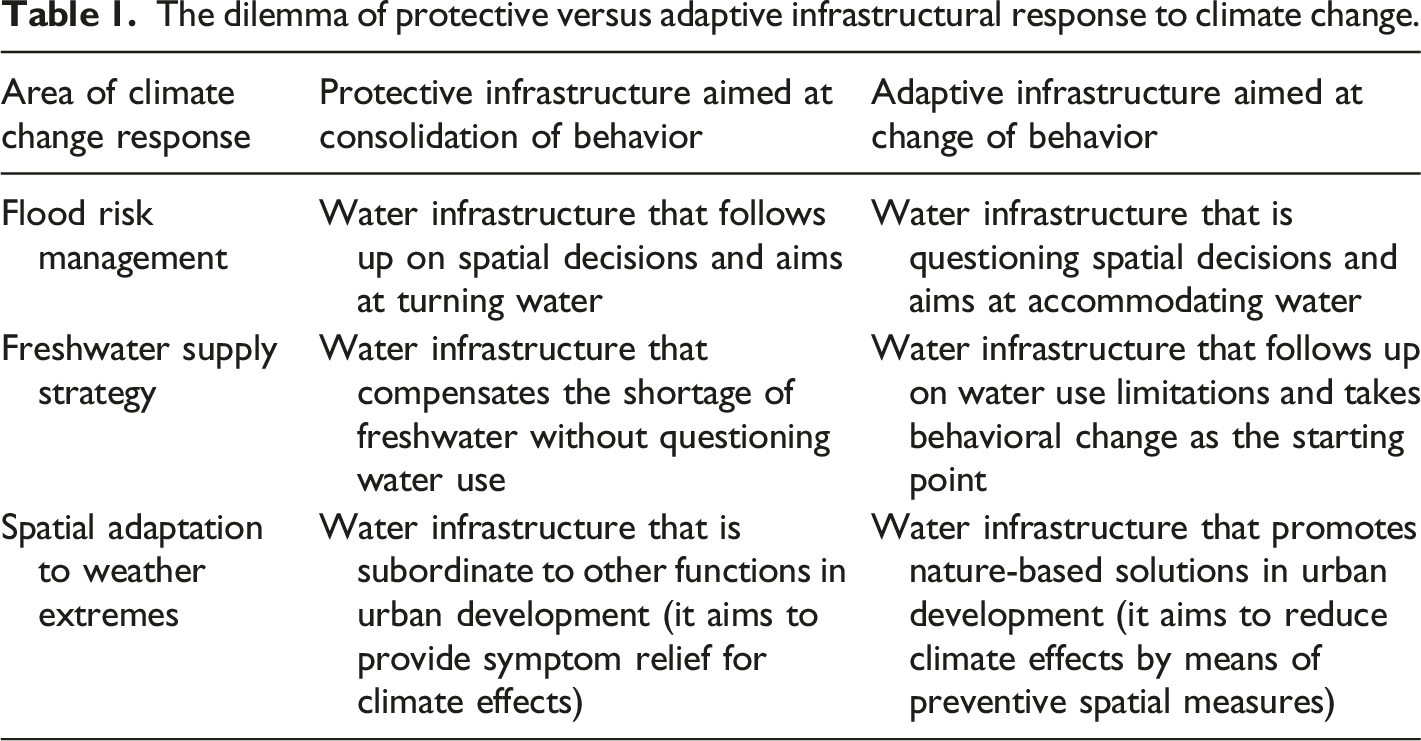
In three separate sections, we discuss how the Dutch invest in infrastructure for (1) flood protection, (2) freshwater availability, and (3) spatial adaptation to weather extremes. In each section we briefly compare the Dutch approach with the approach to similar problems in Florida. We identify dilemmas that occur in the relation between spatial decision making and decision making on infrastructural response to climate change. In that context we distinguish between protective and adaptive infrastructure. We conclude with a summary of challenges for those who want to further explore the adaptive infrastructural response to climate change.
Infrastructure for Flood Protection
More than half of the Netherlands (55%) depends on dikes for flood protection (“How Much Of The Netherlands Is Below Sea Level?,” n.d.). Partly because it is below sea-level (29%) or in flood prone areas along the main European rivers that flow into the Dutch Delta. If this infrastructure fails, 10 million people (of the 17 million inhabitants) are at risk. In 1953, the Southeastern part of the country was severely impacted by a flood disaster which claimed 1836 lives in one night; almost the same number of people that died due to Hurricane Katrina in New Orleans in 2005. Following that event, the Netherlands implemented the Delta Works Program to protect against floods from the sea that took 40 years, from 1956 until 1996 (Ministry of Infrastructure and Water Management, Rijkswaterstaat, n.d.), to construct. After severe river floods in 1993 and 1995 due to high water coming from inland Europe, the country started the Room for the River Program to better accommodate water in the river floodplains. From 1998 until 2018 huge investments have been made to develop corridors for resiliency along the main rivers (“Room for the River Programme”, 2019).
Despite all these efforts, the low-lying Netherlands are facing new challenges due to climate change. The Netherlands considered Hurricane Katrina in New Orleans as a wake-up call to consider. “What could go wrong if Dutch dikes were breached?” In 2011, the Netherlands began a new Delta Program (including a Delta Act, a Delta Fund, and a Delta Commissioner), based on various scenarios how climate change could impact the country through 2100. The website of the Government of the Netherlands (https://www.government.nl/topics/delta-programme) provides information about the organization of the Delta Program. It is forecast that the existing dike infrastructure along the coast and the main rivers will require a total upgrade before 2050 to stay prepared for sea level rise (which is going faster than expected) and increased river discharges. In 2014, a Flood Risk Management Program to improve existing dike infrastructure was begun. It was based on far higher safety standards than were previously in place and required that approximately 1300 kilometers of dikes and nearly 500 sluices and pumping stations, which are crucial for the water safety of the country, would have to be reinforced. 3
Despite its proposed benefits, the Flood Risk Management Program also generates many challenges and dilemmas. First, the implementation of the program is already delayed. It not only requires a lot of extra investment (one billion euros a year), but also sufficient executive power at the national and regional water authorities to negotiate and implement complicated processes of area development with the participation of many stakeholders. 4 The heavily engineered design approach often conflicts with the desires of stakeholders for a co-created plan that balances water management goals and good spatial integration. For instance, in various places the people who live along a river or in a coastal area oppose further reinforcement of dikes because it completely changes the landscape and the view at the waterfront. People want to be involved in plan development, they sometimes show NIMBY-behavior, and they want dike enforcement more integrated into the existing landscape. 5 Balancing public safety goals with private property rights in the area is quite a challenge.
Secondly, the Netherlands has a huge housing shortage and intends to build a million new houses in the next 10 years. The highest demand is in the lower areas of the country which are below sea level. However, most recent scenarios predict a sea level rise of 1.2 meters by the end of this century, while a rise between 1.5 and 2 meters will require a fundamental redesign of the Netherlands, with parts of the lower areas submerged. It is extremely challenging to make credible business cases for new residential development taking into account these long-term considerations. However, the market typically doesn’t want to think that far ahead and usually neglects the need to incorporate the future costs of protecting housing areas with extra flood defenses. For the Netherlands, sea level rise is accompanied by various spatial dilemmas (Schuttenhelm, 2019).
In the United States, an equivalent example of the Dutch need for increased flood protection and the wish for more urban development can be found in the City of Miami, Florida. The city is fast growing as the central gateway to the Caribbean and South America, but is also very vulnerable to sea level rise and has very limited space for adaptation. High tide flooding, also known as ‘Sunny Day Flooding’, happens more frequently when tides get 1.75–2 feet above the daily average high tide, spilling into city streets or bubbling up from storm drains (Rivers, 2021). The phenomenon is becoming increasingly common as sea levels continue to rise due to global warming, though land subsidence (the sinking of land), and other factors are also playing a role. The US Army Corps of Engineers proposes the construction of flood walls to protect the city (Mazzei, 2021), but Miami-Dade County rejects this approach and advocates instead for a sea level rise strategy with a variety of spatial adaption approaches, including building on higher ground (Staletovich, 2021). The South Florida Water Management District 6 argues that – additional to the sea level rise strategy of the County – more investments are needed in infrastructure for drainage and pumping, and for so-called ‘underground curtain walls’ to prevent seepage of water from the Everglades restoration area to the urban and agricultural areas of Miami-Dade County (South Florida Water Management District, n.d.). In South Florida, as well as in the Netherlands, conflict arises between urban development that relies on more engineered solutions versus a redesign of the area with more nature-based solutions, additional space for water storage, and displacement of urban development to higher ground.
Infrastructure for Freshwater Availability
The other side of this coin is that the Netherlands experienced severe drought during the summers of 2018, 2019, and 2020 which caused other problems such as salt water intrusion in the low-lying coastal areas, low water levels on the main rivers creating problems with shipping containers from the Rotterdam harbor to the European backland, increased demands for drinking water and falling groundwater levels due to heat stress and increased evaporation, and water stress for farming and nature conservation areas. Earlier, in 2015, the Netherlands undertook a Freshwater Supply Strategy to make the country more resilient to water shortage and drought. The strategy is based on optimizing the distribution of the available amount of water among users and water dependent functions, saving more freshwater by means of underground storage and elevating groundwater tables, and adapting to less water availability and diminishing the water footprint of the economy. 7
The Freshwater Supply Strategy also brings a number of challenges and dilemmas. First, the IJsselmeer, a former inland sea in the heart of the country closed off in 1936 with an enclosing dike which changed the water system from salt to freshwater, is the main freshwater reservoir for two thirds of the country and is managed by the National Water Authority. It distributes water into different parts of the country through a network of artificial waterways, based on a system of supply and demand codified in water delivery agreements between various Regional Water Authorities competing for sufficient water for their district. The distribution and redistribution of freshwater is going to be optimized using game theory to deal with rivalries about water shortage and formulating priorities for water use. 8 However, when the available freshwater stock in the IJsselmeer reaches a minimum level, the reservoir will not be available as an option for freshwater distribution (“National Delta Programme - Measures pertaining to the IJsselmeer Region,” n.d.).
Secondly, on a more regional scale of the catchment area, overuse of groundwater sources might result in a “tragedy of the commons” outcome 9 . The authorities currently have a few instruments to control water use and can prohibit the extraction of surface and groundwater for agricultural use in times of water shortage to guarantee some minimum flow, but to achieve better long-term governance of the commons, redistribution of water use rights might be an option. However, this conflicts with what the agricultural sector considers a right to farm. Redistribution of use complements water availability as a guiding principle in spatial planning (functions follow water availability instead of the other way around) and acceptance of limited water availability in certain areas. The delivery of sufficient freshwater cannot be guaranteed by water authorities which will thereby require more adaptation on the part of water users.
Thirdly, the only way to save more freshwater is to elevate groundwater tables and utilize the underground storage capacity. This will require acceptance of less drainage capacity to discharge rainfall, and more frequent flooding of agricultural land. This transformation towards water systems that are more based on groundwater conservation will require considerable stakeholder involvement, particularly with those having property rights in the area. It is a transformation from a more engineered water system aimed at draining water in wet circumstances as quickly as possible, to a system that is more based on water retention and utilizing the sponge capacity of the soil.
An analog of the Dutch freshwater crisis is also found in Florida. The state is running low on freshwater availability in Central Florida, in the Tampa Bay area, and in the southern part of the state (“Not Enough Drinking Water!,” n.d.; Southwest Florida Water management District, 1998, n.d.). Engineering solutions, such as upgrading waste water for reuse and distribution in a so-called purple pipe system, desalinization of salt water in water factories, and storing freshwater in huge open air freshwater reservoirs, like the Dutch do using the IJsselmeer as a huge freshwater reservoir are already in use. Moreover, problem pressure resulted in institutional reform, like the establishment of the Tampa Bay Water district (https://www.tampabaywater.org) and the Central Florida Water Initiative (https://cfwiwater.com). However, incentives for behavioral change are also needed to reduce the water footprint of the economy. The Water Management Districts in Florida operate a permitting system for consumptive use to control the amount of water used (Dunn, 2019). In Florida, as well as in the Netherlands, a dilemma occurs between continued uses of freshwater based on engineered solutions versus use limitations, saving of freshwater, reduction of water footprints, and redistribution of water use rights.
Infrastructure for Spatial Adaptation to Weather Extremes
A third expression of climate change is more extreme weather characterized by more urban heat and more rainfall peaks with heavier loads of rain. Two degrees Celsius of additional global warming might increase the amount of rainfall by 20 percent. The Royal Netherlands Meteorological Institute (KNMI) calculates with a 10 percent increase of rainfall intensity on average for every extra degree of global warming in Celsius (Abraham, 2017; Selten, 2022). Especially in highly developed urban areas with few green-blue infrastructures, this creates problems and a high risk of damage. For the Netherlands, it is foreseen that the country faces 170 billion euros in cumulated damage by 2050 if nothing extra is done on damage prevention. This will be mainly material damage to infrastructure, real estate, equipment, and movable property. Damage might be claimed at insurance companies, although this will likely increase the insurance fees due to increased risks and will also require preventive measures to be taken. In 2017, the Netherlands initiated a Spatial Adaptation Program to identify vulnerabilities to extreme weather, to start risk dialogues, and to decide what measures should be taken to prevent or reduce damage. 10
Four main challenges and dilemmas with respect to Spatial Adaptation have been identified. First, the Dutch approach aims to achieve balanced risk management. Some risks will be prevented by taking measures funded with taxation revenues which will require the political will to share costs among the public, i.e., solidarity. Other risks will be accepted, including a waiver of liability for public authorities. Ultimately, this will be a choice between public responsibility (solidarity) and individual liability (no duty of care for public authorities).
Secondly, the Netherlands are increasingly concerned about vital and vulnerable infrastructure. What will happen if roads providing access to a hospital, arguably a vital function in society, become inaccessible due to rainfall peaks? What happens if excessive rainfall flows into cellars with equipment for electrical or digital services? Can we keep vital utilities for energy supply or drinking water supply functioning in an area that is flooded? These are questions that must be addressed from the viewpoint of public security. In the case of weather extremes, water security is not only related to flood safety, but also to critical (vital and vulnerable) infrastructure, where failure could disrupt social functioning.
Third, in the Key Planning Layers Approach, often used in spatial planning (layer of the natural underground, layer of infrastructure, layer of occupation, etc.) 11 , the infrastructure layer can be overstressed by rainfall peaks, resulting in sewer overflows. To avoid this, rainwater could better be rerouted from the sewer system to open water (making use of infrastructure for open water in the occupation layer) or be infiltrated into the underground (making use of the sponge capacity of the natural underground layer). This would require ‘unsealing’ the soil by removing pavement or other means to increase its permeability. Adding nature-based solutions in urban areas where engineered-based infrastructure solutions still dominate could utilize a promising approach in urban planning and architecture called ‘landscape urbanism’. 12 The challenge here is how to elevate the ecosystem services that could be provided by ‘water and soil’ to a leading principle in urban planning and spatial decision making.
Fourth, most preventive measures will require space for open water and additional green-blue infrastructure in an environment that is already more than 95% developed. 13 Additionally, in the Netherlands, only 30% of urban space is publicly owned while 70% is in private hands. If open space, which is mostly in private hands (think of gardens, roof surfaces, parking lots, etc.) is to be considered a “common,” how is privately owned space to be accessed and used for public goals? How to we move from a ‘tragedy of the commons’, in which no space is left for green-blue facilities and the urban environment is degrading in terms for resiliency to climate change, to ‘governing the commons’ in a built environment? Can we increase the opportunities for multifunctional use of the built environment by stacking functions (like storing water on green roofs, which is already the standard in a city like Rotterdam, or using public open space for water storage, possibly underground)? In the Sea Level Rise Strategy of Miami-Dade County in Florida, we find similar adaptation approaches to that considered by the Dutch as suitable options for spatial adaptation: i.e., “Build Like The Keys,” “Build on High Ground Around Transit,” “Expand Greenways and Blueways,” “Create Green and Blue Neighborhoods,” “Build on Fill” (Flavelle & Mazzei, 2021; Miami-Dade County, 2021). In Florida, as well as in the Netherlands, the challenge is to find solutions that balance multiple competing (and often conflicting) objectives such as creating space for preventive measures, urban green-blue infrastructure, nature-based solutions, taking collective responsibility versus the acceptance of limited space in urban areas, a non-resilient urban landscape, and the risk of considerable damage for individuals for which they can obtain insurance.
Dilemmas and Challenges for Water infrastructure
The dilemma of protective versus adaptive infrastructural response to climate change.
In this commentary we have focused on the spatial dimension of water infrastructure, and have elaborated on infrastructure that is responding to climate change in a more adaptive way. We want to conclude with four challenges for those who want to further explore such an adaptive response.
Climate change requires extra space for water infrastructure - Infrastructure for water management often needs to stay in place instead of being neglected or abandoned. It is more a matter of refurbishment, renovation, reinforcement, or replacement to keep the assets in good shape. Additionally, protection from sea level rise and the effects of increased rainfall or drought mostly requires expansion of infrastructure for water management, and thus more space. Therefore, we could say that climate adaptation is primarily an issue of finding sufficient space. Especially in dense countries like the Netherlands, and in dense urban areas like New York City or Miami, this is a huge challenge (Goodell, 2018; Englander, 2021; van Lohuizen, 2021).
Water infrastructure needs space that is privately owned - While infrastructure for water management is often in public hands and may be considered as a public good, delivering water management services to society, the extra space needed for climate adaptation is not always available in the public domain. On average for the Netherlands, only 30 percent is public space, the other 70 percent is in private hands. This means that privately owned space will likely be needed to store runoff from peak storm events. A contribution from privately owned space to adapt to climate extremes seems to be crucial.
Nature-based infrastructure needs countervailing power - For more than 20 years the Netherlands have followed a strategy that water should not only be kept out from the country but also be accommodated. It has resulted in the adoption of more nature-based solutions to augment, the engineered controls that remain important. Expressions of this strategy are the “Room for the River Program” to improve safety from flooding along the rivers, the “Freshwater Strategy” to better utilize the natural storage capacity for freshwater, and the “Spatial Adaptation Program” to increase the resiliency to weather extremes by developing more green-blue infrastructure in urban areas. An implication of the choice to allow more accommodation of water is that spatial decision making should become more inclusive. Applying water and soil as a guiding principle (precondition) in spatial planning will sharpen the political debate on spatial decision making and require the institutionalization of countervailing power in the decision-making process to ensure that all stakeholders are heard.
Space is a common good that needs to be governed - The extra space that is needed for climate adaptation could be considered as a common pool resource to which dilemmas of collective action apply. Because water seeks the path of least resistance, retention space is a common good. It is not excludable (properties cannot be excluded from rainfall), while rivalry applies (those who do not accommodate water on their property shift the burden to others). Who is willing to give up land for extra water storage and serving a common goal, while this land could also be developed for other purposes with higher personal revenues? A tragedy of the commons will emerge if too much space for water retention disappears from dense areas. How to govern these commons? Applying pre-emption rights on specific low-lying areas to guarantee sufficient space for water retention? Or requiring retention compensation for buildings that are constructed on lower grounds where they reduce retention capacity? Spatial adaptation to climate change requires consultation and co-creation with stakeholders. It demands time, patience, and sufficient executive power from public authorities to achieve a good spatial integration for resilient infrastructure and to help an area to become climate proof for the future.