
Abstract
Rapidly sprawling development patterns in the United States have degraded aquatic resources and created affordable housing crises in urban cores. While public housing authorities (PHAs) combat urban affordable housing shortages, ecosystem service markets—such as the US Clean Water Act's wetland and stream compensatory mitigation program—concurrently seek to attenuate the environmental impacts of sprawling development. Using a case study of North Carolina's Durham Housing Authority, we explore how PHAs can leverage unused urban properties and wetland and stream mitigation programs as vehicles for funding their housing programs. Drawing on interviews with key stakeholders and literature and data on mitigation market operations, we employ geospatial, market, financial cost-benefit, and scenario analyses, identifying feasible, net-revenue-generating mitigation sites. We also identify several private-private and public-private partnership structures that could aid PHAs in implementing mitigation projects. Our findings suggest novel pathways for promoting environmental and housing improvements in America's central cities.
Keywords
Introduction
The rapid expansion of low-density, single-use development throughout the United States has simultaneously and significantly impacted affordable housing stocks and aquatic ecosystems in urban centers (Alberti et al. 2007; Rockett and Kazis 2022). In response, both federal housing and environmental policies have sought solutions through market-based approaches. In the former case, public housing authorities (PHAs) have proliferated and are now some of the primary entities addressing insufficient affordable housing across the country (McMarty 2014). The latter case is encapsulated by America's oldest and most active environmental market, which grew out of the US Clean Water Act's (Section 404; 33 USC 1251, et seq.) “compensatory mitigation” requirements. Under these regulations, which are triggered by urban development's frequent damage to wetlands and streams (Lave and Doyle 2021), unavoidable “impacts” (i.e., degradation; destruction) must be offset, typically using ecological restoration techniques that improve alternative, previously degraded aquatic ecosystems.
In this paper, we explore an opportunity to align the seemingly disparate goals and activities of PHAs with those of wetland and stream mitigation efforts. Numerous studies—extending back to 1997—have bemoaned the systemic and continued failure of mitigation policies—and the markets they create—to equitably offset wetland and stream damage in highly urbanized areas (King and Herbert 1997; BenDor, Brozović and Pallathucheril 2007; BenDor and Doyle 2009). Akin to a sort of “environmental gentrification,” this occurs when the very same land markets that create urban development systematically push mitigation offsets into rural areas, where land values are low and ecological restoration projects can be more easily and inexpensively sustained (NRC 2001; Stefanakis 2019; Klaus and Kiehl 2021). The gradual but steady shift of aquatic resources and their valuable “ecosystem services” (i.e., the beneficial functions of ecosystems; see MEA 2005), from urban to rural areas can disenfranchise and—given the growing health impacts of flooding and water quality degradation—endanger urban residents (BenDor, Brozović and Pallathucheril 2008; McKellips 2017; Ruhl and Salzman 2022).
Conducting mitigation on public land is one potential solution to the high land costs that incentivize mitigation to gradually “displace” aquatic ecosystem functions from urban to rural settings. Unfortunately, attention has fallen primarily—and controversially (Doyle et al. 2020; Pidot 2020)—on mitigation within federal landholdings.
In this paper we explore the possibility that PHAs may be in a unique position to address the challenges associated with implementing urban mitigation, as they often own portfolios of land parcels within highly urbanized settings where mitigation would otherwise be prohibitively expensive (Kleit, Airgood-Obrycki and Yerena 2019). Depending on their landholdings, some PHAs may be able to facilitate the restoration of wetlands and streams on otherwise unbuildable portions of their properties, where few, if any, other types of returns would be possible. PHAs could then use the revenue generated from subsequent sales into mitigation markets to augment their budgets and further their missions.
While some PHAs have leveraged a variety of creative financing opportunities, energy savings and GHG reduction programs (HUD 2025a), we are aware of no current PHAs that have engaged in wetland and stream mitigation. This is understandable as literature has pointed to mitigation as an endeavor that has major financial risks (Hook and Shadle 2013; Olander 2016), high knowledge and political barriers to entry (BenDor and Riggsbee 2011), and where regulatory preferences (e.g., BenDor and Doyle 2009) and scientific guidance (e.g., NRC 2001) have historically favored mitigation site placement in rural areas, where they typically experience less disturbance and require less maintenance.
However, the potential convergence of public housing and compensatory mitigation activities has also not received attention or evaluation within the academic or professional literatures. This is unfortunate, as scholarship in allied fields such as environmental finance (Vegh, BenDor and Cubbage 2025) and scenario planning (Chermack 2005; Hopkins and Zapata 2007; Amer, Daim and Jetter 2013) has long explored the potential risks and rewards associated with novel, but realistically actionable policy efforts. As examples, we point to Mandel, Donlan and Armstrong (2010, p. 44) proposal to employ derivative-based insurance contracts as a conservation tool for endangered species, whereby purchasers would be incentivized to “take preventative action to simultaneously protect their investment and decrease the likelihood of [species extinction].” Likewise, the Urban Land Institute (ULI) and Miami-Dade County (ULI 2018) generated a novel—and untested—transfer of development rights policy proposal that aimed to encourage retreat from areas at risk of sea level rise.
In the same spirit as these efforts, in this study we ask: How could involvement in wetland or stream mitigation markets impact PHA missions? How can PHAs assess the feasibility and cost/benefit structure of implementing mitigation within their real estate portfolios? What are the factors that affect PHA implementation of mitigation projects? We address these questions through a case study of the Durham Housing Authority (DHA), which has operated in the City of Durham, North Carolina since 1939 (DHA 2023). The DHA offers an ideal case study of this topic as it is strongly representative of many PHAs around the country in terms of its size, resources, and overall mission. The DHA's situation is also particularly interesting in that Durham straddles two rapidly developing watersheds within the Neuse River and Cape Fear River basins, which are home to some of the most active ecosystem service markets in the nation (USACE 2023b).
Drawing on geospatial, mitigation supply and demand, financial cost-benefit, scenario, and program analyses, as well as interviews with key stakeholders, we identify three potential DHA mitigation sites and several private-private and public-private partnership structures that could aid DHA in realizing these mitigation projects. Together, these sites contain wetlands (9 acres; 3.6 ha) and streams (11,229 linear feet; 3,423 m) of sufficient extent, health, and potential positive net revenue to warrant further evaluation for enrollment in mitigation markets. Overall, our findings support our contention that mitigation markets and public housing investments can—in certain circumstances—intersect to promote environmental and housing improvements in America's central cities.
Background
Wetland and Stream Mitigation
The history and regulatory framework of wetland and stream compensatory mitigation policy is complex, shaped by legal debates over the extent of federally regulated wetlands or streams (e.g., the US Supreme Court's 2023 Sackett vs. USEPA decision; 598 U.S. 651). Mitigation policy requires development projects (impactors) damaging wetlands or streams protected under the US Clean Water Act to offset their ecological impacts through a permitting program overseen by the U.S. Army Corps of Engineers (USACE). Impactors must restore, enhance, or preserve alternate wetlands or streams (USGAO 2024).
This can be done directly (“permittee responsible mitigation”; USEPA 2015b) or through third parties (mitigators) by purchasing mitigation credits (usually representing the area of land restored) from private firms (mitigation bankers) or “in-lieu fee” (ILF) programs managed by NGOs or governments (Berahzer 2015). Mitigation requires USACE approval to ensure sites meet ecological standards (e.g., vegetation growth, flood resilience). This approval process governs mitigation providers (supply) and their ability to sell credits to impactors (demand).
In 2008, the USACE & USEPA (2008) issued regulations—known as the “2008 Rule”—to enhance mitigation effectiveness by requiring measurable ecological standards, advocating a “watershed approach” for restoration site selection, expanding financial assurance requirements, and streamlining reviews. The Rule favored third-party mitigation (especially mitigation banks; USEPA 2015b), reducing permittee-responsible mitigation use from 60 percent to 33 percent (2008–2020; Inkinen et al. 2022) and increasing mitigation bank sites from ∼450 in 2005 to over 2,200 in 2022 (BenDor, Kwon and Lester 2023). A slew of regulatory changes to the Section 404 program during the early days of the Trump Administration are likely to have a range of impacts (and are likely to be legally contested), effectively increasing uncertainty in mitigation demand and altering—beyond the 2023 Sackett decision—the universe of wetlands and streams for which impacts would require mitigation or even permitting, altogether (Barho and Johnson 2025).
Mitigation and Risk
Creating mitigation sites involves long-term investment and risks (Hook and Shadle 2013; Olander 2016). BenDor et al. (2011) identified three intertwined types of risk that would apply to PHAs engaging in mitigation:
Public Housing Authorities
PHAs in the U.S. were first implemented as a component of the New Deal through the U.S. Housing Authority Act of 1937 (NLIHC 2019). Chartered under individual state laws, PHAs receive direct financial support from the U.S. Department of Housing and Urban Development (HUD) to support housing assistance and increase affordable housing stock in their communities (McMarty 2014). Today, nearly 3,300 PHAs across the U.S. work closely with local, state, and federal agencies on a range of activities to provide decent and safe housing to low-income families, the elderly, and people with disabilities (HUD 2023).
PHAs operate in a unique manner due to their close financial and operational ties with federal, state, and local governments (McMarty 2014). The term “quasi-governmental” is often used to describe PHAs as independent, private, not-for-profit entities that rely on federal, state, and local funding and technical support for their work (Kleit and Page 2015). While PHAs receive a majority of their funding from federal sources, the overall federal spending on affordable housing programs has declined since the 1980s, leading PHAs to adopt private, market-based approaches to carry out their mission (Kleit, Airgood-Obrycki and Yerena 2019).
The decrease in federal resources devoted to public housing was the result of a shift in federal policy that pushed PHAs to adopt a mix of private and public funding strategies (Kleit, Airgood-Obrycki and Yerena 2019). PHAs’ flexibility and authority to provide affordable housing through a mix of private and public partnerships and funding strategies has increased through programs like the HOME Investment Partnership (1976), the Low-Income Housing Tax Credit (LIHTC) program (1986), HOPE IV (1992), Moving to Work (1996), and the Rental Assistance Demonstration (RAD) Program (2012), (Nguyen, Rohe and Cowan 2012; Kleit, Airgood-Obrycki and Yerena 2019). While this gradual policy shift is the result of a steady effort to privatize public housing responsibilities and disinvest public funds from housing provision (Schindler and Moyer 2022), it has also given PHAs the ability to create for-profit, non-profit, and limited liability corporations, as well as limited partnerships, to assist in navigating a system that requires a mixed financing approach (Kleit and Page 2015; Gray 2017).
With the increased flexibility and authority to navigate public-private partnerships, we hypothesize that PHAs may benefit from mitigation strategies that generate assets from land unsuited for construction (e.g., due to the presence of floodplains or protected natural resources). By leveraging their central-city property portfolios and close relationships with local governments, PHAs may, therefore, further their public housing missions while providing ideal locations for city-center wetland and stream mitigation sites in spaces that typically price out mitigators.
Case Study
The Durham Housing Authority
The City of Durham is one of the fastest-growing municipalities in the State of North Carolina, having experienced a 25 percent increase in population between 2010 and 2020 (USCB 2023). This trend is likely to continue as the City's land use plan projects almost 20,000 acres (∼8100 ha) of land demand for development purposes by 2045 (City of Durham 2019).
Founded in 1949 to provide better housing opportunities for low-income persons, the DHA’s mission is to “develop, own, manage, and contribute to diverse communities of choice” by serving as the leading provider of affordable housing in the City of Durham (DHA 2023). As of 2023, the DHA has a full-time staff of ∼100, provides 1,201 public housing units, and manages 3,078 housing choice vouchers for local landlords (DHA 2023). The DHA has an annual operating budget of ∼$42 million, which includes expenditures for housing assistance payments ($21 million), low-income public housing ($10 million), and housing choice voucher program administration ($2 million; DHA 2021)
As the City of Durham continues to grow, both in population and geographical expanse, the DHA expects increasing strain on its capacity to meet the public's demand for affordable housing. Recognizing this challenge, the DHA's (2017) strategic plan highlights its intent to expand strategies that strengthen its financial stability and asset portfolio, build community partnerships, and promote community sustainability.
North Carolina Wetland and Stream Mitigation Market
The City of Durham, North Carolina offers an opportune case study of the potential for PHA-driven mitigation activity. The case is illustrative—and extensible to other jurisdictions—as the core driver of demand for wetland and stream restoration in Durham arises from the Clean Water Act's Section 404 requirements, which retain primacy across the country. Notably, BenDor et al. (2011) found that variation in demand for mitigation credits around the country is largely a function of the prevalence of wetlands and streams in the landscape that could be impacted by development. Therefore, holding all else equal (i.e., controlling for regional economic growth), areas with greater abundance of wetlands (e.g., Florida, Louisiana), and streams (e.g., Texas) often have more permitting activity and therefore more demand for mitigation credits—suggesting a greater relevance of this study for PHAs in these jurisdictions.
The Durham case is also opportune in light of the State of North Carolina's robust and unique approach to mitigation markets. The State was one of the first to incorporate stream-specific mitigation requirements as a major component of mitigation policy. The State has also established extensive, codified interactions between private and public entities (BenDor and Doyle 2009) for the purposes of mitigation planning. As part of this, it established a distinct state agency for mitigation management, the NC Division of Mitigation Services (NCDMS).
The NCDMS is a unique government agency that was originally formed as a publicly-supported ILF program to provide advance mitigation (i.e., mitigation prior to impacts) for the NC Department of Transportation (NCDOT), which through its construction of new transportation infrastructure, has long been the state's largest impactor of wetlands and streams (NCDMS 2023a). The primary objective of the NCDMS is to establish mitigation activities in advance of impacts to aquatic resources from future planned NCDOT projects.
The NCDMS, alongside the USACE, has evolved the market and regulatory structure into one of the most active programs in the country (Lave Robertson and Doyle 2008) through a statewide strategic plan for ecosystem services (NCDMS 2023c) and distinct Restoration Priority Plans for each of North Carolina's 17 river basins (NCDWR 2023). In 2020, the North Carolina General Assembly (via Session Law 2020-79) expanded NCDMS's role to include land acquisition and restoration and monitoring of projects that create or restore flood storage capacity. Today, the NCDMS administers four groups of ILF programs (Hill et al. 2013), including the aforementioned, Section 404 wetland and stream mitigation programs (the only programs evaluated in this study), as well as a statewide riparian buffer offset program (i.e., stream-side land that prevents flooding and erosion; Anbumozhi, Radhakrishnan and Yamaji 2005), and nutrient offset programs (i.e., nitrogen-focused water quality trading programs) in portions of the Catawba, Neuse, and Tar-Pamlico River basins (NCDMS 2023b).
Over time, the NCDMS has evolved into a mitigation credit clearing house for public impactors (local and state agencies), as well as private impacts in areas where adequate mitigation bank credits are not available (see NC Session Law 2009-337). Until the mid-2010s, the NCDMS created mitigation credits by contracting with separate environmental consulting firms to design, build, and monitor mitigation sites (called “design-bid-build”). However, challenges and risks in managing this process prompted the agency to largely shift to a “full delivery” process, where the NCDMS contracts with a single firm to plan, construct, and monitor a mitigation site in specific areas of need (NCDMS 2023d). Mitigation project sponsors seeking to partner with the NCDMS must go through a process—in addition to the USACE mitigation bank approval process—to participate in NCDMS's programs. Today, the NCDMS also frequently purchases and resells credits already created by private mitigation banks (NCDMS 2023b). This range of avenues for the provision of restoration sites suggests multiple pathways for PHA involvement in mitigation.
While the more specifically tailored, basin-wide programs run by the NCDMS may offer additional opportunities that are unique to the DHA, we want to re-iterate that the present study only evaluates involvement in the Section 404 wetland and stream mitigation programs, which remain in effect nationwide and are therefore applicable to other PHAs. Additionally, while the NCDMS does represent a unique institutional structure that the DHA may be able to leverage in certain circumstances, our analysis will evaluate a variety of other institutional and financial arrangements that are not unique to the DHA and may be replicable in jurisdictions around the United States.
Methods and Data
To gauge the feasibility and associated cost-benefit structure of any potential approach to constructing and selling mitigation credits with a given real estate portfolio, any organization—including PHAs—must understand several facets of their local mitigation market. First, they need to inventory the presence, composition, and relative health of aquatic resources within their property portfolio. Second, they must evaluate the potential demand for the mitigation credits that could be created on their property. This requires understanding the geographic area(s), known as the “service area(s),” that define which impacts can be offset at which mitigation sites. Typically, mitigation sites can only be used to offset impacts that are within the same watershed, basin, or other set of ecological boundaries (Womble and Doyle 2012). As part of this, they also need to evaluate existing and near-future credit supplies within their mitigation site's service area(s) to understand the relative level of competition for credits in the area.
Third, they need to project the associated costs and benefits of implementing a mitigation project through different mitigator partnerships (i.e., partnerships with mitigation bankers, with firms seeking to perform permittee-responsible mitigation, or with ILF programs). This will involve evaluating how partnerships with each of these types of mitigators could be established.
To perform these assessments, we conducted a regulatory and program analysis, which was augmented with information from key informant interviews. We also performed a geospatial analysis to determine potential mitigation sites on DHA property, an analysis of wetland and stream credit supply and demand, and we evaluated a series of cost-benefit scenarios arising from a variety of different structures of DHA-mitigator partnerships.
Interviews and Program Analysis
We began by interviewing professionals working across the institutions relevant to this study, including DHA staff, potential partners, mitigation providers, and regulators. Our interviewees included a member of DHA's Executive Office, a Project Supervisor for the City of Charlotte-Mecklenburg County Stormwater Services’ Stream and Wetland Umbrella Mitigation Bank (CSWUMB), and the Chief Mitigation Officer for the USACE Wilmington District. We conducted all semistructured interviews (Patton 2001) remotely using telecommunications software, recording and later transcribing the audio. Interviewees pointed us to a variety of program and regulatory documentation, which we leveraged for our program analysis.
Our program analysis considered DHA's organizational capacity (i.e., staffing levels, expertise, and available resources), the regulatory framework for stream and wetland mitigation in North Carolina, the City of Durham's watershed improvement planning efforts, and the operations of the CSWUMB, which may serve as a model for DHA's potential efforts. Our examination of the DHA focused on the organization's internal staffing levels, ongoing projects and programs, and budget constraints. We reviewed publicly available information on budgets (DHA 2021; City of Durham 2022), DHA's (2017) strategic plan, as well as the DHA's enabling regulations (and institutional modifications; i.e., the DHA Resolution; (City of Durham 2020), which provided details on DHA bylaws and operations.
We reviewed North Carolina's stream and wetland mitigation regulatory framework, analyzing the USACE & USEPA's (2008) promulgated rules that govern compensatory mitigation, as well as state laws governing compensatory mitigation for losses of streams and wetlands (15A NCAC 02H .0506(c) [1996]; 15A NCAC 02H .1305(c) [2003]). We evaluated the current urban/rural classifications (defined using US Census Bureau (2022) Designated Places data, which provide incorporated municipality boundaries) to evaluate the distribution of mitigation bank locations (using USACE's (2023b) RIBITS database) within our study area's two watershed service areas. We also analyzed the City of Durham's watershed restoration program by reviewing the Ellerbe Creek Watershed Improvement Plan (City of Durham 2023c) and the Third Fork Creek Watershed Improvement Plan (City of Durham 2023b). Finally, we reviewed the City of Charlotte's mitigation banking program, including mitigation feasibility reports (which have since been archived and removed from online public accessibility City of Charlotte 2023).
Geospatial Analysis
The first step in understanding whether mitigation is a feasible opportunity for DHA was to identify all DHA-owned properties that intersect a protected—or potentially protected—aquatic resource. We began by cross-checking the list of DHA-owned properties (provided by the Authority) with the City's comprehensive parcel dataset, obtained from the City of Durham's (2023a) Open Data Portal, which included property owner identifications. We then determined where DHA-owned parcels intersected known stream channels (which we filtered to remove waterways that were man-made [e.g., ditches], FEMA-designated floodplains (FEMA 2023), and wetlands. We obtained data delineating stream channels from the City of Durham (2023a) and data identifying wetlands from the U.S. Fish and Wildlife Service's National Wetland Inventory (USFWS 2023).
While available stream data are generally accurate and used by the City for planning and watershed management activities, the data unfortunately lack stream widths and channel classification (i.e., ephemeral, intermittent, perennial) attributes. Although this could conceivably impact mitigation feasibility in the wake of the recently modified legal definition of federally protected “Waters of the United States” (“WOTUS”; USEPA 2023b), recent assessments suggest that this is unlikely in the region (see Gold's 2024 spatial analysis). See Supplemental Material 1 for more information on our geospatial data limitations.
Once any potential mitigation sites were identified, we clipped streams, floodplains, and wetland polygons to DHA parcel boundaries (calculating their respective lengths and areas) and added a 50 ft riparian buffer in accordance with USACE (2016) requirements to assess whether a potential stream restoration project would intersect with non-DHA-owned properties (calculating the area of any overlaps). To increase the level of certainty for wetland areas identified by the National Wetland Inventory, we drew on the Natural Resource Conservation Service's (2023) Web Soil Survey which generates site-specific soil maps that provide parcel-level estimates of hydric soil composition, which is used as a primary indicator of wetlands by the North Carolina Wetland Assessment Method, the State's primary assessment tool for making wetland regulatory decisions (NCDEQ 2010). To be conservative, we removed wetland areas within the 50 ft riparian buffer from consideration in accordance with USACE regulations that prohibit mitigation projects from “double dipping” as both wetland and stream credits (USACE & USEPA 2008). We conducted all geospatial analysis using ESRI's ArcGIS Pro (v.3.2) software (ESRI 2023).
Mitigation Supply-Demand Analysis
To gain perspective on the stream and wetland mitigation credit markets for potential DHA mitigation sites in the Haw River and Upper Neuse River watersheds, we drew on Ungaro, BenDor and Riggsbee (2022) approach to evaluating stream and wetland credit supplies in Texas, comparing the volume and content of impact permits that required compensatory mitigation (i.e., mitigation demand) with the amount of existing mitigation credits available in the area (i.e., mitigation supply). Using an impact permit dataset, obtained from the USACE's (2023a) ORM2 database for the years 2017–2021, we selected only those permits requiring compensatory mitigation (n = 136), and organized and summarized the resulting data based on the watershed (Haw or Upper Neuse), the year permits were issued, and mitigation credit type (stream or wetland).
We identified annual, end-of-year credit availability (2017–2021) within each watershed using the USACE's (2023b) Regulatory ILF and Bank Information Tracking System (RIBITS) database. RIBITS contains a reporting tool that tracks credit information and summarizes it at the watershed scale (hydrologic unit class, eight-digit [HUC-8] watersheds; see Seaber, Kapinos and Knapp 1987 and for more information), which is the same geography that the Wilmington District of the USACE (covering the State of North Carolina) uses to define standard mitigation site service areas. RIBITS data includes details on the potential, released, withdrawn, and available credits for each approved mitigation bank and ILF site (i.e., all third-party mitigation sites). We calculated the sum of available stream and wetland credits in each relevant service area and compared the results to the average annual credit demand (calculated in the previous step).
Cost-Benefit Scenario Analysis
We performed a cost-benefit analysis for each of the potential DHA mitigation sites to assess their financial feasibility and programmatic constraints. We explored this through four scenarios that model different types of institutional partnerships and reflect different credit implementation costs and credit sales price assumptions. For simplicity, and to be conservative in our estimates, we assume that all impacts and required offsets are the same size, that is, a 1:1 “mitigation ratio.”
In Scenario A, we model DHA partnering with NCDMS, selling its credits at the ILF program's statewide credit price (2022–2023), and evenly splitting the net revenue generated. In this scenario, our estimates of DHA's mitigation implementation costs are informed by our interview with the CSWUMB supervisor and our review of Charlotte's mitigation program. The CSWUMB is a useful reference, as it operates in a similarly urban environment, is run by a public/quasi-public entity, and its administrative and staff-related expenses are funded through the City's stormwater utility fee. This means that it can sell its wetland and stream credits to local, public entities at their cost of production; as a result, its published credit prices solely reflect the planning, design, construction, monitoring, and maintenance costs for their mitigation projects (i.e., their cost of production). Therefore, for this scenario, we use CSWUMB's 2022–2023 average credit costs as an analog for potential costs of generating credits for DHA sites.
In Scenario B, we change DHA's mitigation implementation costs to instead equal those estimated by Hovis et al. (2022), who projected costs for establishing stream and wetland restoration projects (as well as other “natural infrastructure” practices) in rural eastern NC. These estimates reflect the opposite end of the cost spectrum from Scenario A. This scenario uses the same credit sales prices as Scenario A.
Scenarios C and D explore variations in credit sales prices, reflecting a possible DHA partnership with a private mitigation banker instead of the NCDMS. We adjust credit sales prices to reflect the DHA receiving 25 percent (Scenario C) and 75 percent (Scenario D) of the net revenue generated from mitigation sales, respectively. Both Scenarios C and D also use a baseline credit sales price by taking the average mitigation banking credit price, as reported in the NCDMS's 2021–2022 Annual Report (NCDMS 2022). Both Scenarios C and D maintain the higher CSWUMB cost estimates from Scenario A.
To account for any adjoining properties that intersect the project's riparian buffer, the cost of purchasing the necessary conservation easements was factored into the site's total implementation costs across all four scenarios. In order to calculate easement costs, we identified tax assessment land values for each parcel using data obtained from the Durham County (2023) Tax Administration's Real Property Record Search. The tax assessed per-acre value of each property was then multiplied by the total area that intersected the riparian buffer of that property, which we identified during the geospatial analysis.
The prices of mitigation credits can vary annually based on several factors, including (1) credit availability (i.e., supply, as determined by the size and number of mitigation projects approved by federal regulators), which is contingent on mitigation sites meeting annual performance standards, (2) annual permitted impacts requiring compensatory mitigation, and (3) per unit cost of construction material and labor, among other factors. Therefore, for all scenarios, we calculated the total net revenue for each mitigation activity by subtracting total implementation costs from a discounted revenue stream across the nine-year project credit release schedule. We calculated the discounted annual net revenue by multiplying the total length (area) of the restored stream (wetland) for each site by the proportion of total credits released for each year, according to the USACE Wilmington District's nine-year credit release timeline (see Table S1). For each year, we applied a seven percent discount rate, as required by the NC Office of State Budget and Management (NCOSBM 2023), for cost–benefit scenario analyses in projects completed by public agencies.
Results
Program Analysis and Interviews
Any involvement in mitigation would first require a fundamental, ethical decision by the DHA—one that has regularly confronted other governments and public service entities in the same situation (e.g., see Doyle et al. 2020) by improving wetland and stream ecosystems to act as offsets, DHA would be tacitly enabling permitted impacts that could negatively affect localized aquatic resources elsewhere in Durham's watersheds. Would the DHA be willing to engage in this process knowing that its actions would, in part, facilitate environmental losses elsewhere—even if its actions prompted a net environmental improvement? Ultimately, public entities of various types have come down on both sides of this question, and any PHA should carefully and explicitly consider where they fall on this issue.
Challenges and Opportunities for Urban Mitigation
Stream and wetland mitigation activities most often occur outside of urban environments where larger, less expensive, and more connected tracts of aquatic resources and land can be found (Hill et al. 2012; NRC 2001). This can certainly be seen in North Carolina; our analysis of the locations of current mitigation banks in the state revealed that only 8.5 percent (36 of 422; Figure 1A) of sites were located in an urban setting (which we defined as within the boundaries of a US Census (2022) Designated Place, i.e., almost any named municipality or settlement). Localized to our study area, our analysis revealed that only 5.6 percent of mitigation banks and ILF sites were located in urban settings (5 of 90; Figure 1B).
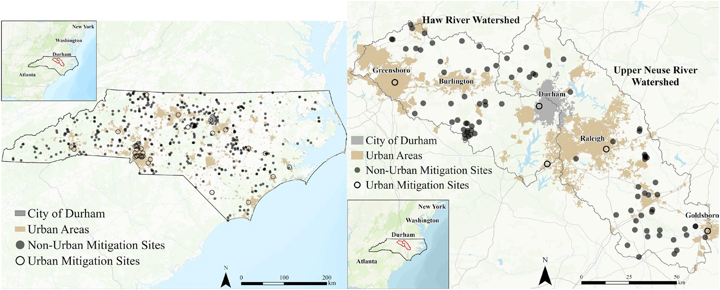
(A) Urban and non-urban mitigation bank and in-lieu fee (ILF) sites in North Carolina. (B) Urban and non-urban mitigation bank and in-lieu fee sites in the Haw River and Upper Neuse River watersheds.
Several interviewees noted that a major challenge that increases the risk and upfront cost of urban mitigation for mitigation banking firms and other entities concerns the acquisition of land or conservation easements for mitigation sites. First off, in order to obtain access to enough stream length or wetland area to meet the overall mitigation objectives of urban mitigation banks or ILF projects, the organizations implementing these projects are commonly required to obtain many—dozens, if not hundreds, in the case of streams—of conservation easement agreements from local residents and businesses, on whose land the mitigation will be performed. Our interview with the CSWUMB supervisor underscored this point, highlighting that one of the primary challenges in urban mitigation involves managing this multitude of conservation easements. As a result, the responsibility of preservation, conservation, restoration, and enhancement of aquatic resources located in urban settings usually falls onto non-profit organizations or local, state, and federal government entities, which can justify expenditures on projects with higher costs that would otherwise severely upend project profitability.
However, the CSWUMB supervisor noted that even for sites created by non-profit organizations or local governments, acquiring easements on privately held land can be a lengthy—and sometimes charged—process when a majority of landowners agree but a few residents hold out, slowing the project as all required conservation easements must be obtained prior to initial credit releases. Managing these easements in perpetuity also requires extensive staff time to ensure current and future landowners understand where these easements exist on their properties, as well as the associated use restrictions that they involve.
Our interview with the Chief Mitigation Officer of the USACE Wilmington District Mitigation Branch revealed that the existing site conditions on potential urban mitigation sites can also pose major barriers; for example, urban utility infrastructure, such as sewer and electric lines, are often located in the same low-lying and flood prone areas as remnant urban stream and wetland areas, which have resisted conversion into urban land uses over time. The easements that are universally required for utility infrastructure makes placing subsequent conservation easements, which are universally required for mitigation sites (USACE & USEPA 2008), challenging or impossible. The result is restoration projects that are designed in piecemeal and disjointed fashions, which generate fewer credits, and have lower potential for ecological “uplift,” which Johnson and Whitworth (2016, 78) define as, “…the difference between [a site's] degraded baseline conditions and future restored conditions.”
These challenges posed by urban mitigation represent a major opportunity for the DHA in that the organization would be implementing mitigation on land it either owns or has the potential to acquire at little to no cost. USACE's Chief Mitigation Officer also noted that, due to the lack of mitigation projects being constructed in urban areas around the State, increased mitigation ratios—the amount of mitigation required for a given impact—may be granted to urban mitigation projects. An increased mitigation ratio would mean that the DHA would receive more credits for every acre of wetland and linear foot of stream restored, positively affecting DHA's overall earning potential. The CSWUMB supervisor also discussed the impact of regulatory decisions on mitigation ratios, noting that ratios are determined during the mitigation instrument approval process based on regulator-established priorities for a given HUC-8 watershed.
Partnerships
Our interviewees strongly suggested that the regulatory requirements, difficult market analysis, and extensive staff workload over the 10 + year time frame required to independently implement a mitigation bank would almost certainly exceed most PHAs’ organizational capacity and expertise. Therefore, considering partnerships as a key factor, we can frame DHA's potential strategies for entering the mitigation market along a continuum that reflects tradeoffs between required upfront investments (and risk) and DHA's potential long-term mitigation revenue. Therefore, realistically, these options range from DHA maintaining complete control over mitigation projects and accepting all risks, to DHA acting simply as a land provider for external organizations, with little upfront investment, virtually no risk, and comparatively low revenue.
The first set of options available to the DHA fall on the “high risk/high reward” end of this continuum and involves the DHA fully entering the mitigation “business,” partnering with external organizations to physically restore wetlands and streams on DHA land and subsequently taking full ownership of resulting wetland or stream credits. The DHA could, for example, partner with one of the many mitigation firms in North Carolina (USACE 2023b), some of which have experience in urban environments. The DHA could approach this option in several ways, including contracting with a mitigation provider to complete a “full delivery” project, which would involve the provider conducting detailed feasibility studies, fulfilling all permitting and regulatory requirements, and completing mitigation design, construction, and site monitoring activities. In this case, the DHA would manage transactions throughout the project life of the site.
As another option, like the early “design-bid-build” approach of the NCDMS, the DHA could instead contract an engineering or mitigation banking firm to design and build the project, while partnering with either a land trust, local government, or local research institution to conduct required annual monitoring, maintenance, and data collection on the site. While these approaches would require a larger upfront cost, the DHA would stand to receive all revenue from subsequent credit sales throughout the life of the mitigation site. This would involve much higher levels of involvement on the part of the DHA.
A set of lower risk options available to the DHA includes forgoing the responsibility of managing the implementation process of a mitigation site and instead leveraging their urban real estate portfolio through conservation easements. The DHA could work with NCDMS and/or a mitigation provider to sell the conservation easements for the land necessary to implement a mitigation site. There could be several options available to the DHA when selling easements, including directly partnering with NCDMS, selling easements to mitigation providers (i.e., acting as a land supplier, only), and partnering with a provider where the DHA leverages easements as their investment and receive a share of the revenue generated by credit sales. While these options reduce risk by eliminating the high upfront costs associated with navigating the complex and uncertain permitting and construction process, the DHA would receive reduced overall returns in comparison to fully entering mitigation “business.”
Our document analyses and interviews suggest that DHA could leverage their existing relationships with local and state organizations in myriad ways to both relieve capacity restraints and increase revenue from potential mitigation projects. For example, the DHA could instead choose to partner with the City of Durham; along with regulatory expertise, staff in the City's Stormwater Division operate a Watershed Restoration group, which evaluates and implements improvement projects across the eight HUC-12 watersheds covering the municipality (City of Durham 2023c). In 2012, the Watershed Restoration group completed a watershed management plan for Third Fork Creek and identified “keystone properties” (critical lands near a large protected area) and “urban gems” (smaller, high-quality parcels in the watershed's more urbanized areas) that are high priority parcels for watershed improvement projects (City of Durham 2023b). These properties have been prioritized by the City for restoration, conservation, and preservation projects to improve the Third Fork Creek watershed.
Depending on where potential mitigation sites could be located, they may be in proximity to the City's prioritized watershed improvement areas, which would be a convenient way of fulfilling the USACE's watershed approach for mitigation banking (USACE & USEPA 2008). As a result, the City's ongoing efforts in the Crooked Creek, Eno River, Falls Lake, Third Fork Creek, Ellerbe Creek, and nine other watersheds could present an opportunity to follow Charlotte's example and form an “umbrella” stream and/or wetland mitigation bank (an umbrella bank is a regulatory term for several mitigation banking sites managed by one organization; Prickett et al. 2013; Theis and Poesch 2022). Due to DHA's close relationship with the city and the shared goals between the organizations, a partnership between the two may be beneficial. An agreement between the DHA and City of Durham to share up-front investments and funnel subsequent revenue in support of affordable housing would benefit both organizations.
Geospatial Analysis
Our geospatial analysis revealed three potential mitigation sites on DHA property (Figure 2A). Sites 1 and 2 are in south Durham and include portions of Third Fork Creek, which is part of the Haw River watershed (HUC-8 03030002). The Third Fork Creek watershed covers an area of 16.6 mi2 [43 km2] and is home to the second highest population density among Durham's eight HUC-12 watersheds. Since 2005, Third Fork Creek has been officially listed by the USEPA as an “impaired waterway,” exceeding fecal coliform, mercury in fish tissue, sediment, and turbidity standards, and appearing on the Clean Water Act's Section 303(d) list of impaired waterbodies requiring restoration activities to achieve water quality goals (USEPA 2023a). The City has been required to plan and implement restoration activities to meet total maximum daily load (TMDL) limits, a calculation of the maximum number of pollutants that can be present in a waterbody while still meeting water quality standards (USEPA 2015b). While Third Fork Creek remains on the 303(d) list as of 2020, ongoing efforts by the City, including drafting a watershed management plan in 2012 and continued restoration projects, have slowly begun to improve the stream's water quality (City of Durham 2023b).
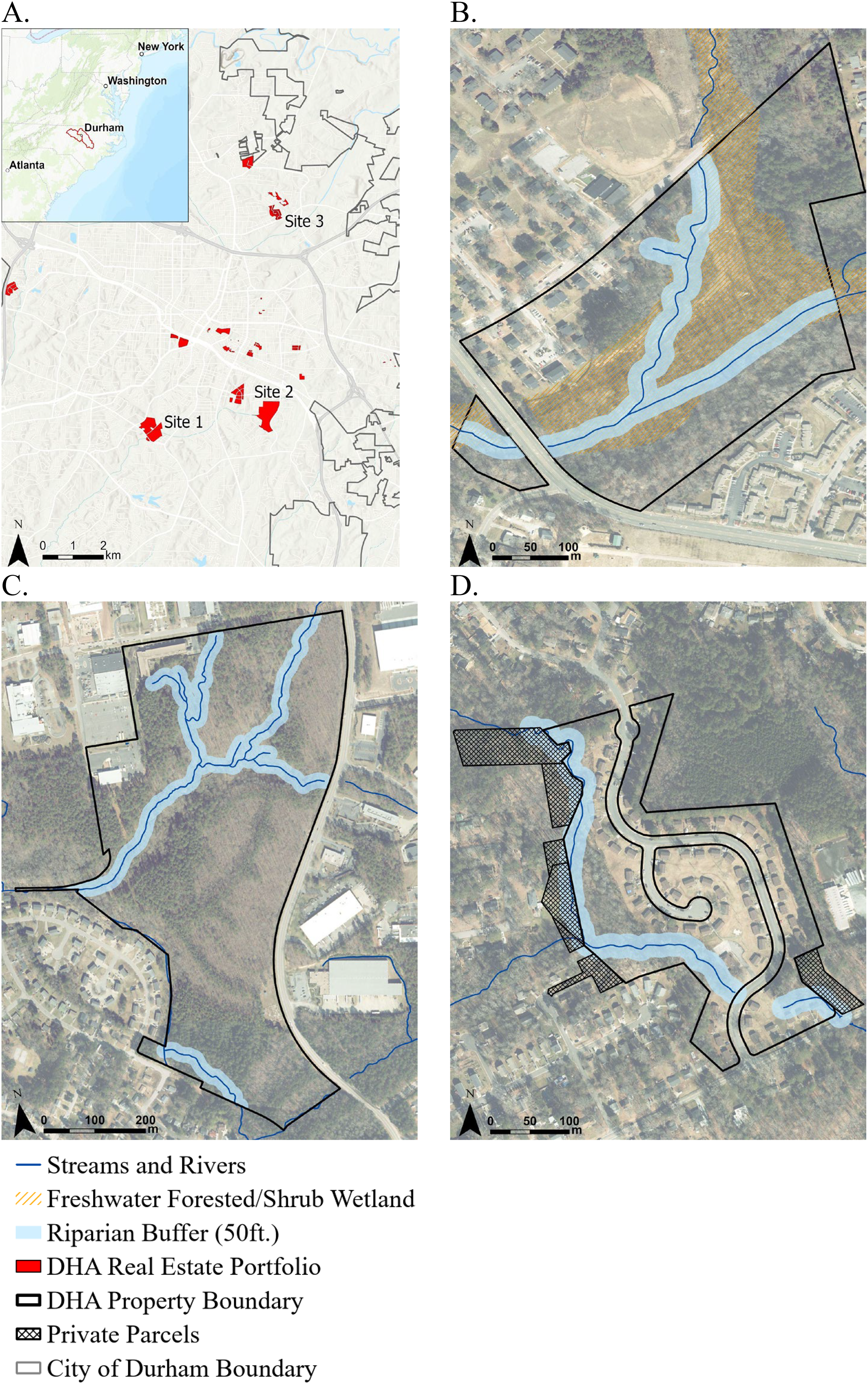
(A) Durham Housing Authority (DHA)'s real estate portfolio in the city of Durham, North Carolina, and potential mitigation sites, (B) Site 1, (C) Site 2, and (D) Site 3.
Site 1 (Figure 2B) contains an existing affordable housing development with several structures. The parcel contains approximately 3,191 linear feet (972.6 m) of Third Fork Creek and 14.24 acres [5.76 ha] of freshwater forested/shrub wetlands, of which 9.1 acres [3.68 ha] would be available for restoration due to the necessary removal of 5.14 acres [2.08 ha] to account for stream restoration required riparian buffers. Site 2 (Figure 2C) includes a longer reach of stream than Site 1 with approximately 5,863 linear feet [1,787.04 m] of Third Fork Creek. Composed of three adjoining parcels, Site 2 is not actually a current part of the DHA portfolio but could be accessed through a partnership with NC State University and the NC Agricultural Foundation (see Supplemental Material S2).
Finally, Site 3 (Figure 2D) is located on a multi-parcel DHA development and includes a tributary of Ellerbe Creek, a contributor to the Falls Lake reservoir, which defines the outlet of the Upper Neuse River watershed (HUC-8: 03020201). The entirety of Ellerbe Creek has been listed on the 303(d) list since 1998, with water contact recreation impairments arising due to levels of fecal coliform bacteria and other pollutants that exceed water quality standards. Site 3 contains 2,175 linear feet (663 m) of stream along with a riparian area that separates DHA's development from another privately owned development. Stream restoration on the site would require a 50 ft (15.2 m) riparian buffer, which would result in the project intersecting three privately owned parcels. Unlike Sites 1 and 2, this would require the DHA to obtain conservation easement agreements from affected private landowners. We captured these costs in our cost-benefit analysis (discussed more below) by calculating the area of intersection for each individual parcel within the riparian buffer, which included 1.28 acres (0.52 ha) across six properties.
Sites 1 and 2 are both directly adjacent to two or three “keystone properties” and near at least one “urban gem property” connected by a similar reach of Third Fork Creek while Site 3 is located in a city-designated high priority protection area (Wilbur 2021; City of Durham 2023b).
Market Analysis
We can assess the demand for mitigation by looking at trends in aquatic resource impact permits—requiring stream or wetland credits—issued in the Haw and Upper Neuse Watershed service areas (Figure 3). The Upper Neuse Watershed had a greater amount of these permits every year and aquatic resource type in comparison to the Haw Watershed. Table 1 compares annual credit availability to annual credit demand over the five-year period, 2017–2021. The number of available credits in each watershed suggested that the markets of both watersheds were routinely saturated, except for the Haw watershed, which often had wetland credit shortages.
Permittees required to compensate for impacts using mitigation and in-lieu fee credits between 2017 and 2021 in the Haw river watershed (service area of potential Durham Housing Authority [DHA] sites 1-2; hydrologic unit class [HUC] 03030002), and Upper Neuse Watershed (service area of potential Site 3; HUC 03020201).
Market Analysis Showing Credit Demand by Permittees (2017–2021; source: USACE 2023a) and Credit Supply (availability) by Mitigators (2017–2021; source: USACE, 2023b) in the Haw River and Upper Neuse River Watersheds.
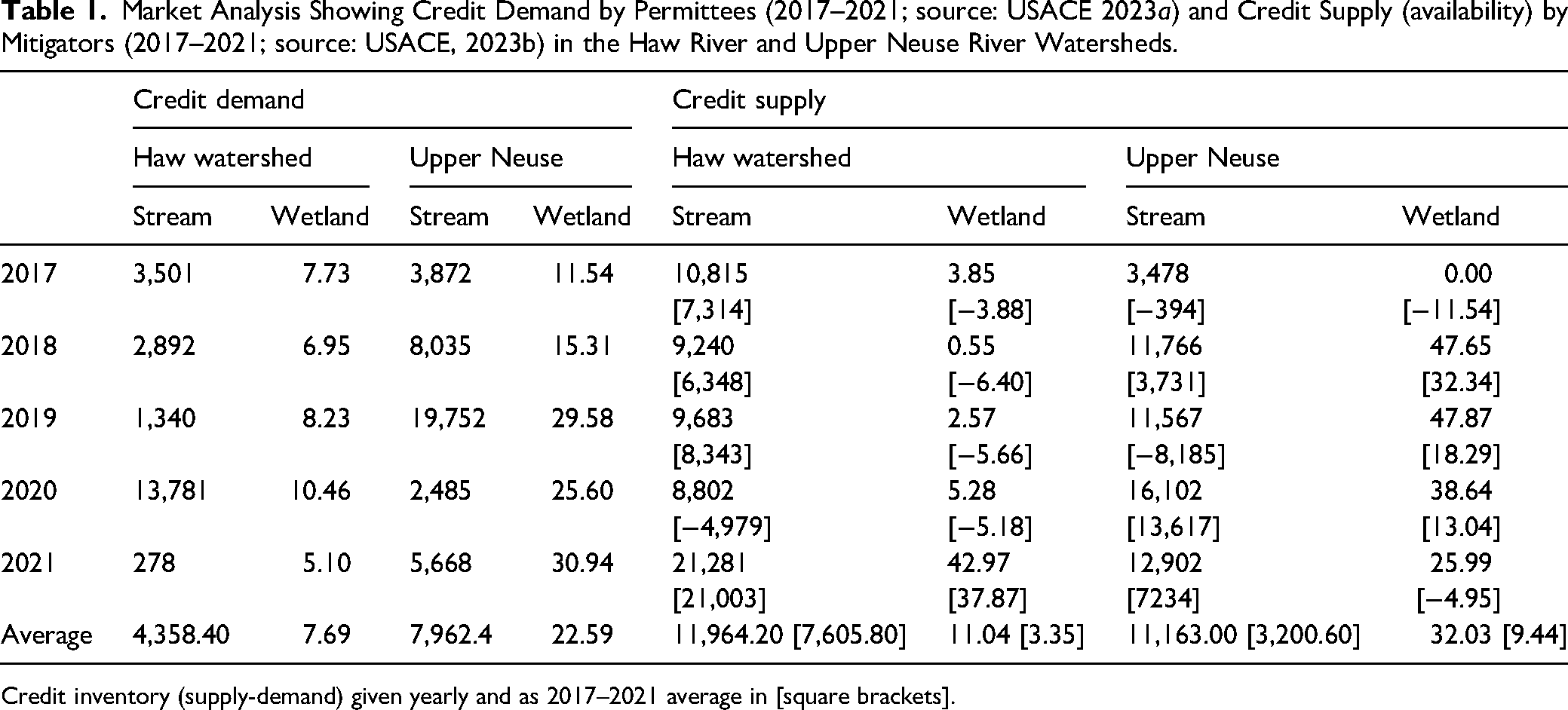
Credit inventory (supply-demand) given yearly and as 2017–2021 average in [square brackets].
However, the CSWUMB Project Supervisor noted that constant changes in existing and new development projects created strongly fluctuating demand for stream and wetland credits. Moreover, the long project timelines of mitigation banks can make them difficult to react to market forces; they offered a recent example involving the one-billion-dollar Charlotte-Douglas International Airport's expansion (Lee 2023). The project required large amounts of compensatory mitigation credits from the City's mitigation bank to offset wetland and stream impacts, essentially clearing out the City's available credits in the Lower Catawba Watershed. The airport expansion was only announced in 2021, leaving Charlotte's mitigation bank little time to bolster their credit stock. While this example is extreme, it demonstrates that having a reserve/excess of credits in a watershed does not necessarily mean there will be limited near-future demand for any given bank's credits, especially in urban areas where large development projects occur regularly.
Cost-Benefit Scenario Analysis
We assessed four potential scenarios, varying the credit price and implementation cost of mitigation activities (Table 2; all prices in 2023 USD). As the CSWUMB's credit prices closely reflect their implementation costs, we relied on them for Scenarios A, C, and D, using the average stream credit price ($646/credit) used across the Upper Catawba (HUC-8 03050101), Lower Catawba (03050103), and Rocky (03040105) River Watersheds as the proxy for DHA's implementation cost estimates. The CSWUMB provides wetland credits at the same price for each watershed, charging $70,939 per credit. While we initially sought to reduce these prices to account for Charlotte's real-estate expenses that the DHA would not have to contend with, in the end, we decided that separating these costs was ambiguous as a result of information collected during our interview with CSWUMB staff. We discovered that their real estate-related expenses were surprisingly low and likely not representative of other public programs (see Supplemental Material S3).
Cost-Benefit Scenario Analyses Under Varying Conditions of Implementation Costs (IC) and Credit Sale Prices.
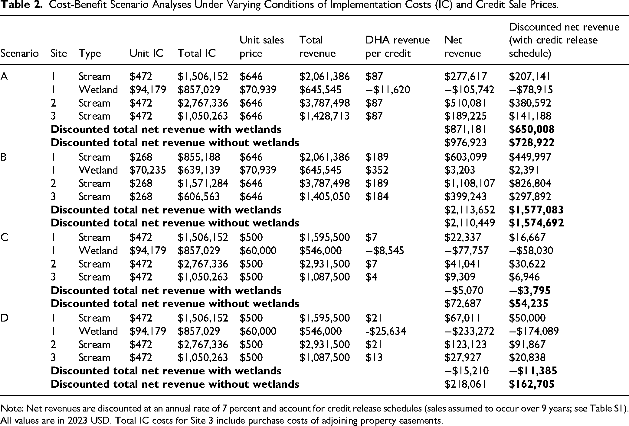
Note: Net revenues are discounted at an annual rate of 7 percent and account for credit release schedules (sales assumed to occur over 9 years; see Table S1). All values are in 2023 USD. Total IC costs for Site 3 include purchase costs of adjoining property easements.
Across all four scenarios, stream restoration on DHA sites consistently returned positive net revenue (i.e., revenue subtracting mitigation implementation costs). In contrast, wetland restoration on Site 1 resulted in an almost universal, net revenue loss across scenarios, with only Scenario B—which reduced implementation costs by an approximate 25% from $94,179 per acre to $70,235—barely breaking even (with a net revenue of ∼$3,000). This finding confirms the urban wetland restoration challenges highlighted by our interviewees, as well as published investigations that have found large-scale wetland restoration in urban areas to be both expensive and difficult to maintain (Ravit et al. 2017; Alikhani, Nummi and Ojala 2021; Canning et al. 2021).
When we sum net revenue across the sites for each of the scenarios (excluding when wetland restoration resulted in a net loss), we see that Scenario B—which assumes the lowest implementation cost and an even split of revenue generated by the distribution of credits through NCDMS—has the greatest return of just over $2,113,652. At the other end of the net revenue spectrum, Scenario C—which assumes DHA receives 25% of net revenue from credits sold at NCDMS average credit sales prices– generates the lowest total net revenue (excluding wetland restoration) of just under $72,687.
Discussion
Our goal in this case study has been to assess the feasibility, costs and benefits, implementation factors, and impact on the DHA's overall mission of involvement in creating wetland and stream mitigation sites. Our study has revealed that stream mitigation (but likely not wetland mitigation) on DHA property has the potential to make a positive contribution to DHA's budget, helping the organization to increase affordable housing options in the City of Durham. On otherwise unused parts of properties owned (or easily obtainable) by the DHA, we identified three potential mitigation sites with one or more restorable stream reaches that are (1) large enough to justify mitigation activities and (2) have direct relevance to ongoing municipal planning efforts to protect surrounding watersheds and provide residents with important ecosystem services.
The results of our cost-benefit analysis suggest a wide range of outcomes that DHA could achieve through the implementation of mitigation sites under varying conditions. Estimating credit sales prices is a challenging task due to the geographically specific “service area” markets, rates of credit demand by permittees, the stock of available credits, and labor and material costs. These results offer only a basic assessment, based on publicly available information, of what the DHA would need to consider financially when implementing mitigation.
However, while we found an excess supply of stream mitigation credits available relative to average annual credit demand, problems with data accuracy, delayed credit production, and “lumpy” demand for credits from large infrastructure projects complicate the story. Moreover, under almost all scenarios, cost-benefit analyses of mitigation on the three sites resulted in positive net revenue that could bolster DHA's mission and contribute to affordable housing projects.
While the scenarios illustrated in Table 2 clearly point toward a DHA partnership with the NCDMS ILF program as the most fiscally viable option, it is important to caveat that the NCDMS does not constantly buy all available credits within a watershed. Instead, NCDMS uses a statewide strategic plan that incorporates an overall watershed planning approach with specific goals and objectives. These and other influences contribute to the NCDMS's bidding process by which the organization creates the credits deemed necessary for a service area. Watershed conditions and associated planning goals and transportation infrastructure projects are prone to constant change. In one year, the NCDMS may require a large number of stream credits, and in the next year, it may require no stream credits but a large quantity of wetland credits for the same service area.
Selling credits directly to permittees could help to reduce this uncertainty when a site is established in a watershed experiencing high rates of urban sprawl, which frequently impacts aquatic ecosystems. When assessing whether a prospective site's credits could have sufficient demand, our interviews suggest that forming relationships with local development firms, as well as extensive research into the area's growth, are best practices often followed by successful private mitigation provider organizations. As discussed previously, the DHA's relationship with the Durham local government could further assist them since no organization or person has a deeper understanding of ongoing and future development than the local government of that area.
Impact on DHA's Strategic Mission
Overall, our program evaluation suggested that DHA's involvement in mitigation could align with its overall mission and strategic plan. Interviews with mitigation providers and regulators identified key challenges facing the DHA if it decides to move forward with implementation, as well as a key advantage that DHA and other PHAs have in implementing mitigation projects among their own real estate portfolios.
Mitigation is one strategy that the DHA could explore to meet several of these goals and better prepare the organization to meet the growing demand for affordable housing in Durham. By implementing mitigation projects, the DHA would not only strengthen its financial stability by diversifying revenue sources, but it could also enhance its asset portfolio by increasing the attractiveness and environmental functionalities of its properties through mitigation activities. Beyond the financial benefits, mitigation could provide vulnerable populations housed in their developments with greater access to well-maintained and protected ecosystems in an urban environment, which typically sees some of the greatest environmental degradation. Several studies have found links between urban green space and increased mental and physical health in residents (van den Bosch and Ode Sang 2017; USDA 2021). While the purpose of mitigation is primarily to improve the quality and functionality of aquatic resources, a large body of literature has shown that these practices can also mitigate many of the impacts of urban heat islands, which are caused by impervious surface cover retaining heat (Madureira and Andresen 2014; Saaroni et al. 2018; Abdulateef and Al-Alwan 2022).
Implementing mitigation projects could also foster new and diverse relationships with both the private and public sectors, as the DHA would need technical—and possibly, funding—support. As a quasi-governmental organization, the DHA already has a close working relationship with the City of Durham, which is already actively working to implement six watershed improvement plans (City of Durham 2023c). The City's accumulated experience from ongoing watershed improvement activities and connections to private and public organizations in the field of environmental preservation, conservation, restoration, and enhancement, could assist the DHA in exploring stream and wetland mitigation as a feasible strategy for meeting its goals.
Conclusions
PHA Advantages
Typical mitigation projects can be difficult to implement in urban settings for many reasons. Acquiring land for mitigation in urban environments can be costly and complicated by large number of landowners typically involved. However, PHAs—like the DHA—have several unique advantages that—under very specific circumstances—could ease the financial and technical challenges of urban stream and wetland mitigation. First, PHAs have urban real estate portfolios that could facilitate the implementation of mitigation projects in highly sought-after urban areas, where some of the most degraded aquatic resources are located. These projects could be implemented at reduced costs, making these projects much more financially feasible for PHAs than for virtually any other mitigation provider.
Second, PHAs’ unique relationships with local governments and NGOs could help some PHAs better leverage local experience in aquatic resource preservation, conservation, restoration, and enhancement work, helping them to overcome the technical, planning, and implementation barriers that make mitigation projects extremely difficult for most organizations.
Third, potential synergies with PHAs’ housing missions suggest innovative direct and indirect benefits of PHAs engaging in ecosystem service markets. Beyond establishing a new funding source to support ongoing and future affordable housing projects, the ecological uplift from restoring and protecting degraded urban aquatic resources can create a plethora of ecosystem services—like increased water quality, habitat integrity, and flood mitigation benefits (Alberti et al. 2007; Alikhani, Nummi and Ojala 2021). These ecosystem services can also create spillover effects as nearby PHA residents experience increased environmental education opportunities (de Bell, Graham and White 2020) as well as physical and mental health improvements through greater access to natural features in urban settings (Remme et al. 2021). Together, these advantages could make ecosystem service markets a potentially useful tool for helping PHAs achieve their missions and provide decent and affordable housing for the communities they serve.
Overall, however, PHAs’ relative advantages in urban mitigation can be leveraged in very specific situations; our analysis suggests that properties owned by PHAs must have significant amounts of degraded aquatic resources to make the effort of implementing mitigation projects worth the investment. Moreover, there needs to be sufficient demand for mitigation credits in the service area(s) where those lands are located in order for the PHA to see positive returns. Implementing mitigation in urban environments is far more challenging and costly in comparison to more rural settings, and this reality may impede the ability of many PHAs to enter competitive markets. Given their comparative inexperience in navigating the complex process of designing, obtaining approval for, implementing, and managing mitigation projects, PHAs will need to form effective partnerships with experienced private and public mitigation organizations.
Caveats to PHA Involvement
Accompanying the advantages of PHA involvement in mitigation are two major caveats. First, one of the major advantages that PHAs bring to ecosystem service markets actually raises a question of fairness; the urban real estate portfolios that could supply PHAs with mitigation projects were most likely obtained through financial support from HUD, a federal agency. While owning land in urban areas is necessary for PHAs to provide affordable housing, there are arguments that PHA use of this land for stream and wetland mitigation would amount to an indirect subsidy of environmental impacts through federal dollars (Doyle et al. 2020; Pidot 2020). However, Doyle et al. (2020) suggest these fairness concerns may be resolved if regulators require high ecological standards, altered credit release schedules to require restoration completion prior to credit sales, and higher mitigation ratios for mitigation performed on public properties.
The second caveat concerns the specific financing mechanisms used by PHAs, such as HUD's RAD program, which, while helping to facilitate upfront capital for mitigation or affordable housing initiatives, also means that defaulting on those loans could result in the loss of the property to lenders, potentially undermining long-term housing and environmental objectives tied to properties. Under RAD's Use Agreement (HUD 2025b), PHA's are prohibited from selling, leasing, or otherwise altering their legal interest in RAD-converted properties without first obtaining written authorization from HUD. This restriction preserves federal oversight of property use and ensures continued alignment with affordable housing objectives. However, for PHAs seeking to implement wetland and stream mitigation on RAD-converted properties, where mitigation activities involve leasing, encumbering, or transferring interests in the land, such as easements or long-term agreements with mitigation bankers, PHAs would need to obtain prior written approval from HUD. Failure to comply with these requirements could trigger a breach of the RAD Use Agreement, exposing the PHA to federal enforcement actions or loss of property control.
Next Steps
Ultimately, it is our hope that this study serves as a road map—both in terms of analysis process and demonstration of the capabilities needed—for replicating our analysis to determine opportunities for mitigation involvement by PHAs around the country. However, while we have shown that this type of analysis requires straightforward GIS and financial analytics capabilities, both of which are likely within the collective staff skillsets of many PHAs, there are two PHA capacity issues affecting the extensibility of this study that are worth addressing: obtaining restoration costs and inventorying ecosystems on PHA-owned land.
First, while we were able to leverage scholarly literature and state agency data to estimate ranges of restoration costs, obtaining localized estimates could be less convenient in other areas. Alternative approaches could include interviews and consultations with relevant staff at local USACE districts (USACE 2025) or cooperative extension services (Extension Foundation 2025), many of whom have deep knowledge of local restoration activities and associated costs. Interested PHAs could also consult with local academic institutions, NGOs, mitigation bankers, or ecosystem restoration consulting firms, many of which can be located using the Restoration Directory at the Society for Ecological Restoration's (SER 2025) Restoration Resources Center.
The second issue concerns the need for an accurate inventory of the types and qualities of the ecosystems within PHA landholdings. Many of the same organizations listed above could be consulted on this topic. However, while it is often assumed that PHAs do not have substantial landholdings, preliminary data suggest this is an empirical question worthy of deeper exploration in future research. For instance, across the State of North Carolina, alone, PHAs collectively own approximately 4,560 acres distributed across 2,199 parcels (NC OneMap 2025). Of these, 226 parcels intersect a wetland (per the National Wetlands Inventory; USFWS 2023) and 180 parcels intersect a stream or river (per the National Hydrography Dataset; NHD; USGS 2023), indicating the potential for mitigation activities. In the Upper Neuse and Haw River basins alone, PHAs hold 851 acres across 681 parcels, with 47 parcels intersecting NWI wetlands and 33 intersecting NHD stream features.
This first blush analysis demonstrates that, while the total landholdings of PHAs may not be expansive in all cases, there is a nontrivial amount of land under PHA control with potential ecological value. After all, in our own case study, the DHA only holds 43 parcels (totaling roughly 30 acres), of which four intersected the wetland and stream ecosystems that became the focus of this study.
Future research mapping PHA landholdings nationwide, including estimates of those that could potentially contain aquatic ecosystems, could create a useful launching point for PHAs interested in establishing mitigation projects. It may also be the case that, in areas where PHAs do not have large land reserves, this type of analysis could be extended to municipal governments, which may have larger landholdings that could be dedicated to these purposes. In these cases, PHAs could also leverage local partnerships with municipal and county governments to potentially expand the land available to them for wetland and stream mitigation if there are not sufficient aquatic resources on their existing real-estate portfolio. A nationwide geospatial analysis of PHA and municipal landholdings could clarify the broader applicability of this strategy and is a promising avenue for future research.
Finally, there are a variety of ways that local, state, and federal policy changes could drive markets for ecological restoration and incentivize PHA involvement. While recent legal interpretations and federal policy changes have constricted the jurisdictional extent of Section 404 regulations (Gold 2024), recent and future growth of regulatory or incentive programs at the state and local levels could establish additional channels through which PHAs could generate mitigation credits. In North Carolina, these include a statewide riparian buffer offset program (NDCEQ 2022) and several, watershed-specific water quality trading programs (aimed at offsetting agricultural and urban nutrient pollution; NCDMS 2023b). Nationwide, the prevalence of ILF programs (which often also serve state regulatory purposes; see NAWM 2025) and water quality trading markets (e.g., BenDor et al. 2021 found over 350 programs) represent additional, established regulatory and institutional structures that could drive demand for ecological restoration in urban environments. There are also emerging drivers of urban restoration; for example, Bassi et al. 2018 examined five case studies of municipally established stormwater runoff markets, which are aimed at mitigating urban flooding by requiring offsets for floodwater storage lost due to development. These offsets can arise in the form of natural infrastructure, including ecological restoration (e.g., see Galvin and BenDor 2023 for an analysis of Washington, DC's stormwater retention credit market).
The rapid contraction in federal regulatory responsibilities, along with increasing concerns over localized urban flooding and ecological degradation, point towards new opportunities for state and local governments to create efficient mechanisms that support increased investment in preserving and restoring urban ecosystem services (Elmqvist et al. 2015). As a result, mitigation by PHAs—otherwise impractical by most other entities in urban contexts—could become a key effort towards augmenting PHA budgets and stemming the degradation of urban aquatic resources in American city centers.
Supplemental Material
sj-docx-1-uar-10.1177_10780874251363218 - Supplemental material for Wetland and Stream Compensatory Mitigation as a Funding Vehicle for US Public Housing Authorities
Supplemental material, sj-docx-1-uar-10.1177_10780874251363218 for Wetland and Stream Compensatory Mitigation as a Funding Vehicle for US Public Housing Authorities by Kelsey Peterson and Todd K. BenDor in Urban Affairs Review
Footnotes
Acknowledgments
We would like to thank Jason Brenner (General Counsel) and other staff at the Durham Housing Authority for their assistance with data collection and understanding the relevant housing authority context. We would also like to thank Erin Shanaberger (City of Charlotte) and Todd Tugwell (USACE Wilmington District) for their input on many aspects of wetland and stream mitigation.
Declaration of Conflicting Interests
The authors declared no potential conflicts of interest with respect to the research, authorship, and/or publication of this article.
Funding
The authors received no financial support for the research, authorship, and/or publication of this article.
Ethical Approval
This study was approved by the University of North Carolina at Chapel Hill Institutional Review Board (IRB # 22-2967).
Supplemental Material
Supplemental material for this article is available online.
Author biographies
References
Supplementary Material
Please find the following supplemental material available below.
For Open Access articles published under a Creative Commons License, all supplemental material carries the same license as the article it is associated with.
For non-Open Access articles published, all supplemental material carries a non-exclusive license, and permission requests for re-use of supplemental material or any part of supplemental material shall be sent directly to the copyright owner as specified in the copyright notice associated with the article.