
Abstract
This article presents creative methodologies for studying the emotionally charged environment of school buildings, with particular attention to situated movements and modes of engagement after the Covid pandemic. Drawing on digital-sensory methods and futuring practices, developed in collaboration with staff and students in a UK secondary school, we present a series of speculative architectural models and living maps. Our approach is informed by Bruno Latour’s concept of the Terrestrial as a metamorphic zone that includes the built environment, with connections to contemporary architecture and design practices. We use techniques in speculative cartography and cosmography, creating maps and models that show how students negotiate the affective atmosphere and social-material ecology associated with school buildings.
Keywords
Introduction
Haraway (2013) has argued that speculative fabulation and fantasy are crucial components of all scientific inquiry, and Latour (2005, 2011, 2017) has similarly argued that science is a highly speculative practice at its best when proliferating agencies operate in the “metamorphic zone” of political ecology. They both affirm the need to make such speculation explicit, so as to properly recognize the way that science works (de Freitas, 2019). The power of speculative thinking in the social sciences has also been celebrated, as a way of accessing and mobilizing the imagination in the study of more than human environments (de Freitas et al., 2022). According to such an approach, social inquiry becomes a practice of soliciting and synthesizing speculative images and models of the world, which animate and pluralize the distributed agencies at work in any milieu. Such forms of inquiry make visible or tangible the ways in which an environment is alive with potentiality.
In this article, we discuss findings from a 2-year study (2021–2023) that researched spatial-emotional experience in school buildings in the UK by forging an interdisciplinary research team composed of education researchers, architects, and designers. We worked collaboratively with young people and school staff, pursuing a digital-sensory ethnography, which explored the school building envelope, interior passages, and other architectural dimensions with sensor technologies (de Freitas & Trafí-Prats, 2023). Our interest was in investigating school buildings in the aftermath of the pandemic when students and staff had developed a raised awareness of school architecture and had internalized a great deal of anxiety about social proximity and shared space in high-density buildings. During the height of the pandemic, various new protocols were introduced to manage the movement of potentially viral student bodies, while sections of buildings and corridors were suddenly off-limits or given new functions. The historical moment offered an opportunity to study schools as transitional ecologies. We follow Kay et al. (2019) in foregrounding an ecological understanding of the school environment where it is possible to create experimental opportunities for participants to further develop a speculative relationship with school spaces. To that end, we organized workshops around futuring practices whereby sensory-affective ethnographic data were synthesized into alternative speculative maps and models of the building.
We focus here on some of the speculative “living maps” and 3D models that were generated in the study. These speculative visualizations and models made visible both the limits and possibilities of spatial life in school buildings. They rendered visible (and therefore thinkable) dynamic relations between bodies, things, materials, and previously unexamined social-emotional forces in the school. These attempts at visualizing and modeling the affective-sensory dimension of the building draw attention to new modes of socio-technical life in the school after the Covid pandemic. We first situate the project in the UK context and theoretically frame the project in relation to spatial and architectural theory. Our methodology draws on various interdisciplinary scholars who study the built environment as a complex political ecology which includes non-human agents, drawing especially from the work of Bruno Latour.
Adopting a Latourian perspective helps us to position our contribution as not necessarily acting against the school design but as acting within the field of school design, creatively pursuing new possible spatial rearrangements of old school buildings. Futuring practices treat buildings as metamorphic and open to re-imagining. This emphasis on the metamorphic zone of lived experience in schools—what Latour (2018) might term “the Terrestrial”—allows us to highlight the power of the imagination in reshaping school buildings. Latour argues that all spatial visualizations combine some degree of realism with some degree of imagination and recognizes that speculation is an important facet of all descriptive work, be it mapping, modeling, or some other rendering (Latour, 2005, 2008, 2018; Latour & Weibel, 2020; also see Yaneva, 2022). Our research works collaboratively with young people and staff in schools, using ethnographic data to create speculative maps and models. These maps and models are both speculative and descriptive of the life of the building, and as such, they are intended to open onto multiple futures. After discussing the UK context, the theoretical framework, and the research design, we then present and explain some of the speculative maps and models.
Context
Our research involved a partnership with an international architecture firm called BDP, which had a long history of government contracts for building schools in the UK. They supplied us with various kinds of archived data about three school builds in Liverpool. In this article, we discuss a school building built in 2012, for one of the first established coeducational secondary schools in the Northwest of England in the late 1950s. This involved moving the school to a different site because the historical building was deemed obsolete. The new building integrated all school space in one building, incorporated more sustainable energy systems, innovative digital technology, large open spaces and classrooms, and community-facing spaces. Some of the staff currently working in the new building either worked or studied in the older building and as such had a sense of the differences between the two designs. Soon after the new building opened, there were some alterations introduced in the open space plan to address noise problems, student flow problems, air quality problems, lighting problems, and even leaky roof problems that plagued the new building.
Initiatives of the new school design in the last decade have emerged worldwide in countries like Australia, New Zealand, Denmark, England, and Iceland (Burke, 2013; Cardellino & Woolner, 2019; Daniels, Stables, et al., 2019; Daniels, Tse, et al., 2019; Niemi et al., 2022; Saltmarsh et al., 2015; Sigurõardóttir & Hjatarson, 2016). In the UK, these have been associated with government programs like Building Schools for the Future (henceforth referred as BSF) (2003–2010), which aimed at re-building and transforming all the secondary schools in England. Characteristic of these programs has been the design of school buildings articulated through more open and flexible spaces for learning and socialization, where the use of IT is sought to promote collaboration and decentralization. While ideas of a new school design have been part of school architecture for more than three decades (Cooper, 1981; Cuban, 2004; Deed et al., 2014), its current prominence in policies of education reform (Organisation for Economic Co-operation and Development [OECD], 2017), along with the large capital investments at national level, and the impact on school spatial practices after the pandemic, highlight the need for research that can shed light on the lived experience within these school buildings (Cleveland & Fisher, 2014; Daniels, Stables, et al., 2019; Daniels, Tse, et al., 2019; Dovey & Fisher, 2014).
In the UK, many of the studies concerning new school design have shown that new school buildings have failed on various counts: They did not alter the traditional hierarchies and power relations (Burke & Grosvenor, 2008), nor addressed problematic surveillance and self-surveillance (Thorham & Myers, 2012); new school buildings normalized questionable discourses about vulnerable youth (Kraftl, 2012) and failed to advance new visions of education, space, and schooling (de Besten et al., 2011). Many of these studies have been critical of the ways neoliberal governance and the marketization of school procurement have curtailed architecture’s social and conceptual potential to re-shape what school life and learning could be (de Besten et al., 2011). Some question the program’s actual commitment to futuring as a practice of opening up opportunity for creative learning (Kraftl, 2012; Kraftl et al., 2022). The Covid-19 pandemic brought increased attention to the limitations of the current school design, as concerns about air quality and other invisible atmospheric characteristics took on new significance. Our project aimed to understand how students and staff might recast possible futures within these buildings.
Latour and the Terrestrial
Bruno Latour’s (1947–2022) work extends over many fields, including sociology, anthropology, and philosophy, and more marginally, architecture and urban planning. His central contribution to contemporary philosophy has been through his studies of the production of scientific knowledge, questioning the epistemological divisions that modernity instituted between nature and culture, subject and object, science and politics, the natural and the artificial. Borrowing from Albert North Whitehead and William James—and informed by his own anthropological studies—Latour devises a relational philosophy that attends to complex networks and dynamic ensembles composed of heterogeneous elements and forces (Latour, 1993).
Latour’s (2005) philosophy incorporates a spatial theory, as he departs from Newtonian-Kantian metaphysics and their rendering of “a space of calculation [where] . . . every difference is supposed to have its place” (p. 216). He also critiques the even more trenchant tendency to imagine space in terms of containment and envelopment, noting that “[it] served to unify everything” (p. 215). He argues that the multiplication and scale of ecological crises since the 1970s, often called the Anthropocene, makes it impossible to think the Earth in terms of a home built to house humans. The earth is a multiple earth (Latour, 2017, 2018) alive with fierce contingency. For Latour, we must attend to how space morphs, acts, and terraforms, in shapes that clearly escape containment, producing many simultaneous worlds and generating different space-times (Latour, 1997; see also Yaneva, 2022).
Latour (2018) proposes the concept of the Terrestrial with capital T to think space as earthbound and heterogenous. He clarifies that rather than a definite place to be occupied, the Terrestrial is “a new political actor” (p.41). The Terrestrial reacts and turns against the accumulated effects of human intervention in the Earth systems and forces us to think space as being “agitated” (p. 42), posing the question, “How do we occupy land if it is this land itself that is occupying us?” (p. 41–42). Latour suggests that we must develop a more nuanced understanding of occupy, one that responsibly highlights the metamorphic nature of the material world (Arènes et al., 2018) and the agentic nature of matter more generally (Latour, 2018).
In composing co-habitable worlds and the multiple earth, Latour (2018) argues that all cartographic and cosmographic projects must heed the creative work of artists, designers, and architects; such transdisciplinary work will then consist in reorienting aesthetically toward the Terrestrial, attuning to the complex vitality of matter while initiating a new encyclopedic effort of describing what life is after the deep transformations enacted by modern science, capitalism, and globalization. Thus, the task of contemporary map makers is in creating ways to visualize specific ecologies at work (Tresch, 2005). Ecology is a term that Latour understands as referring to relations of interdependence that are not limited to living organisms but also include dwellings and movements of things, machines, information, and affect. In other words, the term Terrestrial is not intended to separate the natural from the artificial, but rather includes the built environment and the many technologies embedded therein. Moreover, Latour recognizes the importance of incorporating techniques of explicitation alongside visualizations and descriptions of ecological relations (Latour, 2008, 2022 see also Aït-Touati et al., 2022). Explicitation is an awkward term meant to emphasize the need to explicitly expose the vision or worldview that is captured and conveyed in any particular cosmogram or map, revealing the limits of given representational methods (Tresch, 2020). Thus, mapping techniques together with explicitation provide descriptive knowledge of a given socio-political ecology, while also surfacing the ways in which the distinct visual model serves specific perspectives and values (see also Drucker, 2021).
New Practices of Visualization in Design and Architecture
Our study is not the first in unraveling the connection of Latour’s philosophy with architecture and architectural visualization. The field of architecture has a long relation with Latourian research, methods, and concepts (Yaneva, 2022), and Latour himself often collaborated with architects, designers, and artists. In this section, we discuss how techniques of description and speculation that align with Latour’s orientation toward the Terrestrial have shaped new practices of visualization in architecture and design.
Architects informed by Latourian philosophy, and whose work aims to respond to new socio-material configurations in the Anthropocene, have proposed methods of visualization that map design in process, avoiding a vision of architecture as ever settled in place (Yaneva, 2012, 2022). They follow the actors and the actions involved in designing a building. They map, trace, and connect the aims and plans, the steps of the project, the techniques and technologies involved, the disagreements, refinements, and discarded routes that lead to its concretization. They follow and track the process of construction, the materials used, the companies involved in the procurement, the actors assembling the parts, laying out bricks, piecing together the roof, and extending wires. They trail and record who delivers the building to whom, how the building is occupied, and how it is used, modified, repaired, maintained, resisted, and narrated. The assumption is that mapping the complex dynamic emergence of a building involves proliferating actors, texts, entities, and relations and reaching beyond the usual human-centric agencies, thereby pluralizing, and making posthuman the perspectives on design and architecture (Yaneva, 2022).
This approach has been described as mapping controversies. Controversies mark points of disagreement in the design and building process that bring together all kinds of human and nonhuman actors (Yaneva, 2012, 2022); controversies reveal how a design is always in a state of fluidity, where attending to problems, trials, modifications, and new associations has the potential to generate a finer picture of what is involved. This method of analysis has been repeatedly applied to the study of civic buildings and buildings of science, but rarely to school buildings (Blackwell & Yaneva, forthcoming). Our project extends this terrestrial approach by mapping the controversy of post-pandemic school design, following the students and staff as they re-inhabit, reshape, and re-imagine school buildings after Covid-19.
Many contemporary architects and designers are pursuing posthuman and Terrestrial projects of creative mapping and visualization showing complex networks of distributed agency, influenced by Latour: Design Earth (Ghosn & Jazairy, 2019, 2021), Lateral Office and Zurkow (Dwyre et al., 2022), Studio Tomás Saraceno (Enderby, 2022), Bryan Cantley (Baldwin, 2023), Sarah Sze (Latour, 2020), and others. For instance, in Terraforma: A book of Speculative Maps, Aït-Touati et al. (2022) discuss the importance of inventing visualizations that follow the trajectories of those living in/on the ground so as to render visible and knowable how such movements shape space through collaborative and conflicting trajectories and mobilities. They transform the conventional perspectives of grid-based maps and allow viewers to re-imagine the position of human and non-human agencies in relation to Earth’s strata, the atmosphere, deep time, the future, and so on. We have been captivated by how Terraforma’s techniques of visualiszing space (maps, drawings, models, installations) achieve a transdisciplinary image of complex multi-agent political ecologies. Their novel visualizations disrupt the perceptual habits instituted by modern ideas of space and matter, presenting more troubled, hybrid, and partial worlds. They function as a means for reckoning with the sensuous, affective, and cognitive dissonances that such worlds provoke, offering their viewers potential ways of connecting their individual concerns to larger collective entanglements and responsibilities (see also, Ghosn & Jazairy, 2019).
Consider Map VII (Re)Collection (Figure 1), where the ruins of industrialization form “a new topography” (Aït-Touati et al., 2022, p. 173) of situated wastelands, each with different “degrees of habitability” (p. 179). The map merges anthropogenic chronology and speculative futures, visualizing an exploding earth, coded ironically according to a legend of “erasure, rehabilitation, extraction, reinterpretation, regeneration.” Such spatial plotting dwells on the im/possibility to “rehabilitate” and “recollect” such ruins. The map depicts paradoxical potential scenarios simultaneously, splintering the very idea of a single inert earth awaiting planned human salvation. And yet the very gesture of the map makes visible and thinkable what is invisible in most maps, a ground that is differently active after the devastating transformations of the anthropogenic activity. Resonantly, Aït-Touati et al. (2022) describe their maps as “living maps” rather than “maps of the living,” “not only because [living maps] are always under construction, always moving, but because they try to capture and integrate the part of production that is carried out by living things” (p. 19; see also, Knight, 2021). In our school mapping project, discussed in the following parts, we take up and use this idea of living maps.
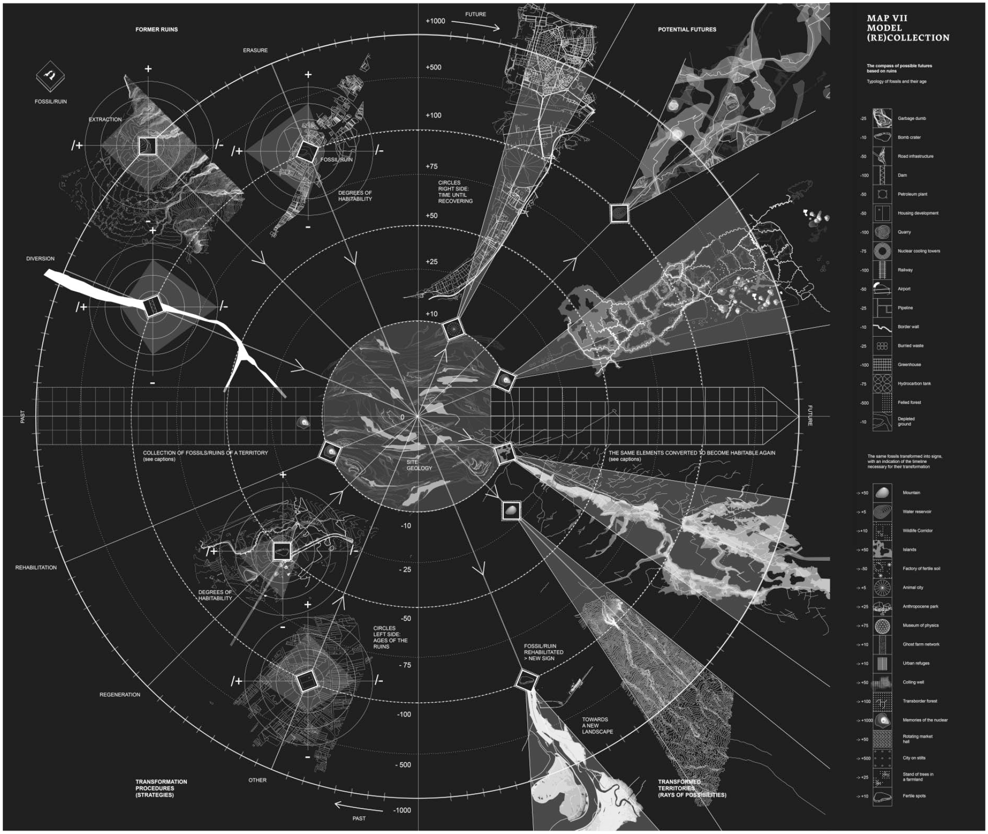
Map. VII (Re)Collection.
Exploring, Sensing, and Visualizing the School Building as a Terrestrial Space
Our ethnographic project applied these design principles and cartographic experiments, extending their relevance beyond the process of architectural planning, to focus on the continued life of post-pandemic school buildings. The ethnographic work was organized across two phases, each 5 months in duration. In Phase 1, we interviewed staff and developed workshops and discussions with a group of 14 students (16 year olds). We used school blueprints during the interviews as well as walking tours, to begin to understand how participants connected with specific spaces and conventional maps of the building. The workshops involved experimental situations with sensor technologies and an engagement with spatial problematics like those of perspective, atmosphere and envelop, trajectory and movement, threshold and flow, sound and air. The data generated included video, sound, photographs, artifacts, and text. Phase 2 continued with workshop activities, creating new data during various futuring practices which sometimes included images and models derived from Phase 1 data.
A central aim of the workshops was to transform and enrich students’ spatial imagination through experiments that intensified embodied action and sensation in the school building. Due to our focus on the Terrestrial, we invested in experiments that pushed spatial experience beyond anthropocentric frames and opened more imaginative ways of inhabiting complex environments (Latour, 2005). More specifically, we were interested in the multiplicity of emotions and sensations fuelling the atmosphere in the post-pandemic school building. Many of these circulate under the threshold of human perceptibility (Fuller & Weizman, 2021) and were pre-conscious or pre-personal (Massumi, 2002). Our aim was to design experiments for sensing the architecture so that the building atmosphere might become visible and tangible in concrete visual maps and models. We used sensor technologies (cameras, air sensors, sound recorders, iPads) and software (Procreate, Flow, Polycam, Hyperspektiv, Outdooractive, Quik, Autocad, Reshoot 360) to move with students as they explored familiar spaces. This technology and software was especially fruitful for “sensing” the different kinds of agencies distributed across the school building. The ethnography rendered the more-than-human relationality visible but also highlighted the provisionality of the built environment and current spatio-temporal compositions, revealing new aspects of transindividual life in the building.
In one of the initial workshops, we explored the problematic of perspective and architecture. We experimented with a GoPro Max camera and the software Reshoot 360 for iPad 2020 to generate 360 images of school spaces chosen by the students. Playing with the combination of camera and software, students were able to bend and distort the rectilinear walls, floors, desks, and seats, thereby recomposing the space according to circular, concave, and convex geometries. In another workshop, we grappled with the problematic of atmosphere and envelope. Students used light detection and ranging (LiDAR) scanners to feel the interior skin of the building, mapping the architectural envelop (Carpo, 2017). Scanning the space as a 3D volume demanded that students move slowly and carefully along walls and into corners and transformed key rooms into glitchy digital boxes that could be examined as 3D models on the iPads, using Polycam software (see de Freitas & Trafí-Prats, 2023). The resulting ragged and imperfect but also hyperrealist 3D models generated with the app Polycam raised students’ curiosity. Students talked about the queer perspectives onto the doll house 3D images afforded through jagged openings in the digital model. This also triggered a discussion about their own hypervisibility in the school and the absence of spaces where they might not be seen by others. This part of the digital ethnography provoked some students to imagine ways to escape (LiDAR) vision (see de Freitas & Trafí-Prats, 2023, for more on this).
In another workshop, we explored the problematic of trajectory and flow in the building. For this, we used some images of spaces that we had previously solarized in Photoshop to make them appear as line sketches. We uploaded these images to the app Procreate, which is widely used for digital painting and illustration and invited students to trace their daily itineraries. In other workshops, we explored flow and daily trajectories, both to the school and within the school. Students drew their daily journey to school on blank maps of the region. We taught the students some basic features of the Procreate app and how to use the Apple Pencil so they could draw various lines over a given image or map of the school space, depicting the movement of bodies. We showed them how to record and compile the layers of drawn lines into a video file, showing how trajectories unfolded and overlapped across the map over time. These trajectory maps were gestural and tentative, capturing their spontaneous hand movements as they simultaneously observed the space and recorded their observations. In all the fieldwork, students acted as privileged informants and data creators, who revealed key aspects of their lived experience.
A series of workshops investigated the school building using artist and designer Ling Tan’s SUPERPOWER app 1 installed in students’ phones. The app allowed students to map spaces in the building by integrating a rating scale of good-bad spaces, photographs, texts, and geolocation related to the school floorplan. The collectively generated data revealed six extremely important spaces, associated with concerns and intense emotions—the sixth form hub, 2 the sixth form study room, the main stairs, the atrium, and the atrium’s void. Furthermore, Tan led the students in creating conceptual cardboard prototypes that imaginatively responded to the collected data and incorporated possible improvements. Many of the prototypes, and more of especially those concerned with the transformation of the sixth form hub, the study room, and the atrium’s void, demonstrated a repeated interest in creating interior spaces to intensify small-group sociality, using things like circular sitting pods, higher walls, curtains, and stand-alone pavilions. Other prototypes altered the architecture for new kinds of mobility. For instance, one of the prototypes proposed to add a slide to the main stairs “for moments of the day when one wants to let go.” Another one incorporated some trampolines in the sixth form hub as a way of having “something playful” yet regretting that “they won’t be allowed because of safety.” Some designs made explicit how dwelling in certain spaces was debilitating, due to the hardness of the furniture and “with no space where to be and talk,” referring not only to the lack of space to hang out but also to the impossibility of hearing each other in the open atrium where noise had become a significant school problem. Different designs noted the “flatness” and “dullness” of spaces in the building, suggesting the use of plants in the atrium, the painting of some walls in warmer colors, and the opening of windows in the study room. The cardboard prototypes helped to show how the students’ relationship with the building involved a complex mixture of affective forces and pragmatic constraints pertaining to mobility, visibility, and atmosphere. 3
The School Building Living Map
We discuss in detail here The School Building Living Map (Figure 2) which was designed to incorporate diverse datasets, including interview data with teachers and staff, discussion data from student workshops, and other observation field data during the ethnography. Compiling this data into one visualization was incredibly challenging and involved using many of the creative mapping techniques developed by Aït-Touati et al. (2022) and more particularly in the “Living Landscapes Model” (pp. 98–119). The map utilizes a visual token from the BDP blueprints—that being the bracket shape—and layers various kinds of coded behavior onto it. The four brackets demarcate each of the four floors, which are color-coded to match the differently colored walls of each floor. The map also includes the outline of the main elements built around the open atrium space (theater, offices, main stairs). The map makes visible a palimpsest of accumulated layers of activity organized in temporal refrains that were seen to repeat daily. Different from the standard architectural cross-sectional drawing which separates activities, assigning each to a particular floor, the map shows all four floors overlayed, superimposing multiple layers of activity in ways that are impossible, and yet actual. This alternative approach was chosen to better show how the open space atrium made these different activities visible and open to surveillance, while also acting as the key void in the interior of the school, a space for imagining escape from containment, as well as different kinds of mobilities.
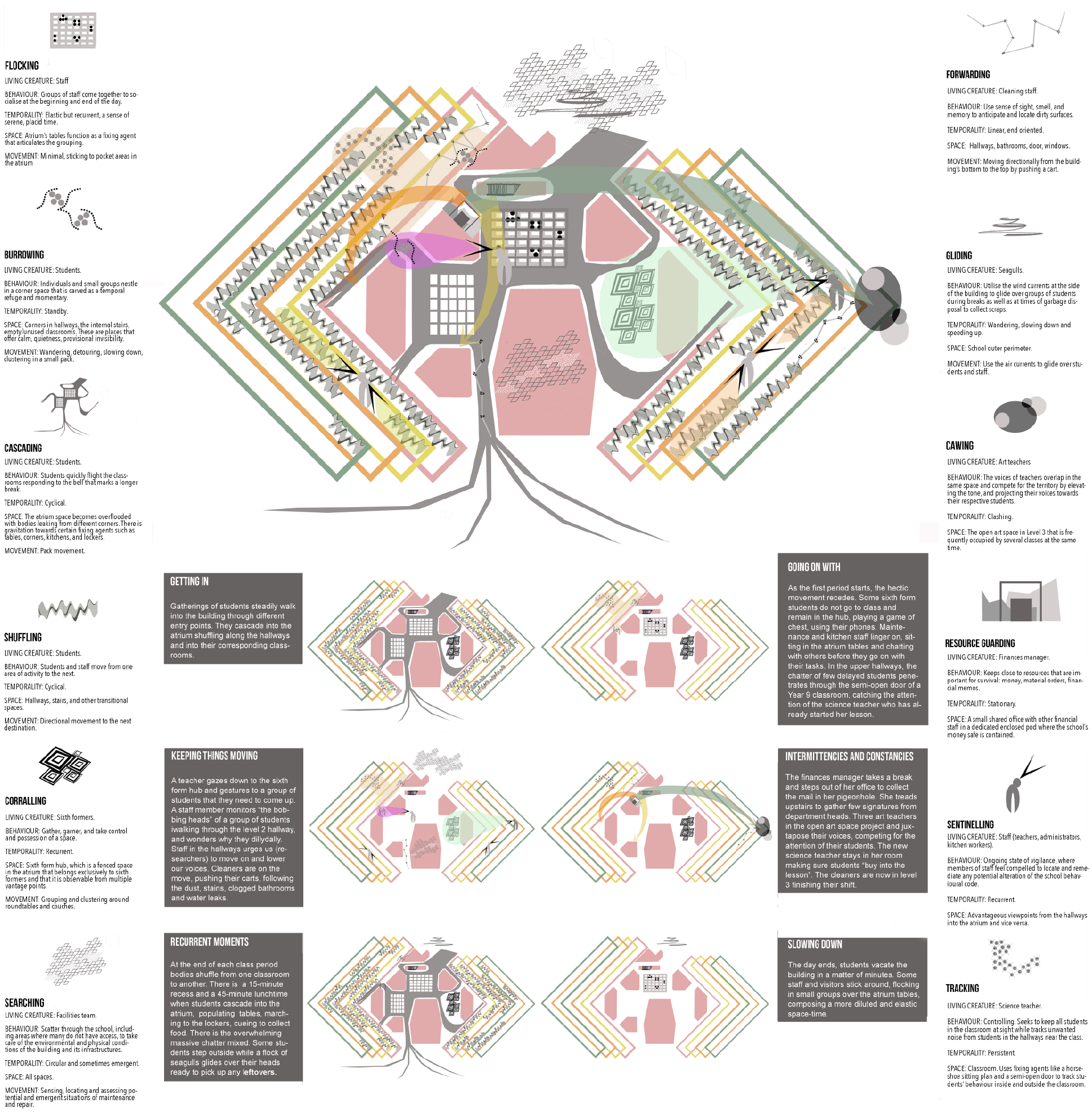
The School Building Living Map.
After reviewing all the data, we identified 12 ephemeral behaviors and spatial practices that together produced the living space in the course of any one day. Each behavior is locational and tagged to a particular part of the school, as well as being associated with specific agents. Following Aït-Touati et al. (2022), we characterized these social practices in terms of physical activities that are used by animals when negotiating an environment. Their names are meant to evoke the kinds of embodied activities that might be represented in a description of a complex ecology where different species interact, each habituated to its own activity. These are flocking, where at the beginning and end of the day, staff meet and socialize around the large tables in the atrium which act as a fixing agent; burrowing, where groups of students nestle in corner spaces outside the classroom using them as temporary refuge; cascading, where large numbers of students leave the classrooms and flood the atrium; shuffling, where students and staff travel to the next activity at the end of a period; corralling, where a group of students gather and take control of a parcel of space, like the sixth form hub; searching, where the facilities staff scatter through areas of the school as maintenance is needed; sweeping, where the cleaning staff moves linearly and continuously from the lower to the upper floors locating and removing dirt; gliding, where groups of seagulls fly outside waiting to collect student food scraps; cawing, where various teachers raise their voices to compete for attention in open classroom spaces; resource guarding, where staff from the finance department remain in place to guard the school’s safe; sentinelling, where staff use vantage points in the open atrium to remain in a constant state of vigilance; and tracking, where teachers use architectural features like semi-open doors to track student behavior inside and outside the classroom.
The School Building Living Map presents a map that is descriptive, inscriptive, and generative (Dortdivanlioglu, 2018). The map is descriptive and inscriptive in the sense that it displays a concrete organization of actants and their activities, attending to daily normative habits that we can call “inscriptive.” The map is a dynamic diagram of how these 12 kinds of behavior constituted a living landscape that materializes practices of control, escape, refuge, delay, crowding, flow, vanishing, dissipation, and so on. The map is also generative because the process of layering and connecting the 12 behaviors effectively produces a landscape with depth and complexity, a multiple school much like Latour’s multiple earth, co-produced through behaviors that are sometimes at the level of governance while more often are at the level of minor gestures. These behaviors have been concatenated in the map into six explicitations that show how behaviors compose with other behaviors at different moments of the day. These six groupings are offered as examples of how particular kinds of temporal junctures—the end of class, for example—trigger a set of activities, which bring different kinds of actants together. The living map is temporal in showing how the life of the building unfolds in daily itineraries and activities, which are brought together at particular moments in time. The map also materializes a Terrestrial multiple school, revealing the micro-territories that emerge as part of the political ecology. As such, this map fosters new understandings of how common space is formed in the school building and visualizes the ways in which activities are interdependent and co-constitutive of common spaces. In making explicit the new social-material topology of school space, the map exposes some of the tensions and conflicts that emerge among different agents in the overlapping layers. It reveals the ways that certain behaviors are convergent, while others are divergent and contribute to an agitated atmosphere.
Speculative Models Using 3D Software
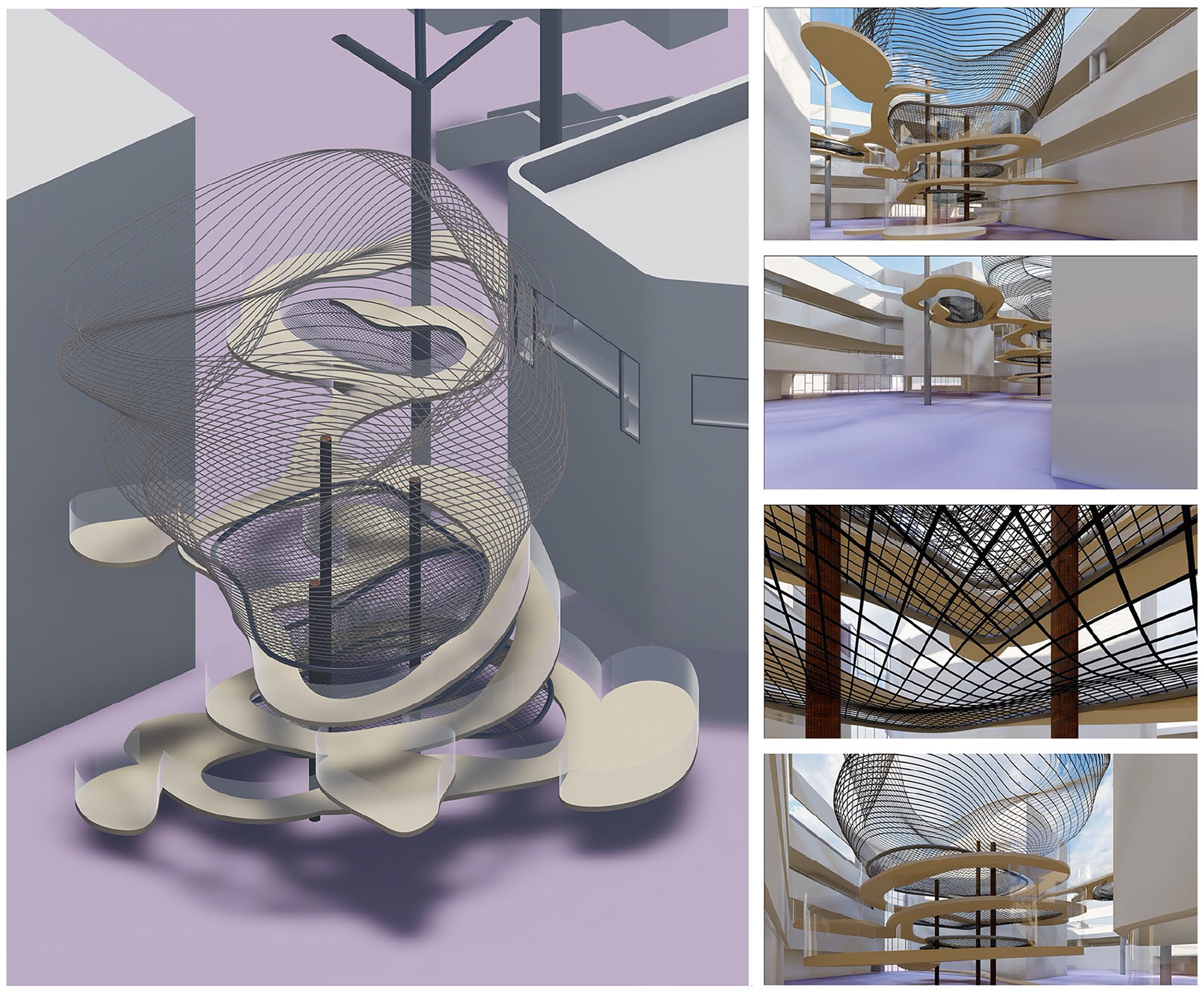
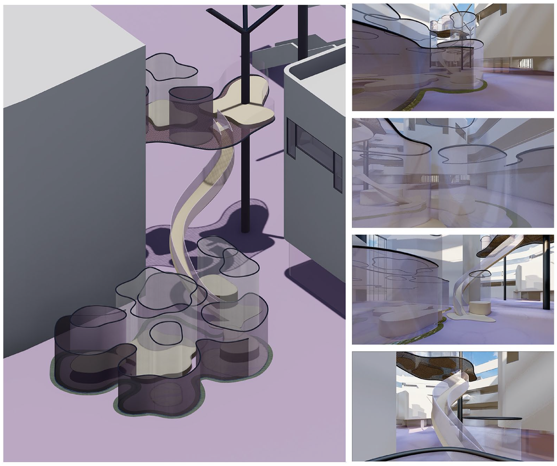
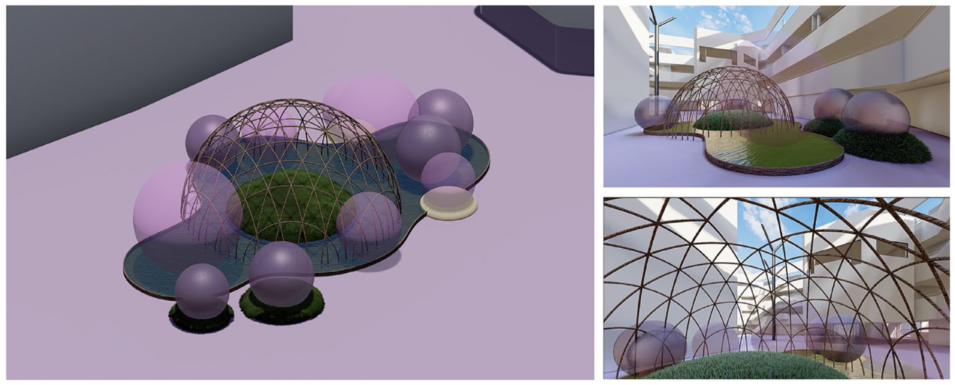
After identifying salient features of student maps, models, and other futuring practices during the workshops and correlating these to ethnographic and observational data, we were able to modify existing architectural plans and build 3D models of the lived school building using CAD software. We exploited the possibilities that the CAD software offers to set any digital model into continued variation (Carpo, 2017), allowing us to modify the models as we continued to review our data, while offering an important mode of spatial analysis that attends to the relationality of the built environment and therefore the ways in which our students were implicated in a “whole” space of interconnected agents (Ghosn & Jazairy, 2019). These five models synthesized student data on affect and spatial sense and appealed to the workshop futuring practices and speculative mapping and modeling techniques we cited earlier. We named the five models: The archimedea (Figure 3), The wormhole (Figure 4), The seagull’s swooping circular path (Figure 5), The draped lily pads (Figure 6), and The bubble (Figure 7).
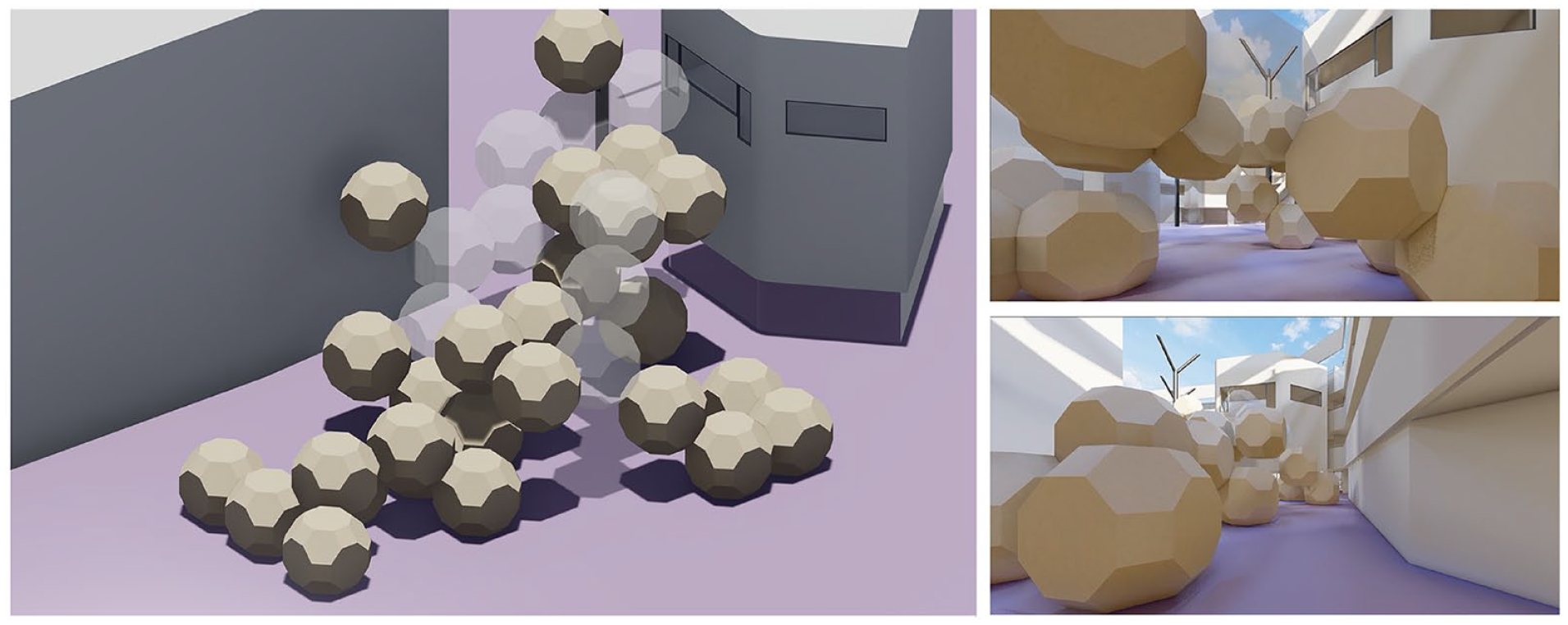
The Archimedea.
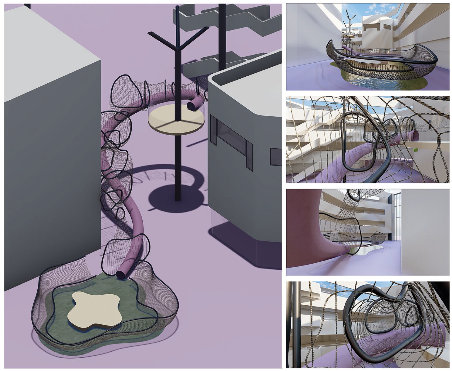
The Wormhole.
The Seagull’s Swooping Circular Path.
The Draped Lily Pads.
The Bubble.
The Archimedea consists of stacked polyhedral forms (Rhombicuboctahedra) which seem to grow with torsion and detach as they rise up in the atrium, from the ground floor to the second floor (Figure 3). This strange aggregate form resembles a complex molecule, perhaps composed of viral particles chemically fused or linked, some transparent and ghost like, offering a viral passage between key locations in the school. This model involves individuated pods assembled together into a precarious discontinuous structure, much like the student body as it re-assembled itself after the pandemic. The corridors and open spaces appear littered with the polyhedra, cluttering, and filling the space, functioning both as a new mode of occupation but also as obstacles countervailing previous forms of mobility. The model reflects the post-Covid environment in which this research occurred, where the mobility of the students was radically reconceptualized in terms of unusual highly scripted navigations, evoking new postures and movements such as hunching, avoiding, and masking. This model also speaks to students’ wish for other geometries and structures and emphasizes the play of Euclidean constraint on the environment. As such, the design poses multiple questions about students’ sense of their co-habitation and connectivity in this postpandemic space.
The wormhole model explores ideas of meandering, indirect or inefficient movements. In this case, the transit from the sixth form hub (atrium) up to the platform (second floor) is through a stretchy see-through netted tunnel that twists across the atrium’s void (Figure 4). The title of wormhole is in reference to an astrophysics concept that refers to links between two different points in space time, creating a shortcut that could reduce travel time and distance. The concept is found in science fiction, where travelers can move from one world to another, without having to follow the usual rules of motion, but also in solutions to Einstein’s theory of general relativity. The wormhole speaks to the students’ wish to be in their two preferred spaces without having to traverse territories that feel dangerous. If the students can travel in these wormholes, they can avoid the exposed staircases that flank the atrium and are part of the panoptic architecture of the school building. They can occupy these two spaces linked by a positive affect and move back and forth, without risking exposure to the forces that cause them anxiety. The model embodies these ideas in various ways, as the tunnel narrows considerably at different points and makes passage difficult although not impossible because the fiber is flexible and expands. Evoking a science-fiction imaginary, the wormhole is a way of escaping space-time trappings and traveling into higher-dimensional spaces, introducing a dramatic change in location, and the journey is felt through the vibration of the net, rather than through the eyes and their perspectival tendencies (and associated panopticon capacities), as bodies move from one end to another. Running adjacent to the netted tunnel, there is a narrow tubular slide made of a rigid, opaque, smooth material. The movement on the slide contrasts with the movement through the wormhole because it operates through conventional Newtonian mass, so that bodies speed up with gravity as they descend, reflecting students’ desire for an embodied feel of exhilaration and “letting go.” The model resonates with the work of Studio Tomás Saraceno and their exploration of a politics of space through the making of alternative webbed models of transit and communication (Galantino & Coccia, 2020).
The seagull’s swooping circular path also reveals alternative mobilities in the school. It is composed of a rambling ramp that conjures the swooping circular paths of the seagulls flying near the school building (Figure 5). Here the nets are more expansive and allow for nesting or perching, along with the resting platforms. The ramp is entirely disorienting and continues the focus on inefficient and indirect movement and complicates the visual perspectives on the surrounding of the atrium. In addition, the ramp slopes and angles inwards, making movement precarious but exciting and challenging balance. The net also requires crawling, jumping, and bouncing, decentring the image of bipedal man and grid-controlled movements. It also plays with possibilities of drifting and being suspended in the air.
The draped lily pads are made of curtained spaces that can be opened and closed. Curtains were proposed by the students in their prototypes and mappings, to create smaller private spaces within the shared space of the atrium (Figure 6). The drapery hangs from mechanical rails and has different opacities creating a fluid, soft, and metamorphosing perimeter. The name “lily pads” refers to the students’ interest in draped areas surrounded by moats of water, here visualized as rings of water that isolate, protect, and delimit the sixth-form hub from other atrium occupants and passers-by. Both curtains and moats offer radically different textures (soft, velvety, moist, fluid) to the school building and change the haptic nature of its surfaces. Students spoke of how the sounds of the curtains opening and closing and the water moving would increase the affective-sensory nature of the model, demarcating the area through its own soundscape. Like other models, these lily pads offered an alternative within a space that addressed students in terms of being “ready to learn” and a “school citizen,” offering a dreamlike space where they might “take a break,” “relax,” “let go,” “hang out with friends,” and “be by yourself.”
The bubble model incorporates translucent and transparent bubbles of inflated plastic, amplifying the fantastical references to waterfalls, steppingstones, and grass in student data (Figure 7). These fantastical references came forth in the workshops, alongside the expressions of anxiety, precarity, vulnerability, and awareness of interdependence. Bubble reveals a controlled sociality of shared air and breath. Through constant curvature, The bubble shows that the school was a space both of containment and captivation, as a kind of lockdown during the pandemic. The open air of the atrium is entirely rejected in this model, representing the force of government regulatory interventions to moderate and manage toxic air quality, under spherical containment.
The five models draw from SF imaginaries (Haraway, 2013) as a way of thinking with the limitations and possibilities of school space. They can function as a springboard for discussing the ways in which learning environments figure in the lives of students and how the school building is “more contingent than it is presented to be,” and thus, the models “demonstrated and proved that the world in which we live is neither necessary nor complete” (Lecompte, 2020, p. 168). Indeed, they make visible experiences of the school building where space is neither a fixed geometry nor the background in which bodies undertake actions but is carried, moved, and extended through inhabitation and improvisation (Enderby, 2022). They deploy visualizations that allow viewers to imagine the perils of navigating the current environment and possible ways of intervening in the school building to address its affective shape (Ghosn & Jazairy, 2019). They perform a “tragicomic perspective” (Anker & Anker, 2019, p. 210) in which actual accounts about noteworthy social, affective, and environmental issues affecting life in the building repeatedly evoked by the students are addressed with creativity, humor, and imagination. We thus approach school architectures from within their complex unfolding (Latour, 2018), making explicit various implicit structures that were not visible prior to the research, revealing the fluid space between what it is and what is possible (Halse & Boffi, 2016), so that others can discuss local adjustments that support their own scenarios of how and why to imagine and create other school architectures.
Conclusions
Our maps and models demonstrate how the complex social-material ecology of post-pandemic school space emerges through various modes of real and imagined engagement. Our focus has been the emotional impact of the pandemic, as it implicitly and explicitly shaped fears and desires about proximity, mobility, and inhabitation. Students’ spatial practices underwent radical transformations; their schools became increasingly about surveillance, their bodies treated as viral vectors. These speculative renderings of our data explicitly avoid resolving multiple disjunctions and tensions, letting the anxieties, sensitivities, and disparate modes of attention come to the fore. As such, the maps and models show that difference rather than uniformity is what makes the common of school space. Latour (2005) argues that in such a heterogenous political ecology, the common is not given but needs to be composed. He adds that such composition is only possible if we become “interested in differences that seek what they have in common” (p. 220). Following this ethos, our collaborative digital-sensory ethnography worked with the idea that there is no common “without practices that entangle people” (Stengers, 2023, p. 179). Thus, we collaborated with students and staff in enacting experimental practices of exploring and sensing habitual school spaces. But we also understood that such commoning already involved both the technical and the more-than-human factors. We showed students how to make visible the alien sensitivities of sensor technologies and software to conjure the pre-personal, atmospheric, affective, and animal dimension of spatial life in schools. We have called these futuring practices because they intensify the potential for re-imagining and re-shaping the school building.
In alignment with the work of contemporary architects, artists, and designers, we have argued that speculative spatial methods allow us to share research findings in visual modes. The data have been “written up” in maps and models. This entails describing space anew as a complex, multiple, open-ended, Terrestrial actor, while imagining it beyond the tropes of realism, optimization, and determinism that habitually frame the discourse on school buildings. Thus, the School Building Living Map connected locational behaviors of different actants and overlayed them to visualize daily space-time refrains. We pursued an alternative representation of the building that mattered the space differently, drawing attention to micro-territories, interdependencies, tensions, and various forms of common life that emerged. Similarly, the inherent potential for variation of the CAD software allowed us to transform the designs so that they might better evoke the spatial relational ecology, as we continued reviewing our data and discussed the ideas with the students. Both processes effectively foregrounded the potential of speculative thinking, cultivating an approach to architecture and the built environment that was responsibly future oriented.
Finally, this project has raised new questions about how architecture might become more responsive to our changing social-material conditions, as ecological crises and issues of spatial injustice proliferate. How might these kinds of speculative experiments help us formulate new modes of earthbound inhabitation and change our spatial practices and modes of belonging? In such imagined futures, who will be able to participate in these altered earthly compositions? Which sensitivities will be solicited and which will go undeveloped? How will researchers attend adequately to the emotional, cognitive, and affective dissonances proliferating in these learning ecologies? Following Latour, how might we support a more inclusive relational ecology, honoring and engaging with the metamorphic Terrestrial through technical, speculative, and responsible modes of commoning?
Footnotes
Acknowledgements
We express our gratitude to Albena Yaneva (Manchester University) and Benjamin Blackwell (Manchester University), members of the project’s team, who reviewed and discussed earlier drafts of this article. We thank Izzy McCauley (Manchester Metropolitan University) for her technical knowledge and design sensitivity, which was instrumental in elevating the creation of the 3D models to a professional level. We also recognize our partner school and, more specifically, the staff and students who participated in the activities and contributed to the maps and models discussed in the article.
Declaration of Conflicting Interests
The author(s) declared no potential conflicts of interest with respect to the research, authorship, and/or publication of this article.
Funding
The author(s) disclosed receipt of the following financial support for the research, authorship, and/or publication of this article: This article is an outcome of the research project, Mapping spatial practices and social distancing in smart schools: Sensory and digital ethnographic methods: ES/V006436/1, funded by UKRI’s Economic and Social Research Council as part of the Transformative Methods Call 2021–2023.