
Abstract
Recent research at Great Zimbabwe (1100–1750
Introduction
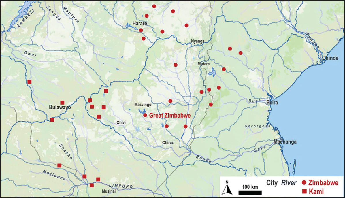
Great Zimbabwe lies in the south-central parts of the Zimbabwe escarpment (20o16’ 22.64” S, 30o 56’ 2” E, 1,150–1,250 metres above sea level) of southern Africa (Figure 1). The hills on which this ancient city is located comprise several micro-watersheds, drained by rills, gullies, streams and small rivers, which ultimately join the Mutirikwe and Tugwi rivers. These rivers flow south-eastwards into the Runde River, which in turn joins the Indian Ocean–bound Save River. The associated landscape is characterised by whaleback granodiorite hills, which are part of the Zimbabwe Craton, which comprises Archaean, crystalline plutonic rocks such as the magma-derived granites and recrystallised or deformed metamorphic rocks such as gneisses (3.6–2.4 billion years old).
1
The weathering qualities of granodiorite rock have been exploited since the early second millennium
This article seeks to understand the connections between water storage facilities at Great Zimbabwe and the crystalline geological context of the surrounding landscape. Data used for this article are derived from the geoarchaeological investigations conducted at the site in July 2017. Apart from archaeological excavations to determine the status of some settlements located on the periphery of the core monumental structures,
3
a survey was conducted to understand the hydrological context and water resources of Great Zimbabwe. Preliminary results from ALS/LiDAR scanning are also presented to understand the sub-surface water resources the residents at Great Zimbabwe may have had access to. This followed an earlier scoping study on water resources in Great Zimbabwe.
4
This research seeks to engage with ongoing hydrogeological studies on crystalline rock formations in other parts of the world
5
and to understand how Great Zimbabwe may have functioned as an urban society during the first millennium
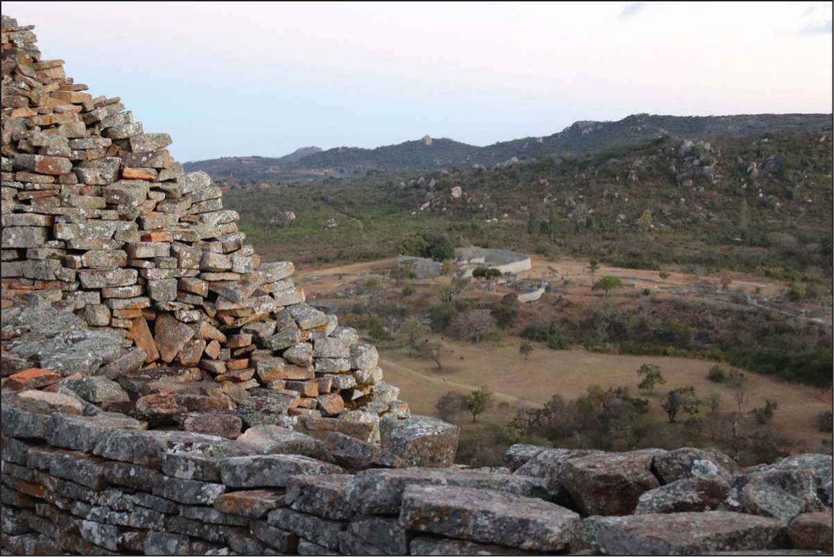
Great Zimbabwe (Figure 2) is identified in early archaeological literature as a medieval age,
6
only because its imported artefacts largely date to that period and not because of any connections with Medieval Europe. Radiocarbon dates the settlement from the eleventh to the eighteenth centuries
A View of Great Zimbabwe from the Hill Complex, Showing the Great Enclosure and the Valley Complexes.
This article is framed within the general hydrogeologic context of basement rocks. The methodology attempts a characterisation of the granite landscape around Great Zimbabwe to understand its water resources and uses soil profile sampling to understand developments within basement rocks and how Great Zimbabwe residents exploited them for water. The ethnographic mapping of water resources highlights local worldviews on how granite is linked to water. Airborne laser scanning (ALS)/LiDAR scans reveal the stream channel network and potential storage capacity of the underlying basin. Results suggest that Great Zimbabwe was built on an aquifer. The conclusion focuses on groundwater in basement aquifers and its sustainable storage and management for the continuation of Great Zimbabwe.
Geohydrological Contexts of Crystalline Rocks
Crystalline basement rocks comprise hard, igneous or metamorphic rocks such as granites, basalts, metaquartzites or gneisses with negligible primary porosity and permeability. 9 Formed several kilometres deep into the earth’s crust and exposed to the surface due to erosion, crystalline rock outcrops are in numerous locations in southern Africa. On the Zimbabwe plateau, they are the most dominant rock formations. Potential composite or weathered-fractured rock aquifers are developed within their weathered overburden. 10
Crystalline rocks have a distinct weathering profile, 11 which contains overlying unconsolidated material derived from the prolonged in-situ decomposition of bedrock (regolith), measuring a few up to several metres thick. In sub-Saharan and tropical Africa where weathering is pronounced, the regolith is thick. However, in arid terrains lacking surface water resources, a thinner weathered overburden is present. The overburden has a high porosity and a low permeability due to the clay-rich inclusions in the regolith and, when saturated, constitutes the reservoir of the aquifer. 12 Because it is highly porous, the regolith zone acts as a reservoir that slowly feeds water downward into fractured bedrock. Profile fracture density decreases with depth and so does the porosity of the weathered profile. High permeability occurs between the fresh fracturing rock and the regolith. 13 Sub-surface water productivity relies on the presence of weathered material overlying the fractured rock or an alternative source of recharge. 14 Crystalline basement aquifers are located on a continuum between porous unconsolidated weathered layers and channel systems, where the groundwater flows and is stored in the aquifer matrix, in between these. 15
Research during the past two decades or so on the hydrological qualities of crystalline rocks indicates that they have medium to low permeability and thus contain aquifers with modest water resources, compared to porous, karst or volcanic aquifers. 16 Due to their low porosity, granites are generally poor aquifers but do make good aquifers if their sub-surface horizons are highly fractured. Where crystalline rocks have exceptionally very high flows, they can significantly contribute towards the supply of drinking water to cities of several tens of thousands of people. 17 In semi-arid regions such as sub-Saharan Africa, which are both economically and physically water scarce, 18 groundwater from crystalline contexts is particularly treasured, as it is a source of fresh drinking water, which is also vital for agriculture. Sometimes, groundwater may be the only water resource available to a population and, in such cases, is accessible through digging of wells or drilling of boreholes. Such groundwater is also well-distributed geographically and accessible near places of consumption, such as villages, towns and even large cities. 19
In crystalline regions of sub-Saharan Africa, groundwater emerges on the surface mainly through springs, which are points of exit where water flows from an aquifer. This water is then captured in one way or the other, for example, when it flows and accumulates in pools and other contexts such as swamps or wetlands. 20 In most crystalline environments, however, the water emerges from the sub-surface seasonally, when the water table is high. Wells are normally dug to capture this water.
Due to the low porosity and poor permeability of granite and other crystalline rocks, 21 the bulk of flowing water ends up infiltrated in the sub-surface, where it undergoes ionisation, triggering processes that alter the mineralogical composition of the rocks. Basement rocks are particularly sensitive to these processes since minerals such as biotite increase in volume, generating stresses within the rock, which result in microfractures and then fractures. This further triggers a process of alteration within the rocks, several tens of metres thick, where such rocks are porous and permeable and therefore aquiferous. This process, which may take several millions of years old to unfold, results in an alteration profile, comprising laterite, saprolites and deeper fractured zones. Here, the original rock is completely altered into clay or sandy clay, which is not very permeable, and of relative porosity. Such contexts contain water. 22 According to Lachassagne, 23 one cubic metre of such alteration profile contains 10–100 litres of water, and for a thickness of 30 metres, there are 300–3,000 litres of water under each square metre. This part of the alteration profile provides groundwater storage. It is the permeability of the rock within the alteration profile that allows groundwater to flow. Wells that intersect one or more such permeable fractures have exploitable flows with significantly high yields. 24 The same applies to boreholes, where specific rock types determine variation in their yields. Here, faults, fracture zones and dykes play a significant role and are key in targeting sources of groundwater in crystalline contexts. 25
Guided by this background knowledge, I establish the connections between water storage and harvesting facilities at Great Zimbabwe and the broader crystalline geological context in which the ancient city is located.
Methodology
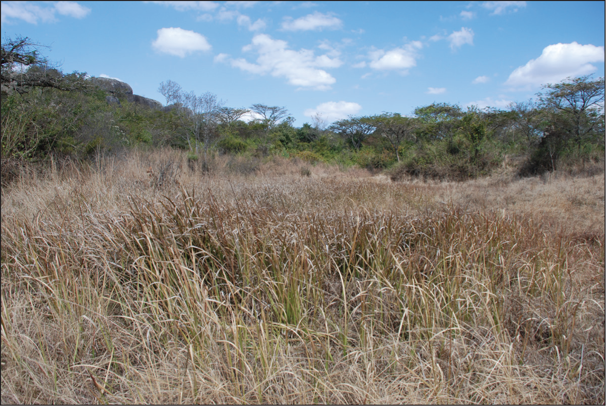
Current research at Great Zimbabwe seeks to understand the development and demise of ancient complex societies in sub-Saharan Africa. 26 In 2016, an article in the journal Wires Water demonstrated that the depressions found within the ancient city of Great Zimbabwe today, sometimes referred to as dhaka (clay) pits (Figure 3), were also used by its residents as water reservoirs. 27 To understand the relationship between these features and the immediate granite landscape of Great Zimbabwe, a geoarchaeological investigation was conducted. 28 Multi-methodological approaches were employed to understand not only how the natural resources within the site territory of Great Zimbabwe were exploited for granite used in the construction of the stone structures, but also how the associated landscape was a water resource. Apart from surveys to understand the layout of the landforms around Great Zimbabwe, soil sampling was conducted to determine the nature of sub-surface soil horizons and their water storage potential. ALS was conducted not only to map the nature and extent of the stone-walled and other built environments at Great Zimbabwe but also to detect how the various landforms were integrated with the site. The following subsections describe the research methods used in more detail.
Dhaka Pits Located on the Western Foot of the Hill Complex at Great Zimbabwe.
Landform Characterisation
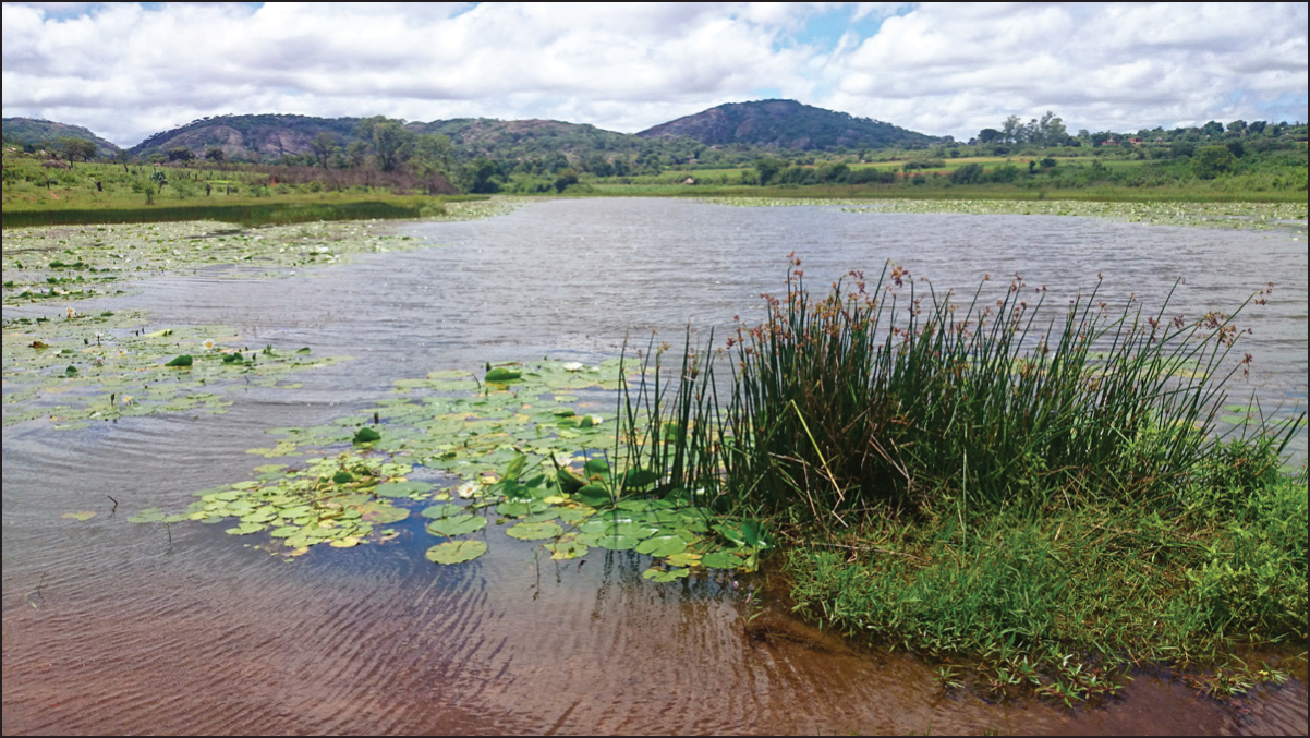
Mapping of the landforms around Great Zimbabwe was conducted using a combination of desktop research, foot surveys and remote sensing data. These approaches 29 were aimed towards the accurate depiction and interpretation of landforms immediately around the stone structures. Where it was deemed necessary to understand certain landforms such as hills and valleys, surveys were extended within a 5–10-kilometre radius from Great Zimbabwe. This also allowed the mapping of hydrological contexts and water resources of Great Zimbabwe, documenting water bodies, particularly springs and streams (Figure 4). This entails a description of the local landscape settings (topography, vegetation cover, land use, etc.) and informal interviews with local communities to gather information on past and current uses of water.
Streams and Springs Within the Site Territory of Great Zimbabwe.
Soil Sampling
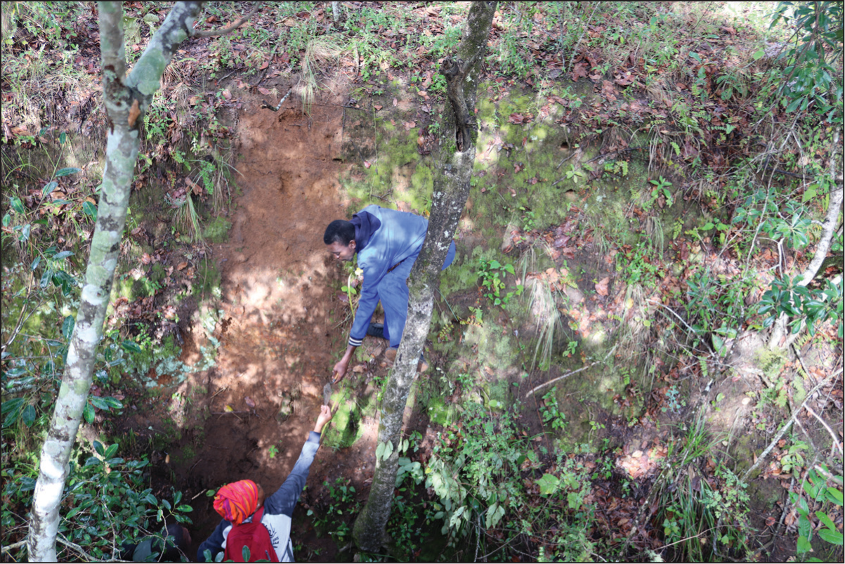
While Great Zimbabwe is a ‘granite landscape’, the characterisation of its soils and sub-surface geological contexts, remains poorly understood. To understand anthropogenic modifications within its territory over time, as well as appreciate its hydropedology, 30 soil sequences were recorded on exposed profiles and using exploratory test trenches. Where deep gullies existed, their vertical profiles were cleaned and sequences recorded (Figure 5). Such sections appeared along the Chisikana stream, flowing northwards from the stone-built complexes, and within deep gullies to the east, eroding towards the Muetero river. In addition, two test pits were sunk to investigate the sequence of dhaka pits. Loose soil/sediments were sampled for multi-element chemical and micromorphological analyses. 31
Cleaning Soil Profiles and Recording Sequences Revealed in Deep Gulleys Found East of Great Zimbabwe.
ALS/LiDAR Scanning
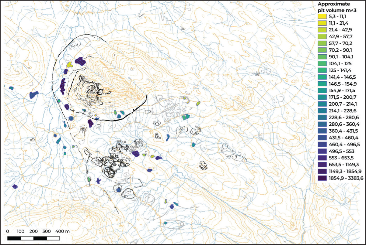
Traditional and modern digital imagery approaches to mapping facilitate the interpretation of landscapes especially the relationships between geomorphology and other landscape variables such as the underlying geology. 32 To map archaeological and hydrological features in Great Zimbabwe and its immediate landscape, an ALS/LiDAR scan was conducted (Figure 6). It is ideal for this purpose as it provides a detailed record of topography and ancient urban areas, 33 even when the ground is obscured by dense vegetation. 34 The mapping produced a Digital Terrain Model (DTM) used to perform surface hydrological analyses, 35 with emphasis on defining catchments and locating closed depressions that could be used to identify probable dhaka pits.
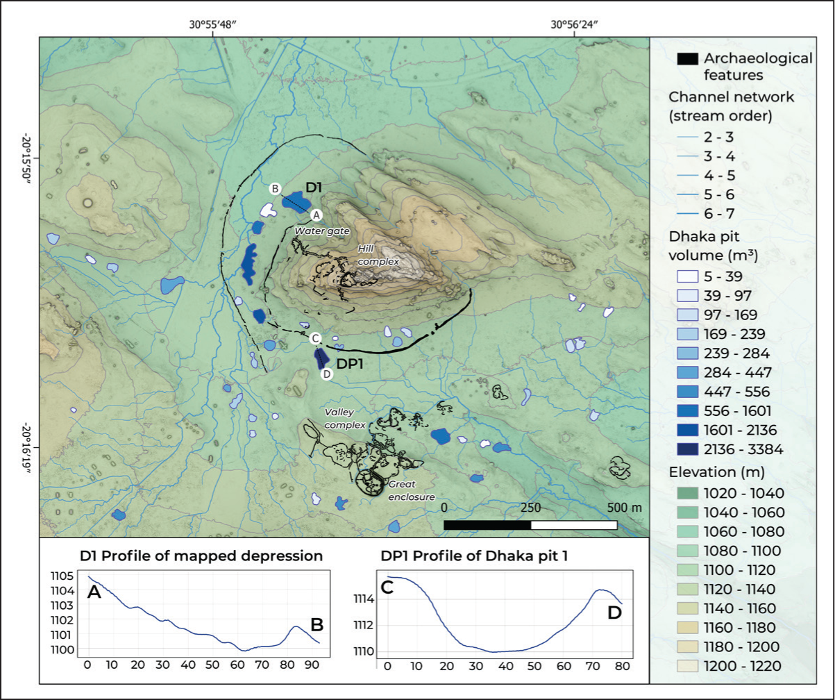
The data from landform characterisation, lidar scanning and soil mapping were integrated with information already acquired from the mapping of water sources around Great Zimbabwe, 36 to determine the relationships between water storage facilities such as dhaka pits and the surrounding granite landforms, and the sub-surface crystalline fractured horizons. Lidar scanning also provided estimates of the amount of water stored in some of the pits. 37
Results
This section presents the fieldwork results, focusing on the character of the landforms around Great Zimbabwe, soil sequencing and sampling, ALS/LiDAR mapping and the water resources.
Great Zimbabwe is located within granite terrain deriving from disintegrated and weathered bedrock below (see Figure 2), which comprises whalebacks (locally termed ruware/maware) and other hills. Whalebacks are solid, largely un-fractured bare rock surfaces, which have resisted both chemical and mechanical weathering as much as possible. 38 The Hill Complex is constructed on a whaleback over 100 metres high. Less than a kilometre to the west of the Hill Complex is a hilly terrain trending north-south, some 30–40 metres high in places, which appears variously as ruware, castle koppies/tors (zvikomo, free-standing rock outcrops) and nubbins. The latter are small hills or boulders rising slightly from the weathered bedrock core. 39 These formations reflect erosion and spheroidal weathering of the squared joint blocks. 40 There are at least three stone enclosures within this range, which have been categorised as ‘peripheral’ since these structures were constructed on the precincts of the main architectural complexes. In all these formations, talus from the mechanical weathering of the parent rock accumulates along the slopes. 41 In between the whalebacks, castle koppies and nubbins are fairly level or gently sloping areas. These attest to the granite bedrock having undergone considerable sub-surface weathering to form soil, through etching or etchplanation. 42 This process takes place at the basal level and on the surface, due to the alteration taking place within the granite. The Great Enclosure and most of the valley enclosures to its immediate north and northeast lie on an etchplain. Another etchplain is located in between the hills to the west, the Great Enclosure and the Hill Complex. The water that floods the base of the Hill Complex to the west generates localised soil developments due to the decomposition of vegetal material. Whalebacks, tors and nubbins, however, are not individual formations as they seemingly are, but are interlinked below etchplains as solid basins.
The soil sampling reported here was conducted within the deep gullies eroding towards Mutero River. Gulley profiles (see Figure 5) give a sense of the development of crystalline context within the sub-surface. Some of these gullies attain a depth of 2 metres in places, the deepest reaching 3–4 metres. The soil profile shows a greyish overburden, which increasingly becomes orange to orange-brown in colour. These are coarse-grained to medium sandy clayey loams, which derive from the weathering of local crystalline rocks. Clayey loams were used in the construction of houses, as seen from the floors excavated in the nearby Chenga enclosure, and must have been quarried from these contexts, as some shallow depressions have also been recorded in the general area. The orange-brown to reddish colouration in the profile is due to their exposure to water.
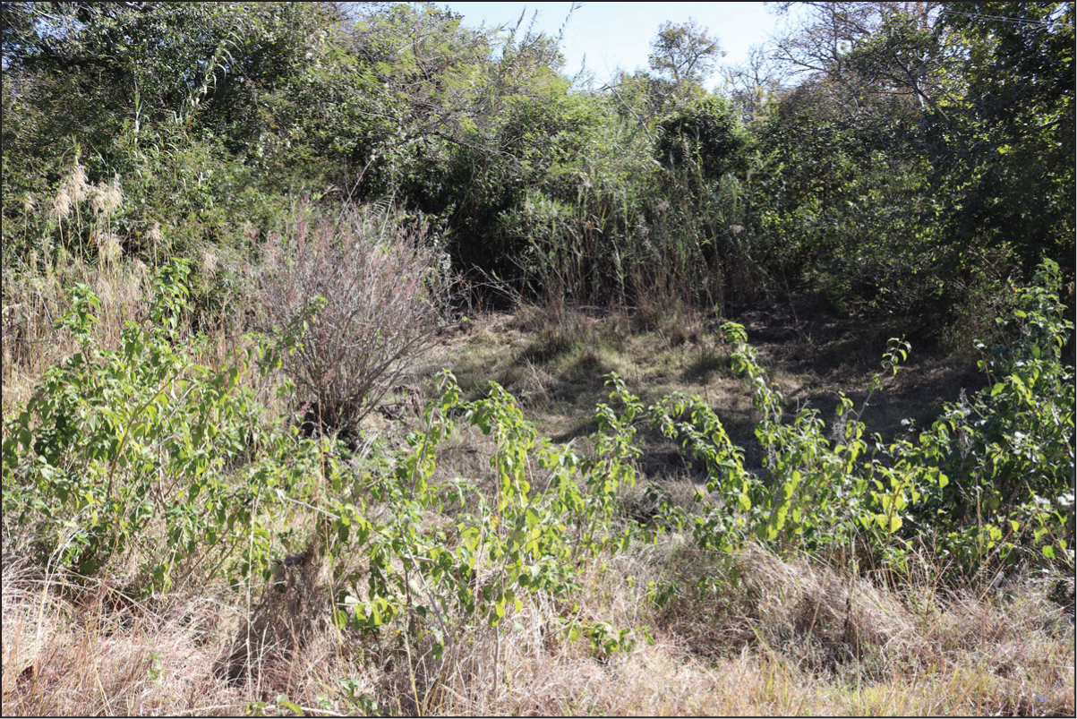
Natural water resources around Great Zimbabwe continue to be utilised by local communities today. Apart from streams and rivers, there are many springs around Great Zimbabwe, with Chisikana Spring, less than 300 metres to the west of the Great Enclosure, being the most significant, both in terms of local clan histories of ownership of the site and water discharge. The spring feeds into a stream flowing northwards to Mutirikwe River, past the western precincts of Hill Complex. Some of its water also gathers as a swamp in the valley below. Water discharge from some of the springs is high, while in others, it is modest or low, with some having dried up completely. 43 Chisikana spring has been negatively impacted by the growth of invasive vegetation (see Figure 7) such as lantana camara as well as European colonial re-landscaping of Great Zimbabwe, which involved growing of Eucalyptus trees to drain areas perceived as ‘swampy’ and create a golf-course.
Chisikana Spring at Great Zimbabwe.
Previous work reported ALS/LiDAR scans revealing the presence of several closed depressions, with some of these corresponding to previously recognised dhaka pits. Some pits have substantial ramparts on their downstream side, which distinguish these features from naturally occurring wetlands, also found in the surrounding landscape. 44 This was a deliberate attempt to dam surface water flow and enlarge the depressions. Here, I report the results of ALS/LiDAR scans as far as they relate to the channel network reconstructed from the DTM. These highlight the drainage of water from the surrounding etchplains as well as the underground water potential of Great Zimbabwe (Figure 8). Connected to the ALS/LiDAR scans are landscape surveys, which reveal details of toponyms and hydronyms, highlighting the importance of water both during the past and in the present. Local traditions indicate that some water sources such as springs such as Chisikana at Great Zimbabwe and pools are owned by specific clans. Rituals and ceremonies regulate such places. There are local understandings around granite and water flow and water storage, as well as how granite is the critical catchment for seasonal and occasional light, mostly winter rains, termed guti. 45
Discussion
The natural fracturing of the granite around Great Zimbabwe was used by its residents to shape rectangular blocks, for building stone structures. Dry stone walling has resulted in unique monumental structures in sub-Saharan Africa. Within the sub-surface below etchplains, the fracturing of such rocks created aquiferous contexts that stored groundwater. Water percolating the soil and subsoil around Great Zimbabwe eventually comes into contact with impervious levels and some of it re-emerges to the surface either as springs or seasonal swamps. Thus, the granite landforms around Great Zimbabwe are important in providing granite as a building resource (stone and clay) and water as a resource. The fairly steep hills dictate a radial drainage pattern, with water from the core monumental complexes flowing outwards in all directions. Due to immediate run-off, the residents of Great Zimbabwe had to store the water required for consumption.
While soil chemical and micromorphological analyses are now being undertaken, gulley profiles to the east of the core monumental complex towards the Mutero River provide local, site-specific sedimentary records of Great Zimbabwe and its immediate landscape and the paedogenesis within the same landscape. The red coarse-grained to medium sandy clayey loam is more like terra rossa soil, which originates from the weathering of granite material. These are typical of granite-dominated landscapes and are very common worldwide. Gulley profiles attest to the process of alteration within basement rocks. Their aquiferous nature is attested by their yielding, containing as well as conveying groundwater. These contexts are, therefore, an important source of water, which moves through the aquifer and resurfaces through springs and wells. These profiles are different from those reported elsewhere at Great Zimbabwe, 46 which point to localised changing soil moisture in the profiles of the dhaka pits and the Chisikana stream section. The latter profile points to a slow energy environment with localised movement of fine material from upslope, gradually aggrading under an open woody savannah vegetation.
This raises questions on aquifer recharge and sustainability. It is difficult to estimate recharge since aquifers are governed by hydraulic conditions between the regolith and bedrock. The water table in the saturated zone of an aquifer is dependent on the amount of rain in a given catchment that infiltrates the sub-surface. Across much of southern Africa where potential evaporation is higher than the average annual rainfall, catchment recharge is not uniform. In very low rainfall regions, it is negligible. 47 At Great Zimbabwe, maware constitutes effective catchments as these provide immediate run-off towards the etchplains. Apart from the normal summer rains, they also receive guti (drizzle) during winter. Sustainability of groundwater is important, 48 since depletion of such a resource may trigger sociopolitical, economic and other consequences. Sustainability should not be confused with ‘safe yield’, which assumes the attainment of a long-term balance between groundwater abstractions and annual, natural recharge. 49 While natural recharge is important in the assessment of sustainability, 50 the complexity of aquifers beyond water balance matters. Since aquifers are in a state of natural long-term equilibrium before water withdrawal, to maintain such equilibrium, groundwater abstractions must be balanced by capture, that is, increased recharge or reduced discharge. 51 Such estimates are not sufficient since it is also necessary to assess how reserves are replenished, usually annually, during the rainy season. 52 Apart from the seasonal rains which generate a recharge of reservoirs through surface flows, some surface run-off and groundwater infiltrate the subsoil. This is a significant amount, ranging from a few per cent to 20%–30%. Given Great Zimbabwe’s limited catchment and water-yield basin, harvesting of water could be enhanced through dhaka pits, since such storage was critical for the ancient. Whether these pits were sustainable remains to be determined. Dhaka pits served as a primary adaptation to an environment that became dry for several months of the year. In the case of the ancient Maya, societies had their versions of landscape-altering infrastructure that used ingenuity to figure out how to sustain large populations in the Yucatan Peninsula region of the Puuc. They became excellent managers of rainwater, using massive systems of cisterns called chultuns to collect and store rainwater in the absence of natural water resources. 53 The already excavated dhaka pits were repurposed for this to cater for the growing needs of the city. The re-digging of the pits was an exercise in exploiting the fractured zones, to capture underground water. The sizes of the pits vary, the largest measuring some 200 × 50 metres across and up to 4 metres deep in places. Given that some of the largest pits stored between 500 and 3,400 cubic metres of water, we can surmise that the discharge rate was sufficiently high to cater for a growing settlement. Its residents found it important to stem the flow of the water to nearby rivers, given the local relief that comprises a radial drainage pattern or network, and the topography, which is quite steep in places.
Managing etchplains within the core monumental complexes at Great Zimbabwe was key in resolving problems such as water run-off or water scarcity. Re-engineering of the landscape through the digging of large to very extensive pits ensured storage of run-off from springs, as well as capturing groundwater channels that comprised the aquifer. This ensured adequate exploitation of groundwater reserves, which are sometimes the only water resource available for the ancient city residents during the dry season. Another re-engineering of the monumental complexes seems to be the construction of what is regarded as perimeter walling. These walls have been interpreted as structures demarcating elite monumental settlements from non-elite structures. On the southern and western sections of the Hill Complex, the walls flank the dhaka pits, and there are no settlement remains inside them. The inner perimeter wall runs from the eastern foot of the Hill Complex around to the south and west and stops just past a cluster of stone structures referred to as the Watergate, where the western ascent to the hill commences. The outer perimeter wall runs from the north-western sections of the Great Enclosure past the western sections of the Hill Complex and recurves northwards to the foot of the whaleback hill. It appears that these walls were erected to conserve water resources for a growing population in Great Zimbabwe. There is a possibility they served to control the run-off into the pits, prevent humus and soil from accumulating into the water and also prevent humans from directly polluting the water.
Conclusion
Landforms around Great Zimbabwe point to the ancient city built on an aquifer, which was fairly substantive, given that some springs located at the base of some granite domes remain active to this day, and if we consider the high, water storage capacity estimates of the dhaka pits. 54 Given its granite landscape and the nature of its basement soil horizons interlinked by peneplains, this facilitated the storage of all, if not most of the water used for domestic, industrial (including construction) and farming. Great Zimbabwe’s hilly location depended primarily on harvesting groundwater, most of which was stored in a peneplain at the base of its surrounding hills. For that to happen, its residents had to excavate selected areas of its peneplain to allow for storage of this water. Dhaka pits, some of which were dammed, were direct and deliberate human interventions to effectively manage the aquifer that Great Zimbabwe was located on.
A combination of a rising population, increased settlement construction activity and climate change for a region now categorised as water scarce, may have contributed to the depletion of Great Zimbabwe’s aquifer. Thus, it was difficult for residents to allow the aquifer to replenish, as rains may have been insufficient to allow its immediate catchment and micro-watersheds to fully recharge it. This was a possibility during the Little Ice Age (1300–1850
Sustainability is key in contexts that are largely dependent on groundwater. 57 Managing groundwater resources by not exploiting any more than its renewable component ensures the sustainability of exploitation. Sustainable management of water resources is vital for the continuity of societies in a given context. Since aquifers contain a resource that escapes rapid run-off during the rainy season and that remains available for use, particularly during the dry season when surface water is no longer available, their management must be sustainable. Estimates place the groundwater supply available in basement aquifers as corresponding to several years, even 15–20 years, of average recharge. 58 This reserve, therefore, makes it possible to cope with periods of drought. However, if such a resource is over-exploited, there is the likelihood it will deplete within just a few years. For Great Zimbabwe, this may have proved catastrophic for a population, which some scholars have estimated to have reached 20,000 residents. 59
South-central Zimbabwe where Great Zimbabwe is located is now a water-scarce region. For the site territory of Great Zimbabwe where local communities practice intensive farming with the help of spring water and localised mist (guti), they need to adopt approaches to conserve basement aquifers informed by indigenous knowledge systems as well as current hydrogeologic knowledge. Protecting the catchment for their groundwater is vital, and this includes discouraging the growing of alien tree species such as the Eucalyptus (Myrtaceae) and not using invasive species such as lantana camara (Verbenaceae) boundary fences for their farms. Continued use of organic fertilisers such as cow manure may reduce the pollution of groundwater resources.
Contemporary experiences of local communities around Great Zimbabwe must be regarded as an ‘ethnographic present’ of what may have happened in the distant past. There is continuity in the knowledge of the hydrological characteristics of granite and how such knowledge was used to tap water from the weathered bedrock through the digging of wells and the use of springs. Apart from an intimate knowledge of the local environment, exploitation of groundwater must also have required the use of traditional mapping techniques such as dowsing and other surface observations which may have included geophysical auscultation.
Water crises are ranked as the greatest global risk to economies, environments and societies in the world today, posing even greater threats than climate change.
60
The world is experiencing increased water stress, for example, reduced river flow, spring or reservoir depletion and growing urbanisation. Water stress triggers conflicts, affects mobilities, impacts ecosystems and so many other things. Some of the experiences at Great Zimbabwe, especially during the periods associated with low rainfall such as the Little Ice Age (1300–1850
Footnotes
Acknowledgements
I would like to thank the National Museums and Monuments of Zimbabwe staff at Great Zimbabwe, traditional leaders and their communities, particularly Chief Murinye and Boroma community, Chief Charumbira and Headman Nemanwa, Muchachari community, Chief Mugabe and Mungwini community and the Daitai community, for their assistance and valuable knowledge regarding water in their respective areas. Federica Sulas assisted with the analysis of ALS material when she was based at the Centre for Urban Network Evolutions (UrbNet), Aarhus University, and I extend my gratitude to UrbNet and its leader, Professor Rubina Raja. The LiDAR results reported in this article were done in collaboration with Shadreck Chirikure. Federica Sulas and Bongumenzi Nxumalo assisted with the geoarchaeological investigations at Great Zimbabwe. I am also grateful to Joseph Chikumbirike, Munyaradzi Elton Sagiya and Tendai Treddah Musindo for sharing their intimate knowledge of the archaeology and cultural landscape of Great Zimbabwe. I am also grateful to Professor Harbans Mukhia for the invitation to deliver this research at the 15th Medieval History Journal annual lecture.
Declaration of Conflicting Interests
The author declared no potential conflicts of interest concerning the research, authorship and/or publication of this article.
Funding
The author disclosed receipt of the following financial support for the research, authorship, and/or publication of this article: This work was supported by the South African National Research Foundation (NRF) (grant 81694, 2012–2015; grant 105866, 2017–2019) and the Danish National Research Foundation Centre of Excellence for Urban Network Evolutions (grant DNRF119).