
Abstract
Divided cities are blended cities. Often, if the social fabric is divided, so too is the urban space. Such a division is frequently associated with socio-economic polarization, fuelling spatial segregation of the most fragile population. The latest studies on this subject found a clear North–South hierarchy of urban areas in Europe, within a context of increasing multiculturalism and socio-economic inequalities. It has been reported that southern urban areas with higher levels of segregation also tend to be those combining a weaker economy with a higher degree of social vulnerability. The main purpose of this article is to test this hypothesis in two different urban models of Italy by contrasting Milan and Turin (northern Italy) with Bari and Naples (southern Italy). Our analytical strategy is conducted at the sub-municipality level using data from the last Italian census and ad hoc spatial units. Through the use of the bivariate local Moran’s I index, we assess the local spatial correlation between the degree of potential vulnerability and the spatial concentration of foreign citizens (compared to Italians). The results reveal local heterogeneities that only partially confirm some of the well-known spatial disparities within the Italian context, thereby underscoring the importance of adopting local approaches in such analyses. In northern cities, patterns appear more polarized, whereas in the south spatial inequality is more widespread. In the latter context, Italian citizens are more concentrated in local clusters characterized by high potential vulnerability and a low presence of foreign residents compared to northern cities.
Introduction
Cities, more than other territorial contexts, act as amplifiers of social and economic inequalities, often triggering self-perpetuating polarization processes 1 that mirror the dynamics of vicious cycles (Krysan and Crowder, 2017; Tammaru et al., 2021). While it is true that cities are natural generators of wealth and one of our greatest inventions (Glaeser, 2011), it is equally true that they are places where phenomena such as extreme poverty, social marginalization, and residential segregation of certain population groups are more pronounced and persistent than elsewhere (Bernt and Colini, 2013; Dangschat, 2009; Tammaru et al., 2020). 2 In an increasingly urbanized and mobile world, the persistence of such disparities risks undermining the social cohesion of various local contexts, acting as a detriment to well-being and sustainable long-term development (Buck et al., 2021; Van Ham et al., 2021). When linked to populations of foreign origin, this process takes on even greater significance, as it can significantly hinder their integration in destination countries, heightening levels of social conflict (Bolt et al., 2010). Populations of foreign origin are particularly exposed to these issues because, on average, they are more drawn to cities than other population groups and, at the same time, are more vulnerable due to having fewer resources, on average (Benassi et al., 2020b).
In Italy, territorial disparities, both demographic and socio-economic, are deeply rooted and persistent over time, making them a notable characteristic of the country (Billari and Tomassini, 2020). One of these disparities is the North–South divide, where a northern macro-region – more industrialized, urbanized and economically dynamic – contrasts with a southern region that is more fragmented, has a weaker economy and faces high unemployment rates, especially among young people (Clough and Livi, 1956; Salvati et al., 2017). It is no coincidence that Italy’s foreign resident population (i.e. foreign citizens), which has grown significantly from just over 1.3 million in 2001 to more than 5.3 million as of January 1, 2024, follows this pattern, being primarily concentrated in northern areas and, in particular, in major urban centres (Strozza et al., 2016; Tragaki and Rovolis, 2014). Naturally, territorial disparities also depend on the geographic scale at which these processes are observed. Within large cities, differences are evident between urban centres and suburbs, the latter increasingly experiencing intense suburbanization processes among more vulnerable social groups who face difficulties accessing the housing market, impacted by gentrification and the spread of Airbnb (Benassi et al., 2020b; Buonomo et al., 2024; Celata and Romano, 2022). These processes significantly affect Mediterranean Europe (Feria-Toribio et al., 2024). Recent studies have shown that the levels of residential segregation among the foreign population that lives in such parts of Europe are now higher than those in northern Europe, reversing previous trends. In Italy and Spain, these dynamics reflect the patterns described above, where urban areas in the south experience higher levels of segregation compared to those in the north, even within the same country (Benassi et al., 2020a, 2020b, 2023; Marcińczak et al., 2023).
But is everything so clear-cut? Or are things more complex and nuanced? After all, space is a continuous variable, meaning that any classification of it is, by definition, partial and fallible. From this perspective, this study aims to critically examine certain dominant narratives about socio-economic inequalities and foreign presence in urban contexts, focusing on four provincial capitals in metropolitan areas of northern (Milan and Turin) and southern (Naples and Bari) Italy. Using original data from the latest permanent census (2021), which includes contextual socio-economic variables and the distribution of the resident population by nationality (Italians, EU citizens and extra-EU citizens), this study seeks to answer the following research questions:
(a) How do local spatial patterns of potential vulnerability relate to the distribution of foreign citizens in each city, in comparison to Italians?
(b) Do these relationships reflect a North-South divide and/or a Centre-Periphery pattern?
(c) How are different population groups (Italians, EU citizens and extra-EU citizens) distributed across the various local clusters?
Ultimately, this work addresses the question of how the spatial co-location of socio-economic vulnerability and the concentration of the foreign population varies among different Italian cities, and whether these relationships reflect or challenge the traditional North–South divide. To accomplish this, the study uses custom sub-municipal domains based on the 2011 census tracts, as proposed by Pratschke and Benassi (2024). This territorial grid enables more robust analyses both within and across cities. The analysis is centred on calculating a composite index of potential socio-economic vulnerability, derived from a principal component factor analysis. Location quotients are subsequently calculated to assess areas of higher concentration for each population group. Finally, through a local bivariate spatial correlation approach, the two indices are examined jointly, specifically identifying zones where both indicators show high values (high vulnerability and high concentration). These local clusters are then mapped and cross-referenced with data on resident population stocks in each sub-municipal area.
Theoretical background
Foreign population, cities and polarization: Italy in the southern European context
Italy is currently among the European Union countries with the highest number of foreign citizens: they represent about 10 per cent of the total population in 2024. The origin of migrants has changed over time: in addition to migrants from the lowest-income countries in Asia and Africa, migration from Eastern Europe and the Middle East has increased (Carella and Pace, 2001; Colombo and Dalla-Zuanna, 2019).
This shift in the origin of migratory flows has been driven by transformations in the geopolitical landscape that affected Europe between the late 20th century and the early 2000s. Changes in the ethnic composition and certain demographic characteristics of migrants have positively aligned with the labour demands of the Italian labour market, which is traditionally characterized by flexibility and segmentation (Cangiano and Strozza, 2008). This refers to a dual structure that combines protected, stable employment with an increasing share of precarious and informal jobs – particularly affecting young people and migrants (Barbieri, 2011).
Labour market dynamics and characteristics play a central role in shaping the geographical distribution and settlement patterns of the foreign population (Benassi and Naccarato, 2018; Bitonti et al., 2023b; Conti et al., 2023). In this context, the role of major cities as key attractors of both international and internal migrants is especially significant in Italy (Strozza et al., 2016; Tragaki and Rovolis, 2014).
In urban areas, alongside the informal economy – where many immigrants find employment – there is strong demand for services, including ethnic-oriented ones related to trade and food services, as well as in specific sectors such as family and elderly care (e.g. domestic workers and caregivers). In these fields, numerous migrant communities – particularly from Asia and Eastern Europe – are significantly represented (Van Hooren, 2010).
In this scenario, cities in northern Italy stand out for their higher economic and labour market dynamism (Fratesi and Percoco, 2014), partly due to stronger interconnections with their surrounding regions compared to cities in southern Italy (Armenise et al., 2024). These interconnections enhance both accessibility and attractiveness. It is no coincidence that large cities, especially in the North, continue to be destinations for both international and internal migration, fuelling urbanization and contributing to demographic growth (Benassi et al., 2019; Bonifazi and Heins, 2003; Buonomo et al., 2024).
These phenomena, alongside immigration, have significantly reshaped the social and spatial structure of Italian cities, as well as their demographic composition and profiles (Ortensi and Barbiano di Belgiojoso, 2024; Strozza et al., 2016).
With regard to intra-urban spatial distribution, numerous scholars have shown that foreigners tend to reside primarily in the suburbs of large cities or in specific neighbourhoods characterized by high population density and low rental costs (Benassi et al., 2020b).
This phenomenon is explained above all by the fact that in Italy, as in other southern European countries, due to the lack of a public housing system, foreigners are forced to look for accommodation in the private sector in peripheral districts where housing solutions are often less expensive but of a lower quality (Di Feliciantonio and Salvati, 2015). In other words, a less regulated and more fragmented housing market favours more widespread segregation, linked to a precarious housing condition rather than to a real spatial segregation. More specifically, the existing literature on the residential segregation of the foreign population in Italian cities seems to confirm Italy’s traditional North–South divide with regard to this phenomenon as well. The northern cities, despite their higher share of foreign citizens, show lower levels of residential segregation and inequalities than the southern ones, while a greater concentration of foreign citizens results in specific neighbourhoods or in central areas of southern cities where again the housing supply becomes the determining factor in driving residential patterns (Bitonti et al.,2023a, 2023b; Petsimeris and Rimoldi, 2015). Italy, therefore, fits into the dynamics that concern the ethnic residential segregation in southern European cities. The literature from around the early 2000s on ethnic residential segregation has repeatedly confirmed the role of housing and urban regimes such as that of the welfare policies as mechanisms of marginalization for migrants. Studies drawing on an analysis of Mediterranean cities in Italy, Spain, Greece and Portugal have shown that these cities often exhibit low levels of ethnic spatial segregation and are characterized by a greater dispersion of ethnic groups towards the outskirts of metropolitan centres and an amplification of residential differentiation between native groups and non-Western foreign groups (Arbaci, 2007; Bayona and Gil-Alonso, 2012; Malheiros and Vala, 2004; Maloutas, 2004, 2012). In these studies, the contextual structural model has identified the interpretative scheme and provided the theoretical tools to examine specific forms and dynamics of residential segregation in Mediterranean European cities. The contextual structural model links large-scale structural forces with local specificities. It avoids simplistic binaries by examining how global and national processes are shaped by local contexts across multiple spatial scales (Wacquant, 2008). 3 Finally, in comparing southern European cities with northern European cities some scholars have highlighted that the relationship between social and urban inequalities is not linear in the former: the reduction of segregation indices (urban inequality) is associated with an increase in social and ethnic inequalities (Maloutas and Fujita, 2012; Tammaru et al., 2016). This evidence, identifying the so-called ‘segregation paradox’ (Arbaci, 2019), leads to a new reflection on the relationship between the spatial and social dimensions of segregation and of inequality, which is interpreted too often in a direct and univocal way.
What is new? The great transition towards ‘plural/multiple city’
In recent years, the urban agglomerations resulting from the extreme accumulation of capital have exhibited several spatial population patterns that are the projection of their multiple social structures and inequalities into space. Socio-spatial divisions in cities are not a new phenomenon (Marcuse, 2002); rather, their geography has been reinforced by assuming diverse connotations. In this context, alongside the traditional scheme of the dual city, new ones are added. These factors move from the assumption that cities comprise multiple neighbourhoods with a variety of economic, social, environmental and political situations. Therefore, they reveal the diversity – often ignored in the representation of contemporary cities – between and within urban spaces that confirms their connotation as spatially heterogeneous systems. A situation that, in the early 2000s, led to the formulation of the concept of super-diversity (Vertovec, 2007), which – although originally developed to describe urban contexts in the United Kingdom – has since become a key paradigm for many contemporary metropolises characterized by high levels of multiethnic diversity. These cities often present complex and multifaceted social dynamics that vary across multiple dimensions (Hatziprokopiou et al., 2016), frequently linked to conditions of spatial separation and fragmentation (Landman, 2011). This is especially true in southern European cities, where some scholars have documented that neighbourhoods are characterized by disparities and diversity concerning individuals, indistinctly involving both native citizens and non-native citizens/foreigners and producing a strong division of the inner parts of contemporary urban areas (Arbaci, 2019; Benassi et al., 2020b; Carella et al., 2024; Tammaru et al., 2020). Thus, the city becomes a mosaic of multiple spaces in which neighbourhoods that experience socio-economic distress co-exist with wealthier ones. Moreover, in southern Europe, economic uncertainty due to the increasing flexibility of the labour market – and often due to its occasional nature – is progressively reducing the income of families. As a result, the most fragile of these (divorcees, single-parent families, multigenerational families, families with special needs, etc.) are frequently moving out of the large conurbations (Palomares-Linares et al., 2020), sometimes generating vast and uncontrolled phenomena of social isolation. In addition to these phenomena, the emergence of new forms of social vulnerability related to housing cost pressure as well as asset insecurity has also affected middle-income groups. The range of deprivation/distress is extended to social groups previously considered to be wealthier. These groups, in turn, reconfigure the urban spaces they occupy. Hence, urban space, which is a multi-actor and multi-social organism, suffers a break-up within it. Finally, the relationship between life changes, the behaviour of people and the environment in which they are living can shape the profile of cities in multiple ways, depending also on the composition and demographic characteristics of their population (Benassi et al., 2020b). Thus, an analytical study of cities requires an understanding of demographic characteristics and behaviours in combination with the social, economic and political environments that have resulted in the urban transition process and the development of large cities. All these reasons lead us to think once again that, as had already been observed in the mid-1990s by urban geographers in European contexts (Hamnett, 1996; Van Kempen, 1994), the socio-spatial separation cannot be conceived as a standardized process because it is driven by multiple forces that interact in various ways in the different territorial contexts (Arbaci, 2019; Piekut, 2021).
Data and methods
Geographical settings
The cities studied in this article are the reflection of the North–South divide that has traditionally characterized the Italian context (Asso, 2023; Clough and Livi, 1956). But, actually, the selection of the four cities goes beyond the simple North–South divide criterion, reflecting the different effect that immigration plays in the urban context (Accetturo et al., 2014). Milan is nowadays the most dynamic of Italian cities, and it represents a huge attractor for many international migrants. Turin is an example of a post-industrialized city that is interested in international migration flow but, at the same time, it is trying to find a new dimension in the economic system. Naples is the most important city in the south, both in terms of demographic dimension and in terms of foreign population and economy. Last, but not least, Bari, although small in size compared to the other three cities, is the largest southern city on the eastern coast of Italy, and it is one of the most important hubs for migration coming from the Balkan route and eastern side in general (Bonifazi and Sabatino, 2003). Demographically speaking, there is a clear difference regarding the number of residents. On the one hand we have Milan, Naples and Turin as the most populated cities, followed by Bari (Table 1). The share of non-national residents among total population follows the history of the Italian migratory system (Ambrosini, 2020; Bonizzoni, 2018; Colombo and Sciortino, 2004), with a more attractive north that concentrates significant shares of migrants (18.8% and 14.7%, in Milan and Turin, respectively) contrasting with a less attractive south (5.8% in Naples and 4.0% in Bari) where these shares are significantly lower. Also, within the distribution of the main citizenships we find diverse degrees of mixture. There is a greatest concentration of one single group in two of the cities: Romanians in Turin, representing 35.2 per cent of all non-nationals; and Sri Lankans in Naples, whose share reaches 26.7 per cent. In Milan and Bari, the distribution is more homogeneous, with the first group (Egyptians and Georgians, respectively, in 2021) concentrating nearly 14–15 per cent. The Chinese are among the top five citizenships in all four cities (Table 1).
Resident population and groups of foreign citizens resident in the four cities (2021).
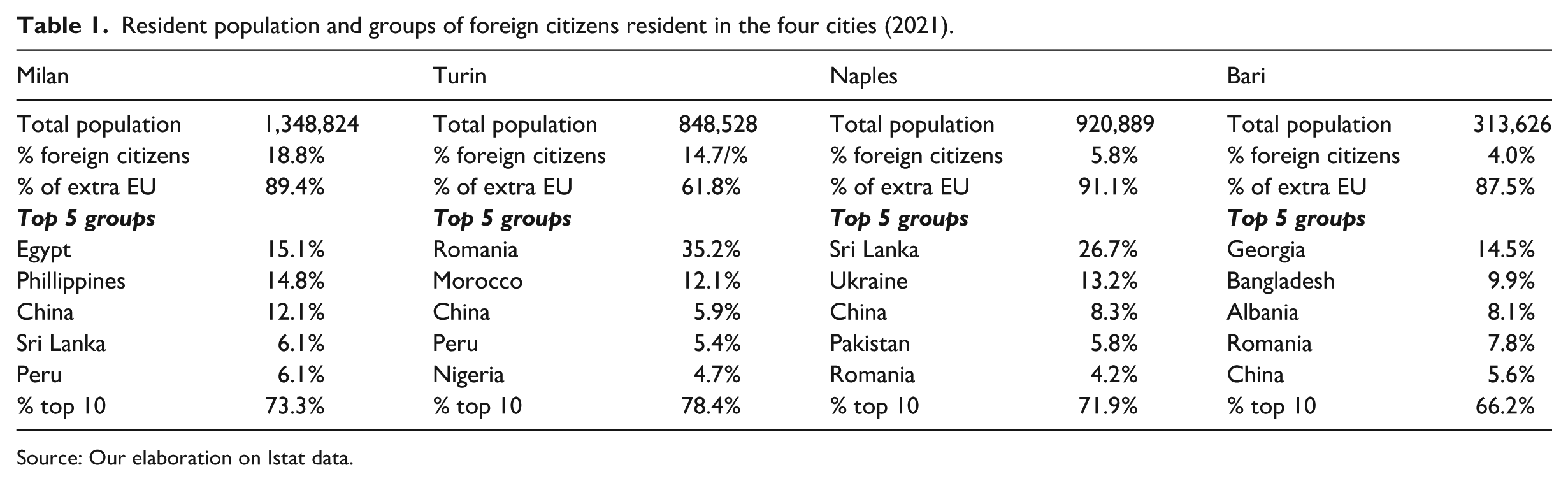
Source: Our elaboration on Istat data.
To perform an accurate comparative analysis of these cities at the sub-urban level, new spatial units recently proposed by Pratschke and Benassi (2024) have been used. These new spatial units (i.e. output areas) are obtained using Martin’s operationalization of Li-Openshaw’s algorithm (Martin, 1997, 2000, 2002) by aggregating the enumeration areas, following several aggregation principles (the population’s minimum and maximum thresholds, geometrical shape, and spatial contiguity 4 ).
Data sources and statistical indicators
Data were drawn from the last available Italian Population Census (2021), information that is publicly provided by the Italian National Institute of Statistics (Istat). We used data regarding age groups, broader subgroups of nationality (Italians, EU citizens and extra-EU citizens), number of household members, level of education and non-employment status of resident population, together with housing conditions. 5 Information regarding these variables was available at the level of enumeration areas, which we aggregated into the new spatial units proposed by Pratschke and Benassi (2024). The indicators used in the empirical analysis are two: one is related to the potential vulnerability, and another is related to the under- or overrepresentation of the foreign groups (EU citizens, extra-EU citizens) compared to Italians. Both indices are computed for each city at a local scale level (i.e. for each of the new spatial units of each city). To measure the potential vulnerability at sub-urban level, we construct a composite index for each city that covers three different dimensions: sociodemographic, socio-economic and housing. The first dimension includes the share of individuals over 70 among the total population and the percentage of households with more than four members among total households. The socio-economic dimension considers measures of low human capital by gender (shares of male/female population with at most the first level of secondary education among total males/females) and non-employment status by gender (not-employed males/females among total male/female population 15–64). The third and last dimension is about housing conditions and is approached through the share of residential buildings in a bad or a very bad state of preservation among total residential buildings. We apply principal component analysis (PCA) to reduce the number of indicators considered into a smaller number of principal components (PCs) that accounted for most of the total variance observed in each city under examination. 6 The composite indexes were built up for each new spatial unit in each of the cities, with those PCs that were retained being weighted by their respective eigenvalues. 7 Finally, indicators were subjected to a Min–Max scaling to obtain the composite Index of Potential Vulnerability (IPV) that ranges from 0 (null potential vulnerability) to 1 (maximum potential vulnerability).
To analyse the sub-urban geography of non-national population subgroups (EU and extra-EU nationals) compared to Italians and to assess the condition of spatial polarization, we estimate the local quotients (LQs; Isard, 1960) for each sub-urban spatial unit of each city. LQs are obtained as a ratio of ratios where, in the first ratio, the total population of the non-national subgroup is divided by the total Italian population residing in the city; and, in the second, the ratio is the same, but the population considered is that residing in each new spatial unit. The LQ then measures the over- or underrepresentation of a subgroup of non-nationals compared to nationals: if the value of the LQ is less than 1 (LQ < 1), the subgroup of non-nationals is underrepresented compared to Italians; if LQ figures are greater than 1 (LQ > 1), non-nationals are, instead, overrepresented. Within this last category, we consider several degrees of overrepresentation: an LQ ranging from 1 to 1.5 is classified as medium, from 1.5 to 2 as high and over 2 as very high.
Local spatial analysis
The final step of the empirical strategy of analysis is dedicated to the estimation of the local versions of the bivariate Moran’s I between the IPV and LQ for each of the four cities considered. This index extends the univariate local Moran’s I (Moran, 1948), and is able to detect the spatial relationship between the values (standardized) of one variable at a given location and the average of the neighbouring values for another variable, that is, its spatial lag (Anselin et al., 2002). In this way, we can examine, on one hand, whether and how the relationship between the IPV and the LQ of non-nationals (EU or extra-EU, respectively) compared to Italians is spatially correlated; and, on the other, we can compare the obtained results across northern and southern cities, searching for patterns of similarities/dissimilarities. Statistical inference was derived using random permutation testing,
8
with a significance level of
According to the significant bivariate local Moran’s I, we obtained five different clusters of spatial relationships at the sub-urban level. The first group includes all those spatial units in which indicators considered are not spatially correlated. The second and the third groups – labelled High–High and Low–Low, correspondingly – are those in which we can find a positive spatial correlation. The last two, the fourth (Low–High) and fifth groups (High–Low), comprise spatial units showing negative spatial correlations.
Results
In this section, we present the results of the local analysis of bivariate spatial correlation between the IPV and LQs. 10 Due to space limitations, the maps and tables related to these two indicators (IPV and LQs) are available in Appendix 1 of the article.
Potential vulnerability and spatial concentration of non-national groups
We focus our attention on the local spatial relationship between the IPV and LQs, analysing this relationship not only within each city and across cities but also by considering the share of population subgroups residing in the resulting correlation clusters. The results from the bivariate local Moran’s I are displayed in Figure 1 for Milan and Turin, the cities of the northern block, and in Figure 2 for Naples and Bari, the cities of the southern block. The local Moran’s I between the IPV and the LQs for EU citizens are shown in the left panel of the figure, while for extra-EU citizens, the results are in the right panel. For the sake of interpretation, we split the comments according to the spatial correlation observed, first focusing attention on the left panel and contrasting findings across cities. The four cities under examination share one pattern: they have a considerable number of spatial units in which there is not a statistically significant clustered distribution of the relationship. But there are some aspects that need to be highlighted, with the highest share in Milan (where 81.3% of units show no statistically significant values for the bivariate local Moran’s I), followed by Naples, Bari and Turin (73.5%, 68.4% and 61.1%, respectively). If, instead, we concentrate attention on the local clusters, a North–South divide seems to emerge, with a more polarized north and a less polarized south. In fact, the share of High–High and Low–Low clusters is the most representative in the cities of the north, and is particularly high in Turin (75.9%, against 45.9% in Milan). That is to say, the most common situations in these cities are, first, that spatial units with a high degree of vulnerability are spatially close to those in which EU citizens are overrepresented compared to Italians, and second, less vulnerable areas are close to units where citizens from EU countries are underrepresented. On the contrary, in the cities of the south, more than 60% of significant clusters lie in the High–Low and Low–High categories. That is to say, these spaces are mixed in terms of vulnerability and concentration of foreign citizens compared to Italians, in which dissimilar values tend to be spatially attracted. In Milan, neither Low–Low nor High–High clusters exhibit spatial concentration. Instead, they display a dispersed yet clustered distribution in the city’s periphery, surrounding the city centre. In other cities, these clusters tend to concentrate in specific areas. In southern cities, in particular, they are often located in the city centres, typically in the old towns.
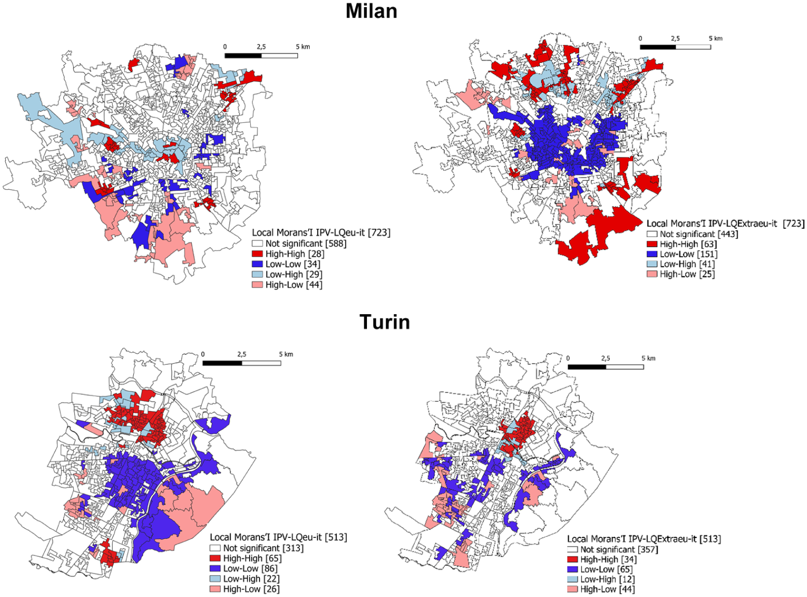
Bivariate local Moran’s I between the IPV and LQs for EU citizens (left) and extra-EU citizens (right) compared to Italians. Milan and Turin (2021).
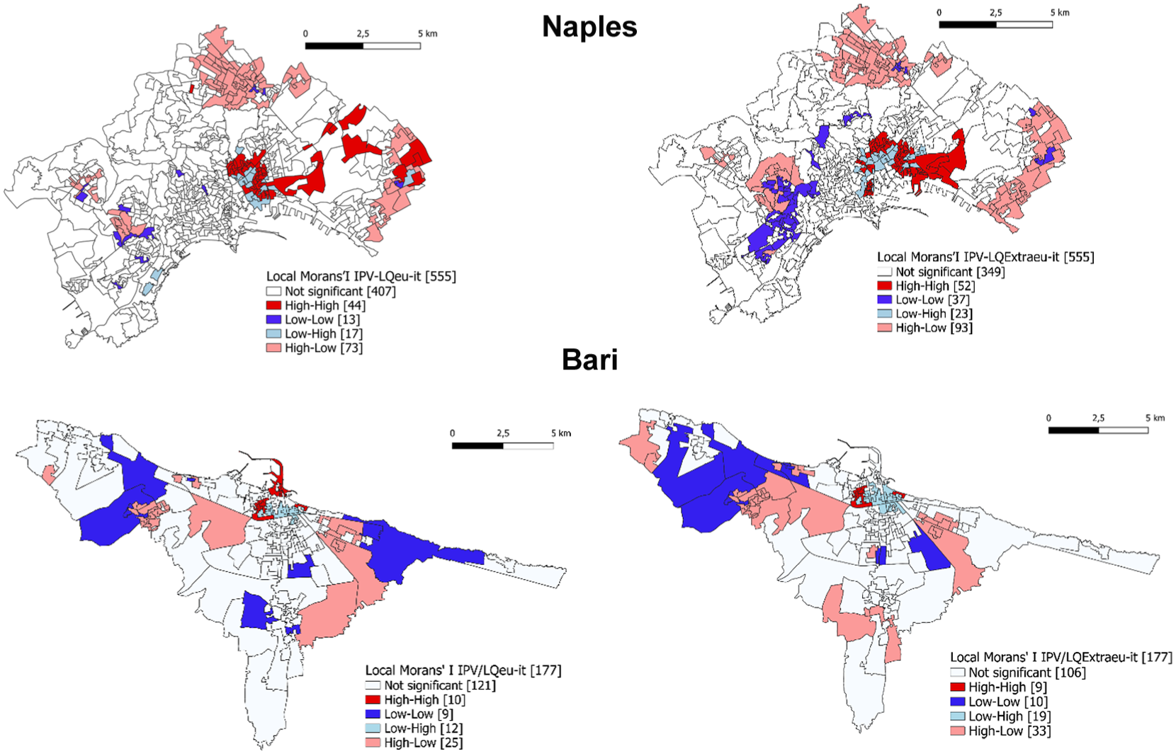
Bivariate local Moran’s I between the IPV and LQs for EU citizens (left) and extra-EU citizens (right) compared to Italians. Naples and Bari (2021).
Turning attention now to the right panel, degrees of variation disappear when analysing the share of units in which no statistically significant spatial correlation emerges. In fact, the range of oscillation of the shares is much shorter, fluctuating from the highest in Turin (69.7%) to the lowest in Bari (59.9%). Again, the North–South divide previously observed seems to be confirmed for significant clusters. When considering the spatial correlation between potential vulnerability and the concentration of extra-EU citizens (compared to Italians), Milan and Turin show clear signs of polarization, given the highest shares of units classified in the High–High and Low–Low clusters (76.4% and 63.9%, correspondingly). In contrast, in the cities of the southern block, most units are grouped in the High–Low and Low–High clusters, where the high values of vulnerability correspond (spatially) to lower values of concentration of extra-EU citizens, or vice versa. With regard to the spatial distributions of these clusters, most cities follow the patterns previously observed, except for Milan, in which the units of the Low–Low cluster are concentrated in the city centre. There, not only spatial units with low values of vulnerability are close to those where extra-EU citizens are underrepresented compared to Italians, but also this is the most common situation (more than half of the units follow this pattern).
Who lives where?
Table 2 shows the proportion of population by subgroups residing in spatial units classified in positive or negative clusters of spatial correlation. Focusing attention on Milan, independent of the subgroup considered, more than 80% of the population resides in areas where the IPV and the LQs are not spatially correlated. In the rest of the cities under analysis, the shares are lower, oscillating between 60% and 70%. An interesting result is that the shares of extra-EU citizens residing in areas appertaining to the High–High clusters are the highest, even higher than those observed among EU citizens. On the contrary, the percentage of extra-EU citizens living in Low–Low areas is the lowest registered.
Percentage of population by subgroups residing in areas classified according to the corresponding bivariate cluster. Correlation between IPV and LQs of EU citizens compared to Italians. Milan, Turin, Naples and Bari (2021).
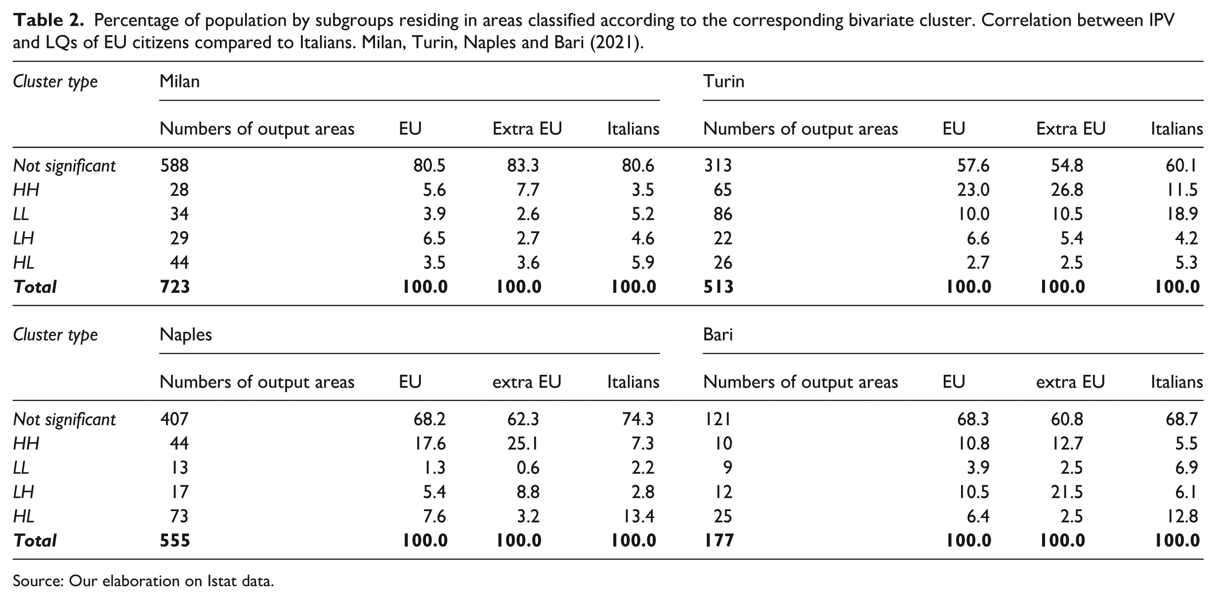
Source: Our elaboration on Istat data.
When considering the spatial correlation between the IPV and the LQ of extra-EU citizens (Table 3), the population is less concentrated in no statistically significant clusters, and this is a pattern shared by the four cities. Again, we can identify a nationals–non-nationals divide in positive correlation clusters. The proportion of foreign citizens residing in the areas of the High–High cluster is systematically higher than that of Italians. Moreover, significant differences emerge when analysing EU and extra-EU citizens, the shares of the latter being always higher than those of the former. Instead, in the areas encompassed in the Low–Low cluster, the percentage of extra-EU citizens is the lowest, followed by that of EU citizens. In this case, we find a clear North–South gradient, given that the shares of extra-EU and EU citizens in this cluster are lower in the cities of the southern block (Naples and Bari) than in those of the north (Milan and Turin).
Percentage of population by subgroups residing in areas classified according to the corresponding bivariate cluster. Correlation between IPV and LQs of extra-EU citizens compared to Italians. Milan, Turin, Naples and Bari (2021).
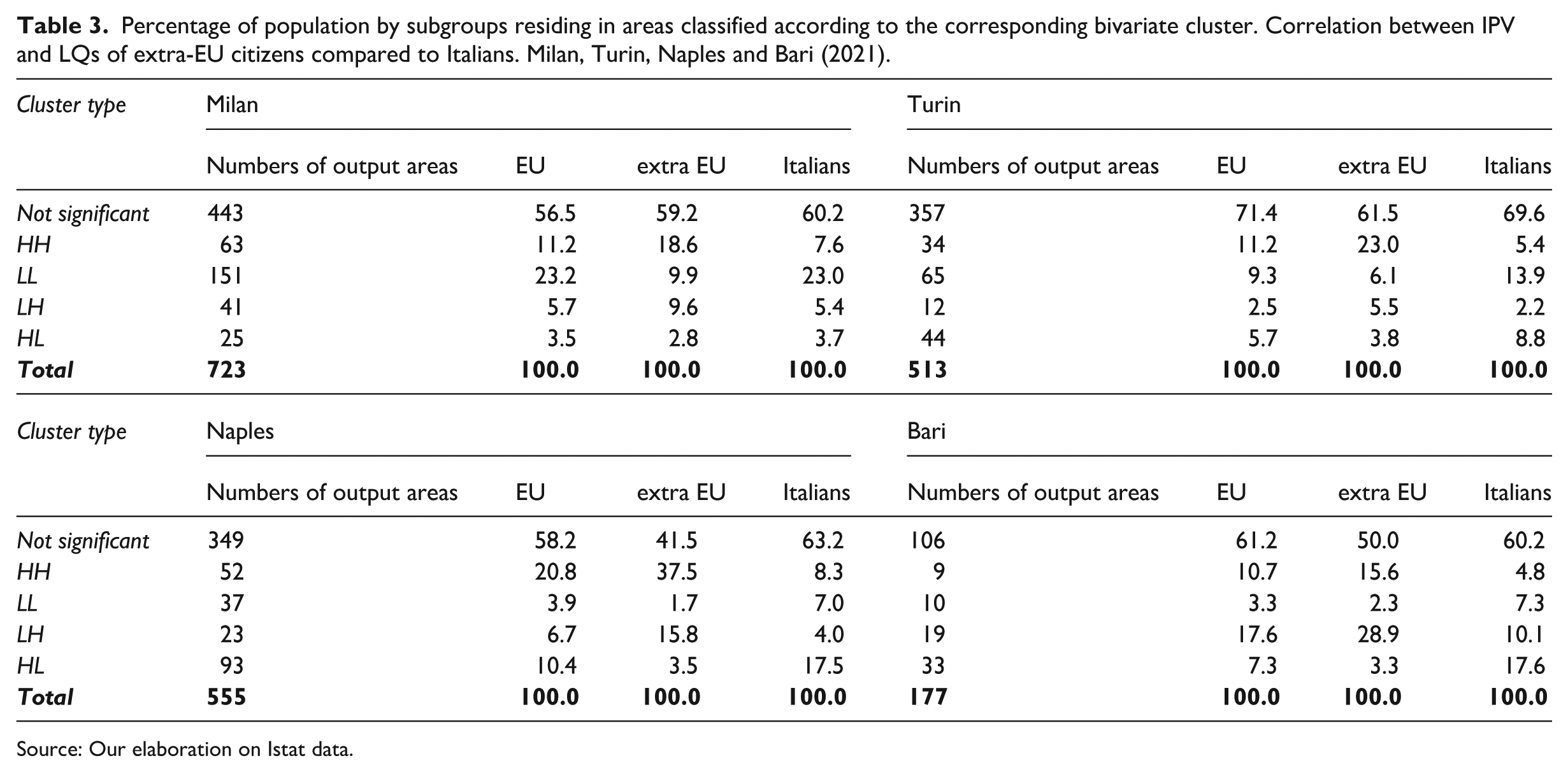
Source: Our elaboration on Istat data.
It is interesting to note that, in Milan, the share of EU citizens living in the spatial units of the Low–Low cluster is nearly the same as that of Italians. In the rest of the cities, there are noticeable differences between EU citizens and Italians.
One of the most interesting findings concerns the high share of Italians who live in areas where high levels of vulnerability are spatially associated with low levels of overrepresentation of both EU and extra-EU citizens (Tables 2 and 3), and this pattern is only observed in the cities of the southern block (Naples and Bari).
Discussion
The contemporary city – conceived and organized as the national driving force of the globalized economy (Alderson and Beckfield, 2004; Sassen, 2006) – has become the main mechanism through which the social and economic living standards of its inhabitants are shaped (Sarkar et al., 2024). Today, these dynamics are unevenly distributed across urban populations, often leading to spatial fragmentation and the segregation of social groups (Morgan and Mareschal, 1999; Van Kempen, 2007). This results in significant socio-economic disparities, both between and within cities (Glaeser et al., 2009), and – particularly in southern Europe – raises critical issues related to governance structures, institutional fragmentation and territorial regimes (Le Galès, 2024; Le Galès and Robinson, 2024; Tulumello and Allegretti, 2021).
Since the early 1990s, these inequalities have been investigated from the perspective of spatial separation that is present in the polarized cities: socio-economic disparities among different neighbourhoods are reflected spatially (Sassen, 1991; Van Kempen and Ozuekren, 1998). According to Sassen’s (1991) theory of ‘global cities’, inequalities in urban spaces are mainly evident between wealthy neighbourhoods, where highly qualified and high-income populations reside, and popular neighbourhoods, characterized by different levels of social hardship or deprivation, including low-income and vulnerable or unskilled populations. Traditional patterns that explain this division have been further summarized in the concept of ‘dual city’ (Castells and Mollenkopf, 1991; Marcuse, 1989) or ‘divided city’ (Fainstein et al., 1992), which implies the division of the urban area into two extreme/opposite poles including rich and poor social classes: these poles grow increasingly apart spatially and socially while the intermediate classes progressively disperse or disappear. Nevertheless, the paradigm of Sassen’s theory, conceived in the North American context, as well as the dual city model, have been questioned overtime. Since the mid-1900s, European scholars have shown that social polarization does not apply uniformly in European cities. Although socio-spatial inequalities seem to increase in European cities (Musterd et al., 2017; Nijman and Wei, 2020; OECD, 2018; United Nations, 2020), the dialectical processes through which they impact urban space and, more specifically, residential segregation vary widely within them (Musterd, 2005). Traditionally, northern and central European cities tend to display a more marked socio-spatial division compared with southern European cities, where this division is less pronounced but more widespread (Arbaci, 2007; Leal, 2004; Maloutas and Fujita, 2012). Nevertheless, this evidence often appears to be reversed when residential segregation is observed with respect to the foreign population living in the cities (Arapoglou, 2012; Benassi and Iglesias-Pascual, 2023; Benassi et al., 2020a). In general, the North–South dichotomy does not necessarily reflect the presence of mechanisms of social differentiation; rather, it identifies the diverse forms with which inequalities manifest themselves in urban contexts, depending on the population subgroups to which it refers (Arapoglou and Sayas, 2009) and on the multitude of determinants and urban histories that can shape them (Arbaci, 2019). Our findings provide new evidence regarding the case of Italy, one of the most significant countries in southern Europe and undoubtedly a major global ‘hot spot’ for immigration in Europe. At the same time, Italy remains deeply marked by historical and entrenched territorial divides. In particular, the empirical analysis conducted at the local level for four major metropolitan cities reveals that the process of polarization occurs on a very local scale. In these four cities, the majority of spatial units do not exhibit clustering in the distribution of IPV and LQs, highlighting the importance of a local-scale approach in social sciences (Fotheringham and Sachdeva, 2022). The North–South divide appears to be confirmed, albeit with new nuances that shed light on the complexity of contemporary urban society in Italy. The northern cities (Milan and Turin) are found to be more polarized compared to the southern cities (Naples and Bari). In the northern context, the majority of local clusters belong to the HH and LL typology, demonstrating the existence of positive bivariate autocorrelation between IPV and LQs. Theoretically, this aligns with Tobler’s (1970) first law of geography 11 and simultaneously highlights the presence of polarized patterns within the urban fabric.
Conversely, in the southern context, the majority of local clusters belong to the HL and LH typology, proving the presence of negative bivariate spatial autocorrelation, which indicates inequalities rather than polarization processes. This distinction represents a significant difference between northern and southern urban contexts in Italy. If we consider a macro indicator of wealth, such as per capita income for the four cities (2020), 12 we find that the two northern cities record much higher values than those of the south (23,201.9 euros per capita for Milan and 16,827.7 euros for Turin, compared to 10,403.0 euros for Naples and 13,536.7 euros for Bari, respectively). This suggests that, from a local spatial perspective, higher average wealth is associated with greater polarization. In contrast, lower average wealth seems to correlate with greater inequality.
Regarding the geographical distribution of these clusters, it can be observed that in the north, they are dispersed in a more scattered manner. In contrast, the south reveals a clearer centre-periphery pattern, albeit inverted: HH clusters are concentrated in the city centre rather than in the periphery (or on the city’s border). If we look at who lives where, that is to say at the geo-demographic profiles of the different cities, some other interesting distinctions can clearly be observed. A nationals–non-nationals divide is confirmed with the second group (i.e. foreign citizens) that usually tends to be more concentrated in specific parts of the city when the potential vulnerability is high. But inequality also arises inside the non-national groups, with the extra-EU citizens being the most exposed to conditions of high vulnerability. So, a sort of double gap emerges underlying the stratification mechanism behind spatial inequalities in the city. One last important finding concerns the different conditions of nationals in the cities of the north and south. It is only in the southern urban areas that we find high shares of Italians living in local contexts where high levels of vulnerability are spatially associated with low levels of overrepresentation of foreign citizens (both EU and extra EU). This pattern simply does not occur in the north. Therefore, it is reasonable to assume that in areas with lower levels of wealth (such as Naples and Bari compared to Milan and Turin), there is a segment of the native population that remains isolated in contexts of high vulnerability. This can be seen as a form of segregation of the (native) poor, which helps in understanding the complexity of the urban fabric in contemporary Italy, especially when compared to the more simplistic concept of social mixing, commonly used to define southern European urban contexts. The reasons for this outcome can be multiple, and we do not have enough information to investigate them. The idea is that, in many cases, these may be areas of high marginality and native poverty, but also of high spatial saturation and low accessibility, making them closed to new immigrants. Furthermore, the condition of marginality does not generate a demand for family services from foreign communities, which, for this reason as well, do not settle in these areas.
The spatial dynamics of residential segregation in Italy exhibits significant territorial variation, shaped by city-specific housing systems, institutional filters, and socio-economic trajectories (Daconto and Montesano, 2024). Milan and Turin display more structured and polarized segregation patterns, characterized by the concentration of extra EU citizens in High–High clusters. In contrast, southern cities such as Naples and Bari show more diffuse and layered forms of marginality.
In Milan, the coexistence of Italians and EU citizens within Low–Low clusters suggests partial integration through formal housing and labour channels. However, this may reflect selective inclusion into relatively ‘non-problematic’ peripheral areas rather than full incorporation. Conversely, extra EU citizens are overrepresented in High–High clusters – areas marked by cumulative disadvantage, informal housing, and labour precarity. This duality aligns with previous studies highlighting Milan’s paradoxical combination of low spatial segregation and high institutional selectivity (Consolazio et al., 2023; Rimoldi and Terzera, 2017; Vitale et al., 2008).
Turin, undergoing a post-industrial transformation, similarly exhibits spatial polarization. Migrant settlement patterns are closely linked to economic vulnerability, the decline of manufacturing and restructuring of the housing market (Cenere et al., 2023; Marra et al., 2020). These dynamics underscore how socio-spatial inequality in northern cities is reinforced by housing market segmentation, selective welfare regimes and spatial filters associated with access to public housing.
In contrast, Naples and Bari are shaped by entrenched informality, weak enforcement, and limited institutional capacity. Marginality in these cities is less spatially structured and more deeply embedded in fragmented, historically stratified urban fabrics. In Naples, the predominance of Italian citizens within High–High clusters reflects persistent exclusionary patterns, as documented in prior studies (Benassi and De Falco, 2025; Morlicchio, 2018; Pfirsch, 2023). Recent research in Bari (Carella et al.,2024, 2025) highlights the overlap between socio-economic stress and foreign presence, contributing to the growing literature on southern urban marginality (Tulumello and Allegretti, 2021; Zambon et al., 2017) and reinforcing our findings.
A comparative reading suggests that segregation patterns result from the intersection of several mechanisms, ranging from the structure and selectivity of housing systems and real estate dynamics to demographic transformation, immigration flows and local governance capacity. Stronger institutional frameworks and more rigid housing markets in northern cities foster more spatially defined segregation. Conversely, weaker state presence and informal settlements in the south generate more fluid, though no less severe, forms of marginality.
These mechanisms should not be viewed as deterministic but rather as interpretive hypotheses derived from spatial evidence in our empirical analyses. Integrating these perspectives can advance our understanding of the spatial structures underlying segregation dynamics in contemporary Italian cities.
Conclusion
The study, conducted on four of the major Italian cities using a local scale of analysis and adopting ad hoc analysis areas, has enabled a better understanding of the complexity of the spatial patterns that characterize contemporary Italian cities. Some issues have been confirmed, such as the North–South divide, while others have emerged, such as the disadvantage of natives in southern contexts. In general, new nuances have been appreciated, enriching the knowledge of socio-spatial inequalities in Mediterranean Europe. In wealthier Italian northern contexts, polarization processes are more intense compared to the less wealthy southern contexts, which, however, are characterized by greater inequality. While it is true that in all contexts foreign citizens are more disadvantaged, it is equally true that within this group, extra-EU citizens are the most vulnerable, confirming the existence of vicious cycles of marginalization. This is assuming that extra-EU citizens are generally less resourceful and culturally further removed from the EU citizens, in relation to the culture and language of the host contexts. Finally, in southern contexts, there is a condition of spatial isolation of Italians in high vulnerability areas, where the presence of foreign citizens is low. This last aspect, not found in northern urban contexts, seems to challenge the existence of more intense social mixing in the south. It is important to keep in mind that one key factor influencing the residential geographies of different foreign communities is employment, particularly the type of job performed and the economic sector of employment, which we know varies significantly from one community to another. Foreigners living in cities in the north generally have a wider range of job opportunities compared to those in the south, where domestic work and assistance to local families represent a more common – and likely predominant – occupation, but only in areas where affluent families reside. This could partly explain the total, or near-total, absence of foreigners in the most degraded and marginalized areas of southern cities, where native residents are more prevalent. The stark contrast in segregation dynamics between northern and southern Italian cities likely reflects a combination of intersecting factors. In the north, stronger real estate pressures, selective public housing policies, and institutional filtering mechanisms foster more structured forms of socio-spatial polarization. In the south, by contrast, widespread informality, weaker governance, and stagnant market conditions contribute to more diffuse, layered patterns of vulnerability. These divergent trajectories align with recent findings by Buonomo et al. (2024) on demographic and spatial restructuring in Italy, and point to the need for a localized understanding of segregation – one grounded in the specific housing systems, institutional arrangements, and urban morphologies that shape Italian cities. Crucially, as migrants become increasingly concentrated in areas marked by multiple and overlapping disadvantages (Benassi et al., 2025), segregation emerges not merely as a demographic phenomenon, but as an outcome of governance and policy failure. Naturally, the study has limitations, such as the limited number of case studies analysed and the variables used for constructing the IPV, which were dictated by the availability of census data and do not allow for granular information on wealth and other important dimensions for measuring vulnerability. Furthermore, while the distinction between EU and extra EU foreigners is both conceptually sound and commonly adopted in this type of research – also to ensure a minimum level of numerical robustness in small-scale population analyses – it inevitably entails a degree of information loss, as is the case with any categorical simplification. From this perspective, when interpreting the results, one cannot rule out the presence of compositional effects, especially in instances where certain national groups (e.g. Romanians) may exert a disproportionate influence on the broader category of EU foreigners in some areas but not in others (as observed, for example, in the case of the city of Turin). Last but not least, this study represents a necessary first step in understanding the spatial articulation of socio-economic vulnerability and foreign presence across Italian cities. However, it is important to acknowledge the limitations of relying solely on (local) spatial clustering techniques. Future research should move beyond pattern detection to assess the implications of such patterns for urban life. In particular, integrating network-based accessibility measures, indicators of public service provision, and time–space availability models would allow for a deeper analysis of how spatial concentration translates into differentiated access to resources. As recent work (e.g. Benassi and De Falco, 2025) has shown, segregation is not only a matter of residential concentration but also of unequal access to infrastructures of opportunity. High–High clusters may thus mark not only areas of deprivation but also zones of limited institutional presence, poor connectivity and reduced service reach. A more comprehensive, resource-based approach to urban space is therefore essential to understand the lived consequences of socio-spatial inequality. We hope to address these limitations in future work.
Footnotes
Appendix 1
Results of the principal component analysis: southern cities (Naples and Bari).
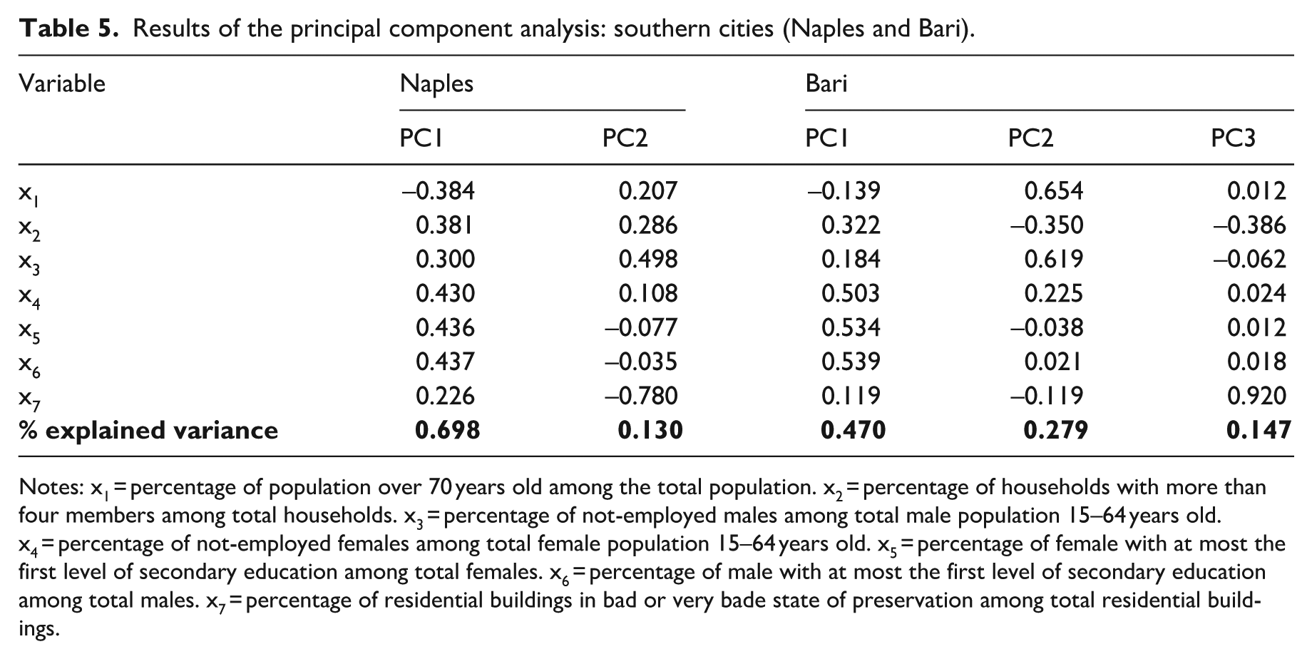
| Variable | Naples | Bari | |||
|---|---|---|---|---|---|
| PC1 | PC2 | PC1 | PC2 | PC3 | |
| x1 | –0.384 | 0.207 | –0.139 | 0.654 | 0.012 |
| x2 | 0.381 | 0.286 | 0.322 | –0.350 | –0.386 |
| x3 | 0.300 | 0.498 | 0.184 | 0.619 | –0.062 |
| x4 | 0.430 | 0.108 | 0.503 | 0.225 | 0.024 |
| x5 | 0.436 | –0.077 | 0.534 | –0.038 | 0.012 |
| x6 | 0.437 | –0.035 | 0.539 | 0.021 | 0.018 |
| x7 | 0.226 | –0.780 | 0.119 | –0.119 | 0.920 |
|
|
|
|
|
|
|
Notes: x1 = percentage of population over 70 years old among the total population. x2 = percentage of households with more than four members among total households. x3 = percentage of not-employed males among total male population 15–64 years old. x4 = percentage of not-employed females among total female population 15–64 years old. x5 = percentage of female with at most the first level of secondary education among total females. x6 = percentage of male with at most the first level of secondary education among total males. x7 = percentage of residential buildings in bad or very bade state of preservation among total residential buildings.
Acknowledgements
All authors made substantial contributions to this paper. Federico Benassi led the theoretical and methodological conceptualization, the preparation of the ad hoc geographical layers, and the writing (first draft and revisions). Maria Carella was primarily responsible for the literature review and drafting the theoretical sections. Thaís García-Pereiro managed the database, data preparation and formal data analysis, including mapping and the investigation. Anna Paterno and Salvatore Strozza took the lead in critically reviewing the manuscript and enhancing its overall coherence. A previous version of this article was presented by Thaís García-Pereiro at the international workshop ‘Social Inequalities and Residential Segregation in South European Urban Areas: Current Trends, Challenges, and Public Policy Options’, organized by Federico Benassi, Ricardo Iglesias-Pasqual, and María Ángeles Huete García, and held in Seville in October 2024. The paper was presented in the session ‘Space of Disruption and Social Invisibility: The Spatial Dimension of the Dual City’ (Chair: Federico Benassi). The workshop was organized with financial support from European Urban and Regional Studies (call for thematic workshops and related thematic issues). We are grateful to all workshop participants for their valuable suggestions and the journal editors. Federico Benassi also wishes to acknowledge Prof. Jonathan Pratschke (University of Naples Federico II) for his consent to use the ad hoc spatial domains for this study.
Declaration of conflicting interests
The authors declared no potential conflicts of interest with respect to the research, authorship and/or publication of this article.
Funding
The authors disclosed receipt of the following financial support for the research, authorship and/or publication of this article: The paper was conceived and realized as part of the PRIN2022-PNRR research project ‘Foreign population and territory: integration processes, demographic imbalances, challenges and opportunities for the social and economic sustainability of the different local contexts (For.Pop.Ter)’ (P2022 WNLM7; CUP: E53D23019190001), funded by European Union – Next Generation EU, component M4C2, Investment 1.1. The views and opinions expressed are only those of the authors and do not necessarily reflect those of the European Union or the European Commission. Neither the European Union nor the European Commission can be held responsible for them.
Ethical approval and informed consent statements
Not applicable.
Data availability statement
All the data used in the empirical analysis are freely downloadable from the Italian National Institute of Statistics (Istat) website.