
Abstract
The critique of urban sprawl and the increased focus on low-carbon transitions have led to changes in urban and regional policies and planning in many city regions. This article examines sociocultural and lived dimensions of suburban sustainable mobility transitions by exploring different spatial imaginaries of suburban towns, mobility systems, and sustainable transitions from the perspectives of new residents, real estate marketing, and regional transport planning in the Greater Oslo Region. Empirically, the article investigates how households who have recently relocated to transit-oriented suburban nodes designed to promote low carbon mobility perceive the role of mobility prospects in their decision to relocate. This exploration is set against other social and material features at their new residential location. The article includes an analysis of the spatial imaginaries of regional transport plans and real estate marketing, as these imaginaries potentially play an important role in the spatial transformation and comprehension of these places and spaces and further households’ decisions to move there. These spatial imaginaries are contrasted with in-movers’ imagination, revealing potential disconnections between planning ideals, marketing strategies, and lived experiences. By shedding light on the interplay between spatial planning, marketing strategies, and lived experiences, this research contributes to broader discussions in mobility, housing, urban studies, and planning, promoting a nuanced understanding of the socio-cultural factors of sustainable suburban transformations.
Keywords
Introduction
The development of suburbs has always been closely related to advancements in transport technologies, which illustrates how urban development and mobility are intrinsically linked. Public transport has played a vital role in suburbanization, as trams, trains, and metro systems have enabled people to live in suburban locations and commute to the city (Hall, 2014; Mace, 2009). However, the mass introduction of cars and road infrastructure is often argued to be the main contributor to suburban growth and urban sprawl (Sheller and Urry, 2000). Urban sprawl, low-density development around urban areas, has been related to high car dependency and identified as one of the main contributors to the growth of greenhouse gas (GHG) emissions from transport (Newman and Kenworthy, 1989; Næss, 2006). Accordingly, land-use changes and infrastructure provision have been identified as one of the primary ways in which transport is conceived to be decarbonized (Schwanen et al., 2011). Several associated challenges with urban sprawl include the degradation and disruption of nature and biodiversity (European Environment Agency (EEA), 2022; Miller, 2012). The critique of urban sprawl and the increased focus on low-carbon transitions have led to changes in urban and regional policies and planning in many city regions. As Dunham-Jones and Williamson (2011) assert, the systematic development of suburban sprawl has been the major architectural project for the last 50 years. However, they propose that the redevelopment of sprawl into more urban, more connected, more sustainable places is the big project for this century (6). This renewed focus is evident in the development of generic polycentric regional planning models seeking to connect the city and its fringes by enhancing public transport networks, developing transit-oriented nodes, and mixed-use development in the suburbs by compact city design (Bergsli and Harvold, 2018). The logic behind these spatial planning strategies is that access to public transport through transit-oriented development (Renne et al., 2009) and proximity to services by compact city design will promote transit, walking, and biking. These strategies presume that living in transit-oriented compact centers will promote less car-dependent lifestyles. The positive correlation between TOD and Compact city design and public transit, biking, and walking, is also supported by empirical studies on how urban structure, the built environment, and infrastructure provision affect travel behavior (Saelens and Handy, 2008; Stevens, 2017). Empirical studies in the Norwegian context have also provided evidence that centrally located and more densely built-up areas and areas with accessible public transit at residence and workplace locations lead to less car use (Engebretsen et al., 2018).
This exemplifies a scalar understanding of transport that acknowledges regional and local mobility and illustrates how suburbs can be included in regional sustainable mobility transitions (Næss, 2006). A critique of these spatial strategies is that they are overly focused on material structures and how they determine how people travel (Wikstrøm & Røe, 2023). As mobilities studies have rightly pointed out, mobility is more than the movement from A to B. Mobility is a meaningful social practice that is unevenly distributed and accessible, and various social, cultural, political, material, and embodied dimensions affect how and why we move. Furthermore, places are also socially produced, and people have the agency to rework and resist the built environment (Lefebvre, 1991), which may lead to new practices not intended by the planners (Lees, 2001). When implemented, urban planning will have material and architectural outcomes regarding changes in urban form and design. However, it can also lead to changes in demography, social practices, place identity, and sense of place (Røe, 2014). Such sociocultural implications and their role in sustainable transitions are often overlooked in discussions of sustainable compact city development, which mostly focuses on urban form (Haarstad et al., 2022). The same goes for research on suburbs, primarily focusing on physical, economic, and governmental traits and changes. At the same time, the sociocultural and lived dimensions of suburbia and low-carbon suburban transitions remain largely underexplored (Keil, 2018). Suburban lifestyles have been critiqued for representing a homogeneous and even boring and conservative way of living (Jacobs, 1962), both in academia and in popular culture, and suburbs are often represented as a different sociospatial construct than the city both in physical form and in culture thus presenting different ways of life. However, this stereotypical imaginary of the suburb has been nuanced over the years, and there is a growing recognition of the social and spatial diversity of suburbs, as there is not one suburbia but a diversity of suburbs and suburban lifestyles (Keil, 2018).
Creating a sustainable city region depends on transforming suburbia’s spaces, infrastructures, practices, and cultures (Røe, 2014). Successful transformation of the multifaceted suburban landscape calls for acknowledgment of the different suburban geographies and im|material contexts. For example, knowing who and why people live in the suburbs and how and why they travel can be valuable information when developing sustainable plans and policy measures. Nevertheless, spatial planning measures are often generic and idealized and do not consider these contextual variations.
This article addresses the need for more knowledge on the sociocultural and lived dimensions of suburban sustainable mobility transitions by exploring different spatial imaginaries of suburban towns, mobility systems, and sustainable transitions from the perspectives of new residents, real estate marketing, and regional transport planning in the Greater Oslo Region. Empirically, the article investigates how households who have recently relocated to transit-oriented suburban nodes designed to promote low-carbon mobility perceive the role of mobility prospects in their decision to relocate. This exploration is set against other social and material features at their new residential location. The article includes an analysis of the spatial imaginaries of regional transport plans and real estate marketing, as these imaginaries potentially play an important role in the spatial transformation and comprehension of these places and spaces and further households’ decisions to move there. These spatial imaginaries are contrasted with in-movers’ imagination, revealing potential disconnections between planning ideals, marketing strategies, and lived experiences. By shedding light on the interplay between spatial planning, marketing strategies, and lived experiences, this research contributes to broader discussions in mobility, housing, urban studies, and planning, promoting a nuanced understanding of the socio-cultural factors of sustainable suburban transformations.
The article discusses empirical findings from a qualitative study of 17 household interviews and an analysis of planning documents and real estate marketing. The households interviewed had recently moved to, the suburban towns Lillestrøm and Ski, in the Greater Oslo Region, undergoing planned transitions (Bergsli and Harvold, 2018). The article starts by discussing research on housing and mobility. The following section introduces the concepts of imaginaries and imagination and suggests how they can be used in housing and mobility studies. Furthermore, the case sites and methods are introduced. The following sections further discuss the empirical material and the theories and concepts presented in the article. The article ends with a conclusion that highlights the papers, contributions, limitations, and suggestions for future research.
Between residential and daily mobility
Housing studies have a long tradition of researching why people move, establishing that households have different needs and preferences regarding where they want to dwell. In most cases, choices are restricted by factors such as income, housing markets, and job markets (King and Brown, 2005). The decision to relocate is often linked to life events such as having children, moving in with a partner, divorcing, getting a new job, or retiring (Feijten, 2005). Seeking to improve living conditions by upgrading the housing or neighborhood situation also plays an essential role in the relocation decision-making process. Several studies have explored how social and cultural capital affect residential choice, needs, and preferences and how social characteristics make a place attractive (Butler and Robson, 2001; Mazanti, 2007). The decision to move to a new place can depend on a place’s functionalistic and materialistic characteristics, such as transport infrastructure. The decision can also be motivated by symbolic attachments and belonging to place (Savage et al., 2005). This calls for conceptualizing places in housing studies in a way that captures their material and sociocultural dimensions (Røe, 2014).
Housing is often conceptualized as something static and sedentary. Nevertheless, daily mobility practices are intrinsically linked to one’s residential location, as this location can enable and hinder movement because of accessibility to infrastructures and relative location to other activities. Thus, Housing is vital when understanding daily mobility and can be conceptualized as a mooring (Dufty-Jones, 2012). Furthermore, residential relocation can be a strategy to improve accessibility or motility, which is the potential to move (Kaufmann et al., 2004). Several quantitative transport studies study the relationship between residential location and travel behavior. The focus has been on how urban form and infrastructure provision at the residential location structure travel behavior (Ewing and Cervero, 2010; Næss, 2006). Other transport studies have also investigated the reversed causality of residential self-selection, meaning that people choose their residential location because it enables them to travel the way they prefer (Cao et al., 2009; Næss, 2009; van Wee and Cao, 2020). The latter strand of studies has also pointed out how access to transport modes and infrastructures might affect relocation decisions (De Vos and Ettema, 2020). This article explores the importance of mobility prospects in the household’s decision to relocate, alongside other social and material features at the new residential location, thus adding to this existing literature.
The article draws inspiration from the mobilities literature, acknowledging that a range of im|material aspects and rationales beyond housing density and location are involved in structuring daily mobility practices, such as the embodied, sensorial, affective, and shared cultural meanings of mobility (Cresswell, 2010; Hannam et al., 2006; Jensen, 2013). To better grasp the structuring of suburban daily mobility this article use the concepts of spatial imagination and imaginaries.
Spatial imagination and imaginaries
This article draws on the concepts of imagination and imaginaries to explore how people make sense of their residential choices and the place they have moved to. Imagination is understood as performative, representing a dialectic between cognitive processes and lived practices. Imagination can inform actions, both consciously and unconsciously. Recent research has started to explore how mobility is partly shaped by imaginaries and imagination, as pointed out by Salazar (2020): “[The] motivations to travel are usually multiple, but greatly linked to the ability of people and their social networks to imagine other places and lives” (p. 773). I will argue that imagining other places and lives is also important for the motivation to move to a new residential location. When actively considering or seeking a new place to live, part of the process is to imagine different places and how it would be to live there. When viewing a house, one might imagine and reflect on how it might be to live in the house, how to furnish it, how the neighborhood is, and how moving to this location can have potential consequences for future daily routines and mobility. The degree and detail of imagination will always vary. However, it is an integral part of a decision-making process to imagine the possible consequences of a choice as imagination: “forms an essential part of the continuous process of crafting selfhood and concrete strategies for future mobility” (Sjöberg and D’Onofrio, 2020, p. 745). Accordingly, the concept of imagination can contribute to housing studies looking into different motivations for relocating.
While imagination is usually understood as held by individuals, imaginaries are conceptualized as shared and collective. Collective spatial imaginaries, such as those presented in films, literature, and media discourses, can also (re)produce how people relate, imagine, and perceive places and how it is to live and travel there (Davoudi, 2018; Watkins, 2015). Moreover, collective imaginaries can be understood as shared meanings and assumptions through which people experience and understand themselves and the world, which then again can form what is seen as viable, obtainable, and desired options, choices and outcomes (Celermajer et al., 2024) Spatial planning strategies, such as compact city development, encompass spatial imaginaries, which are: “socially held stories, ways of representing and talking about places and spaces” (Watkins, 2015: 509). Such imaginaries of urban futures reduce the complexity of economic, political, and social relations and demarcate what, who, and which places are represented as part of the imaginary. Accordingly, they are built on specific types of knowledges and are entangled with power relations (Davoudi & Brooks, 2021). However, at the same time as being discursive representations offering spatial interpretations, these imaginaries can also be performative and have material consequences, as argued by Davoudi (2018):
Planning tools such as maps, images, diagrams, and scenarios do not simply represent an urban future. They also perform the future in the present, and by doing so, they essentialize a specific imaginary of urban futures which has material consequences for how cities are planned, redeveloped, invested in, and reimagined. (103)
Spatial imaginaries are (re)produced by combining human and non-human actors that are part of current market-oriented planning regimes and can be used to legitimize policies (Davoudi, 2018; Johnson et al., 2019). Some spatial imaginaries become hegemonic spatial planning strategies, such as the imaginary of the polycentric city region, which is often argued to be the ideal spatial strategy to increase economic competitiveness and reach mitigation goals (Davoudi, 2003). This illustrates the mobility of spatial imaginaries as they can travel across borders as part of the transnational mobility of urban policies (McCann and Ward, 2010) or the mobility of ideas (Urry, 2007).
Watkins (2015) argues for distinguishing between three categories of spatial imaginaries: places, idealized spaces, and spatial transformations, which all tell different spatial stories and are used by actors in different ways. Place imaginaries refer to a specific geographical location, such as Oslo, communicating ideas about a wide variety of phenomena supposedly characteristic of that place (Watkins, 2015, p. 12). Place imaginaries can include ideas of both physical traits and a sense of place. Idealized spaces attribute the broader and, in some cases, generic spatial categories such as transit-oriented suburbs. Finally, spatial transformations capture spatial processes, such as gentrification or densification. Shared spatial imaginaries can potentially play an important role in shaping understandings of mobility prospects and places and are thus of particular importance in understanding how mobility prospects guide relocation decisions.
The concepts of spatial imagination and imaginaries can be used as theoretical tools for investigating suburban mobility and place-making. They offer a way to understand how different actors conceptualize, imagine, and interact with spaces. It can be used to investigate how suburban residents perceive and imagine the places they live in and how planners conceive it. Illuminating conflicting spatial imaginaries can aid in addressing barriers to suburban mobility transitions. Investigating spatial imaginaries can uncover how images of space influence mobility practices and residential choices. For example, certain areas might be imagined as safe or dangerous, desirable or undesirable, affecting how and where people travel, what modes of transportation they use, and where they seek to live. This can help unpack how cultural, historical, and social constructs shape people’s movement through suburban spaces, revealing broader patterns of inclusion and exclusion, which are insights that can be deployed in housing and mobility studies. Spatial imaginaries can also inform how communities create shared narratives, contributing to place-making. Spatial imaginaries can also be used to analyze spatial planning strategies. Furthermore, it is possible to utilize spatial imaginaries in mobility planning to promote more inclusive and potentially successful interventions by acknowledging the diverse ways places are imagined.
Case sites
This article discusses an empirical study conducted in the Greater Oslo Region in Norway, a region going through a planned transition to mitigate emissions from transport. Suburban development in Norway and the Greater Oslo Region differs significantly from North American examples, where much of the literature on suburbanization comes from spatial development and political economy. Urban sprawl and mass car ownership have been more prominent in North America’s suburbanization than in Norway. In addition, suburbanization in Norway has been driven less by large private developers and the extensive construction of single-family houses than in North America. On the contrary, public authorities and regulated overall planning have played a key role in developing Norwegian suburbs. Land use policies protecting recreational lands and agricultural areas, transit-oriented planning, and investments in public transportation are examples of long-lasting policies that have played a crucial role in Norwegian suburbanization (Røe, 2017). These policies have contributed to more concentrated and controlled (sub)urban development.
Nevertheless, efforts are put in to hinder uncontrolled sprawl and reduce car use in The Greater Oslo Region. The regional authorities have formulated a regional land-use and transport plan setting the premises for the land-use development (City of Oslo and Akershus City Council, 2015). The plan is from 2015 and is still the prevailing regional policy document guiding the overall land-use development of the region. The overall spatial strategy is to strengthen the polycentric structure of the region by increasing the capacity of the public transport system and enhancing the already established compact city policy by concentrating housing, workplaces, and commercial activities around existing transit nodes. Oslo is the region’s focal point and the largest and dominant city in many ways. Thus, the region is quite monocentric, contrary to polycentric regions such as the Ruhr in Germany. The plan seeks to create a system of multifunctional regional towns served by a rail network with high frequencies and connected to local public transport systems (Figure 1). The rail network mainly consists of radial lines connecting these towns to Oslo.
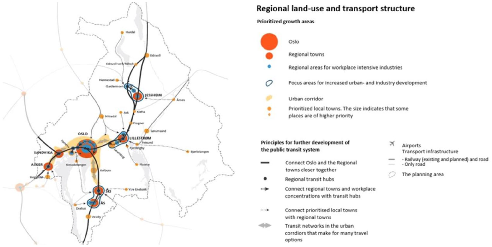
Map from the regional land-use and transport plan for the Greater Oslo Region (City of Oslo and Akershus City Council, 2015: 7).
In the regional towns, the plan’s logic is that reduced distances between services combined with improved public transport will promote active modes and public transport and thereby reduce car dependency. It is argued that this spatial strategy is the best way to achieve both economic growth and GHG emissions from transport (Bergsli and Harvold, 2018). The regional land-use and transport plan does not represent a new vision for spatial planning in the region but an intensified continuation of the current planning policy, with a more dedicated focus on mitigation and environmental benefits (Røe et al., 2022).
It is important to note that suburban development in Norway and the Greater Oslo Region differs significantly from examples outside Scandinavia in terms of spatial development and political economy. Mass car ownership has been less prominent in the suburbanization of Norway compared to, for example, the US and the UK. In addition, suburbanization in Norway has been driven less by large private developers and the extensive construction of single-family houses. On the contrary, public authorities and planning have played a key role in developing Norwegian suburbs. Land-use policies protecting recreational agricultural land and investments in transit are examples of long-lasting policies that have played a crucial role in Norwegian suburbanization (Røe, 2017). These policies have contributed to a more spatially concentrated and controlled (sub)urban development.
In this article, I analyze the empirical data from the two regional towns Lillestrøm and Ski (Figure 1). The rationale for selecting these case sites is threefold. First, they are both identified as regional towns in the regional land-use and transport plan, which means these sites are designated growth areas. According to the regional land-use and transport plan, 80 to 90 percent of the residential and workplace growth should happen in the appointed growth areas. Thus, these towns are going through a planned transformation, which includes, land-use changes, densification, demographical changes, and an increase in their multifunctional character by offering a broader range of centrally located services, workplaces, and apartment buildings. Second, being appointed the status of regional town and having this “position” in the regional hierarchy of places, these centers also benefit from a national, regional, and local policy landscape supportive of climate mitigation strategies. Third, both Lillestrøm and Ski are similar in that they have high-speed train connections to the center of Oslo, making it faster to go to Oslo by train than car. The railway has played an important role in the development and history of both towns. A train station was located in Lillestrøm in 1862 and Ski in 1879. The high-speed train lines have shortened the distance between the towns and Oslo (in time and perception), which makes them more attractive for developers and, according to media discourse for potential in-movers.
Case sites
Lillestrøm is located northeast of Oslo, and in 2019, its population was 21.789 (Statistics Norway, 2023b). Lillestrøm is the administrative center of its municipality (85.757 inhabitants). Car use in the municipality caused emissions of 82.902 ton CO2 equivalent in 2009 and 48.687 in 2021 (Miljødirektoratet, 2023), and the number of electric vehicles nearly doubled from 2020-2023 (Statistics Norway, 2024).
In addition to a high-speed train 10 minutes to Oslo, the airport express train and suburban and national train lines also pass through the town. The airport express train started running in 1998 and has been an important generator of growth and development, in addition to the reduced travel time to Oslo. Lillestrøm has a more urban character than Ski. The urban transformation of the town center is especially evident in the new high-rise apartment blocks located next to the train station. Lillestrøm also has historic residential areas surrounding the center, mainly villas and row houses. Such residential neighborhoods are typical for small Norwegian towns and suburbs. Lillestrøm has been ranked the best cycle town in Norway several times in the last decade. There are several large real estate projects in Lillestrøm, and many of them are centrally located close to the train station. Some projects are finished, with people moved in, while others are under construction. The new real estate projects mainly consist of residential blocks, varying from a few floors up to 19 floors. This building typology is deemed untypical for small suburban towns in the Norwegian context. It is usually associated with larger urban centers or more peripheral suburbs with more low-income households. These new high-rise buildings have been widely debated and met with both resistance and praise from locals. Introducing new building typologies illustrates these towns’ material and imagined transformation from small suburban towns to urban centers.
Ski is a small town located south of Oslo, with a population of 19.546 inhabitants in 2019 (Statistics Norway, 2023a). It is the administrative center of the municipality Nordre Follo (58.000 inhabitants in 2020). Emissions from private car use in the municipality were 31.168,5 tons CO2-equivalent (CO2 equivalent means that the emissions for each gas are weighted according to the gas’s global warming potential) in 2020, reduced from 48568,5 ton in 2015 (Miljødirektoratet, 2023). The reduction of emissions from private car use does not entail a reduction in car use. The modal split has been relatively stable during the same period, with a car share of approximately 60 percent (except during the pandemic when there was an increase in car use and a decrease in public transport, which is now stabilized) (Ruter). The reduction in emissions comes from technological developments and the increase in electric vehicles, which has nearly doubled from 2020-2023 (Statistics Norway, 2024) In Ski, the physical transformation started later than in Lillestrøm, but investments and new development projects have accelerated in the last few years. Ski has a suburban vibe and consists of a small city center surrounded by wooden houses. Real estate developers have invested in the area and are building large-scale housing projects, including centrally located high-rise apartments. The long-awaited high-speed train from Oslo to Ski has been one of the main contributing factors to real estate development interest in the area. The high-speed train opened in December 2022. His Majesty the King of Norway had the honor of officially opening the train line at the ribbon-cutting ceremony. The Prime minister, the former Mayor of Oslo, and the Mayor of Nordre-Follo (Ski) were also present. Their participation illustrates the importance of this train line, both regionally and nationally. At the opening ceremony, there was a train marked with a celebratory text, which translates to “Congratulations on an easier daily life.” The train line was temporarily closed shortly after the opening due to technical issues, which have been met with critique from the public. The rail line is highly present in the marketing strategy of several real estate projects in Ski, and real estate agents were present at the opening and interviewed by the media.
A high-speed train line was opened in December 2022, reducing the travel time from Oslo to Ski to 11 minutes. The architecture and design of the new station are characterized as more modern and forward-looking than the old, and the architects state that they sought to make the station visible in the cityscape (LPO Arkitekter, 2023a), arguably seeking to promote and shape place-identity through architecture. In front of the station is a bike parking area and a large parking lot. The car park is designated for commuters who have purchased a permit to park. People can thus bike or drive to the station and commute to the center of Oslo with the new high-speed train. The station will cater to the town of Ski and nearby towns. The town center has been undergoing massive construction work in recent years due to the new rail infrastructure and other development projects. A large shopping mall is located in the town center next to the train station. The mall has been expanded several times since it was established in 1995, draining the rest of the town center for commercial activities. It is a well-known phenomenon that car-based malls often drain city centers for activities. However, the shopping mall in Ski differs from the typical car-based malls on the outskirts since the mall is located in the town center and close to the transit hub. The town center is surrounded by residential neighborhoods, mainly consisting of wooden villas, row houses, and some smaller apartment blocks.
Research design and methods
The empirical investigation consists of 17 semi-structured interviews with households that had recently moved to Lillestrøm or Ski, document analysis of the regional land-use and transport plan, and reviews of real estate marketing. Combining qualitative interviews with document analysis and analysis of real estate marketing material is beneficial for studying spatial imaginaries of low-carbon suburbs on different scales. The criteria for selecting informants for interviews were that it was under a year since the household moved to one of the suburban centers. When examining mobility practices, it is advantageous to study households’ relational mobilities because their practices affect each other as they negotiate, coordinate, and re-order practices and activities in relation to each other (Jensen et al., 2014; Rau and Sattlegger, 2018). Different types of households in different age groups participated in the study, including nuclear families, single-parent families, couples without or with grown-up children, and single-person households. When possible, multiple household members participated in the interview together. The participants also filled in a digital qualitative travel diary before the interview. The travel diaries contributed information on daily travel routines, quotes, and experiential reflections from traveling. The information was used to develop questions for each interview guide. The topics and questions asked in the interview revolved around the residential decision-making process, including the households’ negotiations regarding residential mobility. Other topics central to the interview included changes in travel practices, perspectives on the place they had moved to, and their understanding of the changes these towns were undergoing. The interviews were analyzed following the steps outlined in Braun and Clarke’s (2006) thematic analysis.
It has been advantageous to study and interview participants who recently moved because it is a moment of change, re-orientation, and reflection. When moving to a new place, people consequently must shape new mobility practices due to new spatiotemporal rhythms as access to infrastructures is changed. Relocating can also involve changes such as shifting schools, jobs, and recreational activities. This creates an opportunity to change and shape mobility practices in new ways, which provides an excellent opportunity to explore how people reflect on these changes and the factors shaping new practices. Because the participants are developing new practices, they make active choices that reflect why and how they travel. In addition, interviewing participants who recently moved allows for asking questions about the motivations for moving to a transit-oriented suburb, including the role of mobility prospects in this decision. This knowledge can contribute to a deeper understanding of the relations between housing, daily mobility, and place-making. On the contrary, a limitation of this choice is that these households represent a form of self-selection as they have chosen to move to a transit-oriented suburban town.
In addition to the interviews, I have conducted a document analysis of the regional transport and land-use plan. This plan is an important overall plan for the local planners. It sets some premises for how the region should develop in terms of land use by defining guiding rules for densification. Local plans risk formal objections from public agencies at a regional or national level if they do not adhere to the principles of the regional plan.
Real estate agencies’ presentations and marketing of housing projects in the two cities were also reviewed. The review included exploring meaning-making and identifying themes and selling points in renderings, pictures, and text on sites aimed at advertising and promoting houses to attract buyers. A more detailed analysis of advertisements could contribute to more nuances of spatial imaginaries in suburban real estate marketing, as done by Skrede and Andersen (2020). Nevertheless, for this study, the review of the marketing of real estate projects gave valuable insights into how some of the larger development projects in the two towns told stories and shaped spatial imaginaries of the towns, the region, and the mobility systems. As a part of studying how real estate projects were marketed and advertised, I also went to several open houses to observe and ask real estate agents questions. This allowed me to see how the towns, development projects, and homes were marketed through different visual materials (booklets, TVs, banners, etc.) and by real estate agents on site.
In the following section, the article explores how regional spatial planning can be understood as a spatial imaginary. After that, the article discusses three idealized spatial imaginaries of suburban mobility and place-making, which are created based on the study’s findings.
The regional plan—a low-carbon spatial imaginary
As suburbs often are related to car dependency, imaginaries of the low-carbon suburb might be perceived as an oxymoronic endeavor. Nevertheless, significant efforts are being put into imagining and planning low-carbon mobility transitions in the suburbs, as is evident in the plans for the Greater Oslo Region.
The regional land-use and transport plan (City of Oslo and Akershus City Council, 2015) represents a spatial imaginary of the region as an imaginary of a polycentric region and its future transport network, which in turn is meant to have material consequences, including land-use changes and infrastructure provision. The plan and the map illustrate the main strategies (Figure 1), which create a hierarchy of places by prioritizing and categorizing places for further development and growth. This exemplifies some of the power of such spatial imaginaries, representing a (sub)urban future, which in turn has material consequences as it affects which places might receive investments (Davoudi & Brooks, 2021; Davoudi, 2018). This spatial imaginary echoes the hegemonic spatial strategies for decarbonization, including polycentric regional development and compact cities (Davoudi, 2003). The spatial imaginary of the regional plan represents a spatial transformation (Watkins, 2015), which is evident in the ambition to reduce emissions from transport in the region through spatial rearrangements, land-use measures, and development and investment in infrastructure, as illustrated by the map (Figure 1). By framing regional towns as transit hubs, the plan also creates a spatial imaginary of idealized and generic spaces (Watkins, 2015), whose main characteristics are multifunctional nodes in a public transport network. Arguably, this may, in turn, create an imaginary of these towns as almost non-places, ignoring their local and unique geographies, histories, identities, and cultures, thus complementing existing findings on how planning often has an essentialist conceptualization of place (Røe, 2014). Accordingly, the regional plan does not create a strong imaginary of unique places (Watkins, 2015). Nevertheless, such spatial imaginaries can (re)produce people’s relation and perception of these places simultaneously as they may be contested.
Imagining suburban mobility and place-making
The participants in the study conveyed different perceptions and reflections on how they imagined the suburban centers, the mobility system, and the transitions these places are undergoing. These imaginations were expressed as motivations for relocating, exemplifying how imagination plays a central role in decision-making. Based on the findings from this study, this article presents three idealized spatial imaginaries of suburban towns and their mobility system. The first is suburban bliss and transport hub, the second is compact multifunctional town, and the third is car-oriented suburbia. These imaginaries are based on qualities deemed desirable by the participants and features they imagined they could attain by moving, and on how these places are portrayed in real estate marketing and regional planning.
The first spatial imaginary reflects a repeated finding of a desire to live in a “traditional” suburb, in a detached house with a garden, in a cozy neighborhood away from the hustle and bustle of the city, while the city is still only a short train ride away. This finding was also reflected in the marketing of housing projects, exemplified by this presentation:
“Ski is predicted to become an even more attractive place to live in the future. With a new home close to the center of Ski, you are close to the big city without the hustle and bustle it brings.” Bonava, 2023). The new train line and connectivity are important parts of this spatial imaginary as they are deemed catalysts for development.
An efficient train connection to Oslo was a recurring motivation for moving to these suburban centers. It was also considered an important feature of the towns’ perceived identity, and some of the participants reflected on how real estate agents also emphasized the towns’ location in the regional transport network as a key selling point. I found an example of this in the presentation of the development project Portalen (The portal), a twelve-story building with apartments and commercial activities, including a hotel, who presents their project on their website in the following way:
Lillestrøm has become a hub and gateway to Greater Oslo. Portalen is strategically located between ‘Norway’s Trade Fair’ and Lillestrøm station, Norway’s 4th most important railway station. The buildings act as a portal to Lillestrøm whether you come via the national road from the south or by train. (LPO Arkitekter, 2023b)
This quote reveals that the project’s location and mobility prospects are considered essential and used to create a spatial imaginary of a centrally located node in the Greater Oslo Region.
As portrayed, a key theme in the spatial imaginaries produced by real estate developers in both Ski and Lillestrøm is mobility and how the location enables one to travel efficiently to Oslo by public transit. The spatial imaginaries created by real estate marketing in Lillestrøm and Ski represent all three categories of spatial imaginaries identified by Watkins (2015): places, idealized spaces, and spatial transformations. It shares and reproduces the spatial imaginary of the regional town as a well-connected transit hub. Thus, it includes a spatial imaginary of the towns as an idealized space. However, the spatial imaginaries also focus on other urban amenities such as local cafes and amenities, and historical identity. The marketing of real estate projects presents the towns as unique places, where mobility plays a crucial role together with other features that are presented as creating a sense of place. Furthermore, the spatial imaginary shaped by the marketing of real estate projects is also one of spatial transformation, where the location and the town are presented as transforming into something more modern and relevant.
Real estate agents are thus (re)producing the spatial imaginary of these towns as transit hubs through their advertisements, which is also reflected in the collective spatial imaginaries of these towns. In addition to highlighting the role of the suburban towns as transport hubs, this first imaginary also captures the aspect of suburban bliss, as exemplified in a quote by a couple participating in the study:
Because we both work in Oslo, it is vital for us to have access to public transport (. . .). We wanted a one-story house, and we did not want a row house. We wanted a garden, and the house we found was perfect. At the outset we wanted a fairly recently refurbished house, but the house we found wasn’t. So we have to refurbish everything now, so that wasn’t. . . But location was more important, and that it was otherwise perfect for us when it came to size and garden (. . .) And, we found the neighborhood very cozy, there were many wooden houses, it’s so cozy. All the houses are in different colors, some older and some refurbished. It looks very cozy.
Seeking access to public transport and suburban characteristics illuminates how material features, such as transport infrastructure and housing typologies, and sociocultural aspects, such as the neighborhood’s perceived atmosphere, were deemed important in the relocating decision (Savage et al., 2005). The study also found that the demographical composition of residents was important when deciding where to relocate, which exemplifies how imagined social characteristics can play a role in relocation decision-making (Mazanti, 2007). While the focus on public transport, fits with the ideals of sustainable regional development, detached housing, which was also a demanded feature, does not fit as well with compact city strategies. The regional plan for land use and transport in The Greater Oslo Region states that there is enough detached housing and row houses in the suburban areas in the region to meet the demand (City of Oslo and Akershus City Council, 2015). Nevertheless, the demand for these houses, illustrated by the increase in housing prices, tells a different story.
Participants in the study also raised concerns about the future urban density and how densification could deteriorate already existing desirable features, such as detached houses with gardens, attractive views, sun exposure, and proximity to recreational spaces and hiking areas. As expressed by Martin, who lived in a detached house with his two kids and partner: “People move here to get more space, to live close to the woods, but it almost seems like it won’t be like that here in the future.” These concerns echo Jane Jacobs’ (a renowned critic of urban sprawl and suburbanization) quote from the 1960s: “And so, each day, several thousands of acres of our countryside are eaten by the bulldozers, covered by pavement, dotted with suburbanites who have killed the thing they thought they came to find” (Jacobs, 1962, p. 581). The spatial imaginary of suburban bliss and transport hub, which entails living in a detached house while still having access to a public transport hub, is not accounted for in the overall low-carbon imaginary presented in the planning strategies, demonstrating a mismatch between rationalist planning and the sociocultural factors informing households’ relocation decisions (Mazanti, 2007).
On the contrary, the second spatial imaginary, that of the compact multifunction town, is more in line with the spatial imaginary of the regional transport and land-use plan. This spatial imaginary emphasizes these towns’ multifunctional character, ongoing urbanization, and compactness. The study’s findings show that the multifunctional character of the towns allures new relocators, which is evident in the following quote:
It’s cool that things are happening here. You really notice that there is an investment in this place. Since we moved in, several restaurants have opened, for example. So, it’s a bit like, you feel that they are working towards more services.
The study found that multifunctional characteristics were a repeated selling point in real estate marketing of housing projects in the towns. This spatial imaginary also emphasizes compact city design, including short distances between services. The study found that walking and cycling were the preferred ways to move in the town centers, as expressed by one of the participants:
Everything is so close, so I either walk or bike in the center. My wife and I just talked about it, we use the car very seldom. It’s mostly for going on longer trips, such as visiting my family who lives in the other part of the country.
This recurring finding supports the thesis that access by proximity will lead to less car dependency. On the contrary, the third representation is car-oriented suburbia, which captures how these suburban towns are experienced, perceived, and desired for accommodating car use. The study found that the suburban towns facilitated car ownership. Some participants deemed this an esteemed quality, while others considered it a necessity. A couple who participated in the study expressed that having a car was essential for them as they got older and still wanted to have a mobile life because they loved cars and loved to drive and needed it to get around to uphold their social life. This illustrates the differentiated need for mobility modes due to physical impairments (Bonehill et al., 2020) and the emotional aspects of driving (Sheller, 2004). Furthermore, it illustrates how relocating can be a strategy to improve future mobility (Sjöberg and D’Onofrio, 2020), how mobility prospects play a crucial role in the relocation decision-making process, supporting the residential self-selection thesis (Cao et al., 2009; Næss, 2009; van Wee and Cao, 2020).
The findings also indicate that suburban geography, complex spatiotemporal rhythms, and household negotiations reinforced the perceived need for access to a car. This mainly applied to those working at remote locations and parents and grandparents who saw the car as necessary or an easy option when driving and picking up their children and grandchildren. As such, the car was deemed the only viable option as the public transport system did not cater to all spatiotemporal needs. The study finds that access to car parking was a repeated criterion for the new dwelling and was deemed easily attainable. The study did not find that car parking was highlighted in the marketing of new development projects. The findings suggest that the main focus was on transit, active and shared mobility. Even though, there were examples of projects advertising the opportunity to buy a car parking space together with the apartment. This focus aligns with the region’s overall goals of mode share development. However, mobility options were not found to be linked with low-carbon mobility or sustainability. If the market allows it, developers are often keen to reduce the number of parking spaces, as they can profit more from using available space for developing apartments. Access to car parking at home is found to support car use as “the decision to drive decreases with increasing walking distance to the car park, especially in densely built-up areas” (Christiansen et al., 2017, p. 198). Not restricting car parking or providing car parking in new residential buildings can thus challenge the regional mitigation ambitions as it might support driving.
The spatial imaginary of car-oriented suburbia illustrates how the car is intertwined with people’s daily lives. The car-oriented suburban geographies and lifestyles presented in this spatial imaginary also illustrate the path-dependency of the automobility system in terms of material infrastructures, social practices, and cultural meanings (Dennis and Urry, 2009). Furthermore, the spatial imaginary of car-oriented suburbia contradicts the ideals and assumptions built into the sustainable transport planning regime’s spatial imaginary.
Conclusion
This article has explored different spatial imaginaries of suburban towns, mobility systems, and sustainable transitions from the perspectives of new residents, real estate marketing, and regional transport planning. The article has discussed findings from a qualitative study conducted in two suburban centers in the Greater Oslo Region in Norway. The article has identified the following three spatial imaginaries of suburban mobility and place-making: suburban bliss and transport hub, compact multifunctional town, and car-oriented suburbia.
The identified imaginaries are based on qualities deemed desirable by the participants and features they imagined they could attain by moving, as well as on how these places and the mobility system are conceived and portrayed in real estate marketing and regional planning. These imaginaries exist simultaneously and thus challenge the imaginary of suburbia as homogeneous and one-dimensional. Furthermore, by employing the concepts of spatial imaginaries and imagination, the study offers a novel theoretical framework to study residential choices, place development, and transitions in suburban contexts.
This article’s findings add to existing quantitative transport studies examining residential location and travel behavior by qualitatively exploring the complex relational process between residential relocation and daily mobility and the dynamics between residential choice, mobility, and place-making. For example, the article illustrates how relocating can be a strategy to improve future mobility, indicating support for the residential self-selection thesis, at the same time as complementing with in-depth knowledge of how mobility practices are structured by other factors such as spatiotemporal rhythms and household negotiations, and how residential choice can be motivated by the combination of housing location and mobility access and sociocultural characteristics of a neighborhood and material amenities.
The regional transport plan for The Greater Oslo Region seeks to ensure an efficient public transit system connecting transit hubs and developing multifunctional towns that promote active travel, thus confining with rationalist conceptions of movement and behavior. The study found that mobility prospects are prioritized when deciding where to move, but mobility practices are intertwined with daily life and sociocultural aspects beyond rational decision-making. It is not only green and active mobility that draws people to these suburban centers, but also the car-oriented suburban geography with easy access to automobile infrastructure. When relocating, seeking access to both automobility and public transport can be interpreted as seeking increased motility without needing to comprise. Illustrating the automobility’s path-dependency due to material infrastructures and social practices. Furthermore, the study confirms that households perceived the stereotypical traits of the suburban or peri-urban environment as attractive qualities, such as spaciousness, detached housing, gardens, and access to woodlands. However, the study also found that urban features and increased centrally located services were deemed attractive qualities. By capturing some of these sociocultural dimensions of suburbia and mobility transitions, the article contributes empirically to planning studies and practice. The article offers insights into how land-use and transport planning align with daily practices and people’s perceptions, for example, by identifying the mismatch between rationalist planning, focusing mostly on the spatial transformation of the region and the towns as idealized spaces, and the sociocultural factors informing households’ relocation decisions and mobility practices and their focus on meaning places. The findings reveal some challenges and complexities of transitioning suburban areas to low-carbon living. While planning may prioritize sustainable transport, real-world preferences and daily spatiotemporal needs often favor car ownership and detached housing. Acknowledging such sociocultural variations is important when planning for a sustainable transition of suburban geographies as it can be easier to target and develop successful measures and guide planning practice on overcoming barriers to low-carbon transitions.
The study is limited to the Greater Oslo Region and focuses specifically on the towns of Lillestrøm and Ski. The findings may not generalize to suburban contexts or regions with different geographies and socio-economic and cultural dynamics. With 17 household interviews, the sample size may not capture the full diversity of suburban experiences and perspectives, potentially limiting the comprehensiveness of the findings. The study focuses on households who have recently relocated to transit-oriented suburban nodes, potentially overlooking the perspectives of long-term residents and other demographic groups. The study does not extensively explore the temporal dimension of suburban transitions, such as how mobility practices and spatial imaginaries might evolve over time.
Future research should explore similar themes in different geographic and cultural contexts to enhance the findings and draw broader conclusions. Increasing the sample size and including a more diverse range of participants (e.g. different age groups, socio-economic backgrounds, long-term residents) would provide a more comprehensive understanding of suburban mobility transitions. Conducting longitudinal studies would allow researchers to observe how mobility practices and spatial imaginaries evolve over time as residents adjust to their new environments and urban planning initiatives unfold. Future studies could focus on assessing the impact of specific planning policies and initiatives on suburban mobility and sustainability, providing actionable insights for urban planners and policymakers. Conducting comparative studies between different regions or countries could reveal how various planning approaches and cultural contexts influence suburban mobility and sustainable transitions. The integration of public transport systems with suburban living could be further researched to find innovative ways to reduce car dependency.
Footnotes
Ethics approval
This study is approved by the Norwegian Center for Research data.
Informed consent
I confirm all the subjects have provided appropriate informed consent by signing an approved consent form.
Declaration of conflicting interests
The author(s) declared no potential conflicts of interest with respect to the research, authorship, and/or publication of this article.
Funding
The author(s) disclosed receipt of the following financial support for the research, authorship, and/or publication of this article: The work was supported by the Norges Forskningsråd [255189].