
Abstract
Red-zoning emerged as a key security practice in the context of the global COVID-19 pandemic, with colour-coded security zones defining the spatial dimensions of diverse restrictions. However, red-zoning, understood as the cartographic practice of ascribing the colour red to a geographically defined area, has a long history. Prior to the pandemic, red zones were already being established and delimited in diverse locations around the globe. The spatial form of the red zone has recently been taken as paradigmatic of specific conceptions of security and insecurity in the present. However, as we demonstrate in this article, red zones operate in diverse ways across a wide array of fields including policing, military intervention and hazard and disaster risk analysis. This article seeks to make sense of the contemporary use of red zones and analyse the logics of security and politics underpinning them, without reducing the rationality of red zones to a singular overarching narrative or wallowing in their irreconcilable complexity. Rather than encountering the logics of red-zoning fully formed, we suggest that it is more fruitful to track their formulation through transversal connections and contested situations. We provide a conceptual framework for doing so through the notion of the prototype. In contrast to accounts that take spatial forms as paradigms of the security logics of the present, the prototype allows us to explore how ideas and practices develop through dispersed and contested interventions.
‘It is as if Genoa had been hit by a killer virus and the authorities are trying to isolate the epidemic.’ (Corriere della Sera, cited by Owen, 2001a) ‘For some Genovans it is like a war zone. Now we know what Belfast, Bosnia or Palestine is like.’ (Resident of Genoa, cited in Vidal, 2001)
Introduction
Two days prior to the G-8 summit in Genoa, held 20–22 July 2001, the airport, ferry terminal, railway stations and key motorways were shut down. Concrete barricades and steel fencing entirely blocked all but 14 of the 240 entrances to the designated red zone, a space of 4 km2 around the Ducal Palace where the summit was to be held. The functioning entrances were heavily policed with only participants, journalists, security forces and local residents permitted entry. Given Genoa’s intricate network of underground tunnels, manholes were soldered shut to avoid subterranean assaults. Stringent measures were taken to protect the fortified zone from all angles. Surface to air missiles were installed at the airport. Underwater steel screens, anti-terrorist scuba divers and patrol boats protected the port from sea and underwater attacks. Sharpshooters were placed at strategic points. The large-scale securitization of space in Genoa led to comparisons with military occupied or plague affected cities, as is alluded to by the reporters cited in the epigraphs above.
This is but one scene of a multitude of red zones, 1 operating across different fields, temporalities and spatialities. Red-zoning has a long history of international practices. Red zones have found applications in different areas of security governance, including policing, military interventions, disaster responses and the governance of international mobility. In this article, we expand on the wager that red-zoning tells us something specific about contemporary logics of security. We theorize red-zoning by engaging with scholarship that has explored logics of security through their spatial manifestations. Existing scholarship has studied how spatial imaginaries and practices underpin contemporary security frameworks and are indicative of emerging logics of governmentality, insecurity and bunkerization (Andersson, 2019; Duffield, 2010, 2012; Gregory, 2010; Higate and Henry, 2009; Klein, 2007; Stavrides, 2016). Within this critical literature, a significant body of work has looked at the use of visualisations and maps in defining spaces of security and insecurity. Scholars in critical cartography, for example, have long noted ‘how maps frame and classify the world in order to comprehend and control it, especially “wild” or unconquered territories’ (Crampton, 2010: 96; Grove, 2015). Building on this work, we approach red-zoning as the practice of ascribing the colour red to a geographically defined area in order to delimit a space of insecurity, risk and danger. Despite there being diverse theorizations of red-zoning, the existing scholarship does not offer a systematic analysis of red-zoning in contemporary practices of securitization, something this article aims to provide. We theorize red-zoning as a spatial prototype. Rather than taking a strictly defined formed, red-zoning is an always unfinished mode of intervention that is picked up, transformed, reconfigured and adjusted in distinct circumstances.
In developing such a theorisation of red-zoning, we seek to further debates on the spatial logics of security. Within the literature on logics of security, space has most commonly been taken as a metaphor of time (Smith, 2008 [1984]); that is, spatial forms, imaginaries and practices are taken as reflective of broader historical realities. In this sense, the red zone is interpreted as a metaphor for global politics more broadly (e.g. Klein, 2007; Stavrides, 2016). Accordingly, a limited number of empirical examples can be employed to develop broader theoretical generalizations about the conjuncture in question. For example, particular red zones can be studied to encounter modern logics of exception (Stavrides, 2016). The problem with such interpretations is that they have the tendency to overlook heterogeneity, contestation and unevenness. Partially in reaction to such totalizing metaphors, then, another group of scholars has sought to account for the heterogeneity of distinct spatial forms, with spatial security interventions becoming heterotopias (e.g. Ozguc, 2021). While useful for adding complexity, such formulations run the risk of either renouncing and/or implicitly reaffirming the broader historical generalizations grounded in spatial metaphors.
In the broader critical international relations literature, scholars are increasingly seeking to develop accounts that simultaneously move away from taking the particular as reflective of a broader totality, while doing more than simply reasserting complexity and heterogeneity. The task of critical scholarship, it is argued, is not to link empirics to pre-established theoretical frameworks, or to simply undermine existing theoretical frameworks, but rather experiment by connecting and assembling (e.g. Aradau and Huysmans, 2014). One of the ways that such experimentation has been taken up in recent scholarship is by connecting intellectual and political terrains that are often assumed to be separate in order to bring to light novel configurations of the international. Such modes of connecting have been conceived as establishing ‘transversal lines’ (Basaran et al., 2016; Huysmans and Nogueira, 2016, 2021). Transversality in this formulation refers to the lines that allow us to connect dispersed empirical fragments without leading back to a pre-established theoretical starting point (Huysmans and Nogueira, 2021).
In this article, we propose the notion of the prototype (Corsín Jiménez, 2014) as a tool for studying the spatialities of security. The notion of the prototype, we argue, allows us to both zoom out and zoom in on the transversal lines connecting diverse manifestations of red-zoning, avoiding pre-conceived theoretical interpretations while doing more than simply destabilizing these. Zooming out, it allows us to unpack the transversality of red zones across different fields, in order to track the dispersed logics of security that are conveyed and circulated. Rather than becoming fixated on a paradigmatic form of red-zoning, the prototype allows us to chart heterogeneous manifestations deployed across fields. Zooming in, the prototype allows us to emphasise how red-zoning brings about practices of contestation and moments of controversy manifested on the ground. In this sense, red-zoning is never a closed logic but rather in constant transformation as it is manifested through diverse contested situations. In this sense, our theorization of the prototype contributes to recent scholarship on scandal and controversy (Aradau and McClusky, 2022; Johnson et al., 2022) by underlining the spatiotemporal dimensions of such situations and the logics of security emerging from them.
In order to establish connections between dispersed practices, this article makes an additional contribution to the emerging literature on the chromatology of security (Anderson et al., 2015). An attentiveness to chromatology allows us to map how red zones are deployed across fields of security, bringing diverse fields of knowledge and practices together into the same analytical frame. The chromatological dimension, that is colour-coded cartography in our case, allows us to draw transversal lines between an array of spatially defined security zones that would conventionally be assumed to be separate. The colour red is deployed in maps and visualizations that inform the spatial logics of security across diverse fields and has established symbolic connotations in the field of security, making it fundamental for meaning making. We map the transversality of red-zoning through an extensive database search that allows us to identify diverse instances in which it has been deployed. Rather than encounter a singular political or security logic across these diverse instances, as a paradigmatic account would tend to, we conceptualize these as contested and unfinished prototypes. The notion of the prototype opens the possibility of tracking the dispersed and contested nature of red-zoning practices as they circulate between connected yet distinct situations. Honing in on a specific scene (Aradau and Blanke, 2020; Rancière and Jdey, 2018), the G-8 meeting in Genoa in 2001, we track how ‘[p]eople, technologies, devices, knowledges, and actions are drawn together. . . [and] appear, fade or disappear as the scene unfolds’ (Aradau and Blanke, 2020: 13). In this sense, the scene of Genoa discussed in this article is not intended as an illustration of a particular logic of security but rather is used to track how such logics are negotiated and transformed through contested situations, underlining the unfinished nature of spatial prototypes.
By analysing Genoa as a prototype of red-zoning, our approach provides added insight into the chromatology of security. While Anderson et al. (2015: 442) in their agenda setting piece focus on the significance of colour for political communication and meaning making, the notion of the prototype underlines contestation around colour-coding. While colour-coding is of central importance to dominant modes of governmentality through the construction of regimes of visibility (Brighenti, 2010) through which spaces are made perceptible for government, the delimitation of red zones informing security interventions in this regard, through the analysis of Genoa, we emphasize the embodied and contested dimensions of colour-coded zones, colour-coding mediating perception of space but also leading to new forms of contestation.
In what follows, we begin by outlining how red zones have been taken as spatial manifestations of particular logics of (in)security in the present. We then seek to differentiate our approach from these by conceptualizing the logics of colour-coded cartographies of (in)security as emerging through transversal connections and contested situations. We set out to draw transversal connections in the following section by identifying the diverse fields in which red zones are deployed as well as key instances in which red zones have been deployed via an extensive search on the Factiva database. Focusing on a specific scene, we then analyse contestation around red-zoning in the G-8 summit in Genoa in 2001. The account allows us to highlight both the transversal logics of red-zoning, but also controversy and contestation around specific interventions.
Red-zoning and spatial logics of security
Red zones have most commonly been understood to encapsulate contemporary logics of (in)security in the critical literature, variously understood as reflective of logics of exception, segregation or distancing. As we argue here, the theorization of these three logics is most commonly presented through a methodological commitment to paradigmatic figures, and does not adequately account for the contested practices through which red zones are implemented. We will briefly outline each logic of (in)security in the literature (exception, segregation and distancing) that red-zoning is understood to manifest before discussing the limitations of the paradigmatic approach.
First, red-zoning is seen to be paradigmatic of the state of exception (Agamben, 2017). Indeed, Giorgio Agamben, whose work much of the literature on states of exception draws inspiration from, himself published an article (entitled ‘Genoa and the New World Order’ in 2001 [in Italian] and cited in Stavrides [2016: 23]), in which he links the red zone created in Genoa during the G-8 leaders meeting to his theorization. From this perspective, red zones are reflective of a specific logic of government and impose a ‘totalizing cartography on the [space] which classifies potential threats and thus categorizes behaviours especially by limiting access and by erecting sophisticated systems of entrance control’ (Stavrides, 2016: 24). Underlining the paradigmatic nature of red-zoning, Stavrides (2016: 23–24) claims that the logic of red zones ‘has spread all over the world’, being employed during diverse mega-events such as the Olympics and the World Cup as well as international summits and public ceremonies.
Second, red-zoning is taken as reflective of contemporary logics of segregation manifested in ‘disaster apartheid’ (Klein, 2007) and the militarization of urban spaces (Graham, 2010). Klein (2007), for example, depicts a world of red zones and green zones in her influential book on disaster capitalism. She notes how diverse private security companies’ profit from building architectures and technologies of separation in the wake of disasters following a model of operation forged in the creation of Baghdad’s green zone. Graham (2010: xviii), highlights the imperial geographies that such practices form part of, arguing that ‘the construction of “security zones” around the strategic nancial cores of government districts of London and New York directly import the techniques used at overseas bases and green zones’.
Third, red zones are seen to be paradigmatic of a distancing of the international, most of the time in contradistinction with a green zone understood through a spatial process of bunkerization (Fisher 2017; Weigand and Andersson 2015). For Duffield (2012: 477) for instance, bunkerization suggests a ‘widespread retreat of international aid workers into the aid world’s proliferating Green Zones’, which is reflective of a broader reconfiguration of modes of intervention. Building on this literature, some have argued that the green zones of interveners are increasingly detached from no-go areas (red zones) that are bombed and/or abandoned (Andersson, 2019). Andersson (2019: 123) notes, for instance, the centrality of red zones to cartographies of security and insecurity in this context: ‘[i]n the shadow universe of war, the Gap and the Core, the green and red zones, are made to emerge in brutally stark guise across spatial and temporal dimensions dominated by the aggressor’.
While each providing their own particular diagnosis of the present, these three interpretations are brought together in their common use of space as ‘the metaphorical bearer of time’s meaning’, as Smith (2008 [1984]: 214) has argued. In doing so, they reference spatial forms in order to make general claims about particular historical periods. Underpinning this approach is a common methodological commitment to paradigmatic figures, the red zone being one of these. Agamben provides an eloquent articulation of this methodology with reference to his own approach. He explains that the figures he explores such as homo sacer, while actual historical phenomena, are treated ‘as paradigms whose role [is] to constitute and make intelligible a broader historical problematic context’ (Agamben, 2009: 9). He argues that Foucault employs a similar approach through figures such as the panopticon (as is the case also for the spaces of security discussed in Security, Territory, Population). The panopticon, Agamben (2009: 17) argues, ‘functions as a paradigm in the strict sense: it is a singular object that, standing equally for all others of the same class, defines the intelligibility of the group of which it is a part and which, at the same time, it constitutes’. The paradigm, he goes on, ‘is a singular case that is isolated from its context only insofar as, by exhibiting its own singularity, it makes intelligible a new ensemble, whose homogeneity it itself constituents’ (Agamben, 2009: 17).
Such paradigmatic accounts have tended to dominate scholarship on the spatial dimensions of security. Scholars have taken diverse spatial frames and technologies including full-body scanners (Amir and Kotef, 2018), maritime protection zones (Ryan, 2015) and topological imaginaries (Grove, 2017) as reflective of a broader logics and historical realities. To extend Smith’s (2008 [1984]) critique of spatial metaphors, the problem with such accounts is that they flatten geography and overlook the significance of contestation and the uneven implementation of particular security logics. As Gregory (2016: 405) has suggested with regards to formulations that take the camp as emblematic of the present, it tends to be ‘insufficiently attentive to the spatialities of the international’, while suppressing a political reading of the social and impoverishing the study of social struggles as several authors have argued (Gregory, 2016; Huysmans, 2008). In being primarily concerned with particular spatial representations or forms, this literature often does not adequately account for the contested practices through which these are implemented. To a certain extent as a reaction to this problem, scholars have increasingly emphasised the heterogeneity and complexity of particular spatial forms (e.g. Baldaro, 2021; Heath-Kelly, 2015; Ozguc, 2021). Ozguc (2021), for example, critiques the ways in which border walls are integrated into conventional narratives, instead reconceptualising them as fluid meshwork and, thus, mobilizing the complex spatialities of walls against temporal narratives. At the same time, an emerging body of work has sought to shed light on how spaces of security are produced, lived and subverted in everyday life (Bou Akar, 2018; Higate and Henry, 2009; Kaufman, 2016). Much work seeking to add complexity, however, tends to do so by either renouncing or reaffirming totalising frameworks. While in paradigmatic accounts space is taken as a metaphor of time, in critical interpretations space tends to be mobilised against time (Jerrems, 2020). In order to move beyond such critiques we build on a turn to transversal connections and the notion of the prototype in the following section.
Prototyping logics of security
Critical international relations scholars have increasingly moved away from taking particular manifestations of logics of (in)security as the mere reflection of a broader totality, while at the same time doing more than simply reasserting complexity and heterogeneity (e.g. Huysmans and Nogueira, 2021). In debates on method and methodology, for example, Aradau and Huysmans (2014) argue that we should understand methods as more than techniques that link empirics to theoretical abstraction (or alternatively undermine such abstractions we could add). Instead, they suggest that methods should be understood as both ‘devices’ and ‘acts’. As devices, methods bring together diverse material to enact particular worlds. As acts, they serve to reaffirm or disrupt particular understandings of the world. In this section, we propose the notion of the prototype (Corsín Jiménez, 2014) as a device that allows us to reassemble the spatial logics of security, without taking space as a metaphor of time or deploying space against time.
As a prototype, red-zoning becomes a type of security intervention that is picked up, transformed, reconfigured and adjusted in distinct circumstances. In contrast to a paradigm, the prototype, as Corsín Jiménez (2014) argues, is always in ‘beta’. He goes on to clarify that the ‘prototype never quite reaches closure (it is always less than itself, less than one) yet it keeps forking and enabling novel extensions of itself (it is always more than its own self-scaling, it is more than many forms of itself)’ (Corsín Jiménez, 2014: 348). 2 This conceptualization of the prototype helps understand red-zoning as a particular technology of intervention that is never closed off but rather emerges through contested situations through which it is continually transformed and updated. The notion of the prototype allows logics of security to be put in motion (Huysmans, 2022; Manchanda and Plonski 2022) as they are negotiated through diverse controversies, scandals and crises (Aradau and McClusky, 2022; Johnson et al., 2022). Rather than becoming frozen in particular spatial forms, logics of security are continually being destabilized, negotiated and contested; similar understandings of the prototype have recently been forwarded in security studies (e.g. Hoijtink, 2022; Jaffe and Pilo’ 2023).
In developing such an account, we do not wish to move away from the objectives of paradigmatic inquiry entirely, the intention is still to inquire into logics of security while appreciating these as dispersed and contested. We thus inquire into logics of security by building on scholarship in International Political Sociology that has sought to identify ‘transversal lines’ connecting empirical fragments in novel ways (Basaran et al., 2016; Huysmans and Nogueira, 2016, 2021). The prototype, we argue, allows us to both zoom out and zoom in on the transversal lines that connect diverse forms of red-zoning in order to reassemble the spatial logics of security underpinning them. Our approach for understanding the dispersion and contestation of logics of red-zoning involves, first, zooming out by mapping transversal connections and circulations across diverse fields of knowledge before, second, honing in on contestation and reconfiguration as it is articulated through a particular scene.
In order to establish transversal connections between diverse fields that would conventionally be considered separately, we draw on the systems of signification through which security is performed and enacted through colour, following Anderson et al.’s (2015: 441) pioneering theorization of the chromatology of security. The chromatological dimension elucidates links between interrelated practices of conceiving and intervening for security purposes. The use of the colour red in such zoning practices is associated with both the symbolism of the colour (red means danger), and how red functions as part of a specific colour system (the traffic light system). Particularly in security, disaster and hazard maps this means that red tends to signify danger, yellow caution and green safety. This colour-coding would appear to be due to the widespread recognizability of the traffic light colours that were codified internationally throughout the 20th century. While the use of the colour red as a sign of danger and prohibition in Western culture has a long history (Pastoureau, 2017: 180), its pairing with green and later yellow in the traffic light system came later. The use of red in this regard is both linked to the global standardization of traffic light systems as well as its perceived effectiveness for communication that is of course associated with this.
While the standardization of colour-coded security mapping sheds light on the convergence and interconnection between conceptions of security across diverse fields, that is transversal lines, in order to illustrate the dynamic unfolding of the logics of red-zoning, and the moments of contestation through which they develop, it is necessary to hone in on diverse prototypes. We do this in the final section of the article by exploring a specific scene. In contrast to comparable empirical vignettes (Gordon and Ljungvist, 2022; Kurowska and Reshetnikov, 2021; Lemay-Hébert and Kappler, 2016; Subotic and Zarakol, 2012), a scene does not seek to illustrate an already established theoretical point. Rancière argues that ‘the function of a “scene” is not illustrative. . . [t]he “scene” suspends the opposition between the narrative of the fact and its explanation’ (Rancière and Thomas 2015). This methodology of the scene does not seek to encounter a particular logic of security in the scene, in which sense the scene would function as a paradigm in the Agambenean sense. Nor does it seek to discover the underlying forces creating the scene, distinguishing between appearances and reality, as per Marxist interpretations (Rancière and Jdey, 2018: 29).
Rather, the scene is employed as a methodological device that stages an encounter that brings together diverse actors, material infrastructures with emerging questions, conflicts and contestations, and through which logics of security are configured and realigned (Rancière and Jdey, 2018: 31). As such, the methodology of the scene seeks to capture ‘concepts at work, in their relation to the new objects they seek to appropriate, old objects that they try to reconsider, and the patterns they build or transform to this end’ (Rancière, 2013: xi). Aradau and Blanke (2020: 12) productively deploy the methodological device of the scene to track algorithmic reason, which is not rolled out homogeneously but rather emerges through ‘litigious situations, controversies, debates, disputes and even scandals’. Building on this work, and by focusing on contestation around a particular prototype of red-zoning, we are thus able to trace the emergence of a particular conception of security and politics through an event marked by tensions, contestations and possibilities (Jerrems, 2020). The scene is not arbitrarily selected of course, but rather is intended to reveal something about how rationalities of security emerge and circulate. The specificity of the particular scene thus is intended to provide a window into larger shifts and the tensions and complexities around them. As Aradau and Blanke (2020: 13) suggest, the methodological device of the scene is deployed to attend to the ‘dispersed and distributed operations’ of particular security logics, the contestation and difference around these as well as ‘the regime of rationality that holds these operations together’. The selection of a scene itself is thus of specific importance as we discuss below.
In the next section, we first zoom out, to expand on the transversal lines of red-zoning by mapping the diverse fields in which the logic operates via an extensive database search and literature review. This provides material from which to trace the development and circulation of mapping and zoning practices, as well as diverse forms of intervention deployed across fields. As per our theorization of the notion of the prototype, this does not provide a basis to diagnose a definitive logic of red zones, but rather helps unpack how such logics develop and are adapted as they circulate.
Mapping transversal connections: Proliferation of red zones
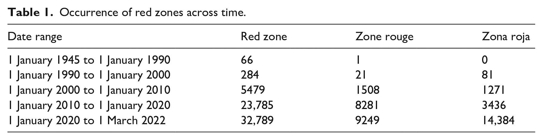
In this section, we zoom out, charting the transversal deployment of red zones across diverse fields of security via a news database search, using the Factiva database, coupled with an extensive literature review to reveal the diverse forms in which red zones are deployed. To map the instances of red-zoning, we conducted a search, filtering the subject ‘political/general news’ and the terms ‘red zone’, ‘zone rouge’ and ‘zona roja’ 3 that was cross-referenced by an extensive literature review. The database search revealed an increased frequency of the term in recent times, with an initial incremental increase in mentions from the 1990s onwards and an explosion over the last two years associated with the widespread use of the term during the COVID-19 pandemic (Table 1). Through this search we identify five interrelated contemporary uses of red-zoning: (1) police interventions (i.e. a secure zone for high profile visitors or events, or as a zone associated with higher risks of criminality); (2) military interventions (i.e. a zone in which rebel groups are active, and a zone associated with higher risks for intervenors); (3) disaster and hazard mapping (i.e. defined by the risk of the area being impacted); (4) spaces associated with the politics of mobility (i.e. a maritime region where pirates are active); and (5) urban no-go zones (i.e. zones established to exclude certain people from certain spaces). As we have argued previously, the purpose of such a mapping exercise is not to identify a singular understanding or practice but to rather chart diverse and sometimes overlapping manifestations. This draws attention to the dispersed and contested situations through which the logics of red-zoning emerge. These logics are continually being negotiated and reconfigured through heterogenous prototypes, connected, we argue, by transversal lines of colour-coding.
Occurrence of red zones across time.
Police interventions
In the field of policing, red zones are associated with targeted and temporary restrictions often in urban spaces that relate to other comparable practices (Neal et al., 2019). A good example is crime hotspots targeted for increased police presence (Kaufman, 2016). For example, ‘Operation Red Zone’ in Boston was based on the assumption that the majority of crime occurs in a reduced geographical area and optimum results could be achieved if federal agencies ‘flood those spots to remove criminals [. . .] federal marshals and immigration agents will swoop into the areas to round up people with arrest warrants or immigration violations’ (Murphy and Smalley, 2005). Another example of this type of practice would be restricted zones established in the context of international meetings and mega-events. These gained attention through their use during G-8 leader summits prior to the Genoa summit that we discuss in more detail in the following section. Red zones in this category are both spaces to be protected (mega-events) and intervened upon (crime hotspots).
Military interventions
In terms of military interventions, red zones often refer to areas where enemy forces are active or zones that are perceived to be insecure and are thus required to be avoided or secured against. There are two key variants of this category of red zone. First, zones where opposing forces are active in the context of counterinsurgency operations. In this field, there is a long history of the use of colour-coded zoning going back to the Malaya Emergency. 4 Red zones appear at least as early as the 1961 Staley Plan in the context of the Vietnam War in which case it is associated with Vietcong and distinguished from yellow zones and blue zones (McCarthy, 1967; see also Khalili, 2012: 201). In the 1980s and 1990s, the term red zone, both in Spanish and English, was used to refer to areas in Peru (Sendero Luminoso) and Colombia (FARC, ELN) where guerrilla groups were active, described by one report as ‘Rebel controlled no-go area[s]’ (McDonough, 1995). In Guatemala, Weizman (2017: 124) notes how military commanders similarly marked many highland regions as red zones in the 1980s, leading to modes of ‘both construction and destruction’. Second, red zones are also employed in the context of peace-building operations. Similar to counterinsurgency, colour-coding is also part of a longer history. Buffer zones in places such as Cyprus and Lebanon were referred to as green lines, whereas in the former Yugoslavia, blue and yellow zones were established around the Croatian peninsula of Prevlaka in the 1990s (UNCR, 1996). The use of the more recognizable distinction between red, yellow and green zones appears to have been first employed by the UN mission in Haiti (Lemay-Hébert, 2018).
Hazards and disaster management
In terms of hazards and disaster management, there are three main variants. First, red zones are employed to designate spaces affected by toxic waste. Early uses of the term red zone include the creation of the ‘zone rouge’ established in Verdun, France following WW1 to mark out an area with unexploded mines, hazardous materials and networks of underground tunnels that was declared uninhabitable, much of it remaining so to this day (Macintyre, 1997). Second, red zones designate disaster affected areas. For example, a red zone was established due to the eruption of Mount St Helens in Skamania County, Washington, USA in 1980. The ‘red zone’ prohibited anyone going within five and later 20 miles of the volcano with road blocks being set up. Unauthorized entry was to be penalized with a fine of $1000 and a year in jail (Brochnau and Parker, 1980). Finally, red zones have been deployed during epidemics and pandemics. Beyond COVID-19, red zones were previously established to control other viruses such as bird flu and Ebola. Similar to the military usage, in these three variants the red zone is defined as a space to be cordoned off or protected against.
Governing mobility
Red zones are also employed to govern mobility. There are two primary uses in this regard. First, colour-coded zoning is used to provide guidelines and restrictions for tourism and business purposes. For example, in the context of the COVID-19 pandemic, Re-open EU developed a colour-coded map ‘that shows the epidemiological situation of EU regions’, with ‘EU countries . . . expected to apply measures to discourage non-essential travel to dark red areas’. 5 Such maps build on previous forms of travel advice visualizing the relative risk of travelling to particular locations, often using colour-codes. 6 Second, red zones are used to indicate areas of dangerous circulation. For example, maritime zones with high rates of piracy have been marked as red zones (Gettleman, 2011). This identification of red zones ‘prompted many ship owners to hire armed guards to sail with them through the red zone’ (Ferreira, 2011). Again, in these instances the red zone is defined as a space of insecurity that should be secured and avoided.
Urban exclusion
In terms of legal restrictions, red zones are established to exclude targeted people from defined areas and/or force them into other designated areas. This can take the form of area restrictions imposed as conditions of release for offenders with suspended sentences (Sylvestre et al., 2019). Urban exclusion can also take the form of redlining, a red-zoning practice developed in the USA in the interwar years, where the government restricted lending to specific neighbourhoods because of social or racial considerations. The Home Owners Loan Corporation devised a complex rating system, through which ‘race and ethnicity’ determined the value of housing to a much greater degree than any structural characteristics (Jackson, 1985). Every majority-black or racially mixed neighbourhood was invariably colour-coded red (Freund, 2007: 114; Jackson, 1985: 196–197). Resistance against redlining practices materialized with the civil-rights movement of the 1960s, when community groups realized that disinvestment was a major cause of community decline (Jackson, 1985: 214).
The purpose of mapping these diverse manifestations of red zones has been to identify the diverse fields of knowledge in which they have been deployed. This is done by mobilizing a mode of critique (Huysmans and Nogueira, 2021) that seeks to elucidate ‘circulations of power and authority’ through transversal connections ‘criss-crossing and generating diverse plural and transnational social and political practices’ (Basaran et al., 2016: 2–3). In our account, the mapping of red zones across diverse fields serves to connect diverse practices that would often be assumed to be separate. Despite differences between the diverse array of manifestations discussed previously, in which red zones are both spaces to be protected and to protect against, there are numerous commonalities that cut across them. These range from forms of mapping and the use of colour to identify insecurities to strategies of fortification and policing to guard against or protect them. At the same time, mapping transversal connections serves to critique paradigmatic accounts of red zones, those that take red zones as reflective of a singular logic of security. By accounting for heterogeneous forms of red-zoning, we are able to appreciate the dispersed and contested situations through which the logics of red-zoning emerge. Security logics are never definitively articulated or worked out but rather are continually being negotiated and reconfigured through discrete interventions and prototypes. To illustrate this further, in the following section we turn to an analysis of a particular scene. This allows us to elucidate how the spatial logics of security develop, are deployed and contested through particular events.
Contestation: Genoa 2001
Having outlined the transversality of red-zoning, we now turn to a scene to illustrate the dispersed, contested practices through which logics of red-zoning develop. We do this by focusing on the red zone as it was implemented in Genoa during the G-8 summit in 2001. Genoa is of particular interest as it was the earliest red-zoning event that received intense scrutiny in the Factiva database search. At the same time, the timing of the Genoa red zone is of particular interest as it comes months before the 9/11 attacks in the USA whilst seemingly anticipating many of the practices which would later be taken as paradigmatic of the war on terror. As such, chronologically, Genoa’s red zone interrupts claims of historical rupture provoked by the so-called ‘war on terror’. Rather than offering an alternative historical periodization, however, we approach the scene of Genoa as a prototype, a nodal point in the development of red-zoning. The scene leads to particular problems being posed and contested solutions being elaborated. The logics of red-zoning emerge through such situations rather than being applied to them. As a result, space is no longer understood as a metaphor of time (Smith, 2008 [1984]) but instead a site of struggle through which contested logics of security are formulated and adapted. Interestingly in this instance, the red zone is the space to be protected. Nevertheless, this does not distance it substantially from other forms of identifying spaces of insecurity and cordoning off zones through colour-coded cartographies, it simply inverts them. The differences between this and other iterations is precisely our point.
As outlined in the opening paragraph of this article, the red zone in Genoa was defined by particular spatial practices. This included shutting down transport terminals and the erection of barriers and checkpoints around the enclosed red zone. The intervention was a complex logistical operation that drew comparisons with military operations and epidemic lockdowns. Leaders were shuttled between the airport, a ship in the port where they stayed and the palace where the meeting was held with contingency plans in place to use helicopters if necessary. After weighing up options, considering an aircraft carrier and cruise ship, George W Bush eventually checked into the Jolly Marina Hotel in the old port, located in the red zone.
The spatial strategies of intervention undoubtedly resonate with the logics of exception, segregation and distancing identified by paradigmatic accounts. Nevertheless, what is lost from such accounts are the practices of contestation through which these are developed. In paradigmatic accounts, the spatial intervention is frozen in time as emblematic of a broader historical condition. In contrast understanding it as an unfinished prototype draws attention to transformation. Indeed, measures in Genoa were implemented only temporarily and were contested intensely, informed by past practices of resistance to such events. After the event, barriers were removed from the city as were border controls at state boundaries. The controversy around them and their impact continued, however. Maintaining an attentiveness to the temporality of red-zoning as an unfinished prototype allows us to draw out three particular moments of contestation before, during and after the event. Following this approach, logics of red-zoning emerge from an ongoing series of battles, debates and controversies rather than appearing fully formed. We show this below by expanding on controversies before, during and after the event.
Just a month before the G-8 meeting, the EU Summit in Gothenburg, Sweden had been marred by violence with police using live ammunition and three protestors being shot. Tension between alter-globalisation protestors and security forces had been steadily rising in the years before the event, particularly since the 1999 protests at the WTO meeting in Seattle, the ‘battle of Seattle’ and at other major summits in Nice and Quebec City. There was a broader questioning around the way in which such summits were to be conducted. Genoa’s mayor Giuseppe Pericu, suggested that it was ‘becoming impossible to hold an international summit anywhere’ (Owen and McGrory, 2001). There were thus questions around how and where such summits could be held. Several options were floated before the event, with suggestions that the conference may be held offshore on warships, cruise vessels or in a well-guarded villa (following the Davos model of the World Economic Forum).
Questions around the kinds of security measures to be taken responded to particular notions of threat. The primary threat identified at the time was international anarchists. Much reporting in the lead up revolved around social panic regarding the Italian group Tute Bianche, the white overalls, with reports detailing how they were preparing protective gear and training to resist the police and storm the red zone. To a lesser extent, there was also concern regarding the potential for Islamic terrorist attacks. A manhunt was underway for an Algerian citizen funded by Osama Bin Laden who it was suspected may be planning an attack (Rashid, 2001). With 100,000 demonstrators expected, the Italian government sought to meet representatives of the Genoa Social Forum, to create a split between peaceful and violent protestors. Peaceful protestors would be permitted in the designated yellow zone that bordered the red zone. Leading into the event, neither the measures to be taken nor the threat that they were to protect against were fully formed but rather the subject of debate and contestation.
During the event itself, contestation intensified. While the summit brought together a vast deployment of security forces in defence of the global economic order, it also served as a meeting point for a diverse group of protestors who developed their own forms of spatial intervention. Protestors were given permission to use schools and other public spaces to camp, the city providing toilets, water and bathing areas. One reporter suggesting that ‘the surrounding counter-summit in many ways mirrors the meeting it seeks to denounce and disrupt – tidy white canvas banquet tents, information booths, brochures, maps, housing (mostly of the squatter/tent variety), scheduled meetings, discussion groups and conferences’ (Stanley, 2001). The primary source of controversy during the event revolved around violent confrontations between police and protestors, resulting in the shooting of protestor Carlo Giuliani. In the days following the event, news emerged about a raid conducted by the police on the headquarters of the Genoa Social Forum where protestors were systematically beaten resulting in numerous hospitalizations. There were also more mundane forms of contestation. There were a range of complaints raised by citizens, who were concerned that their city was being turned into a prison. The majority of shops inside the red zone were forced to close, garbage collection was paused and the everyday life of residents was transformed. One old man was reported saying, ‘this is not a red or yellow zone. . . this is where I live’ (Owen, 2001a). As a prototype, contestation and debate around Genoa’s red zone is not the beginning or end of red-zoning. Rather the event feeds into ongoing debates and approaches for dealing with particular security situations through colour-coded cartographies.
There were numerous efforts to diagnose the failing of security measures at Genoa following the event. These questions all contributed to the broader discussion, already underway in the lead up, around where and how such summits should be held. Some went as far as claiming that ‘the era of grand-scale summit jamborees effectively ended yesterday’ (MacAskill et al., 2001). Many others predicted the simultaneous securitisation and downscaling of future summits. It was suggested that future summits should be held at more remote locations. The 9/11 attacks in the USA occurred in the midst of these debates. In the wake of 9/11, particular concerns were given increased importance and also there was a search for measures to provide security in a diverse array of fields. In this context, it may be possible to track how measures taken in Genoa are picked up and adapted for other purposes. As such, red-zoning in this context serves as a prototype, elements of which are redeployed and adjusted in differing circumstances and to address novel challenges. As we have suggested above, as a prototype, red-zoning as a technology of intervention is not closed off or finished but is constantly transformed and updated through contested situations. In this sense, the fact that the red zone is the zone to be protected in this instance, in contrast to other instances discussed above is not of major importance. Similar strategies can be picked up and deployed with inverted colour codes.
In addition to shedding light on how logics of red-zoning emerge from contested situations, focusing on this scene also provides insight into the chromatology of security. Most obviously, chromatology allows us to underline the importance of colour-coding to regimes of visibility informing government interventions. Colour-coded zoning is employed to make spaces legible for intervention (see Tazzioli, 2018). It ‘distil[s] dynamic social spaces into quantifiable, fixed territorial entities that provide for rationalized strategies of engagement’ (Higate and Henry, 2009: 64). More interestingly from our perspective, however, and in line with the spatial contestation discussed in this section, colour mediates the perception of space and actively shapes the lived experience of red zones giving rise to contestation and novel forms of resistance (Lemay-Hébert, 2018). While depicting a space as red may be taken as a ‘colour act’ that constructs particular understandings of insecurity this also leads to particular experiences and practices of contestation (Higate and Henry, 2009), as already noted above regarding the impact on citizens lives. Another such battle emerged when summit organisers asked residents of the red zone to not hang washing from their balcony during the summit as it gave an ‘unsuitable image’ (Owen, 2001b). This led to outrage from residents, one woman was reported as saying, ‘I don’t care what Berlusconi says. We have been hanging our knickers out to dry in public for generations and I don’t see why we should stop now’. While another says ‘you wait until Saturday and Sunday [. . .] we will hang out as much underwear as we can find’ (Owen, 2001b). The Italian newspaper Corriere della Sera playfully noted the significance of colour-coded contestation in this regard, drawing a link between the white of the Tute Bianche (white overalls) and the white of underwear hung out by residents to suggest that ‘white seems to have become the colour of protest rather than surrender’ (Owen, 2001b).
The protestors themselves were colour-coded in particular ways. Curiously the colour-coding of the perceived threat also changed before and after the event. Much of the reporting in the wake of the event revolved around the so-called Black Bloc that was identified as the primary force behind the disorder. Numerous reports sought to provide insight into who the Black Bloc was. This was in contrast to the primary focus on Tute Bianche (the white overalls) in the lead up to the event. The Black Bloc emerged as an object of concern in the wake of Genoa (Owen and Boyes, 2001).
Conclusion
In this article, we have sought to conceptualize the spatial logics of security by focusing on colour-coded cartographies of (in)security and specifically red-zoning. We have proposed the prototype as a useful device to interrogate the spatial logics of security that builds on International Political Sociology’s interrogation of transversal lines (Basaran et al., 2016) as well as recent scholarship on scandal and controversy (Aradau and McClusky, 2022; Johnson et al., 2022). The notion of the prototype allows us to make two key moves when analysing the spatial logics of security underpinning red-zoning. First, via an attentiveness to the chromatology of security (Anderson et al., 2015) when focusing of red-zoning, we zoom out and track the transversality of spatial forms, bringing diverse forms of security mapping and forms of intervention into the same analytical frame. Second, zooming in on a specific scene, we highlight how spatial logics of security are not closed off but rather formulated and transformed through moments of contestation.
In doing so, we move beyond paradigmatic accounts that mobilize space as a metaphor of time, and critiques of these that mobilize space against time. Rather than taking red-zoning as paradigmatic of particular historical periods, that is taking space as a metaphor of time, we have sought to map out the diverse and contested geographies from which red-zoning emerges. The tools of red-zoning are constantly picked up, adapted and transformed as a prototype as they circulate through transversal connections and contested situations. Applied to colour-coded cartographies of insecurity this also provides a new entry point into the chromatology of security. While meaning making and ‘colour acts’ undoubtedly play a role in red-zoning, and the colour red is deployed to make space legible for security interventions, colour-coding also makes specific forms of contestation possible (Lemay-Hébert, 2018). In particular, we have noted how colour-coding mediates perception of space and leads to practices of contestation. When read in relation to histories of segregation and the racialization of space, such forms of contestation resonate with colonial lineages of colour-coding (Lemay-Hébert and Jerrems 2023) that warrant further investigation in the nascent scholarship on the chromatology of security.
Footnotes
Acknowledgements
Our thanks and gratitude are due to the Grupo de Estudios de Relaciones Internacionales of the Universidad Autónoma de Madrid for inviting us to present an early draft in June 2022 and particularly Ángela Iranzo Dosdad, Itziar Ruiz-Giménez Arrieta, Marta Iñiguez de Heredia and Sergio Caballero for their detailed feedback. We would also like to thank colleagues from the Royal Military College in Saint-Jean (Canada), especially from the Centre for secuRITy and crIsis governanCe (CRITIC), for inviting us to present a draft version of this article in November 2022. Special thanks to Bruno Charbonneau and Chantal Lavallée for the invitation and comments on the article. A draft version of this article was also presented in November 2022 at the University of Quebec at Montreal (Raoul-Dandurand Chair), the University of Montreal (Centre d’Études et de Recherches Internationales), and at the New Directions in Political Geography Workshop, Macquarie University. We are varying our name order as part of a series of articles, with the corresponding author listed first. Equal authorship is implied.
Funding
This work was supported by the Australian Research Council Discovery Grant (DP210101186) ‘The Cartography of Peace: Security Zones, Colour Codes and Everyday Life’.