
Abstract
In this paper, we develop an account of engaged practice of coastal conservation groups with seasonalities on the Coromandel Peninsula in New Zealand, focusing particularly on the polyrhythmicity of change in its coastal hazardscape. While the hazardousness of a place has often been considered in static terms, we wish here to draw attention to its complex temporalities and highly seasonal nature. We emphasise the multiple exposures that exist within the local environment, in order to understand the seasonal nature of natural hazards and the co-ordination of human activities as a result. Our aim is to understand how natural hazards are seasonally set out and managed. A critical insight emerging from the paper is the idea of beyond-annual seasonalities shaping the dynamism of hazardscapes with implications for disaster risk planning.
Introduction
To what extent do our concepts and experiences of seasons provide insight into the patterned onsets of natural hazards and other semi-regular environmental changes in the wider landscape? Ideas about seasonality structure our experience of natural hazards in different periods of the year, including how we productively deal with them through such practices as planning when we sow, prepare for stormwater, or forage. In other words, ideas about seasonality have been closely tied to anticipatory modes of orienting in time by geographers, anthropologists, and social theorists among others (see e.g., Adam 2005; Hastrup 2016: Edensor et al. 2020); ideas of timely action and timelessness, predictability, but also change, variability and, increasingly, volatility. But while the rhythmicity of phenomena is well established across these and other fields (e.g., climatology, geology. epidemiology), the mainstream body of linked scholarship on hazards, (climate) risk governance, adaptation and resilience has been bounded by a more limited temporal literacy (Bremer et al. 2023a). With some notable exceptions (e.g., Penn et al. 2016), much of this work reduces time to a single linear coordinate of clock time, stretching back into a known past, and forward into an unknown future (see the assessment of Nobert & Pelling, 2017). And across the work that does recognize the rhythmicity and relationality of risks, and the ways communities govern for these, there is rarely a thorough account for the nested ‘panarchy’ of cycles that interact across timescales from the daily to the inter-glacial (Arnall 2023). This paper connects with and extends the literature on natural hazard governance, specifically enriching discussions of how we conceptualise the temporal nature of hazardscapes, advocating for seeing disaster risk as operating at beyond-annual seasonalities.
When ideas about seasonality conform to predictability and expectation, it is often a recipe for disaster; the harvest fails, a sudden cold spell upsets the blooming season, the rain does not arrive as expected to irrigate crops. Seeing natural hazards as seasonal means rethinking disaster risk from being situated in linear time, to seeing them situated in cyclic temporalities, as polyrhythmic. Seasonal time is paradigmatic of cyclical thinking, and societies have long defined ‘seasons’ as a temporal framework for setting some order and predictability to the recurrence of hazardous rhythmic patterns, with names like ‘typhoon season’, ‘dry season’, ‘wet season’, ‘tornado season’, all specific to a place or region (Bremer and Wardekker, 2024). On one hand, communities often become accustomed to and prepared for these periods, seeing only extreme deviations from the norm as potentially disastrous. In northeast Bangladesh, for example, the flooding associated with summer rainfall is an essential pattern of social life, a period when the community becomes amphibious (Bremer et al., 2023b). On the other hand, cyclic temporalities can also come into alignment in surprising ways that can amplify the impact of hazards and the exposure and vulnerability of communities: a so-called ‘perfect storm’ scenario where a number of factors intersect to produce a more intense hazard than expected for the season.
A typical example of beyond-annual and polyrhythmic seasonal dynamics is visible in El Niño and La Niña (as part of the Southern Oscillation, collectively known as ENSO). ENSOs’ warm or cold extremes manifest as an irregular yet somewhat cyclical phenomenon occurring every few years in the Pacific Ocean, affecting weather and hazard patterns in different regions of the world through what has been labelled ‘teleconnections’ (Glantz et al., 1991). However, it is also vital to keep in mind that natural hazards are not only reckoned in environmental rhythms. It is important to see seasonal hazards as simultaneously determined by social rhythms, from people's timings of mobility and livelihoods to rhythms of development and land use, political cycles and more: as practices and habits that may be better or worse tailored to the rhythms of the hazardscape.
In this paper, we argue that disaster scholarship could benefit from considering the seasonal complexities of hazardscapes and social practices, with an emphasis on the polyrhythmic nature of seasonalities. We illustrate this argument through a case study of the sub-tropical seasonality of locally manifest natural hazards on the Kūaotunu Peninsula in New Zealand, where we stress the multiplicity of exposures that exist in the local environment, to understand seasons in relation to ‘the hazardousness of a place’ (Hewitt and Burton, 1971). Our aim is to understand how natural hazards and their temporalities are seasonally orientated and managed, while considering what the seasonality of a hazardscape might imply for prevalent social practices. We specifically focus here on the organised practices of coastal conservation groups on the Coromandel and how these groups relate to expectations of seasonal environmental changes in the hazardscape.
This paper is structured as follows: in the next section, we conceptualise natural hazards in the context of their seasonal temporalities; in the third section, we elaborate on the coastal communities of the Kūaotunu Peninsula, which experiences multiple temporal layers of seasonal phenomena and is characterised by a dynamic hazard landscape; in the last and concluding section of the paper, we reflect further on the main points raised and their implications for scholarship on seasonality, environmental change and natural disasters.
Natural hazards, temporalities, and seasonal dynamics
From a plethora of natural phenomena routinely taking place in locations all over the world, only a few are considered potentially hazardous or threatening to human inhabitants. Natural hazards are associated with potentially dangerous phenomena that unfold in the environment around us, such as earthquakes, landslides or storms. Importantly, natural hazards do not necessarily become disasters, as this critically depends on people being exposed and whether they are able to avoid, mitigate or prepare for the risk. After all, ‘whether a disaster unfolds as a consequence of an earthquake, for example, depends on [vulnerabilities] in the population and the state of the built environment’ – in other words, ‘disasters cannot be equated to the hazard’ (Hilhorst and Bankoff, 2022: 1). In this sense, disasters are not benign, neutral or void of agency (Oliver-Smith, 2004, 2002).
Regardless of the kind of agency considered, the human dimension is clear, demanding that we also devote attention to understanding not only how disasters affect society but also the ‘actions and processes which are creating the conditions for disaster’ (Dickinson and Burton, 2022: 203). A temporal perspective can help us avoid both the reduction of disasters to isolated ‘events’ and an eventual vs processual dichotomy (Kreps, 1984). While conceptualisations of disasters have critiqued event-based understandings, the tendency is to consider disaster temporalities in terms of the long processes preceding ‘the event’ and the ‘long shadows’ disasters cast (Hsu, 2019; Kelman, 2022). Shifting our attention to the unfolding of disaster potentialities in the landscape (in the wider sense of the term) enables a focus on how hazardous futures might emerge at ‘different velocities, intensities and extensions – that different social actors try to know, tame, harness or manipulate’ (D’Angelo and Pijpers, 2018: 215). This implies considering the life-course or ‘social life’ of disaster risks (Sørensen and Albris, 2016: 66), from their emergence and gradual unfolding in the environment to their detection and social imagination, whether as exceptional departures from normal expectations or as part of the wider seasonal or decadal sense of expectation.
Natural hazards have long been temporally charted by seasonal cycles (Kwiecien et al., 2022; Marino and Lazrus, 2016). Societies have defined periods when, for instance, climatological and hydrological hazards occur with greater frequency and intensity. Critical infrastructure is often built with such thresholds in mind, e.g., for a ‘100-year flood’ (for a problematisation of such interval-based understandings, see Lee et al., 2021), and failing to dimension them adequately is a major cause of disruption and disaster (Cruz, 2014). While a drizzly or windy day is experienced simply as weather, it is only in the event of material destruction or a potential for loss that we come to embody weather as menacing. Increasingly, we expect warnings of severe manifestations of weather to cushion us against their adverse impacts. This expectation arguably leads to a seasonal sense of associated hydro-meteorological hazards, as they often (albeit not perfectly) conform to seasonal patterns. But seasonal rhythms ‘return with difference’ (Lefebvre et al., 1999); no two seasons are identical, as rhythms shift and interact relative to each other, across time scales. Seasonal patterns are not only produced by annual fluctuations in solar radiation or phenological cycles, for instance, but also in how they affect daily cycles (circadian rhythms) or are themselves turning in the context of longer wave, interannual cycles or, indeed, to zoom out further, the longue durée cycles of human civilisation and geology. And this complicates what communities relate to disaster risks. An example of a more complex seasonality is the onset of El Niño warm events and La Niña cold events in the Pacific Ocean, where Staupe-Delgado and Glantz (2017: 1569) note that: Forecasting the onset of El Niño and La Niña events is arguably still at the experimental stage. Despite considerable improvements in monitoring the phenomenon, its behaviour continues to surprise oceanographers and meteorologists, not to mention disaster planners. For example, scientists believed a strong El Niño would manifest in 2014 as many of its key characteristics started to appear in the central Pacific Ocean. However, it failed to manifest because the warming sea surface did not trigger a change in the atmospheric component of the phenomenon. Later that year the forecast community correctly forecast the extraordinary El Niño of 2015–16 […] Warm events of this magnitude tend to appear about 15 years apart, the last strong one being in 1997–98.
From the perspective of a place's seasonality and hazardousness, it is important to recognise that its risk landscape is not reducible to the material reality of natural hazard phenomena or vulnerabilities in the built environment (Khan et al., 2012). We also recognise that there is a considerable constructivistic aspect to disaster risk, where culture plays a major role in shaping our practices. Insofar as cultural frameworks of seasons affect how people think, feel and act, they will condition how populations relate (and respond) to disasters in a place. Phenomenologically, David Seamon (2018: 2) sees the concept of place in terms of ‘any environmental locus that gathers human experiences, actions, and meanings spatially and temporally’. Clearly, this experience can include any recurring natural phenomena or hazards. Experientially speaking, then, places can be: multivalent in their constitution and complex in their dynamics. On the one hand, places can be liked, cherished, and loved; on the other hand, they can be disliked, distrusted, and feared. For the persons and groups involved, a place can invoke a wide range of supportive, neutral, or undermining actions, experiences, and memories. (ibid.)
In cultural geography, the idea of landscape has been approached in diverse ways that are also usefully employed in the context of hazards and change. Landscapes can be seen first as rooted in long processes of creating and passing on material culture, second as constituting the social spaces that people inhabit as part of everyday life, third, as ways of knowing and uncovering practices and meanings and, lastly, as a critical concept for understanding the imposition of visions of place making by powerful actors (Mustafa, 2005; Yamane, 2009). In other words, landscapes (including landscapes of hazardousness and risk) change over time due to environmental change, often related to specific uses of the landscape, including natural resource extraction, construction and other drivers of land-use change, also affecting the hazardscape (Müller-Mahn et al., 2018; Macnaghten, 2003). Landscapes not only change in an objective sense, however, they are also experienced individually by each inhabitant, and the experience of landscape is dynamic. For example, a landscape can look different depending on our mood (Thonhauser, 2021) or if we have come to understand that certain risks are associated with inhabiting it. From a morphological (physical, material) viewpoint, landscapes or places are not static, they change and are always in movement at speeds ranging from the geological to the social processes of land-use change or even perceptual change (Furia, 2022). Landscapes are, as Adam (2005) conceptualised them, ‘timescapes’. So put, there is not a clear-cut objective or subjective distinction when morphologically considering the temporalities of environmental change and rhythms; the social and natural blend into what could phenomenologically be considered ‘world’ (i.e., the reality that appears to us and is meaningful to us as human beings, as inhabitants of place).
There is an interdisciplinary scholarship that has been making sense of places as timescapes, tressing the entangledness of social and environmental rhythms, which we draw inspiration and guidance from in this study. These include anthropology (Ingold, 2021; Krause, 2013; Tsing, 2015), philosophy (Bastian, 2012), geography (Edensor, 2016), history (Kwiecien et al., 2022), and social theory (Adam, 2005; Lefebvre et al., 1999). Suffice to note here that it is commonplace in the social sciences and humanities to see time as multiple, contextual and relational.
Against this background, we argue that there is analytical purchase in thinking of certain natural hazards as demonstrating a form of seasonality, as emerging at the intersection of intertwined environmental and social rhythms, cycling at multiple time scales, and manifesting in annually repeating rhythmic patterns with a propensity for material damage in a place. We can visualise this through the metaphor of a combination lock opened by turning a numbered dial left and right. When those cycles come into alignment, the conditions are created for disaster. This conceptualisation may prove useful for natural hazard scholarship and practice, in that it (i) captures the dynamic interaction between environmental and social temporalities constituting place; (ii) corresponds with how (some) societies conceive of seasonality of risk; and (iii) enhances societies’ anticipation and preparedness, by helping people to take notice of the temporal rhythms giving rise to hazards, and making visible periods of the year when populations are particularly exposed and vulnerable (Penn et al., 2016). Importantly, this means looking beyond a simple anticipatory category, of a ‘storm season’ for instance, to see these seasons as situated in a tangle of ‘nested’ cycles.
Anticipating and practising seasonal rhythms and environmental change
Environmental practices are informed by temporal frameworks and anticipated through memory and interpretation of the past (Fincher et al., 2014). To the extent that our practices are enacted in the present, many are also oriented to the future, and they are also mediated through our engagement with prognoses such as weather forecasts, disaster early warning and climate scenarios (Granjou et al., 2017), all of which shape our lived experience of the current and coming environment. Expectations of an emerging future, not yet given to our senses nor our practical engagement with the local environment, may still become part of practice through the fear of future hardships. In this context, ‘to say that something is looming is to recognise that something, while still yet indefinite in form, is imposing its impending presence upon us’ (Throop, 2022: 69). What is seen as an inevitable emerging presence shapes our sense of possibility (ibid.). Such presences, while not necessarily material, may be described as ‘atmospheric’ (Anderson, 2009). We recognise atmospheric anticipations when we ‘prepare for winter’ because it seems to be ‘around the corner’, also when we rush out for the harvest because we sense a potential early end to the season, or when we experience a sense of looming calm which is taken to signify the imminent arrival of a storm.
Anticipation is a major aspect of everyday life and phenomenological existence as well as practice. Everyday situations are full of ‘practical and reflective engagements’ of an anticipatory character (Stephan and Flaherty, 2019), triggering evasive or opportunistic changes in practice. Ideas about the future and our experience of environmental changes in the past, present and future are often narrated through oral histories in specific places, which have been labelled ‘time stories’ (Fincher et al., 2014). Indeed, environmental knowledge (including practical knowledge) is very much shaped by oral histories that are rarely recorded in formal accounts (Williams and Riley, 2020). To the extent that they are written down, such accounts are often incomplete, existing in such crude forms as accounting records, specific measures of rainfall, yields or similar. Focusing particularly on the polyrhythmicity of seasons involved in environmental practices on the Coromandel Peninsula can provide a way of interpreting those local oral histories that do exist of seasons past and build anticipation for future seasons.
A volatile hazardscape: the Kūaotunu Peninsula on the Coromandel Peninsula
Locating Kūaotunu
The Coromandel Peninsula, a spectacular mountain-to-sea landscape, is located on the east coast of New Zealand's North Island (see Figure 1). With approximately 400 km of coastline hosting 365 swimming beaches - one for every day of the year - its elevated interior forms a range covered in patches of native forest, largely protected within conservation estate. Renowned as a tourist destination with a high level of second-home ownership among its beach settlements, the Coromandel's permanent population incorporates creative and eco-based lifestyles, as well as intergenerational farming families and enclaves of multiple indigenous iwi (Māori tribes). The Kūaotunu Peninsula, located on the Coromandel's eastern seaboard, captures all of these elements as a peninsula within a peninsula. With its succession of north-facing sandy beaches becoming increasingly remote, the Kūaotunu Peninsula is a popular getaway for second-home owners – particularly during the peak summer season – alongside a base population of mainly retirees.
Motivated by common concerns for their environment, a number of Kūaotunu locals are voluntarily involved in a diverse range of grassroots conservation initiatives, alongside statutory national, regional and local government organisations. ‘CoastCare’, for example, is a joint venture, involving municipal and regional government and conservancies, to care for and protect dune systems on beaches all along the Coromandel Peninsula (and the wider Waikato Region it is located in). In addition, the Kūaotunu Peninsula has several independent dedicated wetland conservation groups associated with its main watercourses, while also being the ancestral homeland to several indigenous iwi, each with their own enduring custodianship. This study focused on three of these independent coastal conservation groups, who have self-organised with an ambition to restore thriving and robust coastal ecosystems, for both their intrinsic value and the ecosystem services they provide, not least how they mitigate the effects of coastal erosion and flooding. This paper focuses on coastal conservation group members’ perceived seasonality of coastal flooding and erosion hazards, including a regard for the rhythmicity of their work to address them. This is important because, if the tempo of coastal conservation activities falls out of step with hazards, it can amplify the exposure of coastal communities.
Ethnographic study into the temporal rhythms of CoastCare groups
The Kūaotunu research presented here is part of a larger ethnographic study conducted by one co-author (KZ) over a period of three years (2021–2023), investigating the seasonal patterns of volunteer coastal conservation groups’ practical engagement with the local environment. The fieldwork was guided by human geography perspectives on relational phenomenology for studying knowledges and practices, cultural representations, and politics of place (Ingold 2021; MacGillivray & Franklin 2015). Critical ethnographies of institutions likewise provided methodological handholds for understanding CoastCare organisations (Bremer et al. 2021; Madison 2011; Smith 2005). At the same time, the study adopted a transdisciplinary approach to intervening in conservation groups to collaboratively and critically reflect on seasonal practices with them, and how they do (or ought to) transform with global environmental change (Meisch et al. 2022; Pohl 2008). The research drew on a mixed toolbox of (qualitative) methods (Lareau 2021).
The researcher embedded themselves as a participant observer in the activities of three conservation groups – the Otama Reserve Group, Kūaotunu Dunecare Group, and Rings Beach - over 2021–2022, taking part in meetings, planting days, checking pest traplines, and social activities according to the irregular rhythm of these events, but at least monthly. Observation was augmented with individual and focus group interviews, autoethnographic observations, photography and video recordings, and document analysis. Interviews were also conducted with individuals and organisations linked to the activities of these three conservation groups, including neighbouring groups (Opito Bay and Rings Beach CoastCare, local government, Ngati Huarere ki Whangapoua – the Māori tribe local to Whangapoua – and the Mercury Bay Environment Trust which grows seedlings for CoastCare groups). In total this amounted to more than 40 interviews, semi-structured as ‘narrative interviews’ to elicit stories of seasonality, lasting approximately one hour recorded and transcribed for analysis. In April 2023, the fieldwork concluded with a one-day workshop, assembling CoastCare and independent conservators and local government policy-makers to discuss the 2022/2023 cyclones and lessons learned for the municipalities Shoreline Management Plan. The case study presented here draws mainly on participant observations and interviews, with pseudonyms used to attribute quotes to interviewees.
Hazards and seasonalities on Coromandel
The coastal communities of the Coromandel's Kūaotunu Peninsula are clustered around a string of north-facing sandy beaches associated with short steep catchments. These coastal settlements have long been vulnerable to periodic inundation and erosion hazards, specifically during storm events, when they are frequently isolated through a combination of flooding and landslips affecting the local road network.
Facing these well-known hazards, one key mitigation strategy of conservation groups in Kūaotunu communities has been to restore natural dune systems as dynamic buffers to the eroding forces of wave action. This is principally achieved by replanting the dunes with native plants that naturally stabilise the sand and hold it in place against storm wave action. An overlapping concern has been to restore the ecological functionality of adjacent wetland and bush habitats – and thus bolster their natural resilience. The way conservationists think about their exposure to coastal erosion and inundation hazards is, to different degrees, linked to the perceived robustness of their coastal management. It is also linked to the recent disastrous events, which draw attention to these hazards, making them both noticeable and alarming.
The summer of 2018 delivered a ‘weather bomb’ in January that affected northern and central areas of Aotearoa New Zealand (ANZ). On the Coromandel, the coincidence of the deep low-pressure system with king tides resulted in extensive damage to low-lying coastal areas, including the main populations of Thames and Whitianga. After years of inaction, the widespread damage that this extreme storm event caused across the district effectively instigated the Thames Coromandel District Council's (TCDC) in the following year, and TCDC appointed their first dedicated Coastal Scientist in 2020.
Then, in January/February 2023, ex-cyclone Hale and cyclone Gabrielle struck less than a month apart with disastrous effect, causing millions of dollars of damage. In addition to flooding of low-lying areas through accumulated rainfall, road networks were impacted by countless landslips. The dramatic failing of the arterial State Highway 25a, which strategically traverses the Coromandel Ranges between Kopu and Hikuai, has substantially extended the journey times to the east coast. This is couched in a wider discussion – amongst local government, media and NGOs – of long-term environmental change (particularly climate change) that threatens to exacerbate Kūaotunu communities’ exposure to flooding and erosion hazards: will sea level rise lead to a greater likelihood of inundation? Will warmer sea temperatures bring more cyclones? Will rain events become even more intense, leading to more dramatic flooding and slips? And how will changes in land use – from building new houses along the dunes to replacing bush with plantation forestry that is periodically clear-felled or the return of uneconomic farms to scrub and bush – affect this flooding hazard?
Of interest in this article is how Kūaotunu's communities, and specifically local independent conservation groups, talk about the timing of these flooding and erosion hazards. While many Kūaotunu beaches are in an accretion or stable phase, and communities there feel less exposed to these hazards, people we spoke to inevitably brought up coastal hazards as an issue for the wider Coromandel, on road networks for example. Many we talked to discussed (directly or indirectly) hazards as seasonal or cyclic, returning each year in defined time periods, but suggested that the magnitude of a particular event was determined by the coincidence of multiple temporalities or rhythms at multiple time scales. Indeed, it is through these illustrative events – such as the string of cyclones in summer 2022/2023 – that the particularity of each seasonal cycle becomes visible, along with the ways that seasons change. When a polyphony of rhythms came to align or overlap in a particular period, this created the conditions for a disaster and amplified the impact on people. In this sense, disasters are a result of ‘bad timing’, for example (see below) when a storm surge coincides with a king tide, during a period when a beach's sand budget is already depleted and holidaymakers are gathered there in vulnerable tents and caravans.
Seeing disasters as polyrhythmic means recognising the multiple rhythms of motion and change (what we call temporalities) that course through the places where people live, at different time scales (from the daily tides to geological cycles on a scale of millions of years). It means seeing temporalities relationally, as inter-penetrating and affecting each other. Sometimes they sync as a plant's growing season matches a climatic season, and at other times they clash, as the tourist season clashes with migratory birds nesting on beaches. And it means seeing temporalities constantly shifting relative to each other, moving in and out of stability and attunement as conditions change. Consider how anthropogenic climatic change is rapidly changing seasonal patterns of weather phenomena, with direct relational influences on other temporalities – of phenology or hydrology for example. Or consider how changes in the cycles of human land use on the Coromandel are affecting the rhythms of water and sediment loads entering the coastal system.
The polyrhythmicity of flooding and erosion hazards
In discussing and carrying out their conservation activities, interviewees discussed the complex relations between social and environmental temporalities as rhythmic cycles, which we tease out below, while maintaining an appreciation for the relational links between them. We start with three physical environmental rhythms, before focusing on three socio-cultural rhythms.
Rhythms of weather and climate
There is an annual cyclicity to the weather patterns affecting Kūaotunu. Settlements are quite favourably sheltered from southern and western weather and, with their north-facing aspect, somewhat sheltered from the easterly weather coming off the Pacific Ocean. This sees the beaches mainly vulnerable to summer cyclones form the north and weather (e.g., winter storm) events coming from the northeast. Interviewees categorised storms according to different seasonal periods. TCDC coastal scientist, Jesse, discussed the predominantly easterly winter storm surges as being highly destructive to the Coromandel's east-coast beaches, many of which are in a sand net erosion rhythm: “Generally, the wintertime is the most destructive for the east coast. You get your successive storm events in the wintertime and particularly with La Nina. So, it's back-to-back storm events that take away all the sand, and it doesn’t come back.” Successive storm events reported in the winter of 2008 and summer 2009 acted as key catalysts for initiating dune restoration projects around the Coromandel's east coast (see Figure 2).
Spring brings extreme weather conditions to the east coast, specifically high winds. According to Lewis of Ngati Huarere ki Whangapoua – the Māori tribe local to Whangapoua – high winds are inevitably expected to follow the winter rains: “So, we always have massive rainfall here late June through to September, around the equinox, and then we get the high winds. So, you’ve got to plan [your planting activities] around those winds too.” In recent years, Otama Reserves Group volunteer, Phil, recalls extreme weather events affecting the Otama wetland in Spring. This notably included a large storm event hitting Kūaotunu with force in September 2019, resulting in widespread flooding.
Summer can bring tropical cyclones, and the north-facing aspect of Kūaotunu's beaches renders them more exposed. Typically, however, the timing of summer cyclones during the beach accretion phase will not result in significant erosion, as the TCDC coastal scientist explains: “In summertime, you might get a tropical cyclone, but – depending on the severity of that cyclone – usually there's enough sand on the beaches to buffer the energy, so that the toe of the dune doesn’t erode.”
Respondents recognised the effect of the cycles of La Niña and El Niño on the storms impacting Kūaotunu's beach settlements. While often portrayed as a pendulum between El Niño and La Niña events, the peninsula has just experienced three successive years of La Niña dynamics. Joy, who grows dune plants at a nursery in Whakatane, linked dangerous cyclones to La Niña: “So, my big worry for this summer, for instance, is: are we going to have any cyclones? We’re in La Niña, we’re going to get a warm wet period.” Joy went on to discuss the implications of a ‘warm and wet period’ for dune plantings, a topic also raised by Dan in relation to Otama wetland hydrology and ecosystem health: “So, when I think of La Niña (well, I think it's La Niña), we get a lot more rain. And it's sort of very wet all at once and we get a lot of easterlies. It's sort of windy, and it's constant showers coming over.”
Rhythms at the interface of the ocean and the land
The rhythms of the ocean influence community exposure to coastal flooding, with the daily ebb and flow of the tides and their monthly/lunar cycles. The coincidence of a king tide with a high rainfall storm event in 2018 was specifically devastating to the Coromandel's coastal settlements. Interviewees from the Kūaotunu Peninsula also reported the seasonal warming and cooling of ocean waters, which they saw as having an impact on summer cyclones, for example, but also on the ecosystems that buffered the coastline against these storms. As Geraldine noted at Rings Beach: “We get that pink fluffy, horrible seaweed in the water now because the water temperature is warmer. In all the years I’ve been here, the last two or three are the first time we’ve seen that.” Lewis, of Ngati Huarere ki Whangapoua, talked of closely monitoring the tides, ocean temperature and weather in intuitively harvesting from local shellfish populations: “When you go through the calendar and see the high tides, I keep an eye out for us because you can get Pauas from here to there. If it's a sunny day out on the water, the sun will bake them off and they’ll fall on their back in the sand.”
The rhythms of coastal geomorphology were mainly discussed in relation to the constantly shifting sandscape along the beaches and the phases of accretion and erosion that come with the tides, currents, and storms around the year: “Sand comes and goes, the movement is phenomenal from one day to the next. […] It changes from week to week – and the dune shape” (Sam, Otama). According to data published on the Waikato Regional Council website, Kūaotunu Peninsula's northern beaches are generally within a steady phase of recovery following severe storm events in 2006 and 2008 (associated with La Niña phases). However, Rings Beach and Opito Bay are noted as relatively stable – with less than 5-m movement over 40 years of monitoring. Jill at Otama explains these longer-term movements of sand on- and offshore: In July 2008, we had a winter weather event. I wasn’t living here then and came down the weekend afterwards […] to the beach. It wasn’t there! There was not a grain of sand. It was only rocks. And I was beside myself. I was calling Department of Conservation to come down here and do something for our trees. But the guy said to me, ‘That sand will just be sitting out there and I’ll bet by Christmas that it's all back again.’ And sure enough it was back.
At Otama, the seasonality of the sandscape ‘blocks off’ the Otama River mouth with sediment over summer because of its reduced flow relative to depositional wave action, backing up stagnant water over prolonged periods during dry summer months until it is released through a storm event in winter. The periodic flooding of the wetland provides habitat for many native wetland bird species. “The opening and closing off of that lagoon has a massive impact on the whole ecosystem” (Phil, Otama).
Far from a static backdrop, the cycles of mountain building and erosion on ultra-long geological timescales are relevant to the coastal hazards at Kūaotunu; the hills are in constant movement, though less easily apprehended. The sedimentary rocks of the Coromandel hills are gradually being pushed up out of the ocean by tectonic activity, while constantly subjected to erosion through hydrological processes – the erosion of rivers and landslides. These processes transport a steady supply of sediment, along waterways, to Kūaotunu beaches, with the configurations of the landscapes –- in both scale and character – influencing the morphologies of the beaches themselves. Although native wetlands would originally have featured behind each of Kūaotunu beaches, nestled behind the dune systems, only Otama and Rings Beach have retained ecologically significant wetland habitats.
Ecological rhythms
In carrying out dune restoration and wetland management, coastal conservation group members expressed a shared belief that healthy coastal ecosystems are a critical factor in a coastline's resilience to withstand storm impacts. In this sense, ecological rhythms, and the life cycles of key plant species, were deemed important. The annual growing cycles of native plants were observed in relation to when they grow best – over winter – in order to establish themselves prior to the high spring winds and the potential for summer drought. This was likewise essential to the timing of dune plantings and the removal of introduced or pest species: “The reason is that the Spinafex and Pingao need to get their roots down deep enough to get good moisture levels over their first summer” (Joy, Whakatane). This means that, if plants cannot be established by summer, they will not function as an effective buffer against tropical cyclones. Recognising plants’ seeding cycles was likewise important for harvesting seeds to propagate in nurseries. In bush restoration projects, this comes with the added challenges that seeding rhythms vary from year to year, so that one can never be sure of which exact period to harvest seeds, and that certain native forest trees flower over longer cycles. “So, the Titoki seeds […] apparently they do [seed] every seventh year” (Alice, Mercury Bay).
Similar insights provided the foundation for many customary Māori tohu (natural signs), through which “plants helped to denote seasons, the time for annual tasks by their flowering, fruits, etc.” (Elsdon, Forest Lore). For Ngāti Huarere, who have customarily harvested kiamoana (seafood) from the Whangapoua Harbour, seasonal timings remain highly contingent on local observations, such as: “when the flax flowers, the kina are fat” (Lewis, Ngati Huarere, Whangapoua). Additionally, the detailed monitoring of plant, bird and aquatic-marine life, alongside weather patterns relative to the lunar calendar (Maramataka) and astrological constellations, traditionally provided multiple references from which changes could be registered and patterns distinguished. These sophisticated systems of signs and calendars also signal the arrival of important migratory birds, such as dotterals (Charadrius morinellus), the swelling of numbers of predator pest species like possums (Didelphidae) or the decline of the prized ‘kaimoana’ species (scallops, for example).
Socio-cultural rhythms of community life
As a popular holiday destination, Kūaotunu's coastlines and communities are significantly affected by the annual tourist season. This extended season loosely matches the warm and dry ‘summer’ months, though it is more determined by the cultural calendar of statutory holidays which bookend the season between Labour weekend in late-October and Easter in April, with a peak around the Christmas/New Year holiday period in late December/early January. Over the tourist season, visitors can quadruple the Coromandel's permanent population of 32,000, filling up holiday homes and campgrounds in what is mockingly referred to as the ‘silly season’. Over this period, services and infrastructure are expanded – shops and cafes open, and there are more frequent social activities – but also strained, and locals come to live in a different ‘mode’ than over the quieter winter months.
For interviewees, there is an undercurrent of tension between the recurring socio-cultural tourist rhythm and the underlying rhythms of the natural environment. Tourism places pressure on local beaches and their associated dune habitats, putting conservation custodians in a protective surveillance mode, as Tara from the municipality notes: “And then the summer season starts, and that's when you just need to make sure that whatever you’ve planted and you’ve managed to maintain so well actually is protected from this massive influx of people.” It can also render communities more exposed to the impacts of summer cyclones, with campgrounds abutting the beach in danger of coastal floods and local road access regularly cut off by landslides and floods. Finally, the fluctuating resident population over the course of the year affects the temporal patterning of coastal management, with some conservation groups voicing hostility towards holiday homeowners. Alec, from Kūaotunu, perceives a link between increased second-home ownership and diminishing environmental custodianship. He sees part-time residents as having a reduced practical commitment to conservation work and divergent environmental values, compared to those of permanent residents: “You get a lot of people come down here to their ‘bach’ [holiday home], and they don’t know what's going on around here.”
It should be noted, however, that not all of community life is patterned by the rhythms of statutory holidays and tourism. Ngati Huarere representatives are actively working to restore customary calendars for prescribing social interaction with the environment, based on Mauturanga Māori, involving interwoven ecological temporalities of the whole catchment system, observed in the seasonal signs or ‘tohu’. The challenge is to reconcile customary and Gregorian calendars.
Land use and infrastructure rhythms
Interviewees discussed the cycles associated with coastal land use, development and infrastructure, and their relative impacts on environmental cycles, with implications for coastal flooding and erosion. Three land uses were most prominent in these discussions. First, the steep catchments cradling Kūaotunu's beaches have been planted to some extent in production pine forestry, introducing a 30–40-year cycle of planting, growing, thinning and clear-felling or harvesting these pines. This land use influences other environmental cycles, particularly affecting levels of erosion and siltation of the waterways and, for one interviewee, also the climate: When the forestry comes off, the skyline will change by 60–70 feet. So, they can predict the weather, but when that forestry is moved, it's all over the show. And then, when they cut the forest over this side […], we get lots of landslides, which affects our [seafood] and our seashore there, and it's possibly why, in our time, the mudflats have turned into sludge. (Lewis)
Second, interviewees discussed the rhythms of residential development along the coastline as periods when conditions are (or are not) favourable to building new holiday homes. They also discussed how, once built, these increasingly dense residential developments affect the beaches’ geomorphology, reducing resilience to erosion. With many of these developments built on top of dune fields, this is altering the dynamic profiles of active beach and dune systems in their natural cycles of erosion and accretion, compromising the dunes’ ability to respond to and recover from periodic erosion events. A third common topic for interviewees was the precarious coastal roads connecting Kūaotunu to larger settlements and the ‘mainland’. Much was made of the ongoing maintenance work required to clear or re-build these roads following successive landslides and flooding, as a rhythm characteristic of life on the peninsula. Indeed, in some instances, this battle to keep roads open has been seen as futile, as for the road between Rings Beach and Matarangi, which was closed by a landslide and never re-opened.
Coastal management rhythms
The annual cycle of coastal management, particularly in planting and maintaining dunes in advance of the principal storm season, affects exposure and vulnerability to coastal flooding and erosion. Erosion associated with summer cyclones is usually readily restored to affected beaches as part of their cyclical (seasonal) sand budgets, which are supported through coastal restoration efforts. But maintaining these restoration programmes takes careful timing and sequencing of activities at the intersection of a tangle of social and ecological temporalities.
Coastal conservation group activities are centred over the autumn and winter periods, as the tourist season comes to an end. The favoured dune plantings – Spinafex and Pingao – need to be planted in winter, in order for their root systems to become established ahead of summer. Consequently, most native dune plantings are planned during June-July in Kūaotunu; for the nurseries supplying plants, this represents a relatively short window of opportunity that requires thorough planning (see Figures 3 and 4). Timing is also linked to organisational and financial calendars, with some groups reliant on funding from government organisations. And it is timed to avoid the hectic tourist season, with conservation work drawing to a close by early December, around the time when the first wave of summer visitors is expected. As the early mornings begin to heat up in December, it becomes increasingly uncomfortable for participants to work in the sun. There are also the practical difficulties of hand pulling weeds from increasingly active beaches – and when many participants are themselves preoccupied with hosting visitors and family.
One task carried out over the summer tourist season is the collection of seeds from native plants for propagation, growing and planting over the winter. Here, interviewees discussed the importance of local knowledge of where plants are, their phenological rhythms and how these rhythms vary: So, you know, when we first started doing this, we spent a long time just walking, looking for where the trees were. Now, we can tell you where the right trees are – where there's 50 Kohekohe. But we have to plan in the seasons to do enough walks…Sometimes, what we expect to happen on the trees doesn’t happen when you expect it to happen. (Kit, Mercury Bay)
Taken together, the case of Kūaotunu's field of independent coastal conservation groups empirically reveals, in detail, the multiplicity of natural and cultural’ rhythms – across timescales – invoked by conservators in describing the coastal hazardscape, and organising the temporal patterning of their activities. Indeed it becomes apparent that a failure to attune to these rhythms (e.g., by planting dunes over summer, or failing to account for the multi-year rhythms of sand budgets), could undermine their ecosystem restoration efforts entirely, echoing work across relevant fields of research (cf. Krause (2013); Arnall (2023).
Concluding reflections: contributions to natural hazards scholarship
In this paper, we have argued for the complexity of seasonal temporalities inherent in natural hazard governance and illustrated our arguments with an account of conservation practices employed in anticipation of coastal erosion and flooding on the Kūaotunu Peninsula in New Zealand. Special attention was given to the myriad exposures present within the local environment, aiming to unravel the seasonal-temporal aspects of natural hazards. One pivotal insight was to see hazards as recurrent according to composite cyclic temporalities, including those associated with seasonality, emerging at the moments where rhythms converge. A second pivotal insight arising from this study is the problematisation of seasonality through the exploration of polyrhythmicity or beyond-annual seasonality, such as ENSO and other oscillations. This suggests that seasonalities manifest themselves at diverse levels and temporal scales beyond the conventional annual cycle, with indirect influences on the behaviour and anomalies in how conventional annual seasonal hazard cycles (such as the ‘storm season’) are manifested.
Although there is a somewhat predictable seasonality to hazards, to anticipate disastrous events, one must consider the alignment of cycles on very different timescales, from the tides to interannual global circulation patterns. In essence, this study hints at recalibrating our interpretation of seasonal patterns, urging scholars and practitioners to incorporate a nuanced comprehension of polyrhythmicity into discussions concerning environmental dynamics. A recognition and examination of the intricate interplay between natural hazards, environmental change and beyond-annual seasonality will be important for climate change adaptation and a better understanding of how people live with and in hazardscapes as part of everyday life.
This paper teased out multiple environmental rhythms that converge to create the conditions for coastal erosion and flooding in Kūaotunu, encompassing meteorological cycles, interannual climatic rhythms and rhythms of oceanographic, geomorphological, geological, hydrological and ecological natures. Annual seasonal patterns affecting Kūaotunu include tropical cyclones during the summer months. The interannual climatic rhythms, specifically the oscillation between La Niña and El Niño events, also shape the storms impacting the beach settlements. Oceanographic rhythms, manifest through daily tides and monthly lunar cycles, significantly influence community exposure to coastal flooding. Coastal geomorphological rhythms, observed in the constantly shifting sandscape, in turn reflect the accretion and erosion phases influenced by tides, currents and storms. Geological and hydrological rhythms, operating on ultra-long geological timescales, contribute to coastal hazards through mountain building, erosion and sediment transport over the long term. Additionally, ecological rhythms, manifest in the life cycles of native plants and animals, play a central role in maintaining a robust coastal ecosystem, able to withstand the impacts of coastal erosion and flooding.
In addition, Kūaotunu's socio-cultural rhythms also shape coastal ways of life, with tourism greatly affecting the dynamics of some of these natural phenomena, as well as disaster risk exposure and vulnerability patterns. This socio-cultural rhythm, driven by statutory holidays and peak tourism, creates tensions with the underlying rhythms of the natural environment. Land use and infrastructure rhythms, exemplified by cycles associated with coastal land use, development and infrastructure, also emerge as significant factors influencing environmental cycles and impacting coastal flooding. The ongoing pine forestry cycles, residential development and associated infrastructure significantly contribute to the modification of catchment environments and the coastal hazardscape in general.
Coastal and natural hazard governance, reflected here in the co-ordinated rhythms of conservation activities, also play an important role in mitigating the exposure and vulnerability to coastal flooding and erosion. Conservation activities are tactically timed during autumn and winter months to avoid the summer tourist season, while practically complying with ecological and organisational timelines. The careful timing of dune restoration programmes is ultimately strategic, requiring contingent synchronisations of social, ecological and financial calendars. This final point – on the need to synchronise governance processes with the social and environmental rhythms giving rise to hazards – recommends more research and practical initiatives to improve the temporal competence of governance organisations and actors. The complexity and layers of these rhythms and their implied governance challenges in Kūaotunu are illustrated in Figure 5.
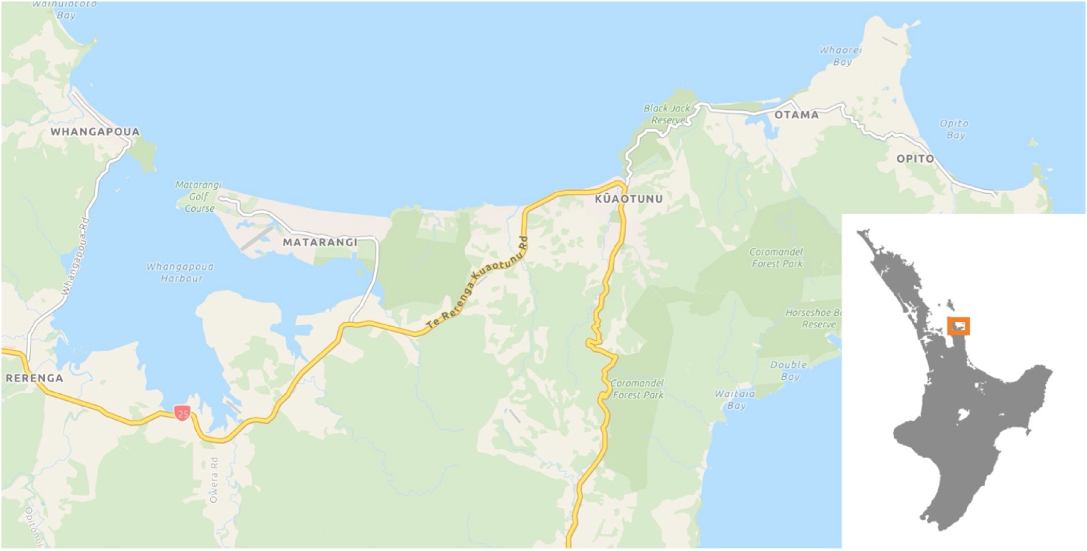
A map of the Kūaotunu Peninsula and showing its location on Aotearoa-New Zealand's North Island. Taken from the Thames Coromandel District Council Smart Maps (https://www.tcdc.govt.nz/Our-Services/SMART-Maps).
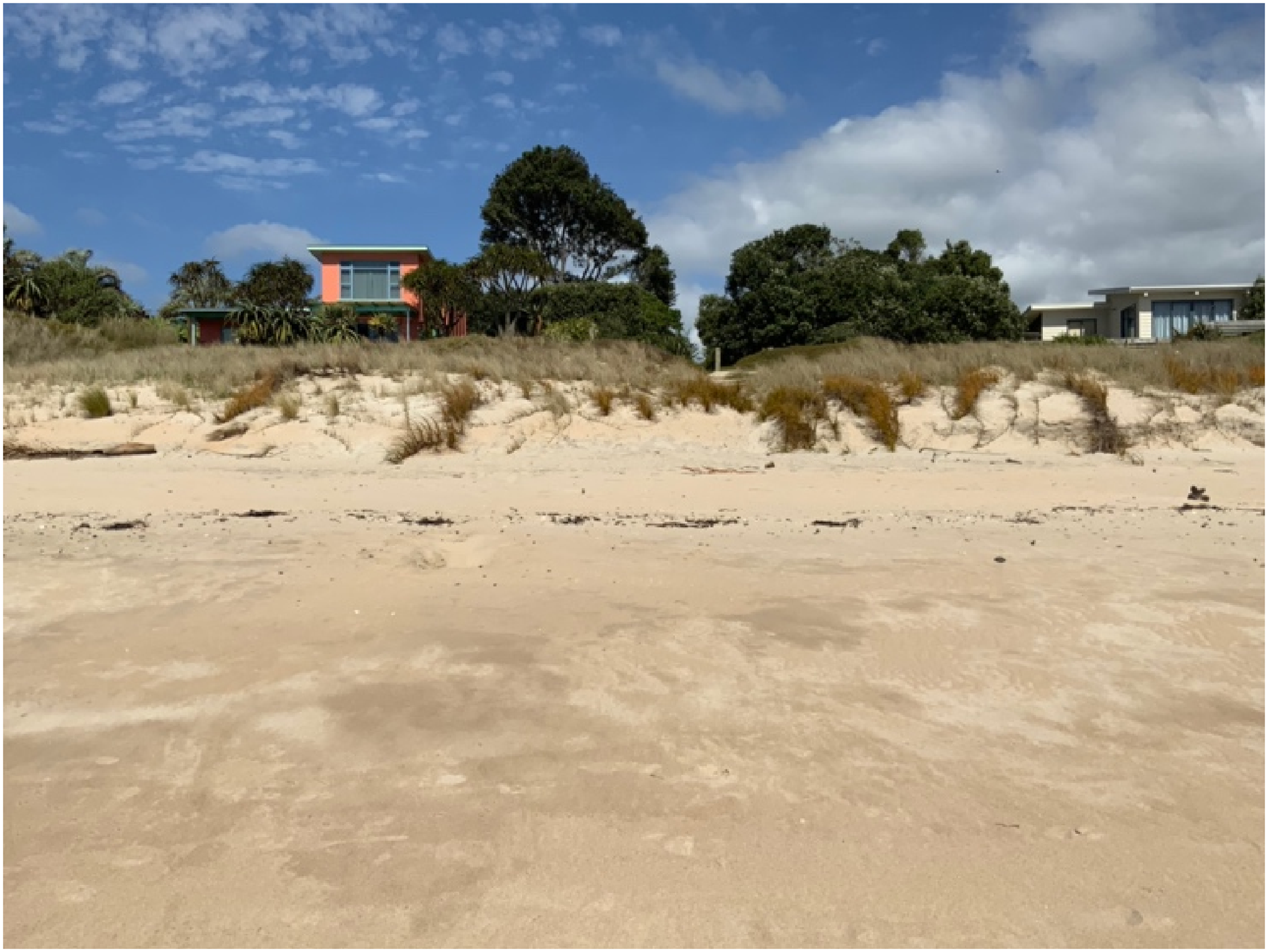
Mitigating exposure to coastal risks: restored dunes defending holiday homes at Kuaotunu East Beach, as seen from the current shoreline (Photo: KZ).
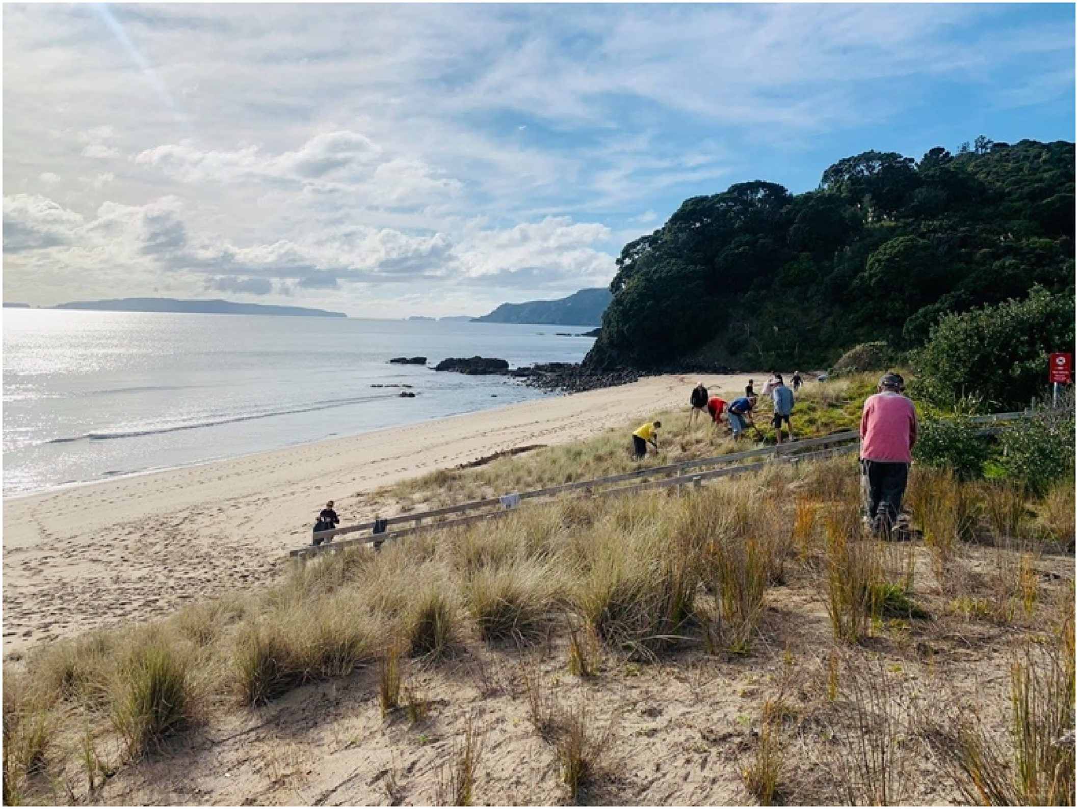
An annual residents dune restoration planting day over the (former) Queens Birthday weekend (celebrated on the first Monday of June) at Rings Beach (Photo: KZ).
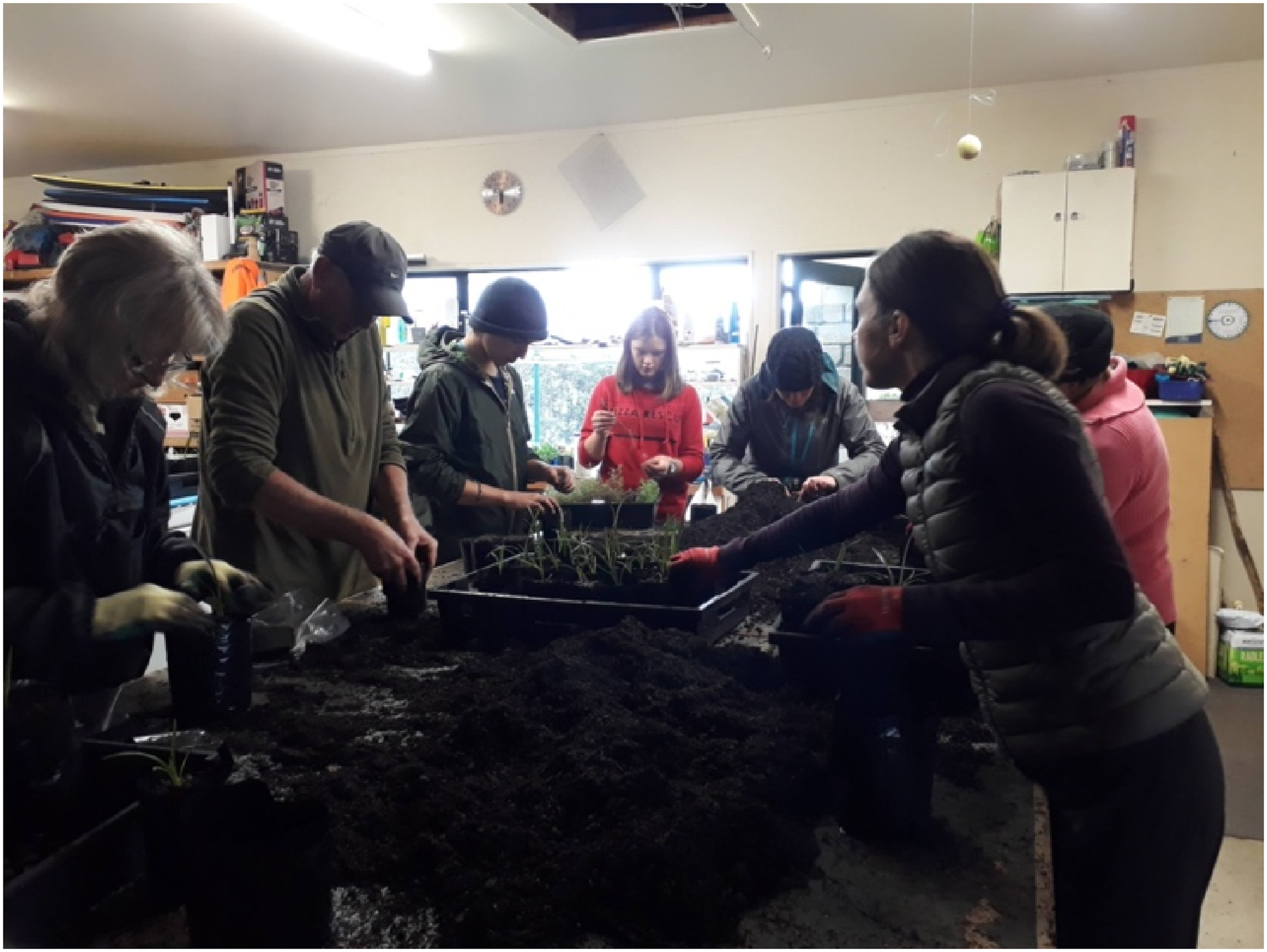
Local volunteers at the Mercury Bay Environment Trust collectively pot native dune plants over autumn for the following years planting season (Photo: KZ).
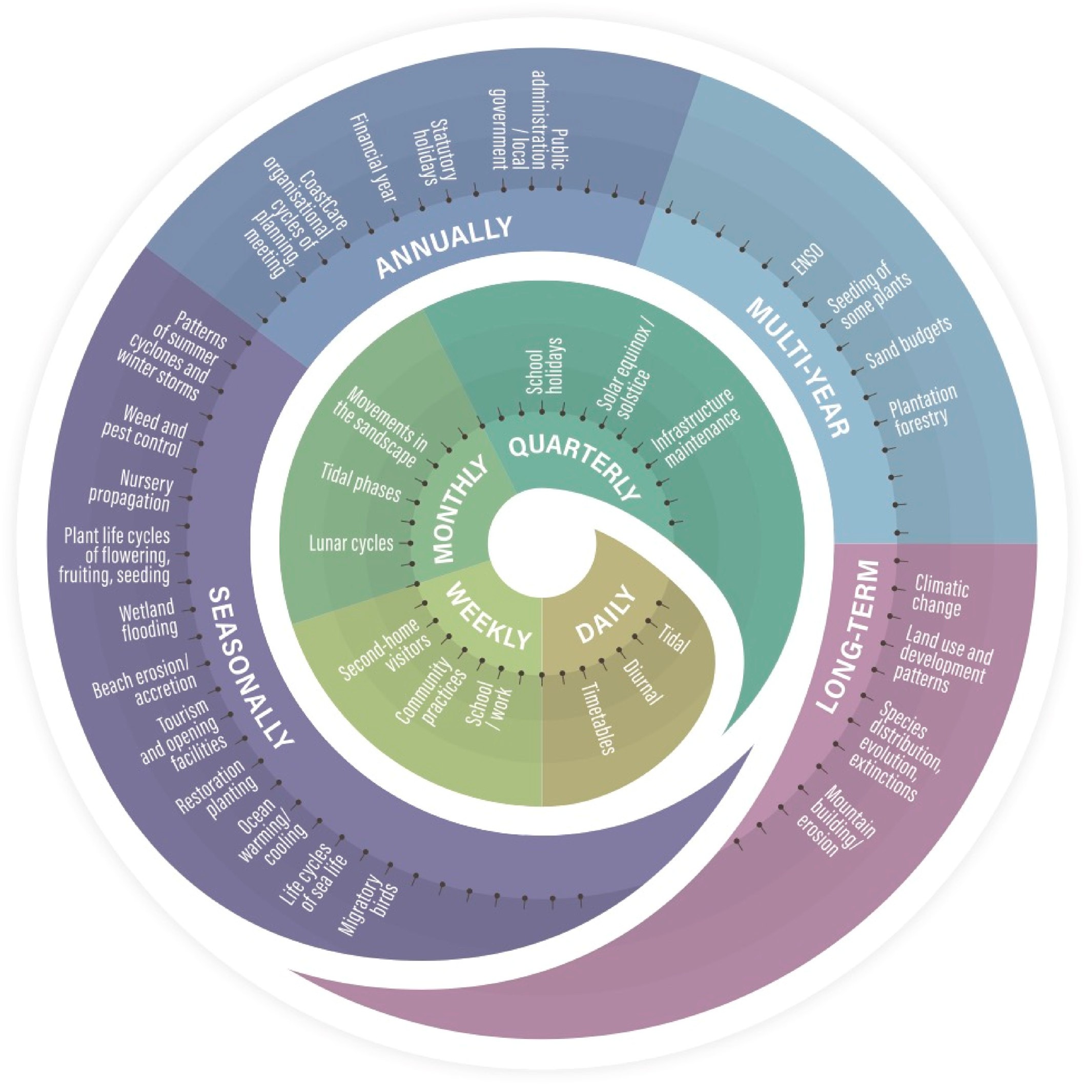
A visual representation of the layered polyrhythms associated with coastal flooding hazards, illustrated with examples from the Kūaotunu case study.
There are some existing studies, which seek to re-calibrate the timings of organisations to be more anticipatory of and resilient to risks, whether mapping the seasons when a municipality's water systems are under stress (Penn et al., 2016), re-timing the lighting of cold fires (small dispersed fires that burn at low temperatures) to shifting ecological cues (McKemey et al., 2020), or the calendars of institutions like universities (Bremer et al., 2023a). In the case of coastal conservation groups on the Kūaotunu Peninsula, it is the lived experience of practitioners that affords them unique temporal insights into their local environments. Consequently, it is as much about individuals and groups having the skills to ‘read’ the timings of hazard events, drawing on multiple temporal frameworks, from cultural calendars to seasonal forecasts, and the agility to marshal resources and social organisation for timely appropriate action. Disaster risk reduction and contingency planning overall can therefore benefit from considering composite seasonal (or poly-seasonal) rhythms in this context, by considering local hazardscapes as dynamic and polyrhythmic intersections of both social and environmental phenomena.
Footnotes
Acknowledgements
The authors want to thank the members of the Kuaotunu Coastcare groups that hosted KvZ and included her in all of their activities, and the wider CALENDARS project researcher community who have contributed to the enriching conversations from which some of these ideas have emerged. For this research, KvZ and SB received funding from the European Research Council (ERC) under the European Union's Horizon 2020 research and innovation program (Grant agreement 804150).
Declaration of conflicting interests
The authors declared no potential conflicts of interest with respect to the research, authorship, and/or publication of this article.
Funding
The authors disclosed receipt of the following financial support for the research, authorship, and/or publication of this article: This work was supported by the H2020 European Research Council, (grant number 804150).