
Abstract
Around the turn of the 20th century, the first state geologist at the Geological Survey of Norway, located in Kristiania (Oslo) at that time, Johan (also sometimes named John) Bernhard Rekstad established a series of marks, mostly crosses carved into boulders and bedrock slabs. These marks formed the basis for frontal measurements of outlet glaciers from Jostedalsbreen Ice Cap in western Norway. In total, he carved 29 marks in front of 15 outlet glaciers around the ice cap. For only a few of these marks, the exact locations have been known until recently. Therefore, the authors started a search for these marks some years ago, as they may provide valuable information on glacier frontal changes since their time of establishment. At present (2025), 18 marks in front of 12 different outlet glaciers from Jostedalsbreen Ice Cap have been rediscovered and documented by exact locations (coordinates and altitude) and photographs.
Keywords
Introduction
Glaciers are important visual indicators of climate change because they are sensitive to changes in precipitation during the accumulation season and temperature during the ablation season, manifested in annual changes in glacier mass balance and, with some years lag, frontal variations (advance, stillstand, or retreat; e.g. Hugonnet et al., 2021; IPCC, 2019; Lemke et al., 2007; Roe et al., 2017; Zemp et al., 2015).
Existing historical information, lichenometric dating of marginal moraines in the foreland of the Jostedalsbreen Ice Cap, and frontal changes of outlet glaciers descending from Jostedalsbreen Ice Cap demonstrate a significant glacier retreat from the “Little Ice Age” (LIA) glacier maximum extent during the mid-18th century (e.g. Andersen and Sollid, 1971; Andreassen, 2022; Andreassen et al., 2005, 2016, 2020, 2023; Andreassen and Winsvold, 2012; Bickerton and Matthews, 1992, 1993; Bohr, 1820; Carrivick et al., 2022; Eide, 1955; Erikstad and Sollid, 1986; Fægri, 1934; Foss, 1750 [1802]; Gjerde et al., 2023; Grove, 1988, 2004; Grove and Battagel, 1983; Hoel and Werenskiold, 1962; Imhof et al., 2012; Karijord, 1993; Mjanger and Hofsøy, 1989; Nesje, 1989, 1994, 2005, 2009; Nesje and Matthews, 2012, 2024; Nussbaumer et al., 2011; Rekstad, 1900, 1904, 1907; Winkler, 1996, 2021; Østrem et al., 1976). The largest outlet glaciers from Jostedalsbreen Ice Cap have lost >110 km2 (~19%) of their area during the mid-18th “Little Ice Age” maximum and approximately 14 km3 (18%) of their volume since the LIA maximum up to the recent years (Carrivick et al., 2022).
Reconstructions of the area of Jostedalsbreen Ice Cap show that during the LIA maximum extent (~1755), Jostedalsbreen Ice Cap covered around 572 km2, followed by a reduction of the glacier area to 500 km2 in 1966, 474 km2 in 2006, and 458 km2 in 2019 (Andreassen et al., 2023; Winsvold et al., 2014), and the outlet glaciers from Jostedalsbreen Ice Cap are expected to decrease significantly in the coming decades (Åkesson et al., 2025; Nesje, 2023). At present (mapping period 2018–2019), there are 5260 glaciers >0.01 km2 in mainland Norway. These glaciers cover an area of 2320 km2 (~0.7% of the mainland area; Andreassen, 2022), of which the 25 largest glaciers cover an area of 1466.1 km2.
In Norway, the first annual and systematic measurements of glacier-front variations were initiated around 1900 (1899 was the first year) at outlet glaciers at Jostedalsbreen and Folgefonna ice caps in western Norway, at valley glaciers in Jotunheimen mountain range in central southern Norway, and at Svartisen Ice Cap, Okstindbreen, and in Skjomen in northern Norway (nve.no). The frontal measurements were started by J.B. Rekstad (Bergen Museum), and A. Hoel and P.A. Øyen (University of Oslo). The measurements were continued by K. Fægri (Bergen Museum) and W. Werenskiold (University of Oslo). From 1948, O. Liestøl (Norwegian Polar Institute) took over responsibility for the frontal measurements. J.O. Hagen (Norwegian Polar Institute) continued the measurements 1985–1993. Since 1994, H. Elvehøy at The Hydrology Department of the Norwegian Water Resources and Energy Directorate (NVE) has been in charge of the glacier-front measurements in Norway. The measurements are reported annually to the World Glacier Monitoring Service in Zürich, Switzerland (https://wgms.ch/). The initial measurements were carried out by establishing marks by carving crosses and/or painting boulders and bedrock surfaces and commonly erecting a small cairn adjacent to the marks at a certain distance from the concurrent glacier fronts.
At present, the Norwegian Water Resources and Energy Directorate (NVE) is responsible for measuring, collecting, and storing data on glacier-front variations and glacier mass balance in mainland Norway (the data are freely available at: https://glacier.nve.no/Glacier/viewer/CI/no/). The present monitoring program of frontal change measurements at NVE includes 28 and 11 glaciers in southern and northern Norway, respectively. At present, the frontal measurements are carried out by measuring the distance from one or several (semi-fixed) points in predefined direction(s) by means of a laser meter or a tape measure at the end of the ablation season, commonly in late September/early October. How representative individual measurements are may be questioned; however, over longer (decadal scale) periods, the frontal measurements provide valuable data about glacier fluctuations and regional tendencies (Andreassen et al., 2020), including assessment of glacier dynamics and frontal time lags (e.g. Nesje, 2005; Nesje and Matthews, 2012). As the exact location of most of the marks established by Rekstad around Jostedalsbreen Ice Cap have been lost, the authors and a few others started a systematic survey to rediscover Rekstad’s marks.
Johan (John) Bernhard Rekstad (2 October 1852–1 April 1934) was born in Trondenes in Troms County, northern Norway. He acted as a schoolteacher at Røros, in Namsos, and at Lillehammer, and later as lecturer at Bergen katedralskole 1896–1900. In 1900 he was appointed as the first state geologist at the Geological Survey of Norway, then located in Kristiania (Oslo). He carried out numerous geological investigations in western Norway, in Jotunheimen mountain range and in Nordland, in addition to conducting glacier-front measurements, glaciological studies, and glacial geological investigations (Foslie, 1935). Rekstad published a large number of geological papers (see Foslie, 1935 for bibliography), and he was a keen nature photographer. His photograph collection consists of 2962 glass disks and negative films stored at Norwegian Geological Survey in Trondheim.
The purpose of this article is to document the marks that are presently unearthed. Around Jostedalsbreen Ice Cap, Rekstad established marks at altogether 15 outlet glaciers, of which marks at 12 of these outlet glaciers have thus far been rediscovered (Figure 1). Rekstad’s (1902, 1904) descriptions of the locations of the carved marks are rather short and restricted, so trying to rediscover them has been like searching for “the needle in the haystack.” The establishment of the historical marks is of great importance as a basis for quantitative reconstructions of glacier variations in recent centuries. There are, in fact, very few regions where such marks have enabled reconstruction of the spatial variation in glacier behavior before modern times. Norway, alongside the European Alps, is among the very few glacierized regions where such detailed measurements are available.
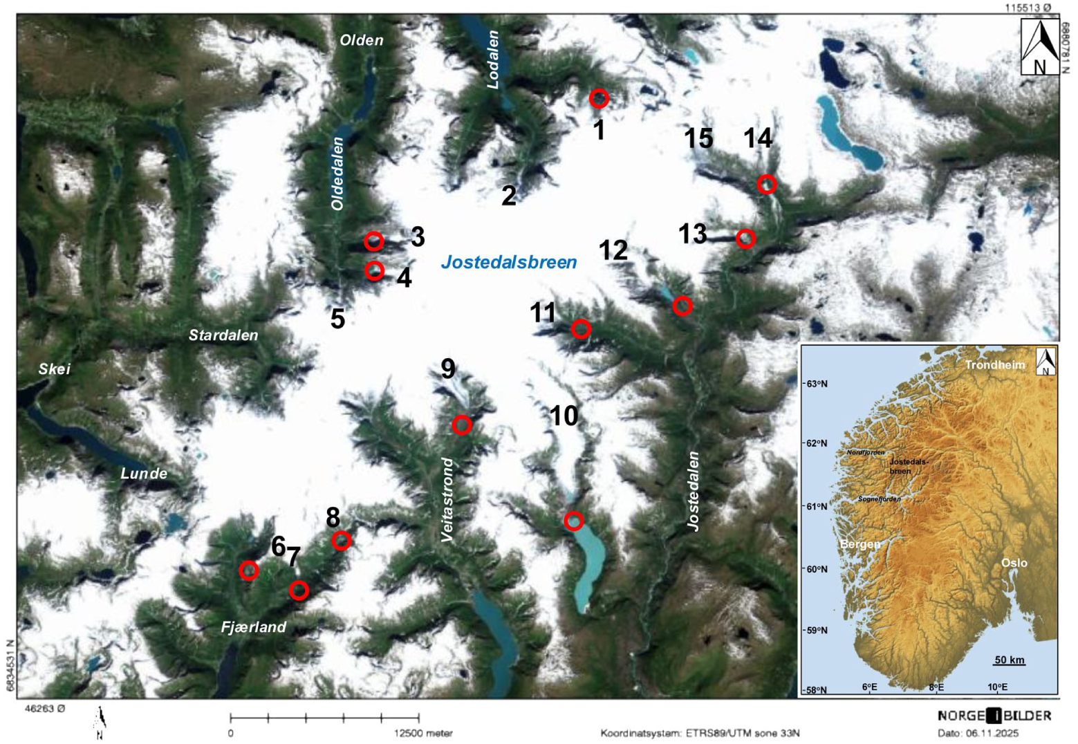
Location map of Jostedalsbreen Ice Cap with outlet glaciers where Johan Bernhard Rekstad established marks around the turn of the 20th century to measure glacier frontal changes (1–15). 1-Bødalsbreen, 2-Kjenndalsbreen, 3-Brenndalsbreen, 4-Briksdalsbreen, 5-Melkevollbreen, 6-Bøyabreen, 7-Supphellebreen, 8-Vetle Supphellebreen, 9-Austerdalsbreen, 10-Tunsbergdalsbreen, 11-Bergsetbreen, 12-Nigardsbreen, 13-Fåbergstølsbreen, 14-Stigaholtbreen, 15-Lodalsbreen. Red circles indicate outlet glaciers with rediscovered marks. Source: norgeibilder.no.
Johan Bernhard Rekstad’s marks established at outlet glaciers from Jostedalsbreen Ice Cap
Bødalsbreen in Lodalen
The “Little Ice Age” glacier foreland of Bødalsbreen consists of some prominent moraines, of which the saw-toothed moraines, dated at ~1767, 1820, and 1897 (Bickerton and Matthews, 1993), are the most spectacular (Figures 1 and S1). In a photograph by Rekstad, dated to 19 September 1900 (likely the date when he established the mark), the boulder where he presumably established the mark (red painting on a big boulder on the eastern side of the glacier meltwater stream from Sætrevatnet, with a cairn on top of the boulder) is visible (Figures 1 and 2). Figure S2A shows Bødalsbreen in 1900. Based on a visit to the glacier foreland on 11 July 2019, and based on Rekstad’s photograph from September 1900 and two photographs by K. Knudsen from 1900, it was possible to identify the boulder were Rekstad painted the mark (the red painting was no longer visible and the stones in the cairn on top of the boulders have fallen down; coordinates: 61°47′53.64259″N/7°6′8.88861″E, altitude: 608 m a.s.l.; Table 1).
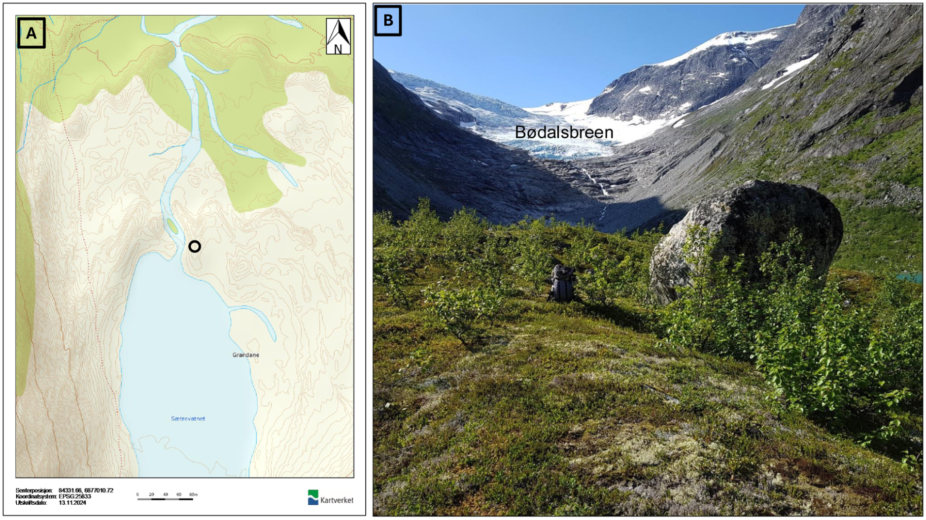
(a) The location of the boulder (b) where the red cross was established for measuring the glacier front variations of Bødalsbreen (circle). Map source: norgeskart.no. Photographer: Atle Nesje on 11 July 2019.
The outlet glaciers from Jostedalsbreen Ice Cap where Johan Bernhard Rekstad’s boulders/marks have been rediscovered and documented.
Mark not rediscovered.
Kjenndalsbreen in Lodalen
In 1900, Rekstad established a mark, a cross carved into a vertical bedrock cliff on the eastern side of the glacier meltwater stream from Kjenndalsbreen (Figures 1 and S2B), at a distance of 30.2 m from the glacier front. This mark has not yet been rediscovered.
Brenndalsbreen (previously named Aabrekkebreen) in Oldedalen
The “Little Ice Age” glacier foreland of Brenndalsbreen (Figures 1 and S2C) consists of number of marginal moraines deposited during the general retreat subsequent to the “Little Ice Age” maximum around the mid-18th century (Engen et al., 2024; Nesje, 1994). Due to dense vegetation, the moraines are hardly visible; however, they are easily recognizable on LiDAR images (Figure S3). In 1900, Rekstad carved two marks (crosses); one mark into a boulder at the southern riverbank of the glacier meltwater stream (Brenna) from Brenndalsbreen at a distance of 55.75 m from the glacier front, and a second mark into a vertical rock face on the southern side of the glacier meltwater stream, at a distance of 53 m from the glacier front. A. Nesje and the late farmer Rasmus Aabrekk from the adjacent farm visited the glacier foreland in December 1993, and after some search they spotted the latter mark (coordinates: 61°40′51.47841″N/6°50′17.58632″E, altitude: 265 m a.s.l.; Table 1 and Figure 3a–c).
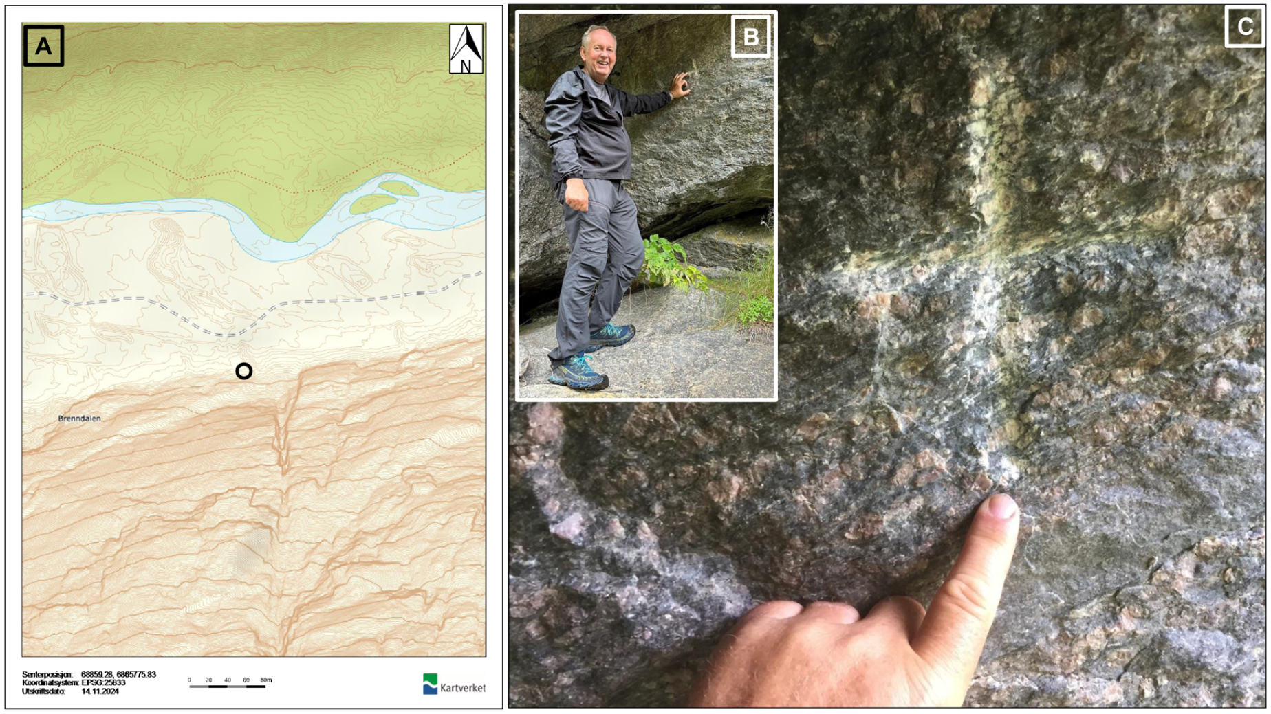
(a) The location of the rediscovered mark (circle); a cross carved into a vertical bedrock cliff (b). Photo (c) is a close-up of the cross. Map source: norgeskart.no. Photographer (b): Siri Hatlen 2023. Photographer (c): Atle Nesje 2021.
Briksdalsbreen in Oldedalen
In 1900, Rekstad established two marks in the glacier foreland of Briksdalsbreen (Figures 1 and S2D), one cross carved into the bedrock surface on the southern side of the glacier meltwater stream from Briksdalsbreen at a distance of 26.25 m from the glacier front, and a second cross carved into a boulder on the northern side of the glacier meltwater stream, at a distance of 30.28 m from the glacier front. A photograph of Briksdalsbreen dated 14 September 1900 most likely indicates the date when Rekstad established the marks. Despite extensive searches, the mark on the southern side of the meltwater stream has not been rediscovered. However, on 18 October 2018 the cross carved into the boulder on the northern side of the meltwater stream was rediscovered (Table 1 and Figure 4a–c; coordinates: 61°39′54.70809″N/6°50′58.75114″E, altitude: 327 m a.s.l.). Between 1900 and 1904, the front of Briksdalsbreen retreated 26 m, which contrasts with the period between 1904 and 1910 when the glacier front advanced 73 m. As a consequence, the boulder with the cross was pushed 16 m (and rotated horizontally as observed on later photographs by Rekstad) between 1908 and 1910.
(a) The location of the perched boulder in the glacier foreland of Briksdalsbreen. (b, c) The cross carved into the boulder in the glacier foreland of Briksdalsbreen. Map source: norgeskart.no. Photographer (b) and (c): Atle Nesje on 18 October 2018.
Melkevollbreen in Oldedalen
On 15th of September 1900, Rekstad established a cross carved into a vertical bedrock cliff on the eastern side of the glacier meltwater stream from Melkevollbreen (Figures 1 and S4A), at a distance of 67.26 m from the glacier front. Between 1900 and 1904, the glacier front retreated 61 m, and during a subsequent glacier advance that lasted until 1911, the glacier front advanced 177 m, reaching a frontal position 49 m beyond the mark (data: https://glacier.nve.no/Glacier/viewer/CI/no/). This mark has therefore most likely been destroyed by subglacial erosion. As far as we know, this mark has not been searched for during recent years because the foot path through the narrow valley gorge in the glacier foreland has been, and still is, subject to rockfall activity, and searches for the mark are therefore hazardous.
Bøyabreen in Fjærland
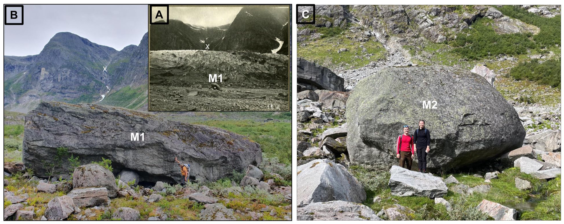
The “Little Ice Age” glacier foreland of Bøyabreen (Figure S4B) consists of some well-developed marginal moraines, of which the most prominent ones have been dated lichenometrically and historically (Figure S5; Aa and Sjåstad, 2000). Rekstad’s mark 1 (M1) was a cross and year “1899” carved into a boulder on the NW side of a big boulder on the western side of the meltwater stream from Bøyabreen on the first terminal moraine beyond the glacier front, at a distance of 65 m from the terminus (Table 1). Figure 5a displays a photograph taken from M2 on the northern side of the valley by Rekstad (Rekstad, 1904), showing the boulder (encircled) marked by a cross (mark 1 (M1)). The line-of-sight from M2 to M1 is indicated by the black arrow, also displayed in Figure 6b. Figure 5c and d show apparently the boulder hosing M1 (coordinates: 61°29′1.95435″N/6°44′59.38961″E, altitude: 152 m a.s.l.). The mark (cross and the year “1899”) has, however, not been spotted on the boulder because the boulder apparently was rotated or tumbled around by Bøyabreen during an advance of 138 m between 1904 and 1909 (data: https://glacier.nve.no/Glacier/viewer/CI/no/). The boulder with M1, previously partly hidden among trees, was exposed after a wet snow avalanche in March 2025 (Figure 5d).
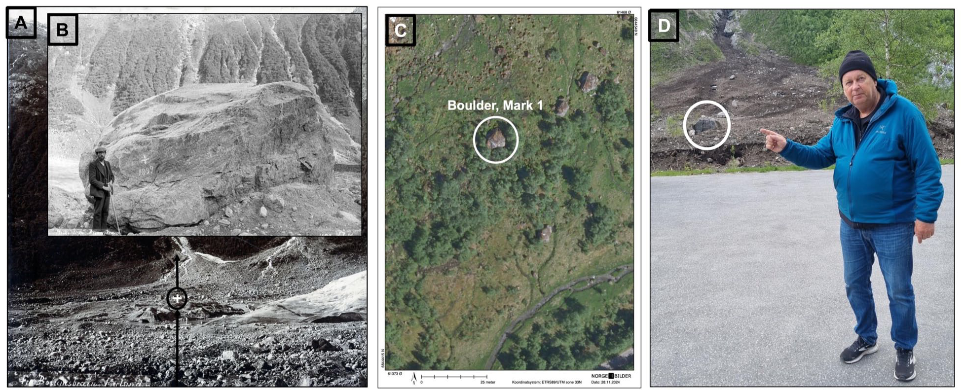
(a) Photograph taken by Johan Bernhard Rekstad on 30 August 1899 from mark 2 (M2) on the northern side of the valley showing the boulder (encircled and marked by a white cross (mark 1 (M1); Rekstad, 1904). The black arrow indicates the line-in sight from M2 to M1. (b) The boulder with M1 (cross) and year 1899. The person adjacent to the boulder is the local mountaineer Mikkel Mundal (1857–1932). Photographer: Johan Bernhard Rekstad. (c) The most likely boulder hosting M1 (photo C: norgeibilder.no). (d) The boulder with M1 was exposed after a wet snow avalanche in March 2025 (photographer: Liss Marie Andreassen May 2025).
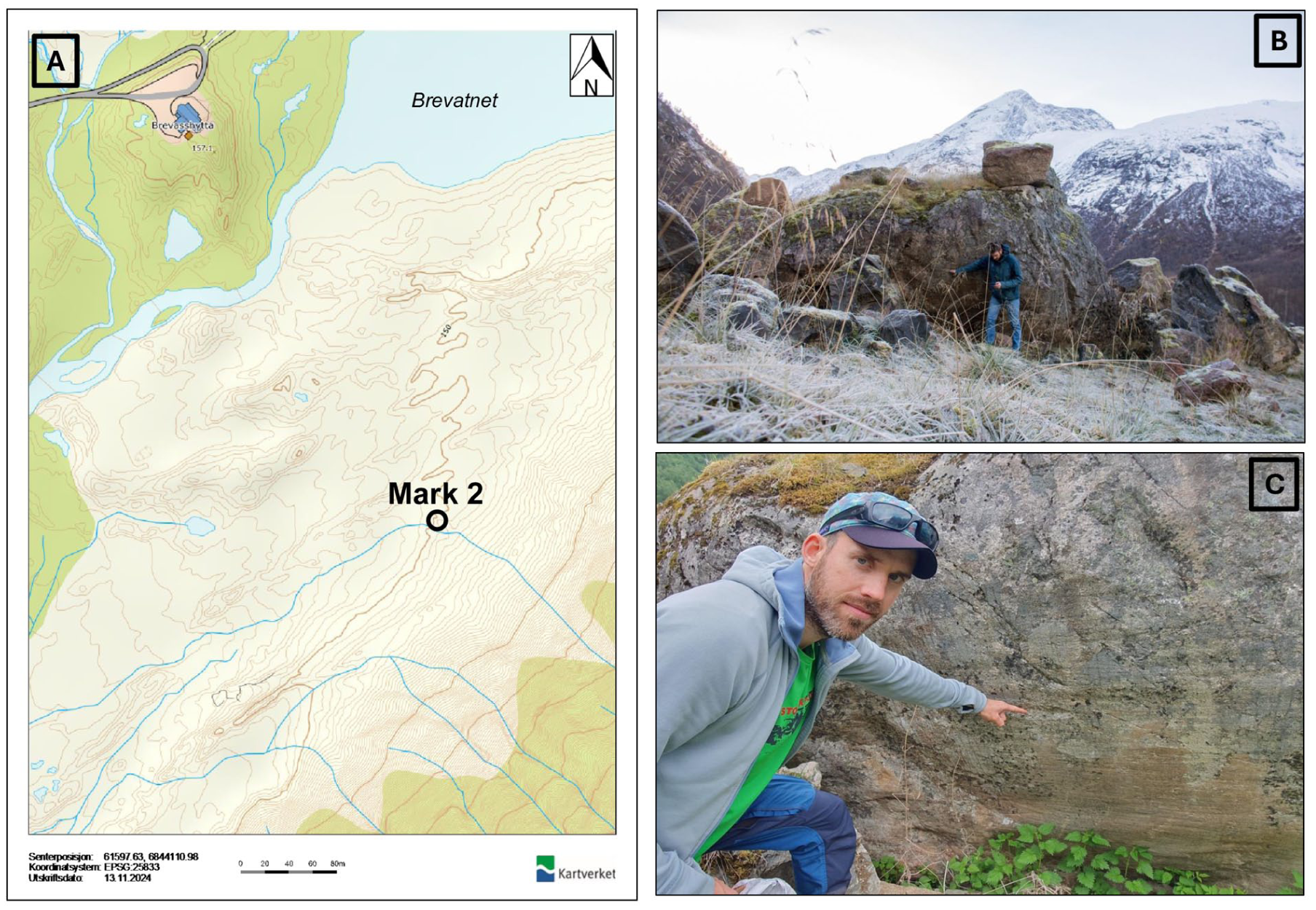
(a) The location of mark 2 (M2); a cross carved into a boulder in the glacier foreland of Bøyabreen (b and c). Map source: norgeskart.no. Photographer (b): Svein Arne Bøyum on 10 November 2013. Photographer (c): Atle Nesje on 2 June 2024.
Mark 2 (M2) was established by Rekstad in 1899 as a cross carved into a boulder on the eastern side of the meltwater stream, at a distance of 255 m from the front of Bøyabreen. From a student thesis at the Regional College in Sogndal, it is obvious that Mjanger and Hofsøy (1989) rediscovered the boulder with mark M2. On 10 November 2023, P.H. Kielland also discovered this mark located on the side of the boulder facing the front of Bøyabreen (Table 1 and Figure 6a–c; coordinates: 61°28′48.14386″N/6°45′22.53512″E, altitude: 151 m a.s.l).
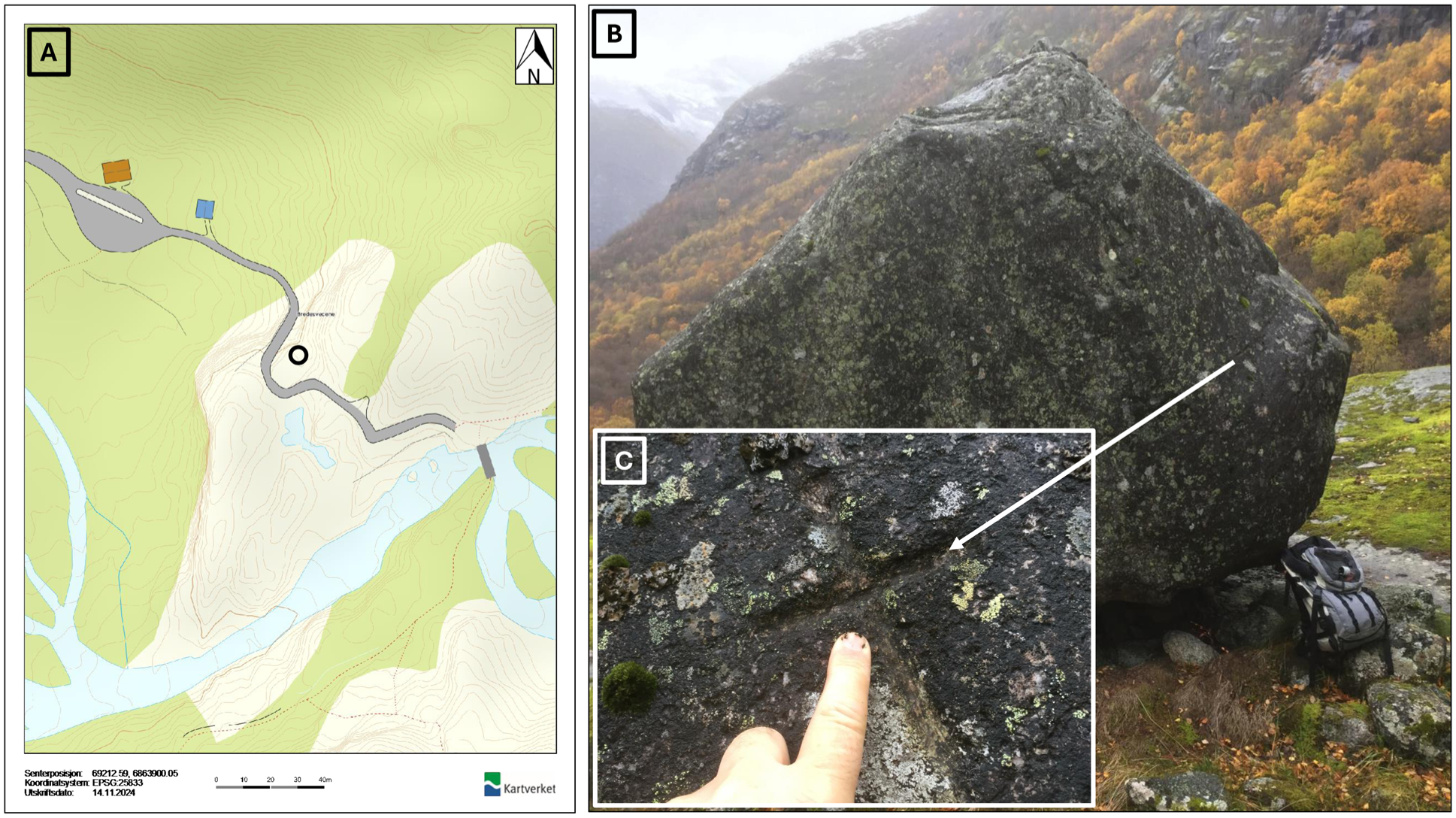
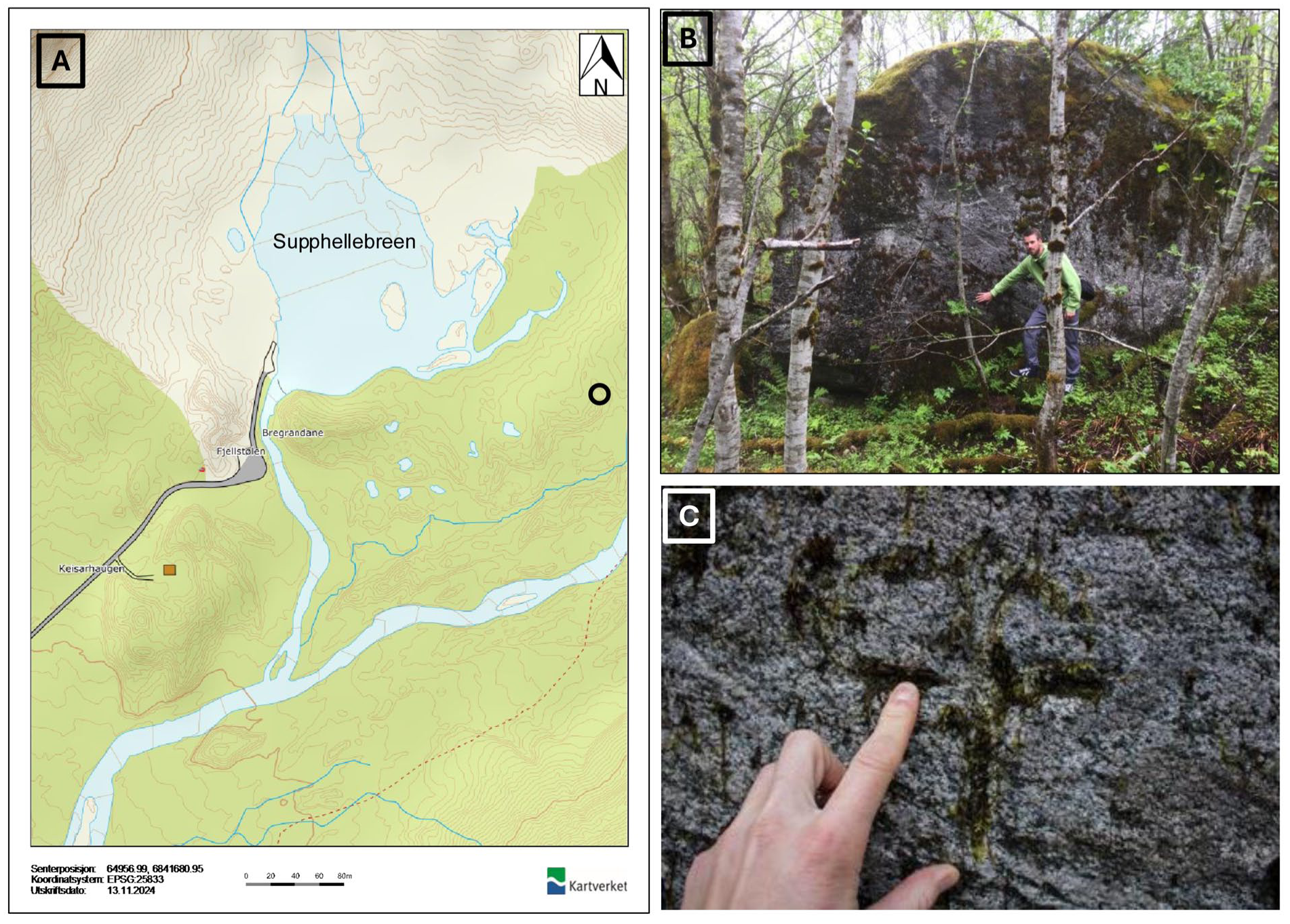
Supphellebreen in Fjærland
The “Little Ice Age” glacier foreland of Supphellebreen (Figures 1 and S4C) consists of some prominent marginal moraines dated by Karijord (1993; Figure S6). In 1899, Rekstad established three marks at Supphellebreen. The first mark (M1) was a cross carved into bedrock on the northwestern side of the glacier, with a cairn next to the mark, at a distance of 135.5 m from the glacier front. Based on Rekstad’s (1902) description of the mark and photographs by Rekstad in 1906 and 1908, the approximate location of the mark is indicated in Figure S6. This mark has not yet been rediscovered.
The second mark (M2) was a cross carved into the northern side of a boulder located on the second moraine in the middle part of the glacier front at a distance of 77.5 m from Supphellebreen. Mark M2 was rediscovered on 25 October 2016 (Table 1 and Figures 7 and S6; coordinates M2: 61°27′48.10522″N/6°49′34.67325″E, altitude: 67 m a.s.l.).
(a) The location of the boulder (b) with a cross carved into the boulder (c) in the glacier foreland of Supphellebreen. Map source: norgeskart.no. Photographer (b): Atle Nesje 2017. Photographer (c): Pål Hage Kielland on 25 October 2016.
The third mark (M3) was a cross carved into a boulder on the third moraine on the southwestern side of the glacier, with a cairn next to it. The distance to the glacier front was at the time 178.5 m. Based on Rekstad’s (1902) description of the mark and photographs by Rekstad from 1906 and 1908, the approximate location of mark M3 is indicated in Figure S6. Despite extensive search, this mark has not yet been rediscovered.
Vetle Supphellebreen in Fjærland
In the glacier foreland of Vetle Supphellebreen (Figures 1 and S4D), Rekstad established two marks in 1899. The first mark was a cross carved into bedrock in front of the glacier, at a distance of 62.5 m from the front. This mark has not yet been rediscovered.
The second mark was a cross carved into a boulder next to the glacier meltwater stream from Vetle Supphellebreen, at a distance of 19.24 m from the front. The second mark was rediscovered on 11 October 2018 (Table 1 and Figure 8a–c; coordinates: 61°29′42.11303″N/6°52′5.05578″E, altitude: 418 m a.s.l.).
(a) The location of the boulder (b) with a cross carved into the boulder (c) in the glacier foreland of Vetle Supphellebreen. Map source: norgeskart.no. Photographer (b) and (c): Pål Hage Kielland on 11 October 2018.
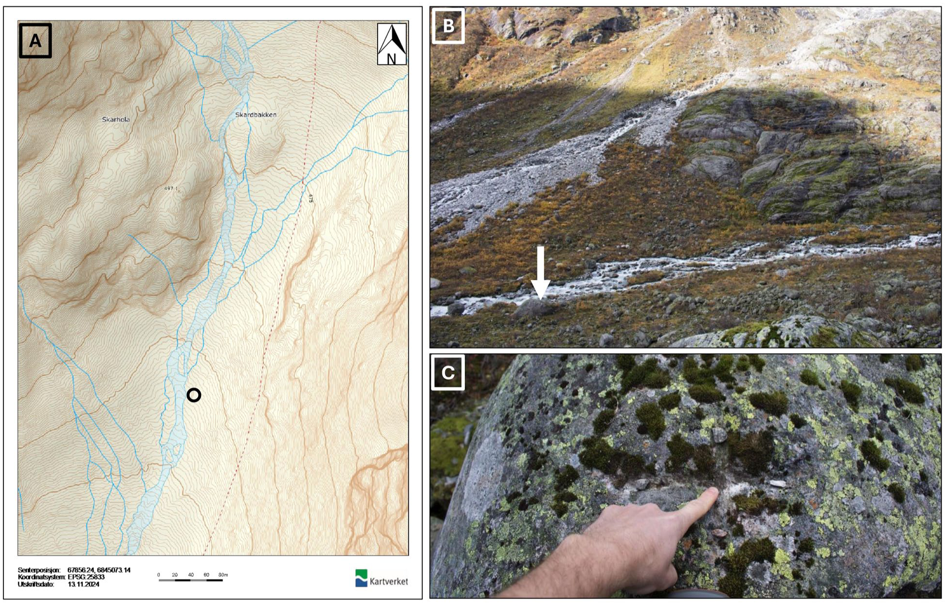
Austerdalsbreen in Veitastrond
The “Little Ice Age” glacier foreland of Austerdalsbreen consists of some prominent marginal moraines dated by Bickerton and Matthews (1993; Figure S7). At Austerdalsbreen (Figures 1 and S8A), Rekstad established two marks in late August 1905. The first mark (M1) was a cross carved into a dark part on the southern side of an erratic boulder located on the western side of the meltwater stream from Austerdalsbreen (white “+” on Figure 9a, coordinates: 61°34′27.19634″N/6°59′22.74338″E, altitude 347 m a.s.l.). A small cairn was erected on top of a stone next to the boulder, and this cairn is visible on the photograph (Figure 9b). On 31 August 1905, the distance to the glacier front was 74 m. Measurements of the glacier front positions show that the glacier front advanced 63 m between 1905 and 1909 (data: https://glacier.nve.no/Glacier/viewer/CI/no/). The site was visited on 31 July 2025, and it was observed that the 1909 moraine was ~20 m beyond the boulder. In addition, the long axis of the boulder had been reoriented 76° from the original long-axis orientation of 210° before the 1905–1909 advance, to its post-1909 long-axis orientation of 286° (Figure S9A and B).
(a) Photograph of mark M1 in the glacier foreland of Austerdalsbreen. White “+” marks the position of M1. Photographer: Johan Bernhard Rekstad. (b) The M1 boulder at present shows that the boulder was reoriented and rotated during a glacier readvance 1905–1909. Photographer: Atle Nesje. (c) The mark M2 boulder. Photographer: Jacob C. Yde on 21 August 2025.
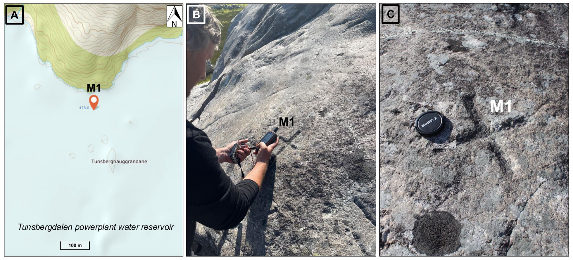
(a) The positions of mark M1 established by Johan Bernhard Rekstad in 1900 in the glacier foreland of Tunsbergdalsbreen (map source: norgeskart.no). When the water level in the hydroelectric power reservoir is at its maximum (478 m a.s.l.), the mark is under water. The mark is usually visible in the spring and early summer when the water level in the reservoir is lowered. (b and c) M1 was rediscovered on 25 June 2025. Photographer (c) and (d): Marthe Gjerde.
The second mark (M2) was carved into the eastern side of a glacially sculptured, striated erratic boulder, and the distance between M1 and M2 was 111.5 m. An erratic boulder that fits the description by Rekstad of M2 was observed among numerous “fresh” angular avalanche boulders, but a mark was not visible (Figure 9c; coordinates M2: 61°31′24.78635″N/6°59′17.62405″E, altitude: 349 m a.s.l.).
Tunsbergdalsbreen in Jostedalen
In the glacier foreland of Tunsbergdalsbreen (Figures 1, 10A, and S8B), the longest outlet glacier from Jostedalsbreen Ice Cap, Rekstad established two marks in 1900 (Figure 10B). The first cross was carved into a southward-sloping bedrock slab on the eastern side of the glacier meltwater stream from Tunsbergdalsbreen, at a distance of 102 m from the glacier front in 1900. This cross (M1) was rediscovered on 25 June 2025 (Figure 10C and D; co-ordinates: 61°31′11.8092″E/7°9′2.1276″E, altitude: 472 m a.s.l).
The second cross (M2) was carved into a bedrock surface on the western side of the meltwater stream from Tunsbergdalsbreen and close to the southern side of Tverrdalselvi river. The distance from this mark to the glacier front was not stated. This mark (M2) has not been rediscovered, but a small cairn was spotted during a visit in June 2025 at the approximate position of the mark.
Bergsetbreen in Jostedalen
The “Little Ice Age” foreland of Bergsetbreen (Figures 1 and S8C) contains some well-developed marginal moraines and some of the most prominent have been dated lichenometrically (Bickerton and Matthews, 1993). In 1899, Rekstad established two marks in the glacier foreland.
A cross with the year “1899” was carved into the northwestern side of a boulder on the northern side of the meltwater stream from Bergsetbreen, with a cairn on top of the boulder (M1: coordinates: 61°38′49.2828″N/7°7′3.6084″E, altitude: 443 m a.s.l.). The distance to the glacier front was noticed to be 183.5 m. This mark was rediscovered in 2025 (Figure 11a–d).
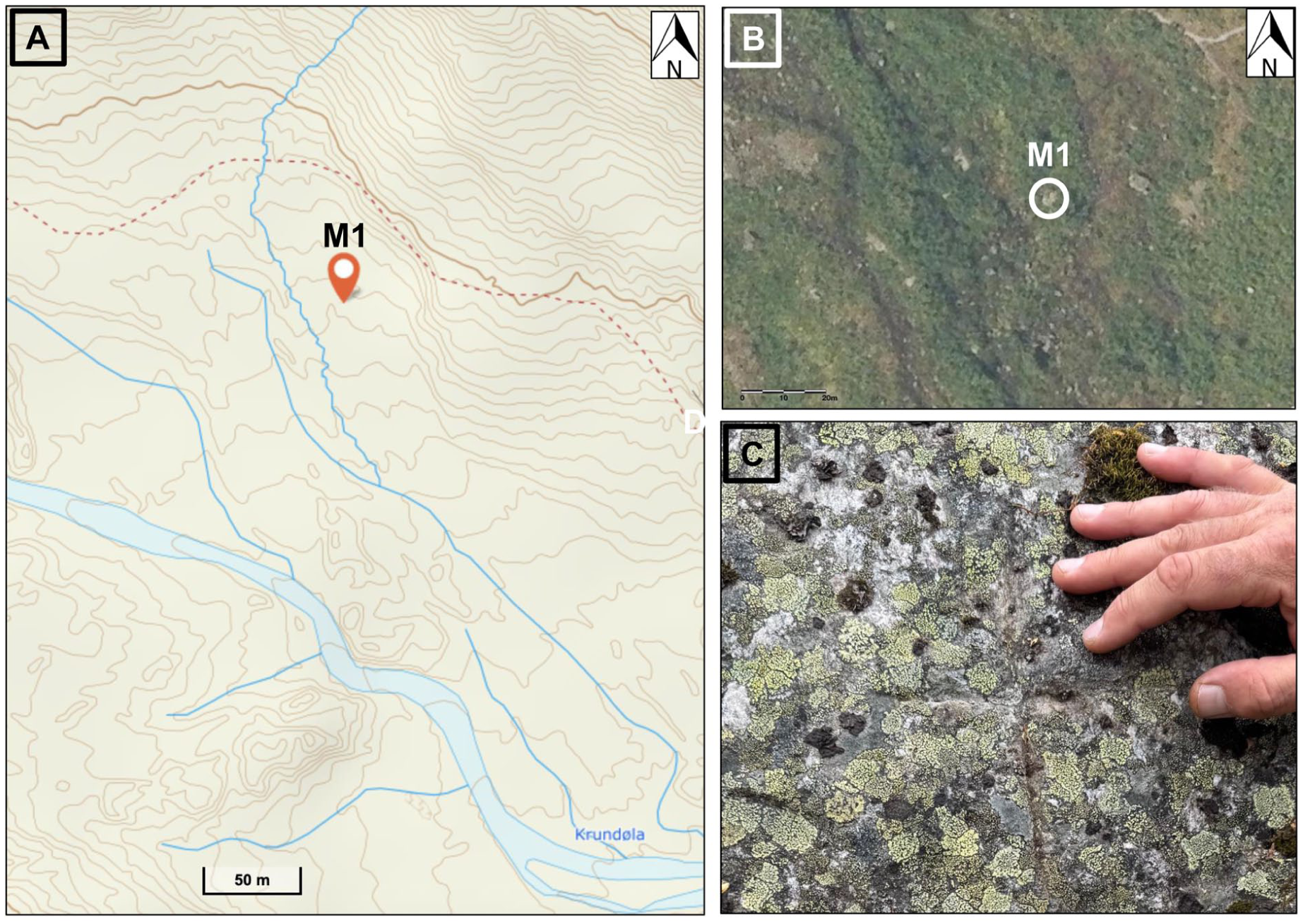
(a) The location and coordinates of the boulder with a cross (M1) carved into the boulder (b and c) in the glacier foreland of Bergsetbreen. (c) Map source: norgeibilder.no. Photographer (c): Jostein Aasen.
The other mark (M2; carved cross), rediscovered in 2025, was established on the northern side of a big boulder on the southern side of the meltwater stream from Bergsetbreen (Figure 12a–c), at a distance of 210.5 m (M2: coordinates: 61°38′38.10684″N/7°6′57.90328″E, altitude: 452 m a.s.l.).
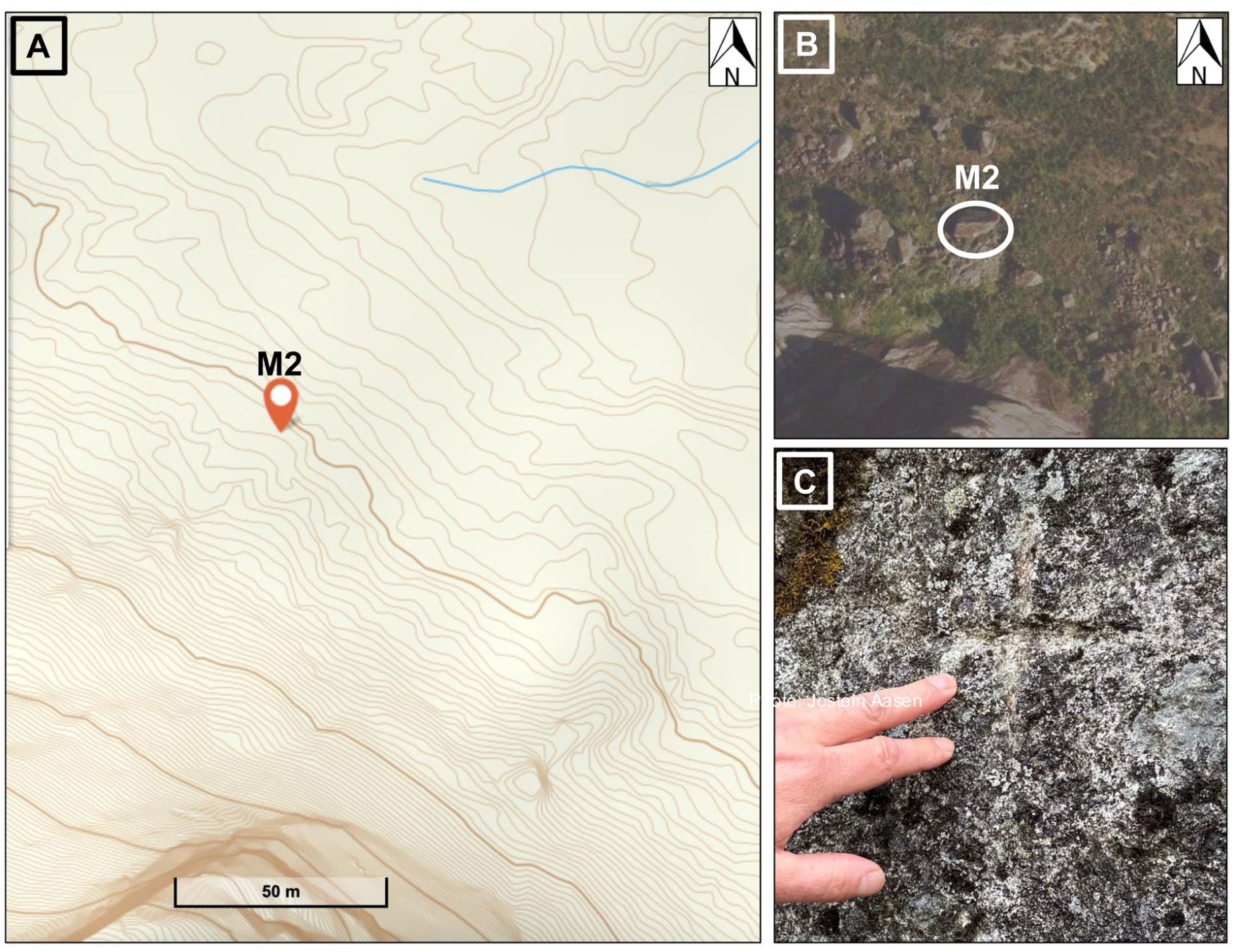
(a) The location and coordinates of the boulder with a cross (M2) carved into the boulder (b and c) in the glacier foreland of Bergsetbreen. (c) Map source: norgeibilder.no. Photographer (c): Jostein Aasen.
Nigardsbreen in Jostedalen
The “Little Ice Age” foreland of Nigardsbreen (Figures 1 and S8D) consists of an extensively studied and well-dated sequence of marginal moraines (Figure S10). In 1899, Rekstad established three marks (Rekstad, 1902).
The first mark (M1) was a cross with the year “1899” carved into a rock slab on the NE side of the meltwater stream from Nigardsbreen, 344 m from the glacier front (Figure 13a and b). Mark M1 was rediscovered by on 11 November 2018 (Table 1; coordinates: 61°40′2.1537″N/7°15′11.69864″E, altitude: 334 m a.s.l.).
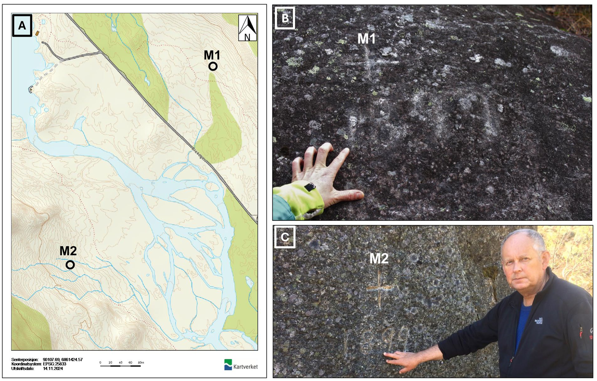
(a) The location of the marks M1 and M2 in the glacier foreland of Nigardsbreen (map source: norgeskart.no). (b) M1: Cross and the year “1899” carved into a bedrock slab (photo: Marthe Gjerde in November 2020). (c) M2: Boulder with a cross and the year “1899” carved into the northern side of the boulder. Photographer: Svein Olaf Dahl on 23 May 2018.
The second mark (M2) was a cross with the year “1899” carved into the northern side of a big boulder on the southwestern side of the meltwater stream from Nigardsbreen (Figure 13a and c). A distance of 113 m to the glacier front was noticed. M2 was rediscovered on 23 May 2017 (Table 1; coordinates: 61°39′51.23169″N/7°14′37.66178″E, altitude: 290 m a.s.l.).
The third mark (M3) was a cross carved into a big boulder higher up in the terrain than the second mark, at a distance of 209 m from the second mark (M2). Some years ago, a rockfall hit the area where the boulder with mark M3 was located. It is therefore unlikely that this mark can be rediscovered.
Fåbergstølsbreen in Jostedalen
The foreland of Fåbergstølsbreen (Figures 1 and S11A) consists of a lichenometrically-dated moraine sequence (Bickerton and Matthews, 1993; Figure S12). In 1899, Rekstad established two marks in the glacier foreland (Rekstad, 1902).
The first mark (M1) was a cross carved into a bedrock surface, with a cairn nearby, on the southern side of the meltwater stream from Fåbergstølsbreen. M1 was rediscovered on 30 May 2019, (Table 1 and Figure 14a and b; coordinates M1: 61°42′26.96415″N/7°19′34.166″E, altitude M1:524 m a.s.l.).
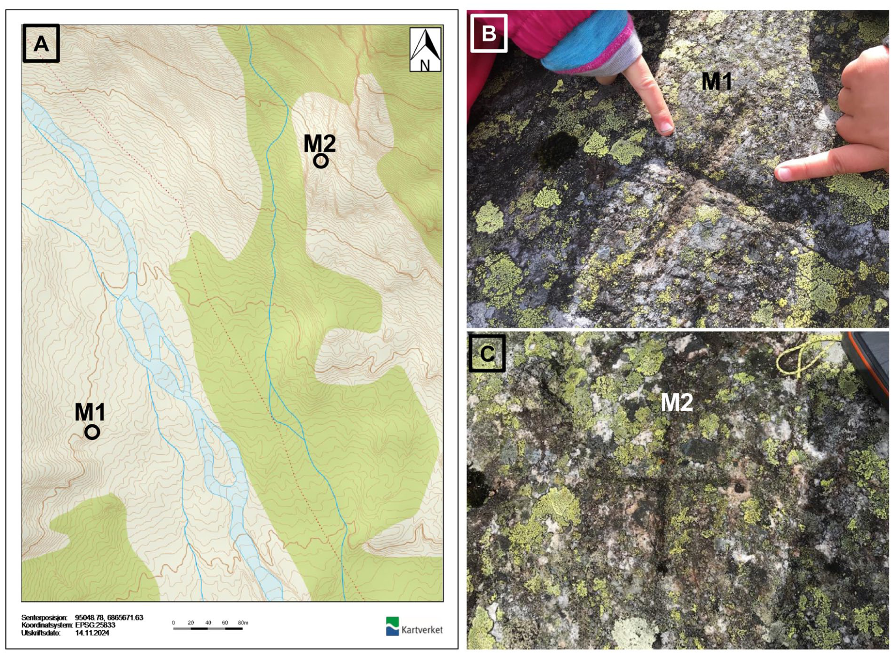
(a) The location of the marks M1 and M2 in the glacier foreland of Fåbergstølsbreen (map source: norgeskart.no). (b) M1: Cross carved into a bedrock slab (photographer: Jostein Aasen on 30 May 2019). (c) M2: Boulder with a cross carved into a bedrock slab (photographer: Jostein Aasen on 31 May 2019).
The second mark (M2) was a cross carved into a bedrock nob on the northern side of the meltwater stream from Fåbergstølsbreen. M1 and M2 were rediscovered on 31 May 2019 (Table 1 and Figure 14a and c; coordinates M1: 61°42′26.96415″N/7°19′34.166″E, altitude M1: 524 m; coordinates M2: 61°42′37.97216″N/7°19′49.38559″E, altitude M2: 575 m a.s.l.).
Stigaholtbreen in Jostedalen
At Stigaholtbreen (Figures 1 and S11B), Rekstad established two marks in 1903 (Rekstad, 1904). Mark M1 was a cross carved into the southern side of a perched boulder. A small cairn was erected on top of the boulder. M1 was rediscovered on 3 October 2018 (Table 1 and Figure 15a–c; coordinates mark M1: 61°45′7.16059″N/7°19′53.1524″E, altitude M1: 637 m a.s.l.).
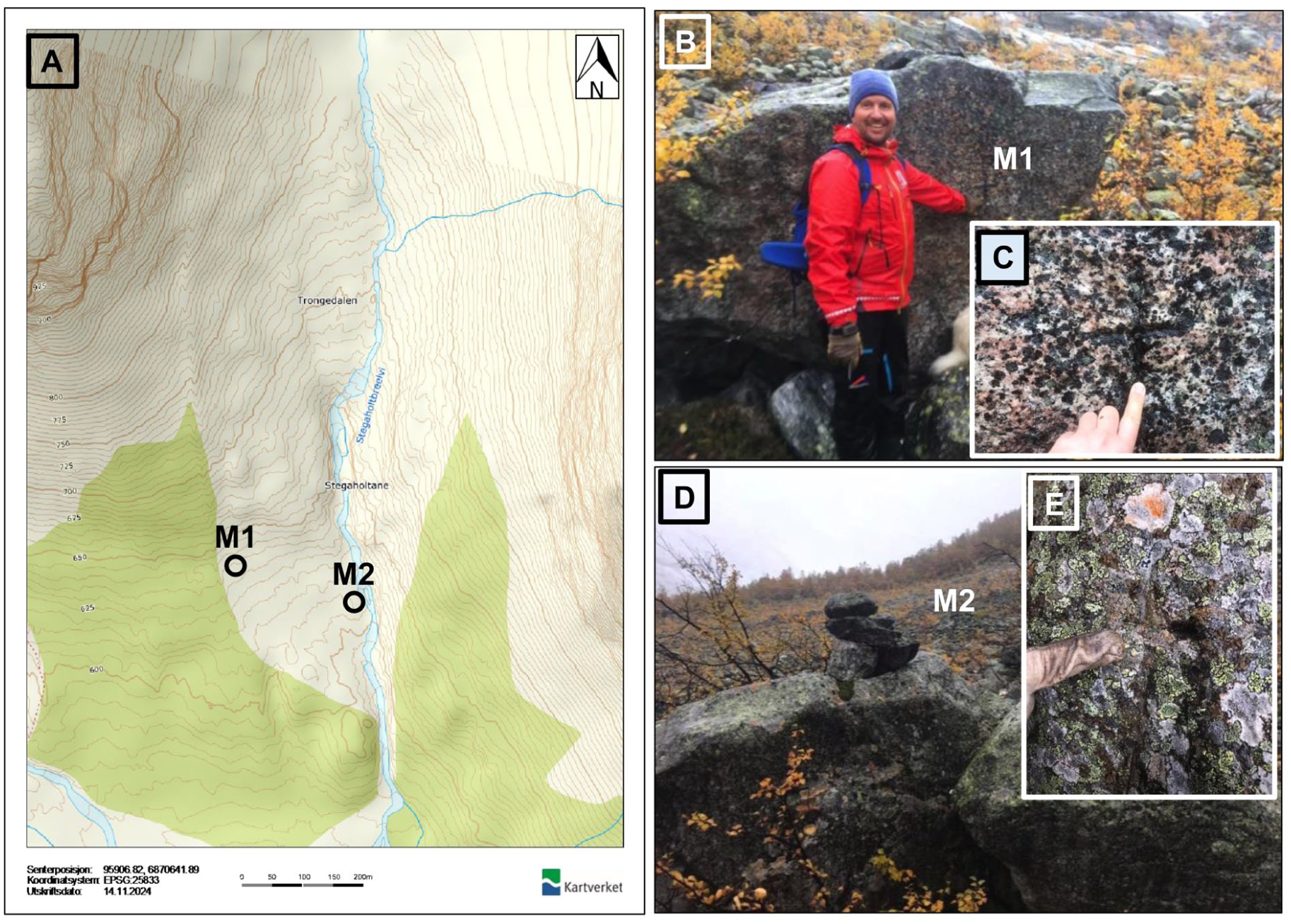
(a) The location of the marks M1 and M2 in the glacier foreland of Stigaholtbreen (map source: norgeskart.no). (b and c) mark M1: Cross carved into a perched boulder (photographer: Even Loe on 3 October 2018). (d and e) mark M2: Boulder with a cross carved into a perched boulder, with a cairn erected on top of a boulder. Photographer: Even Loe on 3 October 2018).
Mark M2 was a cross carved into bedrock nob close to the meltwater stream from Stigaholtbreen, with a small cairn adjacent to the mark. Mark M2 was rediscovered on 3 October 2018 (Table 1 and Figure 15a, d, and e; coordinates mark M2: 61°45′6.13059″N/7°20′7.87208″E, altitude M2: 613 m a.s.l.).
Lodalsbreen in Jostedalen
In the glacier foreland of Lodalsbreen (Figures 1 and S11C), Rekstad established two marks in 1899 (Rekstad, 1902). One of them was a cross with the year “1899” carved into a bedrock nob on the northern side of the meltwater stream from Lodalsbreen, with a small cairn erected next to the mark. Rekstad (1902) recorded a distance of 69 m to the glacier front for this mark.
The other mark was a cross carved into a bedrock nob on the southern side of the glacier meltwater stream, at a distance of 26 m to the glacier front. A small cairn was erected next to the mark. Despite extensive searches, the marks in the foreland of Lodalsbreen have not yet been rediscovered.
Cumulative glacier-front variations from the establishment of the marks until present
Figure 16 shows cumulative variations of the individual outlet glaciers from the Jostedalsbreen Ice Cap as Rekstad established marks around the turn of the 20th century; the measurement period(s) of the individual glaciers are shown in Table 2. Due to different circumstances, there are several gaps in the measurement periods of glacier frontal changes. The general pattern of the glacier variations during the 20th century is that the outlet glaciers from the Jostedalsbreen Ice Cap experienced relatively short-lived (decadal) advances in the first part of the 20th century followed by a significant retreat during the mid-20th century until the more recent advance (the Briksdalsbre Event; Nesje and Matthews, 2012) in the 1990s (Nesje, 1989, 2005; Winkler, 1996). The glacier advances during the first half of the 20th century were caused by lower summer temperatures than the long-term average, whereas the significant frontal retreat during the mid-20th century was caused by a combined effect of less winter precipitation and higher summer temperatures than the long-term averages. The glacial advances during the Briksdalsbre Event, on the other hand, was exclusively a result of high winter precipitation (positive North Atlantic Oscillation Index; e.g. Nesje, 2005; Nesje and Matthews, 2012). The frontal retreat of the outlet glaciers from the Jostedalsbreen Ice Cap during the first decades of the 21st century was mainly due to above normal summer temperatures (Andreassen et al., 2020, 2023).
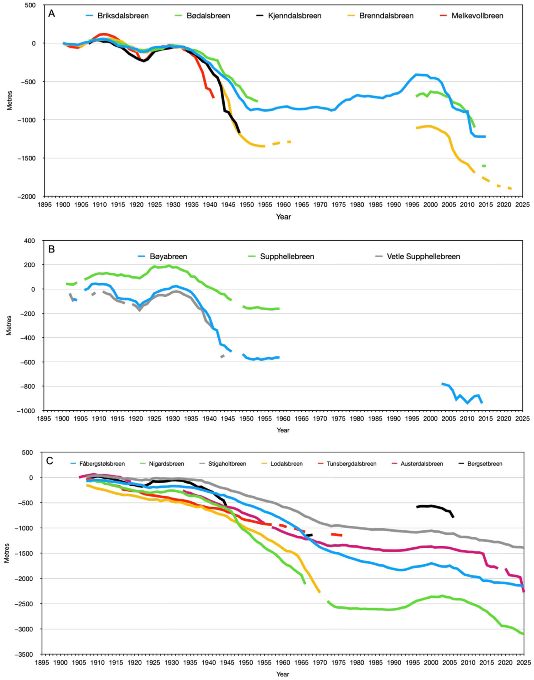
Cumulative variations of the outlet glaciers from Jostedalsbreen Ice Cap that Johan Bernhard Rekstad established marks around the turn of the 20th century. (a) Outlet glaciers at the western side of the ice cap (Lodalen and Oldedalen). (b) Outlet glaciers at the southern side (Fjærland). (c) Outlet glacier on the eastern side (Veitastrond and Jostedalen). Data and graphs are available at https://glacier.nve.no/Glacier/viewer/CI/no/.
Frontal measurement period(s) of the individual outlet glaciers from Jostedalsbreen Ice Cap that Johan Bernhard Rekstad established marks around the turn of the 20th century (https://glacier.nve.no/Glacier/viewer/CI/no/).
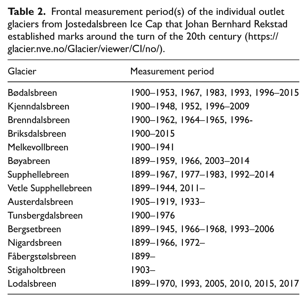
Figure 16 also illustrates differences in frontal time lag of the outlet glaciers from the Jostedalsbreen Ice Cap. The general pattern is that the frontal time lag is shorter (<10 years) for the relatively short and steep outlet glaciers on the western and southern part of the ice cap (Bødalsbreen, Brenndalsbreen, Briksdalsbreen, Melkevollbreen, Bøyabreen, Supphellebreen, Vetle Supphellebreen) than for the longer and more gentle outlet glaciers on the eastern side (Austerdalsbreen, Tunsbergdalsbreen, Nigardsbreen, Fåbergstølsbreen, Stigaholtbreen, Lodalsbreen).
The significant glacier frontal changes during the recent decades have caused some glacier fronts to retreat up steep valley headwalls. This has made close access to some glacier fronts challenging and it no longer feasible to measure the frontal changes at Bødalsbreen, Kjenndalsbreen, Briksdalsbreen, Melkevollbreen, Bøyabreen, Supphellebreen, and Bergsetbreen. Due to lack of frontal measurements, photographs, aerial photographs, and drones are used to document the glacier changes. As an example, photographs have been obtained to document the frontal changes of Briksdalsbreen since the early 1990s (Supplemental Figure S13).
Summary
In the period 1899–1905, the first state geologist at the Geological Survey of Norway, Johan Bernhard Rekstad established marks applied for annual or multi-year frontal measurements at 15 outlet glaciers from Jostedalsbreen Ice Cap in western Norway. The marks consist of either crosses carved into bedrock slabs or erratic/perched boulders, commonly associated with a small cairn erected nearby. Unfortunately, the exact locations of only a few of the marks have been known until present. Some years ago, the authors therefore started a search for these marks. Until now (2025), 18 marks in front of 12 of the outlet glaciers from Jostedalsbreen Ice Cap have been rediscovered and documented by means of exact locations, altitudes and photographs. The establishment of the marks by Rekstad in front of outlet glaciers descending from Jostedalsbreen Ice Cap has significantly improved our knowledge about annual and decadal glacier-front changes since the turn of the 20th century. Neither marks at Kjenndalsbreen in Lodalen, Melkevollbreen in Oldedalen, nor Lodalsbreen in Jostedalen have been rediscovered so far, but the search for these marks will continue in the coming years.
Supplemental Material
sj-pdf-1-hol-10.1177_09596836251407587 – Supplemental material for Rediscovery of marks established by Johan Bernhard Rekstad around the turn of the 20th century to measure frontal variations of outlet glaciers from Jostedalsbreen Ice Cap in western Norway
Supplemental material, sj-pdf-1-hol-10.1177_09596836251407587 for Rediscovery of marks established by Johan Bernhard Rekstad around the turn of the 20th century to measure frontal variations of outlet glaciers from Jostedalsbreen Ice Cap in western Norway by Jostein Aasen, Marthe Gjerde, Pål H Kielland, Even Loe, Atle Nesje and Jacob C Yde in The Holocene
Supplemental Material
sj-pdf-10-hol-10.1177_09596836251407587 – Supplemental material for Rediscovery of marks established by Johan Bernhard Rekstad around the turn of the 20th century to measure frontal variations of outlet glaciers from Jostedalsbreen Ice Cap in western Norway
Supplemental material, sj-pdf-10-hol-10.1177_09596836251407587 for Rediscovery of marks established by Johan Bernhard Rekstad around the turn of the 20th century to measure frontal variations of outlet glaciers from Jostedalsbreen Ice Cap in western Norway by Jostein Aasen, Marthe Gjerde, Pål H Kielland, Even Loe, Atle Nesje and Jacob C Yde in The Holocene
Supplemental Material
sj-pdf-11-hol-10.1177_09596836251407587 – Supplemental material for Rediscovery of marks established by Johan Bernhard Rekstad around the turn of the 20th century to measure frontal variations of outlet glaciers from Jostedalsbreen Ice Cap in western Norway
Supplemental material, sj-pdf-11-hol-10.1177_09596836251407587 for Rediscovery of marks established by Johan Bernhard Rekstad around the turn of the 20th century to measure frontal variations of outlet glaciers from Jostedalsbreen Ice Cap in western Norway by Jostein Aasen, Marthe Gjerde, Pål H Kielland, Even Loe, Atle Nesje and Jacob C Yde in The Holocene
Supplemental Material
sj-pdf-12-hol-10.1177_09596836251407587 – Supplemental material for Rediscovery of marks established by Johan Bernhard Rekstad around the turn of the 20th century to measure frontal variations of outlet glaciers from Jostedalsbreen Ice Cap in western Norway
Supplemental material, sj-pdf-12-hol-10.1177_09596836251407587 for Rediscovery of marks established by Johan Bernhard Rekstad around the turn of the 20th century to measure frontal variations of outlet glaciers from Jostedalsbreen Ice Cap in western Norway by Jostein Aasen, Marthe Gjerde, Pål H Kielland, Even Loe, Atle Nesje and Jacob C Yde in The Holocene
Supplemental Material
sj-pdf-13-hol-10.1177_09596836251407587 – Supplemental material for Rediscovery of marks established by Johan Bernhard Rekstad around the turn of the 20th century to measure frontal variations of outlet glaciers from Jostedalsbreen Ice Cap in western Norway
Supplemental material, sj-pdf-13-hol-10.1177_09596836251407587 for Rediscovery of marks established by Johan Bernhard Rekstad around the turn of the 20th century to measure frontal variations of outlet glaciers from Jostedalsbreen Ice Cap in western Norway by Jostein Aasen, Marthe Gjerde, Pål H Kielland, Even Loe, Atle Nesje and Jacob C Yde in The Holocene
Supplemental Material
sj-pdf-2-hol-10.1177_09596836251407587 – Supplemental material for Rediscovery of marks established by Johan Bernhard Rekstad around the turn of the 20th century to measure frontal variations of outlet glaciers from Jostedalsbreen Ice Cap in western Norway
Supplemental material, sj-pdf-2-hol-10.1177_09596836251407587 for Rediscovery of marks established by Johan Bernhard Rekstad around the turn of the 20th century to measure frontal variations of outlet glaciers from Jostedalsbreen Ice Cap in western Norway by Jostein Aasen, Marthe Gjerde, Pål H Kielland, Even Loe, Atle Nesje and Jacob C Yde in The Holocene
Supplemental Material
sj-pdf-3-hol-10.1177_09596836251407587 – Supplemental material for Rediscovery of marks established by Johan Bernhard Rekstad around the turn of the 20th century to measure frontal variations of outlet glaciers from Jostedalsbreen Ice Cap in western Norway
Supplemental material, sj-pdf-3-hol-10.1177_09596836251407587 for Rediscovery of marks established by Johan Bernhard Rekstad around the turn of the 20th century to measure frontal variations of outlet glaciers from Jostedalsbreen Ice Cap in western Norway by Jostein Aasen, Marthe Gjerde, Pål H Kielland, Even Loe, Atle Nesje and Jacob C Yde in The Holocene
Supplemental Material
sj-pdf-4-hol-10.1177_09596836251407587 – Supplemental material for Rediscovery of marks established by Johan Bernhard Rekstad around the turn of the 20th century to measure frontal variations of outlet glaciers from Jostedalsbreen Ice Cap in western Norway
Supplemental material, sj-pdf-4-hol-10.1177_09596836251407587 for Rediscovery of marks established by Johan Bernhard Rekstad around the turn of the 20th century to measure frontal variations of outlet glaciers from Jostedalsbreen Ice Cap in western Norway by Jostein Aasen, Marthe Gjerde, Pål H Kielland, Even Loe, Atle Nesje and Jacob C Yde in The Holocene
Supplemental Material
sj-pdf-5-hol-10.1177_09596836251407587 – Supplemental material for Rediscovery of marks established by Johan Bernhard Rekstad around the turn of the 20th century to measure frontal variations of outlet glaciers from Jostedalsbreen Ice Cap in western Norway
Supplemental material, sj-pdf-5-hol-10.1177_09596836251407587 for Rediscovery of marks established by Johan Bernhard Rekstad around the turn of the 20th century to measure frontal variations of outlet glaciers from Jostedalsbreen Ice Cap in western Norway by Jostein Aasen, Marthe Gjerde, Pål H Kielland, Even Loe, Atle Nesje and Jacob C Yde in The Holocene
Supplemental Material
sj-pdf-6-hol-10.1177_09596836251407587 – Supplemental material for Rediscovery of marks established by Johan Bernhard Rekstad around the turn of the 20th century to measure frontal variations of outlet glaciers from Jostedalsbreen Ice Cap in western Norway
Supplemental material, sj-pdf-6-hol-10.1177_09596836251407587 for Rediscovery of marks established by Johan Bernhard Rekstad around the turn of the 20th century to measure frontal variations of outlet glaciers from Jostedalsbreen Ice Cap in western Norway by Jostein Aasen, Marthe Gjerde, Pål H Kielland, Even Loe, Atle Nesje and Jacob C Yde in The Holocene
Supplemental Material
sj-pdf-7-hol-10.1177_09596836251407587 – Supplemental material for Rediscovery of marks established by Johan Bernhard Rekstad around the turn of the 20th century to measure frontal variations of outlet glaciers from Jostedalsbreen Ice Cap in western Norway
Supplemental material, sj-pdf-7-hol-10.1177_09596836251407587 for Rediscovery of marks established by Johan Bernhard Rekstad around the turn of the 20th century to measure frontal variations of outlet glaciers from Jostedalsbreen Ice Cap in western Norway by Jostein Aasen, Marthe Gjerde, Pål H Kielland, Even Loe, Atle Nesje and Jacob C Yde in The Holocene
Supplemental Material
sj-pdf-8-hol-10.1177_09596836251407587 – Supplemental material for Rediscovery of marks established by Johan Bernhard Rekstad around the turn of the 20th century to measure frontal variations of outlet glaciers from Jostedalsbreen Ice Cap in western Norway
Supplemental material, sj-pdf-8-hol-10.1177_09596836251407587 for Rediscovery of marks established by Johan Bernhard Rekstad around the turn of the 20th century to measure frontal variations of outlet glaciers from Jostedalsbreen Ice Cap in western Norway by Jostein Aasen, Marthe Gjerde, Pål H Kielland, Even Loe, Atle Nesje and Jacob C Yde in The Holocene
Supplemental Material
sj-pdf-9-hol-10.1177_09596836251407587 – Supplemental material for Rediscovery of marks established by Johan Bernhard Rekstad around the turn of the 20th century to measure frontal variations of outlet glaciers from Jostedalsbreen Ice Cap in western Norway
Supplemental material, sj-pdf-9-hol-10.1177_09596836251407587 for Rediscovery of marks established by Johan Bernhard Rekstad around the turn of the 20th century to measure frontal variations of outlet glaciers from Jostedalsbreen Ice Cap in western Norway by Jostein Aasen, Marthe Gjerde, Pål H Kielland, Even Loe, Atle Nesje and Jacob C Yde in The Holocene
Footnotes
Acknowledgements
We thank local farmers for advice in the search for Johan B. Rekstad’s marks. Hallgeir Elvehøy is thanked for giving input to parts of the manuscript. We also greatly acknowledge comments and suggestions by one anonymous reviewer and the Editor-in-Chief, John A. Matthews, of how to improve the manuscript.
Author contribution(s)
Funding
The authors disclosed receipt of the following financial support for the research, authorship, and/or publication of this article: from the project “JOSTICE – Natural and societal consequences of climate-forced changes of Jostedalsbreen Ice Cap” funded by the Norwegian Research Council under the programme KLIMAFORSK (2020-2025). The project has been administrated by Western Norway University of Applied Sciences (project no.: 302458).
Ethical considerations
Not relevant.
Data availability
Data can be provided by contacting the corresponding author.
Supplemental material
Supplemental material for this article is available online.
References
Supplementary Material
Please find the following supplemental material available below.
For Open Access articles published under a Creative Commons License, all supplemental material carries the same license as the article it is associated with.
For non-Open Access articles published, all supplemental material carries a non-exclusive license, and permission requests for re-use of supplemental material or any part of supplemental material shall be sent directly to the copyright owner as specified in the copyright notice associated with the article.