
Abstract
A multimillennial analysis of woodland ecosystems in the Leicestershire landscape (UK) shows significant anthropogenic stress over the last six millennia. We track these stresses using a combination of palynology and place-name evidence. We show a protracted period of deforestation from the Bronze Age (beginning ~4500 yr BP in Leicestershire), but the continuity of some woodland ecologies through to the present, with the managed re-establishment of some woodlands from the late Medieval period onward. Our overall analysis shows very considerable deforestation since prehistory, with an overall reduction in woodland cover from circa 60% - 70% to just 6%, and no pristine forest remaining. Nevertheless, the temperate mixed deciduous woodland shows considerable resilience to some of the more negative patterns of biosphere loss that characterize the Anthropocene and could be a beacon for restoration and conservation.
Introduction
Following glacial retreat in northern Europe at the end of the last ice age, temperate forest cover reached a maximum of around 70%, dominated by deciduous, broadleaf tree species (Roberts et al., 2018). However, this was lower in Britain and Ireland where the landscape was more open than mainland Europe (Fyfe et al., 2013). The timeframe of woodland re-establishment during the Holocene varied according to different taxa, for example Corylus (hazel), Ulmus (elm) and Alnus (alder) disperse faster than Quercus (oak), Tilia (lime) and Carpinus (hornbeam) in Europe (Giesecke et al., 2017). By 8000 yr BP, widespread Celtic broadleaf woodland (‘Celtic forest’ as defined in Dinerstein et al. (2017) covered most of lowland Britain, with a mixture of temperate rainforest in the west, mixed broadleaf forest through much of southern Scotland, Wales and England, and lowland beech forest in the southeast (Bennett, 2010; Roberts et al., 2018).
To examine past landscape changes, particularly the resilience of certain biomes to prolonged anthropogenic stress, historical and cultural evidence can be considered alongside palaeoecological datasets. Toponomastics (the study of place-names) can also provide information about what the landscape or cultural context might have been like in the past, however there is no universal system as it can depend on factors such as language, culture, and environments which can also change over time as societies evolve (Cullen, 2013; Jett, 1997). In England, the name elements used in place-names are often derived from Old English, the language of the Anglo-Saxons in ~550–1100 CE, though there are significant influences from Old Norse and lesser contributions from Norman French in some parts of the country (Jones, 2016). Woodlands are well known for having a history of cultural controls and values (Rackham, 2020; Rotherham, 2022), so the name elements used may indicate the past landscape, its management and exploitation, and ecological change. For example, Sousa and García-Murillo (2001) compared natural and anthropogenic related place-names to historical maps and field observations in Spain, which highlighted landscape change and human perception of the changes. Comparisons of place-names to landscape functions can also be explored, for example place-names can show signs of the types of flooding in an area (Jones, 2016; Pears et al., 2020).
Leicestershire is a county in the English Midlands, UK (Figure 1), with a surface area of 2156 km2 and a population of ~712,300 in 2021. Humans have been present in the landscape since the Late Upper Paleolithic and flint tools have been found in south Leicestershire dating back to this period. There is evidence of Mesolithic settlement ~8000 yr BP in east Leicestershire, with tools and faunal remains revealing human interactions with the environment from hunting to plant cutting (Cooper et al., 2017; Priest, 2005). Leicestershire woodland sites have had anthropogenic influences over the Holocene, for example, there is historical evidence of management practices including pollarding and coppicing of Fraxinus (ash), Corylus (hazel) and locally Tilia cordata (small-leaved lime), with more damaging impacts of clear-felling in the 20th century (Squires and Jeeves, 1994). Currently around 84% of the land cover in Leicestershire is agricultural, while woodland cover is 6% and fragmentary (Figure 1), which is a major reduction from the estimated 60–70% Middle Holocene maximum tree cover (Leicestershire County Council, 2025; Roberts et al., 2018).
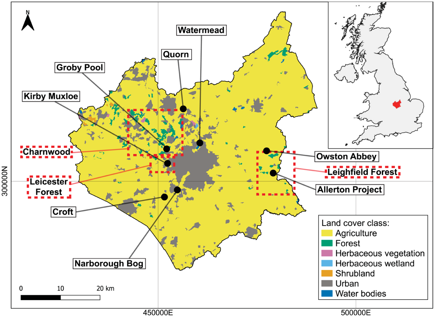
Map of CORINE land cover 2018 (coloured area) for Leicestershire © European Union, Copernicus Land Monitoring Service 2000, European Environment Agency (EEA). The main map shows the key pollen record locations studied here (black dots) and red dotted boxes highlighting two Royal Forests (Leicester Forest and Leighfield Forest) and a Medieval chase (Charnwood). Top right map shows the location of Leicestershire (red) in the United Kingdom. Contains OS data © Crown copyright and database right 2024. Coordinates in OSGB36.
Because of the long history of human interaction with the Leicestershire landscape, this paper develops an interdisciplinary approach to assess anthropogenic impacts on woodlands, assembling disparate, and often fragmentary datasets from palaeoecological (palynology) and historical (place-name) records. Some of these datasets have been studied at a disciplinary level before, but for others our analysis is new. Here we seek to address the following questions: (1) can a more detailed pattern of anthropogenic interactions with the landscape emerge from the examination and integration of diverse records; and (2) can such integration provide information on the continuity and resilience of certain ecologies and landscapes, despite prolonged anthropogenic stress?
Methodology
Palynology
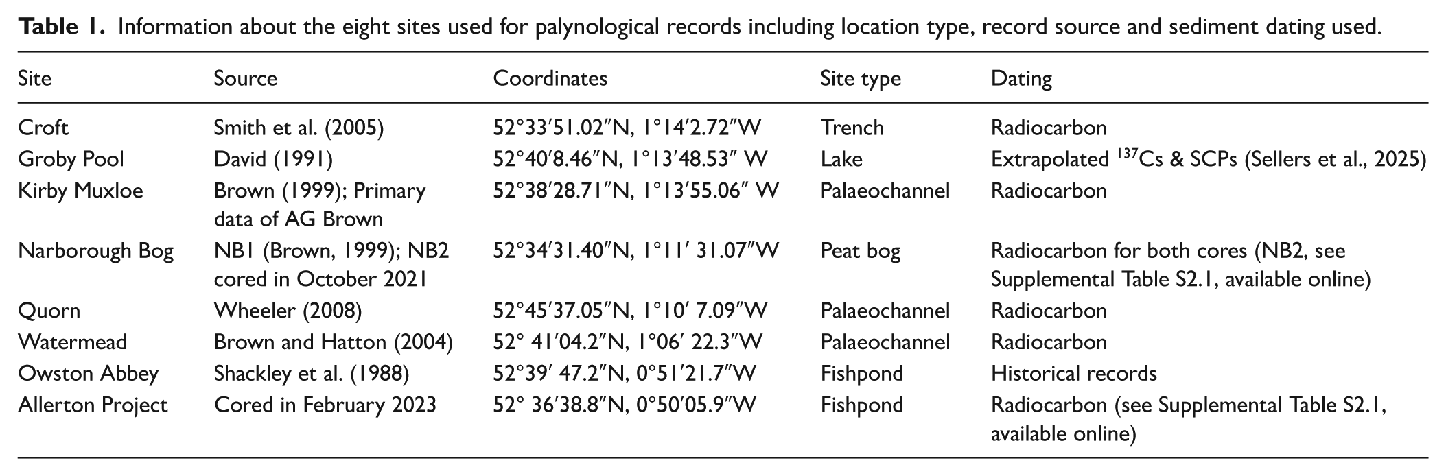
We analyze published and new palynological records from eight sites across Leicestershire (Table 1, Figure 1). Of these, six sites rely solely on existing data, being Croft, Groby Pool, Kirby Muxloe, Quorn, Watermead and Owston Abbey (see Brown, 1999; Brown and Hatton, 2004; David, 1991; Shackley et al., 1988; Smith et al., 2005; Wheeler, 2008). Three of the sites, Narborough Bog, Groby Pool, and Allerton Fishpond, have been chosen for direct comparisons between the palynological and toponymic records; new sediment cores were taken from two of these sites (Narborough Bog and Allerton Fishpond).
Information about the eight sites used for palynological records including location type, record source and sediment dating used.
Groby Pool is a 12 hectare shallow lake (~1.8 m depth) northwest of Leicester, surrounded by wet woodland, arable fields, and quarries to the east and located in Charnwood which was a Medieval chase (Table 1, Figure 1). David (1991) estimates the lake origin to be 13th century, most likely as a fish and millpond constructed by monks from Leicester Abbey, and provides a pollen record for a 4 m core (Core 31) taken in 1988 using a Livingstone corer (Livingstone, 1955). The top of the core was analyzed in higher resolution (at 1–5 cm intervals) until depth 135 cm, and in lower resolution below (David, 1991). The core was composed of silty clay from 400 cm before transitioning into black homogeneous organic-rich sediment (gyttja) at ~90 cm until the top of the core (David et al., 1998). The dating of Core 31 was estimated by correlation via pollen concentration to an adjacent core (see David, 1991 for correlation profile) where 137Cs and SCP profiles were used to establish a chronology until 1850, thereafter extrapolation was made using the average sediment accumulation rate for pre-1850 (see Sellers et al., 2025).
Narborough Bog is a 9-hectare site, including alluvial wet-woodland and peat bog, located on the floodplain of the River Soar and owned by the Leicestershire and Rutland Wildlife Trust. It has a complex bipartite stratigraphy and hydrological inputs from both groundwater and meteoric sources (Bradley and Brown, 1996). Our analysis integrates a previously published palynological record (NB1) dating back to ~8800 yr BP and is the only locality in Leicestershire to record the entire Holocene (Brown, 1999). Brown’s analysis focused on the interval below 50 cm at relatively low resolution, so a new ~1.5 m core (NB2) was taken in 2021 using a Russian D-Section peat corer to produce a higher resolution study, including the more recent record. At 158 cm, the core is composed of silty clay sediment before transitioning to reddish brown wood peat from 120 cm until black organic rich herbaceous peat sediment from 100 to 0 cm. The chronology of NB2 was established using radiocarbon dating (Supplemental Table S2.1, available online).
In 2023, a 1.4 m core (AL1) was collected using a gouge auger by the present authors from an old fishpond at the Allerton Project, an agricultural project located in Loddington (Figure 1) which had no known record of being dredged. There is a patch of trees dominated by Salix spp. (willow) next to the coring site, with the surrounding area being predominantly agricultural fields, with some fragments of ancient semi-natural woodlands within a ~2 km radius that were once part of the Royal Forest of Leighfield. From 140 to 114 cm, the core was composed of organic-rich clay sediment before transitioning to silty clay sediment at 114 cm until the top of the core. The radiocarbon dating (Supplemental Table S2.1, available online) shows that the majority of the core (8–114 cm depth) is ~1100–600 CE, with a hiatus below 114 cm before the bottom of the core (140 cm) dates to ~6800 BCE, meaning that most of the core sampled deposits much older than those of the fishpond sediments.
For both NB2 and AL1, pollen was extracted using a modified version of the method documented in Moore et al. (1991). Counting was undertaken using a Leica DM500 light microscope at ×400 magnification. A minimum of 300 pollen and spores were counted in intervals of 2–4 cm for the majority of both cores, changing to every 10 cm between 58 and 98 cm in NB2 as the pollen record aligned with the previous NB1 core.
Toponymy
As part of the work by the English Place-Name Society (EPNS), the collation of all place-names in Leicestershire, including major (towns, parishes) and minor (field) names, and the dates the place-names were recorded from written historical sources has been published in seven volumes (Cox, 1998, 2002, 2004, 2009, 2011, 2014, 2016). From these volumes, 332 parishes and townships across Leicestershire have been used in this study, looking at place-names in records mostly from the 1086 CE Domesday book to the 20th century. Some 211 woodland-related elements and their meanings (see Supplemental Document S1, available online) have been collated from two published volumes of English place-name elements (Smith, 1956a, 1956b), which are mostly of Old English or Scandinavian origin, and organized into 46 terms to represent their meanings, such as multiple elements meaning the same species or woodland type. These terms cover three main categories: general, clearance, and species terms. General terms include types, features and management of woodlands (e.g. wood, small wood, woodland glade), clearance includes terms of human disturbance (e.g. stumped area, felling, burning) and species includes the names of tree and shrub species (see Supplemental Document S1, available online).
Text mining was used to extract the woodland elements from digital versions of Cox’s (op. cit.) Leicestershire volumes and provide a presence/absence count for each parish and township. We used spatial autocorrelation, specifically join count statistics, to explore whether there are significant spatial patterns in place-names to indicate the significant presence or absence of woodlands and certain taxa. Join count statistics were used on binary presence/absence data on a univariate level to compare the presence or absence of woodland terms in neighbouring parishes and townships (O’Sullivan and Unwin, 2010). Spatial weights for selecting neighbours were generated using Queen contiguity (all parishes bordering the target parish) and centre-to-centre distance structure (all centroids of parishes within the specified distance from the target parish) testing the minimum distance threshold (3.34 km), 5 and 10 km radii. As there was no significant difference between the output join count ratios, we used the 5 km distance weighting for the join count statistics for three case study sites as it is representative. For the three case study sites (Groby Pool, Narborough Bog and Allerton Project), the dates of each woodland-related place-name from parishes and townships within 5 km were collated to provide a temporal account of when the place-name elements were first referenced (see Supplemental Table S2.2 and Figure S2.1, available online for list and map). Place-name elements in the text will be in bold and italicized, whereas binomial nomenclature names for organisms, as by convention, will just be italicized.
Results
Palynology
The palynology shows a fragmented record of landscape change over the past ~12,000 years across Leicestershire, however key patterns do emerge (Figure 2). Trees began to colonize over thousands of years with the first species arriving in the pollen record being Alnus (alder), Betula (birch) and Corylus (hazel), along with Pinus (pine), Quercus (oak), Tilia (lime) and Ulmus (elm) to create a tree-dominated landscape in the late Mesolithic (Figure 2a). For the next several thousand years, most sites suggest a consistent wooded landscape during the early and into the middle Holocene, with deforestation associated with Bronze Age landscape modification. Major deforestation events throughout the Bronze and Iron Ages resulted in a grassland dominated landscape through the Roman and into the Medieval period. The Watermead site shows continued deforestation during the Roman period (250–430 CE), however, the woodland is dominated by Pinus in the Iron Age to Roman period, which is uncommon in lowland Britain at that time (Bennett, 1984), although refugia are known to have existed on the free draining nutrient deficient soils of the New Forest, Breckland, and sandy areas of the gravel terraces of the River Severn (Brown, 1984). Potential reasons for this are that the soil conditions were favourable for Pinus growth or Pinus was left standing during woodland clearance prior to the start of the Watermead pollen record (~400−200 BCE) either because Pinus had little value at the time or it was specifically managed as a resource (Brown and Hatton, 2004).
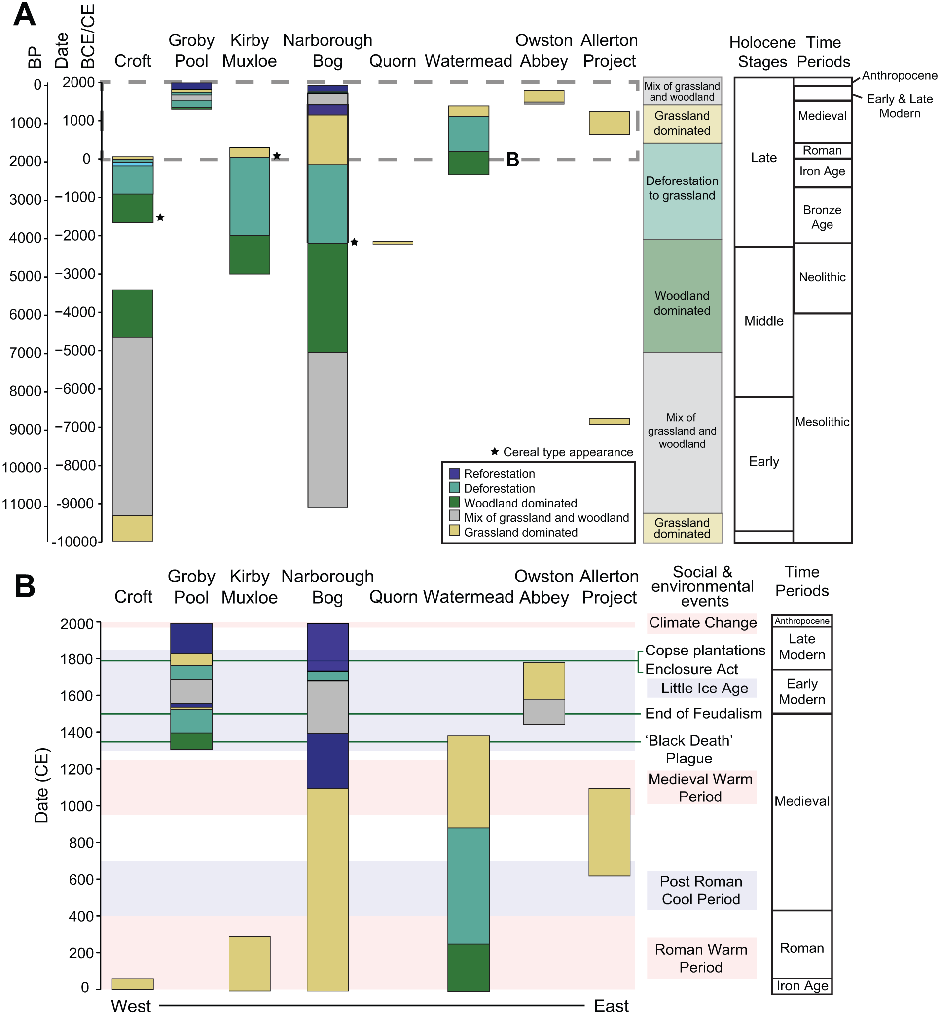
Landscape pattern from palynological records: 2A, over the Holocene to the Anthropocene (here used informally to denote the interval from the mid-20th century to present in Leicestershire, see Sellers et al., 2025) and 2B, focus on records from the year 0 CE to present. 2B includes environmental events using pink (warm temperature) and blue (cool temperature) shaded areas and green horizontal lines show a selection of historical events that could have impacted the local landscape.
Following deforestation, the landscape does not become tree-dominated again. From the late Medieval to present, there are localized afforestation events that vary at the different sites; however, the sites remain either grassland-dominated or become a mixture of woodland and grassland (Figure 2b). Within this period, there are further fluctuations in arboreal pollen from localized deforestation and reforestation, or woodland management which might cause tree cover to vary, such as coppicing of Tilia which suppresses pollen production (Waller et al., 2012). Common species are present in woodland from the Early Modern period including Alnus, Betula, Pinus, and Quercus, which were also recorded in the vegetation during the Mesolithic period. There is some variation in tree pollen species present in the Early Modern period which could be due to management practices, such as Pinus plantations and other tree planting, such as Larix (larch) and Taxus (yew), near Groby Pool and a Malus (apple) orchard near Owston Abbey near the Allerton site (David and Roberts, 1991; Shackley et al., 1988).
Toponymy
In Leicestershire, 98% of parishes and townships possess woodland terms in major and minor place-names across the three categories (general wood, individual species and woodland clearance terms). This highlights the cultural importance of woodlands in Leicestershire, despite the pollen record showing how fragmented they had become when the area was the classic heartland of the open field agricultural system (Champion landscape (sensu Williamson et al., 2013)).
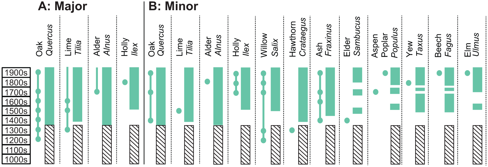
When examining place-names, excluding field names, there were differences before and after 1750 when Enclosure Acts began to be implemented in parishes where land ownership was consolidated and agriculture began to intensify (Squires and Jeeves, 1994). Before 1750, the distribution of wood terms (Figure 3a) was spread across the county, though focused on where fragments of ancient woodland (areas that have been continuously wooded since 1600 in England) were situated – mostly northwest and east Leicestershire. The presence of wood terms also focused on where royal forests were located with Leicester Forest in the west and Leighfield Forest in the east, the latter including parts of Rutland (Supplemental Figure S2.2A, available online). In comparison, small wood terms (Figure 3c) were found more sporadically across Leicestershire before 1750.
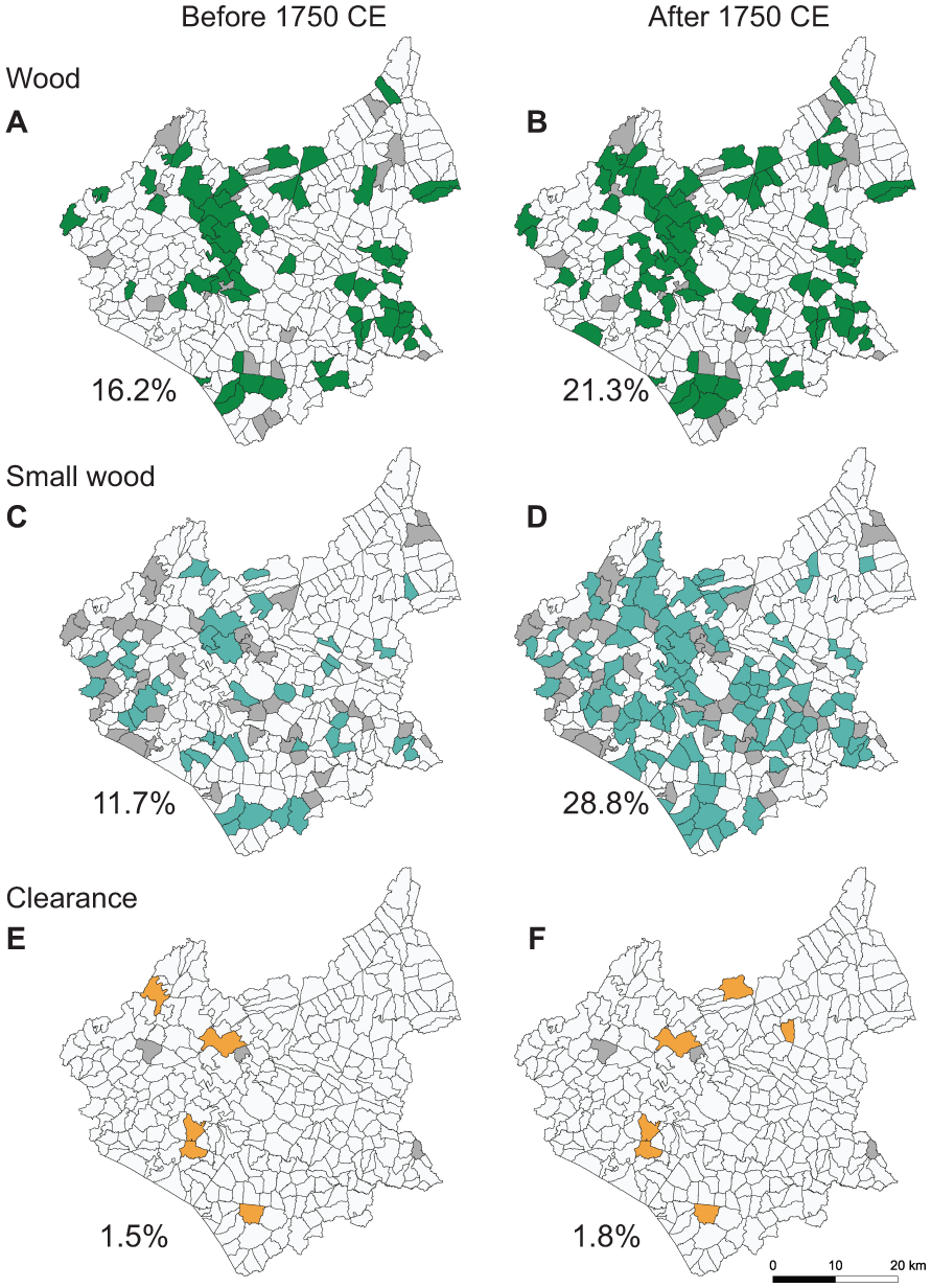
Presence of wood (A-B), small wood (C-D) and woodland clearance (E-F) terms in place-names (excluding field names) around Leicestershire, with the percentages of parishes and townships that have the terms present. The left column (A, C, E) shows the distribution of presence (coloured polygons) before 1750 while the right (B, D, F) shows after 1750 when Enclosure Acts began to be implemented in parishes. The dark grey polygons show presence of woodland place-names, however, the date could not be narrowed to before or after 1750. Leicestershire 1851 parishes and township boundaries used are adapted from Kain and Oliver (2020) to be in line with parishes and townships from Cox (1998, 2002, 2004, 2009, 2011, 2014, 2016). © Crown copyright and database right 2018 and 2024.
After 1750, the presence of both wood and small wood terms in place-names (excluding field names) increased (Figure 3b and d). This links to the pollen records which also show an increase in tree pollen, though this varies locally with fluctuations in tree cover. Furthermore, the notion of a “small wood” was present in a higher percentage than “wood” after 1750, which reflects the fragmented nature of woodlands in Leicestershire and also the deliberate planting in the 19th century of small copses as fox coverts in order to maintain an adequate fox population for hunting, which had its national centre in Leicestershire and Rutland. Nevertheless, some place-names with woodland related terms fell into disuse after 1750.
Woodland clearance terms were only recorded in less than 2% of parishes and townships before 1750, despite Leicestershire being a highly woodland-depleted landscape. This could be because most of the woodland clearance occurred prior to the development of those place-names (i.e. this landscape was already heavily deforested by the Bronze and Iron ages, implied by the pollen records). Or it may be that in more recent centuries, woodland clearance “events” occur over too short a timescale to pass into place-name evidence and are thus underrepresented by these descriptive terms, since they are not recorded over longer periods of time as the land became repurposed or the vegetation returned (Kadmon, 2000). After 1750, there was only a slight change in the parishes where clearance terms are present, with the loss of a term in one parish in the northwest and the addition in two parishes in the north of the county (Figure 3e and f).
When analyzing spatial autocorrelation, the join count ratio for “small wood” terms was higher after 1750 than before, with 34% of parishes and townships having neighbours in a 5 km radius with “small wood” terms also present in the place-names (excluding field names) (Supplemental Figure S2.2D, available online). This was higher than general “wood” terms where 28% of parishes and townships with the term had neighbours with that term after 1750 (Supplemental Figure S2.2B, available online). Before and after 1750, there is significant clustering of “wood” terms around northwest Leicestershire, where Charnwood Forest (including an important Medieval to historic period deer park) and the Leicester Royal Forest are located, and the clustering increases after 1750. However, in east Leicestershire, the clustering around Leighfield forest becomes weaker and sparser in the join count statistics (Supplemental Figure S2.2B, available online), reflecting further deforestation in that area occurring before the 18th century. Before 1750, there was no significant clustering for the “small wood” terms, however there is significance after 1750 east of the city of Leicester and other parishes spread around the county (Supplemental Figure S2.2, available online), which highlights the sporadic distribution of woodland fragments and planted copses across the county.
Next, we use a case study approach to examine major and minor place-names on a local basis and examine species in place-names at these case study areas (Figure 4), in comparison to the pollen records.
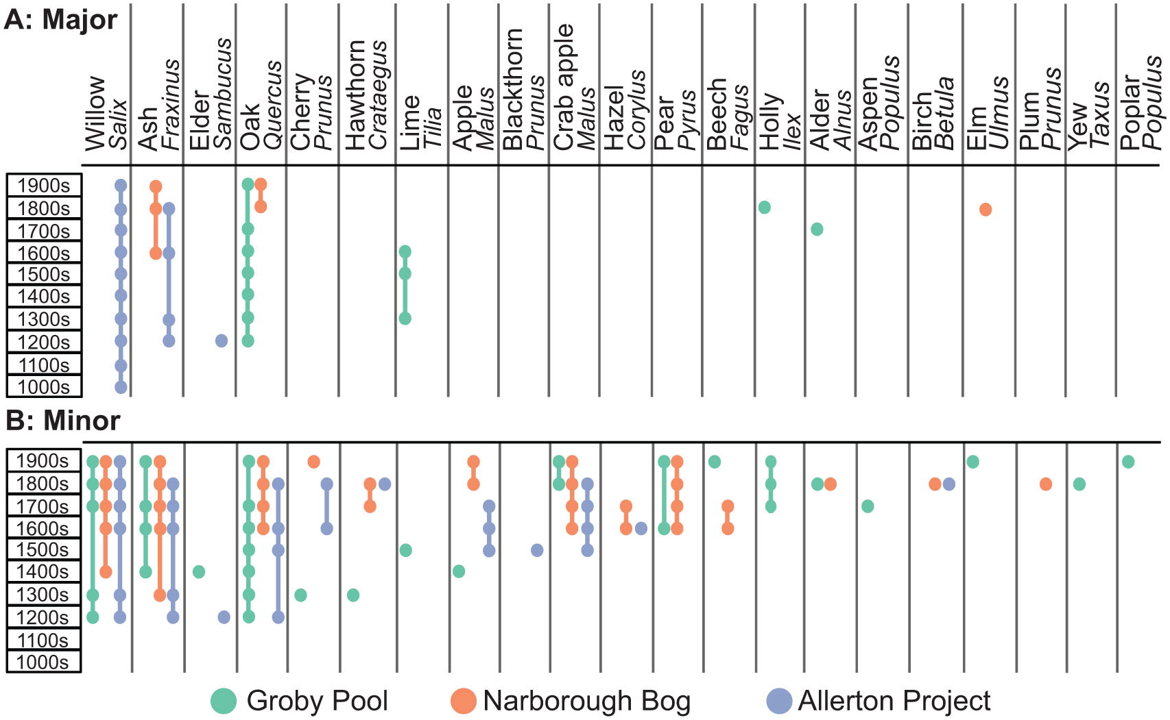
Temporal place-name diagram showing the presence of recorded terms relating to species in major (A) and minor (B) place-names from parishes and townships within a 5 km radius of the pollen sites: Groby Pool (green), Narborough Bog (orange) and Allerton Project (blue). The dates are provided in Common Era (CE) format. See Table S2.2 and Figure S2.1 for list and map of the parishes and townships included in each case study.
Ground-truthing the place-name data; case study 1, Groby Pool
Groby Pool pollen record covers the past 600 years from the 15th century (Figure 5, Supplemental Figure S2.3, available online). At the start of Zone 1, arboreal pollen (Quercus, Corylus and Alnus) contributed up to 50% of the total until deforestation in the ~1400s (Supplemental Figure S2.3, Zone 2, available online). Within Zone 2, there is a slight increase in Quercus and Corylus pollen in the 1500s, with constant presence of Alnus and traces of Betula, Fraxinus and Salix, before Corylus decreases into the 1600s. This is followed by a major decline in Quercus pollen from the mid-1600s with an increase in Poaceae. The second decrease of Quercus after ~1750 is likely linked to an increase in agricultural land following the Parliamentary Act of Enclosure (David et al., 1998; Woodward, 1984). Zone 3 is dominated by open landscape, with some tree cover until the 1800s where arboreal pollen increases (Supplemental Figure S2.3, Zone 4, available online). Zone 4 shows an increase in woodland cover; however, the landscape does not become woodland dominated again. Furthermore, there is an increase in tree diversity with the addition of taxa such as Populus, Taxus and non-native species such as Aesculus (horse chestnut) and Cedrus (cedar) pollen (<1%) in the mid-20th century, which aligns to the records of re-planting in the area.
Comparison of tree and shrub species present in the Groby Pool pollen record (Latin names; shaded green bars) and place-names (English names; lines and dots) from parishes and townships within a 5 km radius of Groby parish. 5A shows presence in major place-names and 5B shows minor place-names. The Core 31 pollen record (from Groby Pool, see Sellers et al., 2025) has been used for comparison to both. The dates are provided in Common Era (CE) format. A black hashed area has been added to indicate where no pollen record is available, as the Core 31 pollen record starts from ~1400 CE.
In Groby parish, where Groby Pool is located, alder (Alnus) is present in a major place-name, and four other species are present in minor place-names, aspen (Populus), cherry (Prunus), oak (Quercus) and poplar (Populus). This overlaps with the presence of Alnus, Quercus and Populus in the Groby Pool pollen record (Figure 5). For example, Alder Spinney (
There is variation in whether pollen records from the lake sediments or historical place-name evidence provides the earliest record of a plant. For example, elm (Ulmus) increases in the pollen record in the early 1800s but appears in the place-name record as the field name Elm Tree Field in 1968 at Newtown Linford, which could suggest that while elms are in the surrounding area, they could be located as individual trees in the landscape. Yew (Taxus) is recorded in the field name Yew Close (
Case study 2, Narborough Bog
Narborough Bog contains the longest environmental record of the Holocene in Leicestershire (Figure 6). The NB1 core record shows Pinus and Betula being present in the early Mesolithic, followed by Alnus and Corylus dominating between ~7500 and 4750 yr BP, before a decrease in arboreal pollen and increase in Poaceae (Brown, 1999). The NB2 core supports this record by showing a consistent Alnus and Corylus dominated woodland with Pinus, Ulmus and Betula established by 7500 cal. BP, and consistently present for thousands of years before deforestation in the Bronze Age (Figure 2a), creating an open landscape (Figure 6, Zone 1 to 2). The surrounding area remains grassland dominated (Supplemental Figure S2.5, available online) until ~1100 CE when Quercus pollen increases, with some Salix, Betula, Pinus and Alnus (Figure 6, Zone 2 to 3). The arboreal pollen composition of the recent woodland in the pollen record (Quercus >35% of total land pollen) is different from the long history of the local woodland (Alnus and Corylus dominated) in the Mesolithic-Neolithic period.
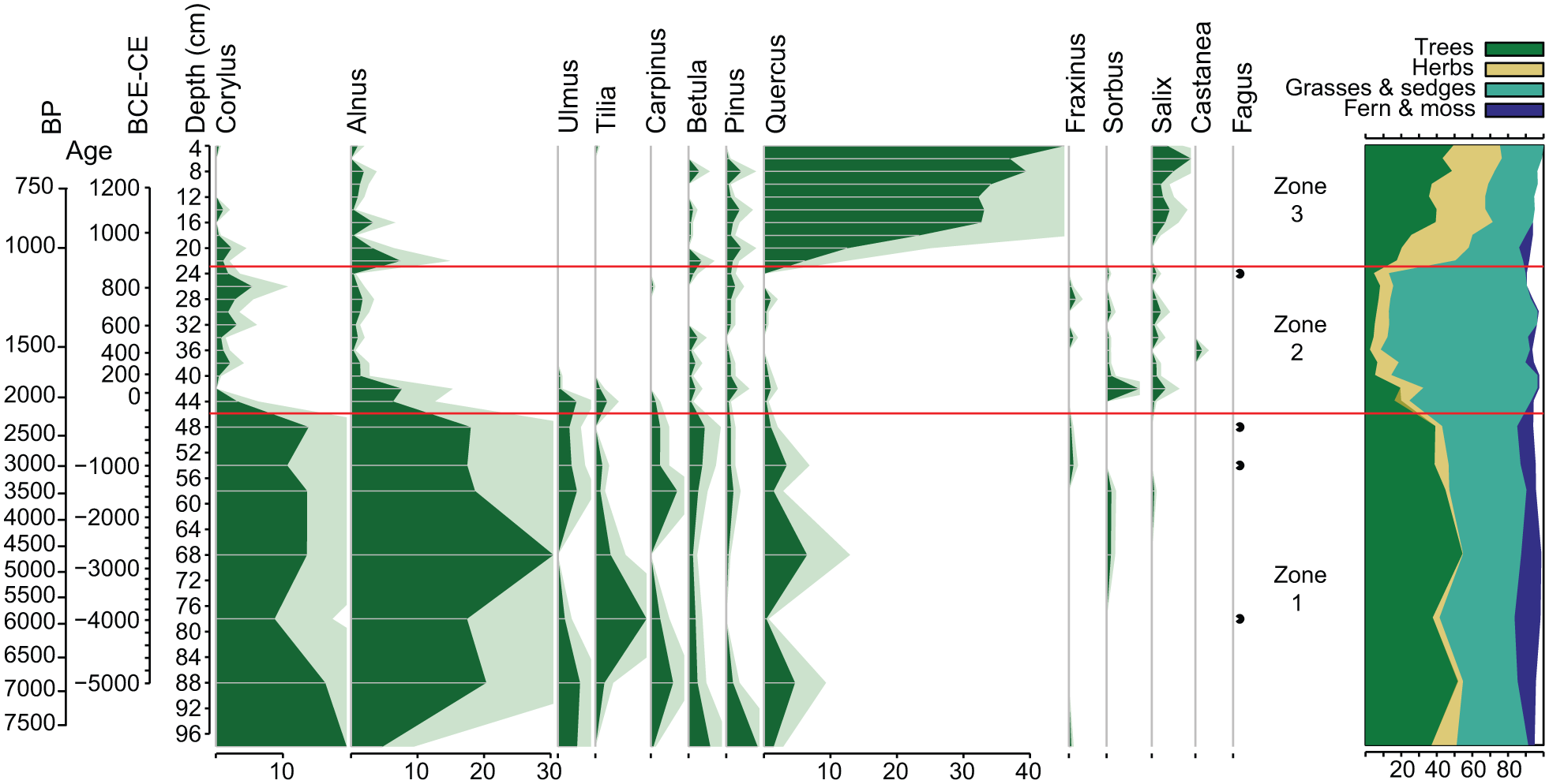
Arboreal pollen diagram from Narborough Bog core NB2, showing the top 98 cm of the core. Black dots show presence <1% of the total land pollen and spores (TLPS). Red lines show pollen assemblage zones from hierarchical clustering. Ages (in cal. BP and BCE/CE) are extrapolated from radiocarbon dating. The cumulative plot (right) shows the different types, including trees (dark green), herbs (yellow), grasses & sedges (teal), ferns & mosses (dark blue) and unknown (white).
Major place-names in Narborough Parish refer to two species (elm and oak) and minor names refer to seven (alder, crab apple, hawthorn, hazel, oak, pear, and willow). Five of these species also occur in the pollen record (alder (Alnus), elm (Ulmus), hazel (Corylus), oak (Quercus) and willow (Salix)) (Figure 4). Beyond Narborough, birch (Betula) is present in place-names within Blaby parish in 1849 (~2.5 km from NB). The minor place-name Copt Oak (
General woodland terms are present in place-names within 5 km of NB since Domesday (1086 CE), with “small wood” being present from the 1400s (Supplemental Figure S2.4, available online). Clearance terms, such as stumped area and felling, are referenced from the 1500s, even though the pollen record shows felling in the local landscape a few thousand years beforehand. Terms relating to human management of woodlands are present more in the early and late modern periods, including coppice (from 1600s), orchard (1700s), plantation, covert, and pollard (1800s).
Case study 3, Allerton Project
Dating of the Allerton Project core AL1 indicates that most of the upper core (between 8 and 114 cm) spans ~1100–600 CE. There is a hiatus at 114 cm, with the deposits of the bottom of the core (at 140 cm) being ~6800 BCE (~8750 cal BP) old (Figure 7). The record suggests that the landscape was mostly open with some tree cover at ~6800 BCE (Mesolithic). Pinus is present at ~20% of the total, which is consistent with Brown and Hatton’s (2004) suggestion of the presence of regional mid-Holocene pine forests. Following a large gap in the record due to the hiatus, grassland is dominant during the Medieval period, with Poaceae contributing to 30–50% of the total with peaks at 100 and 64 cm (estimated ~650 CE and ~800 CE respectively) (Supplemental Figure S2.6, available online). No significant pollen assemblage zones were found using CONISS, emphasizing the long history of open landscape, particularly in the Medieval period. Pinus continues to fluctuate throughout the record, which is unusual for lowland central England. The other tree taxa are present at relatively low concentrations with all, except Salix, staying under 10%. Alnus increases from 84 cm (estimated ~715 CE) and peaks in 44 cm (~885 CE). Pteridium (bracken) is present throughout the record with peaks at 136 cm, 96–88 cm (around the late 600 s CE) and 80 cm (around mid-700s CE), which could suggest disturbance or burning in the landscape (Supplemental Figure S2.6, available online). Fluctuations in the tree records could indicate disturbances and burning on a small scale.
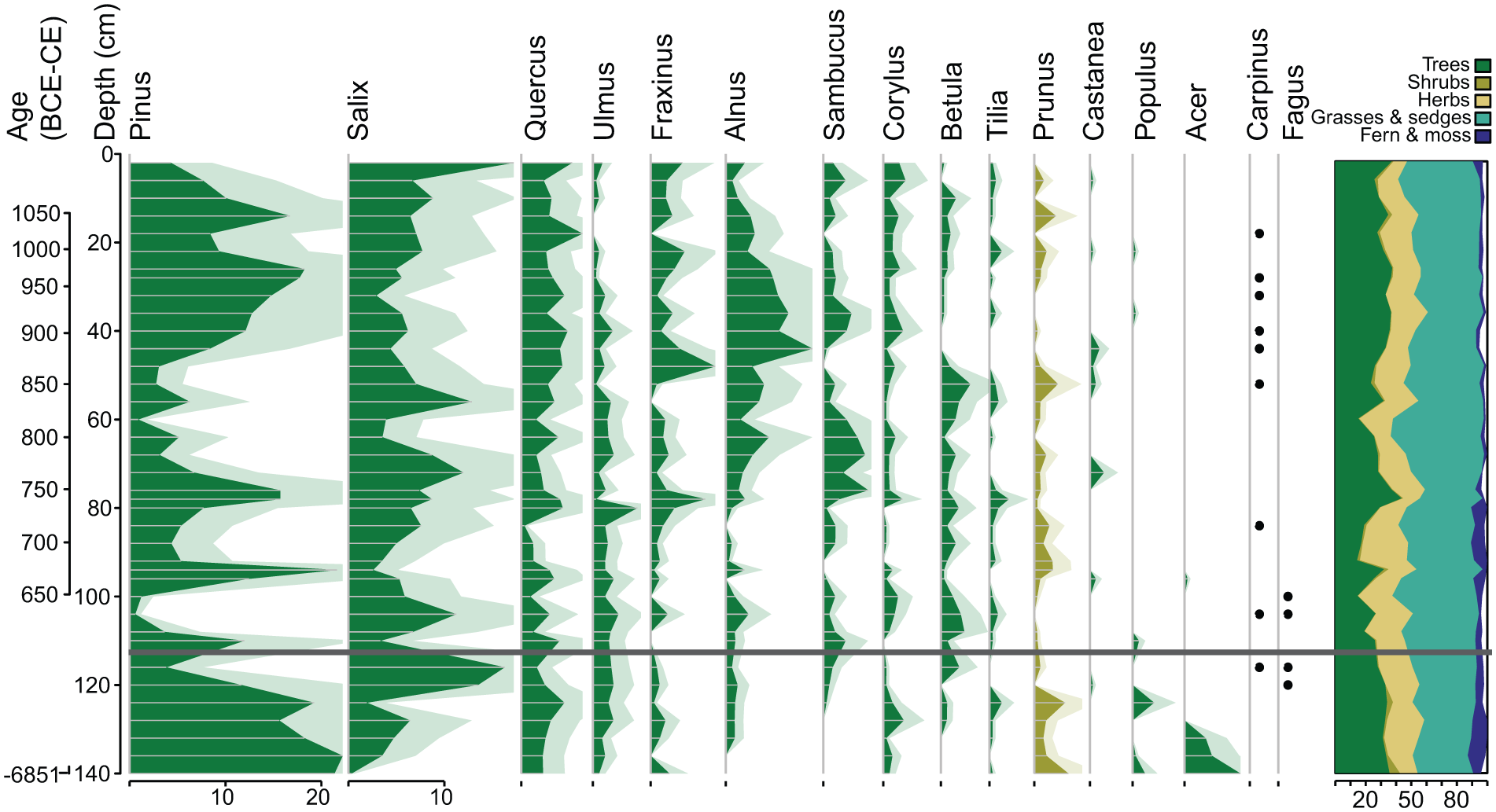
Arboreal pollen diagram of AL1 core. Black dots show presence <1% of the total land pollen and spores. Exaggeration curves have been added with silhouettes to highlight changes. The dates are provided in Common Era format (negative numbers are BCE and positive are CE), extrapolated from radiocarbon dating. The dark grey line indicates a hiatus after 114 cm. The cumulative plot (right) shows the different types, including trees (dark green), herbs (yellow), grasses & sedges (teal), ferns & mosses (dark blue) and unknown (white).
In Loddington parish where the Allerton Project is located, there are no species in major place-names, however six species are present in field names (apple, ash, cherry, crab apple, hawthorn and oak) of which two also occur in the pollen record: ash (Fraxinus) and oak (Quercus) (Figure 4). Despite having the highest arboreal pollen percentage (up to 22%), pine (Pinus) is not present in place-names from the surrounding parishes within the 5 km radius, which is most likely due to the well-known elevated long-distance transport component in predominantly open environments (Poliakova et al., 2024). Furthermore, willow (Salix) has one of the higher arboreal pollen percentages in the record and while it does not appear in Loddington parish, it does appear in 6 out of 12 parishes and townships within the 5 km radius; for example, there is a parish called Withcote (
The place-name record can provide more details about local woodlands beyond the dated pollen record. General wood terms in place-names are recorded in the Loddington parish from the 1300s, and woodland of around 0.5 league by 4 furlongs is recorded in the Domesday Book (Morris and Morgan, 1979). A neighbouring parish, Leighfield, whose name has evolved from
Discussion
Landscape evolution in Leicestershire
Woodlands have a long history in the Leicestershire landscape, which is evidenced from palynological records. Palynological records suggest the development of mixed deciduous woodlands in the Early Holocene with constant, dominant woodland cover through to the Middle Holocene, until extensive deforestation occurred during the Late Holocene (from the Bronze Age) in Leicestershire, leaving an open landscape with limited tree cover. Arboreal pollen starts to increase again from the late Medieval period, suggesting localized reforestation, leading to a mixed landscape of grassland and woodland from the Early Modern period. However, woodlands remained a minor component of the landscape.
For lowland central England, it is believed that the wildwood was dominated by Tilia (lime) before the Neolithic, with a mixture of other tree species creating different localized types of woodland, being dominated by a variety of species: Acer (field maple), Alnus (alder), Corylus (hazel), Fraxinus (ash), Pinus (pine), Quercus (oak) and Ulmus (elm) (Rackham, 2020). These species are found in the Leicestershire pollen records with NB1 and Croft showing the presence of Tilia woodland persisting from the Early Holocene for several thousand years (Brown, 1999; Smith et al., 2005). Woodbridge et al. (2014) suggested that the Neolithic agricultural transition in Britain occurred in stages, with an initial change between ~6000 and 5300 cal BP for woodland clearance, followed by further disturbance between ~4400 and 3400 cal BP. The reduction in Tilia pollen observed in the Croft and Narborough Bog (NB1 and NB2) pollen records supports the suggested decline of Tilia pollen across lowland Britain, starting from the late Neolithic to the Bronze Age, with further decline after the Iron Age due to the loss of primary woodland (Grant et al., 2011). A widespread decrease in Ulmus is also recorded across the British Isles from ~6300 to ~5300 cal BP (Neolithic) and is suggested to be caused by a disease outbreak exacerbated by broader environmental and anthropogenic factors (Parker et al., 2002). The Croft pollen record only has a low, sporadic presence of Ulmus (<1%) so this decline is not observed, however the Narborough Bog NB2 record does show an Ulmus reduction in the Neolithic (mid-6000s to ~5000 cal BP), with further decline in the Bronze and Iron ages (in NB1 and NB2).
Along with deforestation, the appearance of agricultural indicators such as cereals indicate a change in land use in the local landscape. Brown (2007) reports charred cereal grains appearing in Britain from 4000 BCE, with a peak between 3800 and 3500 BCE, however Leicestershire pollen records in this study identify cereal pollen later, from ~4300 yr BP (Brown, 1999, dates quoted in the format of original references). In another archaeological study, cereal pollen was dated to the late Neolithic (~2800 BCE) in Hemington Quarry in the north of Leicestershire, however cereal pollen has been identified in the East Midlands region from ~6000 yr BP at Buxton in Derbyshire, which matches the proposed timeline across Britain (Monckton, 2004). While the cereal pollen at the sites in this study are found later, the timing does align to the start of deforestation in the local area, showing major anthropogenic disturbance from the Neolithic.
By the time that the Romans arrived in Britain, it is suggested that there was already a lack of woodlands in the landscape and cereals were widely used (Dark, 1999), which matches the open landscape seen in the Leicestershire pollen record. The exception is Watermead (on the northern edge of the city of Leicester) where an unusually high percentage of Pinus (pine) pollen is present after the Bronze and Iron ages. Potential explanations have been suggested, such as the presence of favourable soils nearby, the survival of a small Pinus refugia or Pinus was left standing during other woodland clearance, or either because it was a valuable resource or because it had little value (Brown and Hatton, 2004). Furthermore, Pinus pollen is found fluctuating throughout the Allerton fishpond (AL1) record during the early Medieval period which is also unusual, and pine is not in the place-names within the surrounding area (5 km radius). Pinus pollen has been found to travel up to ~6 km from a small population (~36 trees) or over 100 km from larger pine forests (Robledo-Arnuncio and Gil, 2005; Szczepanek et al., 2017), so it is possible that there was a Pinus refugium present in the wider region that could have been managed, similar to that inferred at Watermead.
By the Medieval period, remaining English woodlands were heavily managed, for example used for coppice and underwood – mainly for fuel, building and fencing. In England, many Royal Forests, areas of land including woodland, heathland, pastureland and sometimes villages, were founded in the 11th and 12th centuries (Squires, 2011). These areas were owned by the monarch and managed under specific laws, largely as hunting grounds, to protect deer, boar, and their habitats (Squires, 2014). In Leicestershire, there were two Royal Forests, Leicester Forest and Leighfield Forest, from ~1100 to 1235 CE when the land was released from Forest law (Squires and Jeeves, 1994). These forests and many Medieval deer parks were surrounded by open fields under strip-rotation and fallow systems. Many medieval buildings used timber with oak (Quercus) being the most common species, followed by elm (Ulmus), ash (Fraxinus) and aspen (Populus), and “rods” and “poles” were required for building and stock control (Rackham, 2020). From the 16th century, the need for timber grew as the demand for ships and iron smelting increased with trade and increasing population, with the height of timber demand between the 17th and 18th century for shipbuilding, particularly oak (Holmes, 1975). These could be explanations for why oak was prominent in the recent Narborough Bog NB2 pollen record.
Woodland management strategy shifted in the late 19th to 20th century throughout Britain from traditional practices, such as having complex mixed species woods using relatively small-scale coppicing, planting, and felling, to having monoculture plantations with non-native species that were fast growing to maximize production (Tsouvalis et al., 2000). Some of these non-native species (such as Cupressus and Larix) are recorded in the Groby Pool pollen record, likely reflecting the development of spinneys and plantations in the surrounding area, however other non-native species observed to be present today in the surrounding area are not recorded in the pollen record, such as Tsuga and Thuja (David and Roberts, 1991). At present, pockets of woodlands persist in Leicestershire, however there is no undisturbed, primary woodland remaining, as indeed for the rest of the UK.
Throughout history, there have been many social and environmental events that could have impacted woodlands in the Leicestershire landscape (Figure 2b). The general pollen pattern across Leicestershire does not show significant direct impact from environmental episodes such as the Roman Warm Period, Post Roman Cool Period, Medieval Climatic Anomaly, or the Little Ice Age. Furthermore, little effect from some of the historical events can be seen in the pollen record, such as the Black Death in 1348, which is estimated to have reduced the Leicester population by around half (Britnell, 1994), and the economic shift from ~1500 toward capitalism (Bending and McRae, 2003). The Groby Pool pollen record shows a slight reduction in tree pollen following the Enclosure Act in ~1789 (Woodward, 1984). The land enclosure in Narborough occurred in 1752 (Jarrett and Jarrett, 1981), however little change is seen within the Narborough Bog pollen record, with one explanation that given the relatively slow accumulation rate of the peat there, it might be difficult to capture events on the sub-centennial timescale. Owston Abbey fishpond pollen record (Figure 2) also does not show any change at the time of the Enclosure Act, however the estate land had already been given to the farmers after the dissolution of the Abbey in 1536, so the small pollen catchment area of the fishpond was likely already open landscape with limited tree cover, which is evidenced in the pollen record (McKinley, 1954; Shackley et al., 1988).
Toponymy is a useful tool when combined with palynology to understand landscape evolution in Leicestershire
Detailed palynological datasets from Leicestershire are limited to just eight (Figure 2), and each takes considerable time to assemble. Therefore, the analysis of other datasets can help to construct a broader understanding of landscape change in Leicestershire. Comparison of place-name and palynological data at Groby Pool, Narborough Bog and Allerton Fishpond show that palynological and place-name evidence for the local landscape show high consistency for the historic period. This suggests that place-name evidence is useful to understand the local landscape, even in the absence of other data. For example, we have shown that at Loddington (Allerton Project) in East Leicestershire the place-name record provides evidence of the continuity of woodlands, and of forest clearance, in the late Medieval period beyond that available from the palynological evidence in the Allerton Project Core (AL1).
Place-names do represent some of the woodland change and species present as reconstructed from the pollen record, however, there are some discrepancies with the pollen record. One reason for the difference in the pollen record could be woodland management practices, such as coppicing, which has been found to affect pollen productivity. For example, managed hazel (Corylus avellana) shows an increase in pollen during early regrowth, however, with alder (Alnus glutinosa) and small-leaved lime (Tilia cordata) coppicing has been shown to reduce pollen production, which could provide a reason for why some species are in place-names but low concentration in the pollen record (Bunting et al., 2016; Waller et al., 2012). Other limitations with place-names are the several possible reasons behind the naming process. For example, name elements could have been chosen by noticeable features, but it can be unclear whether that feature is continuous over one area (e.g. a wood abundant with one species) or small and distinctive (e.g. one lone tree) (Cogos et al., 2019). There can also be a delay between names coming into use and names being recorded in a surviving written record, which can impact the chronology of the historical records (Sousa and García-Murillo, 2001). The place-names are historically based on Old English so using modern English language to analyze the words can result in translation issues for many words and assumptions are made on the reasoning behind the name elements (Jones, 2016; Sousa and García-Murillo, 2001). Furthermore, the meaning or features could have changed over time from the original naming which affects interpretation (Kadmon, 2000). Despite these limitations, there is clear synergy between both the place-name and pollen evidence when looking on a case study basis in Leicestershire that enables a more detailed understanding of landscape evolution at a particular site (Figure 5).
Orchards are present in the place-name record throughout Leicestershire, suggesting cultural and economic importance. This is true across England where orchards have historically been important to society, especially in the mid-19th century (Williamson, 2020). “Orchard” does appear in the Groby Pool and Allerton case studies place-name records from the 1400s, showing a longer history. Fruit trees are also found in the place-names of the three case study sites (such as apple, crab apple, pear and cherry), however the pollen of these taxa is not recorded. A potential explanation for this is that fruit trees are mostly insect-pollinated, so the pollen has a low dispersion mechanism (Quinet and Jacquemart, 2017). However, the Owston Abbey fishpond pollen record does identify an increase in apple (Malus) pollen from an orchard development in ~1793 CE, as referenced in historical records, which is likely to be recorded due to the proximity between the orchard and the pond (Shackley et al., 1988).
Conclusions
This study sought to address two questions: (1) can a more detailed pattern of anthropogenic interactions with the landscape emerge from the examination and integration of diverse records; and (2) can such integration provide information on the continuity and resilience of certain ecologies and landscapes, despite prolonged anthropogenic stress? In answer to question 1, we have shown that a combination of palynology and toponomastics provides a broader record of past landscape evolution and the connections to anthropogenic influences in the Leicestershire landscape, UK. We have demonstrated that place-name evidence, when ground-truthed in the local landscape with palynological data from well-dated cores, can be used to infer the record of landscape change. In Leicestershire, it can therefore be used to improve the inferred record about historical period landscape evolution even in the absence of palynological data, for example at Loddington (Allerton Project) in East Leicestershire. Secondly, in answer to question 2, our analysis in Leicestershire shows that despite major anthropogenic disturbance over millennia, and the lack of any continuous primary woodland, pockets of woodlands remain and that by utilizing traditional human-woodland interactions, such as coppicing, it is possible to support the conservation and sustenance of this broadleaf biome. Finally, we note that the combined palynological-toponymic approach here could be extended to explore past landscape change focusing on other aspects such as water or agriculture, and to examine forests and their relationship to humans elsewhere in the world.
Supplemental Material
sj-docx-1-hol-10.1177_09596836251387254 – Supplemental material for Evidence of long-term woodland persistence despite prolonged anthropogenic stress: The combined use of pollen and place-names in lowland Leicestershire, UK
Supplemental material, sj-docx-1-hol-10.1177_09596836251387254 for Evidence of long-term woodland persistence despite prolonged anthropogenic stress: The combined use of pollen and place-names in lowland Leicestershire, UK by Hannah Sellers, Juan Carlos Berrio, Stef De Sabbata, Richard Jones, Angharad Evans, Antony G Brown and Mark Williams in The Holocene
Supplemental Material
sj-xlsx-2-hol-10.1177_09596836251387254 – Supplemental material for Evidence of long-term woodland persistence despite prolonged anthropogenic stress: The combined use of pollen and place-names in lowland Leicestershire, UK
Supplemental material, sj-xlsx-2-hol-10.1177_09596836251387254 for Evidence of long-term woodland persistence despite prolonged anthropogenic stress: The combined use of pollen and place-names in lowland Leicestershire, UK by Hannah Sellers, Juan Carlos Berrio, Stef De Sabbata, Richard Jones, Angharad Evans, Antony G Brown and Mark Williams in The Holocene
Footnotes
Acknowledgements
This work is funded through a University of Leicester College of Science and Engineering PhD studentship to Hannah Sellers. The original concept for this project was developed through the Leicester Institute for Advanced Studies project, “Reimagining the Homogenocene as a safe and resilient place for life on Earth.” We thank: the National Environmental Isotope Facility (NEIF) for funding the radiocarbon dating of the Narborough Bog (NB2) and Allerton (AL1) cores under grants NE/S011587/1 (allocation number 2502.0422) and NE/S011587/1 (allocation number 2676.0923), and performing the radiocarbon measurements at NEIF Radiocarbon Laboratory at the Scottish Universities Environmental Research Centre (SUERC); The Leicestershire and Rutland Wildlife Trust and the Allerton Project in the Game & Wildlife Conservation Trust for giving permission to core their sites for palynological analysis; Jayne Carroll (University of Nottingham, English Place-Name Society) for providing digitized versions of the Barrie Cox books; and Maxine Towler (University of Leicester) for her work to support the palynological laboratory work in sample extraction and slide preparation for part of the Narborough Bog NB2 core. Dorian Marczykowska, Freya Douglas and Saf Owsnett helped with palynological laboratory work for part of the Allerton AL1 core.
Author contributions
Funding
The authors disclosed receipt of the following financial support for the research, authorship, and/or publication of this article: This work is funded through a University of Leicester College of Science and Engineering PhD studentship to Hannah Sellers. The original concept for this project was developed through the Leicester Institute for Advanced Studies project, “Reimagining the Homogenocene as a safe and resilient place for life on Earth (to MW).”
Data availability statement
Previously published data is available at original sources (as referenced). Data from new cores (NB2 and AL1) is available with Hannah Sellers’ PhD thesis, “Resilient, biodiverse forests in an Anthropocene landscape” on the University of Leicester’s Research Archive.
Supplemental material
Supplemental material for this article is available online.
References
Supplementary Material
Please find the following supplemental material available below.
For Open Access articles published under a Creative Commons License, all supplemental material carries the same license as the article it is associated with.
For non-Open Access articles published, all supplemental material carries a non-exclusive license, and permission requests for re-use of supplemental material or any part of supplemental material shall be sent directly to the copyright owner as specified in the copyright notice associated with the article.