
Abstract
Climate change is expected to increase the frequency and severity of wildfires in boreal forests, raising concerns about ecosystem resilience. We investigated the correspondence between fire events and soil erosion events in northern Finland during the Holocene (last 11,000 years). We analysed charcoal particles to reconstruct the local fire histories of two boreal lake catchments. Then, using magnetic susceptibility analysis, we identified sedimentary inputs into the lakes due to soil erosion events. Sediment geochemistry analysis revealed that high-severity fires corresponding with soil erosion events not only affect the organic soil horizons, but also the topmost mineral horizons by leaching aluminium, calcium, nitrogen, silicon and heavy metals into aquatic ecosystems. Because the effects of high-severity fires on soil properties are long-lasting, increased fire severity under climate change in northern Finland could hamper forest resilience in addition to contaminating aquatic ecosystems.
Introduction
In boreal environments, wildfires cause total or partial combustion of the organic soil horizons, leading to loss of essential nutrients, including exchangeable cations (e.g. Ca2+, Mg2+, K+), released both as emissions during fire and later as post-fire runoff (Agbeshie et al., 2022; Bladon et al., 2014; Certini, 2005; González-Pérez et al., 2004; Granath, 2021). Moreover, pH increases in post-fire disturbed soils, disrupting microbial communities, increasing heavy metal concentration, and causing depletion of some chemical elements (Bastianelli, 2018; Certini, 2005; Chebykina et al., 2024; González-Pérez et al., 2004).
Fire effects on soil physical and chemical properties depend on fire severity, which is expected to increase in boreal forests due to climate change (Gaboriau et al., 2020; Jain et al., 2022; Lehtonen et al., 2016; Williams et al., 2023). Increased fire severity could have long-term effects on the structure and chemical composition of boreal forest soils, delaying post-fire forest recovery and affecting ecosystem resilience (Bowman et al., 2020; Certini, 2005; Chebykina et al., 2024; Granath, 2021; Haukenes et al., 2022; Kelly et al., 2023; Maynard et al., 2014; Pellegrini et al., 2022). However, while studies have suggested that fire can affect soil erosion by wind or water (Carcaillet et al., 2006; Certini, 2005; Seppälä, 1981, 1995), the exact role of fire severity on these processes remains poorly investigated. Studying the relationship between fire severity and soil erosion during the Holocene could improve our understanding of how future fire regimes will affect boreal soil properties and vegetation composition.
In northern Finland, boreal forests are mainly composed of Scots pine (Pinus sylvestris), Norway spruce (Picea abies), and birch species (Betula spp.), whose relative dominance varies according to climate, elevation, fire regime and soil conditions (Aakala, 2018; Kuuluvainen et al., 2017; Naud et al., 2019; Rolstad et al., 2017; Stivrins et al., 2019; Yrjölä, 2002). Throughout the Holocene, fire regimes in northern Finland were mainly characterized by frequent, low-severity surface fires (Aakala, 2018; Kuuluvainen et al., 2017; Lacand, 2023; Seppä et al., 2009; Wallenius et al., 2010). However, high-severity crown fires occurred sporadically during warm and dry periods in pine-dominated forests, and during cool and wet periods in spruce and birch mixedwoods (Brown and Giesecke, 2014; Clear et al., 2014; Kuuluvainen et al., 2017; Lacand et al., 2023; Nahkiaisoja, 2006; Remy et al., 2023;Wallenius et al., 2010). Palaeoecological reconstructions (Lacand et al., 2023; Remy et al., 2023) have shown that the Early Holocene (before 8200 cal. BP) was cold and humid with mainly tundra vegetation (shrubs and grasses). Fire activity was very low. The warm and dry Middle Holocene (8200–4200 cal. BP) was favourable to Scots pine establishment and experienced a gradual increase of fire activity dominated by surface fires. Then, the Late-Holocene (after 4200 cal. BP) was cooler and wetter, promoting a switch to spruce dominance and an increased proportion of crown fires.
Regional-scale climate, fire and vegetation reconstructions are useful as they highlight broad variations in fire activity over the Holocene, but local-scale studies are needed to directly assess the effect of fire severity on ecosystem processes such as soil erosion. Hence, we investigated the correspondence between fire and soil erosion events over the Holocene in northern Finland using geophysical and geochemical analyses of lake sediments extracted from a pine stand and a mixed pine–birch stand. Because lake sediment composition is strongly regulated by terrestrial inputs, alterations of the catchment soil layers can induce accumulation of allochthonous (terrestrial) matter into lakes, which can be detected in sediment records as evidence of erosion events (Ali et al., 2008; Carcaillet et al., 2006; Colombaroli and Gavin, 2010; Dunnette et al., 2014; Leys et al., 2016). Hence, we used magnetic susceptibility and geochemical analysis of sediment composition as proxies of mineral soil erosion and physical weathering (Brisset et al., 2013; Carcaillet et al., 2006; Dunnette et al., 2014; Leys et al., 2016). We reconstructed local fire events based on the size distribution of charcoal particles deposited in the sediments (Asselin and Payette, 2005; Higuera, 2009; Oris et al., 2014).
Material and methods
Study area and sampling design
The study was conducted in northern Finland, around 69°N and 27°E, west of Lake Inari, about 150 km from the Barents Sea coast (Figure 1). The study area experiences both subarctic and subalpine conditions, and is subject to both oceanic and continental climates (Vajda, 2007). Temperatures are buffered by the influence of the Gulf Stream and Norwegian Sea to the northwest, also creating more humid conditions than at similar latitudes in Canada and Siberia (Vajda, 2007). The average annual temperature, based on the last 60 years, is −0.5°C (around 11.5°C in summer). The average annual rainfall is 490 mm, including 230 mm during the growing season (mid-May to mid-September). The relief (highest point <1500 m a.s.l.) is characterized by gently rolling hills with treeless summits.
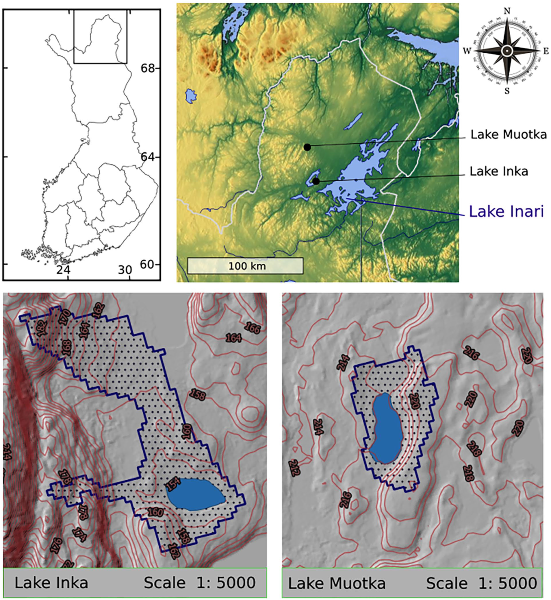
Locations of Lakes Inka and Muotka. Watershed area and topography were calculated from DEM using the QGIS (version 3.16.14, accessed on www.qgis.org). The DEM used was based on open-source raster data (resolution = 10 × 10 m) obtained from the National Land Survey of Finland (https://www.maanmittauslaitos.fi/en/maps-and-spatial-data/expert-users/product-descriptions/elevation-model-10-m).
The study area is underlain by metamorphic bedrock, mostly granite and gneiss (Kähkönen, 1996; Makkonen et al., 2017; Pulkkinen and Rissanen, 1997). Common rock types include garnet cordierite-rich paragneiss, quartz-feldspar gneiss, quartz-diorite gneiss and hypersthene amphibolite (Nironen et al., 2016; Pulkkinen and Rissanen, 1997). The bedrock is overlain by Quaternary glacial deposits, primarily gravel and sand till (Kähkönen, 1996). Chemical elements in surface deposits are mainly silicon (Si), aluminium (Al), iron (Fe), magnesium (Mg), calcium (Ca), potassium (K), sodium (Na), titanium (Ti), phosphorus (P), and manganese (Mn) (Pulkkinen, 2004). Other elements are present at lower concentrations, such as zinc (Zn), nickel (Ni), copper (Cu), cobalt (Co) and lead (Pb) (Pulkkinen, 2004). Leaching of nutrients from decomposed organic matter led to the formation of nutrient poor and acidic podzols. The soil organic layer includes numerous exchangeable ions (K, Ca, Mn, Fe, S, Al, Na, Mg and P) (Äyräs and Kashulina, 2000; Reimann et al., 2000). The uppermost organic layer is strongly influenced by precipitation, atmospheric influx and marine aerosol inputs and has an important capacity to accumulate pollutants (Ni, Cu, S, Fe and Pb) (Äyräs and Kashulina, 2000; Reimann et al., 2000).
The geology, geography and topography of the region influence the distribution of vegetation along a subalpine/subarctic gradient. Lower latitudes/elevations are characterized by coniferous forests dominated by Scots pine mixed with Norway spruce. Transitional mixed forests are found at mid-latitudes/elevations, and birch woodlands at higher latitudes/elevations (Kuuluvainen et al., 2017; Lacand et al., 2023). We sampled two boreal lakes surrounded by pine forests with some birch also present (Figures 1 and 2; Table 1). The understory vegetation around Lake Inka (unofficial name) is mainly dominated by dwarf shrubs (Betula pubescens, Calluna vulgaris, Vaccinium vitis-idaea, Vaccinium myrtillus, and Empetrum hermaphroditum), and the ground layer is mainly composed of mosses and lichens (Pleurozium schreberi, Cladonia arbuscula, and Cladonia rangiferina). The average thickness of the humus layer is 12 cm. At Lake Muotka (unofficial name) the understory vegetation is dominated by dwarf shrubs (Betula nana, Empetrum nigrum, Rubus chamaemorus, and Vaccinium uliginosum). Mosses and lichens (Pleurozium schreberi, Cladonia arbuscula, and Cladonia rangiferina) compose the ground layer. The average thickness of the humus layer is 7 cm.
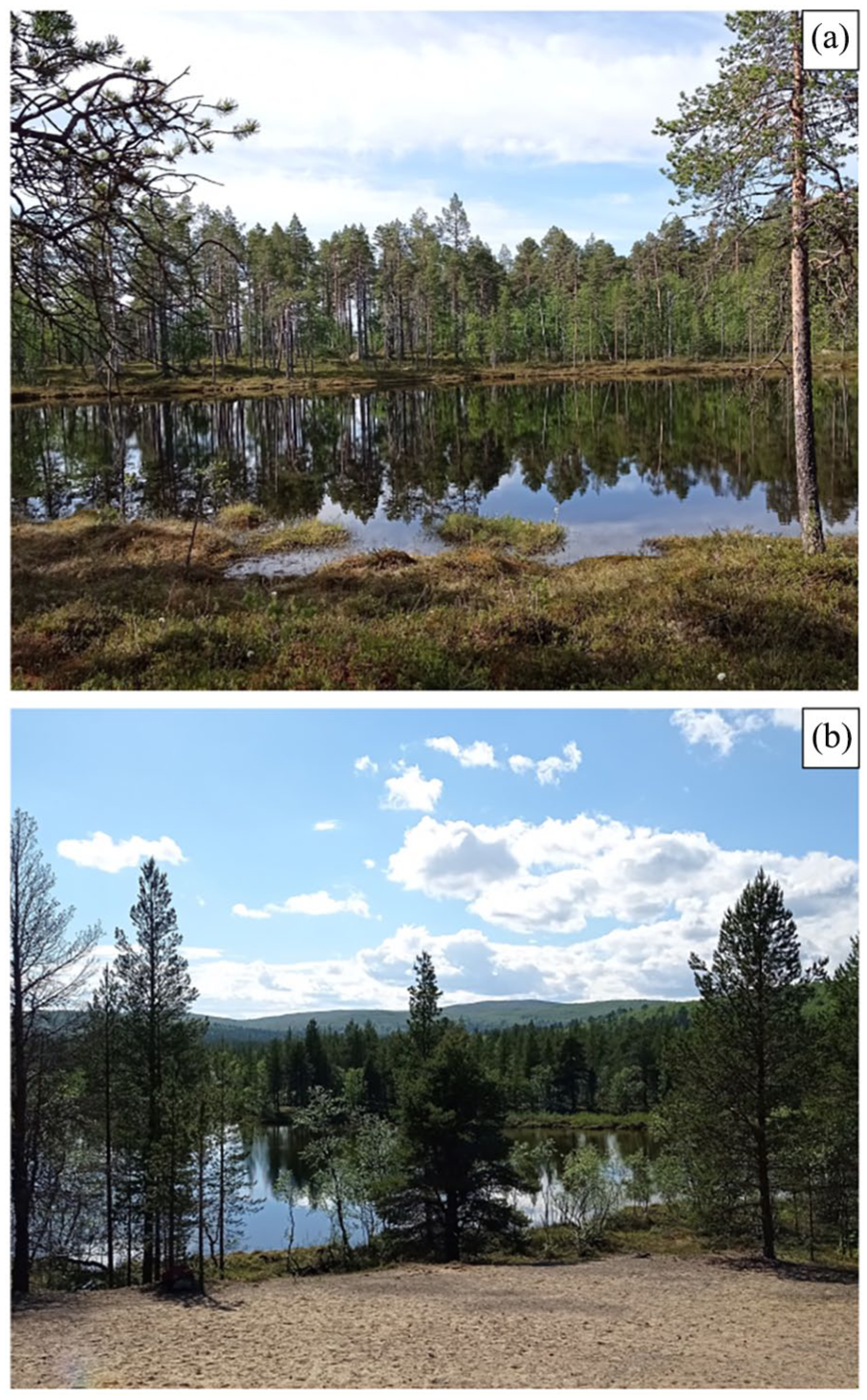
(a) Pinus sylvestris on the shore of Lake Inka. (b) Pinus sylvestris and Betula pubescens on the shore of Lake Muotka, with sand in the foreground.
Characteristics of Lakes Inka and Muotka and their catchments.
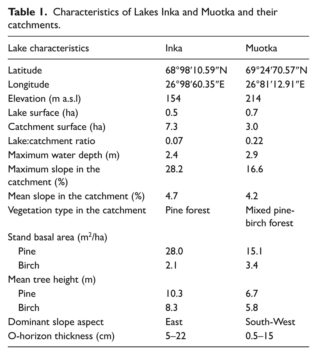
The two sampled lakes are small, exclusively supplied by rainfall and runoff, which ensures sediment inputs are local, with sufficient water depth to avoid sediment mixing in spring and fall, and without rocks at the bottom (which would have prevented sediment coring; Figure 1). Sedimentation rates were sufficient at both lakes to allow for charcoal, geophysical and geochemical analyses. Moreover, considering their depth and morphometry, the sampled lakes are likely meromictic, and no evidence of major geomorphic processes (e.g. landslides) was noted in their watersheds. The following minor differences were noted between the two lake catchments. The Lake Inka catchment has irregular contours characterized by two valleys converging towards the lake (V-shaped morphology) and a 32 m height difference between lake level and the highest point in the catchment (Figures 1 and 2a; Table 1). The Lake Muotka catchment has regular contours, is much smaller than that of Lake Inka and its shoreline is surrounded by glacial deposits of sand and gravel (Figures 1 and 2b; Table 1).
Sediment sequences from Lakes Inka and Muotka were extracted in 2021 with a Russian corer (diameter = 8 cm) at the deepest point of each lake. The sediments were wrapped in plastic and stored in PVC tubes. Samples were maintained in cold conditions (4°C) until analyses. The top layers of sediment below the water-sediment interface (13 cm for Lake Inka and 23 cm for Lake Muotka) were too liquid for geophysical and geochemical analyses, and were not included in this study. For both lakes, a master core was constructed from three overlapping sections, two 1 m-long sections and one 0.5-m-long section (total core length was 1.78 m for Lake Muotka and 2.12 m for Lake Inka). The sections within a master core were aligned based on radiocarbon dates, as well as on geophysical signature (magnetic susceptibility and colorimetry).
Age-depth models
An age-depth model was constructed for each lake, enabling to obtain sedimentation rate values necessary for analysing the different proxies (charcoal, magnetic susceptibility and x-ray fluorescence).
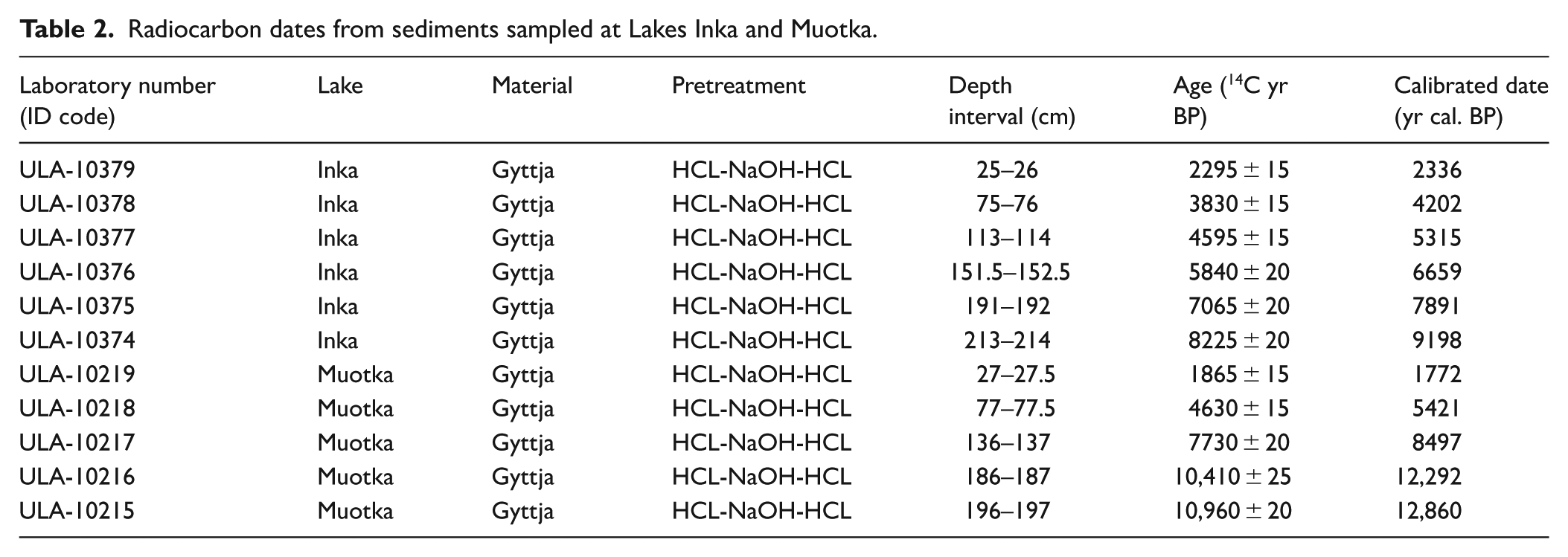
Radiocarbon dating by accelerator mass spectrometry was performed on bulk gyttja due to the absence of plant macro-remains in the sediments (Table 2), which is common occurrence in northern environments (Strunk et al., 2020). Combining 10 cm of sediments would have been necessary to obtain enough macro-remains for dating, which would have considerably reduced precision. Bulk sediment dates might be overestimated due to the presence of reworked land-derived old carbon (Björck et al., 1998; Grimm et al., 2009). However, this effect is limited to 0–500 years in watersheds with widespread plant cover and without carbonate deposits such as those studied here (Björck et al., 1998; Ojala et al., 2019; Strunk et al., 2020). A previous study that compared radiocarbon (14C), cosmogenic (10Be), and luminescence dating of lake sediments in northern Fennoscandia found that the margin of error was the same for all three methods, indicating that if there is a reservoir effect on 14C dates it is minimal (Stroeven et al., 2016). Moreover, because the present study compares events identified with charcoal, magnetic susceptibility, and geochemical analyses within a given chronology (see below), potential dating uncertainties are consistent across proxies and therefore do not affect the results. While between-site comparisons might be affected by different dating uncertainties, these limitations do not compromise interpretations at the millennial timescale.
Radiocarbon dates from sediments sampled at Lakes Inka and Muotka.
The age-depth models were developed using the ‘Bachron’ R package v.4.0.3 based on Bayesian statistical methods (Parnell et al., 2008; R Core Team, 2021) and dates were calibrated with the IntCal20 database (Reimer et al., 2020). Ages were interpolated at contiguous 0.5 cm depth intervals and all dates are expressed in calibrated years before present (cal yr BP).
Charcoal extraction
Macroscopic charcoal particles (>160 µm) were extracted, counted and measured at 0.5 cm continuous intervals in both cores. Samples were prepared by submerging 1 cm3 of sediment into a solution of 5% sodium hexametaphosphate (Na6O18P6), 5% potassium hydroxide (KOH) and 10% sodium hypochlorite (NaClO) smoothly shaken for 24 h to facilitate deflocculation and bleaching of non-charred organic matter. Samples were then sifted using a 160 µm sieve, and macroscopic charcoal particles were manually sorted and photographed under a 20 × stereo microscope equipped with a digital camera. Charcoal particles were counted and measured with the WinSEEDLE image analysis software (WinSEEDLE, 2016). Raw charcoal data (sum of area) were extracted from WinSEEDLE for statistical analyses.
Geophysical and geochemical measurements
The sediment cores were photographed and magnetic susceptibility was measured at 5 mm continuous intervals with a GEOTEK Multi Sensor Core Logger at the Chrono-environment Laboratory (CNRS – Université de Bourgogne Franche-Comté).
The relative contents of major elements were analysed by X-Ray Fluorescence (XRF) at 5 mm continuous intervals on the surface of the sediment cores using an Avaatech Core Scanner at the EDYTEM Laboratory (CNRS-Université Savoie Mont-Blanc). The geochemical data were obtained with two different settings. The first run was performed at 10 kV at 0.175 mA for 10 s to detect lightweight elements (Al, Ca, K, Mg, Na, P, Ti, S and Si), and the second run was performed at 30 kV at 0.2 mA for 15 s to detect heavyweight elements (Br, Cu, Fe, Mn, Ni, Pb, Rb, Sr, Zn and Zr; Richter et al., 2006). Three replicates were measured every 10 cm to estimate the standard deviation. The XRF results are expressed hereafter as element intensities, expressed in counts per second (cps).
Fire and erosion events
Fire histories were reconstructed using the CharAnalysis 1.1 software, following Higuera’s (2009) method (see https://github.com/phiguera/CharAnalysis). Total charcoal concentration (mm²·cm−3) was converted into charcoal accumulation rate (hereafter CHAR, mm²·cm−2·year−1) using the sediment accumulation rates determined by the age-depth models. To remove bias induced by variations in sedimentation rates and to compare fire histories between sites, individual CHAR series (CHARint) were interpolated using the median time resolution (17 years for Lake Inka and 33 years for Lake Muotka). The CHARint series were then filtered by removing low-frequency signals corresponding to variations in charcoal production and sedimentation processes using a robust loess with various (500- to 1000-year) time window widths (CHAR background; hereafter Cbackground), to obtain residual high frequency series (CHAR peak; hereafter Cpeak). Following Brossier et al. (2014), the signal-to-noise index was used to evaluate the effectiveness of the discrimination between fires.
Cpeak series (Cint-Cbackground) were decomposed into two sub-populations using a Gaussian mixture model according to a locally defined threshold: CHARnoise (hereafter Cnoise), representing variability due to sediment sampling and naturally occurring noise, and CHARfire (hereafter Cfire), representing significant charcoal peaks. To determine if the two populations were from the same distribution or not, a goodness-of-fit test was used. We used the 99.9th percentiles of the Cnoise distribution as a threshold. Each Cpeak that exceeded the threshold was considered a fire event having occurred within one kilometre of the lake (Higuera, 2009).
Given the small sizes of the watersheds of Lakes Inka and Muotka (i.e. 7.3 and 2.4 ha respectively; Table 1), some charcoal peaks likely reflected charcoal deposition from events having occurred outside the drainage basins. To identify fires that occurred within the watershed, we used the charcoal size distribution (CSD) method (Asselin and Payette, 2005). The geometric mean diameter of charcoal particles was estimated by calculating the square root of particle surface area as suggested by Clark and Hussey (1996). Then, particles were classified into five evenly spaced size classes ranging from −0.9 to 0.1 log mm and a linear regression was calculated from the distribution of the proportion of charcoal particles within each size class. The two criteria used to determine if a fire occurred within a catchment were the regression slope (under the −1.77 threshold) and the presence of at least one large charcoal particle (>−0.3 log mm2; i.e. > 0.252 mm²) (Oris et al., 2014; Vogel et al., 2023).
We looked for erosion events coinciding with catchment fire events. Magnetic susceptibility was used as an indicator of mineral input and erosion of mineral soil horizons. Following Dunnette et al. (2014) and Leys et al. (2016), magnetic susceptibility peaks were identified using the same method as charcoal peaks, with the CharAnalysis 1.1 software. Then, to test for the simultaneity of fire and erosion events, we used event coincidence analysis (ECA) conducted with the ‘CoinCalc’ R package (Siegmund et al., 2017). Considering the median resolution (17 years for Lake Inka and 33 years for Lake Muotka), we looked for coincidences within the 34 years (i.e. two samples) before and after a catchment fire event for Lake Inka and 66 years (i.e. two samples) for Lake Muotka. We considered both the sediment samples before and after a catchment fire for the ECA, as mineral particles can be slightly translocated deeper and as there can be a short delay between fire and erosion. All catchment fires identified by the CSD method and coinciding with a magnetic susceptibility peak were considered high-severity and, conversely, catchment fires not corresponding with erosion events were considered low-severity.
To ensure the reliability of magnetic susceptibility peak detection, we also used a geochemical proxy of soil erosion. Using the same techniques as for magnetic susceptibility and charcoal records, we identified peaks in the Ca/Fe ratio. In the absence of endogenic marl, the Ca/Fe ratio is interpreted as an indicator of pedogenic input (mainly lithoclastic material from plagioclase) and considered as a chemical weathering proxy (Davies et al., 2015; Koinig et al., 2003). This additional analysis is reported in supporting information (Supplemental Figures S4–S7, available online).
Statistical analyses of geochemical signals
To evaluate the overall effect of high/low severity catchment fires on soil geochemistry, we used X-ray fluorescence (XRF) to measure 19 geochemical elements (Al, Br, Ca, Cu, Fe, K, Mg, Mn, Na, Ni, P, Pb, Rb, S, Si, Sr, Ti, Zn and Zr) in the lake sediments. We then used superposed epoch analysis (SEA) to quantify the average response to multiple events in a time series. Before conducting the SEA, the XRF series were interpolated to the median sample resolution (17 years for Lake Inka and 33 years for Lake Muotka) and the residual series were obtained by removing low-frequency signals, following Dunnette et al.’s (2014) method. Then, the SEA was performed on samples where catchment fires were detected, as well as the two pre-fire and post-fire samples (representing 34 and 66 years before/after fire at Lakes Inka and Muotka, respectively). The statistical significance of the mean series response to high severity fire events was tested using the Monte Carlo randomization method. The 0.5th, 2.5th, 97.5th, and 99.5th percentiles were extracted from the 5000 random composites to construct 95% and 99% confidence intervals. The superposed epoch analysis was conducted on both high and low severity catchment fire events to compare their respective effects on soil geochemistry. The analyses were conducted using the ‘dplR’ R package (Bunn, 2008).
Results
Age-depth models
The oldest basal sediments were dated around 9200 cal yr BP at Lake Inka and around 12,800 cal yr BP at Lake Muotka (Table 2), which means that sediment accumulation started shortly after deglaciation at Lake Muotka and somewhat later at lake Inka (Ojala et al., 2019; Stroeven et al., 2016). According to the Bayesian age-depth models, the mean sedimentation rate was 0.0267 cm·yr−1 for Lake Inka, varying between 0.008 and 0.05 cm·yr−1. For Lake Muotka, the sedimentation rate varied between 0.006 and 0.03 cm·yr−1, with a mean of 0.0157 cm·yr−1. The median sample resolution was 33 yr·0.5 cm−1 for Lake Muotka (between 17 and 77 yr·0.5 cm−1) and 17 yr·0.5 cm−1 (comprised between 10 and 57 yr·0.5 cm−1) for Lake Inka. Both age-depth models are rather linear with no anomalous sedimentation patterns (see Supplemental Figure S1, available online).
Catchment fire histories
At Lake Inka, 39 fire events were detected in the sedimentary sequence using CharAnalysis (Figure 3). The maximum Cint (0.044 mm².cm−2.yr−1) was recorded at 6333 cal yr BP (Figure 3a) and the highest peaks were mainly recorded between 8237 and 4344 cal yr BP. Among the 39 fire events detected, only 10 were identified as catchment fire events by the CSD method (Figure 3b). All catchment fire events were recorded between 8424 and 5619 cal yr BP.
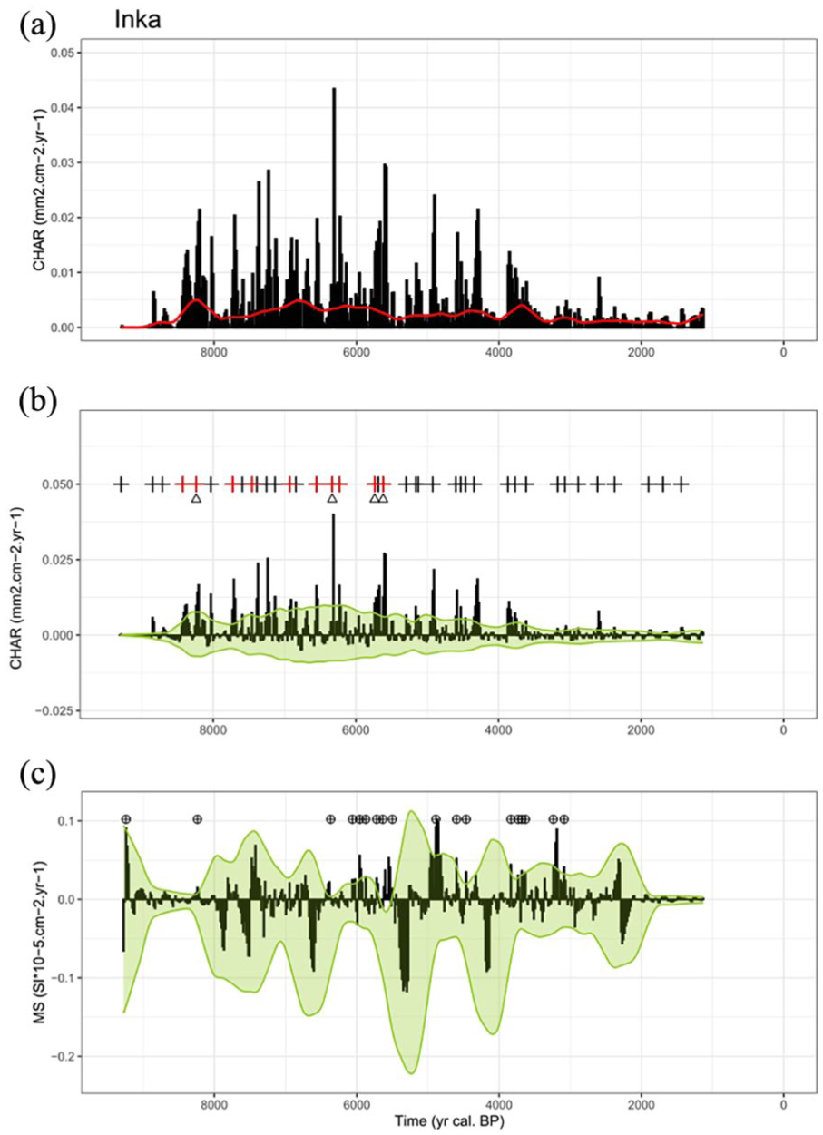
CharAnalysis outputs for Lake Inka. (a) Interpolated charcoal accumulation rate (Cint, black bars) and background trend (Cbackground, red line). (b) Charcoal peaks (Cpeak, black bars) identified by removing Cbackground from Cint. Threshold (green line) used to separate peaks from noise (Cnoise). Black ‘+’ symbols indicate charcoal peaks interpreted as regional fire events (Cfire). Red ‘+’ symbols indicate catchment fire events detected with the CSD method. Triangles indicate catchment fire events coinciding with magnetic susceptibility (MS) peaks interpreted as high-severity catchment fire events. (c) MS peaks (MSpeak, black bars) identified by removing MSbackground from MSint (not shown). Threshold (green line) used to separate peaks from noise (MSnoise). Black circled ‘+’ symbols indicate MS peaks interpreted as erosion events (MSevent).
At Lake Muotka, 41 fire events were detected in the sedimentary sequence using CharAnalysis (Figure 4). The maximum Cint (0.061 mm².cm−2.yr−1) was recorded at 11,705 cal yr BP (Figure 4a). A total of 22 catchment fires were identified by the CSD method throughout the sequence and they occurred between 12,497 and 1607 cal yr BP (Figure 4b).
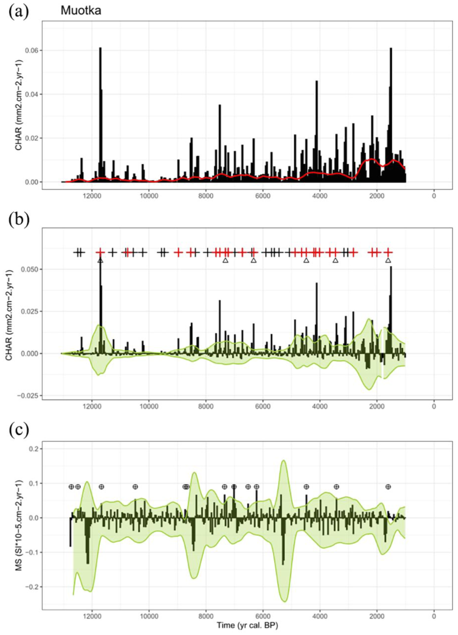
CharAnalysis outputs for Lake Muotka. (a) Interpolated charcoal accumulation rate (Cint, black bars) and background trend (Cbackground, red line). (b) Charcoal peaks (Cpeak, black bars) identified by removing Cbackground from Cint. Threshold (green line) used to separate peaks from noise (Cnoise). Black ‘+’ symbols indicate charcoal peaks interpreted as regional fire events (Cfire). Red ‘+’ symbols indicate catchment fire events detected with the CSD method. Triangles indicate catchment fire events coinciding with magnetic susceptibility (MS) peaks interpreted as high severity catchment fire events. (c) MS peaks (MSpeak, black bars) identified by removing MSbackground from MSint (not shown). Threshold (green line) used to separate peaks from noise (MSnoise). Black circled ‘+’ symbols indicate MS peaks interpreted as erosion events (MSevent).
Fire-erosion coincidence
Magnetic susceptibility detected 18 erosion events at Lake Inka (Figure 3). Magnetic susceptibility peaks were recorded from 9240 to 3086 cal yr BP, with higher frequency between 6367 and 3086 cal yr BP (Figure 3c). Among the 10 catchment fire events detected by the CSD method, four coincide with an erosion event and are therefore considered as high-severity events (Figure 3b; see Supplemental Figure S2, available online). The six other catchment fire events are considered low-severity events (Figure 3b; see Supplemental Figure S2, available online).
At Lake Muotka, magnetic susceptibility detected 13 erosion events (Figure 4). Magnetic susceptibility peaks were recorded all along the sedimentary sequence, with higher frequency between 8868 and 6260 cal yr BP (Figure 4c). Among the 22 catchment fire events detected by the CSD method, six coincide with an erosion event and are therefore considered as high-severity events (Figure 4b; see Supplemental Figure S3, available online). The 16 other catchment fire events are considered low-severity events (Figure 4b; see Supplemental Figure S3, available online).
At Lake Inka, all four of the catchment fire events coinciding with erosion events identified by magnetic susceptibility also corresponded to a peak of the Ca/Fe ratio, also a proxy of erosion (see Supplemental Figures S4 and S6, available online). At Lake Muotka, four of the six catchment fire events coinciding with erosion events identified by magnetic susceptibility also corresponded to a peak of the Ca/Fe ratio (see Supplemental Figures S5 and S7, available online).
Geochemical response to high-severity catchment fires
At Lake Inka, the concentrations of five elements (Al, Ca, K, Ni and Si) were significantly higher in samples where high-severity catchment fire events were detected (Figure 5). No significant change was recorded in the concentrations of the other elements in response to high-severity catchment fire events (see Supplemental Figure S8, available online). In contrast, no significant geochemical response was observed in samples where low-severity catchment fire events were detected (Figure 5; see Supplemental Figure S8, available online).
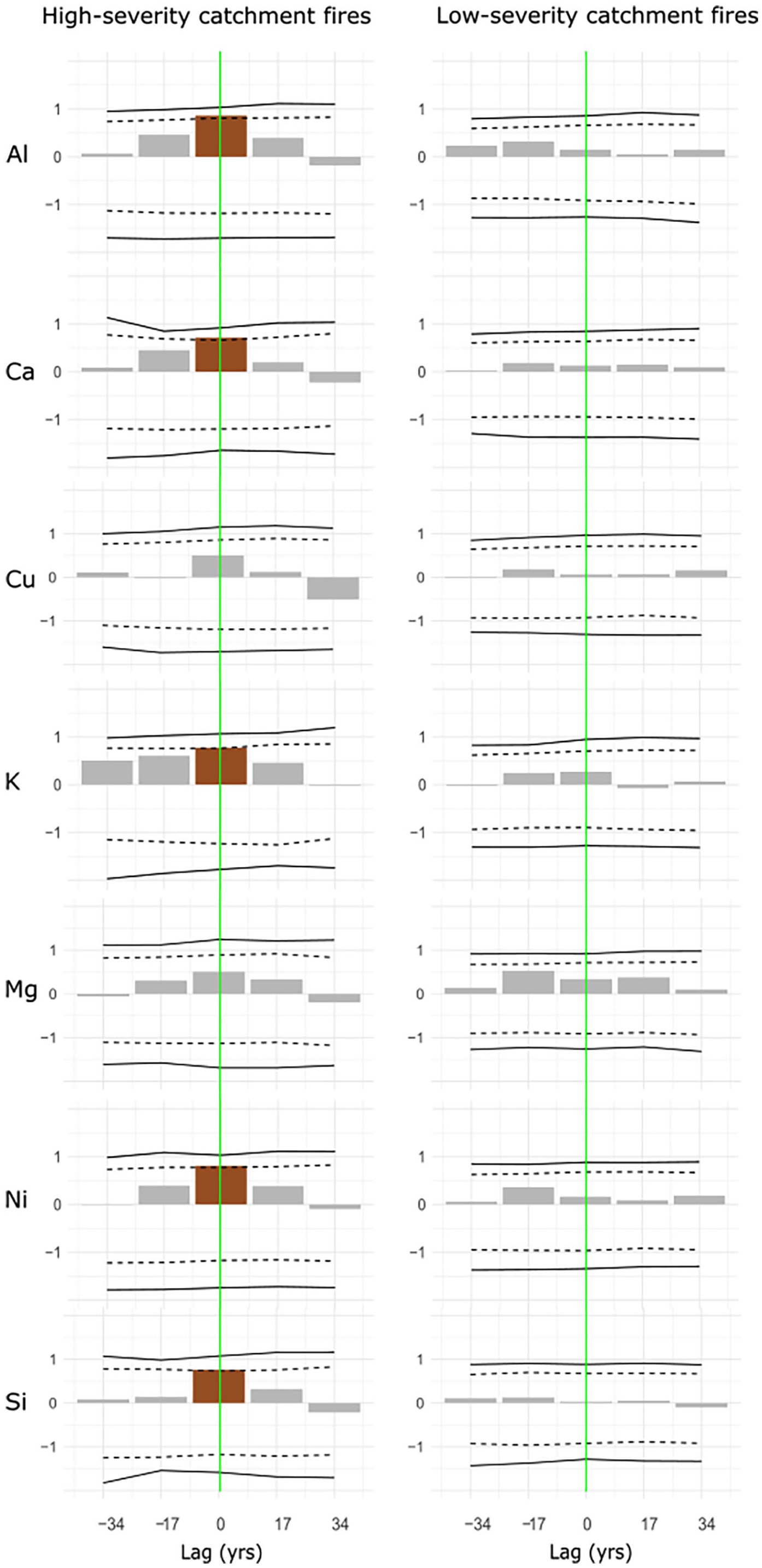
Superposed epoch analysis (SEA) for the four high-severity catchment fires and the six low-severity catchment fires at Lake Inka. Brown bars are significantly positive anomalies from 500 year mean concentrations of Al, Ca, Cu, K, Ni, Mg, Ni and Si. Composite residual response values (y-axis) before and after high-severity catchment fires (vertical solid green line) are shown. The solid and dashed black lines represent Monte Carlo-derived 99% and 95% confidence intervals, respectively.
At Lake Muotka, the concentrations of six elements (Al, Ca, Cu, Mg, Ni and Si) were significantly higher in samples where high-severity catchment fire events were detected (Figure 6). Four of the responsive elements were the same as at Lake Inka (Al, Ca, Ni and Si). No significant change was recorded in the concentrations of the other elements in response to high-severity catchment fire events (Figure 6; see Supplemental FigureS9, available online). Therefore, no significant geochemical response was observed in samples where low-severity catchment fire events were detected (Figure 6; see Supplemental Figure S9, available online).
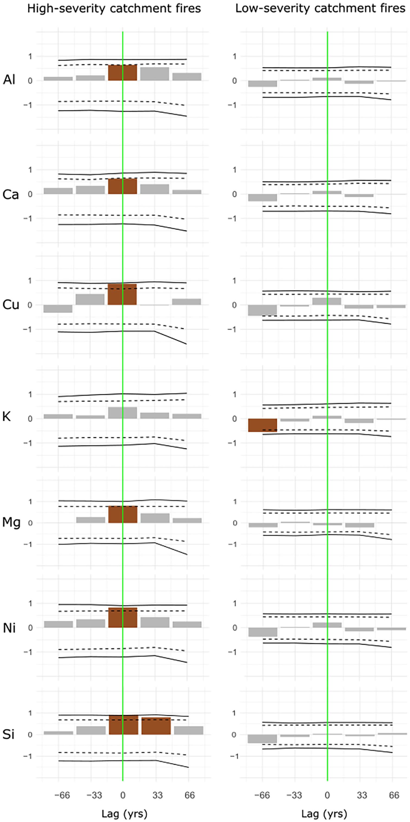
Superposed epoch analysis (SEA) for the six high-severity catchment fires and the 16 low-severity catchment fires at Lake Muotka. Brown bars are significantly positive anomalies from 500 year mean concentrations of Al, Ca, Cu, K, Ni, Mg, Ni and Si. Composite residual response values (y-axis) before and after high-severity catchment fires (vertical solid green line) are shown. The solid and dashed black lines represent Monte Carlo-derived 99% and 95% confidence intervals, respectively.
Discussion
Fire-induced soil erosion
Some of the fire events that occurred within the catchments of Lakes Inka and Muotka. coincided with peaks in magnetic susceptibility and the Ca/Fe ratio, both proxies of mineral soil erosion (Carcaillet et al., 2006; Davies et al., 2015; Dunnette et al., 2014; Leys et al., 2016). Fire events inducing soil erosion by water and wind are considered high-severity fires, as they destroy the organic soil layer and expose the mineral layer (Carcaillet et al., 2006; Certini, 2005; Kelly et al., 2023; Seppälä, 1981, 1995). Mineral soil exposure increases deflation, surface runoff, deep percolation and chemical weathering, all processes leading to terrestrial exports to lake ecosystems (Bastianelli, 2018; Bixby et al., 2015; Certini, 2005). Moreover, high-severity fires induce soil compaction due to the migration of pyrogenic organic material. This compaction modifies infiltration capacity, structural stability, porosity and increases surface runoff and mass wasting from forest soil to aquatic systems (Agbeshie et al., 2022; Ayoubi et al., 2021; Certini, 2005; Chebykina et al., 2024; Dymov et al., 2022; Maynard et al., 2014; Pellegrini et al., 2022). Consequently, increased water turbidity, hypoxic conditions and light limitation may lead to declines in primary production and aquatic biodiversity (Bixby et al., 2015). Because soils recover slowly in low-productivity environments, fire-induced soil disturbances may persist over long timescales (Matthews and Seppälä, 2014).
In contrast to high-severity fires, low-severity fires consume only part of the organic soil horizons and vegetation cover, produce no detectable effect on soil erosion, therefore resulting in fewer alterations to post-fire recovery processes (Agbeshie et al., 2022; Bixby et al., 2015; Miesel et al., 2015; Rogers et al., 2015). The predominance of low-severity fire events compared to high-severity fire events in both sites aligns with the historical boreal forest fire regime in landscapes dominated by Pinus species (Aakala, 2018; Lacand et al., 2023; Remy et al., 2023; Wallenius et al., 2010).
Some erosion events identified by magnetic susceptibility and Ca/Fe peaks did not coincide with catchment fire events. Major flooding events have previously been recorded in the boreal zone (e.g. Ali et al., 2008; Asselin and Payette, 2006; Borgstrom et al., 1999; Jonasson and Nyberg, 1999), which led to massive inputs of sediments (organic and/or mineral) into lakes (e.g. Ali et al., 2008; Augustsson et al., 2013; Bonk et al., 2016). Such flooding event might closely follow a severe fire, particularly when lightning-initiated fire events coincide with periods of intense thunderstorm activity (Matthews and Seppälä, 2015). The compounded disturbances would then cause even more severe and long-lasting effects on the structure and chemical composition of soils, in addition to inducing changes in successional trajectories (Bastianelli, 2018). Short-term localized dune exposure can also induce sediment inputs into lakes through aeolian processes, especially during drought periods or temporary declines in vegetation cover caused by windthrow or insect outbreaks (Kotilainen, 2004; Matthews and Seppälä, 2014, 2015). Many erosion events recorded in the sediments of Lakes Inka and Muotka that did not coincide with local fire events occurred during the warm and dry Mid-Holocene, a period marked by drought events and decline in ground water table in northern Finland (Sarmaja-Korjonen et al., 2006). Hence, while high-severity fire events can be defined by their capacity to induce soil erosion, soil erosion proxies cannot be used as proxies of fire occurrence, and must be used in combination with charcoal analysis.
Effects of high-severity catchment fires on soil geochemistry
Our results show a significant increase in the concentrations of four elements (Al, Ca, Ni and Si), concomitant with high-severity fire events identified by magnetic susceptibility peaks in both studied lakes. Three other elements showed significant increases, either in Lake Inka (K) or Lake Muotka (Cu and Mg). All of the elements which showed increased concentrations following high-severity catchment fires are part of the crystal structure of bedrock minerals common in Fennoscandia (Kylander et al., 2018; Makkonen et al., 2017; Pulkkinen and Rissanen, 1997). While some elements (Ca and Si) can be of both autochthonous (from within the lake) and allochthonous (from outside) origin, such a significant increase would imply external supply (Davies et al., 2015; Dunnette et al., 2014). A sudden external nutrient supply to aquatic ecosystems may create unstable environmental conditions that favour opportunistic, short-lived, and fast-colonizing species at the expense of indigenous species, thereby reducing aquatic biodiversity (Harris et al., 2015).
Our results support previous studies having shown that common essential elements for plant growth (Ca, Cu, K, Mg), mainly contained in the upper layers of podzols, are exported from the catchment ecosystem after high-severity fire events (Bastianelli, 2018; Certini, 2005; Kylander et al., 2018; Leys et al., 2016). High-severity catchment fires can even affect deeper soil horizons where Al-Fe complexes accumulate (Bastianelli, 2018; Yuan et al., 1998). Indeed, aluminium (Al) concentration increased in the sediments of the studied lakes following high-severity fires, but not iron (Fe) concentration. Iron quickly precipitates as oxyhydroxide under acid conditions, unlike aluminium which remains soluble (Al-hydroxide) and can easily form a complex with organic matter or silicon (Si), facilitating transfer to lake systems (Bastianelli et al., 2017; Yuan et al., 1998). Denaturation of deeper soil horizons may alter water infiltration, soil moisture and water repellence, delaying vegetation recovery and prolonging landscape openness (Bastianelli et al., 2017; Kelly et al., 2023).
The increase in Cu and Ni in lake sediments after high-severity catchment fires suggests that these metals are naturally abundant in the soils of the study area (Abraham et al., 2017). In north-eastern Finland, heavy metals are contained in bedrock rich in platinum-group elements (including platinum, palladium, rhodium, ruthenium, iridium, and osmium), copper and nickel (Kojonen et al., 2005; Konnunaho et al., 2015). Recently, soils of northern Finland have also been contaminated by heavy metal emissions from Cu-Ni smelters (Derome et al., 1998; Nieminen, 2005). Heavy-metal contamination of aquatic ecosystems can lead to the decline of some species, sometimes in favour of more resistant invasive species (Kelly et al., 2023). Such a species shift can disrupt trophic networks and, in some cases, render habitats unsuitable for the recolonization of native species, contributing to the persistence of high-severity fire effects (Kelly et al., 2023).
Conclusion
Our combination of charcoal analysis with magnetic susceptibility and geochemical analyses revealed that high-severity fire events in northern Finland can lead to the leaching of Al, Ca, N, Si and heavy metals into aquatic ecosystems, while the effects of low-severity fires on leaching are negligible. Soil degradation following high-severity fires can have long-term effects on vegetation structure and composition (Asselin et al., 2006; Bastianelli et al., 2017; Johnstone and Chapin, 2006; Kelly et al., 2023; Matthews and Seppälä, 2014). Moreover, sudden terrestrial inputs into lakes following high-severity fires may generate unstable, hypoxic conditions and heavy metal contamination (Abraham et al., 2017; Alexakis, 2020; Manzetti, 2020; Moilanen et al., 2021; Rust et al., 2022) detrimental to native aquatic species but favourable to opportunistic or invasive species (Harris et al., 2015; Kelly et al., 2023). Such environmental disruptions will likely become more frequent as wildfire activity is expected to increase in boreal forests due to climate change.
Supplemental Material
sj-docx-1-hol-10.1177_09596836251378013 – Supplemental material for Wildfire-induced soil erosion in northern Finland watersheds
Supplemental material, sj-docx-1-hol-10.1177_09596836251378013 for Wildfire-induced soil erosion in northern Finland watersheds by Marion Lacand, Hugo Asselin, Tuomas Aakala, Damien Rius, Marianne Vogel, Laure Paradis and Adam A Ali in The Holocene
Footnotes
Acknowledgements
We would like to express our appreciation to Anne-Lise Develle for help with geochemical analysis and to Sandrine Canal for help with macrocharcoal sample preparation. We would also like to thank Benoît Brossier and Heikki Seppä for their assistance with fieldwork.
Author contributions
Funding
The authors disclosed receipt of the following financial support for the research, authorship, and/or publication of this article: Marion Lacand received scholarships from the J.A. DeSève Foundation and UQAT Foundation.
Data availability statement
Supplemental material
Supplemental material for this article is available online.
References
Supplementary Material
Please find the following supplemental material available below.
For Open Access articles published under a Creative Commons License, all supplemental material carries the same license as the article it is associated with.
For non-Open Access articles published, all supplemental material carries a non-exclusive license, and permission requests for re-use of supplemental material or any part of supplemental material shall be sent directly to the copyright owner as specified in the copyright notice associated with the article.