
Abstract
Fire has influenced age stands and forest composition in boreal ecosystems over millennia. The Cape Breton Highlands National Park in northern Nova Scotia encompasses a unique mixture of Boreal, Taiga and Acadian ecosystems. A sediment record from Paquette Lake within the park spans the initial development of the lake to the early 20th century and is the first well-dated Holocene record of vegetation and fire history from this region. Vegetation history based on analysis of pollen grains, and fire history based on accumulation of macrocharcoal particles (>125 µm) and identification of charcoal morphotypes, provides information on millennial-scale changes in forest composition and on the frequency and size of local to regional fires. Forest composition follows the inferred fire regime zones over the Holocene, supporting the strong interconnections between climate, vegetation, and fire. The early Holocene fire regime (ca. 11,000–7000 cal yr BP) was characterized by large and frequent fires under warming conditions and high fuel availability when Picea and Pinus were most abundant. The mid-Holocene (ca. 7000–5000 cal yr BP) was characterized by a lower frequency of smaller fires than in the early Holocene and some large local fires when Quercus and Tsuga reached their highest abundances. The lowest fire frequency over the Holocene occurred between ~5000 and 2000 cal yr BP when Fagus increased, and Pinus and Quercus declined. The early 20th century composition of forest and fire regime in Paquette Lake was established ca. 2000 cal yr BP. This period had a higher fire frequency and larger local fires than between ~5000 and 2000 cal yr BP but a lower magnitude in comparison to the early Holocene. Records of ecosystem change over millennia provide critical baselines for modeling future scenarios of vegetation and climate change.
Introduction
Fire creates mosaics of different age stands and forest composition in eastern Canadian boreal ecosystems (Erni et al., 2016; Gennaretti et al., 2014). In northern Cape Breton, Nova Scotia, historical evidence indicates that fire has influenced the Boreal and Taiga ecosystems and may be important to the formation and maintenance of the taiga landscape in this region (Bridgland et al., 1995, 2011). Additional influences on the landscape include climate change, habitat and species loss, and invasive species that are expected to continue to impact the region (Parks Canada, 2010). Climate change can heighten impacts from fire and other natural disturbances, altering the composition and functional processes within forest ecosystems (Dale et al., 2001). Fire, windstorms (particularly hurricanes), and insect outbreaks (predominantly spruce budworm) are some of the dominant determinants of the natural disturbance regime of Nova Scotian forests (Taylor et al., 2020). Interactions between disturbances can lead to cumulative impacts. For instance, over browsing by a large population of moose following a spruce budworm outbreak in the 1970s continues to impair forest regeneration (Parks Canada, 2022). Fires are also more likely after a large insect outbreak or when mass blow downs occur during hurricanes, both of which provide high fuel availability (Dale et al., 2001; Taylor et al., 2020).
The purpose of this paper is to better understand fire and vegetation history to help manage biodiversity, vegetation communities, connectivity, and potential climate change adaptation and mitigation within the Cape Breton Highlands National Park. The park encompasses a unique mixture of Boreal, Taiga and Acadian ecosystems, but limited data exist of ecosystem changes at a Holocene scale in this region. Regional fire regimes can be estimated through the analysis of charcoal accumulation in lake sediments as a proxy for biomass burned (Carcaillet et al., 2001; Molinari et al., 2018), while vegetation history can be estimated from the analysis of pollen grains preserved in lake sediments (Chevalier et al., 2020). Estimates of the composition of forests and their densities are important as it influences fire regimes, and affects the flammability, fuel load, and susceptibility of the ecosystem to fire (Blarquez et al., 2015; Girardin et al., 2013; Higuera et al., 2009; Lynch et al., 2004b). Climate also influences fire regimes and vegetation ecosystems at multiple temporal and spatial scales, from decades to millennia and stand level from 100s to 1000s of hectares.
Early studies of vegetation changes over the Holocene in Nova Scotia (Green, 1987; Livingstone and Estes, 1967; Livingstone, 1968) identify similar zones of vegetation based on pollen composition, but limited dates make assessments of coherency difficult. Fire history over the Holocene is less well studied and often based on counts of microcharcoal on pollen slides (Green, 1987). Several more recent pollen records have stronger age models but are in central and western Nova Scotia (Lennox et al., 2010; Mott et al., 2009; Neil et al., 2014) and therefore are less applicable to the geographically distinct northern Cape Breton region.
Our study is the first well-dated Holocene record of vegetation and fire history over the past ~12,000 years from northern Cape Breton. The Holocene sedimentary record from Paquette Lake extends from its formation after deglaciation to the early 20th century. Analysis of changes in total accumulation of charcoal enables estimates of fire-return intervals, while differentiation of charcoal morphotypes and size distributions provide evidence to estimate the size and occurrence of local fires (Enache and Cumming, 2006; Higuera et al., 2007). Analysis of pollen assemblages from Paquette Lake provides a history of vegetation changes (Chevalier et al., 2020) from within the Taiga-Boreal habitat. A similar analysis of pollen from Warren Lake, south of Paquette Lake, provides vegetation history in the Acadian region but only over the past ~8200 years, as the early Holocene sedimentary record was not able to be retrieved.
Study site
The Cape Breton Highlands National Park (CBHNP) was established in 1936 and protects ~950 km2 of diverse habitat of Boreal, Taiga and Acadian ecosystems in the northern Cape Breton, Nova Scotia region. The regional maritime climate is largely driven by the Atlantic Ocean and the Gulf of St. Lawrence (Parks Canada, 2010). The CBHNP is located on the traditional lands of the Mi’kmaq and has a long history of cultural and spiritual significance since ~10,000 years ago (Parks Canada, 2010). European colonization in the region began in the early 1500s to mid-1660s (Parks Canada, 2010). Paquette Lake is a shallow (max depth ~2.0 m), small lake (surface area = 5.0 ha), with a drainage area of 20.8 km2 located in the northeastern region of the CBHNP (Figure 1). Warren Lake is deeper (max depth ~31 m) with a larger surface area (90 ha) and a drainage area of 38.4 km2 located in the southeastern region of the CBHNP (Figure 1). Surrounding vegetation cover varies between the two lakes with higher percentage cover of softwoods, wetlands, and barrens in the Paquette Lake watershed and higher percentage cover of hardwoods and mixed woods in the Warren Lake watershed, especially in the areas adjacent to the lakes (Figure 1 and Supplemental Material Figure S1).
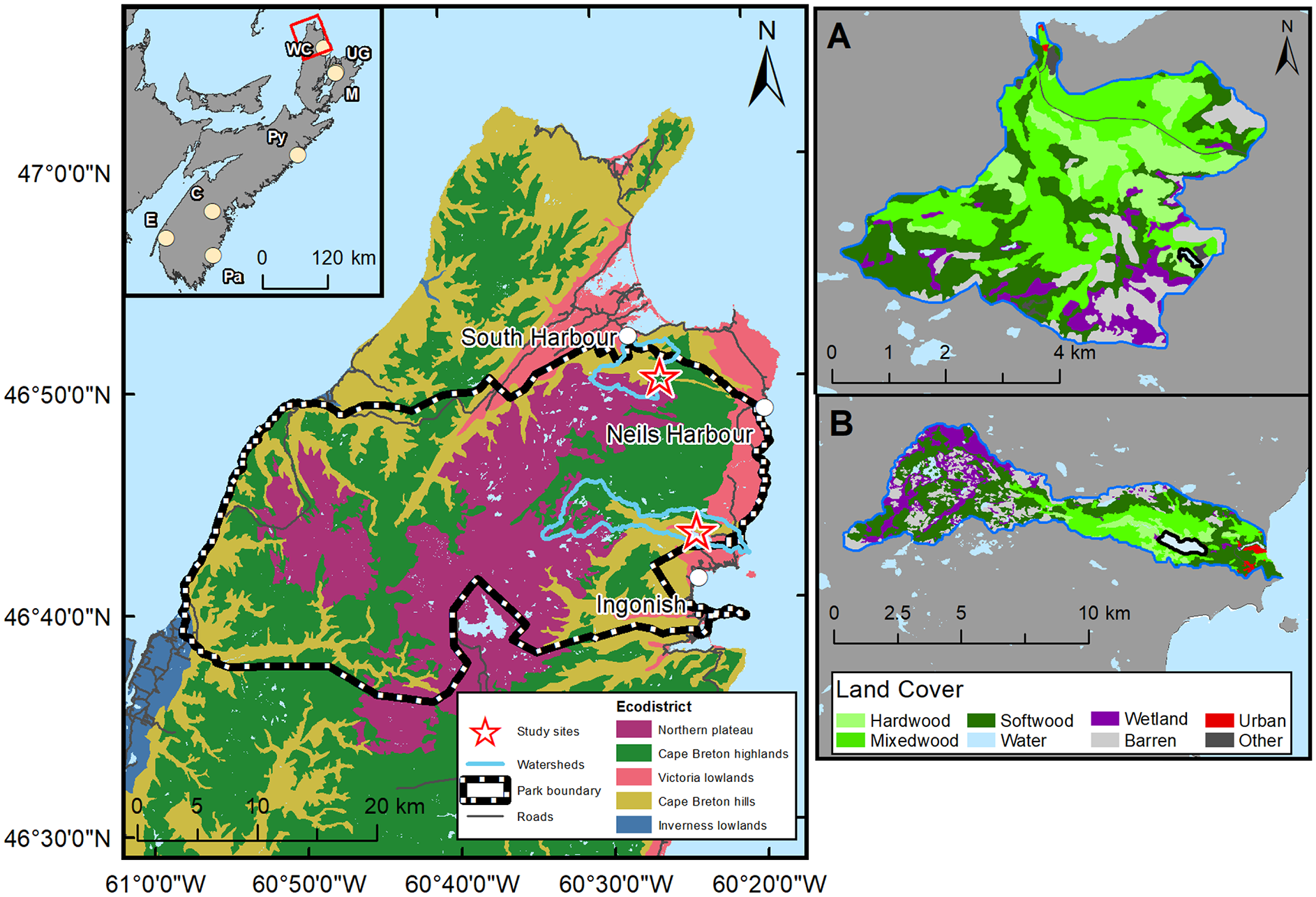
Location of Paquette Lake (northeast) and Warren Lake (southeast) within the Cape Breton Highlands National Park (park boundary). Land classification based on Neily et al. (2017). Northern plateau is representative of taiga vegetation, Cape Breton highlands represent boreal vegetation and Cape Breton hills largely represents Acadian vegetation. The inset identifies the location of research area for this study (red box) and other study sites mentioned in the text (beige solid circles): Everitt Lake (E) Green (1987); Path Lake (Pa) Neil et al. (2014); Canoran Lake (C) Lennox et al. (2010); Pye Lake (Py) Mott et al. (2009); Upper Gillies Lake (UG) and McDougall Lake (M) ~3 km apart, Livingstone (1968); Wreck Cove Lake (WC) Livingstone and Estes (1967). Panels A (Paquette Lake) and B (Warren Lake) provide land cover data for the two watersheds. See Supplemental Figure S1 for details.
Based on the Nova Scotia ecological land classification ecozones of Neily et al. (2017), Paquette Lake is situated in the Northern Plateau (CBHNP-Taiga) and Cape Breton Highlands (CBHNP-Boreal) vegetation regions (Figure 1). The Taiga-Northern Plateau region is characterized by extensive barrens (dry, rocky, upland soils) with lichens (e.g. Cladonia), stunted black spruce (Picea mariana) and balsam fir (Abies balsamea; Parks Canada – CBHNP parks.canada.ca/pn-np/ns/cbreton). The forests of the Boreal-Cape Breton Highlands area are comprised primarily of balsam fir and white birch (Betula papyrifera), with smaller numbers of black and white spruce (Picea mariana & Picea glauca; Parks Canada – CBHNP). Climate in the Northern Plateau region is characterized by long cold winters, short cool summers (average annual temperature is ~6°C) and high precipitation (~1400–1600 mm with ~400 cm of snow; Neily et al., 2017). Warren Lake is situated in the Cape Breton Hills (CBHNP-Acadian) ecological land classification ecozone (Neily et al., 2017). The Acadian forests in northern Cape Breton are comprised largely of balsam fir, sugar maple (Acer saccharum), yellow birch (Betula alleghaniensis), American beech (Fagus grandifoloia) and eastern hemlock (Tsuga canadensis; Parks Canada – CBHNP). Mean annual temperature and precipitation at Ingonish (~2 km east of Warren Lake) are 6.2°C (1951–1999) and 1682 mm (1951–1999), respectively (Adjusted and Homogenized Canadian Climate Data, 2021; Vincent et al., 2012).
Methods
Sedimentary core collection and sectioning
Piston cores were collected from Paquette and Warren lakes in October 2018. A 3.51 m piston core was retrieved from Paquette Lake from the east end of the lake in ~2 m water depth (46° 49′ 56.89″ N, 60° 25′ 50.87″ W). The core was collected in four sections: S1, 0.58 m; S2, 0.96 m; S3, 0.98 m; and S4, 0.99 m. The sediment length in S1 is shorter as it was retrieved to ensure the sediment-water interface was collected. Each section of the core was split in half longitudinally at Queen’s University. One half was sliced into 0.5 cm intervals for charcoal analysis, and the other half was sliced into 1.0 cm intervals for organic matter content, pollen analyses, and carbon dating. At Warren Lake, the piston core was collected from the west end of the lake in ~30 m water depth (46° 42′ 51.26″ N, 60° 23′ 59.42″ W). The core was a total length of 4.86 m and retrieved in six sections: S1, 0.24 m; S2, 0.94 m; S3, 0.9 m; S4, 1.0 m; S5, 0.9 m; and S6, 0.88 m. Each section was sampled as described for Paquette Lake.
Chronology
Subsamples of ~3–4 g wet sediment were sent to LacCore at the University of Minnesota in Minneapolis to isolate and concentrate pollen for radiocarbon dating (Brown et al., 1992). Six pollen samples from Paquette Lake and 10 from Warren Lake were processed at LacCore, and then sent to Lawrence Livermore National Lab (LLNL) in California for accelerator mass spectrometry (AMS) 14C carbon dating (Supplemental Material Table S1). Three macrofossils of terrestrial material (Table S1) retrieved from the Warren Lake piston core were pre-treated (acid-base-acid) before being sent for AMS 14C carbon dating at LLNL.
The 14C dates were calibrated to calendar year Before Present (cal yr BP) and age models were developed (excluding the three macrofossil samples) using the IntCal-13 14C calibration curve and Bayesian statistics using the Bacon package in R (Blaauw and Christen, 2011). Calendar year BP versus depth in core are standardized to present (1950 common era (CE); Wolff, 2007; Supplemental Material Figure S2). Sediments from the tops of C1S1 of both cores were analyzed for 210Pb by gamma analysis as in Schelske et al. (1994) to determine the age (Appleby and Oldfield, 1978; Figure S2).
Organic matter and carbonate analysis
Each piston core section from Paquette and Warren lakes was subsampled for organic matter analyses (~0.5–0.9 g dried sediment) every 4 cm, providing an average resolution of 135 and 70 years, respectively. Percent organic matter (550°C for 4 h) and percent carbonates (950°C for 2 h) was determined using standard loss-on-ignition (LOI) methods (Heiri et al., 2001).
Charcoal sample preparation and analysis
In Paquette Lake, adjacent piston core samples sectioned at 0.5 cm intervals covering the past ~11,000 years were processed for charcoal. The bottom portion of the sediment sequence from Paquette Lake (~12,000–11,000 cal yr BP) was highly inorganic and dominated mostly by clays and thus was not processed for charcoal.
For charcoal analysis, 1 ml (or ~1 g) of wet sediment was placed into labeled beakers. To each beaker, ~20 ml of 10% KOH solution was added, and the sample stirred and covered for 24 h. To oxidize and bleach organic material, ~20 ml of 5% sodium hypochlorite was then added to each sample and left to soak for another 48 h, with samples stirred twice per day. The sediment was gently wet-sieved through a 125 -µm mesh screen and backwashed into a 3-dram vial. A few drops of 70% ethanol were added and then samples were stored at 4°C. For enumeration of charcoal particles, the sample was poured into a petri dish, briefly settled, and each charcoal particle was identified by optical microscopy using a Leica MZ12.5 dissecting microscope at 50× magnification. Digital images of individual charcoal particles were taken, and area and diameter were measured using imaging software.
Enumeration of charcoal morphotypes >125 µm were based on the seven morphotypes outlined in Enache and Cumming (2006) and Moos and Cumming (2012). The representative photos of the B & S types in these two studies varied somewhat and were separated in our study into type B & S Enache and B & S Moos. Each particle of charcoal >125 µm was enumerated and a digital picture was taken to enable calculation of area for each particle. The number of macrocharcoal particles that were >125, 300, 600, and 1000 µm was enumerated for each sample. The few particles >1000 µm were incorporated into the >600 µm.
Charcoal zones were defined by cluster analysis in TILIA (Grimm, 1987) based on (i) charcoal morphotypes and (ii) size distributions (>300 µm, >600 µm, and total counts > 125 µm). The zones based on the morphotypes were used as the main charcoal zones as they are similar to the size distribution zones. The CharAnalysis program version 0.9 (Higuera, 2009) was used to analyze peak magnitude and fire-return intervals (FRI) on the total macrocharcoal counts (>125 µm). The data inputs were 20-yr interpolation, zones at 2100, 5100, and 7100 cal yr BP, lowess smoothing at 200-yr intervals and fire frequency at 500-yr smooth. The signal-to-noise index (SNI) is based on Kelly et al. (2011).
Pollen preparation and enumeration
Pollen analysis followed the method of Bennett and Willis (2001) but without hydrofluoric acid digestion as sediments were highly organic with little siliciclastic content. Exotic Lycopodium clavatum tablets were added to each sample to provide an estimate of the concentration of pollen grains based on their known concentration (each tablet contains 18,407 ± 592 Lycopodium spores). Fossil Lycopodium was distinguished from the spike as primarily L. lucidulum and L. selago with some rare L. obscura. Two tablets were added to each 1-gram wet sediment sample, stirred, and dissolved in 10% hydrochloric acid. The pollen samples were deflocculated in 10% potassium hydroxide, sieved through 10 μm mesh, backwashed, acetolyzed, and mounted onto microscope slides in silicon oil. Samples were chosen based on providing a ~200-year resolution for both lakes. A minimum of 400 pollen grains were counted per sample using a Leica DMRB microscope at 400× magnification except for the four oldest samples where pollen was scarce, likely due to high amounts of clay (mean number of pollen grains counted for these samples was 56). Pollen grains and spores were identified to the genus level when possible, using palynological references for northeast North America (Bassett et al., 1978; McAndrews et al., 1973). Cluster analyses were performed on both the percentages and concentrations of the pollen grains in the program TILIA using a square-root transformation (Edward’s & Cavalli-Sforza’s chord distance; Grimm, 1987). As the cluster analyses were similar between the two, the defined vegetation zones are based on the percentages of pollen grains.
Additional counts were undertaken to estimate the composition of Pinus into the two subgenera Strobus (P. strobus – haploxylon) and Pinus (P. banksiana, P. resinosa – diploxylon), as most Pinus pollen grains in the initial counts were either fragmented or not in the right orientation to differentiate. Concentrated pollen slides were prepared and at least 50 whole pollen grains of Pinus were counted into the two subgenera, except for a few samples where Pinus was not abundant. The secondary Pinus subgenera counts were carried out on every other sample analyzed for the full pollen assemblage, resulting in a resolution of ~400 years between samples. These ratios were used to estimate the composition of the two subgenera of Pinus in the original counts.
Results
Chronology
Based on the calibrated ages, the 3.5 m sediment record retrieved from Paquette Lake spans ~12,000 calendar years and the 4.8 m sediment record from Warren Lake spans ~8200 calendar years. The three dates based on macrofossils in Warren Lake corresponded closely to those based on pollen dates from the same sediment intervals. The close correspondence provides support for the use of pollen for 14C dating in other sections of the cores from Paquette and Warren lakes (Supplemental Material Table S1 and Figure S2). Furthermore, the macrofossil dates of various terrestrial material were slightly younger than the pollen indicating that influence of old carbon is limited.
In Paquette Lake, there is a distinct change in slope in the age model at ~7000 cal yr BP. Before ~7000 cal yr BP, each 0.5 cm interval (charcoal sample interval) represents ~11 years; whereas after ~7000 cal yr BP, each 0.5 cm interval represents ~26 years (sedimentation ~2.4 × slower; Supplemental Material Figure S2). In Warren Lake, accumulation of sediment was relatively constant over the past ~8,200 years with each 0.5 cm slice representing on average ~10 years (Supplemental material Figure S2).
Sedimentary components
The organic matter content in Paquette Lake sediments varied over the Holocene from a minimum of ~4% in the early Holocene (~11,600–11,000 cal yr BP) to a maximum of ~62% around ~7000 cal yr BP, then slowly declined to ~49% at the top of the piston core sequence (Supplemental Material Figure S3). The organic matter percentage is comprised of both allochthonous (watershed) and autochthonous (lake) contributions. Carbonate content generally follows a similar trajectory to the organic matter content, with the lowest values of ~1.5% occurring from ~11,600 to 11,000 cal yr BP, reaching maximum values of ~7%–8% around ~7000 cal yr BP, declining to ~6% by ~2000 cal yr BP and then more sharply declining to 4.5% at the top of the core (Supplemental Material Figure S3).
Paquette Lake fire history
Eight primary morphotypes or groups of similar morphotypes were found in the charcoal samples for Paquette Lake (Figure 2). Four charcoal zones were defined from oldest to youngest by cluster analysis on morphotype percentages: 11,700–7100, 7100–5100, 5100–2100, and 2100 cal yr BP–present. To provide ~ equal time resolution among the morphotype counts, adjacent intervals prior to ca. 7000 cal yr BP were combined due to the higher sedimentation rate in this period. This resulted in each charcoal sample before ca. 7000 cal yr BP representing ~22 years and after ca. 7000 cal yr BP ~26 years. Total charcoal count and total area of the particles for the top 136 cm (~7000 years) of the Paquette Lake sediment record were highly correlated (r = 0.83; Supplemental Material Figure S4). Other studies have also found a good correspondence between counts of charcoal particles and total charcoal area of the particles (Ali et al., 2009; Moos and Cumming, 2012). Due to this high correlation, the remainder of the charcoal sample analysis continued to only enumerate all morphotypes >125 µm and discontinued the time-consuming digital photos and area calculations.
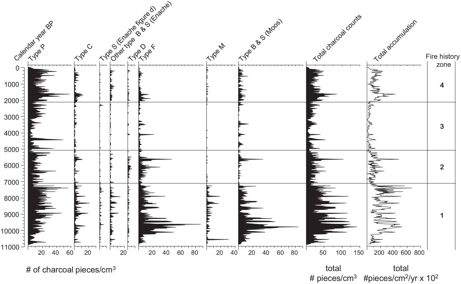
Paquette Lake Holocene fire history: Counts of morphotypes of macrocharcoal particles (>125 µm), total charcoal concentration (#pieces/cm3) and total charcoal accumulation (#pieces/cm2/yr). Zones are based on stratigraphically constrained cluster analysis and square-root transformation of morphotype counts. Calendar year BP is standardized to present (1950 common era (CE); Wolff, 2007).
Type P particles were the most common throughout the Paquette Lake record, with concentrations and accumulations being highest in the earliest (Zone 1) and most recent (Zone 4) zones (Figure 2). The shape of P particles is consistent with the shape of charcoal produced from the burning of leaves (Umbanhowar and Mcgrath, 1988). Other very common charcoal morphotypes included types F and B & S (Moos), which were at their highest abundance in the earliest period (~11,700–7100 cal yr BP, Zone 1). Type F particles are elongated and often fragile, and their frequent co-occurrence with type B & S in the Paquette Lake record suggest that S particles transported from the watershed into the lake (secondary transport) are a common source material for morphotype F (Enache and Cumming, 2006). As the Paquette Lake watershed is quite small, any secondary transport would be within ~5 km (Figure 1). Morphotype C was most common in Zone 1 and has been attributed to wood and tree bark and may reflect fires that occur close to the lake shore (Enache and Cumming, 2006). A high abundance of morphotype M from ~11,700 to 7100 cal yr BP (Zone 1) and the resurgence of type M in the most recent period ~2100–present (Zone 4) is of particular interest for identifying large, local fires (Enache and Cumming, 2006). Morphotype M has been associated with primary deposition into the lake and is indicative of larger local fires as the fragile and porous nature of morphotype M suggests that these particles form at high temperatures, a characteristic of high intensity or crown fires (Enache and Cumming, 2006; Moos and Cumming, 2012). Identification of large, local fires (close to the lake) is additionally supported by higher numbers of large charcoal pieces (>300 and 600 µm) present in zones 1 & 4 (Figure 3; Grochocki et al., 2019).
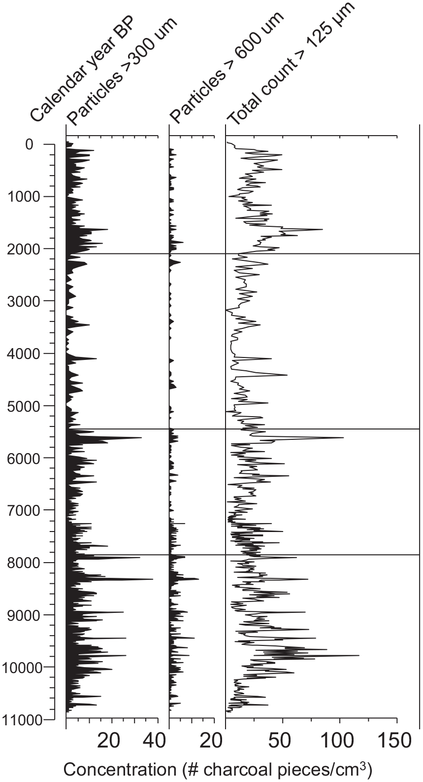
Paquette Lake Holocene fire history: Macrocharcoal size distribution counts of particles (>300 and >600 µm) and total concentration of particles (#pieces/cm3). Zones are based on stratigraphically constrained cluster analysis and square-root transformation of size category counts. Calendar year BP is standardized to present (1950 common era (CE); Wolff, 2007).
The mean fire-return interval (mFRI) based on the total macrocharcoal (>125 µm) varied within each zone from 122 to 241 years (Supplemental Material Figure S5), with the lowest return intervals (highest fire frequency) in the earliest period (11,700–7100 cal yr BP, Zone 1) and the most recent period (post ca. 2100 cal yr BP, Zone 4). These two periods also have the highest total charcoal accumulation, particularly in the earliest period with accumulations ~ twice that of the most recent period. The period with the highest mFRI (lowest fire frequency) was between 5100 and 2100 cal yr BP (Zone 2), which also had the lowest total charcoal accumulation. The counts of total macrocharcoal (>125 µm) and of large charcoal pieces (>300 µm) were highly correlated (r = 0.76, p < 0.0001; Supplemental Material Figure S5), indicating that the majority of the identified fire peaks throughout the Holocene are of local origin and/or represent high-intensity fires.
Peak identification and signal-to-noise ratios provide an index of confidence in the estimates of mFRI and fire frequency. Signal-to-noise index (SNI) > 3 typically separates charcoal peaks (signal) from noise (Kelly et al., 2011). The SNI was typically above 3 throughout the Paquette Lake charcoal record, with lower values more common in zones 3 and 4 (Supplemental Material Figure S6).
Paquette Lake vegetation history
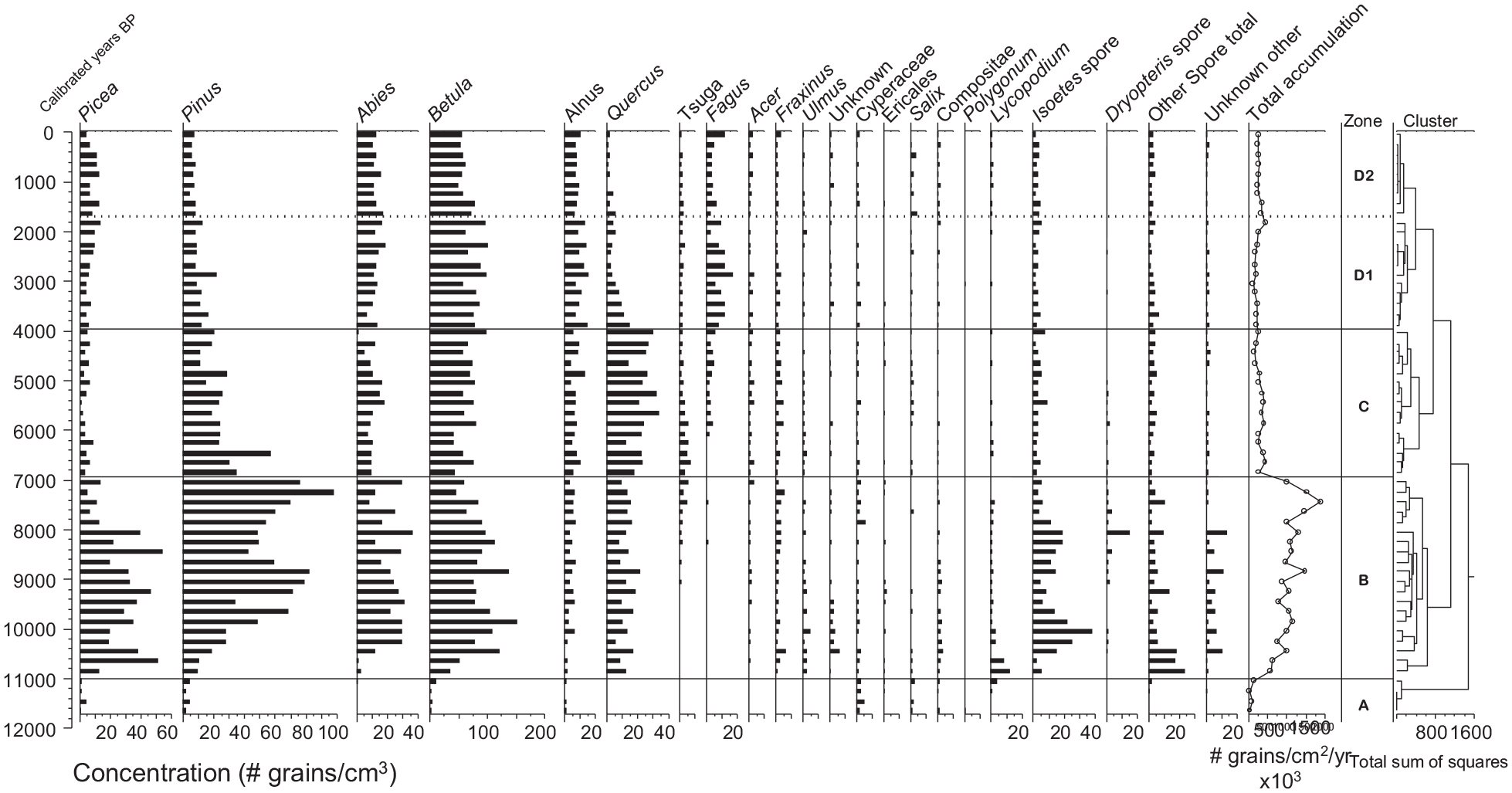
The pollen assemblages from Paquette Lake indicate a mixed forest of varying composition of coniferous and deciduous trees throughout the Holocene record (Figure 4). Pollen from the coniferous trees of Pinus (pine), Picea (spruce), and Abies (fir) were present throughout the record but changed in percentages (Figure 4) and concentrations (Figure 5). Pollen from deciduous Betula was the most common component of the pollen assemblage in both percent abundance and concentration. The dominance of Betula, and the difficulty of species differentiation that have large variation to optimal temperature and precipitation, hinders being able to reconstruct temperature and precipitation from our record (Chevalier et al., 2020). Other common deciduous components of the pollen assemblage included Alnus (alder), Fagus (beech), and Quercus (oak). Various spores (Lycopodium, clubmoss; Isoetes, aquatic to semi-aquatic; Dryopteris, wood ferns, and other rare spores) were present throughout the record.

Paquette Lake Holocene vegetation history: percent abundance of pollen types over the past ~11,700 cal yr BP at ~200-year resolution. Total concentration (# grains/cm3) on right. Zones based on stratigraphically constrained cluster analysis and square-root transformation of relative abundance data. Calendar year BP is standardized to present (1950 common era (CE); Wolff, 2007).
Paquette Lake Holocene vegetation history: concentration (#pollen grains/cm3) of pollen types over the past ~11,700 cal yr BP at ~200-year resolution. Total accumulation (# grains/cm2/yr) on right. Zones based on stratigraphically constrained cluster analysis and square-root transformation of concentration data. Calendar year BP is standardized to present (1950 common era (CE); Wolff, 2007).
Four distinct pollen zones were defined through cluster analysis (Figures 4 and 5). Pollen Zone A (~11,700–11,000 cal yr BP) is characterized by a very low concentration of pollen and higher percent abundance of Cyperaceae (sedges), Salix (willow), and Ericales (heaths) than in the other zones (Figure 4). A large increase in total concentration and accumulation occurred in the early Holocene (Zone B, ~11,000–7000 cal yr BP) and represents a period of very high pollen production (Figure 5). The concentrations of Pinus, Picea and Abies all reach their highest values in Zone B, with initial large increases occurring at ca. 11,000 cal yr BP for Pinus and Picea, and at ca.10, 400 for Abies cal yr BP. A high concentration of spores (Isoetes, Dryopteris, Lycopodium – clubmoss) also characterizes the early Holocene (Zone B). The mid-Holocene pollen Zone C (~7000–4000 cal yr BP) is characterized by an increased percent abundance and concentration of Quercus and the first appearances of Tsuga (hemlock) just prior to ca. 7000 cal yr BP. Both taxa declined in the late Holocene (Zone D, post ca. ~4000 cal yr BP), while Fagus increased from its first appearances in Zone C. Concentrations of Picea increased post ca. 2000 cal yr BP (Zone D2) from their lowest concentrations in the mid-Holocene, alongside small increases in Compositae (daisy family), Salix and Lycopodium (Figure 5). Ericales (heaths), a dominant feature of present-day barren vegetation near Paquette Lake, are present at only low concentrations through much of the record (Figure 5).
Estimates of the composition of pinus subgenera
Both Pinus subgenera (Strobus - haploxylon and Pinus - diploxylon) have been present since the start of the record (~11,700 cal yr BP) in Paquette Lake, with Pinus strobus more prevalent throughout much of the record (Supplemental Material Figure S7). The highest concentrations of Pinus subg. Pinus (in our region includes P. banksiana, P. resinosa) occurred between ~10,000 and 6000 cal yr BP. Around ~1000 cal yr BP, the percent abundance and concentration of Pinus subg. Pinus became slightly higher than or approximately equal to that of Pinus subg. Strobus.
Warren Lake vegetation history
The vegetation history of the dominant trees in the Warren Lake sedimentary record follows a similar trajectory to that of Paquette Lake, but with local differences in the percent composition over the past ~8,200 years (Figure 6, Supplemental Material Figure S8). Similar trends occur based on the concentration of pollen in the two lakes (Supplemental Material Figure S9). Pines (mostly white pine, Pinus strobus) were most common from ~8000 to 3000 cal yr BP and beech (Fagus) was most common in the last ~4,000 years. Highest abundances (albeit low) of the Pinus subg. Pinus (jack pine and red pine) in the Warren Lake record occurred between ~8000 and 6000 years (Supplemental Material Figure S7). The rise in hemlock (Tsuga) ca.7000 cal yr BP and sharp decline post ca. 5500 cal yr BP is more prominent in Warren Lake compared to Paquette Lake (Figure 6).
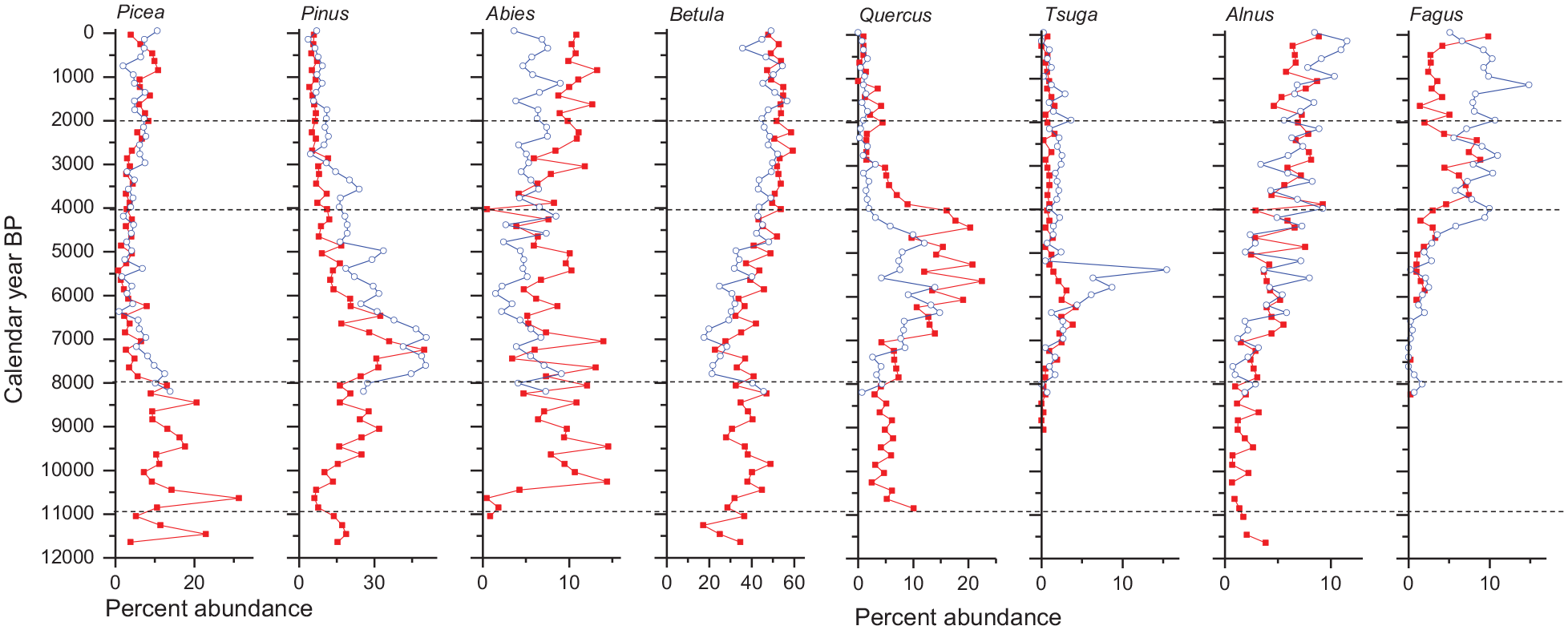
Common tree pollen grains based on percent abundance in Paquette Lake (solid red squares) and Warren Lake (open blue circles). Calendar year BP is standardized to present (1950 common era (CE); Wolff, 2007).
In Warren Lake, five pollen zones were differentiated based on cluster analysis of percent abundance (Supplemental Material Figure S8) and concentration (Supplemental Material Figure S10), indicating similar zonation. The earliest pollen zone (8200–6500 cal yr BP) was characterized by higher concentrations of Picea, Pinus and Abies, similar to the end of the early Holocene period in the Paquette Lake record, but with higher concentrations of Pinus strobus in Warren Lake (Supplemental Material Figure S9). The zone from 6500 to 4300 cal yr BP is characterized by the highest abundances (percent and concentration) of Quercus and Tsuga (Figure 6, Supplemental Material Figures S8–S10). An increase in Fagus characterizes the period post ca. 4300 cal yr BP. In addition to the increase in Fagus, the period 4300–2900 cal yr BP is characterized by a decline in Pinus. The pollen zone from ~2900 to 1500 cal yr BP is characterized by a further decline in Pinus and a small increase in Picea. The most recent pollen assemblage (~1500 cal yr BP–present) is characterized by further small declines in Pinus, Betula, and Tsuga. Although barrens are within the watershed of Warren Lake (Figure 1), they are distant from the lake and thus likely why Ericales were absent from the Warren Lake vegetation record.
Discussion
The distinct phases of the Paquette Lake fire and vegetation history can generally be divided into three periods often defined for the Holocene epoch, early, mid-, and late- (Walker et al., 2018). These millennial-scale changes in vegetation have been linked to changes in climate, glacial dynamics and solar insolation in North America (Marcott et al., 2013; Moy et al., 2002; Shuman and Marsicek, 2016). In this study, we use the sedimentary analysis of large charcoal particles (>125 µm) to provide a record of local watershed fire history (Hennebelle et al., 2020; Lynch et al., 2004a; Tinner et al., 2006), and the analysis of sedimentary pollen assemblages in the lakes to provide a broad perspective of Holocene vegetation and climate changes (Chevalier et al., 2020). The combination of high-resolution charcoal analysis of total counts and morphotypes with centennial-scale pollen analysis provides a unique record of fire and vegetation dynamics in this region.
Regional forcing on fire and vegetation in the early Holocene period
The early Holocene was a period of rapid change in vegetation influenced by the retreat of the Laurentide Ice Sheet in North America and increased warming due to higher solar radiation (Kutzbach and Webb, 1993; Webb et al., 1993). Deglaciation of the Maritimes region of eastern Canada generally occurred between ca. 14,000 and 13,000 cal yr BP and 12,000 cal yr BP (Hughes, 1987; Teller, 1987). However, sedimentological evidence and basal dates of lake sediments suggests that the Cape Breton Highlands area remained glaciated between ca. 14,700 and 12,900 cal yr BP, with the formation of lakes occurring as the Younger Dryas was ending (ca. 11,400 cal yr BP; Stea and Mott, 1998, 2005).
The deposition of glacial clays during the retreat of ice coincident with the ending of the Younger Dryas and the early formation of Paquette Lake is expressed by the very low organic matter (<10%) and low carbonates (<2%) from ~11,660 to 10,930 cal yr BP (Figure 7, Supplemental Material Figure S3). Pollen concentration and accumulation was very low, with a tundra habitat suggested by the early presence of sedges (Cyperaceae), willow shrub (Salix) and flowering plants (Ericales, Compositae, Polygonum; Figures 4 and 5). Other pollen studies in Nova Scotia (Supplemental Material Figure S11) also indicate very low concentration of pollen during this time (Green, 1987; Livingstone, 1968; Livingstone and Estes, 1967; Mott et al., 2009), with tundra inferred prior to ~10,300 cal yr BP at Wreck Cove on the Cape Breton plateau (Livingstone and Estes, 1967). In undated sediments, similar pollen assemblages were found at Upper Gillies and McDougal lakes in Cape Breton (Livingstone, 1968). Very cold and low-moisture conditions documented in eastern U.S. sites correspond to this tundra period (Davis et al., 2021; Shuman et al., 2019; Shuman and Marsicek, 2016).
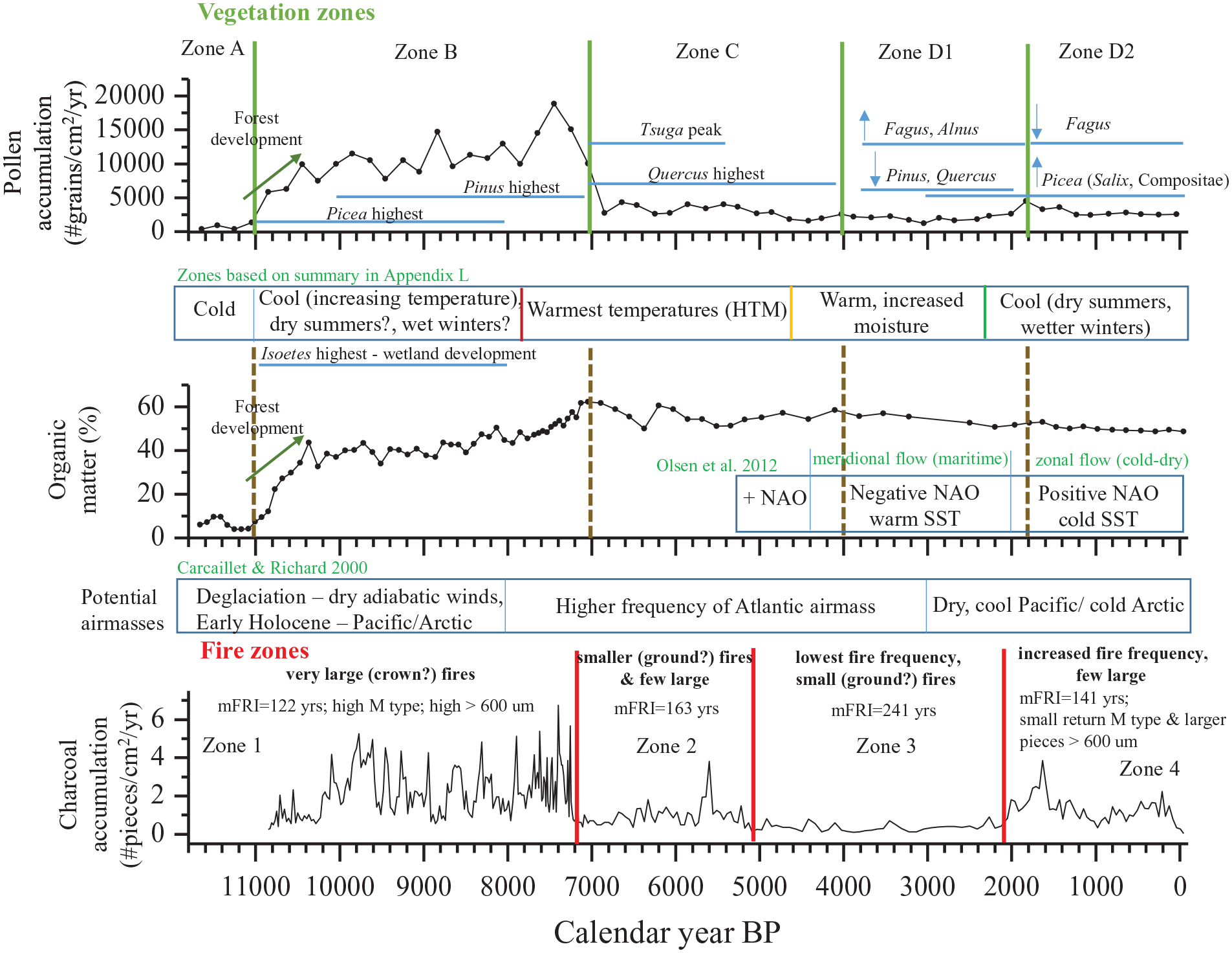
Summary of major vegetation and fire history zonation in the Paquette Lake sediment record, with associated synopsis of dominant changes in pollen, fire regimes, general atmospheric and climate conditions.
Development of forest is evident from the increasing accumulation of pollen and organic matter in the Paquette Lake sediments post ca. 11,000 cal yr BP (Figure 7), consistent with other Nova Scotia sites (Green, 1987; Lennox et al., 2010; Mott et al., 2009; Supplemental Material Figure S11). Initial sediment deposition following deglaciation would be dominated by inorganic input from the glacial clays. As the forest developed and the landscape stabilized, the percentage of organic carbon content in the lake sediments increased (Engstrom and Fritz, 2006). Many species of trees were found to rapidly expand into the deglaciated regions (Dyke et al., 2004). Increased concentrations of coniferous (Picea and Pinus) and deciduous trees (Betula and Quercus) indicate establishment by ca. 10,800 cal yr BP, followed by Abies ca. 10,400 cal yr BP, all of which are consistent with isopoll maps of the migration of tree species as the Laurentide Ice Sheet retreated (Jackson et al., 1997; Webb et al., 1993). The high abundance of aquatic spores (i.e. Isoetes), and other spores (Lycopodium and Dryopteris) suggests that a large wetland area and cool, moist forest immediately surrounded Paquette Lake. As warming occurred with increased solar insolation and the further retreat of Laurentide Ice Sheet generally northward of the St. Lawrence region (Dyke et al., 2004) Pinus pollen increased in percentage and concentration ca. 10,000–9500 cal yr BP.
The high frequency of large and local fires in the early Holocene indicated by the highest charcoal accumulation (Higuera et al., 2007), highest proportion of particles >300 µm (Grochocki et al., 2019; Oris et al., 2014) and highest proportion of morphotype M (Enache and Cumming, 2006) is likely related to a higher abundance of fuel (Lynch et al., 2004b; Prince et al., 2018), associated with the highest percentage and concentration of coniferous trees in the record (Supplemental Material Figure S12). Comparative studies of fire history in eastern Canada between dense needleleaf forest and mixed boreal forest over the past ~6000 years indicates higher production of charcoal and higher frequency of fires in forests with a higher proportion of conifers (Blarquez et al., 2015; Girardin et al., 2013). The high fire frequency (low mFRI) in Paquette Lake (ca. 11,000–7100 cal yr BP) is consistent with the reconstructed fire history in southern Quebec in which the highest fire activity occurred between ca. 10,000 and 7500 cal yr BP (Carcaillet and Richard, 2000). Carcaillet and Richard (2000) hypothesize that the early Holocene was characterized by dry summers due to the increased solar radiation and strong, dry adiabatic winds from the retreating ice sheet. Remnant glacier ice is inferred to have remained between ca. 13,200 and 11,400 cal yr BP north and northwest of Cape Breton (Stea and Mott, 1998), which depending on ice thickness may have increased the strength of winds at the end of the Younger Dryas.
Mid-holocene period of warmest temperatures (Holocene Thermal Maximum)
Many paleoclimate records in the Northern Hemisphere have identified a period of high warmth during the mid-Holocene, often referred to as the Holocene Thermal Maximum (HTM), Holocene Climatic Optimum or the old term Hypsithermal (Deevey and Flint, 1957; Renssen et al., 2009; Shuman and Marsicek, 2016; Vinther et al., 2009). In Paquette Lake, the transition from the mixed forest in the early Holocene, with greater concentrations of Picea and Pinus, to the mixed forest with peaks in Quercus and Tsuga occurred ca. 7000–4000 cal yr BP (Figures 5 and 7). The equivalent Quercus and Tsuga vegetation zone in Warren Lake occurred from ca. 6500 to 4300 cal yr BP (Figure 6, Supplemental Material Figure S8). This mid-Holocene Quercus and Tsuga zone is consistent with findings from the northeastern U.S. (Deevey and Flint, 1957; Shuman et al., 2019). Similar high abundances of Quercus occurred in other Nova Scotian sites, although the timing of these peaks is uncertain due to limited chronological constraints in earlier studies (Green, 1987; Livingstone, 1968; Livingstone and Estes, 1967). In Paquette Lake, this period overlaps with Fire zone 2 (~7200–5100 cal yr BP) in which the magnitude, frequency and intensity of large, local fires decreased from the highs seen in the early Holocene (Figure 7).
The peak in Tsuga overlaps with the highest abundances of Quercus in Paquette and Warren lakes but is most prominent in Warren Lake (Figure 6). The distribution of Tsuga today in the Warren Lake watershed is restricted to moist habitats of sheltered valleys and canyons, which may also account for the greater abundance in the Mid-Holocene period (ca. 6500–5000 cal yr BP). The occurrence of Tsuga in the Mid-Holocene is also recorded in several other Nova Scotia sites (Green, 1987; Livingstone, 1968; Livingstone and Estes, 1967; Mott et al., 2009; Neil et al., 2014), although lack of carbon dates or limited chronological constraints in the earlier records limits the ability to compare across all sites (Supplemental Material Figure S11). The rise and decline of Tsuga in Warren Lake from ca. 8000 to 5200 cal yr BP are similar to the pattern observed across many sites in eastern North America, although the driving forces, such as droughts and/or a pathogen or pest, behind the sharp and coeval decline are still debated (Bennett and Fuller, 2002; Booth et al., 2012; Shuman et al., 2019).
The estimated higher mFRIs (lower fire frequency) at Paquette Lake in comparison to the early Holocene from ca. 7100 to 2100 cal yr BP (Fire Zones 2 & 3, Figure 7) is consistent with fire history data from Quebec, with lower fire frequency between ca. 7000 and 3000 cal yr BP (Carcaillet et al., 2001; Carcaillet and Richard, 2000). The concentration and accumulation of pollen declined during this period likely as the result of the lower presence of the high pollen producers Picea and Pinus. The fundamental change in forest composition (declining conifers) ca. 7000 cal yr BP (Figure 5, Supplemental Material Figure S12) would greatly influence the fire regime (Blarquez et al., 2015; Girardin et al., 2013). Carcaillet and Richard (2000) hypothesize that in Quebec, the lower fire frequency of the Mid-Holocene was related to a higher dominance of the Atlantic air mass, resulting in wet summers.
Late-Holocene climate, vegetation, and fire
The late Holocene cooling ca. 6000–5000 years BP is thought to be the result of declining solar energy (Milankovitch cycle) that led to a southward shift in the position of the Intertropical Convergence Zone (ITCZ) and changes to the amplitude of the El Niño-Southern Oscillation (ENSOs; Hertig et al., 2015; Wanner et al., 2008), with further intensification of ENSOs post ca. 2000 cal yr BP (Moy et al., 2002). In the North Atlantic region ca. 4000–5000 years BP, sea temperatures decline (Bradley and Bakke, 2019), glaciers advance (Geirsdóttir et al., 2019) and shifts to wetter conditions occur (Finkenbinder et al., 2016; Orme et al., 2021). Concurrent changes in vegetation in Paquette Lake occur ca. 4000 cal yr BP, characterized by decreases in Quercus and Tsuga (with an earlier decline in Pinus ca. 5000 cal yr BP) and increases in Fagus, Betula, and Alnus (Figure 4). The late-succession and shade-tolerant Fagus was one of the last major tree taxa to establish in Nova Scotia (Bennett, 1985; Green, 1987), potentially related to its fire susceptibility and initial competition with established species (Fuller, 1997). Huntley et al. (1989) argue that the main determinant of migration and establishment of Fagus is climate, particularly warmer winter temperatures and lower summer temperatures which are characteristic of the late Holocene.
Further late-Holocene changes in vegetation occur coincident with a shift to cooler sea surface temperatures (SSTs) and an increase in sea ice ca. 2000 cal yr BP, associated with the positive mode of the North Atlantic Oscillation (NAO) with cold, dry zonal flow across the region (Olsen et al., 2012; Orme et al., 2021). Pollen records from Nova Scotia indicate recent cooling with increases in Picea and other taxa, and declines in Pinus ca. 3000–2000 cal yr BP (Green, 1987; Lennox et al., 2010; Mott et al., 2009; Neil et al., 2014; Supplemental Material Figure S11). In Paquette Lake, small increases in Picea and a few other rarer taxa (Compositae, Salix, Lycopodium) occur ca. 2400–2000 cal yr BP (Figures 4 and 5), with similar changes in the Warren Lake pollen record (Supplemental Material Figure S10). Paleorecords in eastern and central U.S. also infer cooling temperatures ca. 2000 cal yr BP (Shuman et al., 2019; Shuman and Marsicek, 2016; Supplemental Material Figure S11). Concurrent with these vegetation changes, an increase in fire frequency is inferred in eastern Canada (Carcaillet and Richard, 2000) and Paquette Lake. Increased charcoal accumulation (higher fire frequency), increases in the larger pieces of macrocharcoal (>600 µm), and increased abundance of morphotype M indicate more local fires surrounding Paquette Lake ca. 2100 cal yr BP (Figures 2, 3, and 7). Increase in Picea along with higher fire frequency, may be associated with a higher influence of dry Cool Pacific or Cold Arctic air masses post ca. 2500 cal yr BP over eastern Canada (Carcaillet and Richard, 2000), and cold, dry zonal flow of a +NAO (Olsen et al., 2012). In turn, the higher abundance of Picea, a more flammable species (Blarquez et al., 2015; Girardin et al., 2013), could result in a higher fire frequency. The frequency and intensity of fire post ca. 2000 cal yr BP did not return to the levels observed in the early Holocene, potentially related to the lower Picea abundance in the late Holocene (Figures 5 and 7).
Summary of the holocene vegetation and fire history
The sedimentary record from Paquette Lake extends from the development of the lake following glacial retreat, tracks the initial establishment of tundra vegetation and the progressive development of early-Holocene forests and wetlands, and continues to the mixed forests of the early 20th century. The Paquette Lake charcoal record indicates that the early Holocene fire regime (ca. 11,000–7200 cal yr BP) was characterized by the largest and most frequent fires over the Holocene. Pollen analysis indicates the early Holocene was characterized by a mixed forest, with high abundances of Picea, Pinus, Abies, and Betula. High fuel availability, along with warmer and potentially drier conditions and dry winds, resulted in frequent (mFRI = 122 years) large and local to regional fires. As forests developed and changed on a millennial scale, the fire regime changed as well. The mid-Holocene fire regime (ca. 7200–5000 cal yr BP) is characterized by smaller, potentially ground fires, that were less frequent (mFRI = 163 years), in comparison to the early Holocene. Pollen analyses indicate decreases in the coniferous component with declines in Picea and Pinus, and maximum abundances of Quercus and Tsuga from ca. 7000 to 5000 cal yr BP. The sedimentary record from ca. 5000 to 2000 years BP indicates distinct changes in both the vegetation and fire regime. Fire frequency and size was at its lowest during this time (mFRI = 241 years). Quercus became a smaller component of the forest while Fagus increased, and Pinus declined from its high abundance in the early- to Mid-Holocene. Total concentration and accumulation of pollen was at its lowest of the entire Holocene. Based on the pollen and charcoal preserved in the Paquette Lake sediments, the early 20th century composition of the forest and fire regime were established at ca. ~2000 years ago. The transition into this period is characterized by an increase in Picea (although much smaller than the early Holocene increase), and an increase in fire frequency (mFRI = 141 years) and larger local fires, though not to the scale that occurred during the early Holocene. The estimated mFRIs from the Paquette Lake record are similar to those across Quebec ranging from ~150 to 300 years (Frégeau et al., 2015; Payette and Frégeau, 2019; Remy et al., 2017). The large topographical variation (variable soil moisture, drainage, and vegetation), and presence of numerous fire breaks such as lakes and other water bodies in northern Cape Breton also tend to decrease fire frequency and size in the region (Grimm, 1984; Larsen, 1997; Nielsen et al., 2016).
The history of the dominant trees in the Warren Lake sedimentary record proceeds along a similar trajectory to the record from Paquette Lake but with some local differences in the composition of the forest over the past ~8,200 years (Figure 6). Abies is more common in Paquette Lake throughout the Holocene, while Pinus strobus is more common in the valleys of Warren Lake. During the mid-Holocene warm period, Quercus reaches its highest abundances on the plateau region surrounding Paquette Lake, where it sparsely occurs today, while Tsuga is highest in the valleys surrounding Warren Lake. In the late Holocene, ca. 4000 cal yr BP, Fagus increases in both watersheds, but with higher abundances in the valleys surrounding Warren Lake. Post ca. 2000 cal yr BP, Alnus increases in the valleys of Warren Lake while Picea becomes more common on the plateau around Paquette Lake post ca. 1000 cal yr BP.
Conclusions: Climate-vegetation-fire interactions and future projections
Changes in the proportion of needleleaf and broadleaf trees in the Holocene record from Paquette Lake generally follow the inferred fire regime zones. As in other studies (Jensen et al., 2007; Mustaphi and Pisaric, 2014), changes in the macrocharcoal morphotypes were coeval with changes in fire regime based on total macrocharcoal accumulation. The highest proportion of conifers occurs in the early Holocene (~11,000–7000 cal yr BP) and is associated with the shortest estimated mFRI (122 years) and the greatest number of large, local fires (high abundance morphotype M and particles > 600 µm; Figures 2, 3, and 7). Higher biomass burning (higher charcoal accumulation) is often associated with a high proportion of conifers (Bernier et al., 2016; Blarquez et al., 2015; Girardin et al., 2013; Hély et al., 2020). Consistent with this relationship, longer mFRI (163 years) and smaller fires from ca. 7000 to 5000 cal yr BP occur as the proportion of conifers decline. The lowest percentage of total conifers occurs ca. 5000–3000 cal yr BP and is associated with the period of longest mFRI (241 years) of the Holocene record. Post ca. 3000 cal yr BP the percentage of conifers increases slightly with the increase in Picea and a corresponding decrease in estimated mFRI (141 years) with some larger fires based on charcoal morphotype and size of particles (Figures 2 and 3).
Several studies have related ocean and atmospheric dynamics to fire regimes, including NAO and ENSO (Boulanger et al., 2013). The mode of the NAO highly influences temperature and precipitation patterns and SSTs across the North Atlantic region (Olsen et al., 2012; Orme et al., 2021). The NAO has been in a more positive state since 1970 (Visbeck et al., 2001), with cold SSTs and more sea ice, and generally cooler air temperatures from higher dominance of Pacific airmasses and zonal atmospheric flow. As climate impacts are projected to be regionally heterogeneous, changes to fire regimes will also be spatially variable and influenced by forest composition, age structure, and moisture regimes (Bergeron et al., 2010; Boulanger et al., 2013). Projections of increased droughts and warming in the boreal zone of western Quebec and eastern Ontario predict an increase in the burn rate, but these projections fell within the natural variability observed in the paleo-records, possibly indicating a resiliency within the boreal ecosystem (Bergeron et al., 2010). Other studies have also hypothesized a resilience of the boreal forest to changes in mean fire intervals, particularly if the burn rates are within the range of natural variability (Carcaillet et al., 2010; Portier et al., 2016). Climate projections for the near future (into 2050) and later (2051–2080) for northern Cape Breton indicate increased warming, particularly in the winter months with fewer days below freezing, and increased precipitation, particularly in the spring and winter (Environment and Climate Change Canada, 2018). While the interactions between atmospheric and oceanic changes, and landscape, fire and vegetation dynamics are complex and difficult to predict with any accuracy, records of fire and vegetation, such as presented in this study, provide critical baselines for modeling future scenarios.
Supplemental Material
sj-pdf-1-hol-10.1177_09596836251327732 – Supplemental material for A 12,000-year perspective of fire and vegetation history in Northern Cape Breton, Nova Scotia, Canada
Supplemental material, sj-pdf-1-hol-10.1177_09596836251327732 for A 12,000-year perspective of fire and vegetation history in Northern Cape Breton, Nova Scotia, Canada by Kathleen R. Laird, Anne-Claude Pépin, Katherine E. Moir and Brian F. Cumming in The Holocene
Footnotes
Acknowledgements
We thank James Bridgland for the initiation of this project and his thoughtful guidance throughout. We thank graduate students: Graham Mushet and Cale Gushulak for field work assistance and undergraduate summer student, Angie Ng, for assistance with core sectioning and charcoal preparation.
Author contribution(s)
Funding
The author(s) disclosed receipt of the following financial support for the research, authorship, and/or publication of this article: Funding for this project was provided in part by Parks Canada Contribution Agreement GC-1168.
Supplemental material
Supplemental material for this article is available online.
References
Supplementary Material
Please find the following supplemental material available below.
For Open Access articles published under a Creative Commons License, all supplemental material carries the same license as the article it is associated with.
For non-Open Access articles published, all supplemental material carries a non-exclusive license, and permission requests for re-use of supplemental material or any part of supplemental material shall be sent directly to the copyright owner as specified in the copyright notice associated with the article.