
Abstract
South America’s Pacific margin is subject to recurring subduction-zone earthquakes that have generated devastating historical tsunamis, as well as earlier events impacting indigenous populations that have lived along the region’s rich upwelling coastlines throughout the Holocene. Despite recurring events, the geologic record of paleo-tsunamis is relatively sparse. Here we report evidence for two paleo-tsunamis striking the Chicama River coastline (8°S) around 2.8 and 2.0 ka. The two sedimentary deposits are amalgamated in many locations and can be difficult to distinguish, but floodplain or shoreface deposits separate the two units when traced landward and seaward, respectively. The magnitude of each event was sufficient to erode coarse cobbles (13–25 cm) from the shoreface and transport them ~100 m before being deposited as rapidly thinning and fining gravel units. Based on the distribution of mobilized cobbles, we consider plausible flow characteristics for the two tsunamis suggesting that each was on the order of at least a few meters in height with most of the cobble transport occurring only under critical to supercritical flow at the wave front. Previous archaeological reports from the area correctly recognized the older tsunami event but did not describe the younger, better-preserved second event. Further, we revisit the archaeological evidence for the tsunami and recast the older event as likely being more moderate than previously suggested. Broader archaeological evidence from this 30-km reach of the Chicama valley shoreline also suggests that the late Cupisnique to Salinar and Gallinazo cultures were not severely disrupted by the tsunamis, even with these events undoubtedly impacting nearshore inhabitants at the time.
Introduction
Tsunamis are long-period, surface-gravity waves capable of rapid, high-energy inundation of coastal systems, often hundreds of meters or more inland. Such inundation can modify coastal landforms, destroy infrastructure, and cause significant loss of life. Although tsunamis occur globally, they are most frequent along tectonically active margins where sea-floor disturbances are more regular (e.g., fault ruptures, marine slides). Particularly large, devastating tsunamis in 2004 (Indian Ocean) and 2011 (Tohoku, Japan) prompted many studies centered on the science of tsunami generation, wave hydrodynamics, coastal impacts, and historical and geological records. In South America, the tectonically active Andean margin is well known for large historical earthquakes and associated tsunamis (Dorbath et al., 1990; León et al., 2023; Pelayo and Wiens, 1990; Spiske et al., 2013a). Despite this recognition, there have proven to be relatively few good geological archives along the 7000-km coastline, and the generally poor recording of events coupled with sparse age data has proven widespread event correlation to be difficult (Goff et al., 2020, 2022; Spiske et al., 2020b). Here we report evidence for two paleo-tsunamis along the north Peruvian coast (8°S) that do not appear to correlate with other well-constrained reports and may thus reflect discrete events. Archaeological studies conducted in the area by Junius Bird from 1944 to 1946 do correctly identify the timing and occurrence of the older tsunami (Bird, 1948), and we present here detailed geological evidence for this event and another younger tsunami, as well as their impacts on local archaeological sites and cultures.
The study site is located ~35 km north of the modern city of Trujillo (pop. ~1 million) along a reach of shoreline fed by the Chicama River. Over the Holocene, water and sediment from the Chicama have constructed a broad gravel shoreface and an adjacent silty floodplain that have supported persistent human occupation since at least 14 ka (Dillehay, 2017; Dillehay et al., 2012; Goodbred et al., 2020). The productive marine zone and extensive coastal wetlands and lagoons contributed to the development of one of the largest, most complex Preceramic archaeological sites along the Andean margin, exemplified by Huaca Prieta (Bird, 1948; Bird et al., 1985; Dillehay, 2017). Huaca Prieta is an earth and cobble-structured mound covering 0.8 hectares; it lies adjacent to the shoreline atop a 6–7 m high Pleistocene terrace and extends another 23 m in height for a total elevation of 32 m above sea level (Figure 1). The 4000-year period of Preceramic mound construction at Huaca Prieta ends ~3.8 ka, shortly before the maximum shoreline transgression when waves eroded the seaward margin of the mound (Bird et al., 1985; Dillehay, 2017). Adjacent to Huaca Prieta, the early-ceramic Cupisnique culture constructed a much smaller adobe-brick mound that was active from ~3.4 to 3.1 ka (Dillehay, 2017). The 1-km2 Pleistocene terrace also hosts three much larger, Mochica adobe-brick pyramids, the huacas Paredones, Cortada, and Cao Viejo, which were built 1.8 to 1.4 ka, two of which are situated well back from the shoreline.
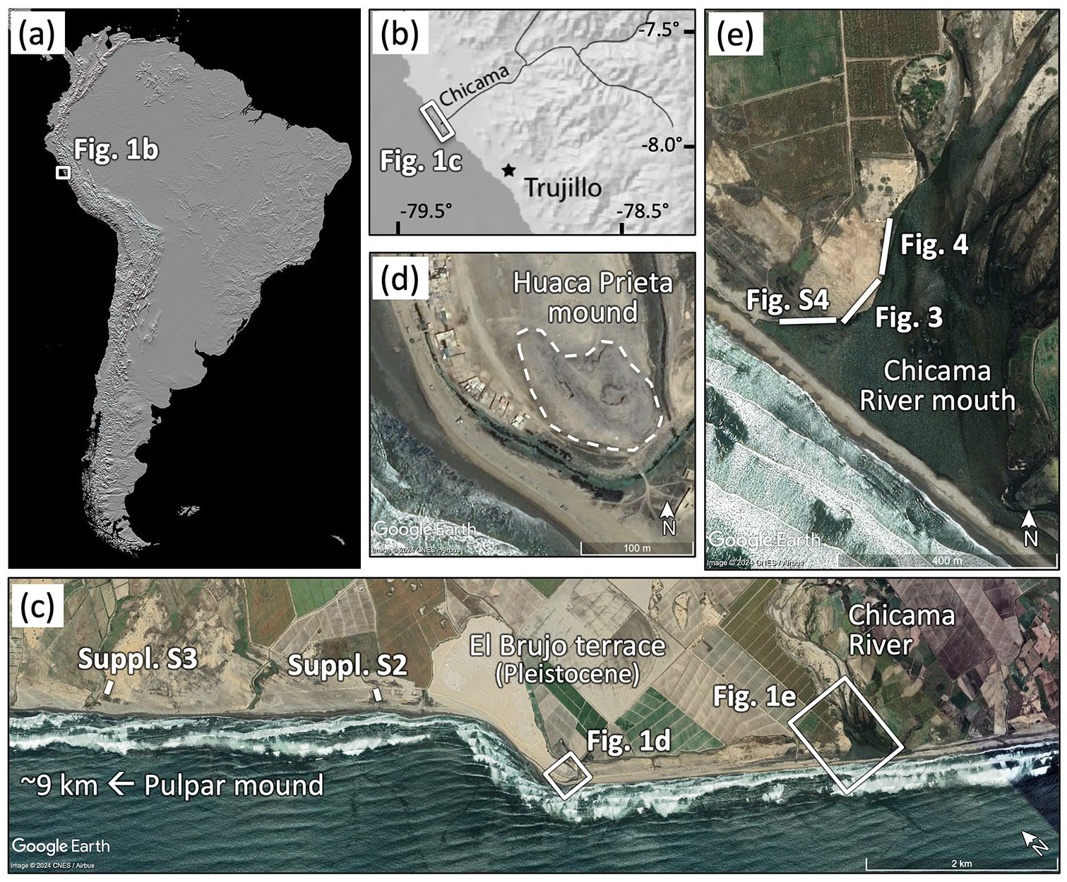
Study area, sampling sites, and figure locations. (a) Shaded-relief map of South America showing location of (b) study area along the Pacific Andean margin (source NASA). Satellite images labeled with major features and figure locations for (c) the Chicama River coastline and insets of (d) the Huaca Prieta Preceramic mound and (e) the river mouth (source Google Earth).
Methods
The lower Chicama Valley and adjacent areas support several distinct environmental settings: (1) coarse, arid alluvial fans, (2) the Chicama River channel-floodplain system, (3) ephemeral wetlands and lagoons, and (4) the coastal shoreface complex. The presence and distribution of these settings have changed considerably through the Holocene under the influence of climate, sea level, sediment supply, and anthropogenic impacts. Here we focus on the coastal system where shoreface dynamics have been controlled by sea-level change, the region’s high-energy wave climate, the ENSO-impacted delivery of Chicama River sediment, and two well-recorded high-energy events.
This research was conducted through sampling and descriptions of Holocene stratigraphy throughout the lower Chicama valley, coast, and alluvial systems. Sedimentary facies and stratigraphy were described from exposed sections along river cutbanks and within modern irrigation and boundary ditches. The best exposures and highest quality data were mapped along a 3–4 m high cutbank that extends from the Chicama River mouth to ~1.5 km upstream. Supporting data from generally lower-quality trench exposures were also mapped at sites located 3–8 km north of the rivermouth, demonstrating that the high-energy events were widely recorded, if not easily studied. The key evidence presented in this paper are drawn from the geometry of stratal truncation surfaces plus other taphonomic, weathering, and facies contexts.
The chronology of coastal events and depositional history is constrained by six radiocarbon ages measured on charcoal, organic sediment, and gastropod shells (Table 1; Figure 2). Care was taken to select high quality samples, either in-situ organic matter, charcoal, or shell that was well preserved. Whenever possible, organic carbon was analyzed to avoid carbonate reservoir corrections. All ages were calibrated using CALIB 8.2 and the SHCal20 calibration dataset for organic carbon (Hogg et al., 2020) and MARINE20 calibration dataset for marine shell material (Heaton et al., 2020). On the charcoal samples, inbuilt ages do not appear to affect our results, but the burning of old wood has been shown to yield up to a century or two offset in some systems (Gavin, 2001). For the one freshwater mollusk sample (HP-C5), the radiocarbon age was calibrated using the SHCal20 file and no reservoir correction was applied because the sample is presumed in equilibrium with atmospheric CO2, an assertion supported by its ∂13C value of −9.8‰ that largely precludes modern seawater or ancient carbonate influences. Table 1 displays mean radiocarbon ages in both calibrated years BP (cal yr BP, referenced to 1950) and Common Era (CE) notations and are presented with two-sigma uncertainty. Ages reported in the text are simplified to “ka” (kiloannum) based on their calibrated age.
Radiocarbon dates and calibrated ages.
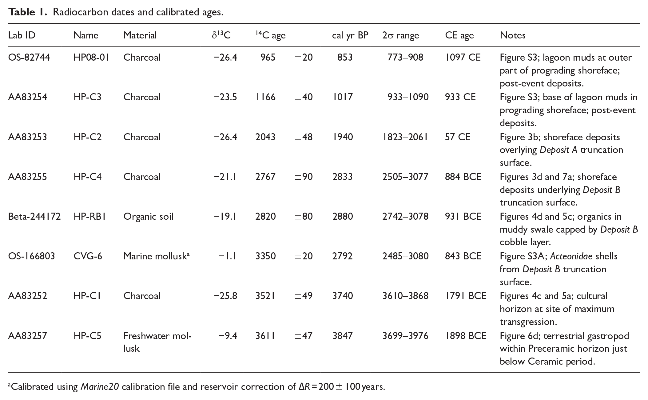
Calibrated using Marine20 calibration file and reservoir correction of ∆R = 200 ± 100 years.
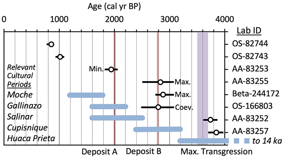
Distribution of mean calibrated radiocarbon ages and their 2σ range. Full radiocarbon results are given in Table 1. Ages are noted as placing minimum, maximum, or coeval constraints on the timing of Deposits A and B. Plot is labeled with the timing of relevant cultural periods, the occurrence of Deposits A and B, and approximate timing of maximum shoreline transgression.
Results
Holocene coastal sequence
A well-developed succession of Late-Holocene shoreface deposits extends several hundred meters across the modern coast and consists primarily of sands and pebble- to cobble-sized gravels. These coarse sediments are sourced primarily from the Chicama River, with secondary inputs from aeolian transport, local arroyo channels, and via transgressive ravinement of pre-Holocene alluvium (Goodbred et al., 2020). Although the Chicama River is the major sediment source for this coast, water discharge and sediment delivery is highly intermittent in this hyper-arid margin, largely tracking ENSO-modulated precipitation (e.g., Makou et al., 2010; Moy et al., 2002; Rein et al., 2005). As a result, the sequence of shoreline deposits formed along the Chicama valley coast reflects short intervals (100–101 years) of shoreface retreat and progradation related to decadal-scale climate variability. These are superimposed upon longer-period (102–103 years) transgressive and regressive trends controlled primarily by eustatic sea-level and sediment supply (Goodbred et al., 2017; Rogers et al., 2004; Wells, 1996). As for most of the world’s shorelines, transgression dominated through the Mid-Holocene, reaching maximum transgression ~3.5 ka. Afterwards, the shoreline tendency shifted into a largely regressive, progradational phase through the Late-Holocene, a period when most of the existing coastal sequence was deposited (Goodbred et al., 2017). This Late-Holocene succession of coarse-grained coastal sediments is ~3–4 m thick and unconformably overlies fine-grained backbarrier and floodplain soils that date to the early-Mid-Holocene. The most-inland of these shoreface deposits onlap with backdune sands and mark the position of the maximum Holocene transgression, which lies ~250 m landward of the modern shoreline. From that inland position, the shoreface subsequently prograded ~150–200 m with little apparent change in sea level, but a lower shoreface terrace that extends another 50–100 m to the modern shoreline indicates ~1-m drop in relative sea level in the latest Holocene (after ~1 ka).
Coastal sedimentary facies
The succession of coastal sediments along the Chicama coast comprises three main sedimentary facies that represent the following sub-environments: (1) the subtidal wave-swept terrace, (2) sand and gravel shoreface berms, and (3) aeolian back dunes and swales. We also describe a fourth non-coastal facies of thick mud units that anomalously overlie the coastal succession and are related to ENSO flooding events. Finally, in the section Event surfaces and deposits we describe three distinct sedimentary facies associated with high-energy events.
Wave-swept terrace
The base of the Chicama shoreface sequence is a 50–100 cm thick unit of well-stratified coarse sands and pebbles. These sands and gravels are organized into <2 cm thick, horizontal planar beds that contain abundant sand-sized shell hash. The deposit is formed in the surf zone just seaward of the shoreline. At low tide, this facies can be seen to intersect the base of the much steeper shoreface. Because the wave-terrace deposits interact with breaking waves and lie close to mean low water, they are a useful sea-level indicator (Bluck, 2011; Wells, 1996). In the Chicama coastal sequence, these wave-terrace deposits are easily tracked and found to occur at roughly the same elevation over the full width of the coastal sequence (Goodbred et al., 2017). This finding indicates that sea level was largely stable from the point of maximum transgression through most of the Late-Holocene coastal progradation.
Gravel and sand shoreface berms
Overlying the wave-swept terrace deposits are an alternating series of inclined gravel and sand beds that represent the active shoreface at the time of deposition. The gravel shoreface units comprise steeply dipping (15° ± 5°) beds of coarse pebbles and cobbles that are 50–100 cm thick and often normally graded (i.e., fining upward). These gravel units are interspersed with sandy shoreface deposits that may be up to 5–10 m wide and onlap against the gravel berms. The sands comprise low-angle swash beds (2° ± 1°) that indicate the active, high-tide shoreface.
At the rivermouth, these alternating sand and gravel shoreface units reflect episodic inputs of sediment from the gravel-braided Chicama River. The coarsest fraction of this fluvial-sediment supply deposits at the river mouth and is subsequently reworked onshore and alongshore by wave activity to form the shoreface berms (e.g., Engels and Roberts, 2005; Wells, 1996). The sand fraction is remobilized quickly (months to years) to form a sandy shoreface, whereas the larger gravel clasts take several years to rework into the well-developed gravel berms that are preserved in the succession. Longshore transport remobilizes the Chicama River gravels northward, with most being trapped at the El Brujo headland 3 km updrift of the rivermouth (Figure 1c). Beyond the headland terrace, the coastal deposits become more sand dominated, although they are locally augmented by gravels where mid-Holocene transgression had ravined into coarse alluvial deposits.
Aeolian and floodplain deposits
Associated with the shoreface units are local aeolian dunes that extend up to 100 m inland of the maximum shoreline transgression. These paleo-dunes form discrete lenses of sand (50–100 cm thick) that are generally small and localized. As preserved in the stratigraphy, the sands are typically iron stained and partially cemented by authigenic iron oxides. The oxide cements appear to be mediated by respiration in the root zone of the densely colonizing saltgrass, Distichlis spicata (L.) Greene (Poaceae). At the rivermouth, nearly the entire coastal sequence is capped by a 50–100 cm thick unit of fluvial muds that can locally reach 300 cm in thickness within inter-berm swales. These muds were deposited by El Niño floodwaters that overtopped the coastal units and represent multiple depositional events, each distinguished by a thin basal sand layer. All of these deposits post-date the high-energy events, so we do not discuss them in detail here, but they do reflect a well-preserved record of major river floods.
Event surfaces and deposits
Chicama rivermouth sites
Deposit A – Preserved within the prograding coastal sequence are several unique sedimentary structures that record two cross-shore erosion-deposition events. The most notable of these structures is a broad, curvilinear truncation (erosion) surface that cross-cuts the entire ~4 m-thick coastal sedimentary succession at a shallow angle of ~3°, an orientation that is distinct from the 15° slope of the gravel shoreface berms (Figure 3). At the base of the coastal succession, the truncation surface cross-cuts subtidal wave-terrace deposits and then rises vertically to cut across the overlying sand and gravel shoreface units. Along this path, the truncation surface has planated the tops of the gravel berms to form a ~15–30 cm thick gravel bed that consists of cobbles and pebbles reworked from the truncated shoreface deposits. Further landward, the surface becomes conformable and drapes onto adjacent backdune and floodplain deposits (Figure 4). The clasts comprising the gravel units have a-axis measurements ranging 5–25 cm (i.e., pebbles to cobbles), with the smaller clasts being mostly spheroidal and the largest clasts more discoidal in shape.
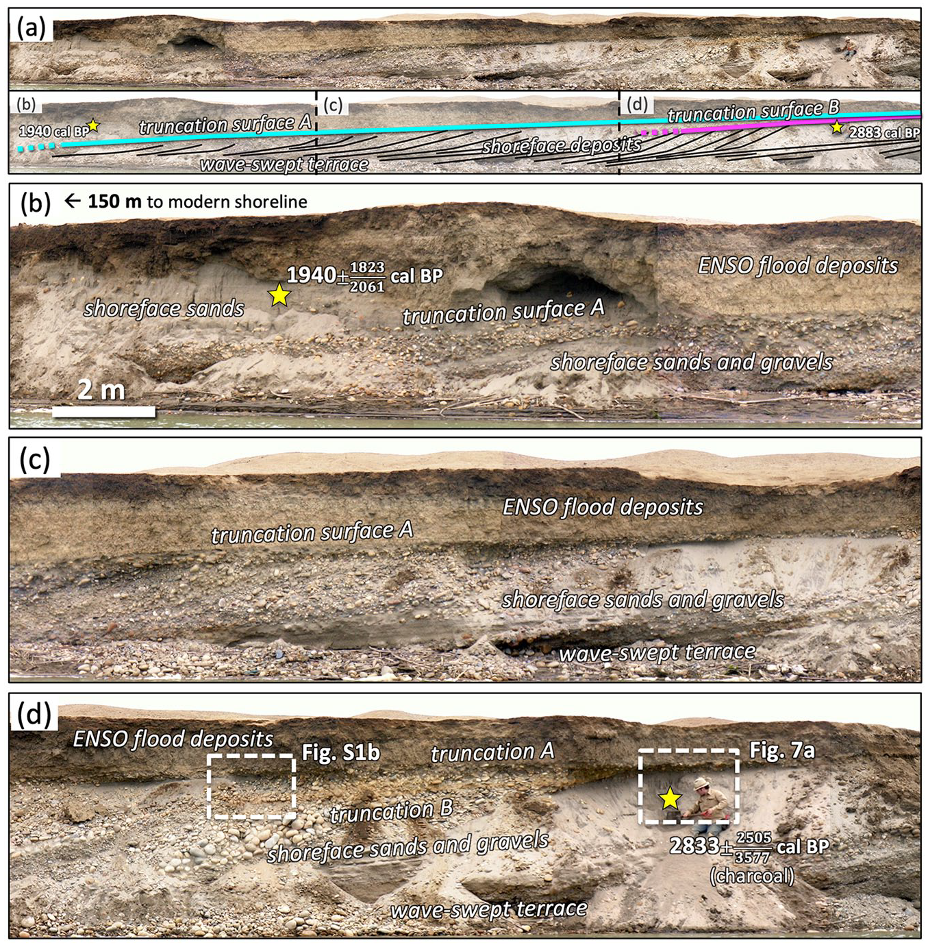
Paleo-coastal sediments exposed along cutbanks of the Chicama River mouth, with the location shown in Figure 1e. Images are annotated with major sedimentary and stratigraphic features and calibrated radiocarbon ages and 2σ ranges. Panel (a) shows original and interpreted images for a 60-m long section and its close-up panels (b–d). The images capture (b and c) the erosional reach of the Deposit A truncation surface, where coarse cobbles were scoured from the paleo-shoreface and transported landward. In panel (d) Deposit A intersects the weathered Deposit B truncation surface and becomes amalgamated along this section. Close-up images of the amalgamated section are shown in Figure 5 and Supplemental Material S1b. Note that the coastal sediments are capped by thick mud units deposited high-discharge river floods.
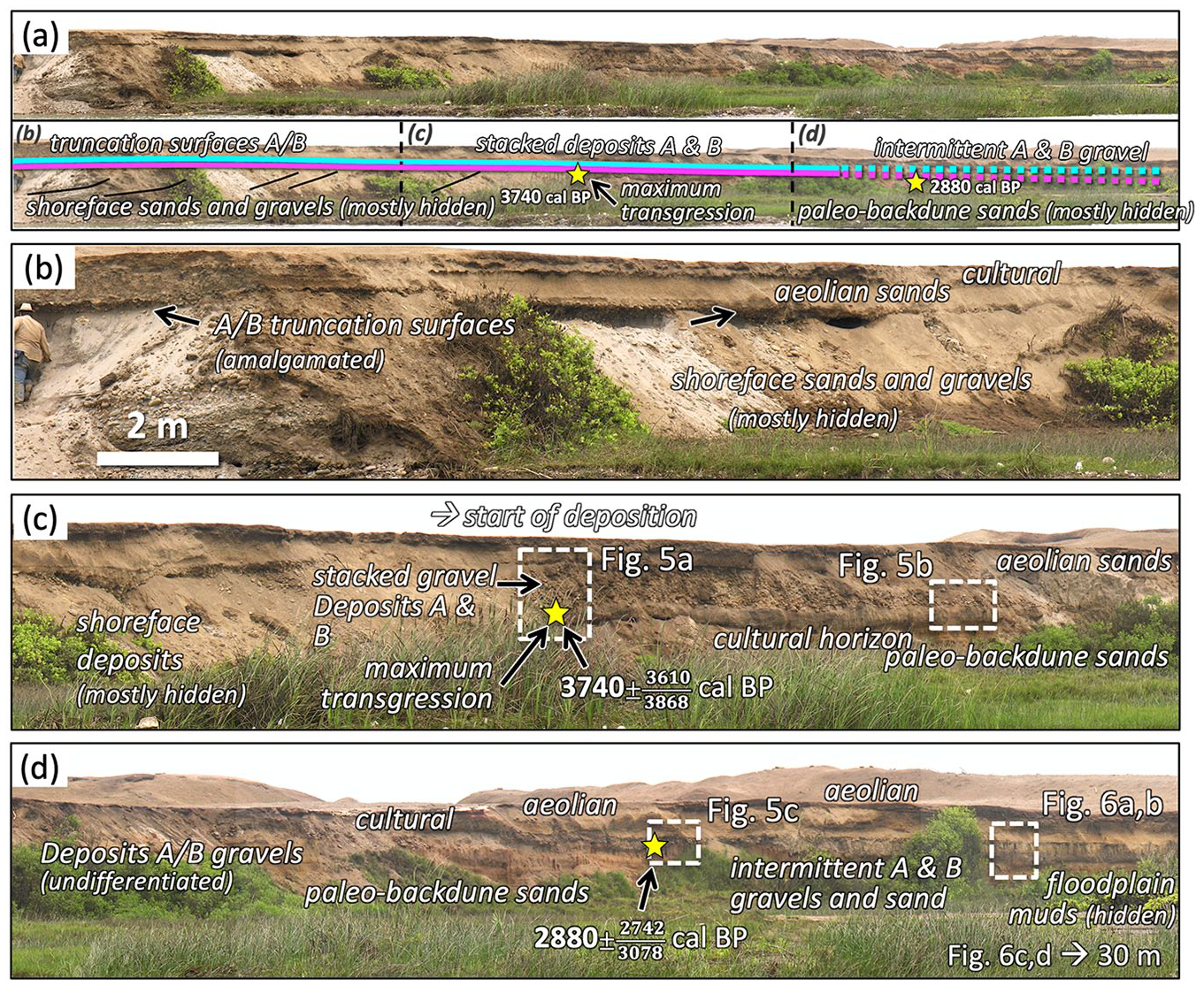
Paleo-coastal sediments exposed along the Chicama River cutbanks. The seaward (left) edge of this section is contiguous with Figure 3 and the location shown in Figure 1e. Sedimentary and stratigraphic features and calibrated radiocarbon ages and 2σ ranges are labeled. The images are slightly oblique and (a) cover ~90 m of coastal section that is inclusive of (b and c) the transport reaches and (c and d) depositional reaches for Deposits A and B. Deposition of the fine-to-coarse cobbles eroded from the paleo-shoreface (Figure 3) begins in panel (c) and continues through panel (d) where the Deposit A and B gravels become increasingly intermittent before transitioning into a very thin sand bed.
The most seaward point of the truncation surface is presumed to correspond with the paleoshoreline at the time of formation. From this position, the gravel deposit continues inland for another ~130 m before it transitions into a thin sand layer (Figures 4 and 5). Across most of this distance, cobble-sized clasts are readily available for transport from the underlying berms, but beyond the point of maximum transgression and into the backdune setting, the gravel unit thins and becomes more intermittent before disappearing after ~30 m (e.g., Nichol et al., 2003; Figures 4c and 5a and 5b). Beyond the limit of gravel deposition, a thin (1–5 cm) sand layer extends another ~100 m inland, draping onto the adjacent floodplain (Figure 5c and d). In total, the gravel and sand beds extend 200–250 m inland from the start of the truncation surface. Within the gravel unit, the clasts show neither significant sorting nor obvious imbrication, unlike the graded shoreface deposits beneath them. However, many of the cobble clasts at the top of the truncation bed are fractured from salt weathering (i.e., post-depositional), indicating that they were exposed at the ground surface for at least decades prior to burial beneath later muddy flood deposits.
Depositional zone for Deposits A and B. Locations shown in Figure 4. Panel (a) shows the point of maximum transgression where shoreface sands and cobbles onlap the burned sands of a backdune cultural deposit. Deposits A and B overlie the shoreface and cultural units, with each separated by an orange-colored paleosol (see Supplemental Material S1). Just 12 m landward (b) the amalgamated Deposits A and B have thinned considerably and by 30 m from panel (a) the gravel beds are becoming scattered and intermittent.
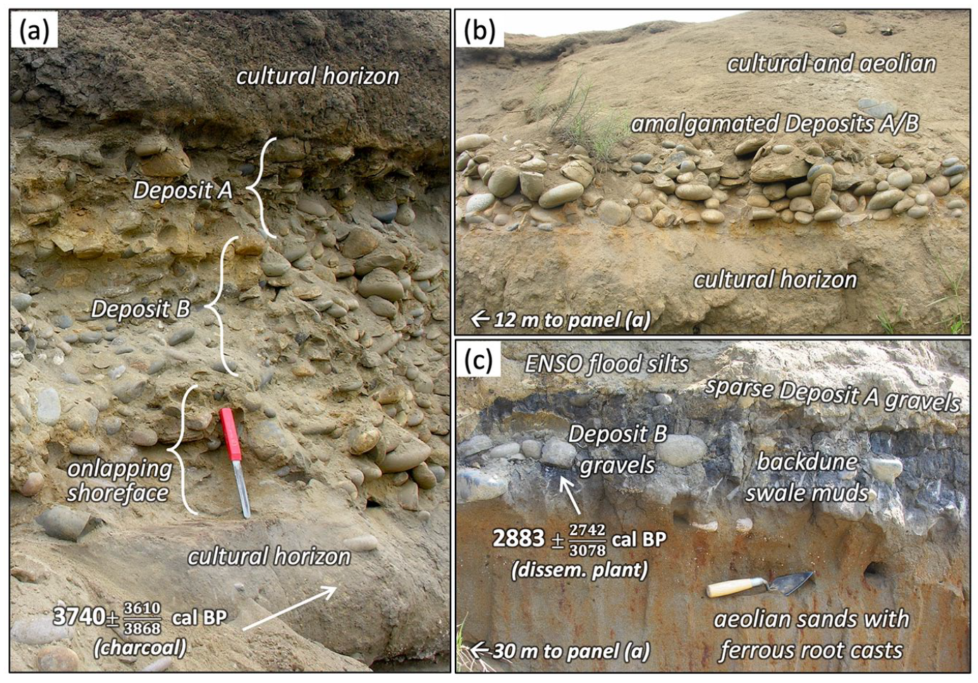
Deposit B – Below the Deposit A truncation surface and cobble unit lies a similar gravel bed and truncation surface (Deposit B). The contact between these two units is marked by a residuum of orange-colored, Fe-oxidized sand formed by salt-weathering of the sandstone and quartzite gravel clasts (Figure 5a; Supplemental Material S1 and S3). The formation of this weathering residuum indicates that the gravel units are unconformable and deposited at different times. This is further confirmed by tracing the contact laterally. In the seaward direction, the gravel beds diverge as the older truncation surface (Deposit B) dips downward and becomes separated from Deposit A by intervening shoreface sands (Figure 3d; Supplemental Material S1b). Unfortunately, most of the seaward-dipping portion of Deposit B was eroded after deposition, thus removing the distinctive curvilinear surface recognized in Deposit A. In the landward direction, the contact between the gravel beds separates again as the units become thinner and more discontinuous. The beds eventually fine to thin sand layers that are separated by ~60 cm of floodplain silts deposited by the Chicama River between the two events (Figures 5 and 6). In this section of the deposit, a human fibula (lower leg bone) was found buried within the sand and gravel deposit (Figure 6b). No other cultural or human remains or burial contexts were associated with the fibula, and we presume that it was eroded during the truncation of the gravel shoreface berm where shallow graves are frequently located.
Distal depositional zone for Deposits A and B. Locations shown in Figure 4 and are landward of maximum transgression, thus deposits are dominated by fluvial overbank sediments. At these distal sites, Deposits A and B are no longer amalgamated and once again form discrete strata. Panels (a and b) show the continuing thin, intermittent Deposit A and B gravel beds including a human fibula presumably exhumed from a grave eroded from the shoreface deposits. Tracing Deposits A and B nearly 100 m inland of the maximum-transgression site, panels (c and d) show the deposits to have been reduced to thin sand horizons within the floodplain succession.
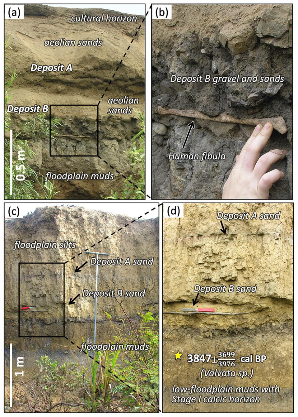
One distinction between the gravel units is that Deposit B hosts a matrix of coarse sands with abundant shell fragments (Figure 7a). These shelly sands are similar to those comprising the wave-swept terrace deposits, indicating that they were transported onshore from the adjacent surf zone and nearshore bed. Most interestingly, these matrix sands from Deposit B are found to infill underlying faunal burrows, where they have formed weakly indurated fossil casts. The burrows are ~30 cm deep, ~3 cm in diameter, and excavated from swash-bedded, fine-sand shoreface deposits. The size and depositional setting of these burrows suggest they are from the painted ghost crab (Ocypode gaudichaudii), a locally abundant shoreline crustacean (Figure 6b). These crabs construct their burrows in moist sand just above the swash zone, where their burrows will not be frequently demolished by wave action (Figure 6c). Since the burrows are ephemeral due to collapse or infilling by wind- or wave-transported sand, they can only be maintained by continuous excavation, thereby making them an excellent indicator of the active shoreface. Thus, the only way that the coarse, shelly-sand matrix of Deposit B could have infilled these crab burrows is for the sand-and-cobble unit to have been emplaced almost instantaneously.
Burial of the upper (paleo)shoreface by Deposit B, with images of the modern shoreface for comparison. Location of panel (a) shown in Figure 1d. Panel (a) shows that matrix sands of Deposit B infilled the active (paleo)burrows of (b) the painted ghost crab, an abundant shoreline crustacean that (c) constructs its burrow in moist sands of the upper shoreface near the upper reach of wave swash. The burrows are inherently unstable and require continuous maintenance (panel c), indicating that Deposit B sands and gravels must have been instantaneously emplaced across the upper shoreface. The coarse, shelly matrix sands of Deposit B are like those of the wave-swept terrace deposits and were thus likely eroded from the nearshore.
Deposit Ages – The age of each deposit is reasonably well constrained by radiocarbon dates. For the younger Deposit A, a charcoal fragment collected from the shoreface sands that onlap the truncation surface provides a minimum age of 1940 cal BP (Figures 2 and 3b; Table 1). We consider that these shoreface deposits must have buried the truncation surface relatively soon after its formation given the surface’s lack of reworking and excellent preservation, thus yielding a likely age estimate of ~2000 cal BP. The age of the underlying Deposit B is constrained by two radiocarbon ages of 2833 and 2880 cal BP. The 2833-year date was measured on a 1-cm piece of charcoal recovered from the same shoreface sands that hosted the infilled crab burrows (Figures 2, 3d, and 7a; Table 1). As these sands represent the active shoreface when the burrows were buried and infilled by Deposit B, the timing of both must have been largely correlative. Furthermore, the charcoal fragment was friable and unlikely to have been transported far – most likely it was derived from one of the many small human-produced firepits preserved in the backdunes of this archaeologically rich area. This shoreface-derived age of 2833 cal BP is also consistent with a second radiocarbon date of 2880 year cal BP, which was measured on disseminated organic matter in the muds of a small backdune swale that is draped by the gravel deposits (Figure 5c). The organic matter was extracted from a blackish soil found beneath one of the cobbles. The two sites from which the shoreface charcoal and the dune-swale organics were collected are ~100 m apart, defining the distance from shoreline to backdune environment at the time.
North Chicama coastal sites
Efforts to map the truncation surface and gravel deposits away from the rivermouth were generally difficult due to a lack of quality stratigraphic exposures and the inability to core through the coastal sands and gravels. Furthermore, the most characteristic attributes of the deposits – the truncation surface and taphonomic contexts (e.g., infilled burrows) – are not readily discovered without ideal exposures (Spiske et al., 2013b). Nevertheless, some correlating evidence was discovered at two other locations.
About 5–7.5 km upcoast of the Chicama river mouth, north of the Pleistocene terrace, two trench exposures reveal similar evidence for the truncation surfaces (Figure 1; Supplemental Material S2 and S3). The first site is a drainage ditch that cross-cuts the coastal shoreface sequence and provides a coarse but distinctive view of the curvilinear truncation surface. Although not ideally exposed, the principal attributes of the truncation surface are readily observed – its shallow dip angle and the cross cutting of more-steeply-dipping gravel shoreface deposits (Supplemental Material S2). Furthermore, the dimensions and position of the truncation surface at this location are nearly the same as at the rivermouth, including: (i) its dimensions from base to peak of ~2 m elevation over 35-40 m distance, (ii) a resulting slope of ~3°, and (iii) a distance of ~150 m from base of the truncation to the modern shoreline. Taken together, the similar characteristics between this deposit and the truncation surface at the rivermouth suggests that these are related features recording the same style of event. Although there is no age control for this site, we take the relatively complete preservation of this surface and its similarity with the rivermouth exposures to suggest that it correlates with the younger Deposit A.
About 2.5 km further north along the coast, we examined another trench that begins ~215 m from the modern shoreline and extends inland. The excavated trench starts just a few meters seaward of the maximum transgression and perfectly captures this coastal to alluvial facies transition (Supplemental Material S3). These deposits are thus an ideal complement to the more seaward section exposed in the drainage ditch described above (Supplemental Material S2). As observed at the rivermouth exposures, the maximum transgression is represented by the unconformable onlap of sand and gravel shoreface units against an eroded scarp of terrestrial sediments, in this case weathered alluvial gravels and muds (Supplemental Material S2a). Both of the low-angle truncation surfaces are present and each distinguished by an oxidized weathering horizon and associated 15-25 cm thick cobble layer (Supplemental Material S2a and b). Several Acteonidae shells (bubble snails) were recovered from the sand matrix of the lower truncation unit (Deposit B) and yielded a calibrated radiocarbon age of 2792 cal yr BP with a 2σ range of 2485–3080 cal yr BP based on a marine reservoir correction of ΔR = 200 ± 100 years. Acteonidae snails inhabit shoreface sands, and the shells would have been entrained with the associated gravels and sand matrix from the shoreface. Although the need to apply a reservoir correction on these carbonate samples increases the age uncertainty, their stratigraphic position within Deposit B and the close match with the mean ages and age ranges from Deposit B at the rivermouth suggests that the deposits are likely well correlated.
Discussion
Interpretation of event deposits
Based on these field observations, we posit that: (a) the low-gradient curvilinear truncation surfaces that cross-cut >150 m of paleo-shoreface stratigraphy, (b) the onshore transport direction and associated gravel deposits, and (c) the abrupt infilling of faunal burrows from the upper (paleo)shoreface are uniquely consistent with their formation by a high-energy, long-period wave – a tsunami, or in this case, two tsunamis in the Late-Holocene. Furthermore, evidence for distinguishing two discrete tsunamis is well reflected by the weathering horizons (paleosols) that differentiate each truncation surface and their associated gravel deposits, particularly where the deposits are amalgamated (e.g., Figure 5a). The stratigraphic separation of Deposits A and B can also be traced both inland and seaward of the amalgamated sections (Figures 3d and 6; Supplemental Material S1b). These stratigraphic contexts are constrained by radiocarbon dates that place the events ~1000 years apart, with all ages being internally consistent and no significant age dispersion or temporal inversions. Other non-tsunamigenic origins for these features, such as storm surge or overwash, cannot plausibly account for the entrainment and deposition of cobbles >100 m inland of the paleoshoreline. The shallow angle of the truncation surface also could not be generated by short-period storm waves, nor would the onshore transport direction be consistent with a terrestrial flood event. We conclude that these deposits must be uniquely formed by tsunamis striking the Chicama coast ~2.8 and ~2.0 ka.
Tsunami reconstruction
Flow conditions
The dimensions and hydrodynamic characteristics of tsunamis vary tremendously at the shoreline and are difficult to reconstruct from geologic records or even from modern observations (Chagué-Goff et al., 2011; Ishizawa et al., 2020; Spiske et al., 2020a, 2020b). Many reconstructions have focused on the sedimentary deposits left by tsunamis to hindcast wave height and flow velocity (e.g., Jaffe and Gelfenbuam, 2007; Johnson et al., 2017; Sugawara et al., 2014), but such efforts are often hampered by non-unique hydrodynamic solutions and great variation in the type and abundance of sediments available for transport. Here, we consider the caliber and distribution of mobilized gravels to constrain wave size and flow fields for the two tsunamis striking the Chicama coast (Figure 8). First, we note that the cobble-sized gravels for both deposits range 5–25 cm, with a median of ~15 cm. The mass of mobilized gravels also appears to be similar for each event based on their comparable bed thickness and lateral distribution. Finally, the distance of transport inland of the paleoshoreline is likewise similar for each event at ~120–140 m for the gravel clasts and another ~100 m for sand. Based on these similarities in deposits A and B, we take the two tsunami events to have been of comparable wave form and magnitude.
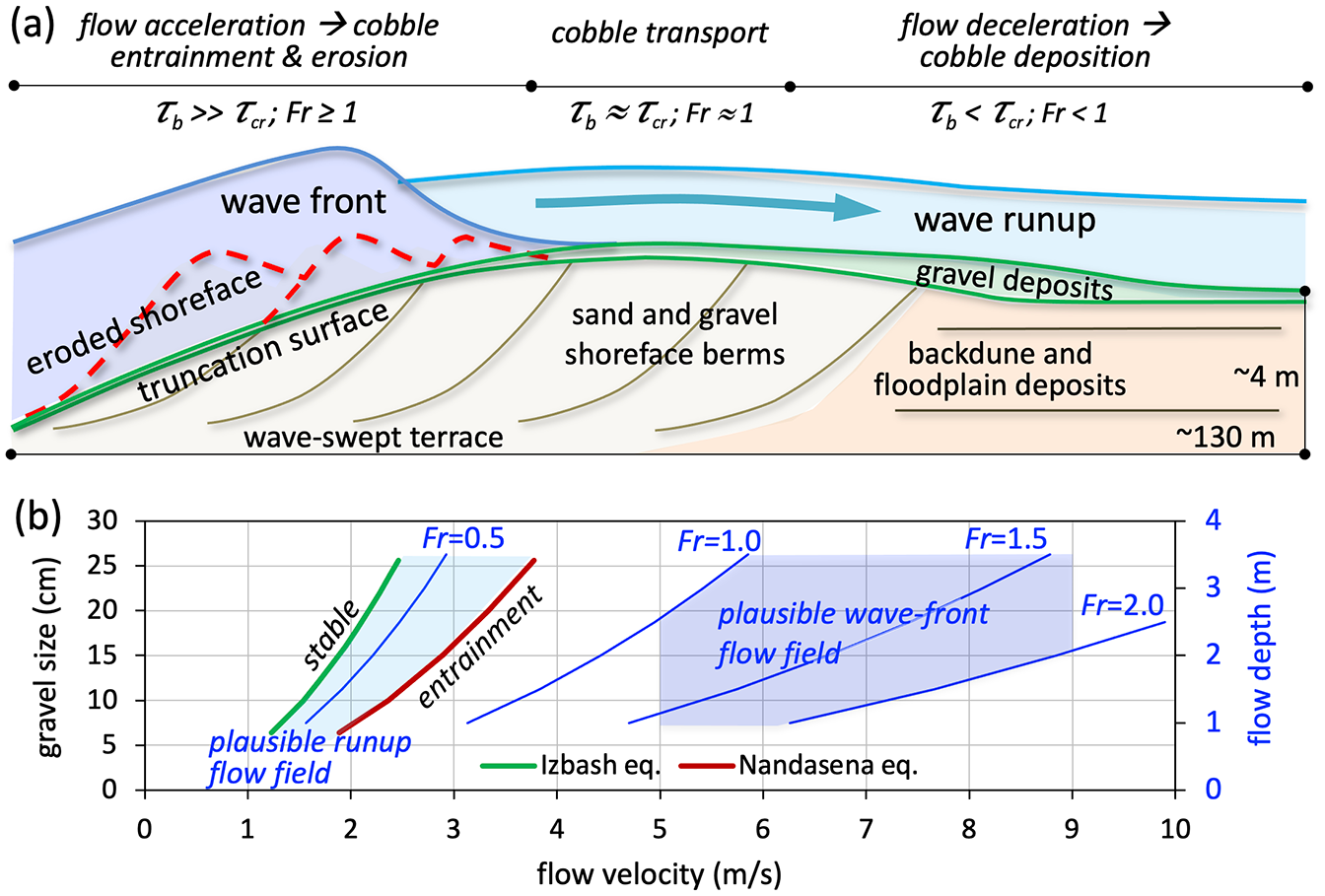
Schematic diagram of (a) the coastal sequence and tsunami impacts with a plot of (b) general flow conditions based on the size and distribution transported gravel. Details discussed in text.
Other important attributes are the distribution of erosion, transport, and deposition defined by the truncation surfaces and gravels deposits. For the fully preserved Deposit A, the first ~50 m from the paleoshoreline are marked by 0.5–3 m of erosion of the shoreface gravel berms, forming the truncation surface (Figures 3 and 8a). This scale of erosion suggests that bed shear greatly exceeded the critical value for entraining gravels across this reach (i.e., τb >> τcr). Over the next ~30 m, where both Deposits A and B are preserved, the surfaces show limited erosion of underlying units and the resulting gravel deposit is only one or two clasts thick (Figures 3d and 4b). These patterns suggest a zone dominated by transport where shear stresses were near the critical value for entrainment (τb ≈ τcr). Beyond these initial reaches, the transport mode shifts to disentrainment and rapid gravel deposition over the next ~50 m of the shoreface, extending onto the adjacent backdune (Figures 4c, d and 5a, b). The thickness of these depositional units decreases rapidly across this zone, with the layers becoming dispersed and intermittent over the latter half (Figures 4d and 5c). These patterns suggest an exponential decay in bed shear (τb << τcr), with no gravels extending beyond ~130 m of the paleoshoreline. The deposits transition into thin sand layers (< 1 cm) that are traceable up to 100 m further inland (Figure 5c and d).
Tsunami-flow inversion models based on gravel transport have not been well developed (Sugawara et al., 2014), and so our study does not tackle a formal flow reconstruction from the Chicama deposits. However, the size and distribution of gravels does allow some useful constraints to be placed on tsunami magnitude and flow. First, the maximum transport distance for cobble-sized clasts (6–25 cm) was ~130 m, with most deposition occurring ~80–100 m from the paleoshoreline. This reach defines the distance over which the critical bed shear (τc) of ~100–200 Pa for coarse cobbles (Berenbrock and Tranmer, 2008) was exceeded during the tsunamis. Furthermore, given that considerable erosion occurred at the leading edge of the truncation surface followed by rapid deposition <100 m away, flow conditions and bed stresses must have evolved rapidly over this distance (Figure 8). If we consider mean flow velocities of 2–5 m/s that are capable of mobilizing coarse cobbles, then the period of entrainment was likely a minute or less (i.e., ~100 m ÷ 2–5 m/s). Given that tsunamis have a wave period many minutes or longer, these constraints suggest that excess bed shear and the entrainment of cobble-sized gravels occurred only during passage of the initial wave front. By extension, the minutes of flow during the post-impact run-up and return drainage appear to have been below the threshold for significant entrainment of the gravels. The ponding of return flow behind the elevated shoreface, at least partially, would have slowed return velocities.
Tsunami attributes
The Froude number relates flow velocity to water depth as a function of shallow-water wave speed, where Fr = u /√ gh, with u = flow velocity, g = gravitational acceleration, and h = water depth. Studies of tsunami flow based on various field, modeling, and experimental observations demonstrate a range of Froude values from 0.6 to 2.0 (e.g., Fritz et al., 2006, 2012; Jaffe et al., 2012; Matsutomi et al., 2001; Moon et al., 2020). These results also show that flow at the tsunami wave front is typically critical to super-critical (Fr ⩾ 1), generating very high bed shear, whereas the subsequent wave runup advances as a subcritical flow (Fr < 1) with considerably lower bed stresses as the ratio of flow velocity to water depth declines. Considering the critical to super-critical flows at the initial wave front, the mean minimum current velocity will be a function of local water depth and can thus be used to constrain minimum wave height. It should be noted that not all (or even most) tsunamis generate bores at the coast; nevertheless, for the Chicama deposits it would be difficult to otherwise resolve the rapid, short-period evolution of the flow field that is needed to generate the intense, localized patterns of cobble erosion, transport, and deposition.
To estimate possible tsunami flow conditions, we compare the stability field for coarse cobbles with the depth-velocity field for subcritical to supercritical flows (Fr = 0.5–2.0) (Figure 8b). We define the threshold for cobble stability (green line) using the empirical Izbash formulation employed by engineers in designing stable channel revetments (USACE, 1958). The boundary for cobble entrainment (red line) is defined by the formulation for boulder saltation developed by Nandasena et al. (2011). For comparison, the mean velocity for a subcritical flow (Fr = 0.5) between 1 and 3.5 m deep falls squarely between these stability and initial-entrainment values (Figure 8b). In contrast, the corresponding velocities for critical to super-critical flows (Fr = 1–2) between 1 and 3.5 m deep all well exceed the threshold for cobble entrainment. Within these constraints, the range of coarse cobbles (12–25 cm) at Chicama would appear to be relatively stable within the velocity fields generated by subcritical flows up to several meters deep (i.e., wave run-up). However, for the same few meters of water depth, critical to supercritical flows that are likely to occur at the wave front would be fully competent to entrain (and erode) the range of gravels at the site.
Taken together, field evidence for rapidly evolving flow conditions and the comparison of gravel-entrainment and flow-field velocities appear to constrain the Chicama tsunamis to a minimum wave height of ~ 2–3 m with the wave front propagating as an energetic bore. Although a larger-height wave (>4 m) advancing as a subcritical flow could also entrain coarse cobbles, such a wave form would generate longer, more uniform flows that would be inconsistent with the clearly localized and non-uniform gravel transport observed here. In all, observations suggests a significant but moderate wave height of a few meters or less led by intense, localized flow at the wave front. While these initial interpretations are provisional, the localized transport of coarse cobbles defines a relatively discrete flow field that must have generated high but short-lived excess bed shear.
Tsunami source and correlations
If our assessment of a modest-height, bore-front tsunami are broadly correct, then these attributes may be consistent with a shorter-period, locally produced wave. Comparable short-period, modest-height wave forms occurred in the 1929 Grand Banks tsunami generated by an earthquake-triggered slope failure along the Newfoundland continental margin (e.g., Moore et al., 2007; Løvholt et al., 2018), as well as the 1998 Papua New Guinea tsunamis that were larger but with a similarly local origin (Davies, 2002; Synolakis et al., 2002). By comparison, trans-oceanic tsunamis will generally have longer periods due to dispersion and are less likely to form bore fronts at the coast.
Along the Andean margin, several studies have explored records of historical and older tsunamis (e.g., Bourgeois et al., 1999; Fritz et al., 2008; Spiske et al., 2013a). Specifically, Spiske et al. (2013a) conducted an extensive search for tsunami deposits in Peru, but most of the recognized events were of historical age and considerably younger than the Chicama deposits. The best candidates for a correlative event studied by Spiske et al. (2013a) include two tsunami deposits from Boca del Rio that were luminescence dated to 1.98 ± 0.23 and 2.26 ± 0.37 ka. Within error, either of these events could plausibly correlate with the 2.0-ka event at Chicama. However, the Boca del Rio site is 1500 km south of Chicama, making a common-cause event generated along the Andean margin unlikely (i.e., a 1500-km subduction-zone rupture). Near Lima ~500 km south of Chicama, Winsborough et al. (2012) also describe two potential tsunami deposits dated ~2.0 and ~2.3 ka at the Pachacamac archaeological site. If correct, the younger deposit could correlate with the 2.0-ka Chicama deposit and Spiske et al.’s (2013a) 1.98-ka event at Boca del Rio. A remotely generated trans-oceanic tsunami would be more likely to account for correlative events along this 1500-km reach of coastline, but the typical form for such long-traveled waves does not fit the flow conditions reconstructed for the Chicama events. Other recent research (e.g., Goff et al., 2011b, 2020, 2022) cites evidence for a possible large tsunami generated in the Tonga Kermadec trench ~2.0 ka, which could represent a potential common source for the ~2.0-ka events at Chicama and Boca del Rio.
For the earlier 2.8-ka Chicama tsunami, there are no published records from the Andean margin that appear to correlate with this event. This suggests that the tsunami was either proximally sourced from a local earthquake and/or slope failure, or else was possibly remotely generated but with the caveat that the Chicama deposit may not be consistent with a trans-oceanic wave. Nevertheless, research in Polynesia presents several lines of evidence for a mega-scale tsunami generated along the Tonga Kermadec trench between 2.8 and 3.0 ka (e.g., Goff et al., 2010, 2011a, 2012, 2022). In all, the field records and age control for Andean to Pacific-scale tsunamis during this time are not yet sufficient for credibly correlating deposits or identifying their sources; however, the possibilities presented here do warrant further consideration.
Archaeological records
The Chicama valley coastline hosts a number of major archaeological sites that record at least 14,000 years of human occupation (Dillehay, 2017; Dillehay et al., 2022). Up to the Mid-Holocene, local cultures were based on a largely maritime economy, supplemented by farming. These Preceramic communities thrived along the Chicama coast, occupying nearshore dunes and wetlands throughout the area. The scale and stability of these communities are exemplified by their progressive, long-term construction of the massive Huaca Prieta mound located 3 km north of the Chicama river mouth, as well as its smaller sister mounds at Paredones and Pulpar, 0.6 and ~15 km further north, respectively. Both mounds lie adjacent to the shoreline and sit atop Pleistocene terrace remnants 6–12 m above sea level with the mounds themselves another 6–25 m tall.
2.8-ka Event and Huaca Prieta
In 1946 and 1947, Junius Bird led a seminal archaeological study of the Huaca Prieta mound as a premier example of preceramic Archaic period construction. Among many important contributions of Bird’s study was being one of the world’s first applications of radiocarbon dating to archaeological materials, work that he conducted in collaboration with nuclear chemist and later Nobel Laureate Willard Libby (Bird et al., 1985; Libby et al., 1949). Concerning the Chicama tsunamis, Bird’s 1948 article titled “America’s Oldest Farmers” (Bird, 1948) describes a sterile cobble layer and disturbed grave on the landward slope of the Huaca Prieta mound. About these features he writes: “At first I thought that the cobble-stones might, for some inexplicable reason, have been spread over the area by people. But after examining them more carefully, I decided that they must have been left by a tidal wave, an opinion that was supported by a similar deposit exposed at the mouth of the Chicama River, two miles to the south. There it was very clear that unusual wave action had carried coarse gravel in from the beach, well above normal storm level and up over soil strata containing evidence of human occupation. This tidal wave, unquestionably catastrophic for the communities near the beach, had little bearing on our problem, for it had clearly occurred some time after Huaca Prieta had been abandoned.” More detailed excavation results related to this event were later compiled by John Hyslop from notes and interviews with Bird (Bird et al., 1985). A third publication by Bird’s son, paleo-botanist Robert McK. Bird, considers possible regional evidence for the 2.8-ka tsunami and postulates considerably broader and more significant impacts on Andean cultures (Bird, 1987).
Based on the new data presented here, the major elements of Junius Bird’s initial interpretations proved presciently correct – namely that a tsunami struck the Chicama coast ~2.8 ka, shortly after the Preceramic era at Huaca Prieta during the mound’s final occupation by the Cupisnique. The mound was later used as a burial site, but the burials were unrelated to the tsunami events (c.f., Cain et al., 2019). Bird’s 1948 article also correctly cites evidence for the tsunami at the Chicama River mouth, to which he attributes his interpretation of tsunami impacts on the Huaca Prieta mound. Beyond these assertions, though, evidence for tsunami impacts at the Huaca Prieta mound remain unsubstantiated, as do the scale of the event and the broader, more catastrophic effects later considered by Robert Bird. A major distinction of our new data is the recognition of two tsunamis, with the younger 2.0-ka event not appearing in prior reports. At the Chicama River mouth, where Junius Bird clearly refers to a truncation surface and gravel deposit, it is actually the younger 2.0-ka truncation surface that he likely noted, as the 2.0-ka surface is fully preserved and would have been the most obvious feature. Missing that two events occurred is understandable, as the deposits are amalgamated along much of the exposure section and distinctions between the two would have been clear only through focused inspection.
Regarding the scale of the 2.8-ka tsunami, Bird purports that the wave deposited a 0.3–1 m thick layer of “sterile beach cobbles” along the mound’s northeastern (lee) flank ~20–25 m above sea level. Indeed this cobble layer occurs at an ideal stratigraphic interval in the mound, lying between the Preceramic and Cupisnique horizons, implying approximate contemporaneity with the 2.8-ka event. Also, given the steep margins of the Pleistocene terrace and the site’s shoreline proximity, it is plausible that tsunami runup may have deflected onto the mound, even for a modest wave height. Less clear, though, is how such brief, chaotic transport might account for the deposition of a thick, highly localized, and elevated unit of “clean” shoreface cobbles. Other locally abundant sediment types include shoreface and aeolian sands, floodplain muds, and the distinctive dark, organic fines (and coated cobbles) of the mound itself. It is difficult to conceive of transporting shoreface cobbles to this leeward, elevated, and discrete section of the mound without incorporating other fractions of sediment.
Dillehay’s (2017) more recent study of Huaca Prieta reexamined the “sterile” cobblestone layer and found that it contained worked stone tools, an intact human burial, and fragments of incised gourds, faunal and floral food remains, cotton netting and textiles, all of which support that the layer was deliberately laid by users of the mound. The two sides of the cobble layer is also slightly beveled as if designed for a ramp or retaining wall and is not of natural origin. The ramp-like structure also is located in the same area of the mound where three vertical retention walls were constructed to prevent erosion of the steep leeward side of the structure (see Bird et al 1985). Moreover, radiocarbon dates from strata below, in, and above the cobble-stone ramp layer range from 4.3 to 3.5 ka, respectively, indicating construction prior to the 2.8-ka tsunami (see Dillehay, 2017: 109–129). These observations seem to favor Bird’s initial conjecture that the cobble layer was emplaced by people (Bird, 1948).
Below the mound and terrace, the tsunami did transport shoreface gravels onto the backdune and floodplain, areas that served as domestic and agricultural sites. Communities during the post-event recovery would have high interest in removing such tsunami-transported debris from these valuable settings. Furthermore, an anthropogenic origin for the sterile cobble layer would be consistent with the absence of any similar cobble unit on other parts of the mound, the surrounding terrace or adjacent Cupisnique mound, or the comparably located Paredones and Pulpar mounds and excavated domestic sites to the north (Dillehay, 2017: Dillehay et al., 2022). In all, we do not find evidence at Huaca Prieta or surrounding sites for the major tsunami impacts first envisioned by Bird and colleagues. There is a similar lack of evidence for the younger 2.0-ka tsunami affecting these elevated terrace and mound locations as well as contemporary Salinar and early Moche fishing villages (ca. 1.8–2.2 ka) along the coast, suggesting that neither event fully inundated them. These reassessments of the archaeological impacts would be consistent with our reconstructions of modest tsunami size and flow conditions based on the rivermouth gravels and truncation surface.
Chicama valley and beyond
Regardless of impacts to the elevated Pleistocene terrace and its archaeological sites, many more people would have lived in the low-lying dunes, wetlands, and nearby floodplains that extend along 30 km of the Chicama coastline. These communities would certainly have been inundated by wave runup during the two events, having an undeniably significant effect on local populations. That said, archaeological evidence along the northern Chicama coast is not well preserved and leaves an uncertain record of occupation for this period from 2.8 to 2.0 ka, which corresponds with the Cupisnique, Salinar, and Gallinazo cultures. One of the most extensive domestic sites (~5000 m2) along the coast is active from 5.5 to 1.0 ka and is located along the backshore, surrounded by dunes (Dillehay and Rosales, 2022). This site’s low adobe and earthen walls would likely have been inundated by the tsunamis, yet the occupation of this and other nearby coastal sites between 3.5 and 1.5 ka indicate that communities persisted in the littoral zone across the period of the two tsunami events.
For the 2.8-ka event that was inferred to have impacted Huaca Prieta, Robert Bird (1987) extends such ideas to consider the potentially broader significance of a major tsunami striking the Andean coast, citing cultural transformations across the region around this time. More likely, though, the timing for such regional-scale changes (i.e., greater reliance on agriculture and inland movement of populations to fertile floodplains) was time-transgressive and not triggered by tsunami-induced catastrophism. The specific examples of damage to infrastructure noted in Bird’s (1987) paper include archaeological sites that are located on alluvial fans lying 40–70 m above sea level, 0.3–6 km inland, and as far south as Lima (~500 km from Chicama; Bird, 1987). While we cannot speak to the veracity of observations from these distal sites, such a scale of impact is inconsistent with observations made along the Chicama coast, both from our study and Junius Bird’s original reports. Furthermore, no evidence for a tsunami of this age or tremendous magnitude has been discovered by more recent surveys of the Andean coast (e.g., Spiske et al., 2013a).
Conclusions
Exposures of Holocene coastal deposits at the mouth of the Chicama River in northern Peru show evidence for two Late-Holocene tsunami events. Observations include a ~150 m-long, low-angle curvilinear surface that cross-cuts gravel shoreface berms at its seaward margin before draping onto paleo-backdune sediments and depositing a rapidly thinning gravel bed. Close inspection of these deposits reveals an older, partially preserved surface indicating the occurrence of two events. Radiocarbon dating constrain the ages of the two tsunamis at ~2.0 ka and ~2.8 ka. Both tsunami deposits are also recognized from limited exposures several kilometers north of the rivermouth, where the curvilinear surface of the younger event and the amalgamated gravel deposits of both events can be seen.
The coarse cobbles comprising the truncation surfaces and gravel units were rapidly eroded and deposited over a distance ⩽130 m. This distribution suggests that the gravels were entrained primarily by the wave front, with limited transport conducted by the subsequent wave runup. An estimation of flow conditions from these attributes suggests a wave height of several meters with critical/supercritical flow at the wave front mobilizing the coarse cobbles but bed shear then decreasing below the entrainment threshold during the ensuing subcritical run-up flow.
Prior archaeological studies suggested that the tsunamis strongly impacted the nearby Huaca Prieta cultural site, a 25-m high mound located on a 6–12 m high Pleistocene terrace. However, the proposed severity of impacts on the Huaca Prieta site are not consistent with the geological and archaeological observations presented here, suggesting that the effects were more modest than previously envisioned. Nevertheless, a tsunami even a few meters high would have severely impacted people living within the low-lying coastal dune systems. Despite immediate peril posed by the tsunami inundations, cultural sites along the Chicama coast do not show evidence of any long-term abandonment. In all, our findings confirm not one, but two, Late-Holocene tsunamis struck the Chicama coast but do not appear to have caused major disruption to the region’s governing powers at the time.
Supplemental Material
sj-pdf-1-hol-10.1177_09596836241297670 – Supplemental material for Record of two Late-Holocene tsunamis along the north Peruvian coast and their relation to archaeological sites of the Chicama River valley
Supplemental material, sj-pdf-1-hol-10.1177_09596836241297670 for Record of two Late-Holocene tsunamis along the north Peruvian coast and their relation to archaeological sites of the Chicama River valley by Steven L Goodbred and Tom D Dillehay in The Holocene
Footnotes
Author Contributions
Funding
The author(s) disclosed receipt of the following financial support for the research, authorship, and/or publication of this article: Funding for this research was provided by the U.S. National Science Foundation (BCS 0914891), the National Geographic Society, Becky and Spence Wilson, and the Vanderbilt University Discovery Research program.
Supplemental material
Supplemental material for this article is available online.
References
Supplementary Material
Please find the following supplemental material available below.
For Open Access articles published under a Creative Commons License, all supplemental material carries the same license as the article it is associated with.
For non-Open Access articles published, all supplemental material carries a non-exclusive license, and permission requests for re-use of supplemental material or any part of supplemental material shall be sent directly to the copyright owner as specified in the copyright notice associated with the article.