
Abstract
A systematic interdisciplinary approach based on the socio-ecological model of the Vienna school has been adopted to achieve a more nuanced and multifaceted understanding of the ancient metropolis of Pergamon (western Anatolia) and its micro-region. The city of Pergamon ranks among the ‘guiding fossils’ of urban culture in antiquity. We describe how the socio-ecological model is subject to adaptation and discussion to fit the needs and circumstances of archaeology. In focussing on geomorphodynamics, we use several approaches to conceptualise and model selected aspects of human-environment interactions, integrating data from physical geography, archaeology, building archaeology (Bauforschung) and ancient history. The model includes several dimensions of the social metabolism of Pergamon, first and foremost the carrying capacity of the environment and demographics, comprising population increase and labour as an active investment in nature. Geomorphodynamics are regarded as major ‘events’ in the model, related to the social metabolism (e.g. increased erosion/deposition in the micro-region in relation to urban sprawl). With the social-ecological model, it is possible – and becomes imperative – to include the perception and representation of human-environment interactions manifested in, for example, administrative patterns and religious practices or architecture and built infrastructure (such as terraces, riverbank stabilisation, substraction terraces and substraction bridges). Geomorphodynamics also involve various aspects of the perception of the environment, though these are not recorded in ancient texts on Pergamon known to date. Concurrently, the importance of the model in organising, structuring, and communicating interdisciplinary collaboration and discourse is highlighted.
Keywords
Introduction
Past human-environment interactions: Geomorphodynamics
Human-environment interactions have attracted increased research attention with the ongoing discussion on the Anthropocene (e.g. Zalasiewicz et al., 2021) and human-induced climate change. Environmental changes during the Anthropocene – at least since the Great Acceleration in the last 70 years (Waters et al., 2019) – have reached extreme and entirely novel dimensions, but have also rendered past human-environment interactions acutely relevant as a research topic (e.g. Burke et al., 2021). In the context of archaeological research, the terms early Anthropocene (Ruddiman, 2003) or Palaeoanthropocene (Foley et al., 2013) have entered the discussion – though not without critical response (Keeler, 2022). As one aspect of past human-environment interactions in the (eastern) Mediterranean, geomorphodynamics (especially soil erosion and flooding processes) have been debated – the discussion went through various stages (Bintliff, 2002) with new case studies, meta-analysis, and methodologies expanding knowledge (e.g. Dusar et al., 2012; Walsh et al., 2019). The debate has long considered the changing contribution of the natural sphere and the cultural sphere to the extent of geomorphodynamicssion, however the actual connection between these two spheres has only recently become a focus (Brown and Walsh, 2017).
For multi-disciplinary research projects on past human-environment interactions, practical and theoretical concerns arise, with the organisation of research being an important issue. For instance, differences in objectives, chronological and spatial precision and resolution, and different concepts of causality and complexity (Haldon et al., 2018, 2019) need to be brought together under a common theoretical umbrella (Knitter et al., 2021).
Aim and outline
The primary aim of the current contribution is to present the socio-ecological model of the Vienna school (Fischer-Kowalski et al., 1997; Fischer-Kowalski and Erb, 2006) as theoretical umbrella for the study of past human-environment interactions. As this model primarily focuses on analysing current ecological issues – but is open to a historical perspective (Fischer-Kowalski et al., 2016) –, we propose an adaption to the classical world informed by findings of studies conducted in the Pergamon micro-region. The focus of the current paper is, thereby, on geomorphodynamics, explicitly including urban physiognomies in the spatial concept of a micro-region (Harris, 2005; Horden and Purcell, 2000; Pirson et al., 2024a; Zimmermann, 2015).
The approach of Daems et al. (2021) focuses on societal metabolism directly rather than on the whole conceptual model of social ecology. Other approaches with a similar explicit trans- or interdisciplinary focus – often with a different emphasis – include for example, ResourceCultures (Scholz et al., 2017), work on consilience by Haldon et al. (2018), and concepts around the nexus between resilience, vulnerability, and sustainability concepts (see, e.g. Butzer and Endfield, 2012; Turner Ii, 2010).
We illustrate how the concept of social ecology can provide a theoretical umbrella for inter-disciplinary cooperation between archaeologists, environmental scientists, ancient historians, and historical building researchers in a long-term project studying the transformation of the Pergamon microregion (Asia Minor/Western Anatolia – today the Aegean Region of Türkiye; Figure 1) between the Hellenistic and the Roman Imperial Period (TransPergMicro) (Pirson et al., 2020, 2024a; see also https://www.dainst.blog/transpergmikro/).
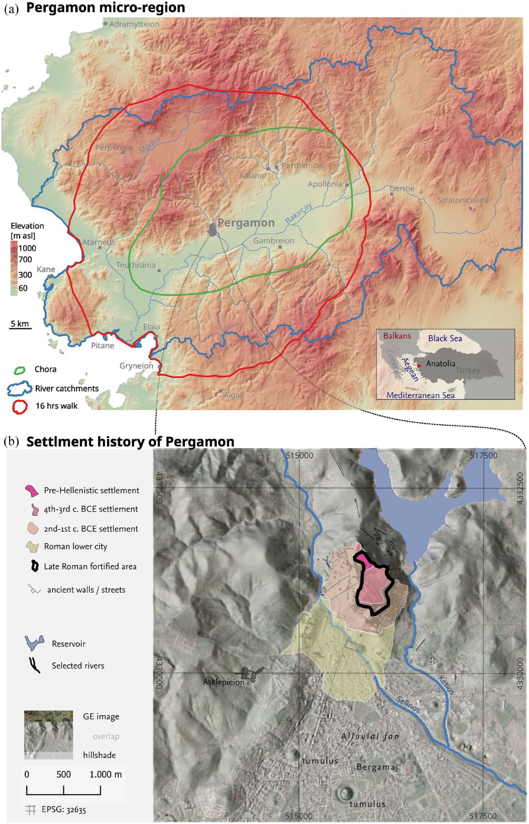
(a) Different concepts of the Pergamon micro-region, based on Laabs and Knitter (2021, reconstructed Roman Chora boundary and a 2-h-walking territory) and Yang et al. (2021, catchments and adjacent coastal areas); background elevation and hillshade: TanDEM-X, 12 m horizontal resolution (Wessel et al., 2018); major archaeological sites according to Ludwig (2020). (b) Extent of the city area of Pergamon. Based on Pirson (2017); hillshade from TanDEM-X.
The case study was a clear review character – after introducing the socio-ecological model of the Vienna School (Section 2) and the Pergamon micro-region as a study area (Section 3), we present the different elements of the socio-ecological model of the Pergamon micro-region as an analytical guideline (Section 4) and describe and discuss how geomorphodynamics can be understood in a socio-ecological way (Section 5) by synthesising the results of different studies conducted mainly between the mid-2000s and 2021.
Social-ecology as a theoretical umbrella for multi-disciplinary research
Social ecology developed as a genuine transdisciplinary research field aiming to overcome specialisation and differentiation in various disciplines working on current ecological issues (Fischer-Kowalski et al., 2016). Not least because of the transdisciplinary character, social ecology can be variously defined (Becker and Jahn, 2006; Knitter et al., 2021). The Vienna School of social ecology (Fischer-Kowalski et al., 2016; Becker and Jahn 2006), point to a common axiom of social ecology, roughly the idea of the interaction and coevolution of natural and social systems (by implication, not the human species). This entails a non-dichotomy of the systems (Knitter et al., 2021) from a theoretical perspective but also from a practical one – different training in different research fields had often encouraged different habitual starting points for research (Light, 1998). The idea of the Vienna school of social ecology is not to completely dissolve disciplinary thinking, but to establish a hybrid sphere between the natural and cultural spheres, that is, a societal sphere. Communication and labour are important connective elements in the hybrid societal sphere, while social metabolism connects the spheres, both theoretically and as an analytical tool. Social metabolism basically refers to the flows of material and energy within and to the hybrid sphere (cf. Fischer-Kowalski et al., 1997; González de Molina and Toledo, 2014) while the cultural sphere includes the conceptualisation and organisation of these flows (which includes their perception and representation). Flows include material and energy to maintain reproduction (endosomatic metabolism); they also encompass economic and cultural practices (exosomatic metabolism, e.g. pottery, materials for cults, buildings, etc.) (González de Molina and Toledo, 2014), a concept that has also been applied to past societies (Daems et al., 2021).
Methodologically, the hermeneutic process of disentangling the flows within the socio-ecological system is based on an interpretation of the landscapes by formulating hypotheses about potential structural couplings of the spheres.
The Pergamon micro-region
The ancient city of Pergamon is viewed as one of the ‘guiding fossils’ of urban culture in antiquity. Research in the last 140 years has drawn a detailed picture of Pergamon as a political, religious, and cultural centre (e.g. Conze, 1912, 1913; Pirson, 2017; Pirson and Scholl, 2014; Radt, 2016).
Pergamon is in western Anatolia, around 25–30 km inland from the Aegean Sea, situated between the wide Bakırçay plain and the Kozak mountains. Today, the city is known as Bergama in the İzmir Province, Türkiye. The ancient city stretched from a promontory, referred to as the city hill, to the alluvial fan of the Selinos (now Bergama Çayı), known as the lower city. The city hill is steep (ca. 25% slope on average), the alluvial fan has a gentler slope (1.5%).
Early traces of settlement on the top of the city hill originate from the Bronze Age; the urban character of Pergamon, however, developed in the fourth century BCE (Pirson, 2017). Under Philetairos (281–263 BCE) and Eumenes I. (263–241 BCE) city walls were built (Figure 1b). Pergamon gained supra-regional importance as it became of the Hellenistic dynasty of the Attalides, who were a major power in Asia minor for a short period in the second c. BCE. Urban planning during this time included incorporating a large, initially unsettled area within the city walls, covering most of the developable slopes of the city hill, which was only built up to a large extent in the first century BCE (Pirson, 2017, 2019; Figure 1b). In the surroundings of Pergamon, several independent poleis existed; during Attalid rule, some of the tows lost importance (Zimmermann et al., 2015), while Elaia, the harbour of Pergamon, flourished (Pirson et al., 2015). With the death of Attalos III, the kingdom was bequeathed to Rome in 133 BCE. The period until the full establishment of Roman Imperial rule under Augustus (27 BCE–14 CE) saw major settlement activities in Pergamon itself, while the urban and fortified settlements in its micro-region witnessed decline or were abandonment (Pirson, 2017; Pirson et al., 2024b; Pirson, 2019; Zimmermann et al., 2015); Pergamon simultaneously became a major metropolis in the Roman province of Asia (Zimmermann, 2011). This development at Pergamon went along with a demilitarisation of the western lower Bakırçay plain, including a reduction in the number of fortified sites (Pirson, 2017; Pirson et al., 2024b). From the late first c. CE onwards, the city area doubled and for the first time (apart from suburban settlements, notable tumuli, and minor burials), the alluvial fan was systematically developed and became part of the urban area. Monumental buildings, as well as residential quarters on the city hill, persisted and were partly developed (Pirson, 2017). Pergamon was the third largest of all cities in Roman Anatolia and the largest inland city (Hanson, 2016). In the late second century and especially in the third century, the urban area significantly decreased in size.
The period between 300 BCE and 300 CE, including the doubling of the urban area of Pergamon from the late first century CE and a spectacular building programme including a theatre, an amphitheatre, a stadium, a huge inner-urban sanctuary, etc. (Pirson, 2017; Wulf, 1994) is referred to as a period of profound transformation. These changes resulted in important consequences and challenges for the socio-ecological system of the micro-region (Laabs and Knitter, 2021), involving resource use, production and consumption, lifestyle and health, architecture and construction, and the design and perception of living spaces (Pirson et al., 2020, 2024a). Consequently, a socio-ecological model of the transformation of the Pergamon micro-region includes complex interactions on different spatial and temporal scales.
The conceptual socio-ecological model of ancient Pergamon: Key terms
Despite around 140 years of research, there are still knowledge gaps in several aspects relevant to understandings of human-environment interactions in the micro-region, for example, the demography of the city and the countryside, Pergamon’s economy and integration in exchange networks, and – more generally – the interaction between the eco-sphere and socio-cultural sphere (Pirson et al., 2024a). Ongoing research in Pergamon aims to address these gaps and achieve a nuanced and multifaceted understanding of these interactions (Knitter et al., 2021; Pirson et al., 2020, 2024a).
The socio-ecological model of the Pergamon micro-region (Figure 2) goes beyond identifying causally interrelated variables in the micro-region or locally defined reconstructions of human-environment interactions. Instead, the relationships between cities, rural settlements, and the landscape are systematically and diachronically examined for the entire micro-region.
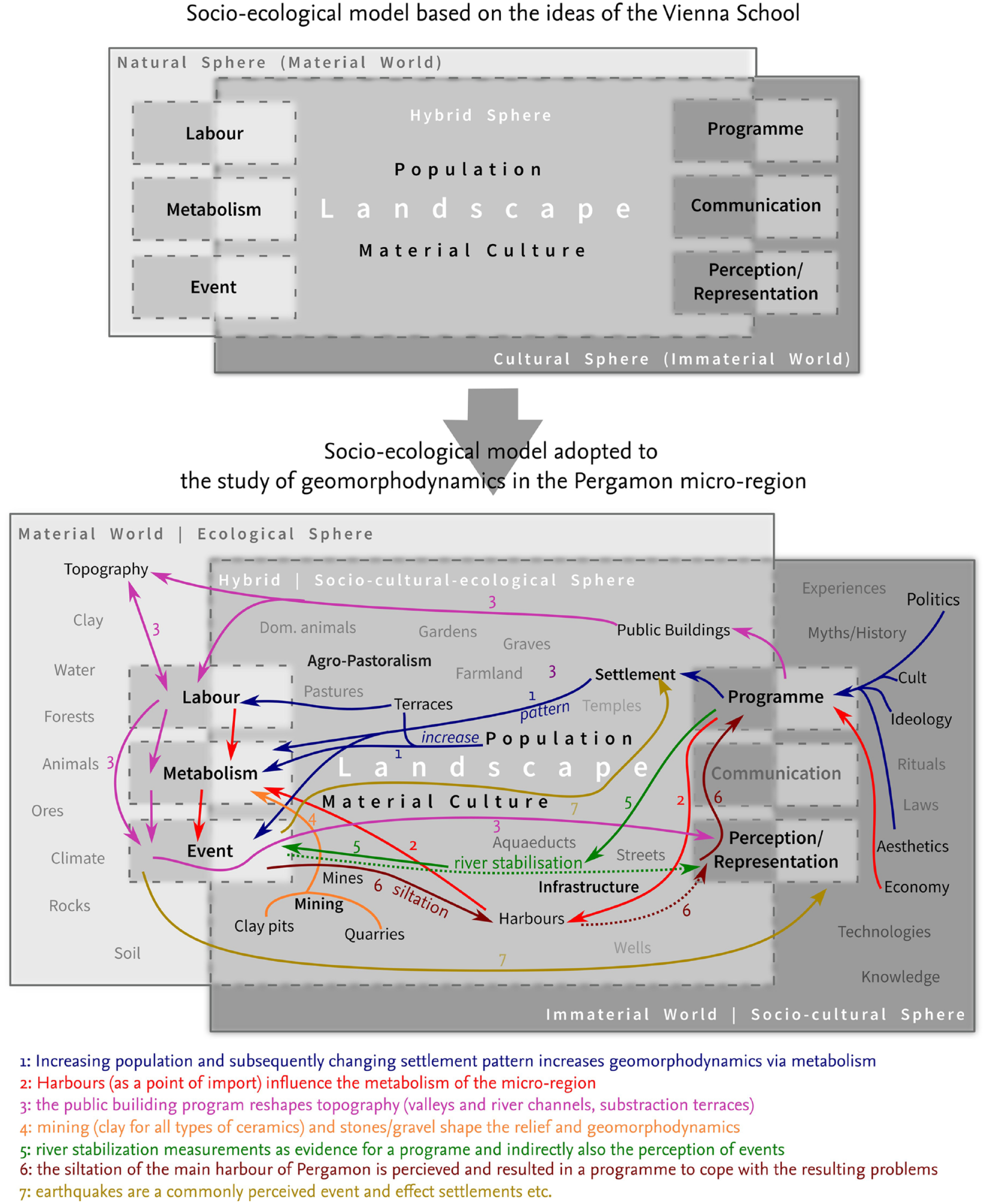
Conceptual socio-ecological model of the Pergamon micro-region; variables and interactions relevant for the current paper are highlighted. Geomorphodynamics are subsumed under the term ‘event’.
The Pergamon micro-region in western Asia Minor is not a geographical unit with clearly defined borders but a space of closely connected and dynamic interactions between humans and the natural environment. The range of such a micro-region can change over time or vary depending on the level of observation for example, political-administrative and military, economic, geographical; Figure 1a). In this respect, a micro-region is both an epistemological and an empirical category (Laabs and Knitter, 2021; Ludwig, 2023; Pirson et al., 2020, 2024a).
The socio-ecological model follows the theoretical basis of social ecology outlined above. The approach considers human societies as part of two separate entities: (a) the
In accordance with the social ecological model of Fischer-Kowalski et al. (1997), society is understood as a communicatively closed but materially and energetically open system. The
A central term of the model is
A socio-ecological perspective on geomorphodynamics in the Pergamon micro-region: Results and discussion from case studies
In the socio-ecological model of the Pergamon micro-region, the term ‘event’ subsumes part of geomorphodynamics including soil erosion and, inter alia, earthquakes; both processes that play an essential role in the settlement history of Pergamon and caused the collapse of several buildings and damaged the water supply system (Garbrecht, 2003; Klinkott, 2000; Pirson, 2017; Wellbrock, 2016). Both, soil erosion and earthquakes, are part of the socio-ecological model, but with different ways of integration: while earthquakes are per se a phenomenon that is caused by processes in the natural sphere, soil erosion is per definitionem a socio-ecological issue, as initially triggered my human agency. Both can, however, be perceived, represented and be part of a programme.
Based on sedimentological data derived from percussion cores and sediment outcrops in alluvial and colluvial settings (Pirson et al., 2020, 2021, 2022; Schneider, 2014; Schneider et al., 2013, 2015; Seeliger et al., 2019; Yang et al., 2023a, 2023b) and a (subsequent) meta-analysis (Becker et al., 2020; Figure 3a), several phases of increased sediment dynamics have been identified for the Pergamon micro-region. Especially at the late–mid-Holocene boundary, sediment dynamics intensified and strengthened during the Hellenistic and Roman Imperial period up to the heydays of Roman Pergamon in the second c. CE (Figure 3a). Downstream of the urban centre of Pergamon, the active lobe of the Bergama alluvial fan shows evidence of increased aggradation rates during the Roman Imperial period and Late Antiquity (Pirson et al., 2021). Increased sedimentation could either be caused by urban development, especially the movement of material during the building process and changing land use in the hinterland – or earthquakes. Additional evidence is derived from built structures on the alluvial fan from the Roman Imperial period which are filled with fine overbank deposits that also cover an actively used surface with macroscopic and geochemical signs of soil formation (Pirson et al., 2021).
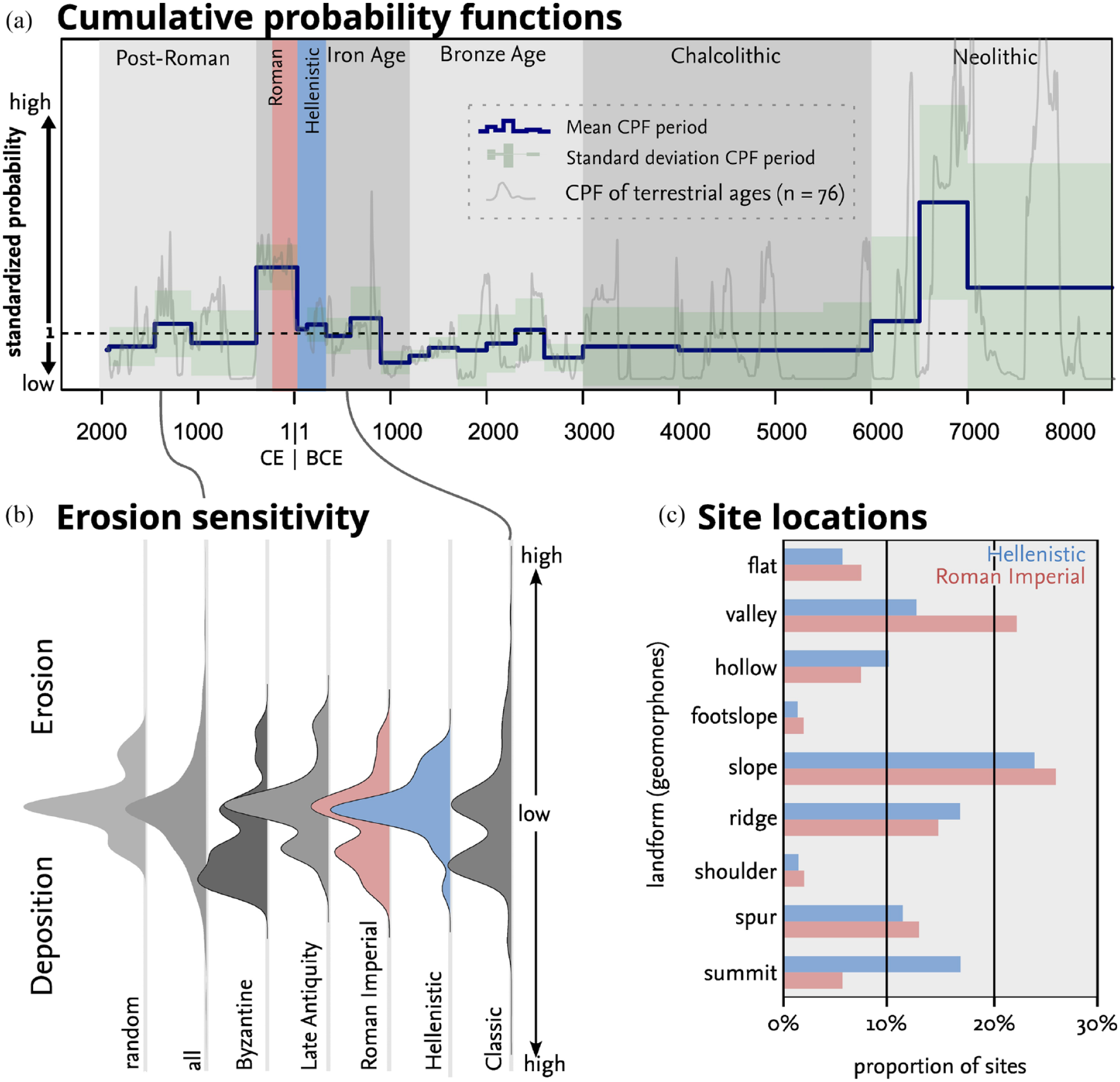
Different approaches on geomorphodynamics in the Pergamon micro-region. (a) Normalised (and summed) Cumulative Probability Functions (CPFs) of terrestrial radiocarbon ages from sediment profiles collected in the micro-region giving an idea of the rate of aggradation during the specific periods. CPFs were calculated by summing the prior likelihoods of 76 calibrated 14C-ages from terrestrial sediment profiles obtained from the Pergamon-micro region. The cumulative probability is normalised against a null model of simulated, equal distributed 14C-age along all profiles (Becker et al., 2020). (b) Diachronic erosion/deposition sensitivity (potential erosion) around archaeological sites in the micro region based on kernel density of USPED results (Unit Stream Power-based Erosion Deposition acc. to Mitasova et al., 1996; model implementation based on Yang, 2023); the USPED model estimates erosion and deposition spatially distributed based on a Digital Elevation Model for transport capacity limited situations with sediment flow having a linear relationship between rainfall erosivity, soil erodibility, land use/land cover factors, and a topographic factor (a function of contributing catchment area and slope); LS: TanDEM-X digital elevation model (Wessel et al., 2018); K based on data from Danacıoğlu and Tağıl (2019); R, P and C = const.; cf. Pirson et al. (2020). (c) Proportion of Roman Imperial and Hellenstic sites found on different landforms (adopted from Pirson et al., 2024b).
Societal metabolism as a trigger of changing geomorphodynamics?
The intensified geomorphodynamics are related to the socio-ecological metabolism in the Pergamon micro-region: urban sprawl coinciding with the considerable spread of the Lower City of Pergamon (Pirson, 2017; Wulf, 1994) and the parallel increase in population in the micro-region that accompanied the change in the settlement pattern (Ludwig, 2023; Pirson, 2017).
The socio-ecological implications for the societal metabolism of the Pergamon micro-region have been modelled and discussed by Laabs and Knitter (2021). The model builds on a fuzzy approach to land suitability for arable farming (Figure 2: 1). In a first step, the area required to cover the caloric needs of the ancient population (i.e. mainly the area for food production) is reconstructed under scenarios of ancient land use (Laabs and Knitter, 2021). The results indicate that the land area available to supply the ancient population was a limiting factor. In the Pergamon micro-region, it would be theoretically possible to supply the assumed population of 180,000 people (Pirson and Zimmermann, 2011) with food. However, a system with such a large population would continuously operate at its upper limits and thus at least at times be dependent on external imports to ensure food supply. A purely Malthusian approach (Bookchin, 2007) assumes that the availability of arable land plays a considerable role in limiting the population. However, as shown by a computational model of the social metabolism of the Pergamon micro-region introduced by Laabs and Knitter, the integration of supraregional exchange networks in the socio-ecological model is essential (Figure 2: 2; Laabs and Knitter, 2021) and thus Pergamon’s harbour at Elaia (Pirson et al., 2015; Seeliger et al., 2019) must be considered as a factor in the metabolism.
Laabs and Knitter highlight that the introduction of and investment in (agricultural) terraces (both regarded as ‘labour’ in socio-ecological terms) is part of the societal metabolism. Terraces thus creating a link from the cultural sphere to the metabolism.
The potential impact of the population increases and related changes in the societal metabolism in Pergamon affected geomorphodynamics – as evident in the sediment record that shows an increase in deposition during the Hellenistic and Roman periods (Figure 3a). However, the relationship between a change in metabolism and increased morphodynamics is not linear and straightforward.
First, most of the settlements in the Pergamon micro-region are located in or along the Bakırçay plain, which is one of the large valleys of the Anatolian Aegean region that follows a graben (Kuzucuoğlu et al., 2019). Thus, fertile agricultural ground (Sommerey, 2008) that is not prone to soil erosion exists in the plain areas and the flood-protected piedmonts of the adjacent mountains (Pirson et al., 2020, 2021; Schneider et al., 2015; Yang et al., 2021). The preliminary analyses of the topographic location of the settlement sites based on (ongoing) archaeological surveys (Laufer, 2020; Pavúk and Horejs, 2018; Pirson et al., 2015, 2020, 2021, 2022; Zimmermann, 2015) indicate a shift in favoured settlement locations from the Hellenistic to the Roman Imperial periods (Figure 3c). In Hellenistic times, locations in elevated areas that are strategically favourable were used for fortified settlements, while plateaus and depressions were preferably used for small agricultural settlements. In the Roman Imperial period, more agricultural production facilities with a higher technical standard (presses etc.) were established, preferably in the piedmont zone and intramountain basins (Pirson et al., 2020, 2021, 2024b; Yang et al., 2021). Also, demilitarisation during the Roman period (Ludwig, 2023; Ludwig et al., 2022; Pirson, 2017; Pirson et al., 2024b; Zimmermann, 2015) and the subsequent construction of leisure facilities in the rural area (villae, thermal bathes; Ludwig, 2022; Pirson, 2017) led to a change in the social-ecological organisation of the micro-region (Figure 2: 1b). This change was motivated by political factors, social inequality, and the needs of Pergamon’s aristocratic elites rather than the societal metabolism (Figure 2: 3; Pirson, 2017; Pirson et al., 2020) – here, a societal programme (part of the cultural sphere) is involved Nevertheless, the change had consequences for the metabolism and morphodynamics: although the land requirements in Roman times were higher than during Hellenistic times, exposure to erosion is overall higher around Hellenistic sites than around sites from the Roman Imperial period (Figure 3b and c). Hypothetically, a change in the preferred settlement area may have occurred – among other reasons – because of soil degradation after ongoing soil erosion (Dusar et al., 2012; Verstraeten et al., 2017). Furthermore, soil conservation measurements might have caused a divergence between metabolism and morphodynamics (Figure 2: 3; Schneider et al., 2013).
Second, the expansion of Pergamon as an urban centre on a steep city hill in the Hellenistic period and the subsequent spread of the city to the alluvial fan of the ancient Selinus (Bergama Çayı) in Roman Imperial times also affected the relationship between settlements and morphodynamics (Figure 2: 4). Morphodynamics in urbanising catchments are somewhat uncoupled from agricultural land requirements (Gregory, 2011; Wolman, 1967), mainly because construction activities leave soils temporally open, exposing them to soil erosion. However, after phases of increased construction activities and increased area requirements due to urban spread, a high rate of impervious surfaces limited the exposure of soils to erosion; while surface runoff increased, it was mainly canalised (Wellbrock, 2016). Due to the location of approximately half of the urban area of Roman Pergamon on a steep hill, substantial groundworks and substraction terraces were required to raise buildings there (Laufer, 2021). This impacted geomorphodynamics, as the groundworks and terraces constitute an intervention in material flows and the relief. The relationship between urban sprawl (i.e. construction) and geomorphodynamics is also evident in the sediments of the currently active lob of the Bergama alluvial fan. Here, a sediment hiatus between Pleistocene gravel (Pirson et al., 2020) and a palaeosoil that developed in massive fine (silty) sands (i.e. the Roman terrain surface) indicates a significant change in morphodynamics. The sediment layers covering the palaeosoil post-date the Roman Imperial period; this fine sediments are also filling a extraurban building that was used in the Roman period (Pirson et al., 2020).
Third, increased exosomatic metabolism requirements might also have affected geomorphodynamics in the Pergamon microregion. The building programme during the Roman Imperial period and the extension of the city into the area of the Bergama alluvial fan (Pirson, 2017) involved a need for vast amounts of clay for tile production, including bricks to build the monumental Red Hall (Brückener, 2018). The growth of the population also increased the metabolic demand for new pottery, thus the need for fuel and clay in the potters’ quarter upstream of the Roman lower city (Bes and Keweloh-Kaletta, 2024; Bounegru, 2003; Japp, 2014) probably affected morphodynamics on the alluvial fan (Figure 2: 5).
Representation and perception of geomorphodynamics
In socio-ecological thinking, ‘events’ like changing geomorphodynamics (e.g. soil erosion) are perceived and represented in the cultural sphere. For the Hellenistic and Roman World, written testimonies are the primary source to reconstruct the political, administrative, and economic framework of human-environment interactions. They provide insights into how contemporaries perceived the ecological sphere, in what terms it was represented in culture, and which programmes guided the exploitation of material resources. For the Greek physician Galen of Pergamon, living in the second c. CE, it was natural to see the Pergamon micro-region as a living organism: food flows from the countryside to the city as from the intestines to the liver – along roads, which are like veins (Hipp. Nat. Hom. 2.6, 15.145 K; Mattern, 2013; Pirson et al., 2024b). The ancient observers – fully aware of how dependent humans were on nature – perceived the relations between the social system and the natural environment as a metabolism, in a similar way to the socio-ecological model of the Vienna School of Fischer-Kowalski et al. (1997). But also changing attitudes towards the natural sphere, reflected for instance by the establishment (and abandonment) of natural sanctuaries in the Pergamon micro-region (Pirson, 2017, in press b; Pirson and Ateş, 2019, in press) or in visual imagery, architecture, and landscape design, are significant and must be included more intensively in future research on human–environment interactions (Pirson, in press a). Knowledge about the cultural sphere in the ancient Mediterranean has been frequently deduced from the remains of material culture. However, ecology does not play a significant role in a majority of the historical analyses (except from e.g. Horden and Purcell, 2000), which usually refer to the socio-cultural, political, religious, and – less frequently – economic backgrounds of architecture, objects and images. However, many ancient texts refer to geomorphodynamics (Dotterweich, 2013). Frequently these descriptions tend to over-generalised by transferring a single observation to another location (Rackham, 1996: 16) and are highly selective; no reports on erosion or flooding as a threat in or around Pergamon have been handed down; texts (Herodotus II, 10; Strabon XV, 1.16) mainly refer rather to aggradation and propagation of the alluvial plains that resulted in the natural reclamation of (fertile) land (Schneider, 2014; Sommerey, 2008). Textual evidence for soil erosion, in addition, does not necessarily indicate that people perceived the relationship between there activities and soil erosion (and thus a problem), but mainly conceptualised soil erosion as a purely natural event (Bosak-Schroeder, 2020). Thus, indirect evidence on the perception of geomorphodynamics is required.
An informative example of the potential perception of soil erosion is provided by the ancient harbour of Elaia, the maritime satellite of Pergamon (Pirson et al., 2015; Seeliger et al., 2019). The port gained importance in the third and second c. BCE and included both a closed harbour and two open harbours, one probably with shipsheds. After the reign of the Attalids of Pergamon (after 133 BCE), the importance of the harbour decreased, particularly in comparison with others in Asia Minor; simultaneously, human activities in the hinterland of the harbour city declined (at least from the second c. CE) The city of Elaia itself ceased to exist only in the late sixth c. CE, paralleled by the complete siltation of the harbours. One of the main reasons for the siltation of the harbours was accelerated soil erosion after tree clearance and increasing pastoralism in the hinterland of Elaia (Shumilovskikh et al., 2016). Thus, the example of the harbour of Elaia sheds light on the direct connection between geomorphodynamics and subsequent human activities. The reaction of the Pergamenian population to siltation indicates also the perception of the socio-ecological event. As dredging – common for harbours in the Mediterranean (Marriner, 2008) – is not evident for Elaia, it is difficult to draw inferences about a socio-ecological programme related to erosion (Seeliger et al., 2019). However, a shipping channel that connected the waterfront of Elaia with the open sea (Pirson et al., 2015) was presumably created after the heydays of the harbour, when siltation started to become an important issue (Seeliger et al., 2019). The reduced transport and trade capacities of Elaia were likely compensated by the development of the neighbouring harbour town of Pitane (Laufer, 2020; Ludwig, 2022, 2023). Located on a headland 9 km west of Elaia, this harbour seems not to have experienced erosion and siltation problems.
Most other known settlements in the Pergamon micro-region are not located directly in areas where off-site effects of soil erosion such as siltation affected people’s livelihoods. The burial of ancient settlements with alluvial sediments might have biased the archaeological record. Some are, however, at least located near depositional areas (Figures 3b and 4e).
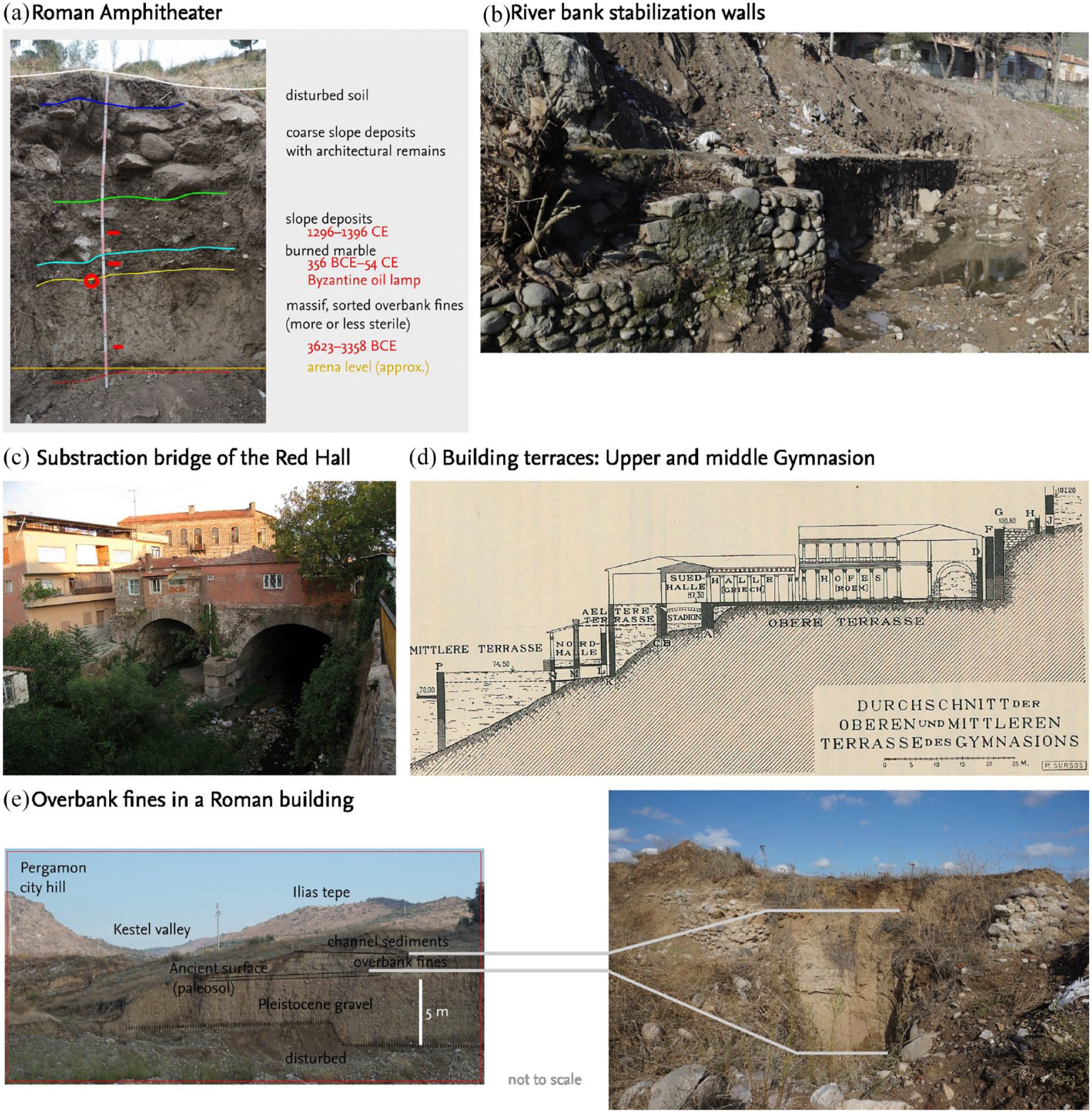
Different examples of the socio-ecological programme and its connection to geomorphodynamics. (a) Late Roman–Early Byzantine sediments above the arena floor of the Pergamon Amphitheatre. (b) River bank stabilisation walls along the Selinus river (Bergama Çay). (c) Example of reliver modificatios (substraction terraces) for public building complexes on the city hill of Pergamon. (d) Substraction bridge of the Red Hall (canalisation of the Selinus river). (e) Simplified sediment profile on the Bergama alluvial fan, below the ancient city; overbank fines buried the ancient surface (left) and filled a potential Roman farm house (right). Sources: FB (a and e), U. Mania, Pergamongrabung (b), Dörpfeld (1907: 196), cf. Schazmann, 1923 (c); Brückener (2018) (d); Pirson et al. (2021) (e).
Programme: Control of geomophodynamics?
Although there is no textual evidence concerning the perception of geomorphodynamic events for the Pergamon micro-region, a socio-ecological ‘programme’ offers indirect evidence for the perception of events – and action undertaken to cope with them. Measures to stabilise the riverbank of the ancient Selinos river in the Lower City of Pergamon (Figure 4b), the substraction bridge of the Red Hall (Figure 4d) (Brückener, 2018; Özis et al., 1979), and road bridges (Conze, 1913) indicate that the Selinos river in the Lower City did not shift its course in the last two millennia, but most likely did before (Brückener, 2018; Pirson, 2017). This allows to assume that the local population observed floods and riverbank erosion (Schneider, 2014). The agricultural terraces mapped for the region (Yang et al., 2021) are probably related to post-ancient agriculture (cf. Koparal and Demirciler, 2024; Turner et al., 2020, 2021). Nonetheless, agricultural terraces might have contributed to Pergamon’s socio-ecological metabolism in antiquity; despite that the construction and maintenance of terraces is labour intensive (Brown et al., 2020), they helped meet demands within the carrying capacity of the micro-region (Laabs and Knitter, 2021).
In contrast to agricultural terraces, building terraces are well-known for ancient Pergamon (Figure 4c), and at least in urban settings (Laufer, 2021) – together with wastewater canals (Wellbrock, 2016) – had a substantial impact on the relief and the geomorphodynamics of the city hill of Pergamon.
Measures against earthquakes were also important to understand geomorphodynamics. From building analysis measures against earthquakes in Pergamon are known, including reinforcement pillars and subsequent ceiling reinforcements (Radt, 1985, 1988). From the Turkish period, it is known that earthquakes were an important factor affecting settlement history, such as the earthquake in 1938 that triggered the relocation of the village of Tekkedere (Yang et al., 2023a). For ancient times, no such evidence for the Pergamon micro-region is available.
Concluding remarks
Many questions on the social ecology of Pergamon are still (and in some cases will remain) unanswered and certain aspects are undiscussed (see Figure 2), both due to a current lack of data and the nature of the data available. Nevertheless, social ecology helps to organise and conceptualise interdisciplinary research on past human-environment interactions. Using the model in a next step diachronically differentiated, it will help to assess the different effects of change processes in the socio-ecologic spheres on geomorphodynamics, and thus landscape (in)stability.
The conceptual socio-ecological model of the Vienna School was mainly developed for case studies on current ecological issues. However, the case of geomorphodynamics in the micro-region of the ancient metropolis of Pergamon shows that the model can be applied to the study of past societies. Besides the knowledge gained on the specific situation in the ancient Pergamon micro-region, the present case study bears some general implications for the use of the socio-ecological concept in the study of ancient societies:
(1) By trying to connect the natural and cultural spheres and their hybrid sphere it becomes clear that knowledge on the three entities is of diverse character. However, integrating these diverse knowledges in a conceptual socio-ecological model reveals connections between individual buildings, settlements and their hinterlands, and the landscape of the micro-region.
(2) The rigid terminological framework dictated by the concept – which certainly is not familiar to all disciplines involved in the presented case study (geography, archaeology, and building research) – entails an advantage. By the exercise of ‘fulling the variables’, the actors in the different disciplines always have to keep the non-familiar aspects in mind.
(3) As the socio-ecological model has no starting point and no predetermined direction of interactions, different disciplines can easily bring in their specific knowledge at any point. For instance, earthquake is an event that act according to the laws of the natural sphere, but the effect on the landscape are only possible with regard to the cultural sphere. Soil erosion, on the other hand, is mainly an event triggered by processes of the societal metabolism, and per se only exists in the hybrid sphere.
(4) Different aspects of geomorphodynamics in the Pergamon micro-region have been observed in recent research. The integration of the different findings into the models shows how they are integrated. Periods of increased sediment dynamics in the hinterland (likely due to increased soil erosion) come together with increasing population pressure which caused agriculture to operate on the limits of the carrying capacity of the micro-region without further investment in terracing. Soil erosion resulted for example, in the siltation of the harbour in Elaia. However, sites in the period of increased pressure where found in locations with lower erosion susceptibility in their surroundings (e.g. in valleys). With urban sprawl, measures were undertaken that prevented erosion and flooding (substraction terraces, bank stabilisation measures). Thus, processes causing increase in sediment dynamics went in different directions. The socio-ecological model here helps to point to the connecting factors of these process, that might be found in the perception of these processes and a programme developed to cope with several issues. However, further research is required to improve the knowledge on these aspects that are less studied than potential triggers or causes of erosion and subsequently increased sediment dynamics.
To sum up, the (adaptation of) the socio-ecological model of the Vienna School provides an integrated approach to the study of human-environment interactions in past societies.
Footnotes
Acknowledgements
Most research was conducted as part of the Pergamon Excavation of the Istanbul Department of the German Archaeological Institute (DAI), for which Felix Pirson holds the licence. We would like to express our special thanks for the kind permission and support from the Ministry of Culture and Tourism of the Republic of Turkey. We also thank the organisers of the workshop in Leuven and the guest-editors of the special issue. The helpful comments of anonymous reviewers that helped to improve the manuscript are acknowledged. Katharine Thomas (Kempen, Germany) gratefully copy-edited the manuscript.
Author contributions
Funding
The author(s) disclosed receipt of the following financial support for the research, authorship, and/or publication of this article: This paper was written as part of the project ‘The Transformation of the Pergamon Micro-Region between the Hellenistic Period and the Roman Imperial Period’; we gratefully acknowledge funding from the Deutsche Forschungsgemeinschaft (German Research Foundation; grant number 419349690). Open Access Funding provided by Freie Universität Berlin.