
Abstract
Three decades of interdisciplinary research within the Sagalassos Archaeological Research Project has provided extensive archaeological, environmental and geoarchaeological datasets. This paper seeks to bring together these datasets to explore diachronic socio-ecological dynamics within the Sagalassos Study Area, SW Türkiye. For this, we will use the Adaptive Cycles and Resilience Theory framework to explore socio-cultural development during changing climatic and environmental conditions. The paper aims to serve as an in-depth case study of these frameworks, integrating archaeological and environmental data, which – despite the increasing popularity of resilience theory – remains underdeveloped within the field of archaeology, especially within Mediterranean and Anatolian archaeology. We will explore the utility of the adaptive cycle framework for reconstructing diachronic human-environment interactions through changing settlement patterns documented during surveys conducted by the Sagalassos Project. Critical phases within the settlement record can be identified during the last 8000 years including apparent periods of ‘rupture’ during the Middle Chalcolithic, Middle-Late Bronze Age, Hellenistic and Middle-Byzantine periods; representing times of serious upheaval in ‘normal’ cultural traditions and lifeways. The adaptive cycle framework will help distinguish between the effects of environmental changes and social dynamics, as well as their potential interrelations in causing long-term social transformation in the Sagalassos Study Area.
Introduction
In this paper, we explore the usage of adaptive cycles to study resilience strategies through the archaeological record. We will evaluate the potential of the adaptive cycle as a heuristic device to structure and interpret archaeological data, to understand the nature, drivers and consequences of socio-ecological change in the past. In line with the interdisciplinary nature of this journal and special issue, this paper focuses on the potential of interdisciplinary cross-fertilization. Every discipline has its own set of heuristic devices – theories, metaphors and models – to build arguments and interpretations that are part of a set of background theories and inform the standard ‘ways of doing and thinking’ (Turner, 2007). We will explore the potential of the adaptive cycle as an ecological concept for studying societal change and stability using archaeological evidence.
Difficulties with operationalization have led the adaptive cycle framework to be dubbed a mere ‘metaphor of change’ rather than an empirically-based explanatory model (Gotts, 2007). This is an important distinction as metaphors and models have different explanatory reaches (Wimmer, 2006). Whereas a metaphor can be applied to a wide range of cases but provides less insight into the workings of these systems, a model can only be applied to specific cases but allows us to narrowly trace system dynamics.
In our case study, we will use the archaeological evidence from the Sagalassos area (southwest Anatolia, modern Türkiye) from Late-Neolithic to Middle-Byzantine times (between 6500 BCE–1200 CE) to develop potential ways forward in the operationalization of the adaptive cycle framework. By looking at settlement persistence in light of apparent periods of ‘rupture’ in settlement systems during the Middle Chalcolithic, Middle-Late Bronze Age, Hellenistic and Middle Byzantine periods we will explore the potential of the adaptive cycle as an empirically based heuristic framework. Despite its growing popularity in archaeology, it remains a major challenge to translate the descriptive nature of the adaptive cycle framework in causal terms. While true system causality remains elusive due to the low-resolution nature of the archaeological record, we will show here how the adaptive cycle can help explore underlying drivers in multi-scalar complex socio-ecological systems.
Theory and methods
Resilience theory and the adaptive cycle
Over the last decades, resilience thinking has attained a central position in the study of socio-ecological systems and human-environment interactions (Berkes et al., 1998; Filatova et al., 2016; Folke, 2006). Resilience theory provides a framework for understanding complex social-ecological systems and their modes of adaptation in light of change and uncertainty. Holling (1973: 14) defined (ecological) resilience as the capacity of (ecological) systems to overcome disturbances while retaining the same populations or state variables. Central to the discourse of resilience thinking is the potential to mitigate disturbance or adapt to stimuli and challenges. Resilience is inherently context-specific given that what makes a system resilient depends on the conditions in which the system operates. A system may be resilient in one context, but not in another. This is a critical feature for the study of long-term resilience in socio-ecological systems.
Resilience has also proven to be an increasingly popular concept in archaeology as the discipline seeks to participate in debates with wider contemporary relevance regarding sustainable development and societal responses to environmental challenges (see among others: Barton et al., 2012; Redman and Kinzig, 2003; Schoon and van der Leeuw, 2015; van der Leeuw, 2019). To implement resilience theory in a suitable heuristic framework for describing and understanding change across multiple scales in social-ecological systems, archaeologists often turn to the adaptive cycle and panarchy framework (Grimm et al., 2017; Gunderson and Holling, 2002; Rogers, 2017; Widlok et al., 2012).
Adaptive cycles describe system dynamics along three main dimensions: (1) potential for change, determining the range of possibilities for system development through accumulated potential (in the sense of physical capital, resources, knowledge, social networks of cooperation, leadership and social trust); (2) the degree of system connectedness; and (3) resilience, measuring vulnerability to unexpected disturbances (Holling and Gunderson, 2002: 32–33). The adaptive cycle describes system trajectories through four phases: exploitation (r), conservation (K), release (Ω) and reorganization (α). The first two phases of the cycle – r and K – respectively, entail rapid initial growth and sustained system conservation and interconnectedness. The Ω and α phases constitute the release of an increasingly integrated system and the associated loss of accumulated potential, followed by the reorganization of the system before entering a renewed r-phase in the next cycle. Together, these four phases describe processes of episodic change in non-linear systems, consisting of a slow buildup of incremental changes and potential accumulation within a basin of attraction from r to K, followed by a punctuated episode of release and reorganization generating rapid system transformation in Ω and α. The r and K phases represent the maximization of production and accumulation of potential, whereas Ω and α entail the maximization of innovation (Holling and Gunderson, 2002: 47).
The adaptive cycle conceptualizes processes of change in human-environment interactions on multiple scales, operating at different rates across several orders of magnitude in time and space, resulting in discontinuous structures exhibiting adaptive behavior (Holling et al., 2002). Any socio-ecological system typically consists of multiple semi-autonomous cycles forming an interconnected hierarchical sequence, called the ‘panarchy’. Individual cycles of comparable size and hierarchical level can also be hierarchically connected across different systems, for example cities connected in interregional urban networks. Across the panarchy, distribution discontinuities can arise endogenously through interactions between cycles and variables operating at different speeds. Smaller-scale cycles tend to move quicker, whereas cycles at the top of the nested system move more slowly. The latter provide stability, permitting lower cycles to pass through Ω and α phases while maintaining overall system functions and keeping the system within the same basin of attraction. Widespread system shifts occur either when lower-level cycles are synchronized through strong interconnectedness and enter the Ω and α phases simultaneously, thus triggering cascades of shifts.
Despite its current popularity in archaeology, challenges in identifying appropriate cycle scales and linking its phases to the empirical archaeological record have led some scholars to question the validity of the adaptive cycle as an empirical framework and call for developing more formal tests of resilience (Riris and de Souza, 2021). While we fully the support the call for more formal approaches in archaeology, we also believe that the adaptive cycle can still prove useful for archaeology. In order for the cross-disciplinary transposition of the adaptive cycle framework from ecology into archaeology to be successful, however, we need to move beyond the mere conceptual description of archaeological observations in terms of cycle dynamics. In other words, we need to go beyond the usage of the adaptive cycle as a ‘metaphor of change’ (Gotts, 2007).
The goal of this paper is to take concrete steps towards the development of the adaptive cycle as a suitable framework for understanding long-term processes operating at discrete scales in a multi-trajectory approach. Elsewhere, we have proposed to consider the adaptive cycle as a high-level (in the sense of highly abstract) epistemological framework that allows to coherently integrate various strands of theory for describing and understanding processes and variables of complex socio-ecological systems (Daems, 2021). To move beyond an abstract descriptive usage, the operationalization of the adaptive cycle in archaeology requires a clear outline of how it fits in a multi-level approach and to which spatio-temporal and social scales individual cycles within the panarchy correspond.
Many applications of adaptive cycles in archaeology make the mistake of directly transposing the framework from its ecological context onto an archaeological case study without proper adjustment it to the empirical situation of the field. In many cases, this boils down to the imposition of new concepts onto existing archaeological phase models (Bradtmöller et al., 2017). To remedy this, we need a contextualized operationalization of the epistemological tenets of the adaptive cycle and match them with the archaeological data. In other words, we need to bridge the gap between theory and data. Harking back to the original usage of middle-range theory as posited by the sociologist Merton (1968), we propose a multi-level conceptual framework by introducing relevant intermediary levels of theory. As we focus here on settlement patterns and economic production in human-environment interactions, we mainly draw from urban studies, ecology, economic theory and innovation studies. We will show how these middle-range theories can be linked to each of the phases of the adaptive cycle. This step-by-step exploration will provide a more detailed explanation of the system dynamics predicted by the framework and offers a clear step forward in the operationalization of the theory.
The r-phase of rapid growth allows the system to quickly spread into available niches and adapt to new states. Niche construction theory states how niche development can be defined as a modification process of a system’s selective environment to the degree that it changes the selection pressures acting upon that system (Riede, 2019). Here, we follow the approach of using this theory outside its ecological context and apply it to social entities (re)shaping their environment (Spengler, 2021). In the r-phase, a large amount of potential allows societies to reshape the environment. To explore what societies do with that potential, we can turn to economic agglomeration theories (Krugman, 1991). As societies increasingly shape their environment, they enhance the flow of energy and resources that can be used to fuel their (economic) goals. Specialization processes can then induce agglomeration economies, driving continued growth and development through increasing returns to scale (Arthur, 1989). Agglomeration economies are key in the generation and accumulation of production surpluses needed for societies to store capital and resources as buffers for future perturbations. However, because of intensification strategies, resource availability decreases and resources tend to get ‘locked up’ over time, meaning they are more tightly controlled. In other words, the cost of getting things done grows higher over time (Walker et al., 2006: 87).
This is characteristic of the transition into K, when system dynamics slow down and the system starts to conserve existing properties rather than explore new avenues of development. The exploitation of energy and resources from the environment is typically subjected to diminishing returns on investment. This requires putting in more energy over time to get the same return output (Tainter, 1988: 194–199). As a result, the overall resilience of the system decreases. Potential continues to accumulate, albeit more slowly and tightly bound to existing structures.
The increased interlocking of system components may induce a pathway of development where a system finds it increasingly difficult to break out of a set pattern, as predicted by the theory of sunk cost effects (Arthur, 1989; Janssen et al., 2003). This forms a rigidity trap in which the system becomes brittle in the face of perturbations (Hegmon et al., 2008). A system may become too rigid or maladapted to deal with disturbance events, leading the potential bounded to the interconnected components to be suddenly released and become lost from the organizational structure. The system then moves into the Ω-phase of release. The process of slow accumulation leading up to an event of rapid destruction has been thoroughly explored through the lens of tipping points (Gladwell, 2000), leading to critical system transitions (Scheffer et al., 2012) through a process of creative destruction (Schumpeter, 1942).
A system going through a release phase can then move towards the α-phase of reorganization. In this phase, connectivity is at its lowest point, allowing uncoupled system components to be re-used in novel combinations induced by the remaining system potential. Innovation theory outlines how innovation potential is at its highest during such phases of modular recombination (Arthur, 2009). The new system may resemble its predecessor when the rearrangement of system components leaves the overall system in the same basin of attraction, or it may attain fundamentally new characteristics in a system that has multiple stable states.
Having outlined all of the phases and their relevant middle-range theories as part of the multi-level theoretical framework, we have now moved one step further in bridging the gap between the high-level theory of adaptive cycles and empirical data. Before we can proceed to the final step by introducing the archaeological data in our case study, it is essential to elucidate which empirical scales the proposed cycles correspond with. The framework developed here builds on earlier work in which we conceptualize the historical trajectories of human societies as emerging from the fundamental building blocks of social interactions and information transmission (Daems, 2021). Going from the fundamental to the emergent, this approach aims to understand how social interactions and information transmission give rise to stability and change in socio-ecological systems. Yet, due to the fragmentary nature of the archaeological record, it is exceedingly difficult – if not impossible – to link the generative dynamics of social interactions and information transmission with the available evidence. This means that we need to think carefully about how we can aggregate lower-level observations for higher-level interpretations and need to elucidate the connections across scales if we want to say anything useful about archaeological phenomena with the adaptive cycle framework.
In physics, this process of relating smaller scales to larger ones is defined as ‘coarse-graining’ (Flack, 2017). This means that processes and objects on levels of lower resolution (in this case settlement patterns and economic production systems) can be described through abstraction from high-resolution levels (i.e. social interactions), but not the other way around. Simply put, it provides a way to understand behaviour at a fundamental level through a coarse-grained (simplified) representation on an emergent level. Coarse-graining inherently causes information loss as its aim is to distil patterns and connections out of seeming disorder. This means that it is a priori impossible to uncover the actual underlying interactions between people by studying past societies. The very process of society formation, going from interactions, over social practices, to structured institutions, inherently involves a degree of coarse-graining through structuration in time, space and social contexts (Daems, 2021: 69–79). Yet, coarse graining also provides a way beyond the messiness of archaeological data by tracing regularities produced by aggregation in the development of social practices and institutions to elucidate drivers of system dynamics and interpret underlying causal factors.
As coarse graining entails the aggregation of information from one level in another, this means we need to identify the relevant scales of analysis, as well as the connections between these scales in our operationalization of the adaptive cycle. The edges of the scalar spectrum considered here are easily defined. On the micro level, we have the generative forces of social interactions and information transmission. However, as we just outlined, this level is not directly accessible to us through the available empirical evidence from the archaeological record. We will therefore only be able to consider this scale through an already coarse-grained lens offered by the most fundamental unit in our dataset: the individual settlement. On the other edge of the scale, the macro level, we have the micro-region of the Sagalassos area as a geographical unit, which for certain periods of time also followed common political and economic patterns (see below).
This leaves the definition of the meso scale as the most tricky but also fundamental part. It has been noted that spatial and social proximities are higher on the meso level, generating higher potential for network development (Rozenblat, 2022). At the same time, the macro level provides a way for weak connections to be generated across more strongly interconnected meso-level clusters. This means that interactions between levels constitute an essential factor of system formation defining the dynamics of the adaptive cycle. In other words, the meso level creates stability and structure for dynamics both on the micro and macro scale, intensifying the generative forces of the former and anchoring the stabilizing role of the latter. Here, we will argue for the role of geographical valley systems as indispensable components acting on the meso scale in the Sagalassos area.
Archaeological data: Surveys and material studies
In this paper we focus on the application of the adaptive cycle as a heuristic framework for describing and understanding settlement systems within the 1200 km² study area of the Sagalassos Project in southwest Anatolia (modern Türkiye) (Figure 1). This spatial demarcation is based in part on administrative choices related to the allotment of study permits by the Turkish government. However, the area also more or less corresponds to the political territory of the city of Sagalassos during Roman Imperial times. This means that at least during part of history, the area can be considered a micro-region in the sense of a clearly defined geographical area following common cultural networks, political structures and economic cycles (Ludwig, 2023). It also means, however, that we will transpose this spatial demarcation into time periods for which this concept was not directly applicable. That said, we believe that the benefits of using a consistent spatial framework for diachronic comparison outweigh the potential downsides.
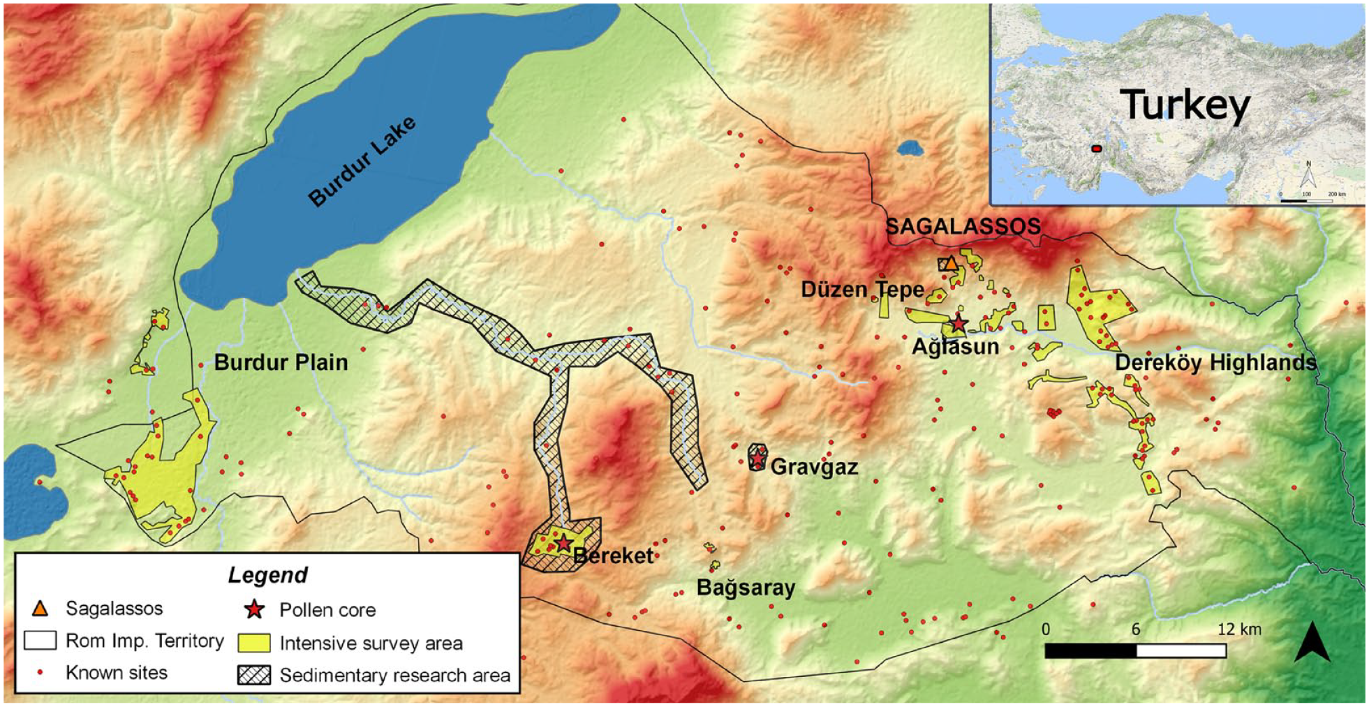
The study area of the Sagalassos Project with location in Anatolia as inset.
Archaeological surface surveys form the primary source of regional archaeological data to study the long-term settlement dynamics within the research area. This type of research aims to reconstruct past human activity by identifying archaeological sites and recording their chronology, nature and size. Throughout its history, the Sagalassos Project has implemented different survey methodologies working on different scales, starting with an extensive survey program in 1993–1996 to document the entire study area, towards intensive survey programs in which small areas were surveyed in great detail (see Vandam et al., 2019a for a detailed overview). Beginning in 2008, intensive surveys have been undertaken in the wider study area with the goal of contextualizing the site of Sagalassos within its environs and facilitating multi-disciplinary synthetic regional research efforts (e.g. De Cupere et al., 2017; Kaptijn et al., 2013; Vandam et al., 2019b). These efforts aimed to sample a wide variety of landscapes within the study area to facilitate a representative depiction of the history of land-use practices. These intensive surveys focused on the intermontane valleys of Bereket (Kaptijn et al., 2013; Vanhaverbeke et al., 2011) and Bağsaray (Vanhaverbeke et al., 2011), the comparably low-altitude Burdur Plain (Kaptijn et al., 2012; Vandam et al., 2013), the highlands around the modern-day villages of Dereköy and Hisarköy near the eastern end of the Ağlasun Valley (Vandam et al., 2017), and most recently in the east and centre of the Ağlasun Valley (Willet and Poblome, 2019).
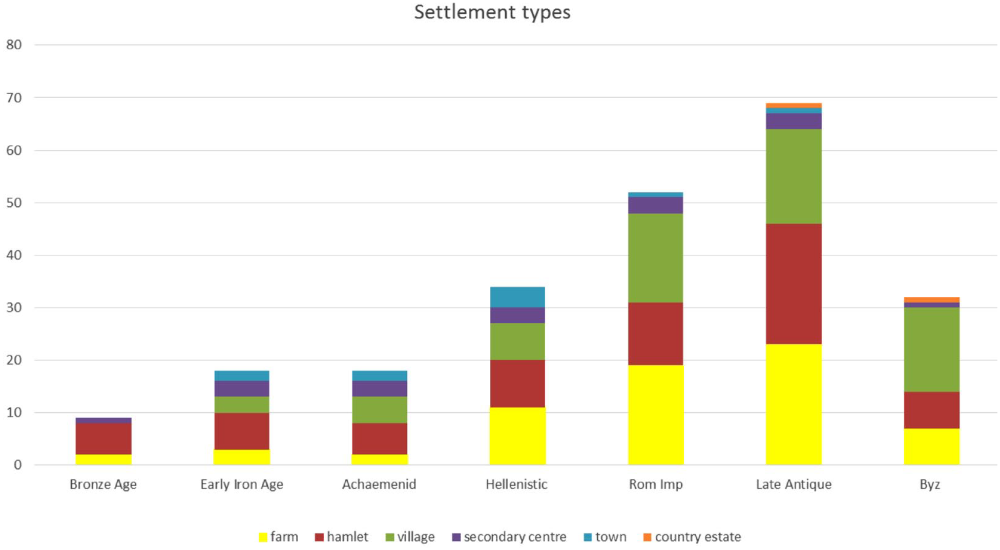
All this research has led to the discovery of more than 289 unique geographical locations with archaeological findings (i.e. pre-dating the Turkish Republic). Several locations show multiple periods of occupation, leading to a total of 704 individual sites. The dating of sites is established by means of architectural standards, inscriptions, tool industries, and most often by pottery determination based on cross-dating methods. The nature of a site is interpreted based on the presence of archaeological features, artefact classes, and locational information. In most cases, a site can be labelled as a specific settlement type. A settlement is defined as an area where a wide range of activities (cooking, artefact production, sleeping, etc.) was performed by people living at the location, leaving a diverse material signature in contrast with special purpose sites such as cemeteries, or sites devoted to other specific human activities like production or rituals. The latter will not be taken into account in this paper. Sites are classified based on their size, following a basic scheme: farm (<0.8 ha), hamlet (0.8–4 ha), village (4–7 ha), secondary centre (8–12 ha and monumental features) and town (>12 ha and monumental features). This distinction is partly based on Bintliff (2000) and further developed for our settlement data. For unexcavated sites – which make up the vast majority of our dataset – site size is determined by the spatial extent of artefacts collected during surface surveys rather than an attempt at estimating the size of the archaeological phenomena at the time of deposition.
The majority of site dating is established through pottery typo-chronologies based on internal typological classification and external cross-dating. The resolution and accuracy of our typo-chronologies are inherently dependent on the amount of material and number of external comparands (as well as the accuracy of these comparands). Reliable typo-chronological frameworks have been established for Hellenistic (Daems and Poblome, 2022; Daems et al., 2019), Roman Imperial and Early Byzantine (Poblome, 1999) times. For other periods such as the Late Prehistory (Vandam, 2014), Achaemenid (Daems et al., 2017) and Middle to Late Byzantine (Vionis et al., 2010) periods, chronological frameworks have been developed that are still in need of more detailed validation. Periods such as the Middle and Late Bronze Age, Iron Age and Ottoman times remain comparatively understudied.
Using the combined evidence from surface surveys and pottery studies, we can establish diachronic patterns of human occupation in the landscape. One important line of evidence is the degree of settlement persistence. Drawing from the integration of archaeology and urban sustainability science, Smith et al. (2021) identified four main dimensions of settlement persistence: (1) occupation, (2) demography, (3) institutions and (4) cultural practices. Settlement duration matters. Settlements with longer durations typically have a higher chance of becoming larger settlements. But duration is not everything. For example, although Sagalassos was the largest and most complex site in the study region until modern times, it is not the site with the longest occupation history in the study area. Two known sites – found close to their modern counterparts Duğer and Dağarcık – yielded materials from at least seven different time periods ranging from the Late Chalcolithic (approximately 4th millennium BCE) to Ottoman times (Vandam et al., Accepted). It remains unknown to what extent the occupation was continuous but at no point did they seem to play any prominent role within the wider area. Nevertheless, as settlements represent the main locus of social, economic and cultural interactions and activities in space, settlement persistence is one of the most powerful proxies available to assess the resilience of past social systems.
The Sagalassos Project has been from the onset an interdisciplinary project with a clear aim of elucidating diachronic human-environment interactions and human impact on the landscape. Extensive palynological investigations have been conducted in three areas in the Sagalassos territory: the Ağlasun valley and the Gravgaz and Bereket basins (Figure 1). These pollen records can provide inferences on the different types and intensities of land use and the concomitant evolution of forested land (Bakker et al., 2012b). Besides pollen, the reconstructive modelling of erosion and sedimentation rates in the Buğduz valley (Dusar et al., 2012) and Gravgaz basin (Van Loo et al., 2017) provides an additional dimension of information. Moreover, recent modelling efforts have focused on uncovering the causal factors in the interplay between past environmental and societal dynamics in southwest Anatolia. (Arıkan and Dardeniz, 2024; Boogers and Daems, 2022). While extensive palynological and geomorphological research has been undertaken, high-resolution direct evidence on past climate remains missing for the Sagalassos area. This data can for now only be derived from sources in wider Anatolia: Lake Nar (Dean et al., 2015), Lake Golhisar (Eastwood et al., 2007), Lake Salda (Danladi and Akçer-Ön, 2018), Dim Cave (Ünal-İmer et al., 2015, 2016) and Kocain Cave (Jacobson et al., 2021). However, clear uniform climate patterns across those data points have not yet been illustrated conclusively (see Jacobson et al., 2021).
Results
The 8500-year history of settlement patterns in the Sagalassos area paints a rich picture of people moving and settling throughout the landscape. The exact reasons behind their locational choices – in other words the drivers of the settlement patterns we observe in the archaeological record today – are not always clear. Yet, a few patterns can be observed which merit further consideration. By integrating the results from pottery studies we aim to enrich the picture painted by the settlement patterns and provide further contextualization to the observed cross-scalar interactions.
General developments within the long-term history of settlement patterns in the Sagalassos area can be found at Vandam et al. (Accepted) but the crucial elements are highlighted here. Clear blocks of consecutive occupations are identified: (1) Late Neolithic-Early Chalcolithic (6500–5500 BCE); (2) Late Chalcolithic-Early Bronze Age (4200–2000 BCE); (3) Iron Age-Hellenistic, (4) Roman Imperial-Late Antiquity (Figure 2). In contrast, there are also clear breaks represented by periods that are poorly represented in the settlement data: the Middle Chalcolithic (5500–4200 BCE), Middle Bronze Age to Early Iron Age (2000–800 BCE) and the Middle Byzantine Period (850–1200 CE).
Diachronic settlement patterns.
Throughout this section, we will describe the patterns observed in the archaeological record and outline how they fit the predictions posited by the adaptive cycle framework. We explicitly opt to combine the description of the archaeological evidence with its positioning within the broader theoretical framework to maximize the explanatory value of the latter with regards to the former.
Starting in the Late Neolithic, the earliest farming communities settled first in the western part of the study area before subsequently emerging in other parts. From the Neolithic to the Early Chalcolithic, and again in the Late Chalcolithic, we can observe a gradual increase in settlement numbers throughout the area (Vandam et al., 2019c). This heralded the start of the settlement system and is taken as the starting point for the adaptive cycles system outlined here. These early developments represent mainly dynamics on the micro level of the individual settlement, rather than the meso or macro scale given that indications of settlement interaction are limited and these are not yet part of an overarching political or economic system. The expansion of communities across available niches is a typical process associated with the r-phase of the adaptive cycle and is well-predicted by the theory of niche formation. Material studies of Late Prehistoric pottery indicated a strong degree of continuity in vessel fabrics and shapes throughout the Chalcolithic and Early Bronze Age (Vandam, 2014). Similar patterns of continuity in pottery fabrics have been observed elsewhere in the Burdur region of southwest Türkiye (Dardeniz et al., 2024). This suggests that individual settlements maintained a fairly steady equilibrium and ensured continued survival within stable environmental pockets in the landscape.
At the onset of the Early Bronze Age (3100–2000 BCE), indications arise of an increasing settlement hierarchy. The site of EB I Hacılar Büyük Höyük (Umurtak and Duru, 2017), located in the Burdur Plain, reaches about 6.7 ha, which marks the first time in the history of the study region that a site surpassed the size of a village (Vandam et al., 2019b). The site itself was incorporated into a dense settlement pattern as it was surrounded by many smaller-sized farms or villages in close proximity, building on the Late Chalcolithic dispersed settlement pattern in which most of the Late Chalcolithic sites were (re)occupied or remained inhabited and grew in size. Along with settlement hierarchies and potentially associated specialization in site functions, material specialization is observed in the EBA pottery through links between specific fabrics and vessel forms (e.g. pithos and bowl fabrics) (Vandam, 2014). In the second part of the Early Bronze Age (after 2400 BCE), however, we again lose material signs of human activity until well into the Iron Age (ninth century BCE).
It can be tempting to identify the observed continuities and discontinuities in the settlement pattern from Early Chalcolithic to the Iron Age as subsequent cycles, each representing the full set of phase transitions from r to α. The observed increase in site sizes and potential settlement specialization as part of a process of settlement hierarchy formation, could in this regard be interpreted as a shift from the r-phase to the K-phase, which then proved unsustainable and induced a rapid shift through Ω towards α. We should stress, however, that a system need not pass through all phases of the cycle, and not necessarily always in the same order (Aimers and Iannone, 2013: 26–27). For example, if a given system cannot sustain existing levels of development induced during an r-phase or is faced with an unexpected situation of such a magnitude that it exceeds the level of control for existing system structures to cope with, the system may jump directly into the α-phase and reorganize due to these new selection pressures.
Although the period discussed so far comprises the so-called 4.2. Ka event, this disturbance has not been identified in different paleoclimate proxies within Anatolia (including the close-by Kocain cave, 60 km south of the study area, see Jacobson et al., 2021). Pollen records from these periods are also very scarce, which is why it is hard to asses to what extent climatological or environmental change occurred during this period. This does not exclude the possibility of individual settlements impacting, or even changing, their own ecological niches through extensive exploitation of their immediate catchment areas, but for now, no evidence exists to support this hypothesis. To exacerbate the situation, the strongest limiting factor of our understanding of the area is not only the lack of paleoclimatic information, but also that of settlement data. Whereas elsewhere in West and Central Anatolia widespread shifts in the settlement system are observed during the Middle and Late Bronze Age (Massa and Şahoğlu, 2015), the material record of these times is remarkably sparse for the Sagalassos area. It cannot be excluded that we simply do not recognize the relevant material in our survey assemblages given the lack of reliably dated stratigraphic datasets that can be used as ‘index fossils’.
We pick up the signal of human presence again at the turn of the first millennium BCE. The settlement pattern at this point seems oriented towards a series of sizeable hilltop sites (Figure 3), often with defensive fortification structures (Vanhaverbeke et al., 2011). With an average size of about 8ha, these sites exceeded even the largest Bronze Age site of Hacılar Büyük Höyük. It has been suggested that these sites were self-subsistent communities focused primarily on their immediate hinterland in the surrounding valley systems for the majority of their subsistence needs (Daems et al., 2021). A combination of macroscopic pottery studies with geochemical and petrographic analyses have suggested that these hilltop communities operated within a locally-oriented economic landscape (Braekmans et al., 2017; Poblome et al., 2013). This entails the predominant usage of raw materials derived from the immediate vicinity of the site, as well as a production output geared towards supplying the local community. Despite the strong reliance on the local environment for their subsistence needs, recent modelling efforts showed that these communities were able to sustain themselves for a prolonged period throughout Iron Age and Achaemenid period (Boogers and Daems, 2022).
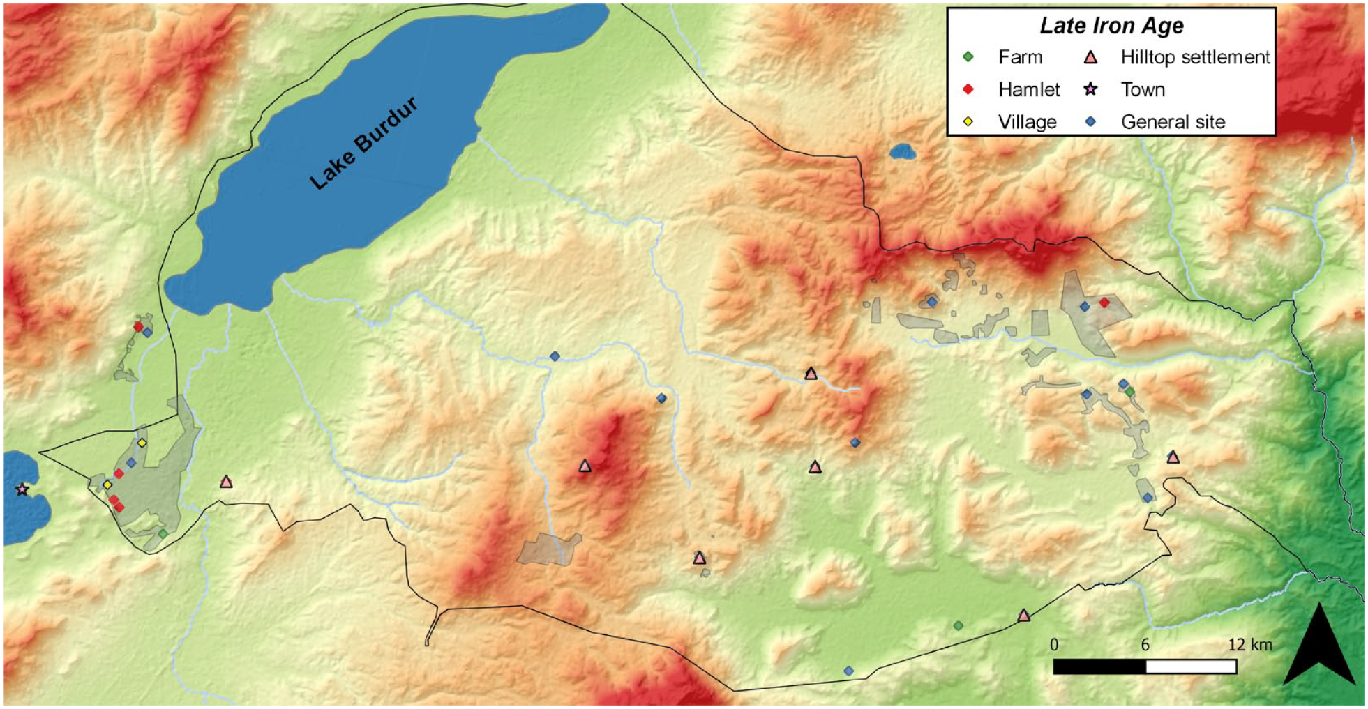
The Late Iron Age settlement pattern.
However, in doing so these communities also acted as significant drivers of local environmental change. The pollen data from the study area identified the Beyşehir Occupation Phase (BO-Phase) as an important disturbance event from 1000 BCE onward (with the onset showing some variation between different valleys in the area, see (Bakker et al., 2012a).The BO-Phase is a period of anthropogenic activity characterized by forest clearance, crop cultivation, arboriculture and disturbances, and is observed in large parts of the eastern Mediterranean (Eastwood et al., 1998). During this period a double-peak of arid conditions (1150 and 800 BCE) has been observed in the Kocain speleothem data (Jacobson et al., 2021). The onset of marked anthropogenic impact on the landscape in the Iron Age had no immediate impact on the prevalent settlement system but gradually subverted the resilience of the landscape. Geoarchaeological research indicated that the geomorphic system in the Sagalassos study area became most active during the Iron Age (1150–546 BCE, (Dusar et al., 2012). The increase of human activity on hilltops was accompanied by large-scale land clearance (Bakker et al., 2012b: 258–259). This resulted in high erosion on the hillslopes and high sedimentation rates at colluvial and alluvial locations, strongly shaping local environmental niches and potentially reducing the suitability of the higher areas for human occupation (Broothaerts et al., 2019; Van Loo and Verstraeten, 2021; Van Loo et al., 2017). The gradual loss of resilience in certain areas of the landscape eventually resulted in a marked shift in settlement patterns during the Hellenistic period (323–25 BCE). In this period, communities across multiple valley systems started to diversify into other local niches, most notably shifting away from the hilltop and hillside areas towards the valley bottoms (Vandam et al., 2019b).
During the middle Hellenistic period (200–100 BCE) Sagalassos emerged as the primary urban entity and the main political and economic centre in the area (Daems, 2019; Poblome et al., 2013). The lack of sites dated to the Middle and Late Hellenistic period in the surrounding Aǧlasun valley suggests that one of the main drivers of this urban boom was a process of demographic nucleation, pulling population towards the urban centre (Daems and Talloen, 2022). At this point, the community also established political control over most of the study area (Waelkens, 2004) and started to operate in an extended productive landscape, increasingly targeting high-quality raw materials from beyond the own catchment area (Poblome et al., 2002) and distributing its material culture beyond the own community (Daems et al., 2019). Processes of political centralization and economic specialization continued and even intensified during Roman Imperial times when Sagalassos became a prominent urban centre within the region of Pisidia and a centre of tableware production whose wares reached markets across the eastern Mediterranean (Poblome, 2014, 2015).
Across the full settlement history in the study area, the largest and most complex settlements fall within the Iron Age to Roman Imperial timespan. The emergence of large fortified hilltop sites and the way they reshaped their environmental niche during the Iron Age and Achaemenid periods represents a shift to the K-phase on the micro and meso level. The subsequent diversification of niche exploitation in early Hellenistic times represents a rapid transition from K to Ω and α on the same micro and meso levels, while also initiating the onset of the r-phase on the macro level. The emergence and continued development of Sagalassos as primary urban entity and central political and economic centre represents the shift towards the K-phase on the macro level of the study area. During the Roman Imperial period, the settlement pattern became increasingly oriented towards a more specialized exploitation of available resources throughout multiple valley systems, and the re-funnelling of resource and capital flows towards Sagalassos (Poblome, 2015). It is also at this time human impact started to peak (Bakker et al., 2012a), coinciding with favourable climate conditions induced during the Roman Warm Period (as picked up by regional paleoclimate proxies), which allowed intensified agricultural activities in these remote and higher situated valleys.
Supported by increased specialization and connectivity on the local level and taking advantage of increasing returns to productivity generated by higher connectivity on a regional and inter-regional level, Sagalassos was able to use the potential offered by the Roman integrated market to fuel its own urban development. This period of unparalleled economic and urban growth is generated by the synchronization of the K-phases across multiple cycles. Economic surplus and potential generated by this pocket of ‘Smithean’ growth sustained a process of gradual population increase throughout the Roman Imperial and Late Roman periods (25 BCE–400 CE) (McCormick, 2001: 31). This population growth can be observed through the boom of sites dated to these periods in the Sagalassos study area, especially in the rural areas, see Figures 2 and 4). In the Late Antique period, in addition to the existing production of terra sigillata tableware, new lines of pottery production were launched, including amphorae, oil lamps, figurines and wine flasks, indicating an increased diversification of the production system (Poblome, 2015: 126). In the eastern Ağlasun Valley the arable lands in the highlands became cultivated during this period (Figure 4), in contrast with the Roman Imperial period (Vandam et al., 2017, 2019b). The many locally produced amphorae fragments and (counterweight-and-screw) presses identified at the sites indicate that these communities were engaged in (small-scale) wine/oil production. For the Bereket valley, even though the settlement data remained stable, the pollen data showed a disappearance of intensive crop cultivation during the Late Antique period, while open steppe and juniper/evergreen oak maquis became much more important (Bakker et al., 2013: 82). These vegetation types are often interpreted as resulting from heavy overgrazing by sheep and goats (Vermoere, 2004). This all has been interpreted as a specialized focus on pastoral activities (Kaptijn et al., 2013: 89–91).
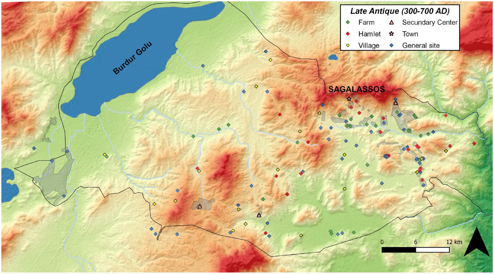
The Late Antique settlement pattern.
The observed increase in specialized niche production can be considered part of a broader strategy towards a more robust economic system to provide a stable foundation for dealing with increasing aggregate demand and increased per capita income generated by population growth (Poblome, 2015: 139). These strategies allowed a stable equilibrium to be struck between energetic needs and ecosystem capacities throughout the Late Antique period. Yet, the precarious balancing act needed to maintain K-phases across multiple cycles ultimately eroded the long-term resilience of the region. The growing dependency on production specialization geared towards wider market during the preceding Roman Imperial period resulted in an increasing portion of the potential of the local area being re-directed beyond the regional macro-level and reducing resilience to shocks. One such a shock occurring during the Late Antique period could have been the Justinianic Plague, striking first in the middle of the 6th century CE, which could have induced a transition towards the α-phase of system reorganization. Also abrupt climatic changes such as the Late Antique Little Ice Age (536–550 CE) could have contributed to this, even though again there is no uniform picture across Anatolia.
The disparate signals across multiple valley systems described above show how the transition away from K can induce multiple strategies on the micro and meso level. The explanation for this multiplicity on the micro and meso scales can be found in the disruption of the overarching macro cycle when Sagalassos lost its urban pull over the wider territory during the transition into Ω. The cycle operating on the macro-level of the study area thus no longer provided a stabilizing factor for developments on the lower scales. This allowed cycles on the micro and meso scales to skip Ω and transition directly towards the α-phase of reorganization. As a result, each of these valley systems again fell into its own rhythm, seeking its own conditions and properties suitable to the own environmental niche, comparable to the situation in pre-Hellenistic times.
During the Byzantine Dark Ages a clear decrease in site numbers is observed in some parts of the study area. Also in the pollen data we see clear decrease in anthropogenic indicators (Bakker et al., 2012a). During the Middle Byzantine period Sagalassos regained some of its regional importance as a kastron (fortress) and bishopric exercising certain administrative, military and religious functions (Poblome et al., 2017). The clear drop in settlement numbers in the Aǧlasun valley surrounding Sagalassos suggests a renewed nucleation process towards the city (Daems et al., 2021: 598). This renewed urban pull does not seem to have reached across other valley systems in the area where the settlement pattern remains centred on the continuous habitation of a limited number of larger villages (Figure 5).
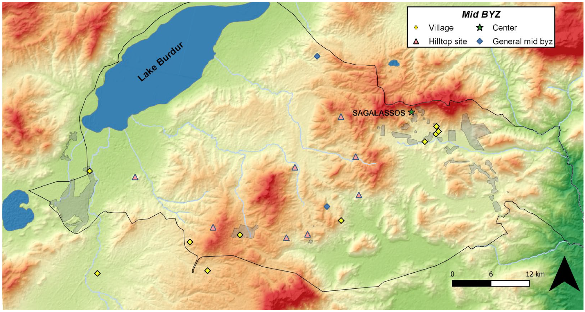
The Middle Byzantine settlement pattern.
This local development can be seen as part of a broader conversion process during Late Antiquity and the Byzantine period in which the main unit of communal organization in many parts of the Mediterranean world shifted from cities to villages (Poblome, 2014). While we should be careful to revert to the trope of societal collapse following the disintegration of the Roman empire (see for example Humphries, 2019 for a recent reappraisal of urban dynamism in Late Antiquity), the reduction of the pulling force of urban centres seems to be confirmed for the mountainous and relatively isolated region of Pisidia. The reduced reach of Sagalassos does not imply descent into isolation. The pottery found at the site suggests a certain degree of connectivity across southwestern Anatolia through morphological parallels and imports (Poblome, 2014). Sagalassos also remained the bishopric of the area, with its bishop mentioned in several records as participating in synods and ecclesiastical councils (Belke and Mersich, 1990: 368–369). However, it does suggest that the conditions needed to create the overarching cycle on the macro level centred on Sagalassos as the main urban hub were no longer present, bringing the system back to an equilibrium state on the micro and meso scale, centred on individual settlements operating within single valley systems.
Discussion
In earlier work we developed a preliminary outline for the application of the adaptive cycle framework to the Sagalassos area (Daems and Poblome, 2016). The current study builds on this work and provides the first attempt at integrating a long-term perspective on the interpretation of both settlement patterns and material studies in the study area of Sagalassos through the adaptive cycle framework. The long-term perspective applied here has the advantage of allowing proper contextualization of communities in their local environment. The usage of the adaptive cycle framework allows us to assess whether observed changes represent phase transitions within an existing cycle or ruptures in system dynamics that can be equated with the initiation of a new adaptive cycle (Figure 6). This way, we can build better understanding of the causal patterns underlying these changes.
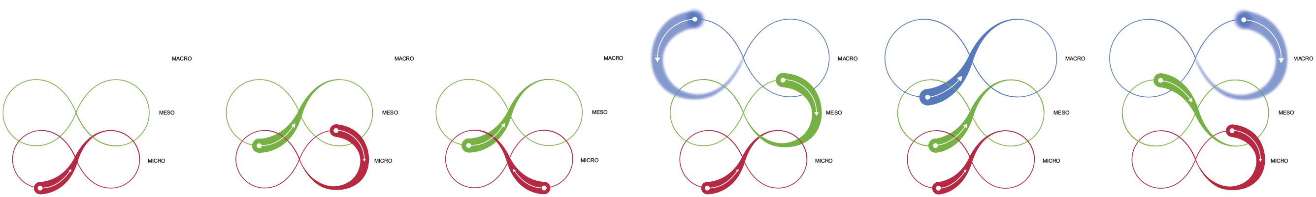
Multi-scalar adaptive cycles for the (from left to right) Neolithic-Chalcolithic, Early Bronze Age, Late Bronze Age-Early Iron Age, Iron Age-Hellenistic, Hellenistic-Roman and Roman-Byzantine periods.
The element of scale is essential here. A phenomenon that can be considered a phase transition at one scale of analysis may be considered a full system state flip at another. To identify change as a major disruption versus a minor perturbation within a consistent phase trajectory, we must assess ‘whether the unit of analysis has maintained the structures, controls and members that are considered essential to its identity, and on what intersection between temporal, spatial and organizational scales these changes developed’ (Daems, 2021: 114). While the multi-scalar adaptive cycle framework provides the ideal conceptual tools to do so, establishing empirical validation is a more difficult matter.
If we look at various episodes of niche exploration in long-term settlement patterns, that is, the spread of new sites in previously unoccupied parts of the landscape, then we see this process featuring prominently in the Chalcolithic, as well as the Hellenistic and Roman Imperial period. As highlighted above, niche exploitation and exploration can be considered typical processes in the r-phase of an adaptive cycle. However, for both periods, this process plays out on different scales. For Prehistoric times, niche exploration occurred mainly on the micro level, whereas for the Hellenistic and Roman Imperial periods this was part of the process of landscape specialization and intensification of exploitation in function of the ongoing transition towards the K-phase on the meso scale.
Looking at this evidence from the perspective of settlement persistence, this suggests that adaptive cycles on the scale of the individual settlement maintained their equilibrium for a prolonged period of time. In this paper, we equate this level with the micro scale of analysis, meaning that we do not zoom in on intra-site dynamics. This does not mean that rapid release and reorganization transitions did not occur on lower scales - for example on the level of social groups or households - to sustain this equilibrium. It merely means that the archaeological record does not allow us to say anything with a reasonable degree of probability on what might be happening there. On the other hand, it also suggests that at least one dimension of settlement persistence – persistence of occupation - can be a factor of resilience in transitions towards new adaptive cycles, even if this does not necessarily imply persistence of demography, institutions, or cultural practices. For example, the integration into the Roman Empire resulted in profound changes in the institutional and cultural framework of existing urban centres (Verboven, 2021). The superposition of a new level of urban pull from Sagalassos as the new political and economic centre instigated a transition phase towards a new cycle throughout the region and provided new opportunities on all levels.
Zooming in on the emergence of Sagalassos as the main urban centre, we can use the adaptive cycle framework to explore this process as a system of ‘superimposed rhythms’ of change, in which faster dynamics of social units operate against a backdrop of slower environmental dynamics as part of a complex integrated spectrum of social, biological and ecological rhythms (McGlade and van der Leeuw, 1997: 338–339). It is clear from Figure 6 that the late Hellenistic and Roman periods (the fifth element in the figure) constituted the only time period where a clear synergy in cycle phases (transitioning from r into K) occurred across multiple scales, thus facilitating the observed urban and economic development.
One ‘translation’ of these slower background cycles in social terms can perhaps be found in the occurrence of small-scale farming settlements, which constitute the majority of settlements throughout all time periods. It is tempting to interpret these smaller farming settlements as an element of continuity and stability. However, we see that small-sized sites rank highest on the scale of instability, that is, they have more disruption phases, occupation durations are shorter, and their locations shift throughout the landscape more frequently. Here, we might be scratching the surface of an even smaller-scale cycle, that of choices made on the level of individual lifespans or small families. On the meso and macro scale, however, these small-scale sites represent a strong foundation that Sagalassos was able to tap into to draw the necessary energy and resources to fuel its emergent urban transformation during the Hellenistic and Roman periods.
At the same time, we see a clear shift from hamlet-sized occupations (1–3 ha) towards farms (0–1 ha) and villages (4–7 ha) during the Roman Imperial, Late Antique and Byzantine periods (Figure 2). In other words, the intermediate level of settlements was lost in favour of larger entities that provided a more intensified approach to land use management and exploitation. This can be seen as an additional strategy to sustain the K-phase on the meso and macro level, in which a rapid succession of Ω and α results in the initiation of a new adaptive cycle on the micro level. This is a good example of how Ω need not necessarily entail overall system collapse. Instead, it is a reminder that its effects must be considered on the relevant scale.
Our long-term perspective shows that Sagalassos was an urban ‘anomaly’ in the long-term history of settlement patterns in the area that is only possible when multiple cycles across scales are synchronized towards the K-phase to unlock the local potential and create sufficient aggregate demand on higher scales to tap into this potential. This required a concerted effort that ultimately eroded the long-term resilience of the region, resulting in a return to the previous state centred on the ‘background’ rhythm of socio-ecological dynamics on the micro scale and meso scale.
Conclusions
The adaptive cycle offers a rich conceptual framework that has found numerous archaeological applications in recent years. Yet, its empirical value as an operational and rigorous framework has been questioned as well (Riris and de Souza, 2021). We opened this paper by highlighting the difference between metaphors and models in scale and explanatory power. It should be clear at this point that proponents of either end of the spectrum are both wrong. The adaptive cycle is neither a metaphor nor a formal and rigorous model. Yet, that does not mean it is without merit or lacks potential for future studies.
In this paper, we have outlined a potentially fruitful approach by integrating the adaptive cycle in a multi-level theoretical framework. Even though the dynamics of the adaptive cycle itself have not (yet) been defined in formal terms, it provides an overarching framework that allows us to link a series of intermediate-level theories, many of which have been formally and rigorously defined in their own right. We then showed how this multi-level framework can be used to explore underlying drivers of system change observed in empirical archaeological data. We believe that this approach offers a realistic way forward for the continued development of the adaptive cycle framework as a valid model of multi-scalar socio-ecological change and stability in the past.
This end goal is a work in progress and much more remains to be done. To improve the operationalization and application of the adaptive cycle framework in archaeology, we need to:
(1) Find correlating drivers of change in ecological and social systems, especially for the transitions between cycle phases.
(2) Identify a set of predictions for the model and each of the phase transitions.
(3) Explicate the role and meaning of cross-scalar interactions.
(4) Identify relevant proxies for each of the three parameters (potential, connectedness and resilience) in the adaptive cycle.
(5) Redefine the adaptive cycle in terms of concrete flows of energy, resources and information as a potential way forward in formalizing the framework (see Daems, 2021).
The road may be long and winding, but the destination could be beautiful. A successful operationalization of the adaptive cycle would provide a powerful additional tool for understanding the deep history of human-environment interactions and long-term changes in socio-ecological systems. Better understanding of the deep past, in turn, offers a huge step forward in understanding the genesis of present dynamics of climate change, ecological resilience and human adaptation. By contextualizing the present in the past, we can help drawing the outlines of a roadmap towards a better and more sustainable future.
Footnotes
Acknowledgements
The authors would like to thank all members of the Sagalassos Archaeological Research project who contributed to the years of data collection on which this paper is based. Special thanks and credits to Nina Troosters and Jeff Swinnen for providing the illustration for our ideas in figure 6.
Author contributions
Funding
The author(s) received no financial support for the research, authorship, and/or publication of this article: The research for this paper has been made possible thanks to funding by the Idealabs grant SuRP+ from the Academic Foundation Leuven and fellowships from the Research Foundation - Flanders.