
Abstract
Erosion is a complex geomorphological process controlled by climate, soil and vegetation characteristics in addition to land-use. However, the interplay of these drivers is not fully understood. Here we present a 11.8 ka multi-proxy record of geochemical, mineral magnetic and grain size analyses from Lake Stiucii, in the Transylvania lowlands (CE Europe) documenting past erosional activity and the drivers of landscape change. We identify three major phases in the site’s development. The first, a lacustrine phase (11.8–10.9 cal ka BP), is characterised by open water conditions with significant river inflow and depicts a period of greater erosion under a less developed catchment vegetation cover. Between 10.9 and 4.6 cal ka BP, the lake became a wetland characterised by shallow water with a reduced drainage network under warmer climate and/or reduced rainfall. From 4.6 cal ka BP, a second lacustrine phase developed driven by enhanced stream flow and sediment input subsequently accelerated by land use change.
On a millennial scale, the two significant changes in the lake-catchment system and erosion regime at 10.9 and 4.6 cal ka BP may reflect a response to fluctuations in large-scale atmospheric circulation patterns. The eight short-term erosional events identified at 10.6, 7.8 cal ka BP, between 4.4–4.1, 3.5, 3.0–2.5, 1.9, 1.5, 1.1–0.8 cal ka BP, overlap well-known climate events. However, from 4.6 cal ka BP the climate-landscape relationship is amplified by rising anthropogenic impacts. Our data provide critical information on the paleoenvironmental evolution of CE Europe’s lowlands and facilitate discussion of the effects of millennial and centennial climatic shifts as expressed in the local environment.
Introduction
Erosion is regarded as one of the key drivers of environmental degradation worldwide with a range of resultant socio-economic consequences (Borrelli et al., 2017; Rothacker et al., 2018). As a complex process it is influenced by climate conditions, soil and vegetation characteristics, and the intensity of anthropogenic land-use (Arnaud et al., 2016; Dearing, 1991). In addition, erosional processes impact the release of greenhouse gases and change nutrient cycling (Broecker and Sanyal, 1998; Kump et al., 2000). With the expected increase in frequency of floods and droughts, and human pressure on the environment, landscapes are likely to experience intensified erosional activity (Ostberg et al., 2018).
It has been long recognised that humans can push landscape processes across geomorphic thresholds to new equilibrium states (Sherlock, 1922 cited by Roberts et al., 2019; Rothacker et al., 2018). Despite recent advances and the importance of this topic, there are still important gaps in our knowledge regarding landscape responses to the rapid climatic change versus more insidious, but increasing human impacts (Arnaud et al., 2016; Birks and Birks, 2006; Dubois et al., 2018; Mills et al., 2017; Oldfield and Dearing, 2003; Rapuc et al., 2021). This knowledge gap challenges the definition of safe environmental limits that can assure sustainable development (Richardson et al., 2023; Rockström et al., 2009; Steffen et al., 2015).
Long-term environmental reconstructions can complement and extend recent, short-term observations offering millennia-long perspectives on catchment-landscape responses to different drivers of change (Beniston et al., 2007; Hirabayashi et al., 2013; IPCC, 2023; Oldfield and Dearing, 2003). More specifically, lake sediments are important erosion archives as they can capture landscape scale changes and trace source-to-sink pathways (Arnaud et al., 2016). In western and south-eastern Europe (e.g. Alps and Mediterranean region) the reconstruction of soil erosion and landscape degradation at a range of timescales has received much attention (Arnaud et al., 2012, 2016; Chassiot et al., 2018; Doyen et al., 2013; Giguet-Covex et al., 2011; Lane et al., 2019). In contrast, in eastern Europe, more specifically in Romania, less is known about long- and short-term changes in erosion and the interplay between climatic and human impacts on terrestrial system stability (Florescu et al., 2017; Haliuc et al., 2016, 2017; Hutchinson et al., 2016; Longman et al., 2019; Panait et al., 2019). These studies have portrayed an elevation-dependent increase in erosion at times of a wetter climate and/or increased agropastoral activities. Nevertheless, studies combining high-resolution multi-proxy analysis, linking biotic and abiotic indicators, disentangling climatic from socio-economic drivers of erosional changes over long-time, are still scarce.
Lake Stiucii, located in the lowlands of Transylvania (NW Romania), provides a highly sensitive archive of Late Glacial and Holocene vegetation and fire history in CE Europe (Feurdean et al., 2013, 2015). From a climatic point of view, this area is located at the intersection of air-masses originating from the Atlantic Ocean, the Mediterranean Sea and Siberia (Obreht et al., 2017). This interaction imprints marked interannual and interdecadal variations on temperature and precipitation (Busuioc et al., 2015; Ionita et al., 2013; Persoiu et al., 2019) which are key factors for landscape geomorphic and hydrological stability. This region also has a long history of human habitation recording anthropogenic impacts since the early Neolithic with an intensification apparent from 3.5 ka years (Chapman, 2018; Feurdean et al., 2010; Giosan et al., 2012; Schumacher et al., 2016). These regional characteristics make the lake and its catchment a highly suitable site to reconstruct long-term erosional history and determine the interplay between climatic and human activities.
In this paper we present a multi-proxy geochemical, magnetic, grain size and lithological record spanning the last 12,000 years which aims to: (1) examine the temporal evolution of this lake-catchment system with an emphasis on the identification and characterisation of the most prominent erosional events; (2) differentiate long- and short-term changes in erosion in relation to climate variability and anthropogenic land cover changes and (3) contextualise these events in a regional-continental framework.
Study site and regional setting
Lake Stiucii is located at an altitude of 239 m a.s.l. in the Transylvania Plain, NW Romania. The lake spans ca 38 ha with a maximum depth of ca 7 m (in 2000) and a catchment area, comprising predominantly subdued relief, of ca 131 ha (Figure 1). The watershed: lake ratio is about 3.4 with maximum catchment elevation range of 282 m. The lake is fringed by a wetland of Phragmites australis and Typha angustifolia filtering inflow from the catchment (Momeu, 2004). There are three main, but ephemeral tributaries and a permanent outlet (Serban and Sorocovschi, 2003). The lake and its surroundings have been part of a nature reserve since 1966 and the lake is now included in the Natura 2000 network).
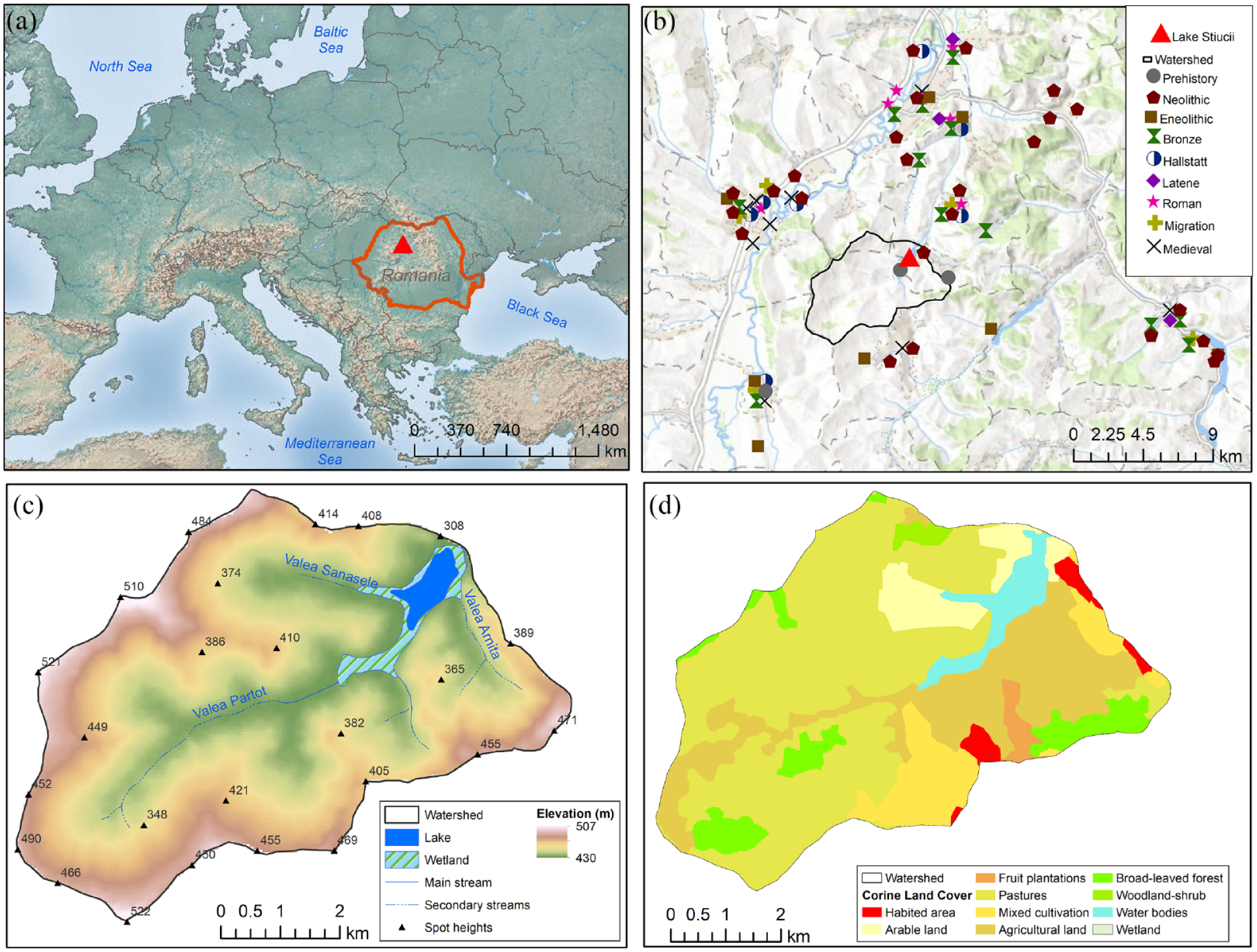
(a) Location of the study area in Europe. (b) Archaeological sites in the Lake Stiucii area. (c) Digital elevation model. (d) Corine Land Cover (2018) maps of the Lake Stiucii catchment.
The climate of the region is temperate continental with a mean annual temperature of 8–9°C and mean annual precipitation of 500–600 mm. The geology of the area comprises Neogene marls and sands intercalated with volcanic tuffs and salt deposits. Haplic and luvic chernozems are the main soil types of the catchment (IUSS Working Group WRB, 2007). The catchment is now affected by moderate to accelerated erosion, especially sheet erosion, which affects the upper catchment (Radoane et al., 2014). Currently the vegetation cover of the catchment comprises mainly mixed deciduous woodland (Quercus robus, Q. petraea, Fagus sylvatica, Carpinus betulus) on the hilltops, pastures and hay meadows, with arable crops in the lower lying areas (Feurdean et al., 2015, 2017).
Materials and methods
Fieldwork and chronology
Lake Stiucii was sampled in 2011 and 2012 using a Livingstone piston corer when a 726 cm sequence (100 cm segments) was extracted from the deepest part of the lake. A gravity corer was used for the surface sediments (37 cm) at the same location. The composite sediment profile and the age-depth model, including OSL dates, fifteen 14C measurements and 210Pb and 137Cs analysis were presented in Feurdean et al. (2013, 2015). The age-depth model shows that the basal meter of this record spans 55–35 cal ka BP, followed by a hiatus, then by continuous sedimentation over the last 11,800 years (621 cm; please see SI Section 1). Here, we focus on the continuous part of the profile of 621 cm covering the last 11.8 ka years. For this study, the age-depth model was updated using a Bayesian model in the Bacon package in R and the latest calibration curve, Intcal20 (Blaauw and Christen, 2011) (Figure S1). In the new age-depth model, we excluded only the radiocarbon age of 611 ± 23 at 33 cm in the gravity core prior to running the age-depth model as this appears far too old compared to the core’s 210Pb measurements. We retained the radiocarbon dates of 1574 ± 22 and 1076 ± 35, not included in the previous age depth model (Feurdean et al., 2013), however, the new Bayesian model rejected the 1574 ± 22 radiocarbon date.
The mean sediment accumulation rate (SAR) is 0.09 cm/yr−1 and the sample resolution 70 years.
Geochemical properties
The sedimentary geochemical properties were investigated using a Niton XL3t 900 X-Ray Fluorescence analyser (fpXRF) mounted in a shield. The accuracy of the technique was verified by comparing the results with certified reference material (CRM NCS DC73308). Only those elements where the relative percent difference between the concentration reported for the reference material and the concentration measured by the fpXRF was <10% are given. The output from the Niton XL3t 900 FPXRF includes a two-sigma (two standard deviations from the mean) margin of error for each reading (Niton XL3t 900 Product Specification).
Mineral magnetic measurements
Magnetic susceptibility of the entire core was measured with a Bartington Instruments Ltd. MS2 meter and a C sensor. In addition, the sediments were analysed with a Bartington Instruments Ltd. MS2 meter and MS2B sensor at both low and high frequency allowing the calculation of low frequency (χ) and frequency dependent magnetic susceptibility (χFD) (Dearing, 1999). A Molspin Ltd. Pulse Magnetiser was used to determine the saturated isothermal remanent magnetisation (SIRM) in a magnetic field of 1.0 T. The resulting magnetic remanence was determined with a Minispin Fluxgate Magnetometer (Akinyemi et al., 2013; Hutchinson, 1995; Walden et al. 1999).
Organic and carbonate content
Organic matter (OM) and carbonate content (CaCO3) were determined using the loss-on-ignition technique (Santisteban et al., 2004). The dried samples (40°C) were homogenised and sequentially heated for 4 h to 550°C (LOI550) and to 950°C (LOI950) respectively to estimate the content of organic matter and carbonates.
Particle size distribution
The particle size distribution was determined using a Horiba Laser Particle Size Analyser (Partica LA-950). This instrument complies with ISO 13320 (Particle size analysis – Laser diffraction methods) with a documented accuracy of 3% on the median of broad-distribution standards with a precision of 0.1%. Repeated measurements (3 times) of each sediment sample were performed (after 1 min of ultrasonication) in order to minimise uncertainties. Here we use the particle size distribution (D10, D50, D90) to characterise the erosional activity in the catchment (Håkanson and Jansson, 1983).
Statistical analyses
Principal component analysis (PCA) was performed on selected geochemical, mineral magnetic and organic matter parameters to investigate the associations between proxies in each lithological interval and to identify which of those proxies explain most of the sediment variability. PCA was run on a correlation matrix in RStudio using ‘Factoextra’ version package (R Development Core Team, 2010). The significant axes were identified via the broken stick model.
Temperature and precipitation dataset
Temperature and precipitation datasets were extracted from TRaCE21ka, a climate experiment based on the Community Climate System Model version 3 (CCSM3) (Collins et al., 2005; Liu et al., 2014; Otto-Bliesner et al., 2014). The data was extracted using the PaleoView software (Fordham et al., 2017). The climate data has a spatial resolution of 2.5 × 2.5° (latitude/longitude) and was downloaded for the grid which covers our study area. The modelled temperature and precipitation anomaly dataset was downloaded at 10-year intervals for the period spanning 11.8 cal ka BP to present. The temperature and precipitation values are expressed as anomalies from present-day (1985 AD).
Archaeological information
As the area around Lake Stiucii holds long-term traces of human habitation and is abundant in archaeological remains, we extracted archaeological information from the national database (National Archaeological Repository, http://ran.cimec.ro/) limited to a 10 km radius, considered to be a relevant area relative to the extent of the lake catchment. A total of 56 archaeological sites were identified including mainly settlements and a few cultural/religious structures. The results are presented as sum of archaeological sites per archaeological epoch.
Results and interpretation
Lithological composition and multi-proxy description
The composite profile (621 cm), spanning the full Holocene was divided into three lithological units (I–III) based on the characteristics of the sediments. These major changes in lithostratigraphy are also reflected in the geochemical and mineral magnetic properties indicating that conditions in the lake and its catchment have changed over time.
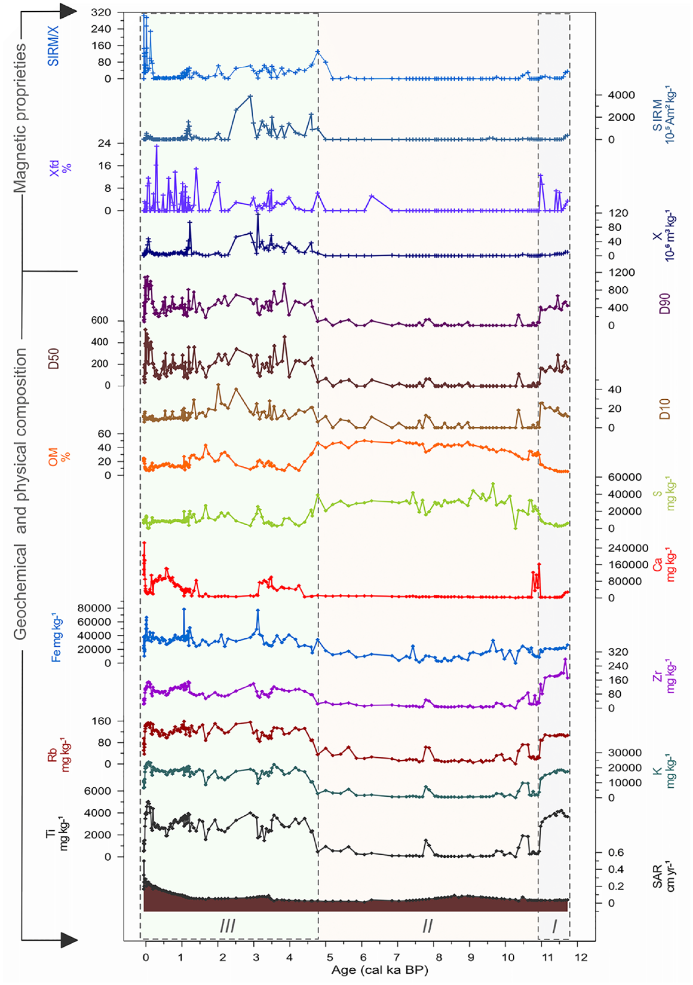
Lithological unit I covers the interval 621 to 590 cm (11.8–10.9 cal ka BP) and is composed of clay (621–605 cm, 11.8–11.4 cal ka BP) and clayey gyttja (605–590 cm, 11.4–0.9 cal ka BP) with SAR values of 0.04 cm/yr-1 and high values of detrital elements (Ti, K, Rb, Zr) and a coarse grain size (D90) and low values for Ca and organic matter (<20%) (Figure 2). Magnetic susceptibility (χ) and SIRM show low values whereas χFD shows some higher values above 5%.
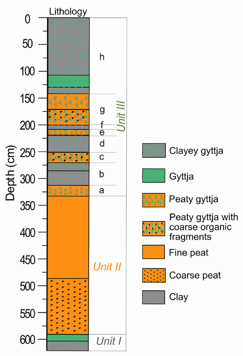
Lithological profile of the Lake Stiucii record.
Lithological unit II (590–330 cm, 10.9–4.6 cal ka BP) is characterised by coarse Phragmites (590–485 cm, 10.9 and 8.9 cal ka BP) and fine peat (485–330 cm, 8.9 and 4.6 cal ka BP) with a slight increase in SAR values between 10 cal ka BP and 8 cal ka BP, followed by a decline (Figure 2). The detrital elements (Ti, K, Rb, Zr), grain size (D10, D50, D90) and magnetic parameters, that is, χ, χFD, SIRM, SIRM/χ show the lowest values of the entire record. However, two peaks are visible around 10.6 and 7.8 cal ka BP. Ca show a peak between 10.9 and 10.7 cal ka BP. Conversely, S and organic matter (OM%, >40%) register the highest values of the entire record.
Lithological unit III spans the interval between 4.6 and −0.062 cal ka BP (330 cm and 0 cm depth) and was divided into eight subunits characterised by alternating layers of various composition ranging from clay gyttja to peaty-clayey and peat (Figures 2 and 3). SAR registers the highest values of 0.1 cm/yr-1. The detrital elements (Ti, K, Rb, Zr) and also the grain-size (D10, D50, D90) and magnetic parameters, that is, χ, χFD, SIRM, SIRM/χ register a shift towards higher values and peak around 4.4–4.1, 3.5, 3.0–2.5, 1.9, 1.5, 1.1–0.8, 0.6 cal ka BP. Ca shows oscillating trend while sulphur and organic matter (OM%, <40%) show a decreasing pattern.
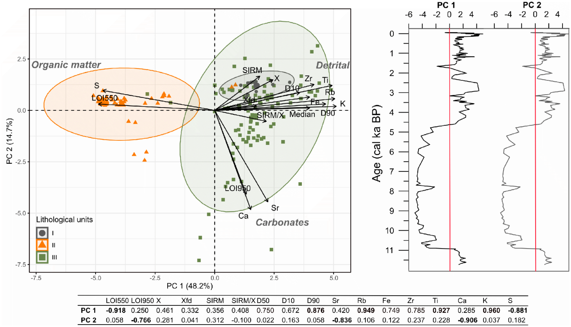
Results of the principal component analysis (PCA) applied to selected abiotic proxies (right panel) with points and confidence ellipses coloured according to the lithological units (left panel). The bottom table presents the correlations between dataset and PC1 and PC2 (high correlation coefficient are marked in bold). PC1 and PC2 sample scores showing major shifts in erosion intensity and respectively carbonates.
Characterisation of lithological units
The associations between the lithological units are statistically evaluated to assess their potential for reconstructing past environmental conditions and changes in the lake-catchment system over the post glacial period. The first two components of the principal component analysis, PC1 and PC2, explain 64% of the data variance and allow the identification of three main geochemical pools. The first pool is related to the first component (PC1, 49%) depicting a detrital component and is mainly represented by Ti, Rb, K and (coarse) grain size (D90). This component is inversely correlated with a second pool with high negative loadings for organic matter (LOI 550) and S indicating an organic component. The distribution of the geochemical parameters across the lithological units reveals the association of Unit I with PC1 in a positive direction, a strong correlation for Unit II with PC1 in a negative direction representing an organic pool, while Unit III, given its high variability, is spread across the first two pools. The third pool is related to the second component (PC2, 15%) and shows a high negative loading for LOI950, Ca and Sr indicating a carbonate component. The PCA sample scores were used to discriminate the major changes in erosion intensity (PC1+) and carbonate deposition (PC2−).
Lithological and geochemical associations
Statistical evaluation using PCA correlation shows that geochemical associations change with depth. Ti, K, Rb, Zr and Fe follow a similar trend and form a pool especially for Units I and III. These elements can be indicative of siliciclastic allochthonous input reflecting erosional activity in the catchment (Hubay et al., 2018; Kylander et al., 2011). Ti, Rb and K are mainly linked with the fine, clay sediment fraction whereas Zr is predominantly associated with coarse silt and sands (Kylander et al., 2011). Here Zr, also supported by grain-size (D90), dominates Unit I and indicates the transport of coarser particles from the catchment. Fe reflects a range of circumstances; it can have a detrital origin indicating changes in the source of sediments, but it can also mirror changes in lake oxygenation conditions (Naeher et al., 2013). In this core, Fe shows a slightly divergent trend with depth. Given the pattern of Fe and the lithological linkages indicated by the PCA, it seems that, in unit III, Fe has a predominantly minerogenic origin. However, in unit I and II, Fe shows only small variations which could be associated with changes in sediment sources and/or different oxygenation conditions.
Sulphur in sediments is mainly linked to organic matter residing in the biomass of aquatic plants or terrestrial material as organic sulphur and as mineralised sulphur in their remains (Drevnick et al., 2010; Urban, 1994). In the sediment column, sulphur can be oxidised and can re-enter the water or it can be buried within sediments by bacterial activity. Given the marked association between sulphur and organic matter content, and the lack of association with the detrital elements, it seems that organic sulphur, either terrestrial or lacustrine in origin, is a component of our sediments (Figures 2 and 3).
The presence of Ca in sediment cores is usually related to carbonate weathering in the catchment and in-lake precipitation (biogenic or chemical precipitation) in the form of CaCO3. As this element can have both allochthonous and autochthonous sources its origin is not easily distinguishable. We interpret changes in Ca alongside the LOI-derived carbonate (LOI950) and organic matter estimates (LOI550). However, warmer conditions and/or lake levels changes may facilitate biogenic carbonate production given its solubility (Lézine et al., 2010).
Sediment magnetic properties are important proxies in paleoenvironmental and paleoclimatic studies as they can reflect hydrologically-driven processes such as catchment soil erosion and lake sediment inputs in response to climatic, environmental and anthropogenic changes (Dearing et al., 2001; Mullins, 1977; Shouyun et al 2022). Magnetic susceptibility (χ) and saturation isothermal remanent magnetisation (SIRM) usually reflect changes in the concentration of magnetic minerals such as ferrimagnetic minerals and so reflect the input of magnetic (pedogenic) minerals eroded from the catchment slopes and the stream channels (Wang et al., 2021). χFD% and SIRM/χ are grain-size sensitive parameters and their presence can indicate the contribution of superparamagnetic (SP) magnetic minerals which usually result from pedogenic processes and which, in turn can indicate increased surface erosion as a sediment source (Liu et al., 2012; Mullins, 1977; Wang et al., 2021). However, after deposition, under high lake anoxia, authigenesis/diagenesis and biogenesis processes can modify magnetic minerals affecting the original magnetic signal (Liu et al., 2012; Nowaczyk, 2001; Roberts, 2015; Roberts et al., 2018). Nevertheless, in the sediment profile the changes observed in magnetic parameters follow the changes in depositional phases suggesting that authigenic and/or diagenetic processes are most likely insignificant in our record. In a hydrologically closed basin, as is the case of Lake Stiucii, with seasonal precipitation changes it is also expected that changes in magnetic parameters, and also other proxies, will be related to changes in the catchment, for example, precipitation and erosion, soil development, vegetation change and which are subsequently influenced by changes in climate.
Sediment accumulation rate (SAR) can be controlled by changes in lake productivity, but it is also an indicator of catchment erosion rates where allochthonous material enters the lake (Bonk et al., 2016; Oldfield and Dearing, 2003). As a large proportion of Lake Stiucii sedimentation is of terrigenous origin, SAR can be used here as an indicator of changes in sediment input. The grain-size parameters (D10, D50 and D90) are related to changes in the sediment production and transport energy resulting in the accumulation of fine to coarse particles and hence can be used as an erosion intensity indicator and/or transport mechanisms (Håkanson and Jansson, 1983). We used D10 to describe changes in the clay fraction whereas D50 (median grain-size) and D90 (coarse grain-size) were used to characterise changes in coarse silt and very fine sand and respectively, very coarse sand sediment fraction.
However, the lake sits in a topographically subdued catchment. Hence, some eroded materials may not be directly or immediately transported into the lake. Instead, they may be stored in the catchment, in particular within the littoral belt around the lake. Thus, the sediment core may not provide a continuous and complete record of slope erosion, for example, if some intervals comprise a mixture of both stored and contemporaneous sediments of unknown proportions from catchment surface and stream channel sources.
Discussion
Lacustrine phase I during the closing of the Younger Dryas and the eve of the Holocene (11.8–10.9 ka) – enhanced erosion with a sparse vegetation cover and unstable catchment conditions
The deposition of clay and clay gyttja sediments in Lake Stiucii between 11.8 and 10.9 cal ka BP, with high values of terrigenous elements (Ti, K, Rb, Zr) and a coarser median particle size, indicates a predominantly allochthonous, siliciclastic input in a high energy depositional environment (Figure 5). This interpretation is supported by the grain-size dependant mineral magnetic parameters χFD and SIRM/ χ which indicate the presence of finer magnetic minerals (SP). Several studies (Liu et al., 2012; Mullins, 1977; Wang et al., 2021; Wei et al., 2018) report that these magnetic minerals are mainly characteristic of surface soil erosion and might indicate the input of magnetic minerals eroded from the catchment’s slopes. However, the very low values concentration of SIRM and χ must also be considered. Thus, this interval, dominated by coarse particle deposition, portrays a short lacustrine phase (Lake phase I) occurring between 11.8 and 10.9 cal ka BP and characterised by an open water environment with a well-connected stream system capable of carrying and depositing allochthonous particles into the lake basin (Figure 5). The low levels of Ca and S suggest a low concentration of carbonates possibly because of higher lake levels and/or lower temperatures (Lézine et al., 2010). Although we have not established the origin of the organic matter inferred from LOI550 (OM, here), studies from lakes in Europe link elevated values in LOI550 with lake productivity (Bajard et al., 2016; Schwörer et al., 2014). This often parallels a change in sediments’ terrigenous fraction that is, sand, silt. Thus, in Lake Stiucii, the low levels of organic matter indicate low lake productivity and higher terrigenous inputs, most likely under unstable soil conditions and reduced vegetation cover (Figure 5). The pollen-based vegetation reconstruction at Lake Stiucii supports this inference by showing the prevalence forest-steppe vegetation at the end of the Younger Dryas and the onset of the Holocene (Feurdean et al., 2015), which may have created a favourable erosional context for mobilising coarser particles.
The presence of a lake phase during the early Holocene at Lake Stiucii aligns with findings from numerous peatlands in Romania, which indicate that they were active water bodies during the Late glacial and early Holocene which became infilled around 10–11 cal yr BP (see section ‘Wetland phase during the Early to Mid-Holocene (10.9–4.6 ka) – diminished erosion and stabilised catchment conditions’). The proxy-based and model reconstructions further show that following cold and dry conditions, and therefore low evapotranspiration during the Younger Dryas, the region experienced a rapid increase in summer temperatures and reduced precipitation at the onset of the Holocene, around 11.7 cal ka BP (Feurdean et al., 2008a; Tǎmas et al., 2005; Tóth et al., 2015), although the climate model indicates that summer temperature remained low until 10 ka (Figure 5). The preservation of a lake phase during the early Holocene could be attributed the increase in summer temperatures and evapotranspiration, and the progressive drying up and infilling of the lake.
Wetland phase during the Early to Mid-Holocene (10.9–4.6 ka) – diminished erosion and stabilised catchment conditions
From about 10.9 cal ka BP, the sudden change in lithology from gyttja to organic sediments (peat) indicates an abrupt change in Lake Stiucii’s depositional system towards a wetland phase with shallower water. This wetland environment with well-developed Phragmites beds, acted as a barrier to the inflow of coarser sediment particles. Therefore, the sediment delivery was reduced and the routes of sediment input into the lake may have alternated between fluvial and wind-borne. Changes in geochemical signature towards finer sediments and the inference of decreased levels of erosion are supported by a substantial reduction in the detrital elements (Ti, K, Zr, Rb) and grain-size (Figures 4 and 5). The low values in all the mineral magnetic parameters in this organic-rich phase can be interpreted as a decrease in the input of magnetic minerals from the catchment and/or the result of post-depositional dissolution. It has been reported that dissolution processes are modulated by organic matter content, especially in anoxic environments (Liu et al., 2012; Roberts, 2015; Roberts and Tuner, 1993; Wang et al., 2021). However, there is no correlation between organic matter and magnetic parameters in our record (Figure 3) and a down-core decrease in the magnetic concentration dependent parameters (χ, SIRM) is not visible. Changes in the magnetic parameters follow a similar trend to those of the terrigenous elements which further indicate that authigenic and/or diagenetic processes are most likely insignificant in our record. The parallel sustained trends of organic matter and sulphur suggest anoxic conditions and peat growth supported by the predominantly warmer climate conditions during early and mid-Holocene (Figure 5). The pollen record shows the expansion of forest cover (Figure 5) composed predominately of deciduous trees (Quercus, Ulmus, Corylus), and Picea abies that may have contributed to the stabilisation of the catchment’s soils (Feurdean et al., 2015). We note that disturbances by fire and herbivores were common during this time and there is also a slight increase in the number of archaeological sites from 7 cal ka BP (Feurdean et al., 2015). However, our geochemical and mineral magnetic record evidence little impact of these Early to Mid-Holocene disturbances on the Lake Stiucii catchment (Figure 5) likely because the site became a wetland with a less effective sediment delivery into the lake.
The main geochemical, physical and mineral magnetic proprieties of the Lake Stiucii record covering the last 12,000 years. The major lithological units are delineated by vertical dashed lines.
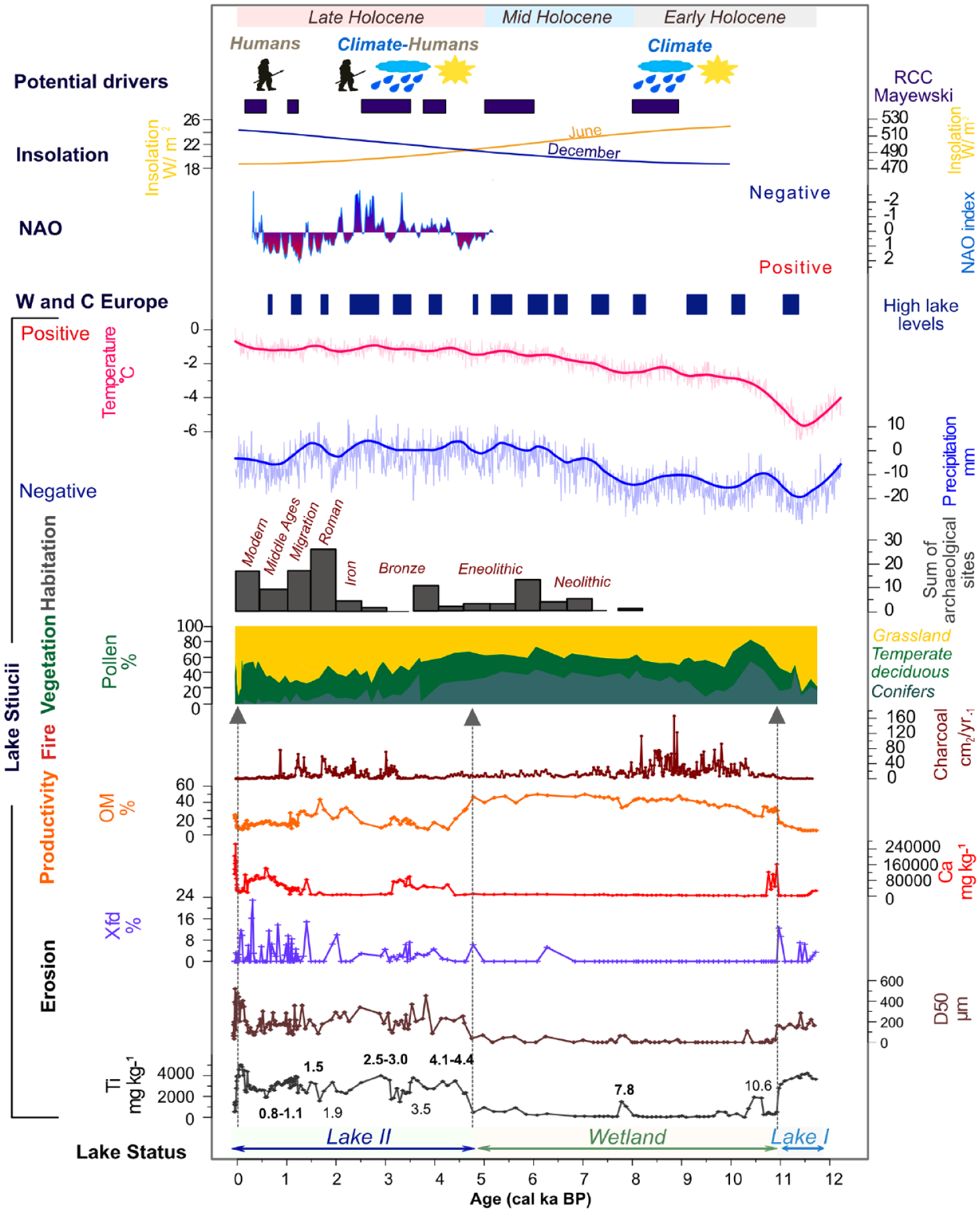
Integration of Lake Stiucii’s palaeoenvironmental and palaeoclimatic reconstruction including Ti, D50 based erosional activity; OM based productivity; macro-charcoal based-fire activity; pollen-based vegetation changes as well archaeological based habitation prevalence. The coloured intervals and the dashed lines delineate the main lithological units and interpreted lake status. This local-regional picture of environmental change is compared with regionally modelled-temperature and precipitation, and with other lake sediment records: for example, high-lake levels in W and C Europe (Magny, 2004), regional climatic changes (Mayewski et al., 2004) and atmospheric indices, for example, NAO index (Olsen et al., 2012) and insolation (Berger and Loutre, 1991). The upper sketch illustrates the potential drivers of environmental change as inferred from our reconstruction. The main chronostratigraphic limits are also indicated.
This major transition in the depositional system from a lake to wetland at a 10.9 cal ka BP, persisting until 4.6 cal ka BP, appears to be connected to local and regionally higher than today’s summer and annual temperatures, and evapotranspiration along with lower precipitation (Renssen et al., 2009; Feurdean et al., 2020) (Figure 5). Notably, this drying phase of the basin at Lake Stiucii corresponds to a widespread pattern of similar hydrological trends register in key records from the Carpathians and is manifested by the lowering of lake levels, the infilling of basins visible as a transition from lacustrine to peatland environments, or by prevalence of dry peat surface conditions (Diaconu et al., 2017; Feurdean and Bennike, 2004; Feurdean et al., 2007; Magyari et al., 2009; Tóth et al., 2018). Regionally changes in river patterns indicate a major reorganisation of runoff following the establishment of more stable climate conditions at the beginning of the Holocene (Persoiu et al., 2022). Archives around 45° N document low lake levels (Magny et al., 2013) and reduced erosion (Rapuc et al., 2019; Vannière et al., 2013; Wirth et al., 2013). Overall, there is a possibility that intensified evaporation due to rising summer temperature may have driven this widespread scale pattern of lower water levels and consequently initiation of wetland formation through basin infilling.
Lacustrine phase II during the Late-Holocene (4.6 ka – present) – dynamic catchment conditions and variable erosion with a rise in human activities
At 4.6 cal ka BP, the shift in sediment type from fine peat to peaty gyttja denotes the initiation of a second lacustrine phase (Lake II see Figure 5). However, changes in the abiotic parameters had already started at 6 cal ka BP (Figure 5). This is visible in the increases in Ti, K, grain-size (D50), but less so the mineral magnetic parameters and inter-paramagnetic ratios, indicating low levels of surface erosion which implies that catchment processes became more dynamic and fluvial transport and likely channel erosion was reactivated (Figures 4 and 5). This also implies that sedimentation became controlled by allochthonous processes. The pollen record at Lake Stiucii shows an increasing anthropogenic pressure from ca. 4.7 cal ka BP recorded by the steady decline in tree cover and a parallel increase in grassland and cultivated areas (Feurdean et al., 2015). This pattern is also echoed by the rising number of archaeological sites of Bronze Age in the area (Figure 5).
Changes in the lacustrine system towards higher sensitivity to detrital events (Haliuc et al., 2017) and river channel modification in Transylvania (Perșoiu, 2010) suggest a major reorganisation of run-off activity at this time. The river systems and sediment delivery into lakes along the Danube Plain also depicted an intensification in fluvial activity (Perșoiu et al., 2017). Lake levels in central Europe increased after 4.5 cal yr BP (Magny et al., 2013). Furthermore, a mid-Holocene climate shift to colder temperatures, higher precipitation particularly in winter and a deeper water table on peatlands has been demonstrated in Romania around 4.8 to 4.6 ka (Diaconu et al., 2017; Feurdean et al., 2008b; Magyari et al., 2009; Onac et al., 2015; Perșoiu et al., 2017). Overall, the timing of the change in the lacustrine system coincides with a major shift in atmospheric circulation patterns towards a positive North Atlantic Oscillation (NAO+) and a stronger influence on Mediterranean climate during winter (Perșoiu et al., 2017). In addition, human activities impacted the soil stability by increasing the sensitivity of their catchments to climate-driven erosion as indicated by studies in the lakes in the Danube Plain (Feurdean et al., 2021) and the Alps, Lake Anterne (Giguet-Covex et al., 2011, 2012), and Lake Ledro (Joannin et al., 2014; Vannière et al., 2013). Therefore, it can be proposed that this significant switch in the depositional system of Lake Stiucii was an initial response to increased regional precipitation, subsequently accelerated by agropastoral activities. Increased rainfall could also enhance erosion and the deposition of finer particles, sealing the lake’s bed and making it more efficient in holding water, thereby reducing percolation, and ultimately promoting water accumulation.
Short-term erosional events during the Holocene
Superimposed on the general trends in the environmental conditions, several isolated peaks in terrigenous elements (Ti, K, Rb) and grain-size indicative of short-lived erosional events were recorded during the Holocene The oldest erosional events around 10.6 cal ka BP and 7.8 cal ka BP, occur during the wetland phase, and may be related to stormy and windy conditions able to breach the littoral barrier of the wetland and transport material to the lake. Interestingly, the 10.6 cal ka BP erosional event overlaps an increase in local fire activity (Figure 5), and it is possible that these local fires led to a greater availability of material for (wind) transport. A change in the pattern of Transylvania’s rivers was observed around 10.2 cal ka BP (Persoiu, 2010) associated with the 10.2 climatic event (Björck et al., 2001, Magny et al., 2007). However, given the time lag, it is unlikely that the same climatic event is registered at Lake Stiucii.
The second erosional event placed around 7.8 cal ka BP overlaps a slight decline in modelled precipitation, which is still relatively high when compared with the Early Holocene pattern (Figure 5). This is temporally close to the 8.2 event, which is the most frequently identified short-term climatic event in records across the Carpathians. However, the 8.2 event is recorded with seasonally different expressions, that is, increased winter and spring moisture and alternating moist/cool-dry/warm summer conditions (Drăguşin et al., 2014; Feurdean et al., 2008b; Pál et al., 2016, 2018; Panait et al., 2017; Tǎmas et al., 2005), thus showing its regional manifestation, or likely uncertainties in what proxy reconstructions register (Kwiecien et al., 2022).
The short-term erosional events became more frequent during the Late-Holocene, the most visible occurred between 4.4–4.1, 3.5, 3.0–2.5, 1.9, 1.5, and 1.1–0.8 cal ka BP (Figure 5). The erosional events at 4.4–4.1, 3.5 and 3.0 to 2.5 and around 1.9 and 1.5 cal ka BP are characterised by high values of terrigenous elements, for example, Ti, K, grain-size (D50 and D90) and magnetic properties (χFD, SIRM), overlap a slight increase in the modelled precipitation levels and temperature, which suggests increased runoff under wet and warm conditions (Figure 5). However, the pollen record also show sustained anthropogenic activities in the Lake Stiucii catchment (Feurdean et al., 2015) and suggest that, additionally, humans were markedly altering the landscape through agricultural practices and reducing the forest cover. The timing of these erosional episodes agrees with those seen in other records across the Carpathians including Lake Ighiel, the closest record to our site (ca 100 km) (Haliuc et al., 2017), and the Sureanu record (ca 150 km, Longman et al., 2017). Wetter events, expressed as increases in lake levels and peatland moisture, or changes in isotope stratigraphy are visible in the NW and SW Carpathians (Cristea et al., 2013; Diaconu et al., 2017; Feurdean et al., 2008b; Longman et al., 2017; Magyari et al., 2009; Panait et al., 2017; Schnitchen et al., 2006). Greater fluvial activity is also observed in the Lower Danube (Howard et al., 2004; Kiss, 2019). In addition, a temporally synchronous increase in dust and sand particles, and Ti was noted around 1.9 and 1.5 cal ka BP in the upland sites such as Taul Muced (Panait et al., 2019) and Sureanu peatbogs (Longman et al., 2017) in the Carpathians and were associated with local to regional deforestation, fire activity and likely wet and windy conditions.
The next sustained erosional input, placed between 1.1 and 0.8 cal ka BP, partly overlaps the Medieval Climatic Anomaly (MCA), a continental-wide period of overall warm conditions and increased societal pressure (Büntgen et al., 2011; Mann et al., 2009). During the MCA, although the modelled precipitation anomalies show a decline (Figure 5), proxy records in the Carpathians (Florescu et al., 2017; Haliuc et al., 2017; Longman et al., 2019; Panait et al., 2019; Persoiu and Persoiu, 2018) point to wetter conditions, for example, wet spells, increased peatland moisture and erosion. It is likely that warm and wet climate conditions, coupled with the intensification of agropastoral activities (Figure 4) favoured the input of clastic elements into Lake Stiucii.
The most recent erosional activity from around 0.2 cal ka BP is particularly notable with marked levels of lithogenic elements, χFD, χ, SIRM, SIRM/χ and the median particle size exhibiting unprecedentedly high levels of surface erosion. This high-magnitude erosion input is likely human-driven as it overlaps a period of woodland clearance and intensification of agropastoral activities in the area (Feurdean et al., 2017).
Conclusions
Spanning more than 12,000 years, Lake Stiucii’s record is one of the oldest lowland lacustrine records to have been investigated in Romania (CE Europe). The multi-proxy results obtained from this archive offers a deeper understanding of lake and landscape responses to climate shifts and human activities in a region that remains poorly investigated.
The sediment proxies at Lake Stiucii indicate three major depositional phases over the past twelve millennia, driven by continental to regional scale climate and vegetation change associated with shifts in insolation patterns. During the first, lacustrine phase, occurring at the transition from Younger Dryas to the Early Holocene (11.8–10.9 cal ka BP), a less developed forest cover and intense erosional activity reflect a responsive lake-catchment system. A second, more stable wetland phase developed during the Early to Mid-Holocene (10.9–4.6 cal ka BP) when forest cover increased, and sediment sources shifted from allochthonous- to autochthonous-dominated, likely under the warmer conditions of the Holocene. At 4.6 cal ka BP a marked shift towards a second lacustrine phase, with an unstable catchment-lake system took place; the erosional events likely reflect the stronger influence of moist Mediterranean air masses in winter. This instability, characterised by shorter-term erosional events, seems to reflect the combined influence of climate variability and human activities. In addition to the longer-term, millennial-scale trends visible as three major depositional phases, the record was punctuated by a series of shorter-term erosional events placed around 10.6, 7.8, 4.4–4.1, 3.5, 3.0–2.5, 1.9, 1.5, 1.1–0.8 cal ka BP. They reflect short-term regional precipitation pulses and possible large-scale hydro-climate connections. However, the most recent events were also influenced by human activities which altered the landscape through agricultural practices.
The Lake Stiucii record spans a longer period at a higher resolution than any previously sites reported in CE Europe and draws a complex local-to-regional picture of environmental changes highlighting the interplay between natural and anthropogenic drivers.
Supplemental Material
sj-docx-1-hol-10.1177_09596836241254477 – Supplemental material for Tracing climate and human-driven erosional activity in the Transylvania lowlands (Central-Eastern Europe) during the Holocene
Supplemental material, sj-docx-1-hol-10.1177_09596836241254477 for Tracing climate and human-driven erosional activity in the Transylvania lowlands (Central-Eastern Europe) during the Holocene by Simon M Hutchinson, Aritina Haliuc and Angelica Feurdean in The Holocene
Footnotes
Acknowledgements
AH acknowledges financial support from ERASMUS (2012). A Frantiuc is acknowledged for his assistance in the laboratory and, in particular, for his advice on spatial data processing. We also thank D Veres, M Braun and K Hubay for their help during fieldwork.
Author contributions
Funding
The author(s) disclosed receipt of the following financial support for the research, authorship, and/or publication of this article: This work was supported by a grant of the Ministry of Research, Innovation and Digitization, CNCS – UEFISCDI, project number PN-III-P1-1.1-TE-2021-0465, within PNCDI III and Deutsche Forschungsgemeinschaft (grant numbers FE_1096/2 and 1096/9).
Supplemental material
Supplemental material for this article is available online.
References
Supplementary Material
Please find the following supplemental material available below.
For Open Access articles published under a Creative Commons License, all supplemental material carries the same license as the article it is associated with.
For non-Open Access articles published, all supplemental material carries a non-exclusive license, and permission requests for re-use of supplemental material or any part of supplemental material shall be sent directly to the copyright owner as specified in the copyright notice associated with the article.