
Abstract
The Pergamon micro-region (western Türkiye) has experienced several phases of increased geomorphodynamics during the Holocene. However, the role of local–regional human activities during a transformation between Hellenism and the Roman Imperial period and supra-regional climate fluctuations is still under discussion. Five sediment profiles from the alluvial fan of the rural Deliktaş catchment are analyzed and radiocarbon-dated to provide a sedimentological record covering the Holocene. Our results indicate seven phases of changing sediment dynamics. Five Holocene cycles of coarse- and fine-textured fan sediment deposition covered the paleochannel deposits of the Çaylak creek, and the floodplain sediments of the receiving Geyikli river which aggraded toward the piedmont during the Mid-Holocene. The landscape became stable on the Deliktaş fan and Geyikli floodplain at least ca. 4–3.4 cal ka BP as indicated by paleosols. These paleosols were again buried by fan sediments marking the first phase of accelerated geomorphodynamics during the Late Holocene. Both the local onset of human activities and the regional Mid-Holocene aridization with rapid climate changes play a role. The increased number of archeological sites and high human pressure on the environment during the Hellenistic–Roman transformation in the Deliktaş area and Pergamon micro-region were hypothesized to contribute to a phase of increased geomorphodynamic activity during the last 2.5 ka. This, however, is less apparent in our record. Our study emphasizes the importance of both, the climatic system and rural-urban cultural history, on landscape development, suggesting potential responses of locally diverse geomorphodynamics on regional-scale transformation in the eastern Mediterranean.
Keywords
Introduction
In the micro-region of the ancient city of Pergamon (Figure 1), known as a Hellenistic and Roman Imperial supra-regional administrative and cultural center (Knitter et al., 2013; Pirson, 2020), archeological remains reveal human occupation since ca. 11 ka BP (Aksan et al., 2022). After the Attalid kingdom bequeathed Pergamon to Rome in the second century BCE, the micro-region underwent a profound transformation characterized by population growth, doubling of the urban area, a vigorous public building program, a change of settlement structure, and demilitarization (Laabs and Knitter, 2021; Ludwig, 2023; Pirson, 2017, 2020; Wulf, 1994; Zimmermann, 2011). This transformation increased the intensity of human impacts on land use both in and around the city and its villages (Günther et al., 2021; Laabs and Knitter, 2021). Beyond, sediment archives from the micro-region indicate local-scale changing geomorphodynamics during the Middle and Late Holocene (Schneider et al., 2013, 2014, 2015; Seeliger et al., 2019; Yang et al., 2023), roughly corresponding to the fluctuations in hydroclimate, vegetation, and settlement activities in the micro-region and its neighboring areas (Becker et al., 2020). The intensified geomorphodynamics, in essence, correspond to soil erosion processes, as pointed out also for many areas in the eastern Mediterranean (Dusar et al., 2011; Roberts et al., 2019a; Walsh et al., 2019). However, the diversity of landforms (Yang et al., 2021), local tectonics (Paradisopoulou et al., 2010), human activities, and regionally varying climatic changes caused intra-regional differences in landscape development (Dusar et al., 2011).
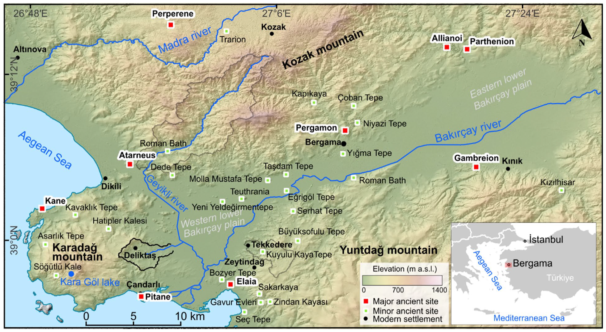
Topographical map with the locations of selected archeological sites (Ludwig, 2020b) and modern settlements in the Pergamon micro-region. The inset map indicates the location of this study in the Aegean coastal region of western Türkiye.
The eastern Mediterranean experienced a marked drying trend from around 4.6 ka BP (Finné et al., 2011) and several distinct rapid climate changes with locally varying intensity and timing (Bini et al., 2019; Weiss, 2016). The 4.2 ka BP drought event (between ca. 4.2 and 3.9 ka BP) (Bini et al., 2019; Roberts et al., 2011) and the later 3.2 ka BP drought event (two phases: 3.5–3.3 and 3.1–2.9 ka BP) (Hazell et al., 2022; Manning et al., 2020) are widely regarded as the most important rapid climate change events during the Mid- to Late Holocene (Bini et al., 2019; Di Rita et al., 2022). The influence of these events on the diverse landscapes in the eastern Mediterranean region (including the Pergamon micro-region) is not yet fully understood.
Located in the western Pergamon micro-region, the Karadağ mountain forms a peninsula, to the north, west, and south surrounded by the Aegean Sea. To the east, it verges on the floodplain of the lower Geyikli river, a major tributary of the Bakırçay river. The Deliktaş catchment drains the landside part of the Karadağ mountain (Figure 1). Widespread rills and gullies document severe soil erosion processes in the areas today covered by typical Mediterranean shrubland. Area-wide archeological surveys document that this area has been inhabited by humans at least since the Bronze Age; the number of settlement sites markedly increased during the Hellenistic–Roman Imperial period (Ludwig et al., 2022). Sequential subsurface stratigraphy correlative to the erosion processes in the transition zone of the Deliktaş fan and the Geyikli floodplain provides a suitable archive to document regional environmental variability of different spatial scales, which might be influenced by the drainage basin size and geology as well as their responses to climatic, tectonic, base-level changes (Van Dijk et al., 2012) and human influence (Coulthard et al., 2002; Dusar et al., 2011).
The overall objectives of this paper are to better understand (a) the complexity of local geomorphodynamics in the Pergamon micro-region, and (b) possible triggers of varying intensities of geomorphodynamic processes, that is, supra-regional climatic events and local to regional settlement activities. Comparing our findings with studies from the wider eastern Mediterranean allows us to decipher the effects of climate and humans as spatiotemporally varying forces on the Mediterranean landscape forming processes that are subject to debate for already more than 50 years (e.g. Dusar et al., 2011; Jouffroy-Bapicot et al., 2021; Vita-Finzi, 1969, and references therein). Beyond, this study will provide insights into how local landscapes respond to the (urban) transformation in the Mediterranean region.
Study site
Natural setting
The Deliktaş catchment (ca. 15 km2) is located in the eastern Karadağ mountain (Figure 1) at the western tip of the graben-controlled Bakırçay plain (Karacik et al., 2007; Yang et al., 2021). The modern climate is typical Mediterranean subhumid, characterized by prominent seasonality with dry and hot summers and mild and wet winters (Bakker et al., 2013; Peel et al., 2007). The close-by station in Dikili (Figure 1) recorded an annual precipitation of 711 mm and an annual temperature of 16.2°C (1981–2010) (Yang et al., 2021).
The Pergamon micro-region is located in one of the most rapidly extending regions on Earth (Özpolat et al., 2022), thus, being tectonically highly active, with at least nine earthquakes documented during the last two millennia (Emre et al., 2005; McHugh et al., 2006; Nalbant et al., 1998; Paradisopoulou et al., 2010; Schneider et al., 2014). A seismic landslide caused the abandonment of a rural settlement during the 20th century (Ludwig, 2020a). Pleistocene tectonics formed NW-trending normal faults within the Deliktaş catchment (Karacik et al., 2007). At present, the NE-trending Bakırçay (Bergama) graben is subsiding at a rate <1 mm yr−1 (Seeliger et al., 2017). Situated in the Dikili-Çandarlı volcanic suite of the western Anatolian Miocene volcanism, the Deliktaş catchment is dominated by upper Miocene–Pliocene rhyolite domes of the Çandarlı group (Karacik et al., 2007) where lime-free brown soils developed (Danacioğlu and Tağil, 2017).
A field survey showed very strong geomorphodynamics all over the Deliktaş catchment (Figure 2). Slopes in the upper catchment are steep (average ca. 30°, calculated from TanDEM-X data with 12.5 m resolution) and dissected by intermittent drainage ways, mainly gullies (Becker et al., 2022a) (Figure 2b and c). Bare rocks crop out predominantly on the steep slopes in the headwater area where stony soils are ubiquitous (Figure 2c). The Çaylak creek flows eastwards into the Geyikli river, a major tributary of the Bakırçay river (Figure 1). At the transition from the Karadağ mountain to the Geyikli floodplain, the Çaylak creek deposits an alluvial fan (size: 1 km2; length: 1.6 km; slope: 1°; Figure 2).
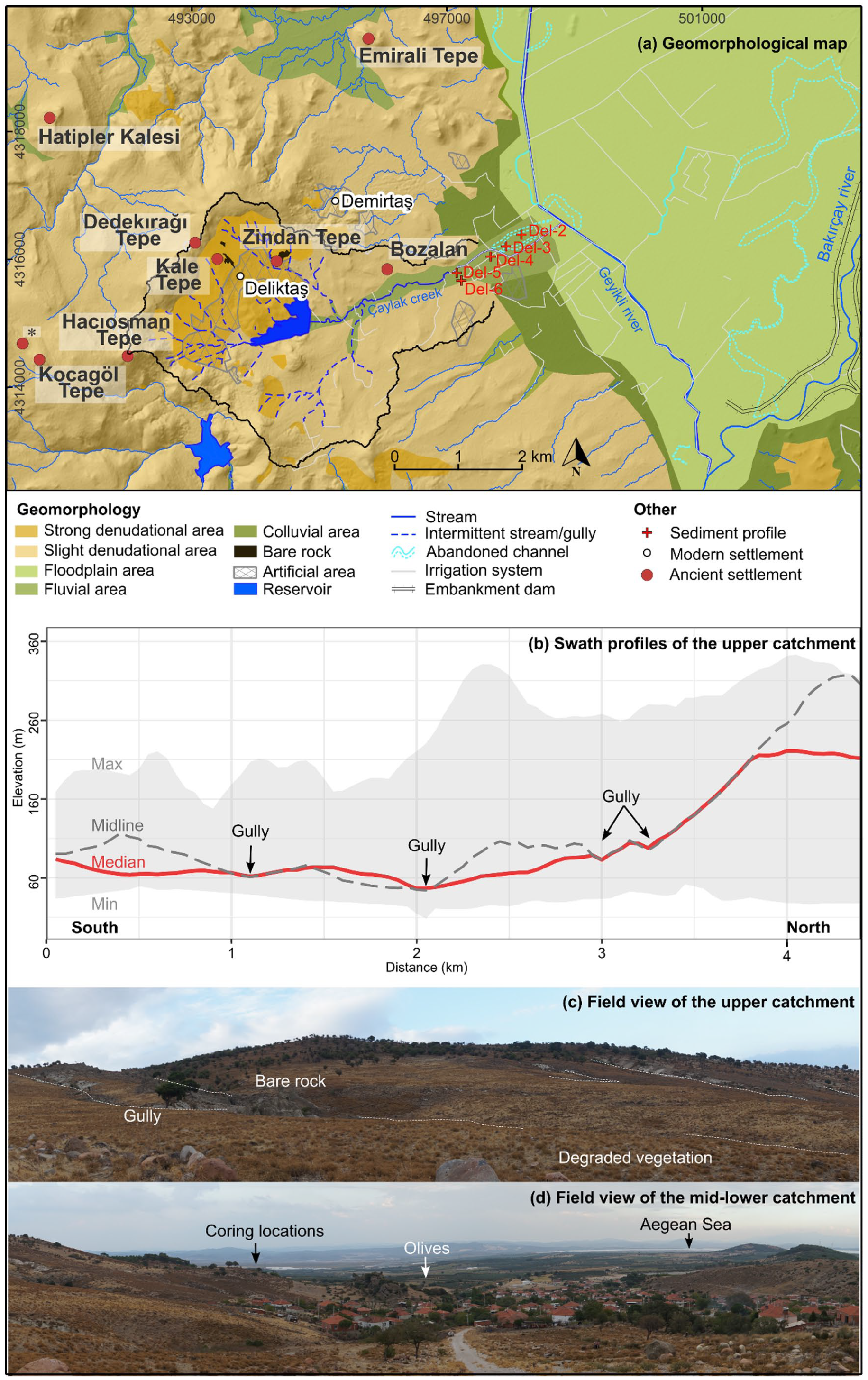
(a) Geomorphological map of the Deliktaş catchment complemented by the locations of the sediment profiles and ancient settlements (Ludwig et al., 2022). Note: *represents an unnamed archeological site. (b) Swath profiles of the upper Deliktaş catchment. (c) Field view of the upper catchment. (d) Field view of the mid–lower catchment. (Field pictures in c and d were taken on 10 Oct 2021 by the first author, which, together with figure b, were modified from Becker et al. (2022a).
Shrubs characterize the present-day vegetation cover of the Deliktaş area (Supplemental Figure S1, available online). Grasslands predominate in the northern part of the catchment; coniferous woodlands and olive groves prevail in its southern part (Figure 2c and d). From 7.6 to 3 ka BP natural deciduous oak forests prevailed around the nearby ancient harbor city of Elaia (Figure 1) (Shumilovskikh et al., 2016). A rather open landscape existed between 3.5 and 3.4 ka BP around the Kara Göl crater lake (Figure 1) (Shumilovskikh et al., 2022). Arboriculture (olive, pistachio, and walnut) extended during the Late Holocene, parallel to the spread of pastoral and tillage agriculture, likely reaching a maximum during 2.1–1.8 ka BP (Shumilovskikh et al., 2016, 2022). The spread of olives might also correspond with the contemporarily favorable climate conditions (Di Rita and Magri, 2009; Florenzano et al., 2017). In the past 1000 years, semi-natural forests (mainly pine) dominated whereas oak forests decreased (Shumilovskikh et al., 2016, 2022); olives are still cultivated. Overgrazing occurs in mountainous areas (Shumilovskikh et al., 2022).
Settlement history
The archeological survey in the Deliktaş catchment and its surroundings indicates settlement activities have started since the Bronze Age (two sites: Zindan Tepe and Hatipler Kalesi) (Figure 2; Supplemental Table S1, available online) (Ludwig et al., 2022). The number of archeological sites increased (n = 9) at the onset of the Classical period and remained high during the Hellenistic and Roman Imperial periods (ca. 500 BC–400 AD; Supplemental Table S1, available online) (Ludwig et al., 2022). Successively, only three sites were settled during the Late Antiquity, Byzantine, and Ottoman periods (Supplemental Table S1, available online).
Hilltop sites, for example, Zindan Tepe, were likely used as fortresses because they have an impressive view over the Bakırçay plain and to the cities of Pergamon, Elaia, and Pitane (Ludwig et al., 2022). Additionally, buildings in higher areas, for example, Dedekırağı Tepe and Hacıosman Tepe, are interpreted as watchtowers or tower houses as part of agricultural estates (Ludwig et al., 2022). The Deliktaş catchment is located adjacent to the major route network which connects the harbors of Pitane and Elaia with various sites in the Karadağ mountain (Fediuk et al., 2019; Laufer, 2015; Ludwig, 2020b; Figure 1).
Methods
Fieldwork
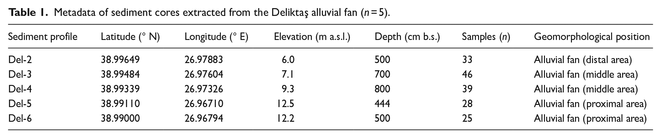
Five sediment profiles (thicknesses up to 8 m) were obtained along a transect from the proximal to distal area of the Deliktaş alluvial fan by vibracoring with open cores (5 cm diameter) in October 2021 (Figure 2; Table 1). The macroscopic sediment description included layer thickness, sediment color, depositional structure, texture and fabric, hydromorphic features, biological modification, and occurrence of artifacts (see also Yang et al., 2022). Sediment samples (n = 171) were taken according to stratigraphic layers; samples for radiocarbon dating (n = 12; Table 3) were also collected.
Metadata of sediment cores extracted from the Deliktaş alluvial fan (n = 5).
Laboratory work
Sediment analyses
Sediment samples were analyzed on six bulk parameters in the laboratory of the Bergama archeological excavation house to provide indicators for sediment origins, erosional and (post-) depositional processes (Buggle et al., 2011; Croudace and Rothwell, 2015; Ülgen et al., 2012), paleosol occurrence (Niwa et al., 2011; Nykamp et al., 2020) and human activity (Goldberg and Macphail, 2006). The aggregates of the air-dried samples were crushed. Coarse components (Ø ⩾2 mm) were separated from fine fractions (Ø < 2 mm) and weighted to calculate the mass percentage of the coarse components. Electrical conductivity (EC) and pH values of the sediments were measured at least 2 times in a suspension of 5 g dried sediments in 12.5 mL distilled water by applying a PEZ9908 meter (resolution: 0.01 pH, 1 μS cm−1 EC). The pH classification refers to the USDA soil survey manual (Soil Science Division Staff, 2017) (Supplemental Table S2, available online). Mass-specific magnetic susceptibility of the sediments was determined by triplicate measurements of weighted samples at low frequency (XLF, 10−8 m3 kg−1) in 12 cm3 plastic pots with a Bartington magnetic susceptibility system (MS3 meter and MS2B dual frequency sensor) (Dearing, 1994; Dearing et al., 1996). Loss on ignition (LOI550) as a proxy for organic matter content was measured by igniting 10 g sample materials at 550°C for 4 h in a muffle furnace after oven-drying the sediment (4 h at 105°C) (Dean, 1974; Heiri et al., 2001; Santisteban et al., 2004). Strong positive relationships between LOI550 and the total organic carbon content (Supplemental Figure S2, available online) of sediments from the western lower Bakırçay plain (Supplemental Figure S1, available online) indicate LOI550 in this region is capable to estimate organic matter content.
The elemental composition of samples from Del-2, Del-3, and Del-5 was analyzed using a portable energy-dispersive X-ray fluorescence spectrometer (p-ED-XRF; Thermo Fisher Scientific NITON XL3t-900 GOLDD+; analytical range: Mg to U) applying the “Mining Cu/Zn” mode with four filters (30 s measurement time each filter). Quality was controlled by measuring certified reference materials and acid-purified silica sand (Supplemental Table S3, available online). For elemental sediment characterization, we report the element ratios of Ca/Ti and K/Si.
Results of laboratory analyses are reported as median and median absolute deviation (MAD, in brackets) and categorized using the classifications in Supplemental Table S2, available online. Reported relationships between the variables were established based on Spearman’s correlation coefficient and related tests (α = 0.05). The assumption of (bivariate) normality is tested by applying the Shapiro-Wilk test (ggpubr v0.6.0 (Kassambara, 2023) and corrplot v0.92 (Wei and Simko, 2021)) in R (R Core Team, 2022). Raw and processed data are provided in a published dataset at PANGAEA (Yang et al., 2023).
Radiocarbon dating
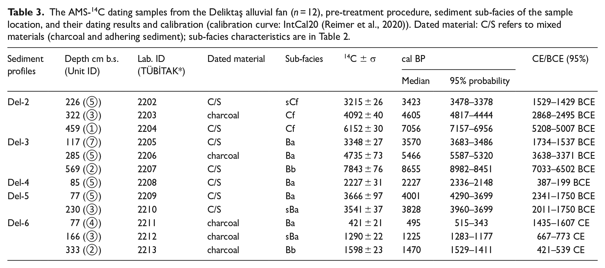
The sediment chronology is developed by radiocarbon dating (14C) of charcoal or a mixture of charcoal and adhering sediments (the latter if %C of the macroscopically separable charcoal is <1–2 mg) using accelerator mass spectrometry (AMS) at the TÜBİTAK National 1 MV AMS Laboratory (Doğan et al., 2021). Macroscopic plant remains and rootlets were removed before the samples were acid-washed (Brock et al., 2010; Fowler et al., 1986). The IntCal20 calibration curve (Reimer et al., 2020) and the rcarbon package (Crema and Bevan, 2021) were used to calibrate the radiocarbon ages in R (R Core Team, 2022). Confidence intervals of 95% are reported for the calibrated ages. The age-depth modeling of samples from profiles Del-2, Del-3, and Del-6 are calculated based on the clam R-package (v2.5.0) (Blaauw, 2010).
Sediment facies
Sediments extracted along the transect on the Deliktaş fan are categorized into seven sub-facies based on their macroscopical/lithological and (bulk-)chemical characteristics. These sub-facies are summarized into facies B, alluvial fan facies, and facies C, floodplain facies (Table 2). The classification resembles the facies described in Tekkedere alluvial fan (Yang et al., 2023), following the conventional sedimentological terminology of alluvial fan (Blair and McPherson, 1994, 2009; Moscariello, 2018) and floodplain deposits (Miall, 2006, 2014).
The characteristics of sediment sub-facies in the Deliktaş catchment (cf. Yang et al., 2023).
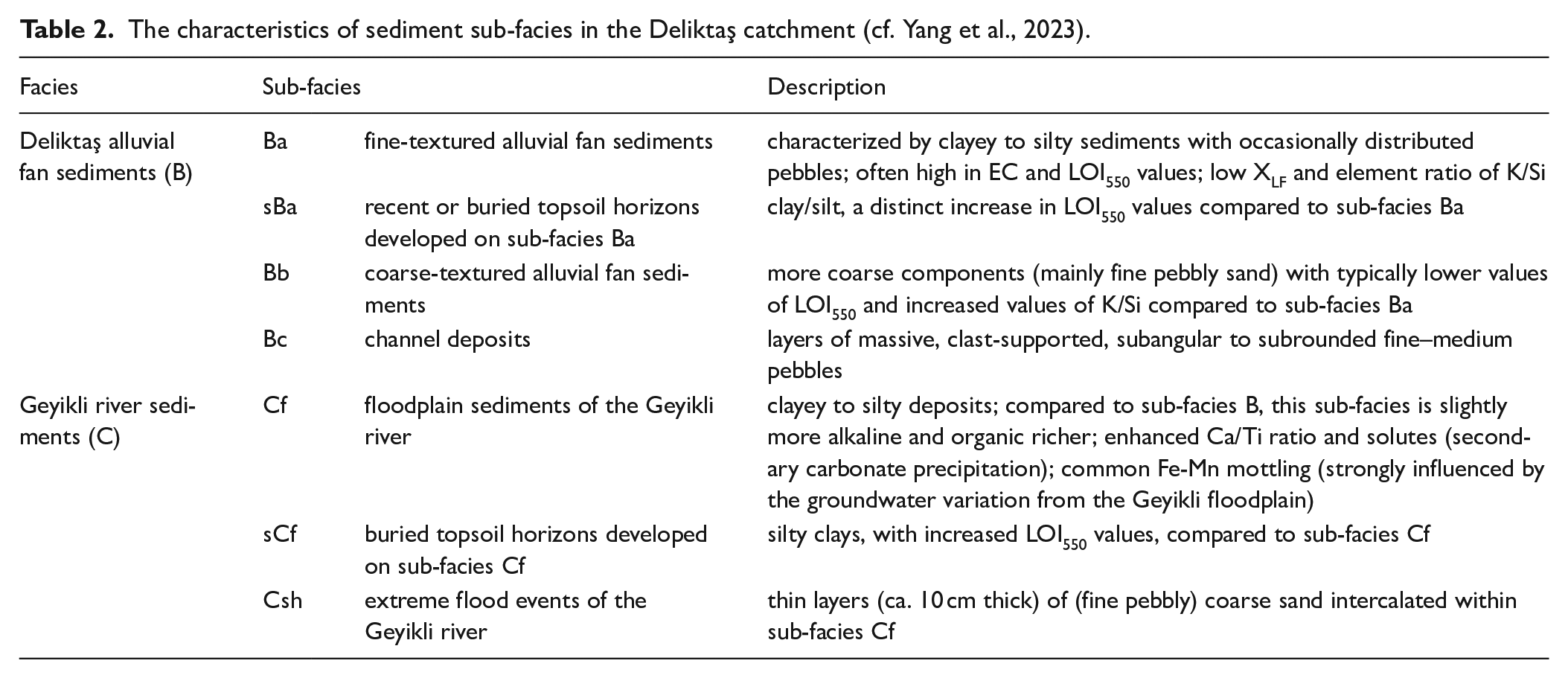
Facies B: Deliktaş alluvial fan sediments
The Deliktaş alluvial fan facies B contains four sub-facies (Table 2). Clayey to silty deposits with occasionally distributed pebbles are classified as fine-textured alluvial fan sediments (sub-facies Ba) which show generally high EC and LOI550 values, low XLF values, and low element K/Si ratios. Repeatedly sub-facies Ba is topped by a layer with distinctly increased LOI550 values indicating recent or buried top-soil horizons (sub-facies sBa). Sub-facies Bb is composed of fine-pebbly sands with typically, compared to sub-facies Ba, low LOI550 values and increased K/Si ratio, corresponding to coarse-textured alluvial fan sediments. Massive, subangular to subrounded fine–medium pebbles represent channel deposits (sub-facies Bc) (Miall, 2006).
Facies C: Geyikli river sediments
Facies C, the Geyikli river sediments, includes three sub-facies (Table 2). Dark brown clayey to silty deposits, slightly alkaline and rich in organic matter are classified as sub-facies Cf, corresponding to floodplain sediments of the Geyikli river. Thin layers (ca. 10 cm thick) of coarse sand to fine pebble (sub-facies Csh) intercalate with these floodplain sediments and correspond to stronger flood events compared to sub-facies Cf (Miall, 2006). Silty clays with high LOI550 values overlying sub-facies Cf represent buried top-soil horizons developed on the floodplain sediments (sub-facies sCf).
Sediment profiles
The sediment profiles show alternating layers of alluvial fan deposits, which are generally coarser in the profiles extracted from the proximal fan and finer downslope. At the distal part, fan deposits interfinger with floodplain deposits of the Geyikli river. Sediment core Del-3 serves as a key profile and is presented in detail (Figure 3). The other sediment profiles are presented in overview and compared with the key profile Del-3; detailed documentation is provided in the Supplemental Materials, available online. Radiocarbon datings document that fan deposition started at least in the Early Holocene and continued during the entire Holocene, and the Geyikli floodplain deposits occurred during the Middle Holocene (Figure 3; Table 3).
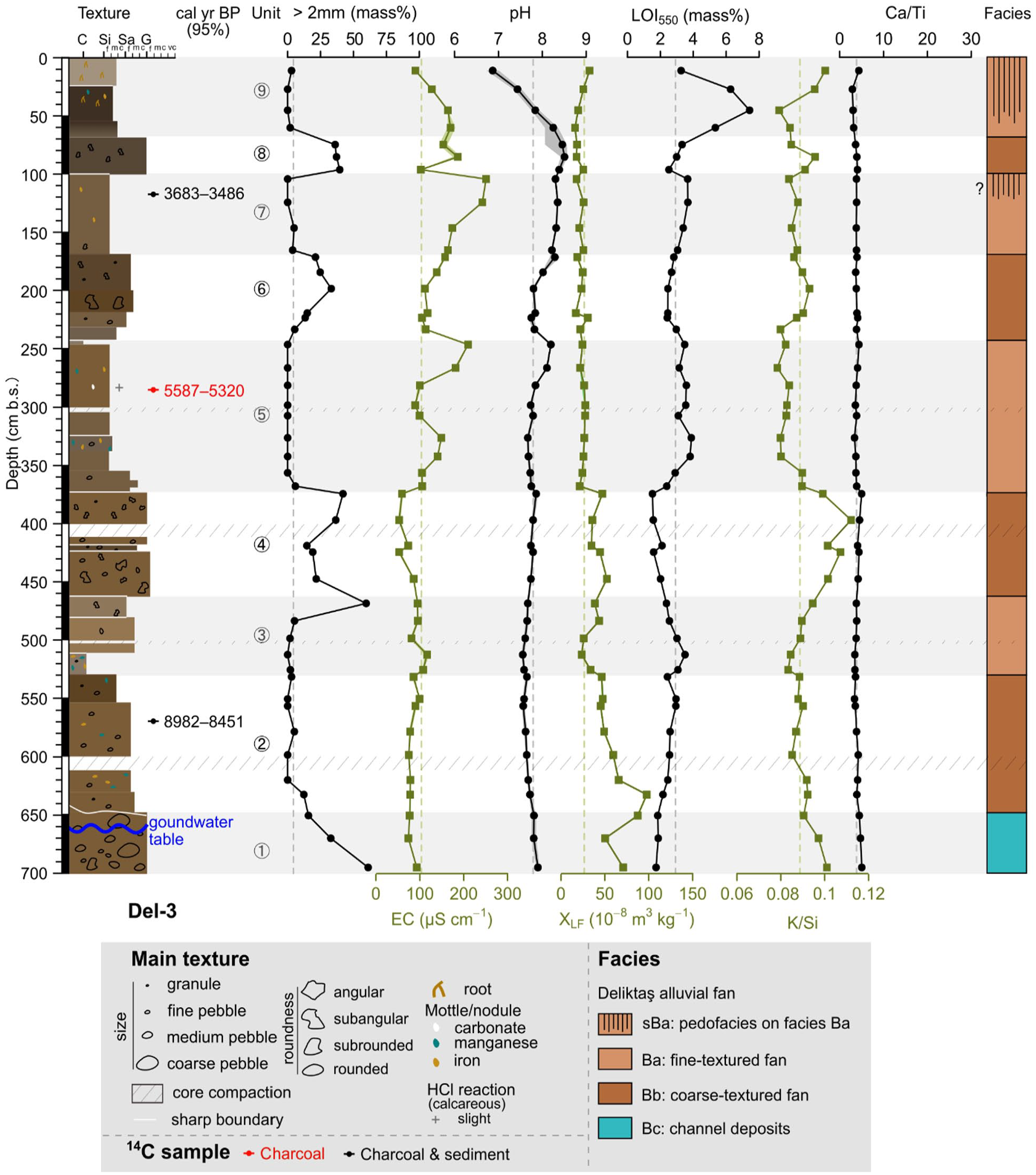
The lithostratigraphy, radiocarbon datings, sediment bulk characters, and sediment facies of profile Del-3. (1) colors of the sediment texture column represent the color observed in the field; (2) shaded bands separate different units; (3) the vertical dashed lines of each sedimentary analysis represent the median values of the whole profile.
The AMS-14C dating samples from the Deliktaş alluvial fan (n = 12), pre-treatment procedure, sediment sub-facies of the sample location, and their dating results and calibration (calibration curve: IntCal20 (Reimer et al., 2020)). Dated material: C/S refers to mixed materials (charcoal and adhering sediment); sub-facies characteristics are in Table 2.
Key profile Del-3
Key profile Del-3 was taken from the middle part of the Deliktaş fan and is 700 cm thick. It is subdivided into 9 lithostratigraphic units (Figure 3). A pebble-dominated unit at the bottom (unit 1; channel deposits, sub-facies Bc) is overlain by repetitions of sandy (units 2, 4, 6, and 8; coarse-textured alluvial fan deposits, sub-facies Bb) and silty-clayey (units 3, 5, 7, and 9; fine-textured alluvial fan deposits, sub-facies Ba) sediments. A radiocarbon sample from unit 2 dates into the Early Holocene (ca. 8.7 cal ka BP at 569 cm b.s.; Table 3). At approximately 1 m depth below the surface (unit 7, 117 cm b.s.) fan deposits are of Late Holocene age dating to ca. 3.6 cal ka BP. Accordingly, in the approximately 4.5 ka between the Early Holocene and the beginning of the Late Holocene about 4 m of sediments were accumulated. The charcoal-based radiocarbon age extracted from unit 5 (285 cm b.s.) with an age of 5.4 ka BP is in line with the aggradation rates.
In total, 46 samples were extracted from Del-3. Graphs displaying the amount of coarse fraction (particles Ø ⩾2 mm; 0–61 mass%) and K/Si ratios run highly parallel (p < 0.001, rho = 0.64), and show inverse trends to the graphs of EC (Ø ⩾2 mm and EC: p = 0.05, rho = -0.29; K/Si and EC: p < 0.001, rho = -0.58) and LOI550 values (Ø ⩾2 mm and LOI550: p < 0.001, rho = -0.71; K/Si and LOI550: p < 0.001, rho = -0.73; Figure 3). Values of pH remain roughly constant at 7.8 below 353 cm b.s. (units 1–4), slightly increase to 8.5 at 60 cm b.s., and drop rapidly to 6.9 near the surface. XLF values decrease slightly oscillating from 71 10−8 m3 kg−1 (class 3) in unit 1 to 36 10−8 m3 kg−1 (class 2) in unit 4 and remain constantly low at ca. 23 10−8 m3 kg−1 (class 1) in units 5–9. The element ratio of Ca/Ti remains relatively constant with values between 3 and 5. Altogether, sediments are poor in carbonates; only few carbonate precipitations occur around 280 cm b.s.
Other Deliktaş fan sediment profiles
Sediment profile
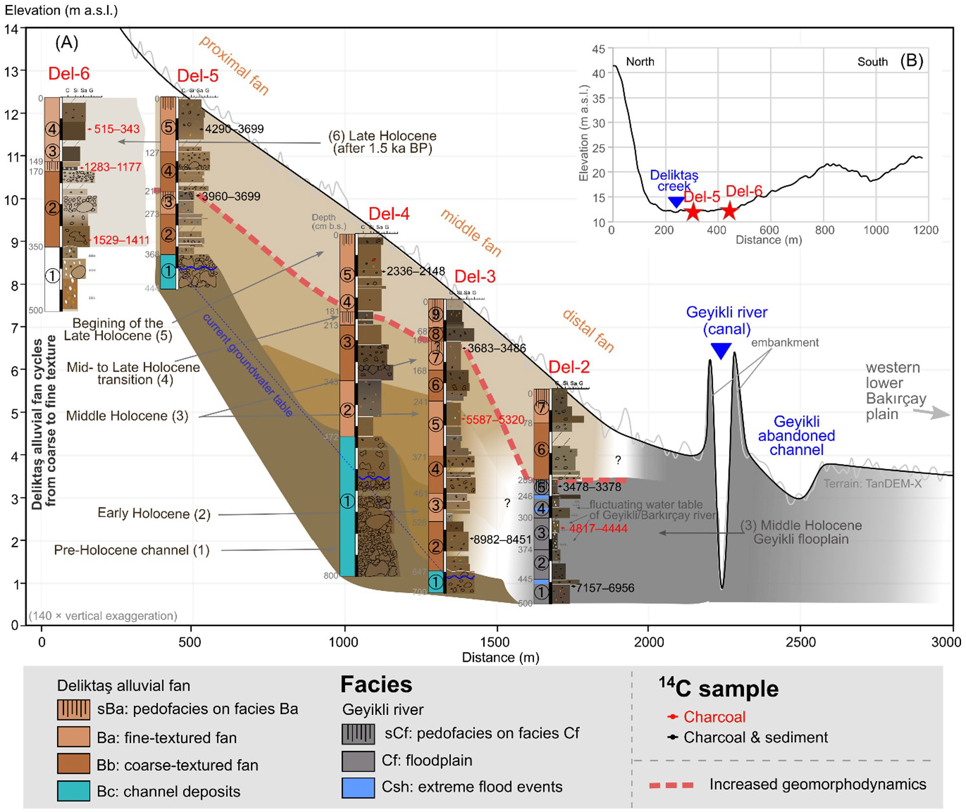
(A) The sediment profiles at a longitudinal transect on the Deliktaş alluvial fan (140 × vertical exaggerations). Note the background colors of brown and gray show the correlations of sediment facies among different profiles. (B) The location of the profiles Del-5 and Del-6 at a cross section on the Deliktaş alluvial fan (10 × vertical exaggerations).
Sediment profile
Sediment profile
Sediment profile
Holocene geomorphodynamics
The analyses of sediment profiles from the area of the Deliktaş alluvial fan indicate rapidly changing depositional processes during the Holocene (Table 4). Based on the facies classification, seven major geomorphodynamic phases can be deduced (Figure 4A).
Summary of the (pre-)Holocene sediment characteristics (a), depositional processes (b), and landscape and settlement dynamics (c) in the Deliktaş area.
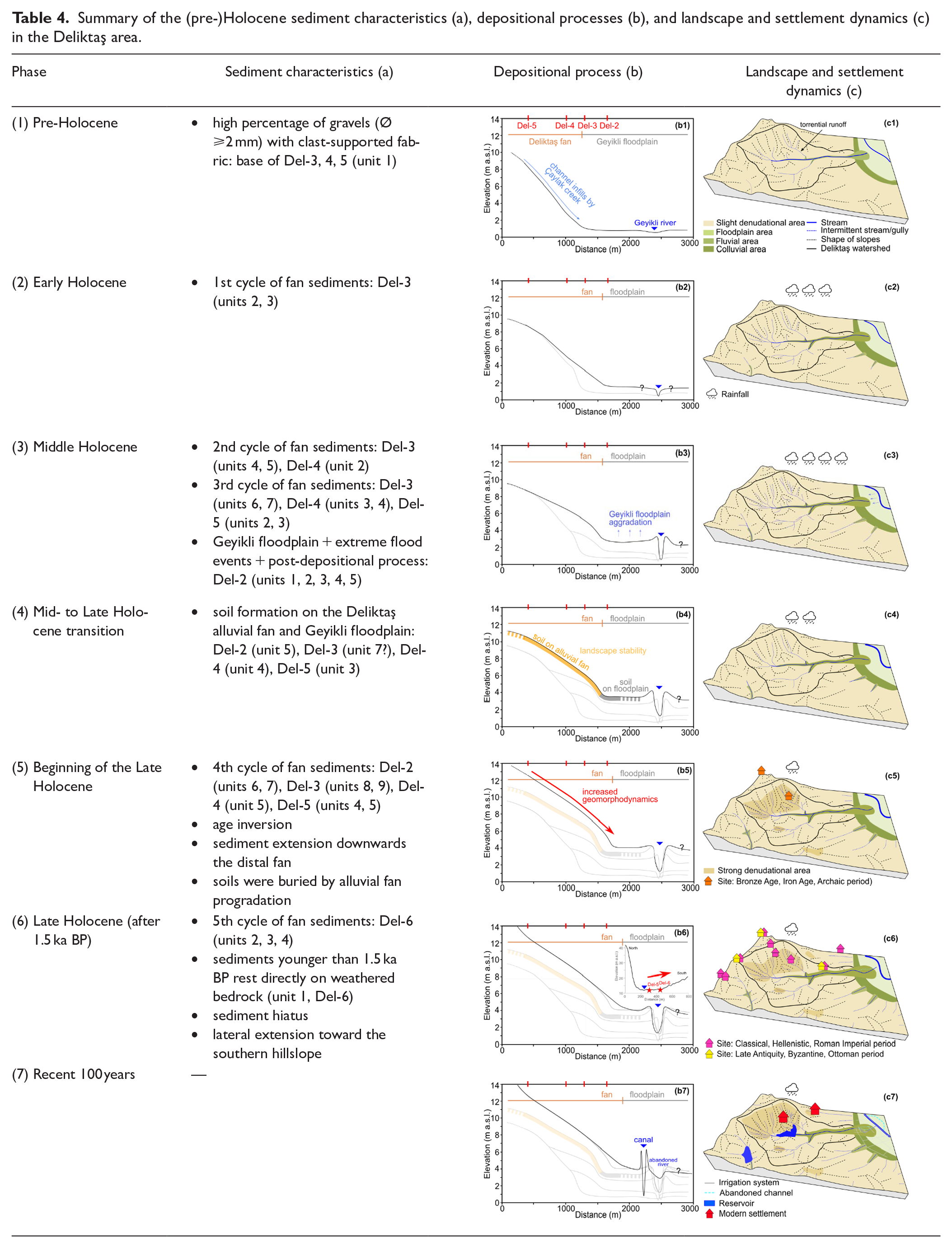
Pre- to Early Holocene (phases 1–2)
The gravel deposits (sub-facies Bc) form the base of profiles Del-3, Del-4, and Del-5 corresponding to channel sediments accumulated by the Çaylak creek (phase 1; Table 4) (cf. Brown, 1997). Locally, channel infills reach up to 3 m thickness (Del-4). The alluvial fan was dominated by channelized flows during this phase (cf. Parker, 1999). At key-profile Del-3, sediments overlying the channel infills date into the Early Holocene (9.0–8.4 cal ka BP, unit 2, 569 cm b.s.; Figure 4A; Table 3), indicating that the channel infills were possibly deposited in the Late Pleistocene. This observation is in line with various reports across the Mediterranean region describing such active channel erosion and subsequent channel infills for the Late Pleistocene (Bintliff, 2002; Vita-Finzi, 1969).
Alluvial fan deposits with changing textures covered these pre-Holocene channel infills (Figure 4A). The first cycle of coarse-textured alluvial fan sediments (sub-facies Bb) and fine-textured alluvial fan sediments (sub-facies Ba) occurs at the middle–distal part of the alluvial fan (Del-3, units 2–3) with a radiocarbon age dating to the Early Holocene (phase 2; Table 4). The change from sediment sub-facies Bb (coarse texture) to sub-facies Ba (fine texture) represents the conditions of surface runoff changing from high energy to low energy (Blair and McPherson, 2009). This might indicate (a) the shifting location of the Çaylak creek channel on the fan causing alternating depositional environments (cf. Blair and McPherson, 1994, 2009) or (b) alternating intensity of flood events (predominantly triggered by varying climate) (Bull, 1991; Dorn, 1994). The hydro-climatic conditions in the eastern Mediterranean region during the Holocene suggest temporal oscillations between wet and dry periods (Eastwood et al., 2007; Finné et al., 2019; Ocakoğlu et al., 2022), directly affecting run-off dynamics (Dorn, 1994) and hereby processes of erosion and deposition (Dusar et al., 2011). The influence of tectonic activity cannot be proven for the Deliktaş catchment where no major Pleistocene faults are known; however, the catchment is located at a horst structure in a tectonically active area, thus surrounded by fault lines (Karacik et al., 2007).
Middle Holocene (phase 3)
Another cycle of coarse- and fine-textured alluvial fan deposits is observed at the key profile Del-3 (units 4–5) and Del-4 (unit 2), both located at the middle fan (Figure 4A). The radiocarbon datings from the upper part of the cycle (Del-3, unit 5, 285 cm b.s.) indicate that the sediments were deposited at least until 5.3 cal ka BP, thus during the Middle Holocene. Later, also during the Middle Holocene, the fine-textured fan deposits at the top of this cycle were covered by an analogous cycle of fan sediments, which extends from the proximal fan (Del-5, units 2–3) to the middle fan (Del-3, units 6–7; Del-4, units 3–4) (Figure 4A). The two cycles together form the third phase (Table 4). These findings indicate (a) a continuous growth of the spatial extent of the Deliktaş alluvial fan since the Early Holocene due to the topography of the channel base, allowing the space for fan growth (Figure 4A) or (b) re-mobilization processes from the proximal toward the distal area of the fan (cf. Van Dijk et al., 2012). Fan growth remained consistent until the beginning of the Late Holocene in the first assumption as indicated by the constant aggradation rate at Del-3 between ca. 9 and 3.5 cal ka BP (89 cm ka−1; Figure 5). Alternatively, repeated re-deposition processes in a fan environment with shifting channels under a climate characterized by strong seasonality with torrential run-off have to be considered, particularly in its proximal area where the incision and backfilling processes are the most prominent during the experiments by Van Dijk et al. (2012).
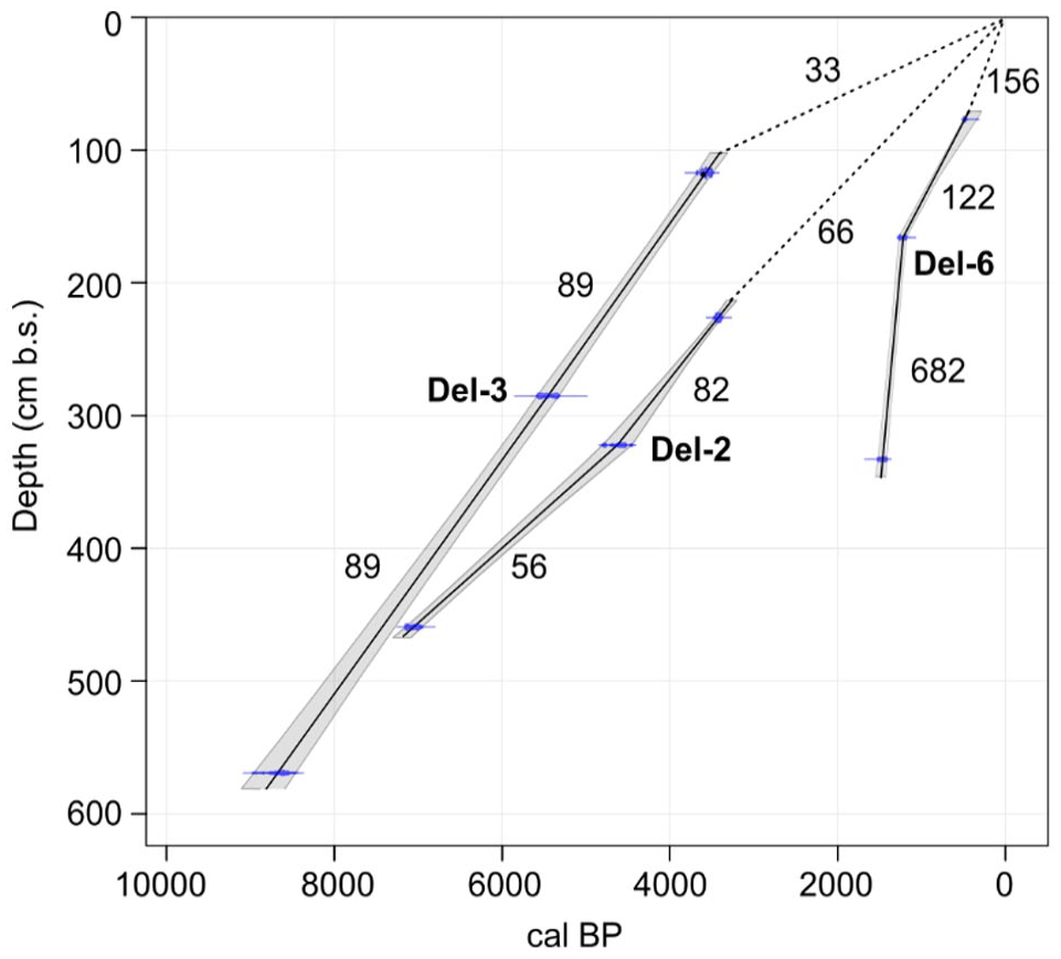
The simplified age-depth modeling of profiles Del-2, Del-3, and Del-6, with the values showing the aggradation rate in cm ka−1 of each section.
Contemporarily (phase 3), the floodplain of the Geyikli river aggraded and prograded to the foreland of the Deliktaş fan, that is, the footslopes of the Karadağ mountain (Del-2; Table 4). This floodplain accumulation (sub-facies Cf) lasted from ca. 7 to 3.4 cal ka BP (ages from Del-2, unit 1, 459 cm b.s., and unit 5, 226 cm b.s.; Table 3), which was occasionally interrupted by stronger Geyikli flood events (sub-facies Csh; Figure 4A) and post-sedimentary influenced by carbonate-rich groundwater tables indicated by Fe-Mn mottles and increased Ca/Ti values in units 3 and 4 (Figure 4A and Supplemental Figure S3, available online) (cf. Goldberg and Macphail, 2006). The interfingering of Deliktaş fan and Geyikli floodplain deposits cannot be proven for this period.
Mid- to Late Holocene transition (phase 4)
At the top of the second cycle during the third phase, the fine-textured alluvial fan deposits are influenced by pedogenic processes (sub-facies sBa; Del-4, unit 4; Del-5, unit 3) indicating stable geomorphodynamic conditions without striking erosion and deposition processes (phase 4; Table 4). Pedofacies sBa in Del-5 dates to 3960–3699 cal yr BP (unit 3, 230 cm b.s.), whereas in Del-3 it was slightly younger with an age of 3683–3486 cal yr BP (unit 7, 117 cm b.s.; Table 3). On the Geyikli floodplain, a layer of paleosol (sub-facies sCf) at Del-2 dates again to a slightly younger age of 3478–3378 cal yr BP (unit 5, 226 cm b.s.; Table 3). These fan–floodplain soil processes indicate locally (at least at the coring locations) reduced landscape dynamics at the transition from the Middle to Late Holocene (at least during ca. 4–3.4 cal ka BP), a long-lasting period that allowed the development of 30–40 cm thick solum (Figure 4A).
Mid-Holocene low geomorphodynamics were also observed at a regional scale, for example, in the nearby Tekkedere catchment around 5–4 cal ka BP (Yang et al., 2023) and the western lower Bakırçay plain (Pergamon micro-region) around 4.3–4 ka BP (Becker et al., 2020). Simultaneously, low accumulation rates are reported during ca. 5.8–3.7 ka BP at Lake Gölhisar, SW Türkiye (Eastwood et al., 2007) and during ca. 4.3–4 ka BP in Pasinler Basin, eastern Türkiye (Collins et al., 2005). Although the phases of low erosion/deposition rate in these studies occurred earlier than that in the Deliktaş catchment, they all potentially correspond to the periods of supra-regionally (eastern Mediterranean) low climatic erosion sensitivity with a reduction in Mid-Holocene precipitation (Finné et al., 2011; Roberts et al., 2011). The contemporary limited human activities might also have facilitated lower geomorphodynamics (Dusar et al., 2011), as it is also the case in the Deliktaş catchment (Table 4).
Beginning of Late Holocene (phase 5)
The Mid-Holocene pedofacies on the Deliktaş alluvial fan and Geyikli floodplain were covered—and by this fossilized—by a Late Holocene cycle of coarse- and fine-textured alluvial fan deposits (Del-2, units 6–7; Del-3, units 8–9; Del-5, units 4–5; Figure 4A). Thus, the fan experienced pronounced progradation, growing downslope faster than upslope (phase 5; Table 4). Old sediments stored along the transportation pathways were reworked as evidenced by the age inversion in Del-5, unit 5 (4290–3699 cal yr BP, 77 cm b.s.), a phenomenon widely discussed for the sediment cascade model in alluvial–colluvial archives (Fryirs, 2013; Fryirs et al., 2007; Lang and Hönscheidt, 1999). Subsuming, for the Deliktaş area, the fifth phase is interpreted as a phase of increased geomorphodynamics coming along with increased erosion and deposition processes (Table 4). Radiocarbon age of 2336–2148 cal yr BP in the middle of this phase (Del-4, unit 5, 85 cm b.s.; Table 3) points to the increase of geomorphodynamics prior to 2.3 cal ka BP. Considering that radiocarbon ages from buried topsoils could represent the maximum age of burial time (Nykamp et al., 2020; Scharpenseel and Schiffmann, 1977), the fifth phase might have predominately continued between ca. 4–3.4 and 2.3 cal ka BP (Table 3) during the beginning of the Late Holocene.
Since this initial Late Holocene phase, the Geyikli floodplain sediments cannot be detected anymore at the sampling locations, prevented by the accumulation of Deliktaş fan and its coinciding spatial growth (Figure 4A; Table 4). The autogenic adjustment of the river channel and floodplain (Croudace and Rothwell, 2015), being reported in the micro-region (Schneider et al., 2015) and western Türkiye (Özpolat et al., 2020), however, cannot be proven in this area.
The intensification of geomorphodynamics, thus, the augmentation of erosion processes in the Deliktaş catchment might be triggered by both human interference and climate change (phase 5; Table 4), as frequently observed in wide areas of the eastern Mediterranean during ca. 5–3 ka BP (Dusar et al., 2011; Kuzucuoğlu et al., 2011; Roberts et al., 2019a, 2019b).
Evidence for settlement activities in the Deliktaş catchment is given by the archeological sites of Zindan Tepe and Hatipler Kalesi (Zimmermann et al., 2015) (Figure 2), which have been used latest since the Bronze to the Iron ages (Supplemental Table S1, available online) (Ludwig et al., 2022). This, together with the ceramic remain found in Del-4, unit 5 (Supplemental Figure S4, available online), suggests human activities that likely affected the soil erosion. This is analogous to multiple studies in the Pergamon micro-region where the Middle to Late Holocene landscape shifted from natural to cultural, including processes of woodland clearing, pasture, and agriculture (Schneider et al., 2017; Shumilovskikh et al., 2016; Yang et al., 2023). Many findings all over the Mediterranean region also emphasize the interrelation between settlement activities and land degradation during the Bronze Age (e.g. Dusar et al., 2011; Jouffroy-Bapicot et al., 2021; Vita-Finzi, 1969, and references therein).
Beyond, rapid climate changes, including the 4.2 and 3.2 ka BP events (Bini et al., 2019; Hazell et al., 2022; Manning et al., 2020; Roberts et al., 2011), under altogether semi-arid conditions (Finné et al., 2019; Wanner et al., 2008) might have amplified torrential run-off (Anderson et al., 2007; Bintliff, 2002) and landscape degradation in the eastern Mediterranean (Dusar et al., 2011). This could have intensified the catchment erosive potential and consequently increased alluvial fan deposition (Butzer, 2005). Such a scarce vegetation cover is documented for the areas around the Deliktaş catchment since ca. 3.5 ka BP (Shumilovskikh et al., 2016, 2022).
In the Mediterranean area, accelerated slope erosion is described at several locations, for example, Arslantepe (eastern Türkiye) (Dreibrodt et al., 2014), albeit few were observed during the time of increased geomorphodynamics in the Deliktaş area (Dusar et al., 2011). This may result from research material bias (Ocakoğlu et al., 2022; Verstraeten et al., 2017) and response time variations among alluvial, fluvial, and lacustrine sediments (Becker et al., 2020; Nykamp et al., 2021; Wanner et al., 2008). Beside the contribution of climate change and human interference, various features in alluvial development and the increase in geomorphodynamics could also be associated with complex natural characteristics (Butzer, 1980; Szabó et al., 2010), for example, initial landform and bedrock/soil type (Butzer, 2005; Fediuk et al., 2019; Szabó et al., 2010), threshold difference in geomorphological locations (or the sediment sources and sinks) (Bakker et al., 2013; Nemec and Kazancı, 1999), and variation in landscape sensitivity to accumulation and erosion (Becker et al., 2020).
Late Holocene (phases 6–7)
Since ca. 1.5 ka BP, sediments were deposited directly on the weathered bedrock at the fan’s proximal zone (Del-6, units 2–4; Figure 4A). This sediment hiatus corresponds to a concomitant higher-energetic process evidenced by the highest aggradation rate among the phases (Figure 5), suggesting a new phase of increased geomorphodynamics (phase 6; Table 4). The (sub)rounded shape of pebbles in Del-6, unit 2 (Figure 4A) confirms transport processes by running water and excludes its origin as debris from mass movements at the slopes (cf. Miall, 2006). This further denotes the lateral upslope extension of the alluvial fan (Table 4). These young sediments exposed in Del-6 were roughly deposited contemporaneously to the valley bottom sediments in the nearby Tekkedere catchment (Yang et al., 2023), probably corresponding to the “Younger Fill” (Vita-Finzi, 1969) in the Mediterranean valleys (Roberts, 2014; Roberts et al., 2019b). The time of erosion should take place after the beginning of the Late Holocene (phase 5: ca. 4/3.4–2.3 ka BP; Table 4) and before the onset of deposition at Del-6 (ca. 1.5 ka BP; Table 3), thus, during the profound transformation from the Hellenistic to Roman Imperial period (300 BCE to 300 CE) in the Pergamon micro-region.
In the rural catchment of Deliktaş and its surroundings, the increased number of archeological sites (Supplemental Table S1, available online; Ludwig et al., 2022) corresponds to this micro-regional development. This increased spatial distribution of human settlements indicates the exploitation of formerly untouched lands (Figure 2), likely for arboricultural, pastoral, and agricultural practices (Shumilovskikh et al., 2016, 2022). This presumably caused fundamental changes in the ecosystem and thereby increased the erosive susceptibility of the landscape, leading to intensified gullying in the Deliktaş catchment. During this period, intensified geomorphodynamics are also observed at various locations in the micro-region (Becker et al., 2020), for example, in the rural catchments of the Geyikli river (Schneider et al., 2013, 2014), the Tekkedere creek (Yang et al., 2023), and in ancient harbor cities and their immediate surroundings (Fediuk et al., 2019; Seeliger et al., 2013, 2019; Shumilovskikh et al., 2016).
In the Deliktaş area, only one cycle of alluvial sediments was observed during the Late Holocene (Figure 4A) and is in chronological order with the boost of archeological sites (Ludwig et al., 2022) (phase 6; Table 4). In contrast, in the nearby Tekkedere catchment, several alluvial cycles were observed for the same period (Yang et al., 2023); the difference may be related to a more continuous settlement of the Tekkedere catchment at multiple locations since the Bronze Age (Ludwig, 2020a; Michalski, 2021), beyond the diversity in land use or landform.
Since the 20th century, the construction of the irrigation system and reservoir remarkedly changed the hydrological and geomorphological conditions in the Deliktaş area (phase 7; Table 4). The Geyikli river was straightened to a canal (Doğramacı canal) with embankments (Schneider, 2014). Both the Deliktaş fan and the adjoining Bakırçay plain owe well-developed irrigation systems and abandoned (distributary) channels (Figure 2).
Conclusions
To improve the understanding of the geomorphological history of alluviation, pedogenesis, and erosion, and their driving factors in rural areas of the ancient city of Pergamon, we integrate geomorphological observation in the Deliktaş catchment and the receiving Geyikli river, analyses of alluvial fan and floodplain sediments, and radiocarbon datings. The highly changing sediment texture in the five profiles depicts that the landscape experienced at least seven phases of profoundly different geomorphodynamics. Deliktaş channel sediments deposited in the Late Pleistocene were covered by sediments of an aggrading alluvial fan during the Early–Middle Holocene. Middle Holocene fossil soils on the Deliktaş fan and Geyikli floodplain indicate landscape stability. An accelerated fan growth and hereby a major increase in geomorphodynamics (phase 5) during ca. 4–2 ka BP coincides with the onset of local settlement activities on hitherto untouched lands under the supra-regional aridization with rapid climate changes, possibly including the 4.2 and 3.2 ka BP drought events. Consequences of soil erosion processes on a local scale, that is, the first/second-order catchments, are soil degradation and accelerated growth of fan deposits at their confluence to the foreland, and – on a regional scale – floodplain aggradation such as that of Geyikli and Bakırçay rivers (Becker et al., 2020, 2022b; Schneider et al., 2015).
Pronounced sediment hiatus and lateral extension of fan sediments might indicate increased geomorphodynamics before 1.5 ka. The contemporarily increased number of archeological sites in the Deliktaş area suggests that land use expanded largely to more untouched hillslopes to meet the demand of a growing population in the city of Pergamon and its micro-region, especially during the Roman Imperial period (Laabs and Knitter, 2021). However, uncertain sedimentological and especially chronological results hinder a clear relation between the phases of increased geomorphodynamics in the last 2.5 ka and the major phase of human activities, that is, the transformation of the Pergamon micro-region between the Hellenism and the Roman Imperial Period. On the contrary, our results indicate a more pronounced increase in geomorphodynamic activity since the beginning of the Late Holocene. This phenomenon is also observed in the Tekkedere catchment (Yang et al., 2023) in the vicinity of the Deliktaş catchment, but not generally in all parts of the micro-region (Becker et al., 2020), such as the harbor of Elaia which silted up in the first millenium CE (Seeliger et al., 2013, 2019). Thus, intra-micro-regional variabilities, such as relief, bedrock, and human activities (Yang et al., 2021), are important aspects to understand the geomorphodynamic pattern in a micro-region and wider regions such as the eastern Mediterranean.
Supplemental Material
sj-docx-1-hol-10.1177_09596836231185837 – Supplemental material for Holocene geomorphodynamics of a rural catchment in the Pergamon micro-region (eastern Mediterranean)
Supplemental material, sj-docx-1-hol-10.1177_09596836231185837 for Holocene geomorphodynamics of a rural catchment in the Pergamon micro-region (eastern Mediterranean) by Xun Yang, Fabian Becker, Moritz Nykamp, Bernhard Ludwig, Mehmet Doğan and Brigitta Schütt in The Holocene
Footnotes
Acknowledgements
We wish to express our special thanks for the permission and kind support from the Ministry of Culture and Tourism of the Republic of Türkiye. We thank Yalçın Yılmazer (Directorate Museum Bergama) who took part in the fieldwork as a government representative. Geography students from Ege Üniversitesi İzmir (Hakan Güler, Nami Yurtseven, Minel Korkmaz, and Yaren Bozoğlu) are appreciated for their assistance in the fieldwork of coring/sampling and laboratory analyses. We also thank Tom Dauer from Freie Universität Berlin for additional laboratory analyses. In addition, we acknowledge the help of colleagues from the DAI (Felix Pirson, Ulrich Mania, and Nicole Neuenfeld), Manisa Celal Bayar Üniversitesi (Güler Ateş), and Bergama Museum. We acknowledge the constructive comments and suggestions from two anonymous reviewers that helped to improve the manuscript and thank the Editor John A. Matthews for handling our manuscript and considering it for publication.
Funding
The author(s) disclosed receipt of the following financial support for the research, authorship, and/or publication of this article: The study is funded by Deutsche Forschungsgemeinschaft (German Research Foundation; grant number 419349690). X. Yang received a scholarship from the China Scholarship Council (grant number 201906190216). The research is conducted within the frame of the project Die Transformation der Mikroregion Pergamon zwischen Hellenismus und römischer Kaiserzeit (The Transformation of the Pergamon Micro-Region between the Hellenistic Period and the Roman Imperial Period, ![]() ) and the Pergamon Excavation Project of the Istanbul Department of the German Archeological Institute (DAI) of which the license is held by Professor Felix Pirson.
) and the Pergamon Excavation Project of the Istanbul Department of the German Archeological Institute (DAI) of which the license is held by Professor Felix Pirson.
Supplemental material
Supplemental material for this article is available online.
References
Supplementary Material
Please find the following supplemental material available below.
For Open Access articles published under a Creative Commons License, all supplemental material carries the same license as the article it is associated with.
For non-Open Access articles published, all supplemental material carries a non-exclusive license, and permission requests for re-use of supplemental material or any part of supplemental material shall be sent directly to the copyright owner as specified in the copyright notice associated with the article.