
Abstract
To reconstruct naturally and anthropogenically induced environmental change in SE Europe since the Little Ice Age, we have examined five partially varved sediment cores from coastal Lake Vouliagmeni, Greece. Our reconstructions are based on a multi-proxy approach including microfacies analysis, X-ray fluorescence core scanning, radionuclide dating (210Pb, 137Cs, and 241Am), and palynological analysis (pollen, spores, and dinoflagellate cysts). A 131 -cm-long composite record that encompasses the past c. 300 years reveals 181 varves of endogenic and mixed clastic-biogenic types. The formation of these varves was controlled by seasonal variability in clastic input and primary productivity. The non-varved intervals consist of homogenous lake sediments and turbidite deposits. Based on a chronology developed through radionuclide dating, varve counting and exclusion of turbidites from the sequence, we have compared our proxy data with meteorological data and historical records of earthquakes and human activities. Our results suggest that the surroundings of Lake Vouliagmeni experienced relatively wet conditions during the late solar Maunder Minimum (1645–1715 AD) and relatively dry conditions during the Dalton Minimum (1790–1830 AD), which highlights the hydroclimatic heterogeneity in SE Europe during the Little Ice Age. The evaluation of historical documentation suggests that the majority of the turbidites is related to lake-slope instabilities following earthquake shocks. Human impact on Lake Vouliagmeni includes (i) a change in aquatic biota following the artificial connection of the lake to the sea at c. 1880 AD, and (ii) expansion of agricultural areas and reduction of natural forests around the lake due to population growth over the past 300 years.
Keywords
Introduction
The impact of humans on terrestrial ecosystems intensified strongly with the establishment of agriculture during the mid-Holocene and rose to unprecedented, ever-increasing levels over the past century until today (e.g. Anthony et al., 2014; Kaniewski et al., 2013). At the same time, there is strong evidence that environmental forcing has been instrumental in a number of sociocultural transitions during the past (e.g. Roberts et al., 2018; Weiss, 2000; Weninger et al., 2009) and also poses a threat to the stability of modern societies (e.g. Carleton and Hsiang, 2016; Degroot et al., 2021). Deciphering potential interactions between environmental change and human activity in the past critically hinges upon the study of sedimentary records at very high (i.e. sub-decadal) resolution that enables alignment of the obtained proxy data with historical documentation (e.g. Büntgen et al., 2011, 2016; Słowiński et al., 2021). In that context, sedimentary archives from lakes play a prominent role. They typically exhibit sufficiently high sedimentation rates to allow high-resolution analyses (years to decades; e.g. Birks and Birks, 2006; Cohen, 2003), can provide robust chronologies and insight into seasonality aspects if annually laminated (Brauer, 2004; Ojala et al., 2012; Zolitschka et al., 2015), and are highly sensitive recorders of human activities as lake shores have been in the focus of habitation since the establishment of the earliest cultures (e.g. McIntosh, 2009; Menotti, 2004).
The Aegean Sea region in SE Europe is a key area for unraveling the extent of human influence on natural ecosystems and vice versa. Being home to some of the earliest cultural centers in human history (e.g. Chapman and Souvatzi, 2020; Perlès, 2001) the region has a vibrant sociocultural past with a rich documentary record (e.g. Davies and Davis, 2007; Haldon, 2009; Shepard, 2008). At the same time, the Aegean region is exceptionally sensitive not only to short-term climate change due to its intermediate position between the higher- and lower-latitude climate systems (Lionello et al., 2012), but also to tectonic activity that can rapidly alter the landscape (e.g. Galanidou et al., 2020; Sakellariou and Galanidou, 2016). Despite the wealth of available paleoenvironmental records for the Holocene of the Aegean region (e.g. Finné et al., 2011; Luterbacher et al., 2012; Weiberg et al., 2016), the general lack of records of sub-decadal-scale temporal resolution and robust chronologies has yet precluded a deeper understanding of the interaction between human activities and natural processes.
Annually laminated (i.e. varved) sediment records, which allow for direct and incremental dating of climatic and environmental archives at even seasonal resolution (Brauer, 2004; Zolitschka et al., 2015), are scarce in SE Europe (Ojala et al., 2012; Schimmelmann et al., 2016). Such records have yet been documented from only three sites in the broader Aegean region, that is, the Butrint (Ariztegui et al., 2010; Morellón et al., 2016) and Etoliko (Koutsodendris et al., 2015; Vött et al., 2007) lagoons on the Ionian coast, and Lake Vouliagmeni in the Gulf of Corinth (Emmanouilidis et al., 2020, 2022; Figure 1). The recently emerged record from Lake Vouliagmeni is in close proximity to important sociocultural centers of the past millennia (Davies and Davis, 2007; Simantoni-Bournia and Mendoni, 1999) and hence it holds potential to shed light into human interaction with natural processes in the Aegean region. However, uncertainties remain regarding the annual nature of the laminations and stratigraphic completeness of this record due to the yet sporadic analysis of sediment microfacies and the presence of deformation structures as reported by Emmanouilidis et al. (2020, 2022). These uncertainties may have contributed to the evidence for a consistently relatively wet Little Ice Age at Lake Vouliagmeni (Emmanouilidis et al., 2022) in comparison with the general hydroclimate heterogeneity documented in other lake and dendrochronological datasets from SE Europe for this period (e.g. Koutsodendris et al., 2017; Ljungqvist et al., 2016; Touchan et al., 2005).
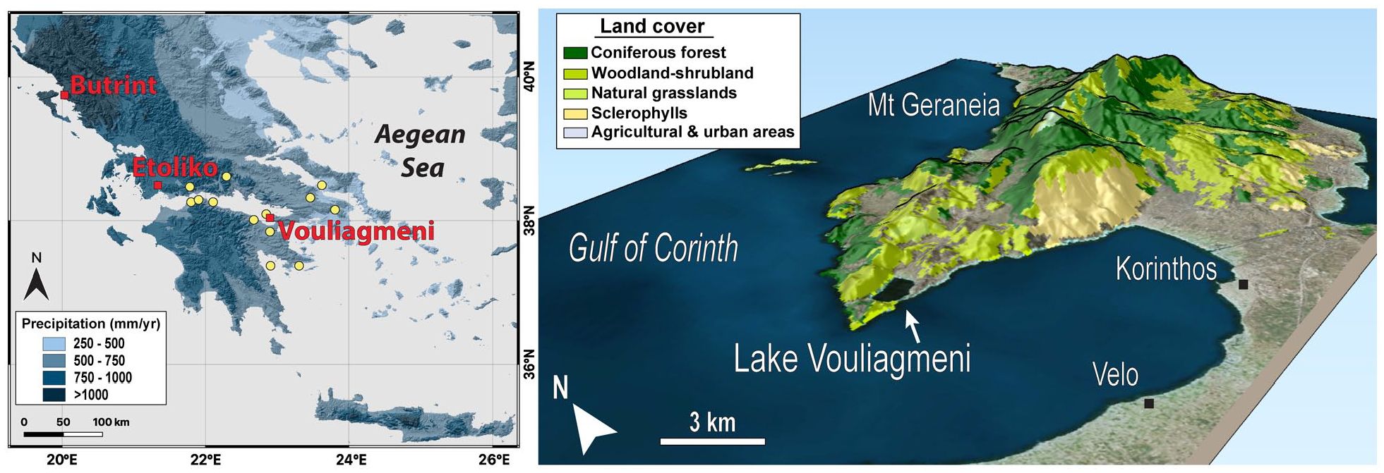
Location of Lake Vouliagmeni and other key sites discussed in the text. Left panel: Relief map of the Greek Peninsula with precipitation data for the period 1970–2000 (Fick and Hijmans, 2017). Right panel: Major vegetation and land- use zones in the eastern Gulf of Corinth based on the Corine Land Cover 2018 (European U, Copernicus Land Monitoring Service 2022, European Environment Agency, 2022; Version 2020_20u1). The yellow dots mark the epicenters of the earthquakes listed in Table 1.
List of turbidite layers recorded in Lake Vouliagmeni and major earthquakes that have occurred in the Gulf of Corinth region during the time interval covered by of our record as potential trigger mechanisms for slope instabilities.
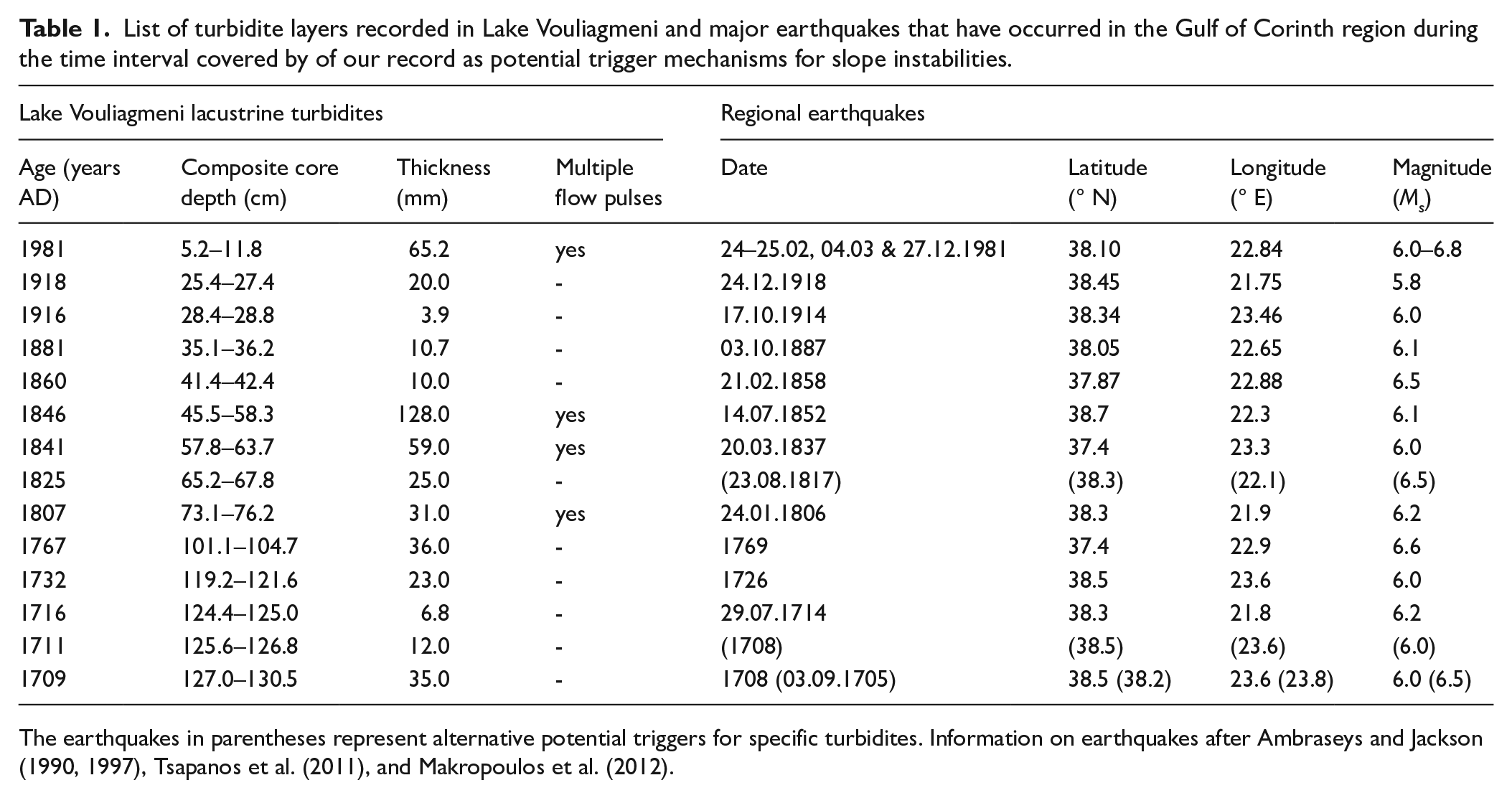
The earthquakes in parentheses represent alternative potential triggers for specific turbidites. Information on earthquakes after Ambraseys and Jackson (1990, 1997), Tsapanos et al. (2011), and Makropoulos et al. (2012).
In order to decipher the interaction between human activities and natural processes in the Aegean region, we here study new core material from Lake Vouliagmeni to identify the sedimentological characteristics over the past c. 300 years through microfacies analysis, inorganic geochemistry, and radionuclide dating. Moreover, we carry out palynological analysis (pollen, spores and dinoflagellate cysts) to reconstruct terrestrial and aquatic ecosystem dynamics. Finally, we integrate our proxy data with historical records of earthquakes and human activities as well as with instrumental meteorological data to achieve a deeper understanding of the processes behind the deposition of the sequence.
Regional setting
Lake Vouliagmeni is located on the southern shore of the Perachora Peninsula in the eastern Gulf of Corinth, Greece (Figure 1). Formed within a tectonic depression (Maroukian et al., 2008), the lake has a surface area of ∼1.7 km2 (∼1880 x 930 m) and a maximum depth of ∼49 m (Katsanevakis, 2006). Lake Vouliagmeni is surrounded by a hilly topography with altitudes of up to 250 m and located close to the westernmost margin of the Geraneia Mountains (maximum elevation: 1350 m). Low ridges (<10 m) separate the lake from the Gulf of Corinth to the west, and an artificial channel (∼85 m long, ∼18 m wide, ∼1 m deep) that was built in the 19th century provides a connection to the sea (Katsanevakis, 2006, 2007a). Whereas wave activity in the lake is low as a result of the sheltered morphology (Katsanevakis, 2007b), strong tidal currents affect Lake Vouliagmeni through the artificial channel leading to water-level changes of up to 50 cm (Vardala-Theodorou and Nicolaidou, 2007).
The lake’s physicochemical parameters are based on scarce observations carried out during 1992–1995 (Vardala-Theodorou and Nicolaidou, 2007) and 2003–2004 (Katsanevakis, 2006). Surface-water temperatures are 6
Lake Vouliagmeni is fed by the Perachora stream (∼9.5 km long) and its tributaries that drain a total surface area of ∼12 km2 (Duffy et al., 2015; Maroukian et al., 2008). Geologically, the catchment area is mainly composed of limestones and, to a lesser extent, Plio/Pleistocene marine conglomerates, sandstones and marls, and Holocene alluvial deposits (Duffy et al., 2015; Maroukian et al., 2008). Climatically, the area is characterized by typical Mediterranean conditions with warm, dry summers and mild, wet winters. According to instrumental data from the two closest meteorological stations in the towns of Korinthos and Velos (Figure 1), the mean annual temperature is 18.1°C, the mean summer temperature is 27.0
The hills and mountains to the east of Lake Vouliagmeni (Figure 1) are characterized by a rich flora and diverse plant habitats (Constantinidis, 1997). Elevations of up to c. 300 m are dominated by Pinus halepensis Mill., Mediterranean sclerophylls (such as Arbutus adrachne L., Juniperus phoenicea L., Myrtus communis L., Pistacia lentiscus L., Phillyrea latifolia L., Quercus coccifera L., and Quercus ilex L.), and phrygana (such as Calicotome villosa (Poir.) Link, Cistus sp., and Sarcopoterium spinosum Spach). Abies cephalonica Loudon dominates at elevations >700 m, and Platanus orientalis L. and Nerium oleander L. grow along seasonal rivers and streams. Finally, cultivated plants in the catchment area of Lake Vouliagmeni include Olea europaea L., Vitis vinifera L., and, to a lesser extent, Amygdalus communis L., Juglans regia L., Triticum sp., and Hordeum vulgare L. (Constantinidis, 1997).
Material and methods
Coring at Lake Vouliagmeni was conducted in July 2015 using a UWITEC short-core system from a small catamaran platform. Plastic (PVC) liners were carefully hammered into the sediment with a weight on a rope; the retrieved sediment cores were subsequently cut lengthwise in the laboratory and split into two halves for analysis. Five cores of 89–139 cm length (labeled LVL15-1 to LVL15-5; Figure 2) were recovered from the deepest part of the lake at a water depth of ~49 m, with coordinates between 38° 1′ 33–38° 1′ 43″ N and 22° 52′ 49″–22° 53′ 14″ E. Core LVL15-4 is the longest core retrieved during this campaign; however, it lacks the uppermost c. 10 cm as they have been recovered in the other four cores, and its stratigraphy is partially disturbed between c. 30 and 70 cm (Figure 2). Hence, a composite record was developed from cores LVL15-1 and LVL15-4 considering (i) the undisturbed sediment sequence of LVL15-1 and (ii) the macroscopically similar thickness of the distinct sedimentary units (Figure 2). Specifically, core LVL15-1 was used for the uppermost 83.5 cm of the composite record, whereas core LVL15-4 was used for the rest of the composite record down to 131 cm (Supplemental Figure 1). The transition from core LVL15-1 to LVL15-4 was based on a marker layer identified during microfacies analysis. Specifically, microfacies analysis was carried out for the 0–88.5 cm interval of core LVL15-1 and the 73–139 cm interval of core LVL15-4. Radionuclide measurements were carried out at the uppermost 40 cm of core LVL15-1. Both cores were analyzed with an X-ray fluorescence (XRF) core scanner, and were sampled for palynological and loss on ignition analyses. In the results and discussion sections below, all proxy data are presented on the composite depth scale.
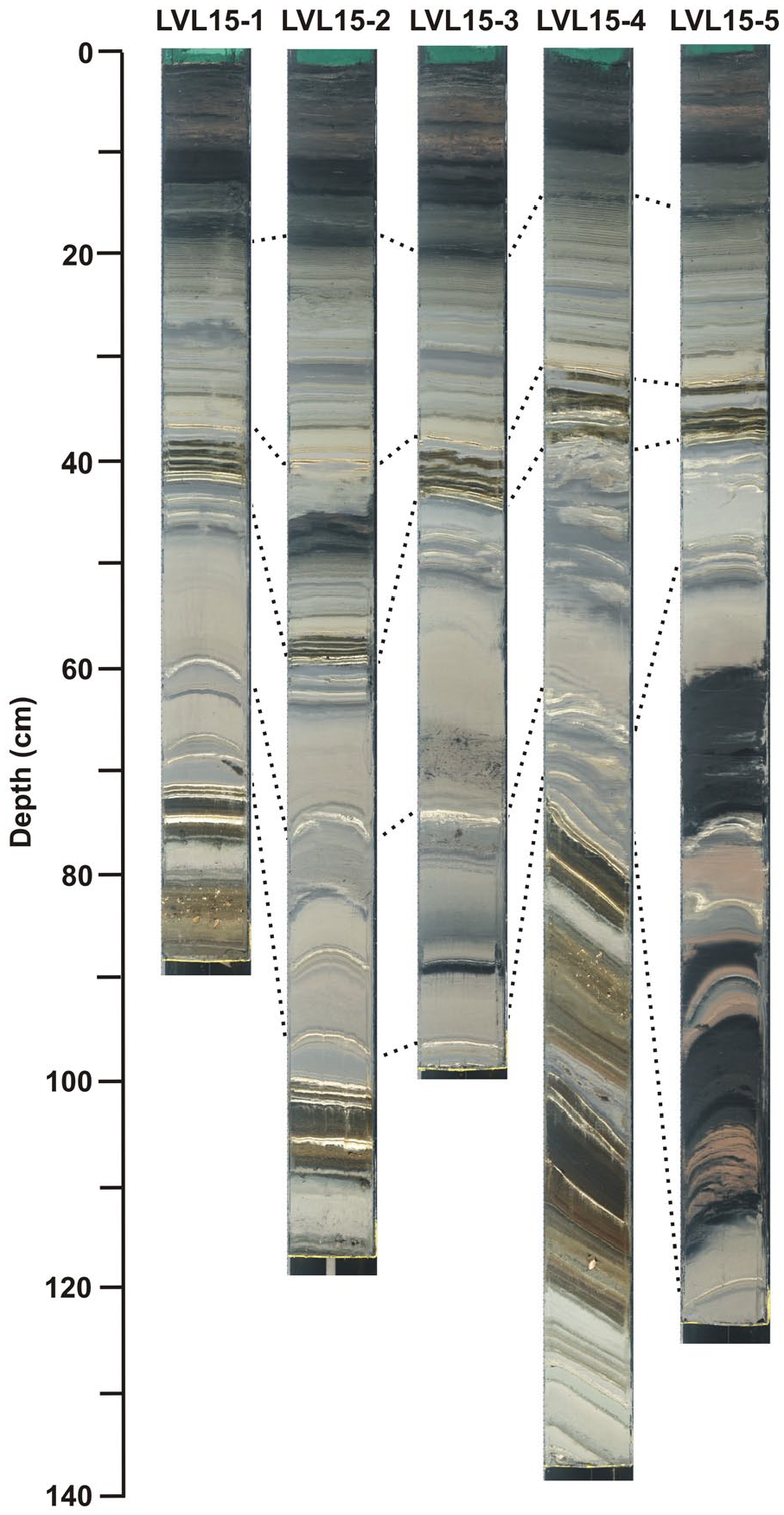
Photographs of the cores retrieved from Lake Vouliagmeni. Dashed lines indicate marker layers, highlighting the distinctively different sedimentation rates among the cores.
Radionuclide dating
For radionuclide dating (i.e. 210Pb, 214Pb, 214Bi,137Cs, and 241Am) the uppermost 40 cm composite depth were sampled in 1 cm layers. The samples were freeze-dried (dry-weight range: 7–32 g), homogenized and placed in cylindrical transparent polystyrene containers that were sealed with an aluminum-composite foil in order to keep the samples Radon-tight (Putyrskaya et al., 2015). The activity concentrations of the radionuclides were measured gamma-spectrometrically after at least 3 weeks, during which 214Pb and 214Bi reached a secular equilibrium with 226Ra, using Canberra-Eurisys Broad Energy Germanium (BEGe-5030) detectors at the University of Applied Sciences Ravensburg-Weingarten. The activity concentrations were calculated with the LabSOCS (Canberra) calibration software taking into account the self-absorption of γ-rays in both samples and beakers as well as the summation-effects due to simultaneous emissions of several gammas from one nuclear decay. Measuring time was up to 24 h per sample until counting uncertainties of <5% were achieved. To establish a depth-age relation in the sediment core we used the piecewise Constant Rate Supply model (CRSpw; Appleby PG, 2001) as previously applied in a number of studies on lake-sediment dating (e.g. Klemt et al., 2021; Putyrskaya et al., 2015, 2020).
Microfacies analysis and varve counting
Thin sections for microfacies analysis were prepared following standard techniques, including freeze-drying, impregnation with Araldite® epoxy resin (Brauer and Casanova, 2001), and sawing and grinding of the impregnated sediment blocks. A successive sequence of 19 large-format (120 mm×35 mm) thin sections with a continuous overlap of 2 cm was studied using a petrographic microscope at 25–320x magnification with plain parallel and cross-polarized light allowing for precise lithological descriptions, thickness measurements of the individual layers, and varve counting (e.g. Brauer and Casanova, 2001; Koutsodendris et al., 2011). For the homogeneous sections, the varve chronology was developed considering mean sedimentation rates and using the average thicknesses of the closest five varves.
Geochemical analyses
XRF geochemical analysis for the elements Si, S, Cl, K, Ca, Ti, Mn, Fe, Br, and Sr was conducted on the split core surfaces using an ITRAX core scanner equipped with a chromium X-ray tube at German Research Center for Geosciences (GFZ) Potsdam, Germany. Measuring settings were 10 s count time, 30 kV tube voltage, 30 mA tube current, and 200 μm step size in order to allow insight into (sub-) annual timescales. Replicate measurements (threefold) have been obtained from selected positions down core to cover the sediment compositions of each core section, which were used to calculate the relative standard error. The elements free of zero-values and a relative standard error of <20% were selected for this study.
To minimize sample-geometry effects related to differences in water content, surface irregularities, and sediment density, raw-element intensities (cps) were normalized by center-log-ratio (CLR) transformation (Weltje et al., 2015). Element correlations were explored using a principal component biplot of the CLR-transformed data. To reduce the influence of noisy element records, the elements were scaled by the inverse of the uncertainty (confidence limits 95%) that were calculated from the replicate measurements. Finally, groups with similar sediment composition were obtained by hierarchical clustering of the XRF data. All statistical analyses were performed using the Xelerate software package (Weltje et al., 2015).
The organic-matter content of the cores was determined by measuring loss on ignition (LOI) for 90 samples following the protocol of Heiri et al. (2001). Bulk samples were freeze-dried for 24 h, and 1 g of the dried, homogenized sediment was dry-ashed at 550°C for 4 h and subsequently weighed. The weight lost during burning at 550°C was used to estimate the organic-matter content of the sample (LOI550). Based on the age model (compare Section “Chronology”), the LOI550 dataset has a temporal resolution of 5 years (range: 2–11 years).
Palynological analysis
A total of 36 samples was analyzed palynologically using ∼4 cm3 of sediment volume every 4 cm from the composite record. Based on the age model (compare Section “Chronology”), the palynological dataset has a temporal resolution of 14 years (range: 3–35 years). Palynological sample preparation followed standard techniques previously applied to lagoonal sediments (e.g. Koutsodendris, 2022; Koutsodendris et al., 2017) comprising freeze-drying, weighing (range of sample dry weights: 0.5–2.6 g), treatment with HCl (<30%) and HF (40%), sieving (10 μm), and mounting of the residues on glass slides using glycerin jelly. To calculate palynomorph concentrations, all samples were spiked with Lycopodium spores (Batch Nr. 3140) prior to processing. An average of 613 pollen grains (range: 292–2211) was counted per sample; moreover, dinoflagellate cysts were registered in each sample (range: 0–109 cysts). Pollen percentages were calculated excluding pollen from aquatic plants and fern spores as well as Pinus pollen because of its natural over-representation in lake sediments when this taxon grows in close proximity to the lake (e.g. Traverse, 2007) as is the case for Lake Vouliagmeni.
Results
Chronology
The vertical distribution of 137Cs in the core material reveals two distinct peaks at 4–5 cm and 17–18 cm composite depth, with activities of 52.3 ± 0.9 Bq/kg and 19.6 ± 0.3 Bq/kg, respectively (Figure 3). The lower peak also coincides with the highest concentrations of 241Am in the core material (2.1 ± 0.2 Bq/kg). The 137Cs and 241Am peaks at 17–18 cm can be firmly assigned to the maximum intensity of nuclear weapon testing in 1963 AD that left a strong imprint on sedimentary records globally (Appleby, 2001). Moreover, the 137Cs peak at 4–5 cm is assigned to the radioactive fallout of the Chernobyl accident in 1986 AD that was widely distributed over Greece (Petropoulos et al., 2001). The downcore distribution of 210Pb provides additional age control for the Lake Vouliagmeni record based on the CRSpw model (Appleby, 2001). Specifically, the oldest sample dated by 210Pb at a depth of 30 cm has an age of 103.8 ± 7.4 years (Figure 3); after correction for the coring date (July 2015), this corresponds to 1911 AD ± 7.4 years.
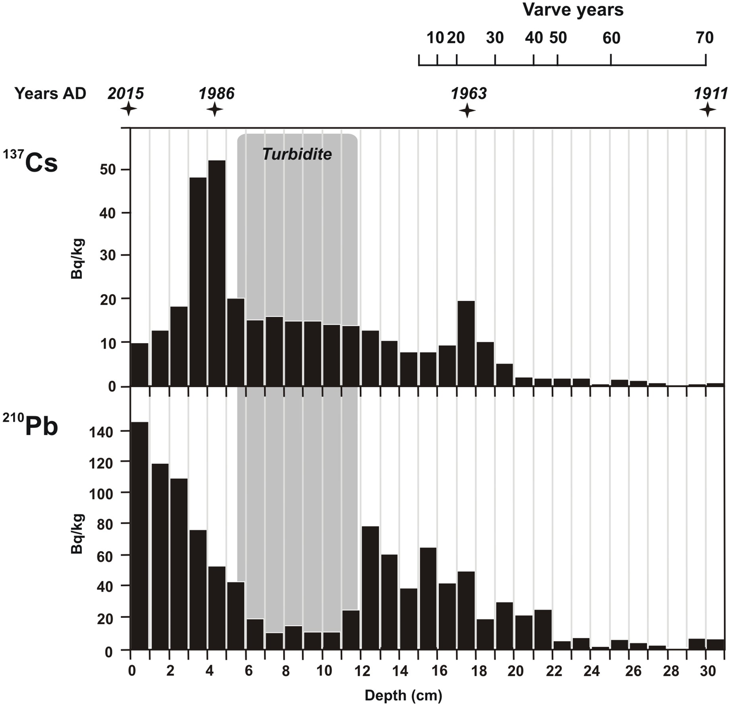
Radionuclide activity concentrations (in Bq kg-1 decay-corrected to the date of sampling) plotted against composite core depth (cm) and varve years. Stars mark chronological tie-points derived by the radionuclide activity concentrations.
Prior to age-model development based on the radionuclide data, all turbidite layers (see Section “Lacustrine turbidites”) were removed following the approach previously applied to the laminated record from Lake Butrint (Ariztegui et al., 2010; Morellón et al., 2016). The calculated mean sedimentation rates between the age-control points are 1.9, 2.8 and 1.6 mm/year for the periods 1911–1963 AD, 1963–1986 AD and 1986–2015 AD, respectively. Importantly, these age-control points strongly suggest an annual nature of the laminations: The uppermost 30 cm of the sequence span 104 years (1911–2015 AD), a duration that is in agreement with the number of lamination couplets in the same interval (see Section “Seasonal sedimentation processes and varve formation”). The annual character of the laminations allows us to extend the core chronology across the laminated intervals beyond the oldest age-control point at 1911 AD. Altogether, the combination of independent radiometric dating techniques and varve counting indicates that the composite record from Lake Vouliagmeni spans from 1710 to 2015 AD and thus has a duration of 305 years.
Sedimentology
Based on the macroscopical description of all cores recovered from Lake Vouliagmeni, three major sedimentary facies are identified, that is, (i) finely laminated, (ii) coarsely laminated and partly graded, and (iii) homogeneous. While the finely laminated intervals have similar thicknesses in the individual cores, the thicknesses of the coarsely laminated intervals vary considerably (Figure 2). To assess the sedimentation processes controlling the deposition of these facies types, their structures and compositions were studied based on microfacies and geochemical analyses on the composite core record. This allowed us to confirm the annual character of the finely laminated sediments and to differentiate them from the coarsely laminated and partly graded turbiditic deposits.
Finely laminated facies
The finely laminated facies consists of discrete, mm- to sub-mm thick laminae that form couplets of light and dark layers (Figure 4). Based on the microfacies analysis, two types of light and dark couplets occur.
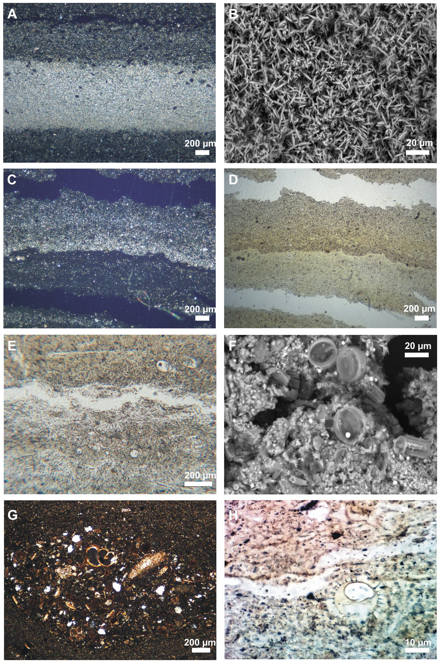
Photographs of varve microfacies documented in the Lake Vouliagmeni cores. (a) Endogenic varve consisting of aragonite and organic-rich sublayers photographed under cross-polarized light. (b) Scanning electron photograph of aragonite crystals. (c and d) Mixed clastic-biogenic varve under cross-polarized (left) and parallel-polarized (right) light. (e) Diatom-rich sublayer under parallel-polarized light. (f) Scanning electron photograph of a sublayer rich in Thalassiosira sp. diatoms. (g) Lens of coarse-grained detrital material and benthic mollusks within a dark layer deposited during the autumn/winter seasons. (h) Dinoflagellate cyst of the genus Echinidinium.
Lam-I type (121 couplets) is found between 104 and 27 cm composite depth, corresponding to the period between 1710 and 1918 (± 7 years; Figure 5). The light layers consist almost exclusively of μm-long, idiomorphic star-shaped aragonite crystals (Figure 4a and b), and exhibit high Ca and Sr contents. In contrast, the dark layers mainly consist of amorphous organic matter as well as pennate and centric diatom frustules in varying abundances (Figure 4c and d). Bivalve and ostracod shells as well as fine-grained minerogenic material are also observed. The dark layers are characterized by high Fe, K, Si, and Ti contents. Variations in the main characteristics of the Lam-I type laminations are observed throughout the record. Specifically, (i) the dark layers deposited in c. 1815–1825 consist solely of amorphous organic matter, lacking pennate diatoms frustules as well as bivalve and ostracod shells; (ii) the dark layers deposited in c. 1840–1845 consist predominantly of fine-grained minerogenic content, virtually lacking organic components; (iii) the light layers deposited in c. 1730–1735, 1845–1860, 1865–1880, and 1890–1920 are characterized by the virtual absence of aragonite and the dominance of fine-grained minerogenic material, with occasional occurrences of gastropod shells and small centric diatom frustules. Altogether, Lam-I facies represents minerogenic/organic-rich couplets with a mean thickness of 2.15 mm (Figure 5). The mean thickness of the minerogenic layers is 1.19 mm, within which the aragonite layers are on average 0.49 mm thick and the mean thickness of the organic-rich layers is 1.17 mm.
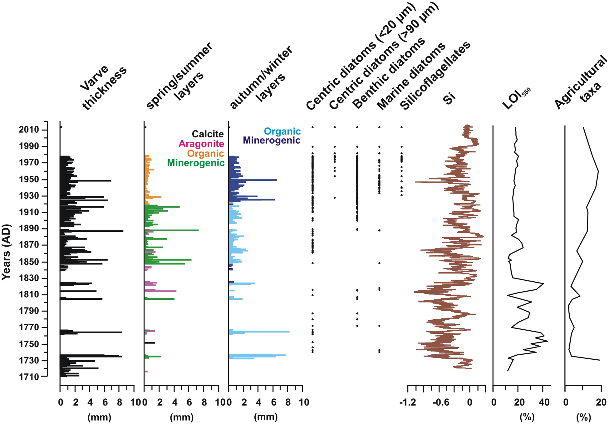
Selected abiotic and biotic proxy data from Lake Vouliagmeni spanning the past c. 300 years. The varve-related information is derived from the microfacies analysis. LOI550: Loss on Ignition at 550°C. All data are plotted against age after removal of the turbidite layers.
Lam-II type (60 couplets) is found between 25 and 15 cm composite core depth, corresponding to the period between 1919 and 1978 (± 7 years; Figure 5). It consists of alternating organic-diatomaceous (light) and minerogenic (dark) layers lacking aragonite. The diatomaceous (light) layers are predominantly composed of small centric diatom frustules (<20 μm) of the holoplanktic marine genus Thalassiosira sp. and elongated pennate diatoms often forming distinct sub-layers (Figure 4e and f). Freshwater centric (Aulacoseira sp. and Stephanodiscus sp.) and marine (Chaetoceros sp.) diatom frustules, silicoflagellate skeletons (Dictyocha fibula) that occasionally form distinct sub-layers, dinoflagellate cysts (Figure 4h), and varying amounts of fine-grained minerogenic material are also observed within the light layers. The overlaying minerogenic (dark) layers are dominated by fine-grained minerogenic material containing minor amounts of small centric and pennate diatoms, and silicoflagellates. In both light and dark layers, lenses of coarse-grained detrital material as well as bivalve, gastropod and ostracod shells are observed (Figure 4g). The Lam-II couplets show lower geochemical variability than those of the Lam-I type, with Cl, K and Si contents being somewhat more variable than the rest of the measured elements (e.g. Ca, Fe, Ti). The mean thickness of the Lam-II type laminations is 1.73 mm (Figure 5), with the minerogenic layers being generally thicker (mean: 1.35 mm) than the organic diatomaceous layers (mean: 0.45 mm).
Coarsely and partly graded laminated facies
This facies consists of discrete layers of minerogenic material, with sharp lower boundaries lacking erosional structures, and often distinct fining-upward grading. A total of 23 layers with thicknesses from 0.3 to 7.6 cm (mean: 2.1 cm; Stdev: 1.8) have been identified throughout the sequence; they are marked by grading from coarse silt and fine sand (<150 μm grain size) to clay and fine silt. Six layers exhibit multiple fining-upward successions, in which the fining is interrupted by another coarse sub-layer, probably representing multiple flow pulses during the deposition of one of those layers. Gastropod and bivalve shells and shells fragments as well as amorphous organic matter are occasionally present, often forming lenses within the detrital material. Whereas the palynological data show low total pollen concentrations within the graded layers, this facies is associated with elevated abundances in Pinus and Cichorioideae pollen, and Pseudoschizaea algal remains (Figure 6). In addition, this facies lacks variability in the XRF-based elemental geochemical data (Figure 6 and Supplemental Figure 1), and shows constant 137Cs concentrations and very low unsupported 210Pb activity concentrations between 12 and 5 cm core depth (Figure 3), indicating a thorough homogenization of the sediments.
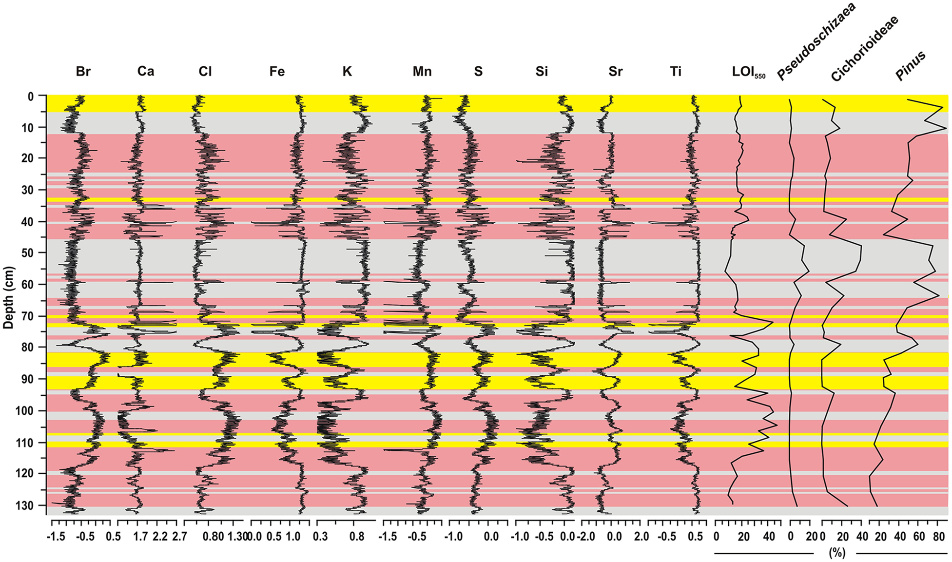
Downcore variability (center-log-ratio transformations) of selected elements derived from XRF core scanning, percentages of selected pollen taxa, and loss on ignition at 550°C (LOI550) of the Lake Vouliagmeni composite record. Red, yellow and gray bars highlight finely laminated, homogeneous, and turbidite intervals, respectively, as identified by sediment microfacies analysis.
Homogeneous sediments
This facies consists of biogenic material such as diatom frustules and amorphous organic matter, and fine-grained minerogenic material. It is characterized by continuous, stratified deposition lacking features of sediment mixing such as bioturbation or erosion/redeposition. The geochemical data show varying elemental and organic matter contents (Figure 6).
Sediment geochemistry
The LOI550 values range between 7% and 43% in the composite record from Lake Vouliagmeni (Figures 5 and 6). The interval from c. 67 to 130 cm (corresponding to 1710–1830 AD) is characterized by the highest LOI550 values in the record, and hence highest deposition and/or best preservation of organic matter in the sequence. In contrast, the uppermost interval of the sequence (0–67 cm; 1830–2015 AD) shows consistently lower LOI550 values, which is indicative of decreased deposition and/or preservation of organic matter. Moreover, turbidite layers generally show low LOI550 values and minor internal variability (Figure 6).
The PCA analysis applied to the composite XRF elemental record from Lake Vouliagmeni reveals two principal components (PC) accounting for about 92% of the total variance of the dataset. Positive correlations are found among elements with similar orientations in the biplot and reveal that the elements measured are indicative for three main sedimentary groups (Figure 7; Supplemental Figures 1 and 2). Positive correlations are found among elements that can associated with detrital sediments (Si, K, Ti, and Fe), elements that can associated with carbonates (Ca, Sr), and elements that can be associated with organic matter (Br, Mn, S) and pore fluids (Cl). This grouping differentiates the elements that typically represent detrital components in aquatic systems from elements that are related with salinity changes in lagoonal settings due to variability in freshwater input and evaporation (e.g. Croudace and Rothwell, 2015, and references therein).
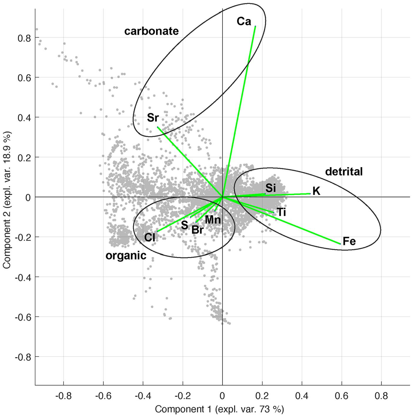
Principal Component Analysis (PCA) of the XRF-based elemental dataset from Lake Vouliagmeni. The first two components explain 91.9% of the total variance.
Palynology
The pollen data from Lake Vouliagmeni record a diverse flora consisting of arboreal and non-arboreal taxa (Figure 8). While the record is dominated by Pinus, Mediterranean sclerophylls (including Ceratonia, Cistus, Ericaceae, Juniperus, Myrtus, Phillyrea, Pistacia, and Quercus ilex type) form the second most dominant pollen group, accounting for 48.8% of total pollen on average in each sample (range: 38.6–60.3%). Pollen grains from cultivated plants (including Castanea, Juglans, Olea, and Vitis) comprise 8.7% on average (range: 1.8%–20.3%), followed by temperate deciduous trees (including Carpinus, Corylus, Ostrya, Quercus cerris/robur type, Taxus, Tilia, and Ulmus) that account for 8.6% (range: 1%–15.4 %). Riparian trees (including Alnus, Platanus, and Tamarix) and montane trees (including Abies) account for 1.2% (range: 0%–6.3%) and 1.6% (range: 0%–6.3%), respectively. The most common non-arboreal pollen taxa include Poaceae (mean: 11.9%), Plantaginaceae (mean: 3.4%), Cichorioideae (mean: 3.2%) and other types of Asteraceae (mean: 2.8%), Cyperaceae (mean: 1.6%), and Chenopodiaceae (mean: 1.3%). Moreover, pollen from aquatic plants (including Callitriche, Typha angustifolia, and T. latifolia types) are continuously present, accounting for 1.2% on average (range: 0%–3.0%). Finally, the most common algae is Pseudoschizaea, with maximum abundances of 4.6%.
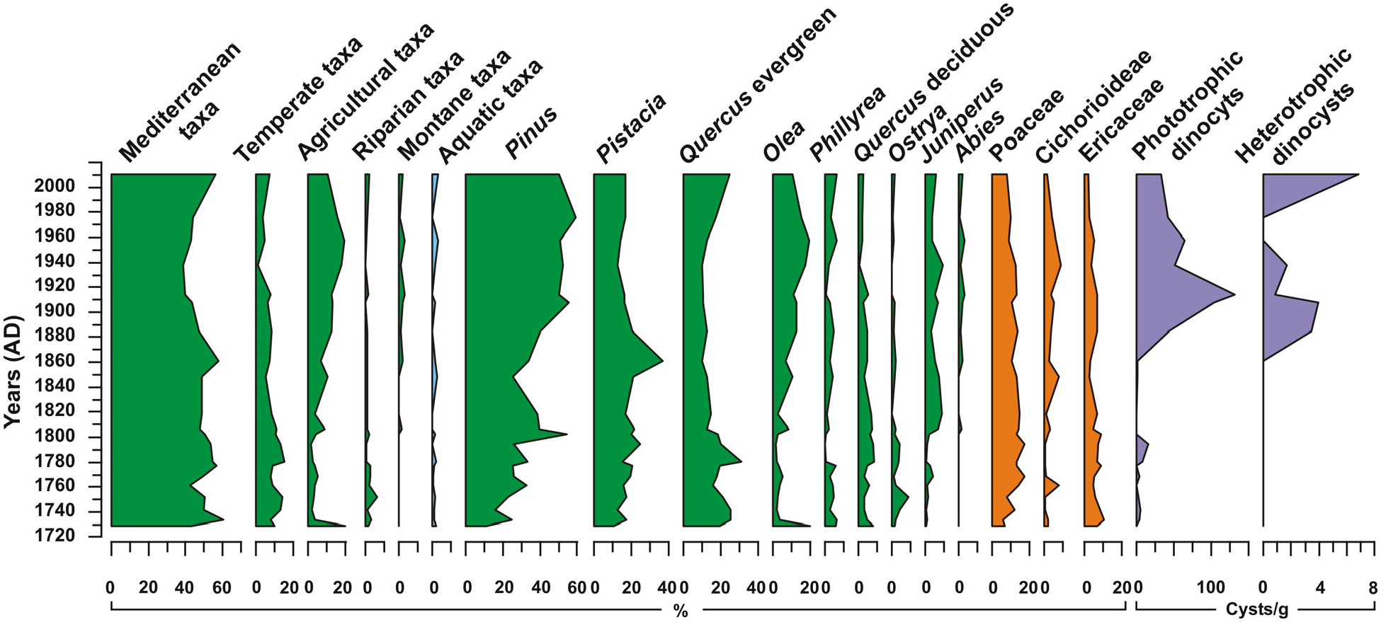
Selected pollen taxa percentages and dinoflagellate cyst concentrations from Lake Vouliagmeni between c. 1730 and 2015 AD.
Among the dinocysts in the Lake Vouliagmeni sediments, phototrophic taxa (including Lingulodinium machaerophorum, Nematosphaeropsis labyrinthus, Operculodinium sp., and Spiniferites sp.) are dominant, with mean concentrations of 24.4 cysts/g (range: 0–132.2 cysts/g) (Figure 8). Heterotrophic taxa (including Brigantedinium sp., Gymnodinium noleri/microreticulatum, Echinidinium sp., Selenopemphix quanta, and Stelladinium stellatum) are also present with mean concentrations of 0.8 cysts/g (range: 0–6.9 cysts/g). While dinocysts appear to be present throughout the record, their concentrations show a tenfold increase in the sediments from c. 1880 onward marking the onset of a permanent connection between the sea and the lake (Figure 8).
Discussion
Seasonal sedimentation processes and varve formation
The alternating couplets of light and dark layers preserved in the cores from Lake Vouliagmeni indicate that distinct sedimentation processes dominated during different seasons, thereby suggesting that the laminated sediments represent true varves. On the basis that one couplet of light and dark layers may represent one varve, the counting of the total number of couplets within the independently radionuclide dated core interval provides unequivocal proof of their annual nature. Specifically, 19 and 59 varves were deposited in the 5–17 cm and 17–31 cm composite core intervals, respectively, which is in agreement with the duration of these intervals as derived by 137Cs and 210Pb dating (Figure 3). Altogether, continuous varve deposition in Lake Vouliagmeni occurred from 1710 to 1736 AD and from 1839 to 1978 AD; in addition, another 31 varves are registered in the interval spanning from 1751 to 1825 AD, and one varve in the uppermost part of the record that has possibly been deposited in 2013 AD (Figure 5). In the following, a detailed description of the different seasonal processes controlling the formation of the two varve types in Lake Vouliagmeni is discussed.
The Lam-I type laminations represent endogenic evaporitic (aragonite) varves (Brauer, 2004; Zolitschka et al., 2015) as they are commonly found in coastal marine and lagoonal settings (Schimmelmann et al., 2016). The precipitation of aragonite is ascribed to the increased salinity in these settings resulting from high evaporation and/or reduced freshwater input as it typically occurs in arid and semi-arid environments (e.g. Brauer, 2004; Zolitschka et al., 2015) such as the Dead Sea (e.g. Ben Dor et al., 2019), but also in coastal areas of the Mediterranean region, for example, in the Butrint (Ariztegui et al., 2010; Morellón et al., 2016) and Etoliko (Koutsodendris et al., 2015, 2017) lagoons. In these lagoonal environments, the deposition of aragonite layers takes place in spring/summer when temperature and evaporation reach their maxima, and riverine input is minimal. In contrast, the dark layers consisting of amorphous organic matter, benthic microfossil remains (such as pennate diatoms, bivalves and gastropods) and increased minerogenic content are deposited during autumn/winter. Because benthic organisms cannot thrive under the oxygen-depleted conditions in the deeper water column as they prevail in Lake Vouliagmeni likely throughout the year (Vardala-Theodorou and Nicolaidou, 2007), lenses of benthic organisms in the dark layers indicates reworked sediment that was mobilized from the oxygenated littoral zone under stormy conditions as they frequently occur at the study site during autumn and winter. The increased organic and minerogenic contents are attributed to the surface runoff and riverine input into Lake Vouliagmeni, which reach maximum levels between November and March (Hellenic National Meteorological Service, 2016). Further support for this scenario is provided by the regular presence of mm-thick detrital laminae within the dark layers, which can be assigned to discrete rainfall events (e.g. Corella et al., 2014; Czymzik et al., 2010; Mangili et al., 2005). Differences in the composition of the Lam-I varves during specific time intervals in our record, such as absence of distinct mm-thick aragonite or organic-rich layers and dominance of fine-grained minerogenic material (see Section “Finely laminated facies”), document transient changes in the prevailing climate regime that affected the environmental conditions in the lake and its catchment area. Because in the similar lagoonal settings of Butrint and Etoliko the deposition of aragonite is associated with increased salinity (Ariztegui et al., 2010; Koutsodendris et al., 2015), its absence across certain intervals of the Vouliagmeni record may result from somewhat lower salinity related to increased spring/summer precipitation and/or decreased evaporation due to lower temperatures. The lack of organic-rich layers can be attributed to decreased biogenic productivity possibly associated with reduced nutrient availability in the lake.
The Lam-II type laminations represent mixed clastic-biogenic varves (Zolitschka et al., 2015) associated with enhanced lacustrine productivity, low terrestrial runoff in spring/summer and high terrestrial runoff in autumn/winter. The composition of the light layers (i.e. predominately centric diatom frustules and other algal remains) indicates high biogenic productivity during the time of deposition. The dominance of Thalassiosira sp. among the diatom remains suggests that the organic-diatomaceous layers were deposited during spring/summer, as this genus typically thrives between April and July in Greek coastal waters (Nikolaides and Moustaka-Gouni, 1990). Further support for such a seasonal signal comes from the deposition of merely fine-grained minerogenic material, which testifies to relatively dry conditions and minimum terrestrial runoff as it is typical for the summer months. In contrast, the minerogenic-rich dark layers with larger grain sizes can be attributed to runoff-related detrital influx into Lake Vouliagmeni during the wet autumn/winter periods. Further evidence for deposition during autumn/winter comes from the presence of lenses containing benthic organisms (e.g. bivalves, gastropods) within the minerogenic layers that indicate reworking of sediments from the littoral zone during storm-weather conditions as they typically occur during that part of the year.
Based on the sedimentological characteristics of both varve types, the variability in terrestrial runoff between the wet autumn/winter and dry spring/summer seasons is the main natural driving factor for varve formation at Lake Vouliagmeni, with other factors such as productivity playing only a secondary role. In the formation of the endogenic varve type (Lam-I), the terrestrial runoff affects the salinity levels, and in turn, the deposition of aragonite that typically occurs under increased salinity in regional lagoonal settings; in the formation of the mixed clastic-biogenic varves type (Lam-II), the terrestrial runoff is responsible for the distinctive seasonal differences in grain size. Supporting evidence for the pivotal role of terrestrial runoff in varve formation is provided by the XRF data. Specifically, the varved intervals in the Lake Vouliagmeni sequence predominantly coincide with high contents of terrigenous elements such as Si (Figure 5), in contrast to the homogeneous lake sediments (e.g. at c. 1735–1760 AD, c. 1770–1810 AD, and c. 1980–1990 AD) that are characterized by low Si and hence relatively low terrigenous input.
Lacustrine turbidites
The available microfacies and palynological data suggest that the coarsely laminated and partly graded facies represents turbiditic deposits. Specifically, their sharp lower boundaries and fining-upward grading indicate instantaneous deposition of detrital material related to density (or “turbidity”) currents (e.g. Corella et al., 2014; Czymzik et al., 2010; Mangili et al., 2005). The lack of erosional structures in the microfacies analysis together with the distinctly different thicknesses of this facies in the five cores retrieved from Lake Vouliagmeni (Figure 2) suggest that the source material originated from the littoral zone and was deposited locally following downslope transport, resuspension in the water column, and settling at the lake’s depocenter. The palynological data provide additional evidence that the origin of the detrital material is the shallow littoral zone and that the turbiditic deposits are related to sub-aquatic flows. Specifically, the littoral zone comprises the main depositional environment in lakes for Pinus and Cichorioideae pollen types (e.g. Behre, 1990; Bottema, 1975; Faegri and Iversen, 1989; Traverse, 2007) and Pseudoschizaea algal remains (e.g. Carrión, 2002) as is the case for the turbidite intervals in Lake Vouliagmeni (Figure 6).
In the 131 -cm-long composite record, a total of 23 detrital layers corresponding to 14 lacustrine turbidites with a total thickness of c. 47 cm have been documented. Because of the extreme seismic activity in the eastern Gulf of Corinth region (Ambraseys and Jackson, 1990, 1997; Makropoulos et al., 2012), we assume that the slope instabilities in Lake Vouliagmeni may have been triggered by seismic shocks (e.g. Knapp et al., 2018; Moernaut et al., 2014; Schnellmann et al., 2002). Considering the age-model uncertainties for the homogeneous intervals, comparison of the timing of turbidite deposition in Lake Vouliagmeni with instrumentally recorded and historical earthquakes in the Gulf of Corinth region (Ambraseys and Jackson, 1990, 1997; Makropoulos et al., 2012; Tsapanos et al., 2011) suggests that 12 out of the 14 lacustrine turbidites may indeed have been triggered by earthquakes (Table 1). Most notably, the uppermost turbidite that was deposited in 1981 AD based on our age model (Table 1) coincides with a series of catastrophic earthquakes between February and December of 1981 with magnitudes of up to 6.7 and epicenters located 10–30 km east of Lake Vouliagmeni (Collier et al., 1998; Papazachos et al., 1984). Another prominent turbidite layer in the Lake Vouliagmeni record is that deposited during 1860 AD (Table 1). Based on the historical seismological record, it may have resulted from a strong earthquake in 1858 AD that destroyed the town of Korinthos c. 10 km to the southeast of the lake (Ambraseys and Jackson, 1997; Tsapanos et al., 2011).
Our turbidite record from Lake Vouliagmeni also documents two layers at about 1711 and 1825 AD that have no counterparts in the record of strong historical earthquakes. Despite that several documented earthquakes could have potentially been responsible for these turbidites (Table 1), the age-model uncertainties do not allow any unequivocal correlations. Alternatively, these two turbidite layers may be connected to relatively weak, smaller-scale earthquakes associated with movements along the local faults close to the lake (Duffy et al., 2015; Maroukian et al., 2008) that have not been reported in historical documents. Other potential trigger mechanisms for the sediment mass-movements include increased terrestrial runoff or floods. While such local climatic events have been repeatedly registered across Greece during the past three centuries (e.g. Xoplaki et al., 2001), the absence of any historical documentation from the Vouliagmeni region makes the assignment of these turbidites to a climatic trigger unlikely. Another potential trigger mechanism could be via sea-water incursions either during extreme storms or tsunamis given that the Gulf of Corinth represents one of the most tsunamogenic regions in Greece (e.g. Stefatos et al., 2006) and several tsunamis have been reported for the area in historical times (Papadopoulos, 2003). Evidence for occasional connections between the lake and the sea prior to the establishment of the artificial channel at c. 1880 AD is provided by the sporadic presence of marine diatoms (Figure 5) and dinoflagellate cysts (Figure 8). However, in the absence of direct, independent documentation of tsunamis and storm-induced overwash of marine waters into Lake Vouliagmeni, and considering the potential for the deposition of marine microplankton in the lake sediments via wind-blown seawater, the role of seawater incursions in turbidite formation at Lake Vouliagmeni remains elusive.
Whereas the identified 23 turbiditic layers comprise about 36% of the length of our 131 -cm-long composite record, their proportion is markedly different in the individual cores, reaching about 70% in LVL15-5 (compare Figure 2). While this clearly demonstrates that large differences in the thickness of the turbiditic layers can occur within a small area in the deepest part of the lake, it appears difficult to reconcile these numbers with a total turbidite thickness of merely 52 cm (i.e. 9% of the total core length) as reported in a previous 6 -m-long core from Lake Vouliagmeni (Emmanouilidis et al., 2020). We attribute the difference in the abundance and thickness of turbidite layers between the two records to derive from the applied sedimentological techniques, which include the integration of continuous microfacies analysis and XRF data in our study, and the absence of ground truthing of the analytical signals derived by computer tomography and XRF data via microfacies analysis across the entire long core from Lake Vouliagmeni. Together, our results highlight the significance of examining multiple cores and applying continuous microfacies analysis on records from tectonically active settings such as Lake Vouliagmeni. This approach warrants the identification of turbiditic deposits and their discrimination from the non-laminated, homogeneous sediment facies, and, as such, allows to minimize the potential for misinterpretations of the sedimentological signals.
The Lake Vouliagmeni record within climatic and historical contexts since 1700 AD
The partially varved record from Lake Vouliagmeni represents the first archive from the Balkan Peninsula east of the Pindos Range that can provide insight into the environmental and climatic variability for much of the past 300 years at an annual resolution. It spans the youngest part of the Little Ice Age and the entire Industrial Period, which are marked by considerable climate- (e.g. Büntgen et al., 2016; Luterbacher et al., 2012; PAGES 2k Consortium, 2013) and human-induced ecosystem changes (e.g. Jenny et al., 2016; Lotze et al., 2006).
From a climatic perspective, our data suggest that the oldest part of our record from c. 1710 to 1735 AD is characterized by varve deposition associated with increased terrigenous input (e.g. high Si content) that represent relatively wet conditions at Lake Vouliagmeni. This period, which extends beyond the end of the solar Maunder Minimum (1645–1715 AD), has also been characterized by relatively wet conditions at Butrint and Etoliko lagoons (Figure 1), where increased clastic input has been attributed to high precipitation (Koutsodendris et al., 2017; Morellón et al., 2016). Varve formation at Lake Vouliagmeni was interrupted for about a century between c. 1735 and 1840 AD, a period that coincides with the solar Dalton Minimum (1790–1830 AD). The corresponding core interval contains only 15 evaporitic varve couples, and the remainder of the core interval consists of homogeneous sediments with generally low Si content (Figure 5). These sedimentological characteristics are indicative of reduced terrestrial input and high salinity, which in combination with increasing pollen percentages of the dry tolerant Pinus and decreasing pollen percentages of riparian trees and aquatic plants (Figure 8) demonstrate the prevalence of relatively dry conditions at Lake Vouliagmeni. Notably, the solar Dalton Minimum was also characterized by relatively dry conditions at Butrint and Etoliko lagoons (Koutsodendris et al., 2017; Morellón et al., 2016). Hence, our data confirm the regionally dry conditions during the Dalton Minimum and allow to refine previous findings from lower-resolution records that pointed to wet conditions at Lake Vouliagmeni throughout the Little Ice Age (Emmanouilidis et al., 2022). In summary, the consistent hydroclimate signals between c. 1710 and 1840 AD at Butrint, Etoliko and Vouliagmeni demonstrate that similar climatic conditions prevailed across the entire southern Balkan Peninsula during the younger half of the Little Ice Age. Our data support the view of temporal hydroclimate heterogeneity during the Little Ice Age (e.g. Ljungqvist et al., 2016), which has been suggested to originate from atmospheric circulation variability in the Northern Hemisphere (Hu et al., 2022; Luterbacher et al., 1999; Ortega et al., 2015).
At Lake Vouliagmeni, the c. 140-year-long period from c. 1840 to 1980 AD is characterized by uninterrupted varve formation. Whereas endogenic varves were deposited during this interval, mixed clastic-biogenic varves formed during the subsequent interval from 1940 to 1980 AD. Generally, the 1840–1865 AD, 1940–1980 AD, and 1895–1900 AD intervals are characterized by somewhat reduced terrestrial input as indicated by the low Si content; in contrast, the intervals from 1865 to 1895 AD and from 1900 to 1940 AD are associated with increased terrestrial input based on the relatively high Si content (Figure 5). Although the different sedimentation regimes and varve types may also have resulted from a hydroclimate change toward drier conditions, we posit that the contrasting signals originate from human activities altering the vegetation and ultimately the sedimentation processes in the catchment area of the lake. Specifically, our palynological data document the expansion of agriculture from the 1820s onward peaking during the 1940s to 1980s (Figures 5 and 8); the intensification of land-use changes probably led to enhanced soil erosion in the catchment area causing an increase in clastic input into the lake. The onset of a permanent connection to the sea at around 1880 AD due to the excavation of an artificial channel allowed marine-based nutrients to enter the lake on top of the nutrient input from the catchment area. Together, these processes enhanced the primary productivity in the lake and hence amplified the seasonal contrast in sedimentation processes (i.e. increased clastic input in autumn/winter vs increased productivity in spring/summer). As a consequence, the boundary conditions required for varve formation were maintained even during dry years.
Altogether, the nutrient-rich environment resulting from human activity in concert with the considerable depth of the lake basin appears to have been responsible for the continuous varve deposition at Lake Vouliagmeni from about 1840 to 1980 AD under the different hydroclimate regimes that the region experienced during that time (Katsoulis and Kambetzidis, 1989). The human-induced nutrient input into the lake may also have been responsible for the cessation of varve formation from the 1980s onward. Specifically, the two- to threefold increase in heterotrophic dinoflagellate cyst taxa in the recent decades provides evidence for eutrophicated conditions (e.g. Dale, 2001; Pross and Brinkhuis, 2005) due to the expansion of agricultural measures around freshwater ecosystems in Greece from the 1980s onward (Zalidis et al., 1997). A similar eutrophication signal has also been documented for Etoliko lagoon where the seasonal sedimentation regime and varve formation changed drastically with the expansion of agriculture during that time (Koutsodendris et al., 2015). In contrast to Etoliko lagoon, where high sedimentation rates throughout the year helped maintain the formation of distinctive varve sub-layers, the expansion of eutrophication throughout all seasons in Lake Vouliagmeni since the 1980s appears to have overwritten the clastic input signal responsible for the formation of the autumn/winter sub-layers during an exceptionally dry period in Greece that lasted from 1978 until 1997 (Dimitrakopoulos et al., 2011).
Our interpretation of the human-induced environmental change at Lake Vouliagmeni gains further support from historical documentation. In 1715 AD the region passed from Venetian occupation to Ottoman control (Kiel, 2016). The Ottoman rule was maintained until the late 1820s followed by the turbulent period of the Greek Revolution that led to establishment of the Greek state in 1827 AD. Under the Ottoman rule, the socioeconomic role of Korinthos city (Figure 1) was weakened considerably: While the city was the second largest in the region in 1716 AD, it only ranked fourth in 1790 AD (Kiel, 2016). Travelers visiting the area such as Pococke in 1736 AD, Dodwell in1801–1806 AD, and Turner in 1813 AD describe the town as very small, thinly populated with scattered houses, and the greater area of the Isthmus of Korinthos being uncultivated and covered by shrubs and few small firs (Gregory, 2007; Shariat-Panahi, 2015). Our pollen data from Lake Vouliagmeni provide support for this historical development. They yield the lowest percentages of cultivated plants (particularly of Olea) and an increase in the percentages of forest taxa (including Pinus, evergreen and deciduous Quercus, and Carpinus/Ostrya) during the period of Ottoman rule (Figure 8). This testifies to the abandonment of agricultural activities and the recovery of natural ecosystems during that time. The subsequent establishment of the Greek state in the region was marked by a rapid population recovery and the expansion of agriculture (Kiel, 2016). This historical documentation is again in close agreement with our pollen data that portray an increase in the percentages of cultivated plants (Figure 8). Moreover, our pollen data indicate increased percentages of forest elements that dominate at higher elevations of the Geraneia mountains (such as Abies and Juniperus); this reforestation temporally correlates with the establishment of the Greek State and persisted throughout the 20th century (Figure 8). This is explained to reflect the expansion of human land-use changes (such as urbanization and industrialization) at low- and mid-elevation altitudes resulting in lower forest cover and, in turn, reduced pollen flux from tree taxa that typically grow at these elevations (such as deciduous Quercus and Pistacia).
Conclusions
Our multiproxy record from Lake Vouliagmeni provides insight into the climatic and human impacts on terrestrial ecosystems in SE Europe since c. 1700 AD. The uninterrupted varve period between c. 1840 and 1980 AD and the partially varved record from 1710 to 1840 AD, indicate considerable hydroclimatic variability over the past 300 years and notably during the Little Ice Age. Whereas our data suggest that the varve formation was naturally controlled via contrasting terrestrial input from the catchment area between the wet autumn/winter and dry spring/summer periods from c. 1710 to 1940 AD, the role of human-induced primary productivity in the lake during spring/summer became prominent from the 1940s onward. Moreover, our pollen data indicate regional vegetation change (i.e. in agriculture and extent in natural forest) that are in agreement with historical documentation on regional population size and land use over the past 300 years. In addition, the sedimentological and geochemical data testify to the regular deposition of turbidites in Lake Vouliagmeni, with many of them likely having been triggered by earthquakes in the Gulf of Corinth region. Overall, our results highlight the potential of Lake Vouliagmeni for unraveling naturally and human-induced environmental changes during the Holocene.
Supplemental Material
sj-docx-1-hol-10.1177_09596836231183062 – Supplemental material for Natural and human-induced ecosystem change in SE Europe since AD 1700 derived from a partially varved sediment record from Lake Vouliagmeni (Greece)
Supplemental material, sj-docx-1-hol-10.1177_09596836231183062 for Natural and human-induced ecosystem change in SE Europe since AD 1700 derived from a partially varved sediment record from Lake Vouliagmeni (Greece) by Andreas Koutsodendris, Achim Brauer, Oliver Friedrich, Rik Tjallingii, Victoria Putyrskaya, Barbara Hennrich, Robert Kühn, Eckehard Klemt and Jörg Pross in The Holocene
Footnotes
Acknowledgements
We thank Brian Brademann and Tobias Fischer for their assistance during the coring campaign, and Ilse Glass, Michael Köhler, Laurin Kolb, and Alexander Varychev for technical support. Steve Bohaty is thanked for diatom identification. All data will be archived in the Pangaea database (![]() ) upon publication.
) upon publication.
Funding
The author(s) received no financial support for the research, authorship, and/or publication of this article.
Supplemental material
Supplemental material for this article is available online.
References
Supplementary Material
Please find the following supplemental material available below.
For Open Access articles published under a Creative Commons License, all supplemental material carries the same license as the article it is associated with.
For non-Open Access articles published, all supplemental material carries a non-exclusive license, and permission requests for re-use of supplemental material or any part of supplemental material shall be sent directly to the copyright owner as specified in the copyright notice associated with the article.