
Abstract
This article explores the landscape dynamics at the island of Barbuda in the context of changing climate to understand (1) the environmental setting of indigenous settlements; (2) the impacts of current coastal processes; and (3) the potential threats moving forward toward increasing pressure of climate change. Focusing on the site of Seaview, on the east coast of Barbuda, we use geoarchaeological methods to reconstruct the ancient geomorphological setting, investigate changes post-abandonment, and identify the hazards faced under future sea-level projections. Our study shows that (1) sea level stabilization after the Mid-Holocene allowed the formation of coral reefs, seagrass beds and other benthic ecosystems that allowed for biogenic sediment accumulation and growth of sand dune retention ridges. (2) These environmental characteristics, including rich marine food sources, supported the establishment and flourishing of Seaview starting ca. 160 BC. (3) Occupation ended at some point between AD960 and 1000. This change coincided with a period of increased storminess, higher SSTs, and possible coral reef mortality that affected both food availability and sediment supply. (4) Lack of sediments triggered progressive sand dune erosion that continues today and has left the sand dune ridge past the tipping point of erosion. (5) Looking into a future of rapidly changing climate, sea level rise poses a severe and devastating threat to the land- and seascapes of Barbuda. With the lowland coastal plain at or only slightly above current sea level, a rate of SLR comparable to Mid-Holocene rates, and rapid loss of sand dune ridges and coral reefs as natural barriers, it is just a matter of time before the lowlands become transformed beyond recognition. The results of this analysis can be used to improve long-term management of the heritage resources of Barbudans and shed light on parallel challenges experienced on other tropical coastal locations.
Keywords
Introduction
Sea level rise and its associated process, coastal erosion, pose threats to coastlines around the world. The nuances of these hazards are particular to different locations, as the details of wave incidence, sediment budgets, coastal geomorphology, nearshore ecosystems, offshore characteristics, and rates of storminess and storm surge impacts intertwine to modulate the specific effects of climate change over specific sections of coasts (Rivera-Collazo et al., 2021). Understanding these processes can shed light on the risks that local communities and heritage managers are facing, as well as the longer-term impacts that human activity is having over the coasts. This is particularly urgent for tropical oceanic islands, where accelerated climate change and disaster capitalism are pressing social vulnerability and threatening the continuity of islander identities (d'Alpoim Guedes et al., 2021; Perdikaris et al., 2021).
While hazards are concrete instances of exposure to physical damage, risks are socially perceived and constructed (Adger, 2006; Adomah Bempah and Olav Øyhus, 2017; Nelson et al., 2007; Thomas et al., 2019). A situation is considered risky if the hazard threatens the continuation of specific components of social structures and cultural identity. Adaptation to change, therefore, occurs only when the hazard is perceived as a risk. Otherwise, there will be no change in behavior because the hazard will be considered tolerable (Adger et al., 2009; Vedwan, 2006). Exploring deep-time landscape and human dynamics from the perspective of archeology helps to contextualize risk by identifying how conditions have changed through time and what measures cultures take to mitigate hazards. By investigating these processes, it might be possible to pinpoint which components of social structure and identity are prioritized at different times, allowing for a more nuanced understanding of resilience (Rivera-Collazo, 2022).
Shelter and food security are elements of social structures that can be directly linked to climate-related hazards (Rivera-Collazo, 2021, 2022). Shelter security focuses on the specific locations on the landscape where communities are placed, and how these settings might expose individuals to negative impacts from flooding, drought, landslides, storms, and other physical hazards. Food security focuses on the ability to supply culturally relevant food items and support traditional subsistence practices. The availability of these items within territories could be threatened if changes in climate causes flooding, aridity, changes in atmospheric or marine temperature, and other conditions that could affect the distribution of ecosystems and the biodiversity within traditional subsistence-related territories.
Understanding how local, native and descendent communities live on coastal zones, and what are their traditional responses to climate change, can contribute to the development of culturally-sensitive policy (Douglass and Cooper, 2020; Kohler and Rockman, 2020; Rivera-Collazo, 2021; Rockman, 2012; Rockman and Hritz, 2020). Community-based, participatory, and engaged archeological research, such of that by Dawson in Scotland (Dawson, 2013), Douglass in Madagascar (Douglass et al., 2019; Stephens et al., 2019), Armstrong in the Pacific Northwest (Armstrong et al., 2021), Perdikaris in Barbuda (Boger et al., 2019; Burn et al., 2022), and Rivera-Collazo in Puerto Rico (Rivera-Collazo et al., 2020, 2021) demonstrate the importance of designing and implementing transdisciplinary approaches that not only look at multiple scales through time, but that fully incorporate local and descendant communities.
Even though the number of archeological research on climate change has increased in recent years, the work is only slowly making impacts on policy because there is a huge amount of policy to influence and few archeologists meaningfully contributing work that is readily translatable into useful lessons for the present (d'Alpoim Guedes et al., 2021; Kohler and Rockman, 2020). Also, the fact that there is more research does not mean that there is more understanding. Many publications often stop at describing examples and stating that archeology can contribute to the conversation, but not produce useful evidence of how specifically the past links to the present problems (e.g. (Liritzis et al., 2019; Zhen, 2021)). There is still a huge gap between making this claim and presenting concrete and useful examples. Rivera-Collazo (Rivera-Collazo, 2022) argues that useful analysis of the past for the present must be mindful of chronology and timing of events in archeological and environmental data; downscale climate data and pay attention to microlocal effects in high-resolution; generate multi-proxy data avoiding single-variable reporting; engage with up-to-date high resolution social theory on social vulnerability; specify threats, magnitude, and predictability of the impact in the context of traditional knowledge; and look at change before, during and after impact. There is also a gap between traditional western knowledge production favoring straightforward variable measurement and indigenous-inspired approaches that remind us of the importance of local and traditional knowledge. Archeological projects incorporating the public have demonstrated the importance of meaningful community engagement for climate action (Dawson et al., 2021; Miller and Murray, 2018).
Focusing on marine settings in the Caribbean Region; rapid sea level rise, increased storminess, and higher sea and atmospheric temperatures are hazards already causing impacts and forecasted to increase in the future. They also have the potential to impact food and shelter security. In this article, we look into the past, at times when these hazards have occurred and impacted Caribbean people and look at what effects were registered in the societies and the physical landscapes. We then use this background to consider what can be expected for future changes in climate from the perspective of Caribbean identities. We specifically focus on the Caribbean Island of Barbuda as a case study to understand how a deep-time perspective of landscape and human ecodynamics can contribute to the identification of risks and hazards for island societies in the present and future.
Human presence in Barbuda
Politically, Barbuda is part of the Antigua and Barbuda nation. Coastal erosion has been observed in these islands for many years. In Antigua specifically, where many historic forts dot the coastline, marking the lines of defense of the 18th Century British Empire, the impact of the coastal retreat is impressive. First-hand observation of these changes includes historic structures now beneath the water surface, wave cut notches, washing away the sediments supporting the foundations of historic buildings, changed currents, eroding roads and archeological deposits, and recent modifications to historic port complexes to curtail the impact of high-tide flooding and maintain access to buildings (Finneran, 2017; Wells et al., 2018, 2019). In Barbuda, however, the markers of human presence on the coastline are less evident. Recent coastal erosion and geomorphological reshaping are evident in the transgression and regression of the sandy beaches, the breaching of the Codrington lagoon, and the collapse of rocky cliffs.
Over the last 50 years, Barbuda has been extensively surveyed and excavated by several teams from a variety of institutions. Paleontological surveys by the Florida Museum of Natural History (FLMNH) in the 1960s (Auffenberg, 1958; Etheridge, 1964; Lynch, 1966) identified the rich potential of the island to inform about Caribbean paleofauna. David Watters of the Carnegie Museum of Natural History (Watters, 1980) did extensive archeological surveys and small-scale excavations (Watters 2001; Watters et al., 1992), and also carried out the first zooarchaeological analyses for the island (Steadman et al., 1984). Watters identified 26 archeological sites, primarily on the eastern part of the island near the Highlands (Watters, 1980; Watters et al., 1984). The preponderance of the sites belongs to the Ceramic Age – Saladoid-series pottery, and a few from the Late Ceramic Age sites with post Saladoid-Troumassoid series pottery. Research since 2005 directed by Sophia Perdikaris (CUNY/UNL) as part of the Barbuda Historical Ecology Project (Hambrecht and Look, 2009; Hambrecht et al., 2011; Perdikaris et al., 2008, 2009, 2010, 2013, 2017, 2018), and collaborations with Université Laval, Canada (Bain et al., 2018; Faucher, 2018; Faucher et al., 2016, 2017; Ladouceur and Bain, 2019; Noël et al., 2016; Rousseau, 2014; Rousseau et al., 2017) as well as the Muséum National d’Histoire Naturelle in Paris (Grouard et al., 2012, 2013; Jallon and Grouard, 2019) have also unearthed extensive occupations and village settings conducting rescue excavations at the site of Seaview near Two Foot Bay, and Indian Town Trail. They further identified an additional 10 Archaic sites, 42 Saladoid sites, 5 post Saladoid sites, 14 historic sites, 18 historic well complexes, and a plantation site (Figure 1). All together, these individual investigations demonstrate that Barbuda has been continuously occupied for 4000 years, from the Archaic to the present.
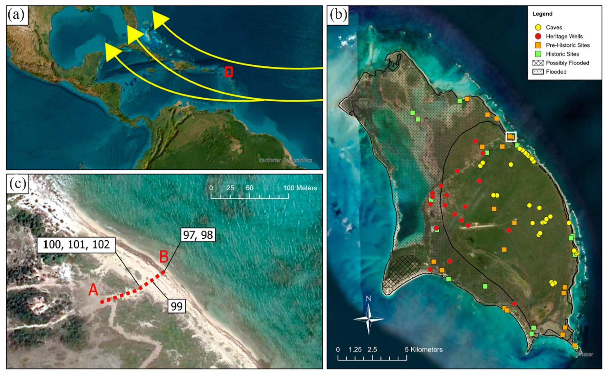
Research context for this study. (a) Location of Barbuda (red square) in the Caribbean Sea and within the Hurricane Alley (arrows). The Hurricane Alley is the area band from the Atlantic coast of Africa to the Gulf of Mexico where tropical storms form and travel in. (b) Close up to Barbuda showing the location of sites of archeological importance including caves, wells, prehistoric and historic sites. This view also marks in the areas that were flooded and possibly flooded during and after the impact of Hurricane Irma. (c) Close up to Seaview and Two Foot Bay. Line A-B marks the transect and the sampling locations for this study. The light-colored sediments are the biogenic sand at the beach and sand dunes. The dark color around the letter A is the partially-buried cultural layer of Seaview. Map Courtesy of Eric Rodríguez-Delgado, Human Ecology Lab, UC San Diego.
Unlike many Caribbean islands, including Antigua, the landscape of Barbuda was not transformed by sugar plantations nor destroyed by construction associated with modern tourist venues. Archeological sites had largely survived the passage of time up until 2017. Climate change impacts and recent intense construction and privatization activities post 2017 Hurricane Irma, have already destroyed numerous sites of both tangible and intangible cultural heritage, and continue their destructive unrelenting path (Boger and Perdikaris, 2019; Boger et al., 2019). These characteristics – 4000 years of continuous human habitation, exposed locations sensitive to climate variability, and the need to produce locally relevant forecasts of landscape change – make Barbuda an ideal setting for our analysis.
Geomorphological and cultural setting
Barbuda is a 161 km2 flat limestone island at the edge of the Caribbean continental plate, in between the Atlantic Ocean and the Caribbean Sea. The location of the island on the plate is relevant, not so much as a seismic hazard but because the east side of the island has leading edge coastlines, while the west side has trailing edge characteristics. Thus, Barbuda presents a complexity of coastal morphologies, from oceanic coastlines with sand dunes and cliffs facing the Atlantic Ocean, to low-energy lagoons, sandy low energy beaches, and wetlands supporting mangrove and salt marsh ecosystems facing the Caribbean Sea (Watters, 1980). The eastern side of the island, toward the Atlantic, drops sharply to the trench that marks the Caribbean plate, leaving only a narrow insular shelf. The Highlands, situated along the east coast and in the central part of the island, are a ca. 40m high karstic limestone formation that includes several caves that have provided some of the richest Pleistocene and Holocene fossil faunas of the Lesser Antilles (Pregill et al., 1994), along with a number of archeological sites (Perdikaris et al., 2013). The western side, toward the Caribbean Sea, has much gentler slope, presenting a wide and shallow insular shelf, including the shallow Codrington Lagoon (Johnson et al., 2020).
Barbuda is within what is considered the hurricane alley (see Figure 1), which is the zone of warm sea surface temperature that extends from Eastern Atlantic to the Gulf of Mexico, and which fuels hurricane-level storm formation and intensity (Chiodi and Harrison, 2008). Today, the hurricane season spans from June to November every year. Barbuda’s climate is regulated by an interplay between thermodynamic processes of Sea Surface Temperature (SST) and regional wind shear which vary in response to the interannual migration of the Intertropical Convergence Zone (ITCZ), the North Atlantic High (NAH), and the Caribbean Low-Level Jet (CLLJ) (Burn et al., 2022; Cook and Vizy, 2010; Moron et al., 2016; Wang, 2007). Rainfall is strongly influenced by the Atlantic summer SSTs and the passage of African Easterly Waves and tropical cyclones. At longer time-frames, these variables are also influenced by the Atlantic Multidecadal Oscillation (AMO) and the North Atlantic Oscillation (NAO). The complex interplay of these variables through time affects rainfall and storminess in the Eastern Caribbean, not simply the latitudinal migration of the ITCZ (Burn et al., 2022). Paleoclimate studies have shown that sea level rise, SSTs and storm intensity and frequency have varied through time affecting Barbuda specifically (Brasier and Donahue, 1985; Khan et al., 2017; Knowles, 2008).
The barrier coral reefs that surround the island sustain rich marine ecosystems and mitigate the impact of waves. While coral reefs are observed around the island, the coverage of living reefs is shockingly low (Johnson et al., 2020; Ruttenberg et al., 2018). Despite widespread mortality of coral reefs, Barbuda’s marine ecosystems are rich in biodiversity. The island is well known as a source of marine protein for human consumption. However, recent studies have demonstrated relatively low fish abundance and biomass compared with other locations in the Caribbean (Johnson et al., 2020; Ruttenberg et al., 2018). Biomass was found to be relatively lower on the east coast in contrast to the north, west and south of the island.
The prehistoric archeological site of Seaview (BA016) is located on the eastern coast of Barbuda bordering the Atlantic Ocean (see Figure 1). Geomorphologically, from west to east, Seaview presents a flat coastal plain of exposed limestone bedrock with silty or loamy soil patches, a coastal retention dune ridge parallel to the shore, and a sandy beach ending at the waterline of an internal lagoon bordered by a barrier reef (Figure 2). Seaview has been excavated by the team of the Barbuda Historical Ecology Project in January 2008, 2009, 2011, and 2012. Zooarchaeological material including, animal bone, crab, and shell, as well as artifacts that are associated with typical Saladoid period ceramics have been reported on the surface and in situ. Fresh water sources were identified in close walking distance as a result of survey work conducted in August 2007. The exposed, truncated, dark brown, loamy, and artifact-rich cultural layer of the site of Seaview can be observed seaward, near the top of the sand dune ridge. This layer can also be observed as patches exposed under aeolian sand blowouts of the deflated backdune and coastal plain. Four human burials were recovered in situ, two of which had associated dog burials, with dates ranging from ca.AD 450 to 650. The more extensive settlement areas behind the dune system range from ca.BC 160 to AD 960 (Bain et al., 2018; Benoît and Manigault, 2010; Faucher, 2018; Grouard et al., 2013; Kendall et al., 2011; Perdikaris et al., 2010, 2017).
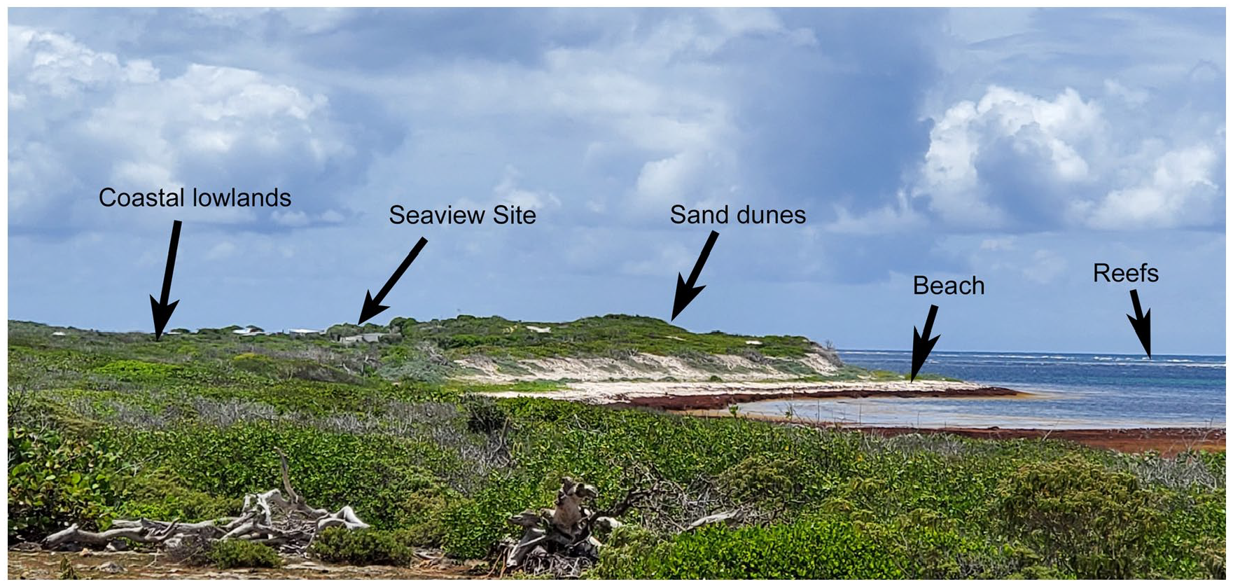
Geomorphological setting of Seaview (looking North) showing the coastal lowlands, sand dunes and the beach facing the Atlantic Ocean to the East.
Methods
To understand the ancient geomorphological setting and the changes post abandonment at Seaview, we sampled sediments along an east-west transect from the shoreline to the leeward side of the sand dune where the cultural layer of Seaview is exposed. We collected samples from the eroding water line, the storm terrace, the base of the eroding sand dune, the sand underneath the cultural layer, the cultural layer itself, the top of the sand dune, and the backdune (see Figures 1c and 3). Samples consist of 1 L volume of surface deposit or exposed profile strata along the transect. All samples and observations were registered using an EMLID RTK unit used as stand-alone rover mode, to collect high resolution (<±20 cm) XYZ data points, calibrating the unit at sea level prior to beginning measurements. Sea level was measured placing the unit on shoreline at beginning (east side) of the transect in between low and high-tide and using that measure as 0 to correct all other elevations. Measuring the real sea level reduced compounding errors. This allowed us to construct a detailed profile of the shape of the dune ridge and to topographically identify the exposed cultural layer, which upper and lower boundaries are easily recognizable on the eroded dune profile (Figure 3).
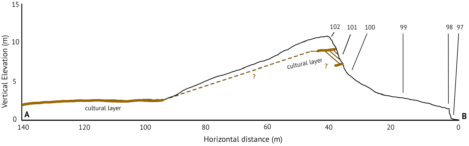
Topographic profile of Seaview and the sand dunes, starting on 0 at the shoreline (East). Line A-B corresponds to the transect marked in Figure 1c. The location of the cultural layer identified as solid lines is based on direct observations. The dotted lines represent the approximate depth of the continuation of the cultural layer beneath the loose sand of the backdune as observed on the field. This depth was not measured directly to avoid disturbing the dune. Numbers 97–102 mark the location of the samples analyzed for this study.
The samples were transported to the Human Ecology Laboratory at Scripps Institution of Oceanography for sedimentological analysis, including grain size distribution, composition and shape, organic content, pH and phosphate. Field assessment of the samples suggested mostly coarse grain composition of the samples. This was corroborated with a Laser Particle Analyzer that revealed all samples to contain insignificant amounts of particles smaller than silt. Therefore, grain size distribution was conducted using only dry sieving at standard 4, 2, 1, 0.5, 0.25, 0.125, and 0.063 mm. The coarse fraction was retained and observed under an optical dissecting microscope (Leica EZ4) to characterize composition, grain shape, grain surface characteristics and microartefact content (Jerardino, 1995; Lopez, 2017; Rosen, 1986). Organic content was determined using the standard Loss on Ignition protocol, where the percentage of organic material in a sample is measured as the weight difference after firing a sample at 550°C for 1.5 h (French, 2015; Goldberg and Macphail, 2006). The chemical characteristics of the sample were measured as pH and phosphate content. Determination of acidity (pH) level was calculated using a pH meter. The samples were suspended in DI water and allowed to stabilize in solution for 5 min before measuring (French, 2015). Phosphate content was assessed using the Gundlach method where presence of phosphorus is determined in a relative scale of 0–5, where 0 is no reaction and 5 is strong radiating blue bands. Phosphorus allows us to interpret possible layers with higher influence of human activity (Holliday and Gartner, 2007).
The coastal paleolandscape reconstruction considers the current topographic distribution of cultural layer near the surface of the site and on the dune. We applied basic stratigraphy laws to propose a reconstructed landscape. More specifically, we used the Law of Association (materials within the same strata will be associated) and the Law of Horizontal deposition (not consolidated strata will accumulate horizontally) to interpret the continuation and topography of the cultural layer. We used the Law of Original Continuity (a natural deposit will end in a feather edge, if it is not feathered its continuity has been destroyed) to assess the level of completeness of the cultural layer seaward. We also assessed the available knowledge on relative sea level change for the northeastern Caribbean Archipelago [50] to gauge the lifespan of the sand dune ridge on its current position and its expected shape at the time of the human occupation at Seaview.
Results
This section summarizes the results of the analyses, subdivided in sediments and geomorphology, cultural layer, and analysis of shore retreat.
Sediments and geomorphology
The beach presents an erosional morphology, with limestone bedrock at the swash zone, a 1.5 m high vertical sand profile exposed at the water edge, and a 38 m wide berm followed by a 4 m high foredune ridge. The dune morphology presents a sharp gradient (60°) on the windward slope and more gradual (25°) on the slipface (Figure 3). While the maximum recorded height in the transect was 10.73 m (±0.01) asl, the dune crest is higher further south. The cultural layer of the Seaview site was observed near the top of the dune face (Figure 3) along approximately 1 km of shoreline. Field observations demonstrate that the cultural layer ends in a feather edge to the north and south of the deposit, signaling that the total deposit is observed. It has clear sharp boundaries with the upper and lower sediments and is the only layer to have a cohesive texture (all other samples are loose sediment).
A total of six samples were collected in a linear transect from the waterline to the top of the dune, 40 m west of the waterline and 10.73 m above sea level. The sampling strategy aimed to consider the source of sediments, the characteristics of the anthropogenic stratum, and the stability of the dune morphology based on sediment transport and deposition.
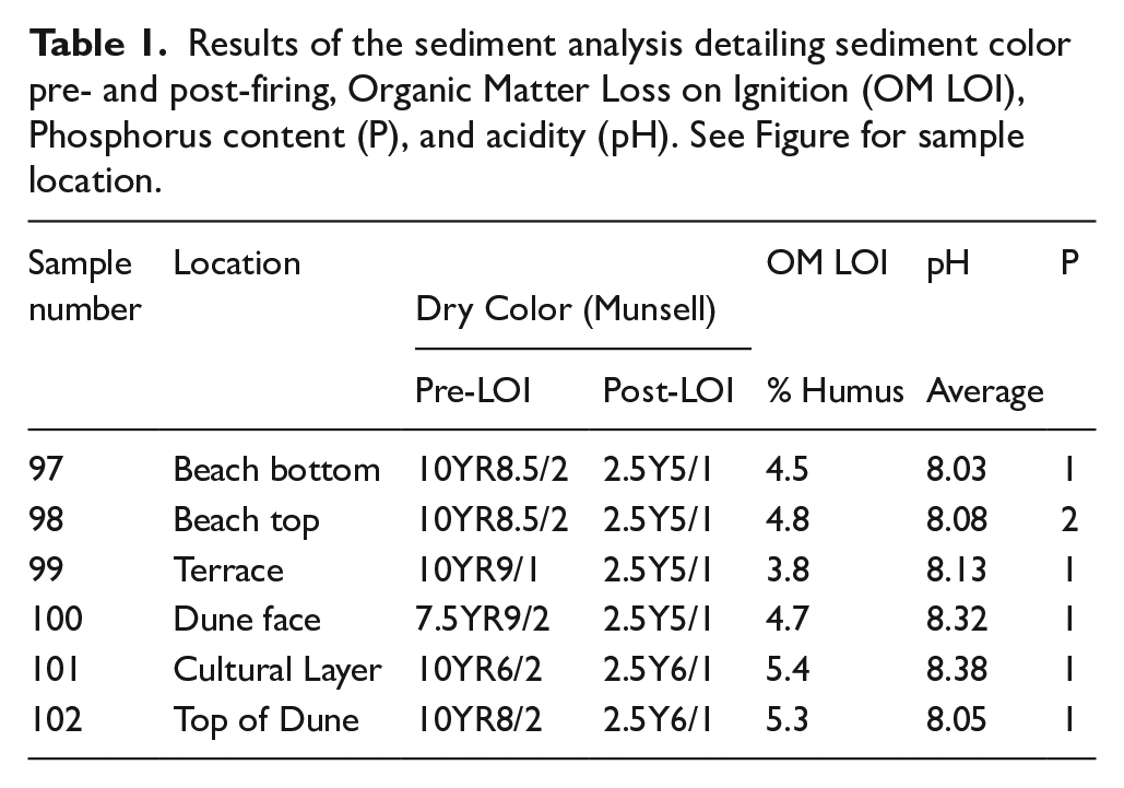
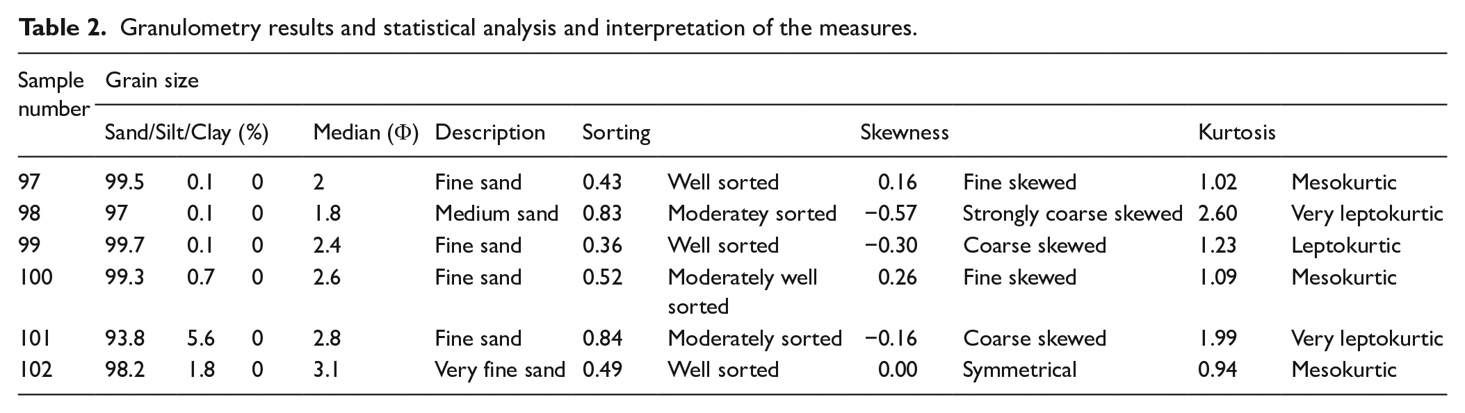
Tables 1 and 2 summarize the results of the geoarchaeological analyses. All samples consisted of fine sand, except for the top eroding portion of the swash zone - which revealed medium-grained sand – and the top of the sand dune that had very fine-grained sand. The background sediments are composed of biogenic carbonate grains including coral, coralline algae, foraminifera, shells, and shell fragments in varying proportions, with very few or no terrestrial grains. Grains are generally rounded. The sand is white (10YR9/1) or very light brown (10YR8/2) with pink grains, except for the cultural layer that presents a light brownish gray color (10YR6/2) and higher silt content. The composition of the silt was not analyzed. Sorting, skewness and kurtosis vary through the samples reflecting variability in the depositional and transport energies along the transect. Organic content was low throughout with the highest values registered in the cultural layer and the top of the dune. All samples were basic (pH from 8.03 to 8.38 in the cultural layer) and had no phosphate reaction except for a very subtle increase in the top of the eroding profile at the beach.
Results of the sediment analysis detailing sediment color pre- and post-firing, Organic Matter Loss on Ignition (OM LOI), Phosphorus content (P), and acidity (pH). See Figure for sample location.
Granulometry results and statistical analysis and interpretation of the measures.
The cultural layer
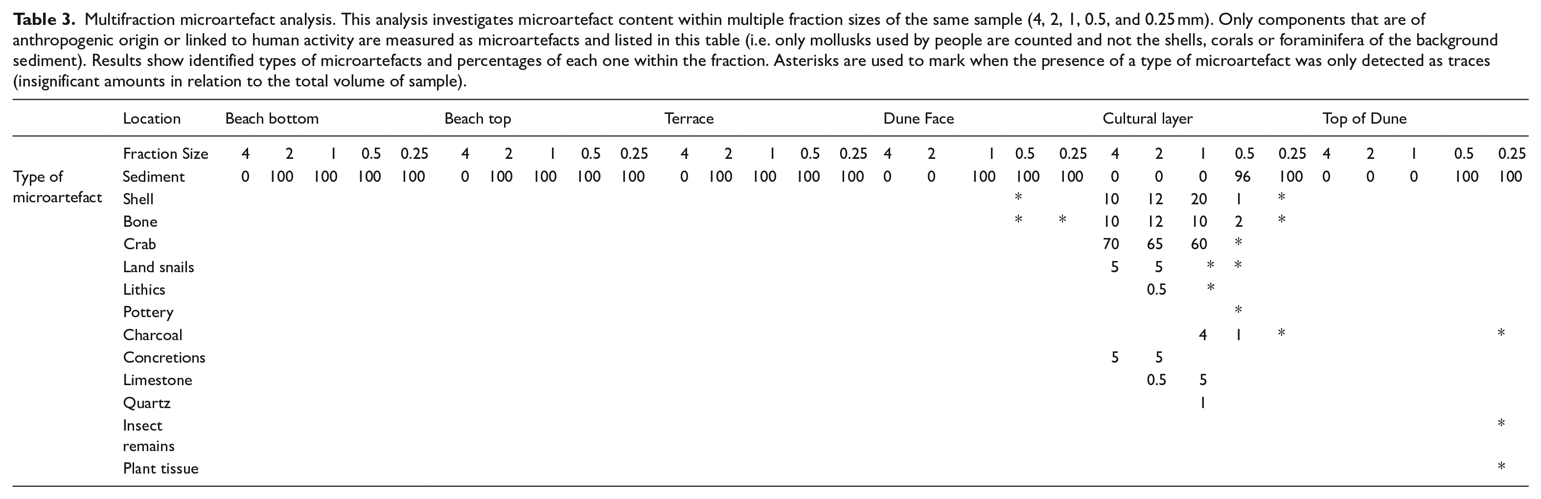
The cultural layer is exposed near the top of the sand dune ridge facing the ocean (Figure 4). The observed thickness of the layer in the studied location is 2.46 m. Microartefacts (Table 3) were quantified as part of the set of analyses performed because these components are a marker of the intensity of human activity over a land surface. Dominant presence of microartefacts was identified only in the cultural layer, where they constituted 100% of the coarse fraction (4–1 mm), and consisted mostly of food refuse (bone, shell, crab). Microartefacts also constituted 4% of the grains at 0.5 mm. Only traces were detected at 0.25 mm. Finer fractions (<0.25 mm) were not inspected. Traces of possibly culturally-related components, or remains associated to pedogenesis (e.g. plant tissue, insect cast remains, charcoal, bone, shell) were also observed in the 0.5 and 0.25 mm fractions of the layers just above and below the cultural one (dune face and top of dune). The background sediment, without the anthropogenic microartefact content, is moderately well sorted, fine-grained sand with a significant silt content, fine skewed, and with leptokurtic distribution. Observed under the microscope, the sediment grains, and composition are identical to all other dune samples which do not contain silt.
Multifraction microartefact analysis. This analysis investigates microartefact content within multiple fraction sizes of the same sample (4, 2, 1, 0.5, and 0.25 mm). Only components that are of anthropogenic origin or linked to human activity are measured as microartefacts and listed in this table (i.e. only mollusks used by people are counted and not the shells, corals or foraminifera of the background sediment). Results show identified types of microartefacts and percentages of each one within the fraction. Asterisks are used to mark when the presence of a type of microartefact was only detected as traces (insignificant amounts in relation to the total volume of sample).
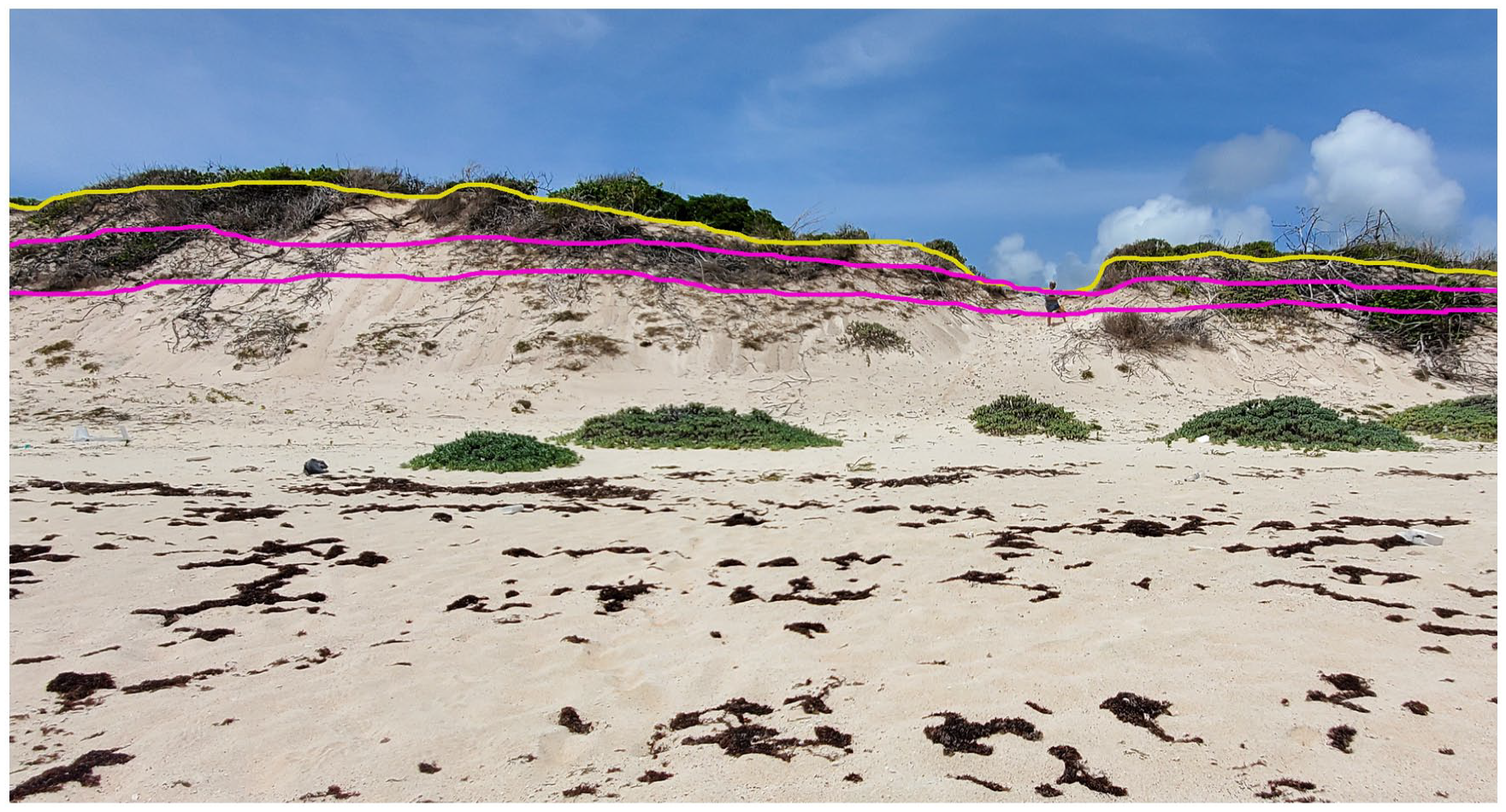
View of the sand dune ridge of Seaview from the ocean looking to the West. The yellow line marks the top of the sand dune, below the vegetation. The pink lines mark the cultural layer exposed near the top of the ridge. The vertical and horizontal extent of the cultural layer, while hard to see in this photograph (reason for which the lines are added) were evident on the field. For scale, the person near the top of the dune blow-out on the right-most third of the picture measures ca.1.5 m tall.
Moving inland along the transect (from East to West from the eroding dune profile, see Figure 3), the archeological (cultural) layer that was observed as a truncated layer near the top of the sand dune can be seen to continue past the end of the sand dune’s slipface. The dune has a large blowout on an area where the anchoring vegetation was lost. This deflation exposed the top of the cultural layer, which is more resistant to deflation given the presence of fine (silt-size) grains, thus demonstrating that the archeological strata are buried beneath the sand of the dune, and that, therefore, the sand accumulated after the cultural activity that formed the site of Seaview had ended.
Cultural artifacts are evident, eroding off the stratum and accumulating along the windward slope toward the base of the dune. Cultural remains include an abundance of very large gastropods with evidence of impact to remove the animal; large crabs – some with dog gnawing marks; fish and other vertebrate bones; large pottery fragments; lithic flakes; shell and stone artifacts; and macrobotanical remains, including wood charcoal. Several human and dog burials have also been rescued from eroding out of this profile.
Analysis, discussion, and interpretation
This section summarizes the results of the analyses, subdivided in sediments and geomorphology, and cultural layer.
Sea level change and paleolandscape
Long-term uplift studies report a rate of 0 m/Ma for Barbuda (Brasier and Donahue, 1985; Khan et al., 2017). Therefore, studies on relative sea level change can be used to understand paleolandscape dynamics through time. The Antillean area of Antigua, Martinique and Barbuda saw a change in sea level from −21 m (±1.1 m) to −0.7 m (±0.8 m) from 12 to 4 ka (Khan et al., 2017). Sea level rose quickly during the Early Holocene (12–8 ka), at a rate of over 10 mm/year. At that rapid rate, inundation overwhelms erosion or deposition and creates a geomorphology dominated by submerged or drowned features. During the Mid-Holocene (8–4 ka), sea level rise (SLR) slowed down, to around 2.3 mm/year. While this rate of sea level is still rapid, it is significantly lower than before. Relative sea level reached the eustatic 0 m (±0.6) between 2 and 1 ka and presented a high stand at +0.4 m (±0.6) during 1–0 ka (Khan et al., 2017). The rate of SLR has been minimal during the Late-Holocene (4–0 ka) (last 4 ky) (0.4 mm/year), allowing for sediment accumulation and stability of shoreline location. Relative SLR has accelerated for Barbuda in the last decades. The rate of SLR recorded a rate of 1.6–2 mm/year since 1950 (Bindoff et al., 2007; Church and White, 2006) (https://www.climatehotmap.org/global-warming-locations/antigua-and-barbuda.html#end4), and has increased to ca. 3mm/y during the 21st Century (https://climateknowledgeportal.worldbank.org/country/antigua-and-barbuda/impacts-sea-level-rise), exceeding the Mid Holocene rates and stimulating reworking of sediments and reshaping of coastlines (Burn et al., 2022).
Two Foot Bay, the seaward portion off Seaview, consists of a narrow insular shelf with a barrier coral reef approximately 200 m from the shoreline (distance measured using Google Earth). There is no available high-resolution bathymetric data for the area of Two Foot Bay. However, the existing nautical charts (https://www.gpsnauticalcharts.com/main/cb_gb_0254_2-barbuda-nautical-chart.html), suggest that water depth between the coral reef and the shoreline is ca. 4m with a low gradient reflecting the dip of the limestone bedrock. The 10 m isobath is located about 1.3 km from the modern shore. Considering the RSLs proposed by Khan et al. (2017), that isobath would have been a shoreline at some point between 9 and 7 kya. Given the low inclination gradient of Two Foot Bay between the 10 m isobath and the current shoreline, it can be expected the shelf drowned quickly during the Mid-Holocene (8–4 ka). Therefore, the extant barrier coral reef must be younger than 9–7 ka. In shallow inundated areas, such as submerged floodplains, nutrient availability from drowned terrestrial soils contribute to primary production and thus expansion of the biomass and productivity of marine ecosystems. Accumulation of sand at the shoreline must have started slowly as the marine ecosystems developed after 9–7 ka, supported by rich nutrient availability from drowned terrestrial soils, and accelerated with the growth and development of the coral reefs and their associated fauna, especially parrot fish which are well known major producers of fine- to medium-grained coral sand as biogenic sediment (Perry et al., 2015). There are no terrestrial sources of sediment transport eastward into Two Foot Bay.
Sea level remained relatively stable between 4 and 1 kya, allowing accumulation of autochthonous biogenic sand, landward wind transport of beached sediments, and growth of the sand dune retention ridge parallel to the shore. However, the high sea level stand, no more than 1 m above modern levels, reported during the last 1 ky (Khan et al., 2017) can be expected to have had destabilizing effects on the sand dune ridge, triggering coastal sediment mobilization. This higher sea level stand coincided with high sea surface temperatures (SST) and high storminess (frequent and high intensity) during the Medieval Warm Period (Knowles, 2008; Schmitt et al., 2020). Recent marine ecology studies for Two Foot Bay report the barrier reef to be mostly dead (Ruttenberg et al., 2018). While coral reefs are observed around the island, the coverage of living reefs is shockingly low, lower than 1% for some coral species. Many of the dead reefs are covered with macroalgae and fleshy algae. No reason or temporality for coral reef mortality has been reported (Ruttenberg et al., 2018). However, the environmental conditions registered during the Medieval Warm – high SST, high sea level stand, and high storm frequency and intensity – are all known triggers of coral reef decay and mortality (Ateweberhan and McClanahan, 2010; Ferreira et al., 2013; Glynn, 1990; Leggat et al., 2019). It is possible that the conditions of the Medieval Warm triggered the death of the coral reef at Two Foot Bay. Coral reef mortality increases wave energy reaching the shore (Sheppard et al., 2005) and reduces the available sediment budget given that parrotfish are reef-associated species. Parrotfish today are documented to cluster close to live coral patches, but very low elsewhere (Ruttenberg et al., 2018). Absence of parrotfish at or near Two Foot Bay would trigger a reduction in the available biogenic sediments nourishing the sand dunes. Thus, the erosion seen today in the sand dune ridges at Seaview can be explained as the result of ecological processes that started around 1000 years ago, leading to a progressive landward migration of the beach and the sand dune ridge. Even though Two Foot Bay beach was reported to be accreting during the period between 1996 and 2001 (James, 2003), landward migration of the shoreline is evident in Google Earth images between 2005 and 2020.
Settlement dynamics and paleolandscape
People that used pottery of the Saladoid series initially settled the coastal plain behind the already existing sand dunes at Seaview around 150 calBC (ca. 2.2 ka). At that time, the coral reef could be expected to be healthy and productive, already around 1.5–2 ky old. Given sediment accumulation, sea level stability and low storm incidence during those centuries of the Late-Holocene (Knowles, 2008; Schmitt et al., 2020), the local beach is expected to have been wider, making sediment more readily available for transport toward the sand dunes. The fact that the cultural layer is truncated (i.e. does not end in feather edge seaward) and exposed in profile near the top of the dune today, indicates that the original morphology of the dune is lost, and that the cultural deposit would have accumulated on what used to be the slip face of the dune, behind a now missing dune crest. We posit that the site was never located on top of the sand dune. Establishing human settlement on the backdune and leeside of the dune ridge, and not the top, preserves the dune itself. Removal of vegetation from the top of the dune causes blowouts and dune instability, and that is not evident in the cultural layer. The grain size and composition of the sand fraction within the cultural layer and immediately beneath it are compatible with the characteristics of the current dune’s slipface, thus supporting this assessment. Food refuse in the cultural layers at Seaview includes very large conch shells (Aliger gigas, Linnaeus 1758), West Indian top shells (Cittarium pica, Linnaeus 1758) and a variety of land and sea crabs, along with fish and other vertebrate and invertebrate species. The specimens of mollusks observed within the cultural layers are much larger than any specimen observed today of the same species, thus signaling the health of the local marine ecosystem at the time of human occupation in Seaview. The presence of conch shells also suggests that, aside from coral reefs, Two Foot Bay also had sandy bottom and seagrass ecosystems. These ecosystems would have been supported by nutrient availability from drowned terrestrial soils.
The latest radiocarbon date from Seaview places site abandonment between AD 960 and 1000. As mentioned above, it seems plausible that reef death, concurrent with increased storminess, higher SSTs and possible disturbance of offshore ecosystems, occurred around that same time. Preliminary assessment of stable isotopes of the calcium carbonate in late life-stages of Cittarium pica from Seaview suggest possible dramatic shifts in local SSTs and possible effects of storms over the offshore reefs (Perdikaris pers. comm 2022). While further analysis is required, this evidence suggests that a combination of environmental issues and coastal landscape change coincided with site abandonment. These changes invite the consideration of risk perception among societies during the Late Ceramic period in Barbuda, and thus consider decision-making and hazard mitigation during times of environmental uncertainty.
The geoarchaeological analysis suggests that the settlement was established on the sandy surface of the backdune and toward the silty soils of the coastal plain inland. The basic grain composition of the analyzed sample is the same biogenic sand originating from the sea and transported by the wind. The finer grain (silt) component in the cultural layer, absent in all other dune samples, is caused by anthropogenic input as are the coarser components (>0.5 mm). The present shape of the sand dune ridge - showing a steep gradient windward and a more gradual gradient in the leeside – along with the exposed presence of the thick cultural stratum near the top of the dune buried under clean sediments that accumulated after abandonment, are a clear indication of the modern instability of the ridge and the fact that the dune system is a relic morphology currently under erosional conditions. The original dune crest and windward slope, as well as the sandy shoreline concurrent to human occupation at the Seaview settlement, would have been at some location seaward from the current morphology, and have by now washed away. The characteristics at the waterline itself, showing a 1.5 m-high ridge with coarser grains at the top further demonstrates the erosive conditions of this location. The beach and the settlement are past a tipping point of recovery because there is not enough sediment budget to replenish the beach and the dunes.
Forecast for Seaview and the East coast of Barbuda
Field visits and observation of Google Earth images of Seaview after Hurricane Irma show that the storm caused significant geomorphological reworking of the beach. Wave action and wind from the storm removed sand from the sand dunes and accumulated it at the beach, but the longshore transport has reworked it by now. The Hurricane also caused loss of vegetation at the dune ridge, and recent land development has continued removing plant cover. Loss of vegetation from sand dune ridges allows sand to be more exposed to aeolian transport, therefore triggering more erosion and retreat (Feagin et al., 2015). Continued damage can be expected any time that strong waves impact the coast – from storms, hurricanes and long-distance waves generated in the Atlantic.
Moving inland, our field observations and RTK GPS measurements reveal exposed silty soils and limestone bedrock at or slightly above modern sea level. These areas are not yet inundated because of the protective barrier warranted by the presence of the coastal sand dune retention ridge which acts as a natural buffer against storms hurricanes and storm surge (Nehren et al., 2017). In the context of the present climate crisis and the forecasted climate impacts, the Intergovernmental Panel on Climate Change (IPCC) estimates the impact of sea level rise of 0.5–0.7 m by 2100 (Burn et al., 2022). Combined with increased intensity and frequency of high-magnitude storms, and the accelerated loss of natural barriers including sand dune ridges and coral reefs, the current and expected impacts of sea level rise over Barbuda are devastating.
In addition to natural processes, recent anthropogenic development on the coastal plain has caused deforestation for construction and impacts to the local vegetation, thus exacerbating aeolian sand transport and surface erosion. These impacts to the dunes are accelerating their loss, already proceeding fast at the shoreline, and further threatens the entire northwestern lowlands of Barbuda. As the sand dunes wash away, erode due to wind action, or are impacted for development, the low-lying flat plains could become rapidly submerged as soon as the ocean breaches the coastal dune ridges. This dire scenario, a preview of which was seen as floods caused by Hurricane Irma in 2017 (see flooded area marked in Figure 1), poses a threat to the traditional ways of life of Barbudans and their shelter security on their land, including the town of Codrington on the west of the island.
While hurricane Irma was a challenge for Barbuda, it opened the doors of opportunity to the central government to move in to Barbuda, change the land tenure system and bring in an unprecedented number of developers to invest in an unnecessarily large airport with no prior environmental assessment, and give 99 years leases to Barbuda’s Caribbean shoreline to outside investors, for luxury estates and tourist ventures. The uncertain conditions created post Irma, threaten Barbudan culture, identity and belonging (Boger and Perdikaris, 2019; Gould and Lewis, 2018). The resilient co-existence of people with the Barbudan seascapes and landscapes has seen its end. It is now just another island tropical paradise that others can profit from. The land act that protected Barbudans for 400 years was repealed in 2018 (Handy, 2020) and the massive bulldozers not only erase tangible and intangible cultural heritage but also further destabilize and weaken the island’s ability to overcome future large storms. Investors and tourists have the ability to be mobile and move as their interests change. Barbudans must live in Barbuda and weather all storms from the natural to the economic and the psychological. Disaster capitalism has dug its ugly claws and it is profiteering from the vulnerable people and an island in shock. The Antiguan government has a dual persona of an outward pretentious caring self to the ugly neocolonial abuser in internal matters. While a participant in wetland protection conventions such as RAMSAR and Escazú, the laws are not applied equally (United Nations Treaty Collection, 2018). Barbudans always respected conventions but now the external developers are allowed to move in and build artificial disneyfied landscapes in what are internationally protected regions (Perdikaris, 2020; Perdikaris et al., 2019, 2021). The central government instead of approaching the future with alternatives that make sense and work toward long term resilience, embraced luxury tourism and development as the singular focus for economic revenue (Perdikaris and Hejtmanek, 2020). This is an old-fashioned colonial approach that lacks imagination and innovation. The luxury estates are being built on what were areas flooded by Irma and regardless of storms, are expected to be underwater in the next 20–50 years. All the investments in tourism will not reverse the effects of climate change (Scott et al., 2012). As storms become more frequent and more intense the development by these investors seems even more pointless. It is nothing more than a massive and rapid destruction of vulnerable ecosystems and the erasure of traditional peoples from what used to be a distinct culture, unique in the Caribbean.
Conclusions
The goal of this analysis is to evaluate the relationship between coastal environments and ancient indigenous settlement, the effects of change over the archeological record in the present, and the potential threats of future sea level change to modern Barbuda. Through the multi- and interdisciplinary analysis of Seaview, this study has shown that (1) sea level stabilization after the Mid-Holocene allowed the formation of coral reefs, seagrass beds and other benthic ecosystems that allowed for biogenic sediment accumulation fostering the formation of sand dune retention ridges on the east coast of Barbuda. (2) These environmental characteristics, including rich marine food sources within 200 m of settlement, could have supported the establishment and flourishing of an indigenous settlement that started around 160 BC and remained in place for over 1000 years. (3) At some point between AD960 – 1000 (after 1 ka) occupation at Seaview ended. This change coincided with a period of increased storminess, higher SSTs, and possible coral reef mortality that could have negatively affected both food availability and sediment supply. 4) Lack of sediments triggered progressive sand dune erosion that continues today. The sand dunes at Seaview are past the tipping point of erosion, as lack of sediment availability in the system and the dominance of sediment transport and erosion lead to continual removal of sediments accumulated on land, including anthropogenic sediments. Finally, (5) looking into a future of rapidly changing climate, sea level rise poses a severe and devastating threat to the land- and seascapes of Barbuda. With the lowland coastal plain at or only slightly above current sea level, a rate of SLR comparable to Early Holocene rates, and rapid loss of sand dune ridges and coral reefs as natural barriers, it is just a matter of time before the lowlands and the Codrington Lagoon become transformed beyond recognition.
Archeological sites are not a scientific curiosity for researchers and heritage specialists. They are integral to the identity and culture of local people, can be a beneficial source of tourist income, and are records of real people-environment interactions through time that can help us gauge our decision making and activities toward a more resilient and sustainable future. Hurricane Irma not only forever transformed the Barbudan landscape and seascape but also the people of Barbuda (Perdikaris and Boger, 2022). Like many other islands in the Caribbean, extreme weather is the beginning of the disaster whose effects are everlasting in the form of political gains and land grabs (Boger et al., 2019; Maldonado et al., 2021). While the effects of climate drivers and natural processes and hazards continue to intensify the remodeling of the landscape, at Seaview multiple structures to welcome locals and visitors in camping holidays have been set up on top of the dunes that hold the history of life and death of early Barbudans. As deforestation accelerates dune erosion, roads are being cut, and modern feasting refuse piles up in what once was a lush sea grape landscape. The pressures of Disaster Capitalism (Klein, 2007) is changing the relationship of Barbudans with their land. While in the past people would declare the piece of land they wanted to inhabit when “the time was right,” now everyone is trying to put fences, foundations, and other structures in place so that no outsider will come to claim that land. Both outside developers and Barbudans are feverishly destroying the land to claim it for their own.
The erosion has accelerated, the reef has died, the sand has been pushed over the edge and lays in the very deep-sea bottom while the parrot fish have either perished or moved on. Sargasso seaweed is an additional challenge as it accelerates both the death of fish and corals, and threatens human health (ANSES, 2017; Fidai et al., 2020; Rodríguez-Martínez et al., 2020). As we witness a point of no return in the ecology and cultural heritage of Seaview, we feel an urgency to record what will in a very short time become a distant memory. Even though climate change and the usefulness of traditional knowledge for the conversations of adaptation and mitigation are hot topics today, many forget that our work impacts living people, facing life and death situations. Many have died: elders, family members, friends. Many others have migrated. These changes, compounded with multiple crises and the painful loss of cherished landscapes and seascapes, also mean the disastrous dismemberment of traditional communities and the loss of cultural diversity.
Understanding social vulnerability to climate change cannot be reduced to the identification of potential for impact (i.e. the combination of exposure and sensitivity). It must consider adaptive capacity too, and the social, political, and economic constraints that affect it. Citizens experience the consequences of climate change on all fronts, and every extreme event challenges their resilience and survival. As scientists we identify environmental threats, but for modern societies it is an interconnected web of economy, politics and environment. The case study of Seaview demonstrated that, while many individual events threatening shelter security, including individual storms, occurred throughout the life of the settlement, the site was not abandoned until both culturally relevant food and shelter security were considered at risk. What level of hazard was considered risky remains to be seen. What specific response options were considered and tried, aside from site abandonment, must still be investigated. However, living on the slipside and landward plain adjacent to coastal sand dunes is a traditional settlement practice throughout coastal communities in the Caribbean. The challenges faced by indigenous Caribbean communities in the past are once again faced by local and descendant communities in the present, but in contrast with the past, they are now constrained by legal, political, economic, and colonial systems that limit the applicability and success of traditional response systems and exacerbate climate-related trauma. The results of this analysis can be used to improve long-term management of the heritage resources of Barbudans and shed light on parallel challenges experienced on other tropical coastal locations.
Footnotes
Acknowledgements
The authors would like to thank the citizens of Barbuda for their welcoming and inclusive generosity. The Barbuda Council – Tourism Division for great collaboration, support and permits. Barbuda Research Complex (BRC) without which facility and resources this work would not have been possible. Barbuda Cottages for their warmth and logistic support. This work would not have been possible without the help, guidance and assistance of Dr. Reg Murphy, Mr. Calvin Gore and Mr. Shaville Charles. Many thanks also to the students of the Human Ecology Lab at Scripps Institution of Oceanography, and in particular Katrina Cantú and Eric Rodríguez-Delgado, for their support and assistance.
Author contributions
Conceptualization, Rivera-Collazo and Perdikaris; methodology, Rivera-Collazo; investigation, Perdikaris and Rivera-Collazo; writing—original draft preparation, Rivera-Collazo.; writing—review and editing, Perdikaris and Rivera-Collazo; funding acquisition, Perdikaris. All authors have read and agreed to the published version of the manuscript.
Funding
The author(s) disclosed receipt of the following financial support for the research, authorship, and/or publication of this article: This research was supported by RDAR-NIH COBRE and funding through the University of Nebraska-Lincoln.