
Abstract
The Pontine Marshes (Central Italy) are known for their long drainage history starting early in Roman times and culminating in their reclamation (bonifica integrale) by the Fascist’s regime under Mussolini, mostly in the 1930s of past century. The geology of this coastal wetland and causes for its drainage problems received limited attention till recently. We reviewed results from recent studies, identified still existing knowledge gaps and performed additional research to fill these, to produce a full description of the Holocene history and drainage of these marshes. Massive coring data that served to map the soils and surficial geology, observations in archaeological excavations, analytical data on soil and sediment characteristics, and radiocarbon datings allowed us to distinguish several phases in this history, with a main break in the early Roman Republican period with the first systematic drainage works. Earlier, natural processes brought about by sea level rise largely controlled its drainage. Once artificial drainage started, soil subsidence became an important process, aggravating the drainage problems. The bonifica introduced mechanical drainage, temporarily masking the impacts of subsidence. We quantified the historical subsidence using DTMs and developed scenarios for the impacts of sea level rise and subsidence in 2100 and 2200, assuming that this rise will be mitigated by a coastal defence system and enhanced capacity of the mechanical drainage. Our results demonstrate the important role of soil subsidence throughout the history of this wetland and need to include subsidence in scenarios for the impacts of sea level rise.
Introduction
The ‘Pontine Marshes’ in Central Italy, known as the Paludi Pontine (Italian) and, earlier, the Pomptinae Paludes (Latin, Pliny the Elder), is the name of a coastal plain wedged in between limestone mountains (Monti Lepini and Monti Ausoni) and a higher complex of marine terraces (Figure 1). This plain and the higher complex together form the Agro Pontino. The plain is a tectonic graben holding a thick sequence of Quaternary sediments (Accordi, 1966; Barbieri et al., 1999). It is particularly known for its reclamation during the Fascist era (see e.g. Frost, 1934), described as the bonifica integrale and heralded by the Fascist regime as one of the ‘Wonders of World Engineering’ (https://wondersofworldengineering.com).
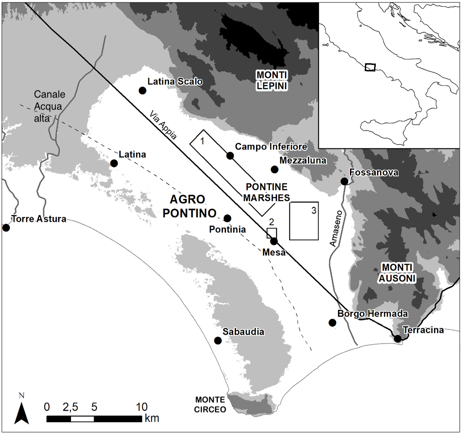
The Agro Pontino with topographic names of major locations and landforms. Areas studied in detail: (1) Fiume Murillo area; (2) Mesa area; (3) La Cotarda area. - - - = Southwestern border of Pontine Marshes.
Over the ages, many attempts were made to drain the plain. These have been described in an impressive number of publications of which the earliest date back to Roman times. The major Roman works took place in the fourth and early third century BCE and included the construction of the first major Roman road, the Via Appia, and an intricate drainage system. Concise descriptions of these Roman works were given by Linoli (2005), Walsh et al. (2014), and De Haas (2017). The dating of several elements of this drainage system is still uncertain and under study (De Haas, 2017; Magli et al., 2014). The next major attempt was by pope Pius VI (1775–1799), described by for example, Rocci (1995), while the abovementioned bonifica integrale took place under Mussolini’s regime. The bonifica has been described in detail (e.g. Alessandrini, 1935; Stampacchia, 2000) and concerned the whole of the Agro Pontino. It shaped an agricultural landscape, which intentionally referred to the grandeur of the Roman Empire and still dominates the plain. On the adjacent marine terrace complex, this landscape has nearly vanished, being replaced by heavily expanding industrial and urban areas (around Latina), and by huge complexes of modern greenhouses (in the south, near Sabaudia). The bonifica eliminated the malaria, which since long posed a serious threat to all inhabitants and had rendered the Pontine Marshes infamous throughout Europe (Caprotti, 2006; Protasi, 2016). Malaria briefly reappeared when the area was flooded by the Germans during the aftermath of the Second World War, to disappear shortly after the drainage system was restored.
Studies on the pre-bonifica history were largely based on descriptions by early authors, a large body of archival documents, and early topographic maps that are often inaccurate or schematic only. The studies that date from before the bonifica testify to the very rudimentary knowledge of the geology of the plain and to the lack of insight into the origin of the paludi (see e.g. Orsolini Cencelli, 1934). To some extent, this situation changed upon the bonifica since it included surveys of the superficial geology. However, the data acquired mainly served as technical base line information for the reclamation works and did not result in a deeper understanding of the origin of the paludi and the potential natural causes for the repeated failure of the earlier drainage systems. The problems were generally ascribed to mismanagement and linked to economic or social crises (e.g. Hofmann, 1956; Linoli, 2005). In summary, the studies dealing with its drainage history focus on political, economic and social factors, which is understandable since the area counts among the coastal plains with the best known, very rich and longest history in the world, the records going back to the Early Roman Republic. However, these studies pay limited or no attention to the natural processes.
In the seventies of past century, Dutch earth scientists from the University of Amsterdam became the first to pay serious attention to the surficial geology and Holocene history of the Pontine Marshes. This interest, rapidly shared by Dutch archaeologists, led to a series of PhD studies, and culminated in several projects by the University of Groningen (the Avellino project: http://avellino.gia-mediterranean.nl; the Minor Centres Project: http://minorcenters.gia-mediterranean.nl). Italian research on these topics remained scarce and largely limited to early studies connected with the bonifica. These studies produced a quite extensive literature covering various aspects of the surficial geology and palaeogeography of the Pontine Marshes. However, up to now no comprehensive analysis has been performed of its Holocene geological and drainage history, based on these studies, nor has been analysed whether and to what extent natural processes affected its drainage over the ages.
This paper concerns such comprehensive analysis, which is based on (a) a thorough review of its geological and drainage history in which already published results from the research described above are integrated, (b) additional new research combined with re-interpretations of earlier obtained data to fill knowledge gaps in the geological and drainage history that we identified in our review (a), (c) integration of the results from (a) and (b). Emphasis is on the Mid to Late-Holocene since these were the formative periods for the current Pontine Marshes. Its earlier history is only briefly dealt with.
The overall results of our analysis form the basis for an explanation of the past ups and downs in the ongoing struggle with the drainage of the paludi, which is exemplary for many other Mediterranean coastal wetlands. We discuss what lessons can be learned from this drainage history and show how the information gathered can be used to produce realistic scenarios for the impact of sea level rise in the next centuries.
The geological and drainage history of the Pontine Marshes
Review
The Pontine Marshes form part of a large area – the Agro Pontino – which is one of the larger low coastal plains in Central Italy. The Agro Pontino consists of a low horst with a set of Pleistocene marine terraces and a low inland graben – the Pontine Marshes. Other than in most Italian coastal plains (e.g. the Po, Arno, Ombrone, Tiber, Garigliano and Volturno deltaic areas), the input of siliciclastic sediment by rivers originating in the hinterland has been and still is very low with the result that the thick Quaternary fill of the graben largely consists of peats and very fine textured more or less organic clays, with common biogenic/chemical carbonatic strata, To this come pyroclastics, largely originating from the Volcano Laziale to the North, particularly in the deeper and older strata. Coarse textured sediments are only encountered in the southeast, where long-shore transport of such material resulted in the development of beach ridge barriers and associated aeolian deposits. The adjacent Fondi basin (to the east) is marked by a similar very low input of fluvial sediment and development of beach barriers and dunes. It is in this continued low input of siliciclastic alluvial sediment that the Pontine Marshes and the Fondi basin strongly differ from most other Italian coastal plains. Moreover, this also explains the comparatively massive soil subsidence and resulting drainage problems for which the Pontine Marshes are noted.
Until quite recently, more detailed studies on the Agro Pontino and the graben (the Pontine Marshes) remained very scarce and did not go beyond the level of detail shown in the geological map 1:100.000 which dates to the twenties of past century. The first modern and systematic information on the geology, soils and landscape of the Pontine Marshes was published by Sevink et al. (1984), who described the various marine complexes as well as a variety of Holocene deposits (see Figure 2). The soil survey, which formed part of this early study, provided important baseline information for later landscape archaeological studies, which included those by Voorrips et al. (1991), Attema (1993), Kamermans (1993), Van Joolen (2003), De Haas (2011), Alessandri (2013), and Feiken (2014). Further studies were boosted by the discovery by Sevink et al. (2011) of tephra from the Somma–Vesuvius Avellino pumice eruption (AV tephra), which occurred during the Early Bronze Age (c. 1900 cal yr BCE; Alessandri, 2019; Sevink et al., 2011, 2021). The ensuing Avellino project resulted in a large series of publications, which were recently summarized (Van Gorp and Sevink, 2023). An outline, largely based on these various studies, is presented below.
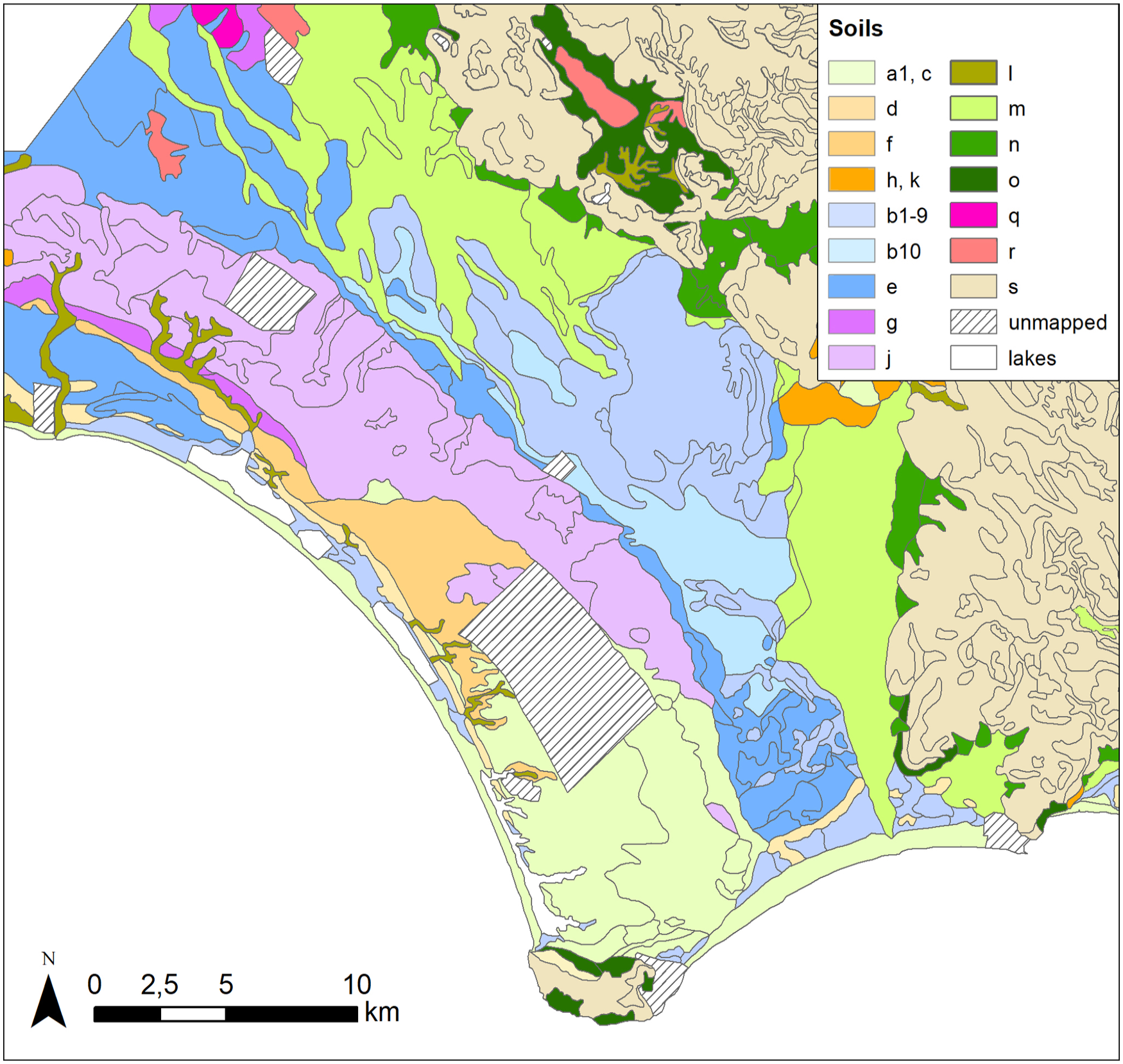
Main lithostratigraphic units of the Agro Pontino (after the soil map by Sevink et al., 1992).
Geological setting
In the Pontine plain, during the Late Eemian (MIS 5.3) a large marine complex formed, composed of a beach ridge and a lagoon that extended far to the NW. This complex was described by Sevink et al. (1982, 1984, 2018) as the Borgo Ermada marine complex (units e and b10 in Figure 2), dated to the MIS 5.3 stage by Hearty and Dai Pra (1986) and recently by Marra et al., 2020, 2023). During the subsequent Würmian glacial period, a system of fluvial incisions originated by backward incision of a branched river system (see T1, Figure 3). Its main branch – the palaeo-Amaseno, descending from the mountains to enter the plain near Fossanova – ran through a deep incision towards the sea, southeast of Terracina. A tributary river drained the central and northern parts of the plain and the adjacent mountains to join the paleo-Amaseno south of La Cotarda. Large karstic sources at the foot of the Monti Lepini fed this tributary that also had cut a deep valley, but apart from these incisions the Borgo Ermada lagoonal plain remained rather untouched (Sevink et al., 2018).
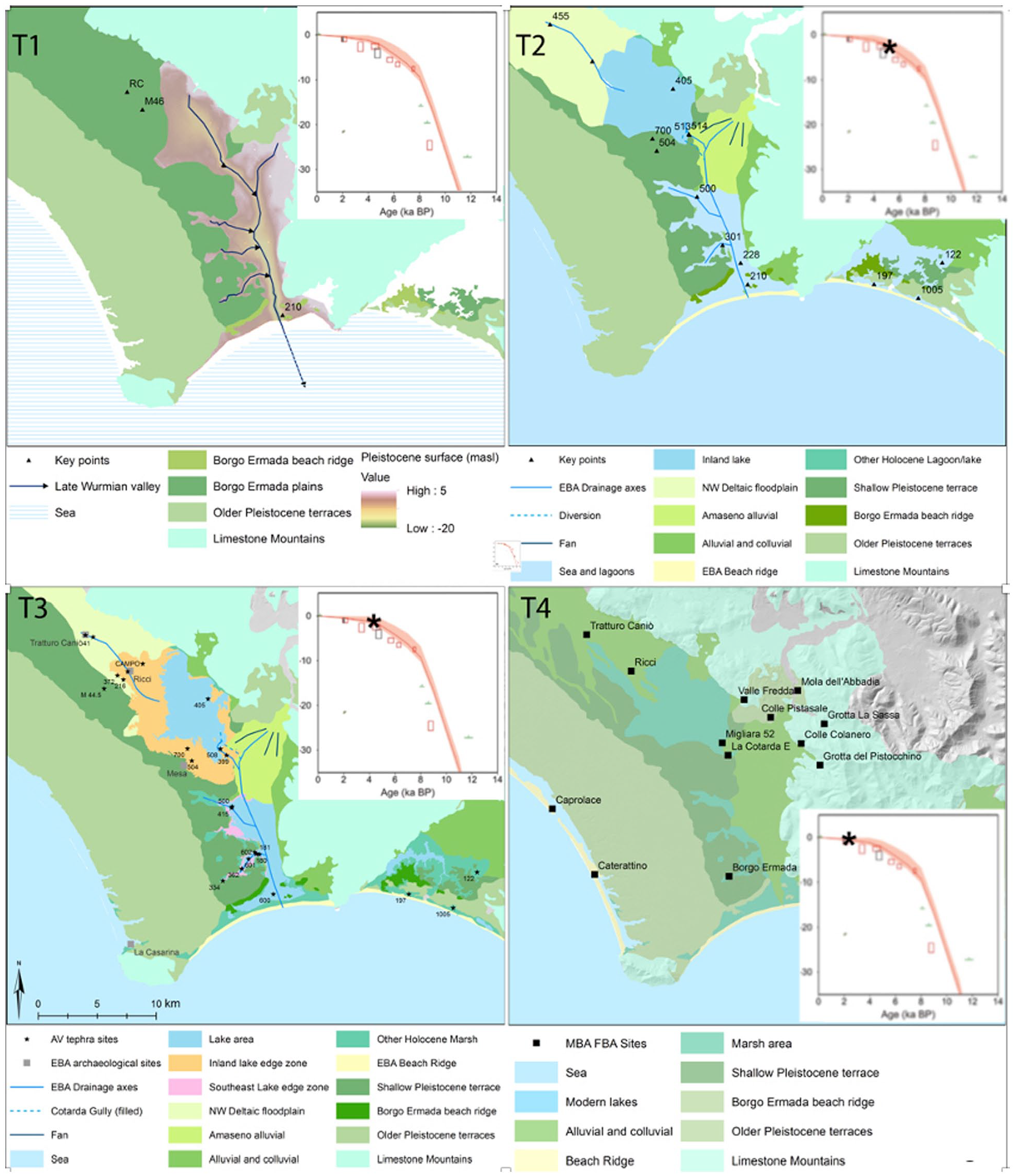
Palaeogeography of the Agro Pontino (maps from Van Gorp and Sevink, 2023 to which reference is made for explanation of names and numbers of sites indicated). T1 = Early Holocene/Late-Pleistocene (10–12 ka BP); T2 = Mid-Holocene until AV event; T3 = During and directly after AV event; T4 = After AV event (c. 0 BCE). Sea level curve for Tiber delta (Vacchi et al., 2016) with *indicating age of phase concerned. All maps have identical orientation and scale.
The Würmian sea level stood considerably lower than today (see T1 in Figure 3), but this changed during the Early Holocene when climate became warmer and more humid, and the sea level rapidly rose. By about 7 ka BP it had reached an altitude which was rather close to the current sea level and the rate of its rise declined (Lambeck et al., 2004, 2011; Vacchi et al., 2016). During this period of sea level rise, the Pre-Holocene landscape gradually drowned, and river incisions were increasingly filled in. In the coastal area near Terracina, sea level rise ultimately led to the build-up of a beach barrier and coastal lagoon, with a barrier system that closed around 2 ka BCE when sea level was at c. -1 m asl and its rise had truly slowed down (Van Gorp et al., 2020). This stage is depicted in Figure 3 as T2. In the west, in between Sabaudia and Torre Astura, a similar system formed but its closure was later (Alessandri et al., 2019). Because of its rising base level, the Amaseno river upon entering the plain built up a large deltaic system, which at some stage started to block the tributary river draining the interior plain, causing the gradual development of a large inland wetland with associated marshes and inland river deltas (T3 in Figure 3). The overall history of this wetland, which forms the core of the infamous Pontine Marshes, has been described by Van Gorp and Sevink (2019), Van Gorp et al. (2020), Van Gorp and Sevink (2023).
Characteristic for both the coastal areas and the inland wetland was the predominance of organogenic sediments (peats and calcareous gyttjas) over clastic sediments (clays), due to the low influx of clastic material from the hinterland. This changed during the Late Bronze Age (around 1 ka BCE), as is evidenced by the rapid expansion of the fluvio-colluvial ‘fingers’ (see Figure 2) and high rate of sedimentation deduced from the archaeologically dated sedimentary sequence in the sections studied. These testify to the massive supply of eroded soil material to the depositional fluvial system in the plain (see e.g. Bakels et al., 2015; Feiken, 2014; Feiken et al., 2012). In the northwest, these fluvio-colluvial sediments (unit m in Figure 2) ultimately largely covered the sediments belonging to the Holocene marsh sediments (mostly peats and described as the Terracina complex, c.f. Sevink et al., 1984) and to the Borgo Ermada marine complex (mostly heavy clays). Further SE they formed low elongated levees that extended far into the central wetland, where peat growth continued (see Figures 2 and 3(T4)). In Roman Republican times, the massive influx of eroded soil material ended, and the levees were settled but locally sedimentation continued along still active canals and canalized rivers (Feiken, 2014; Tol et al., 2021). In the paleo-Amaseno valley the influx of eroded soil material led to a continued aggradation of the deltaic fan and its further extension towards Terracina, which is depicted in Figure 3(T4) (after Van Joolen, 2003).
Drainage history
Major controls over the drainage conditions in the coastal area inclusive of the paleo-Amaseno valley were (a) the sea level and its Holocene rise (see Figure 3(T2)–(T4)), (b) the subsidence (mainly by compaction) of the overall peaty fills of the deep Amaseno paleo-valley (Serva and Brunamonte, 2007; Van Gorp et al., 2020) and (c) the further expansion of the Amaseno fan (Sevink et al., 1984; Van Joolen, 2003). The history of the interior plain is far more complex, since upon the damming of its early outlet near the Casale Mazzocchio (see Figure 4) a new outlet further south must have developed when the water level reached an altitude that exceeded that of lows in the Borgo Ermada lagoonal plain to the south. This probably happened later during the Bronze Age or Early Iron age (ca. 1000–900 BCE, see 4.2.3) and the new outlet may have persisted till the Roman Republican period. This is suggested by the fact that the earliest (Roman or even earlier) complex drainage system consisted of a grid of canals and ditches with a N-S/E-W orientation, which may have been linked to this new outlet. In this phase a canal parallel to the later Via Appia but slightly further north (see Figure 9) seems to have been the main axis of the system (De Haas, 2017).
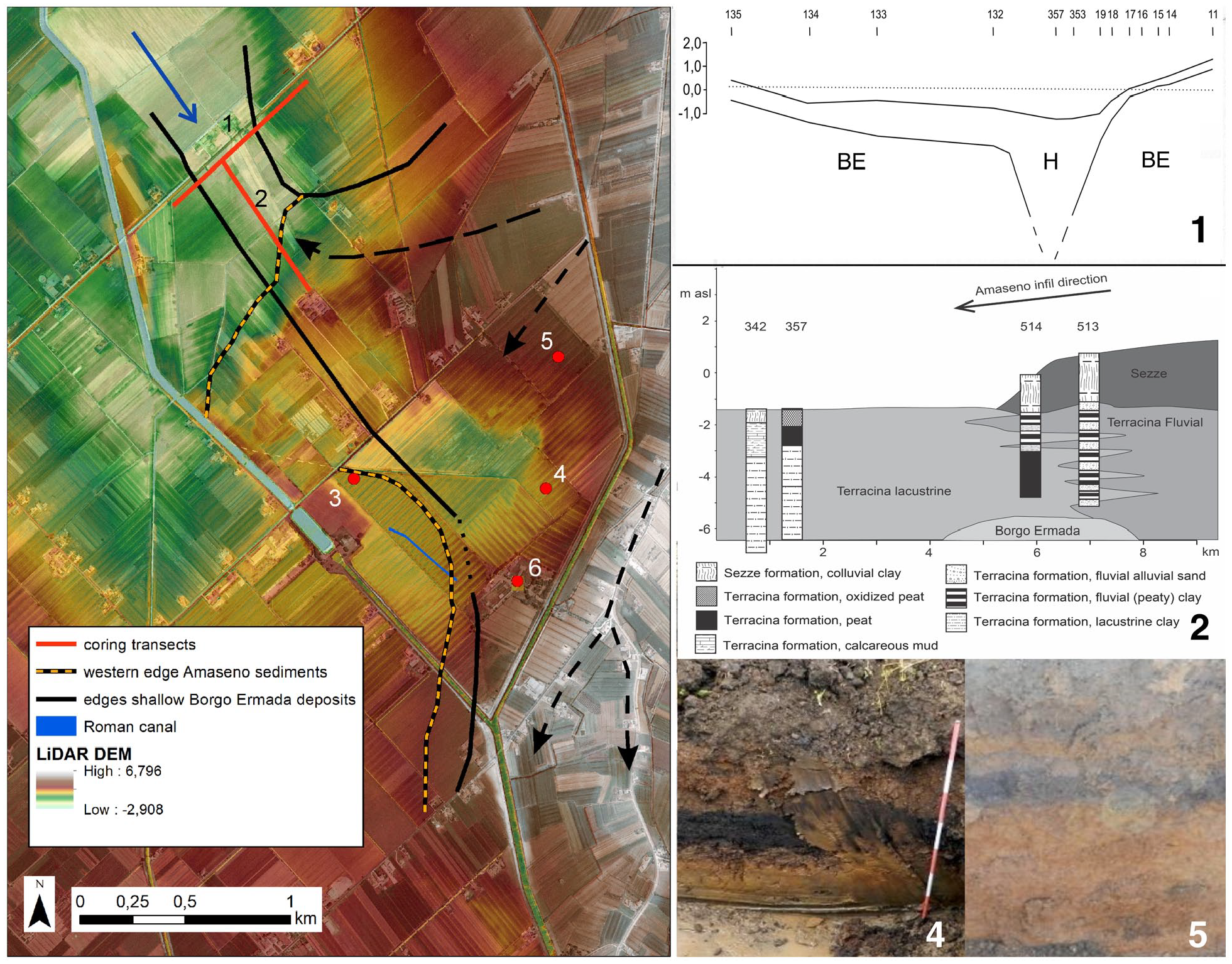
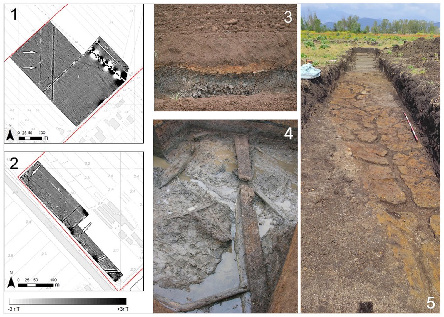
The La Cotarda area. Map showing the boundaries of the deep fluvial incision through the Borgo Ermada complex, the location of the cross sections (1 and 2) and trenches (3, 4, 5), and extension of the Amaseno sediments. Black arrows indicate main sediment-transporting courses of Amaseno River; blue arrow indicates ‘Murillo River’ draining the interior area. 1 = section 1 (H = Holocene sediment; BE = Borgo Ermada complex); 2 = section 2 from Van Gorp and Sevink (2023); 3 = location of excavation area at Casale Mazzochio (for details, see Figure 5); 4 and 5 = trenches with fluvio-colluvial Amaseno sediment over peat, over fluvial Amaseno sediment. 6 = location of Casale Mazzocchio Estate. For details and core descriptions, see Supplemental 1.
In the late fourth/early third century BCE the Via Appia and a canal running along it through the Pontine marshes (the so-called Decennovium, see Figures 1 and 9) were constructed and became the main axis of the Roman drainage system (De Haas, 2017; Walsh et al., 2014). Whether this change was induced by the further growth of the Amaseno fan, also damming the new outlet and necessitating a new approach with an outlet that was dug more to the south through more elevated parts of the Borgo Ermada lagoonal flats to reach the low-lying coastal system, is not clear but seems likely. Another strategy from that period was to prevent the streams in the north to flow towards the central and lowest part of the plain by developing a system of diversion canals that crossed the plain to run along its higher southwestern border (Sevink et al., 1984). These show up in the form of fluvio-colluvial ‘fingers’ (see Figure 2, units m) crossing the plain. Such canals may even have been dug through the marine terrace complex to the south: the Canale delle Acque Alte (in the NW, see Figure 1) and the Rio Martino (see Figure 9). The Fiume Sisto (see also Figure 9) may also well date from this period but still doubts exist about its age. Evidence for a truly early existence (e.g. Roman Republican) of such canals is scant and the topic is still under investigation (De Haas, 2017).
From the Roman Republican period on, drainage of the Pontine Marshes became increasingly anthropogenically controlled, the natural processes mentioned above playing a lesser role. This period, which lasted till the bonifica integrale, can be described as a continuous struggle to keep the marshes drained, with many ups and downs, but with downs prevailing, that is, impoverished drainage, expanding marshes and declining population because of problematic environmental conditions. As for example described by Gruppuso (2022), for the local people living their traditional life in the paludi, the downs may well have looked far less dramatic than has been suggested in stories heralding the achievements of the bonifica integrale. In the literature, the ups are typically looked upon as based on the visions and perseverance of rulers and wealthy financers, amongst which several popes (see Linoli, 2005; Walsh et al., 2014). Remarkably, rather limited attention is paid to the inexistence of suited hydraulic techniques for draining the area in the period preceding the bonifica integrale, apart from Frost (1934) who indeed described the inadequacy of the earlier drainage systems. Relevant techniques could have included windmills (like in the Netherlands, since the 16th century), colmatage (such as in the Tuscan Grosseto plain, from the second half of the 18th century onwards, De Silva et al., 2013), and hydraulic steam pumps (from the second half of the 19th century in function in Veneto, see Novello and McCann, 2017). It took until the thirties of the 20th century to construct a system of canals and pumping stations that finally drained the paludi.
Still existing knowledge gaps
The Pontine Marshes thus consist of two parts that fundamentally differ with respect to their origin and drainage history: an interior low-lying area with a formerly extensive wetland and a coastal area with the associated Amaseno fan. Main driving processes in the coastal area were sea level rise and soil subsidence, both of which were extensively described in the literature cited and needed no further attention in this context. In the interior area additional processes played a role and attempts to drain this area were much more complex. Crucial was the strong control over its natural drainage by the aggrading Amaseno fan (Van Gorp and Sevink, 2023), which has not yet been studied in detail. A significant knowledge gap still existed regarding the phasing of the build-up of the Amaseno fan and damming of the valley draining the interior area near La Cotarda (see Figures 2 and 4), and the related drainage history. Specific related topics include (a) the impacts of the damming on the interior area and (b) the development and chronology of early Roman (‘pre-Appia’) and earlier drainage systems in this interior area.
As discussed by Van Gorp et al. (2020), a fair indication for the overall magnitude of the subsidence due to the bonifica integrale could be obtained from the detailed topographic data produced for that bonifica integrale (Alessandri et al., 2022) and its comparison with a recent Lidar-DTM (2011). This soil subsidence, directly linked to the reclamation works, clearly plays an important role in the drainage problems encountered in the interior plain, as has also been described by Serva and Brunamonte (2007). Their study was less detailed than that by Van Gorp et al. (2020) and not based on deep insight into the surficial geology of the plain. Far less is known about the early soil subsidence and its role in the drainage problems, notably during the Roman period, and this forms another knowledge gap.
A potentially relevant factor is climate, which over the period concerned showed considerable variation and in terms of net precipitation and seasonal peaks in discharge may have led to significant variation in erosion and sedimentation. It is only recently that detailed information on the Holocene climate in this part of the Mediterranean became available (Di Rita et al., 2018). This explains the very limited attention which has been paid in previous studies to the potential link between climate and the drainage history of the Pontine Marshes. Whether and to what extent variations in climate played a role in this history might be deduced from available palaeoecological data (e.g. Bakels et al., 2015) and this is another relevant topic.
Methods and techniques
This section concerns the research on the still existing knowledge gaps and the production of the scenarios (see the introduction above). This further research includes recent corings and analyses, earlier unpublished corings, and re-interpretations of earlier analytical data, notably radiocarbon datings and palynological analyses, for which methods used are also described. For other methods and techniques used in the earlier published research, we refer to the literature cited from which these data are derived.
Field methods primarily concern the soil corings (by gouge corer to allow for the study of undisturbed cores, or by Edelman corer) performed in 2020 and later. A smaller number of observations was made in trenches dug for a large archaeological excavation at Casale Mazzocchio, executed in 2021). Core and trench locations were recorded by GPS and altitudes of the ground level were taken from a recent LiDAR-based digital elevation model (Ministero dell’Ambiente e della Tutela del Territorio e del Mare, www.pcn.minambiente.it). Soils and sediments encountered were described using the standardized FAO system for profile description. Study areas and locations are indicated in Figure 1, while coordinates of relevant corings and sites are given in Supplemental 1.
The FAO system was also used for earlier core descriptions. The latter concerned a very large archive of mostly unpublished corings by the first author, accumulated since the seventies of past century. This archive included the hundreds of corings in the Pontine Marshes on which the soil map by Sevink et al. (1984) was based, and other corings performed within the scope of later, mostly archaeological studies (e.g. Feiken, 2014; Van Joolen, 2003). Locations of the early corings were taken from the 1:25.000 topographic maps on which they were originally recorded. Locations of later corings were established by GPS. Altitudes were derived from the LiDAR-based DTM mentioned above.
Samples for radiocarbon dating, for which results are presented in this paper (see Table 1), were handpicked from gouge core samples or from samples taken in pits and consisted of recognizable terrestrial plant macro remains (seeds, leaves, etc.). They were analysed at the Centre for Isotope Research (CIO) of the University of Groningen, The Netherlands. For an extensive description of the methods and AMS systems (GrA and GrM) used at CIO, see Dee et al. (2020). 14C dates given (in yr BP) were based on the standardized calculations, including correction for isotopic fractionation (Mook and Van Der Plicht, 1999; Van der Plicht and Hogg, 2006). Dates have been calibrated using Oxcal2 4.4 and the calibration curve Intcal 2020 (Reimer et al., 2020), implying that earlier (pre-2020) radiocarbon datings were recalibrated.
Radiocarbon dates of sediment predating the alluvial Amaseno sediment.
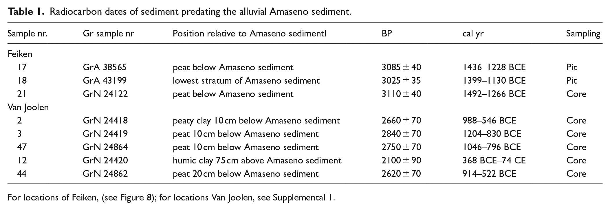
For locations of Feiken, (see Figure 8); for locations Van Joolen, see Supplemental 1.
From several suitable sections and cores pollen samples were taken in the past. Base-line data for two of these, which concern samples from large pits, were reinterpreted and the results are presented and discussed in this paper. The samples were treated with 10% KOH and 37% HCl. Mineral material was removed using a bromoform/ethanol (specific gravity 2.0) solution and residual sample material was acetolysed. To every sample Lycopodium spores tablets were added for the determination of the pollen concentration. Diagrams were produced using the Tilia software (Grimm, 1991).
The impact of future sea level rise on the altitude of the land surface in m a.s.l. was estimated using detailed topographic data (1:5.000 topographic map from 1928 produced for the bonifica and LiDAR data from 2011, which served to establish the subsidence over this c. 80 years period (Van Gorp et al., 2020). The expected subsidence till 2100 CE was assumed to be equal to the subsidence over the period 1928–2010 (2008/2011) and that over the period till 2200 CE to be twice that value. For the methodology used for this approach and a detailed analysis of the potential errors in the calculated subsidence, linked to systemic errors in this comparison of two fundamentally different data sets, reference is made to Van Gorp et al. (2020), who showed that these errors are insignificant relative to the overall values for this subsidence.
Locations of places, rivers, mountain chains, etc. mentioned in the text can be found in several Figures 1, 3, 8 and 9, since their number was too large to give these all in a single figure.
Results and discussion
These results concern the research that aimed to fill the knowledge gaps described under 2.2 and deals with the corresponding topics.
The build-up of the Amaseno fan and damming of the tributary valley near La Cotarda
Van Gorp and Sevink (2019), Van Gorp et al. (2020), Van Gorp and Sevink (2023) already provided general information on this damming and sketched the transition from the inland wetland to the Amaseno fan (see also Figure 4(2)), while Van Joolen (2003) was the first to establish a chronology for the build-up. Novel information on the local geology has been obtained from trenches that in 2021 were dug within the context of an archaeological survey at Casale Mazzocchio and from the ensuing excavation, and by subsequent corings in the area to the NW. The archaeological survey and excavation are described in unpublished reports by Alessandri et al. (2021a) and (2021b), available upon request at the Soprintendenza Archeologia, Belle Arti e Paesaggio per le province di Frosinone e Latina) and in Melandri (in press). Observations on the nature and stratigraphy of the sediments in the trenches and excavation, presented in this paper, were made by Sevink and Alessandri. Locations of the corings, trenches, and excavation, and the core descriptions (including those of earlier unpublished corings, see section 3) can be found in Supplemental 1.
As described above (section 2.2), near La Cotarda an incised valley existed, cut into the Borgo Ermada complex (MIS 5.3). This valley has been gradually filled during the Holocene with contrasting sediments: fine grained, often highly organic sediments characteristic for low energy, lacustrine to marshy environments and fluvial to fluvio-colluvial sediment deposited by the palaeo-Amaseno. We thus could distinguish three major types of material in the survey, excavation and corings (for an extensive description of these materials, see Sevink et al., 1984):
- Late Pleistocene lagoonal sediments forming part of the Borgo Ermada complex (MIS 5.3). Marked by their fine texture (mostly heavy clay), strongly developed vertic soil with prominent pseudogley features, and the abundant occurrence of secondary carbonate concretions, which often contain well-preserved Cerastoderma glaucum shells, testifying to the lagoonal origin of the sediment.
- Holocene Amaseno sediment recognized by its typical colour (uniformly brown to reddish brown, no distinct hydromorphic features), texture (varied and with a significant sand fraction) and mineralogical composition (significant amount of sand-size pyroclastic material, notably pyroxenes, and of quartz grains that are derived from the nearby Priverno sands, see Sevink et al. (1984) and Figure 2). Distinction is made between a) relatively well-sorted and stratified older fluvial sediment with varied texture, and b) non-sorted, younger, relatively fine textured and homogeneous fluvio-colluvial sediment. The two types of sediment are commonly separated by a layer of black highly organic sediment to peat (see Figure 4(4), (5)). Sediment indicated in Figure 4(2) as ‘Terracina Fluvial’ is typically older sediment, interfingering with the Holocene ‘marsh’ sediments (see below, in Figure 4(2) indicated as ‘Terracina lacustrine’).
- Holocene ‘marsh’ sediment of the Terracina complex, marked by the absence of any significant soil formation, limited physical ripening, and very low content of silt or sand-sized siliciclastic material. Their composition ranges from highly organic peat to highly calcareous gyttja, often with abundant shells of freshwater molluscs. Clastic sediment is rare, if occurring consists of humic heavy clays, and is largely limited to the centre of the fluvial incision that drained the interior plain and to the latest phase of sedimentation (clayey topsoil). In these marsh sediments, the AV tephra layer is widely encountered, generally at a depth of less than 1 m (Sevink et al., 2020, 2021). In Figure 4(2) it is indicated as the ‘Sezze formation’.
In earlier studies, the deep Würmian incision was only schematically indicated (Serva and Brunamonte, 2007; Van Gorp and Sevink, 2019; Van Gorp et al., 2020; Van Gorp and Sevink, 2023) and its northern boundary remained uncertain. Based on the recent observations mentioned above (trenches and corings), the boundaries could be defined more precisely, as well as the westward penetration of the Amaseno sediment into this incision. These are both depicted in Figure 4. The cross section 1 shows the dimensions of this incision of which the total depth remained uncertain (> 6m).
Altitudes of the adjacent surface of the Borgo Ermada complex, bordering this incision, vary from about 0.5 m asl in the west to over 2 m asl in the east (see Figure 4(1)). The Amaseno sediment reaches a variable altitude, apparently due to the branched nature of the streams that formed the deltaic fan. The most northern branch is indicated in Figure 4 and formed a thick deposit with incidental intercalations of peat. A major, more southern branch reaches altitudes of up to +4 m asl and it was this branch that ultimately fully blocked the outlet. In the intermediate area a major archaeological site was encountered on the southern slope of the incision (site 3 in Figure 4).
The Casale Mazzocchio archaeological site is located along the border of a marsh with some shallow open water, depicted in Figure 5 (details). The archaeological stratum rests on a thin layer of Holocene clay holding the AV tephra layer, (c. 1900 cal yr BCE) which in turn rests upon clayey sediments, forming part of the Borgo Ermada complex (MIS5.3) and marked by the common occurrence of a dense petrocalcic horizon. The ground surface of the settlement is at about 0.5 m asl. suggesting that the maximum altitude of the inland water level was at about 0.5 m asl. Lower parts of the sloping area were clearly marshy or with open water, into which wooden platforms had been constructed as evidenced by numerous postholes, several well-preserved poles, and abundant very well conserved artefacts (bones, pottery, wood) that had fallen into the marsh/water.
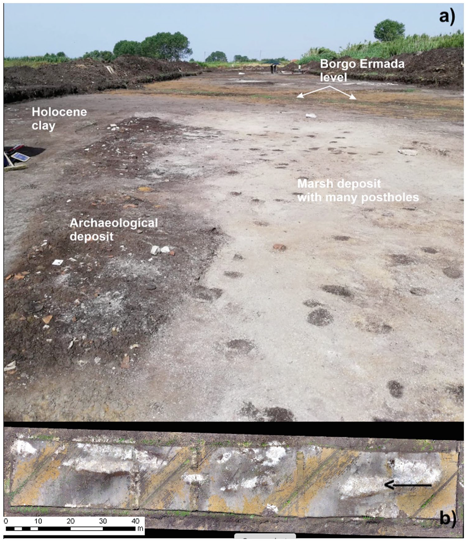
Excavation at Casale Mazzocchio. (a) Overview showing the stratigraphy of the site. (b) Vertical picture of the excavation with arrow indicating direction of view in (a). For details, see Supplemental 1.
The oldest archaeological materials encountered date from the Middle Bronze Age (Melandri, in press; Alessandri et al., 2021b), and the site was deserted around the transition from the Bronze Age to the Iron Age, which falls around 950 BCE in this part of Italy (Pacciarelli, 2001). It was subsequently covered by c. 0.5 m more recent clayey sediment, which in part consists of younger Amaseno sediment (see above) that laterally grades into the reddish brown fluvio-colluvial material that is widely encountered further upstream (see Figures 2 and 4). The observations thus indicate that the deposition of fluvio-colluvial materials by the Amaseno started around that time. Further towards the NW the younger Amaseno sediment even reaches higher altitudes (see Figure 4) that is, up to about 1.5 m asl, testifying to the importance of this more recent fluvio-colluvial material for the blockade of this outlet.
In the SE, the major Amaseno branch even more effectively blocked the incision, the terrain gradually running from ca. 2 m asl, with the Borgo Ermada sediment at ca. 1.5 m asl, to over 4 m asl. In combination with the observations at the archaeological site, this strongly suggests that this 1 m asl formed a threshold value for the development of a new outlet of the interior wetland from the transition of the Final Bronze Age to the Iron Age onwards.
The impacts on the interior area
The gradual damming of the outlet must have led to an equally gradual expansion of the wetland in the interior area and will have had a major impact on early inhabitants of the area and their land use. A general description of the gradual rise of the water level in this wetland system, the maximum level reached, and the associated expansion of its area has already been given Van Gorp and Sevink (2023). Here attention will be paid to early drainage attempts (prior to the AV eruption at ca. 1900 cal yr BCE), as observed near Mesa and Pontinia, the development of the Murillo drainage system, and the development of a more recent outlet.
Early drainage activities and their background
Information on early drainage was derived from previous research. New evidence stems from the Mazzocchio excavation, extensively discussed above (4.1).
At Mesa, geophysical surveys followed by systematic corings by Sevink and De Haas showed the existence of ring ditches presumably surrounding habitats and a straight ditch running over a considerable distance (at least several hundreds of metres). These ditches were filled with highly organic pyritic sediment and held a distinct layer of AV tephra, implying that they were dug during the early onset of the Bronze Age or earlier (Tol et al., 2021), when the maximum water level in the inland wetland had not yet been reached (Figure 6(1), (2)). They were later flooded and filled in. Later, in the southern border zone of the interior wetland near Pontinia, similar small, apparently straight ditches (between 50 and 70 cm deep) were found by the same authors (De Haas et al., in press), also filled with black pyritic organic clays holding the AV tephra layer and covered by a thin more recent cover of clayey sediment. Earlier, at the site Migliara 44.5, where the AV tephra layer was found for the first time (Sevink et al., 2011), small straight ditches with identical fill had been found (Figure 6(3)). They were extensively described by Feiken (2014) who did not recognize these as man-made ditches. Remarkably, at the Casale Mazzocchio excavation a very similar shallow ditch-like depression was found, also with a fill holding the AV tephra layer. The tephra layer at this site had already been identified as such by the first author (Sevink et al., 2020). In this case, it was not clear whether the ditch was natural or dug by man (Figure 6(5)), but an anthropogenic origin – a ditch – seems most likely considering the very straight shape of this depression.
Pre-AV anthropogenic activities. 1 and 2 = Early ditches with fill holding AV layer (indicated with arrow) (From Tol et al., 2021); 3 = Small ditch with fill holding AV layer near Migliara 44.5; 4 = Worked tree stems and branches at Campo inferiore underneath AV layer; 5 = Small ditch-like depression holding AV layer at the Casale Mazzocchio archaeological site.
All ditches thus predate the AV tephra layer, which dates from c. 1900 cal yr BCE. In the central part of the inland wetland this AV layer is always found at some depth below the top of the natural wetland deposits, evidencing that the water level in this area had not yet reached its maximum altitude and the outlet near Casale Mazzocchio was still functioning. Other evidence for such ‘early drowning inhabited landscape’ was found at Campo Inferiore, one of the earliest locations where the AV tephra was found (Sevink et al., 2011). Here, a stratum with large numbers of worked tree stems and branches had been found below the AV tephra layer and covered by sediments that clearly were formed in an open shallow-water environment (see Figure 6(4)). In none of the areas described, archaeological materials allowing for a more precise archaeological dating (based on e.g. pottery typology) of these ditches and human activity were found.
Evidently, the question arises whether this drowning can be fully ascribed to the build-up of the Amaseno fan or had a climatic background, or both. Answers to this question might eventually be found in palaeoecological analyses that formed part of the Avellino project mentioned above and aimed to assess the impact of human occupation on the vegetation just before and just after the deposition of the AV tephra (Doorenbosch, 2023). Thus far, these are the only systematic palynological analyses for the Mid and Late-Holocene of the Pontine Marshes. Unfortunately, the period represented by most analyses is too short to offer the required information for the subject discussed here, while for some older sections studied no reliable 14C datings were available (Sevink et al., 2013). Only two diagrams offer such information: Ricci and Mezzaluna (Bakels et al., 2015). The pollen data have been re-interpreted to distinguish between presumably local wetland vegetation and the dry land vegetation.
At Ricci, peaty deltaic fan deposits holding the AV layer are covered by fluvio-colluvial deposits that form part of the Murillo system (see 4.2.2), while the Mezzaluna site is in an area where peat growth continued until recently and the AV layer was deposited in more open water, in which calcareous gyttja accumulated. Earlier palynological studies for the Agro Pontino (Barbieri et al., 1999; Eisner and Kamermans, 2004) either lacked sufficient age control, 14C datings of the cores concerned were unreliable (Sevink et al., 2013), or sections of Holocene age in these cores were not studied. Figure 7 presents the shortened and adapted versions of the Ricci and Mezzaluna diagrams. These are discussed, followed by a comparison of the results with those from the study by Di Rita et al. (2018).
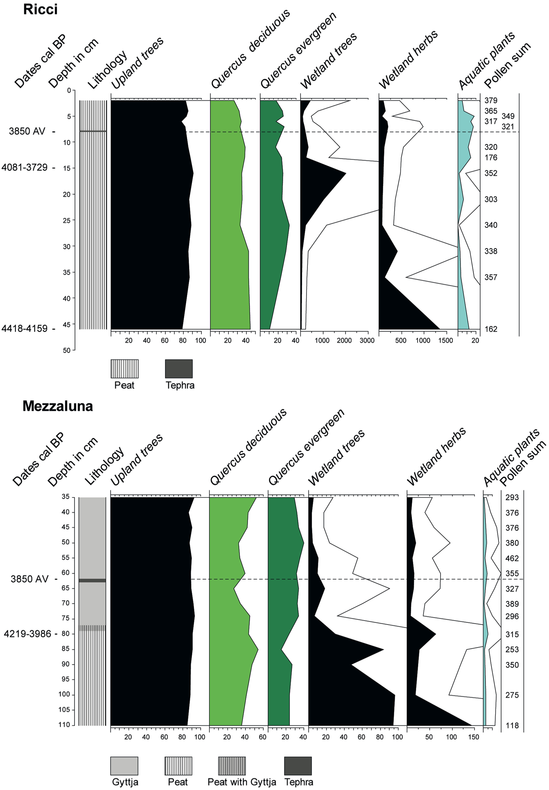
The Ricci and Mezzaluna pollen diagrams, shortened version. Exaggeration of the curves of Wetland trees, Wetland herbs, and Aquatic plants: 5x; the dotted horizontal line indicates the position of the AV tephra.
In Figure 7, the pollen sum upon which the percentages are based is a strict upland sum, excluding all pollen types that might have been released by a wetland or lake vegetation, including grasses. The wetland percentages based on this pollen sum reflect the local hydrological situation and are, therefore, important for the study of hydrological changes in the Pontine Marshes. The upland pollen percentages reflect eventual changes in the vegetation of the higher grounds.
At Ricci the series starts with wetland herbs and aquatics. Later, this vegetation is superseded by trees, in this case an alder carr. In its turn this carr disappears to make place for water plants. The changes are best interpreted as a local change in water level. After 4418-4159 cal yr BP (2468-2209 cal yr BCE) the locality becomes drier, to become wetter again after 4081-3729 cal yr BP (2131-1779 cal yr BCE), and before the deposition of the AV tephra. In the Mezzaluna section, a carr and marsh vegetation (wetland trees and herbs) including some shallow pools (aquatic plants) is replaced by aquatics only. This change is also reflected in a change in lithology: a change from peat to gyttja. This development takes place around 4219-3986 cal yr BP (2269-2036 cal yr BCE) and before the deposition of the AV tephra. It can only be understood as an increase in wetness.
Di Rita et al. (2018) studied the Holocene vegetation dynamics in this part of Italy in a wider context, based on a core from the Gulf of Gaeta. For the period 4750–4100 cal yr BP (2800-2150 cal yr BCE), they record an upland forest decline culminating around 4200 cal yr BP and mainly related to a decrease in evergreen Quercus (oak). After 4100 cal yr BP the forest recovered, reflected by an increase in evergreen and deciduous trees. The Ricci diagram displays slightly lower upland tree percentages in its lowest part, after which especially evergreen Quercus percentages gained importance. This matches the development reported by Di Rita et al. (2018) though to a lesser extent. The period recorded in the Mezzaluna diagram started presumably later but offered a similar development in the Quercus curves.
Di Rita et al. (2018) ascribed the development after 4100 cal yr BP (2150 cal yr BCE) to a change in climate towards wetter conditions. The agreement of the Ricci and Mezzaluna data with those of Di Rita et al. (2018), which reflect a much wider area, leads to the conclusion that the changes in hydrology observed in Ricci and Mezzaluna are not just a very local phenomenon, but of a more general nature and point at a climate change to wetter conditions. They may be applied to the entire Agro Pontino graben and led to a poorer drainage, reducing the agricultural suitability of the clayey soils in the lagoonal deposits of the Borgo Ermada complex. The various ditches can be placed in the context of a gradually wetter and drowning landscape, and most likely represent a first, but ultimately vain attempt to reduce drainage problems encountered by the local population during the Late Neolithic or Copper Age.
The Murillo drainage system
The Via Murillo starts in the NW upstream of Latina Scalo and runs towards the SE, ending at the Migliara 47. It is one of the surviving early (pre-bonifica) roads through the central plain and runs over a slightly higher ‘ridge’ that over large tracts follows the course of an early river and a later canalized stream baptized the Murillo River. This ridge forms one of the major ‘fingers’ of fluvio-colluvial sediment, extending into the wetland of the central plain (see Figures 2 and 8). This Murillo River was the major stream in the graben and has been traced in corings and excavations throughout the whole area depicted in Figure 8 (see e.g. Feiken, 2014). At the Migliara 47 the name of the road changes into the Strada del Tomarone, but the finger extends further SE to the Migliara 48 SX, where it stops. The Murillo deposits could be easily traced in corings by their specific colour (reddish brown, inherited from the soils from which this sediment was derived), texture (a coarse textured core – up to highly gravelly sands – bordered by loamy clay to clay), and composition (high in volcanic minerals), and rest on humic, commonly black pyritic Holocene clays, generally holding the AV tephra layer at a depth of 20–40 cm below the fluvio-colluvial deposit (Sevink et al., 2020). Typical examples are shown in Figure 8 (Ricci and Church).
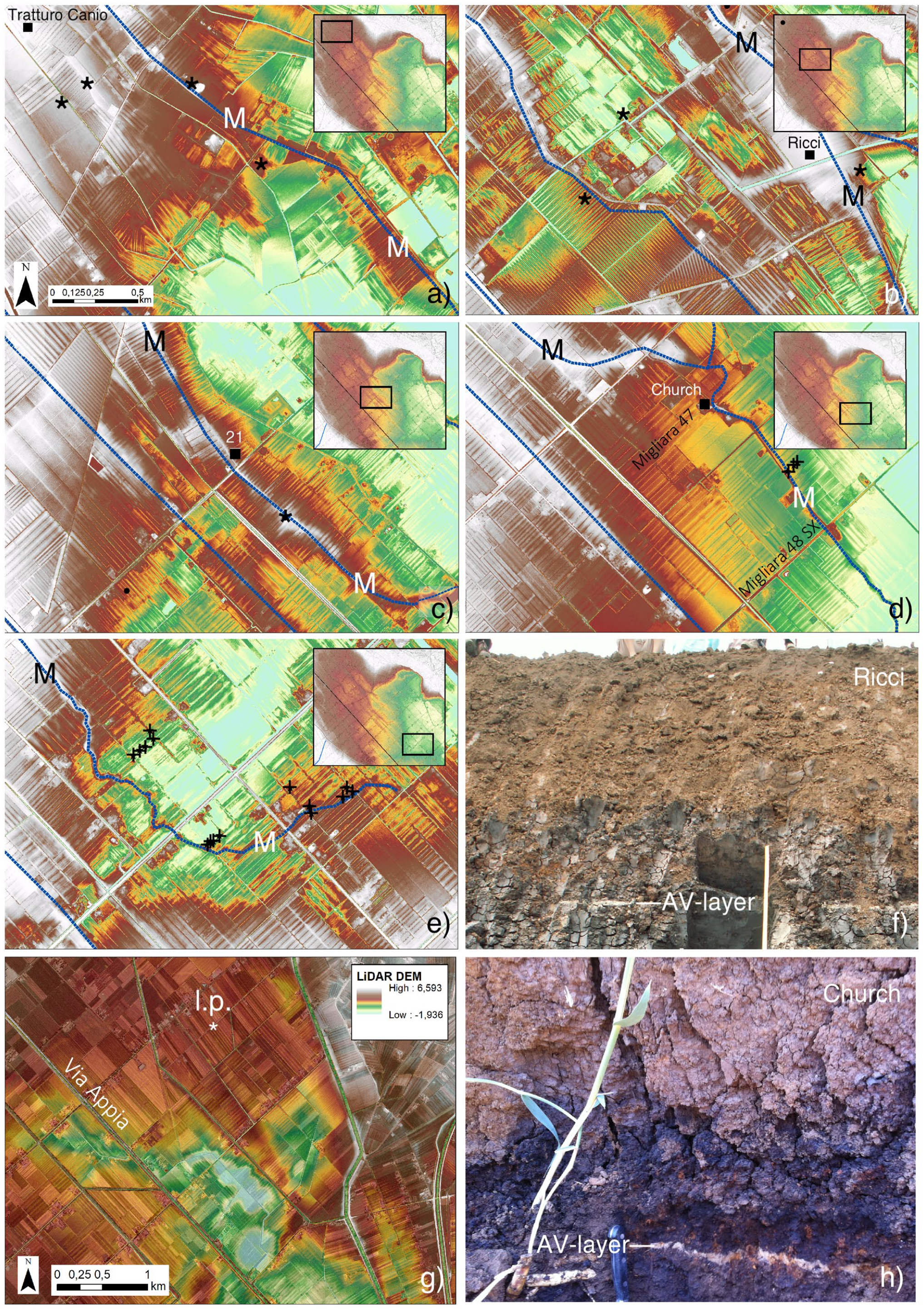
(a–e) The Murillo stream and road, and SE extension of its course (indicated as a black line and with M), 14C sample sites: Tratturo Caniò and 21 (see Table 1). (f) Ricci and (h) Church: sections with AV layer in pyritic black clay covered by reddish-brown fluvio-colluvial sediment. (g) Location of lowest point in Borgo Ermada level (l.p.). ∗ = Late fourth – second c BCE sites; ■ = Radiocarbon dating sites; += Coring locations. All maps in a-e have the same orientation and scale.
Feiken (2014) extensively described the northern part of this system, which was well exposed in the Tratturo Caniò excavation, while further to the SE it was exposed in the Ricci pit (Bakels et al., 2015). In the further SE extension of the system, later (unpublished) corings by the first author showed that the maximum thickness of the finger declines to about 1.5 m near the Migliara 47 and at its end, near the Migliara 48 SX, about 1 m. As at Ricci, the AV tephra layer and the fluvio-colluvial sediment continued to be separated by a few decimetres of marsh sediment. Whether more upstream (near Tratturo Caniò) or near its end (Migliara 48 SX), the earliest archaeological materials found in the top stratum date from the late fourth to third century BCE testifying to a major reduction of the sedimentation in that period (De Haas, 2017).
The earlier studies provide no information on the eventual extension of this Murillo system beyond the Migliara 48 SX and its eventual link with the La Cotarda outlet. The recent research showed that beyond the Migliara 48 SX no more finger of brown to reddish brown fluvio-colluvial material exists but on the detailed DTM a meandering streambed could be discerned that runs in eastern direction where it ultimately fades out. The recent corings confirmed that this indeed represents such stream with low levees. Core locations and descriptions can be found in Supplemental 1. The levees consist of reduced black organic silty clays, while the stream channel deposits consist of a coarser fill at the bottom, overlain by peaty sediment, which is often high in freshwater shells. Evidently, the sediment was deposited in a true wetland with permanently reduced conditions, providing a clear indication for the altitude of the water level at that time, which is c. 1 m asl.
In Table 1 an overview is given of the various 14C dates earlier obtained for organic materials from the top of the marsh deposits, immediately underneath the fluvio-colluvial deposits. They centre at around 1000-900 cal yr BCE, indicating that around that time the maximum level of the water or marsh in the inland area was reached. Such age is in line with the observations on the Casale Mazzocchio outlet, where the archaeological site was covered by a thin layer of more recent deposits and this outlet stopped functioning around that period (see 3.1).
More recent, pre-Roman outlets of the interior plain
The area in between the Casale Mazzocchio excavation and Mesa forms a low swell in the Borgo Ermada lagoonal plain, which separates the interior plain from the coastal area and acted as a divide between the two drainage systems. Unpublished results from the earlier corings performed in this area for the 1984 soil map (Sevink et al., 1984) were re-interpreted and altitudes were established using the now available LiDAR data. Results are that altitudes of the Borgo Ermada surface are 2 m asl. or even slightly higher, which is considerably above the maximum level of the outlet at Casale Mazzocchio (ca. 1 m asl.). However, a local low exists where the Borgo Ermada deposits occur at ca. 1 m asl., implying that here a new outlet will have formed once the blockade had proceeded till above this altitude. This very likely coincided with the end of the habitation at the Casale Mazzocchio site, that is, in the transitional period from the Final Bronze Age to the Iron Age. This potential outlet is indicated in Figure 8 with * (l.p. = lowest point) and currently is also filled to c. 2 m asl.
The Roman and later drainage conditions
In Roman Republican times (fourth/third centuries BCE) a drainage system existed with an overall N-S/E-W orientation of which the age has not yet been fully established (De Haas, 2017; Tol et al., 2021). Parts of this system may date back to pre-Roman times since N-S/E-W oriented drainages were found to have already existed in truly early times (see above). In this context, the identification in the LiDAR data of a large W-E oriented canal that runs towards the low in the divide mentioned above is truly interesting and calls for further research and dating of this feature. Whether continuity existed in this system from the Early Iron Age on or Romans modified a pre-existing natural drain thus still must be established.
Remarkably, in the recent Casale Mazzocchio archaeological test trenches an Early Roman canal was found, cut into the Borgo Ermada level but later filled in and no longer active in later Roman times (see Figure 4 and Supplemental 1). Whether the presumed outlet found by coring further south and the exposed canal at Mazzocchio belong to the same drainage system is not clear. However, both were blocked and filled in by the further aggrading Amaseno fan during later Roman times. Further south, no similar outlet has been found in the low divide in the Borgo Ermada lagoonal complex in this part of the plain and in all corings the surface of the Borgo Ermada complex was found at c. 2 m asl or higher (unpublished corings for the 1984 soil map, re-interpreted and altitudes based on recent LiDAR data). The only major and still active drains are the Decennovium and the Canale Schiazza, which both are clearly man-made, more recent Roman canals (see Figure 9). The construction of these canals thus can be linked to the increasingly problematic drainage of the interior graben due to the gradual expansion of the Amaseno fan, which blocked the early drainage system.
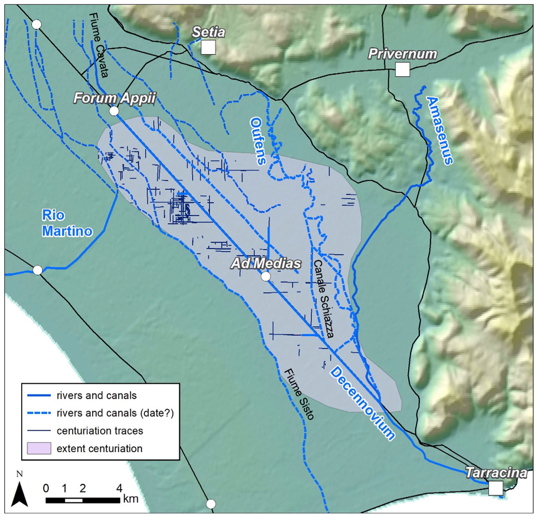
Identified traces of the Republican centuriation system and a reconstruction of possibly related main drainages arteries (solid lines are confirmed Roman, dotted lines unconfirmed). Names of major drainage canals that may be Roman in origin but were active later are in black.
General discussion
The observations described above can be placed in a wider context, being the relatively poor drainage of the lower parts of the Pontine plain during the Roman Republican period and the need to develop a more systematic and higher capacity drainage system of canals and ditches.
Firstly, from about 1000-900 BCE on (transition between Bronze Age and Early Iron Age) lower parts of the interior wetland were gradually raised through massive deposition of fluvio-colluvial sediments, which choked the natural drainage systems due to their excessive supply. In lower parts, where not reached by the sediment, peat continued to accumulate, also raising the land surface and groundwater level. This was particularly the case in the southern and eastern parts of the wetland, where isolated archaeological finds in the peat testified to its continued accumulation (Feiken, 2014). Secondly, sea level was still rising (e.g. Vacchi et al., 2021) and the Amaseno deltaic fan further aggraded and expanded (see e.g. Van Joolen, 2003), resulting in deterioration of the drainage of the interior wetland described in 4.2.2.
Initially, drainage of the higher parts of the inland basin and the fluvio-colluvial sheets and fingers will have been adequate for crop production. However, in between c. 350 and 50 BCE climate became less dry and relatively cool with rainy winters causing larger discharges (Di Rita et al., 2018; Margaritelli et al., 2020). This convergence of several developments very likely explains the inadequacy of the existing drainage systems and the need for a larger scale and systematic approach in the form of the major Roman reclamation works: the construction of the Via Appia, the Decennovium, and the associated drainage system, following the centuriation model (De Haas, 2017; Tol et al., 2021). Evidently, socio-economic and political factors also played a role in this centralized and large-scale reclamation and colonization of the Pontine area.
The resulting intensive drainage and land use inevitably set off soil subsidence in those parts of the Pontine Marshes where Holocene sediments were apt to subside by a combination of compaction and mineralization (peats), brought about by the improved drainage. Furthermore, sea level rise continued, though at a much slower pace as did the aggradation of the Amaseno fan (see Figure 3). In combination, this must have led to a continued lowering of the gradient in the drainage canals and to aggravating drainage problems. These are likely to have also aggravated in the somewhat higher parts of the plain by the end of this millennium (c. 50 BCE), because at that time climate became more humid (see Di Rita et al., 2018). The combined effects would well explain the declining agricultural settlement of the Pontine plain in the Imperial period, described by Walsh et al. (2014).
Since the major Roman reclamation works, the Pontine Marshes form a meta-stable system, where such works, aiming at improving the overall drainage situation, in the end must inevitably have led to soil subsidence and thus set-off a further deterioration of the drainage situation. Contrary, in periods of system breakdown, this subsidence will have slowed down. To this adds variations in climate, which were associated with changes in net precipitation and concurrent river discharges. Thus, since the large-scale reclamation in Roman Republican times, the overall situation is one of an entangled set of natural and anthropogenic processes, resulting in ups and downs in the drainage history which cannot be simply ascribed to an economic or social driving force, as has recently also been stressed by De Haas and Schepers (2022). Particularly important must have been the decline in sediment supply and peat growth, brought about by, respectively, the enhanced control over the run-off and discharge by the man-made drainage system, and the improvement of the drainage conditions in the plain by digging canals and ditches. Over time this must have resulted in a significant soil subsidence of major parts of the Pontine Marshes (see Serva and Brunamonte, 2007; Van Gorp et al., 2020), while at the same time sea level continued to rise, though at relatively slow pace.
The overall impact of this entangled set of processes, prior to the bonifica integrale, can be well judged from the map presented in Figure 10(1). This figure shows the extension of the area below sea level at the time of the bonifica, illustrating that permanent wetlands were largely restricted to the coastal zone, but also evidencing that the earlier drainage attempts had already resulted in a quite massive soil subsidence. Clearly, seasonal wetlands will have covered far larger areas, particularly further inland where seasonal flooding was a well-known phenomenon and was the main reason, for example, for the construction of the Canale delle Acque Alte. The map additionally shows the fan that was built up by the Amaseno upon its entering of the Pontine Marshes. The bonifica integrale, which was the first to employ hydraulic pumping stations, resulted in a much more massive and extensive soil subsidence which can be well judged by comparison of the maps 1 and 3, presented in Figure 10. It is particularly the significant and widespread lowering of the groundwater level that clearly induced a massive subsidence in areas underlain by Holocene predominantly peaty sediments. That the Amaseno fan hardly subsided can be easily explained by the early compaction of the Holocene sediment underneath the thick burden of fan deposits that developed already far before the bonifica integrale (see Supplemental 1 for details on this burden).
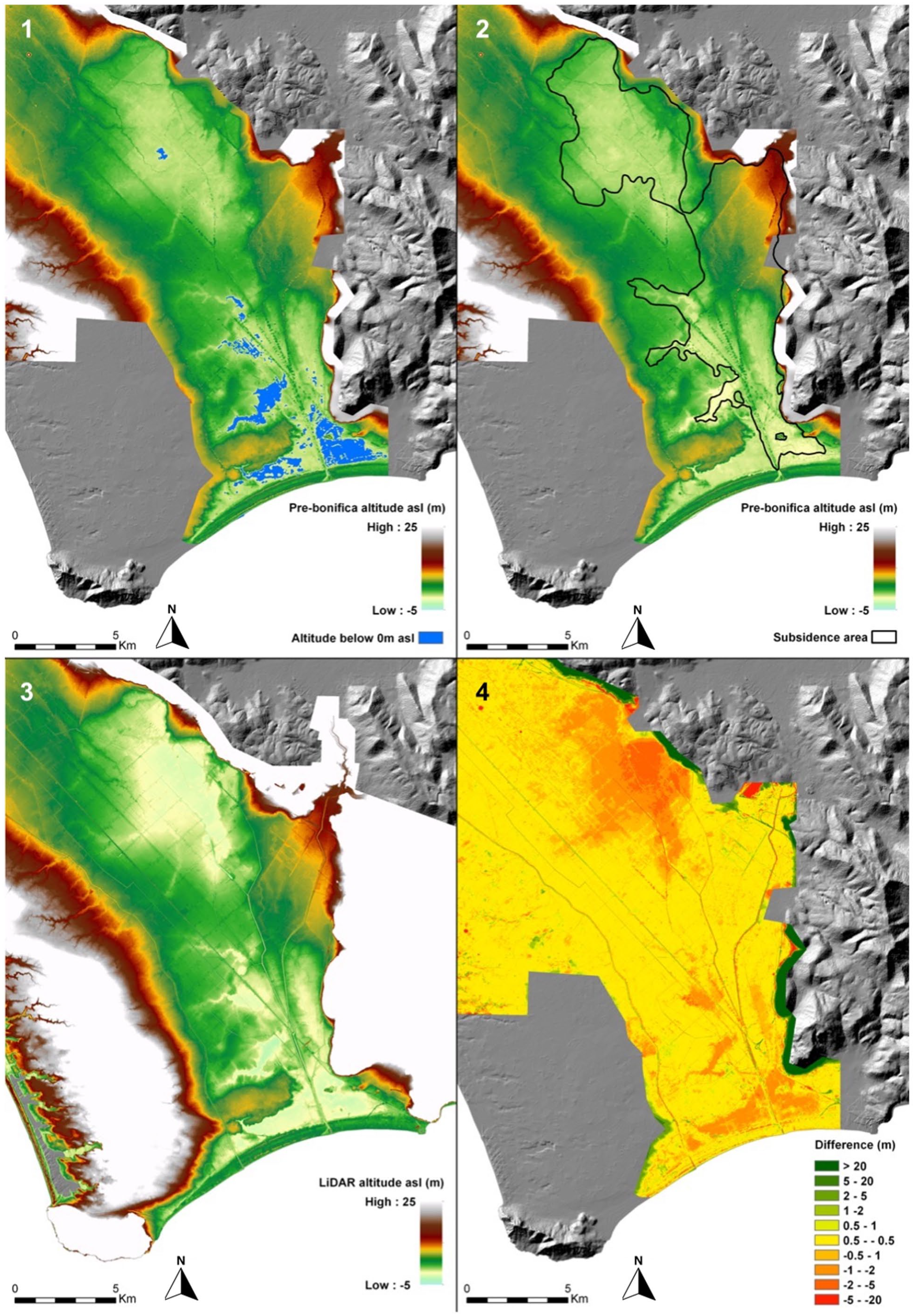
The impact of soil subsidence in the Pontine Marshes based on detailed topographic data. 1 = altitudes (1928) and area below 0 m asl; 2 = Pre-bonifica altitudes with delineated areas with ‘compactible Holocene sediments’; 3 = LiDAR based altitudes (2011); 4 = Soil subsidence based on comparison of 1 and 3. For technical details, see Van Gorp et al. (2020).
Synthesis of the history of the Pontine Marshes
Natural processes linked to sea level rise and climate governed the drainage history of the Pontine Marshes till the onset of the Iron Age (around 950 BCE). Particularly important were the built-up of the Amaseno deltaic fan due to the rising base level of this river. The fan dammed the river system draining the inland part of the Pontine Marshes and caused the formation of an extensive wetland. Early human attempts to improve the drainage of the gradually drowning inland area exist, but these will have had a very limited impact given the very limited dimensions of the drains. This early phase of land use – during the Late Neolithic to Early Bronze Age – may eventually be linked to a drier climatic phase rendering the dominantly clayey soils of the Borgo Ermada complex more suited for agriculture, while the wetter climatic phase that started around 2150 BCE and lasted till c. 950 BCE likely contributed to the deteriorating drainage status of these soils. Overall, this may well explain the low density of archaeological finds from this period in the Pontine Marshes that has been described in all archaeological surveys (see e.g. De Haas, 2011).
By the end of this wetter period, a fundamental change occurred: a significant input started of eroded soil material that can be linked to a major expansion of agriculture in the adjacent uplands and mountains and may have been enhanced by the more xeric, open vegetation that existed till c. 350 BCE. Under such climatic conditions, discharge will have become more torrential and in combination with the expansion of erosion-prone agricultural fields, could lead to such massive transport (Kosmas et al., 1997). This massive influx of eroded sediment further enhanced the development of the Amaseno fan and further hampered the drainage of the interior wetland. However, for the relatively higher parts of the Pontine Marshes impacts on the drainage will have been minor since overall climate was more xeric. This changed around c. 350 BCE when climate is assumed to have become less dry. It is in this period that socio-economic and political factors start to play a prominent role, and a more complex interplay between these factors induced the need for improved drainage and for the massive drainage and construction works that date from this period, amongst which the Via Appia, the Decennovium and the extensive drainage system.
These massive construction works completely changed the drainage of the Pontine Marshes and set-off a new process, which was the subsidence of areas with a subsoil that was sensitive to such process, notably the earlier deep fluvial incisions and coastal lagoons that during the earlier part of the Holocene were filled with mostly clays and peats, of which the deeper parts still consist of fully unripened sediment. It is from this phase on that soil subsidence became the major process, activated by any attempt to improve the drainage and requiring ever increasing efforts to maintain a drainage that allowed for continuation of the agricultural exploitation. An important step was set by the bonifica integrale, when modern drainage techniques were introduced, however, without fundamentally changing the dominant role of this subsidence and even further enhancing this process.
The Agro Pontino differs from many other Mediterranean coastal wetlands by the composition of the upper strata of the Holocene fill, which becomes evident when comparing its surficial geology with those of for example, the Po delta (e.g. Carminati and Martinelli, 2002), the Arno delta and connected more inland valley (e.g. Rossi et al., 2011), and the Tiber delta (Bellotti et al., 2018). Dominant lithologies that we found are peat and peaty heavy clay, both with a very limited degree of ripening, if not drained, leading to a situation in which enhanced mineralization of organic matter and physical ripening of these upper strata contribute significantly to the total soil subsidence (Van Gorp et al., 2020). In deltaic areas with a large input of fluvial sediment, which are the most common type of large coastal wetlands in the Mediterranean (e.g. Ebro, Rhone, Po and Nile deltas), siliciclastic loams and sands dominate the upper strata and the ripening processes mentioned evidently play a far lesser role.
The future of the Pontine Marshes
Currently, worldwide attention is paid to sea level rise as a major hazard threatening the future of low-lying coastal wetlands (Jelgersma et al., 1993; Slangen et al., 2012; Vellinga and Klein, 1993). For the Lazio coast of Italy, this is exemplified by the studies of Lambeck et al. (2011) and Deiana et al. (2021), which both focus on future sea level rise and the extent of flooding. However, both studies do not consider technical approaches to combat and prevent flooding, nor reckon with the role of subsidence, which may aggravate the hazards posed (see e.g. Jelgersma, 1996). Moreover, their assumptions regarding the tectonic stability of the Agro Pontino and nature of the Pleistocene lagoonal deposits surfacing in the Pontine Marshes, are incorrect (see Barbieri et al., 1999; Sevink et al., 2013; Van Gorp et al., 2020). The rare publications on subsidence in the Pontine Marshes (Serva and Brunamonte, 2007; Van Gorp et al., 2020) paid no attention to its relevance for future sea level rise and the associated flooding hazard.
The global history of our coastal lowlands shows that hazards posed by sea level rise will be mitigated by developing coastal defence systems and that the ensuing drainage problems in these lowlands will induce a development of their hydraulic drainage systems to an ever-increasing capacity. Examples of such development are known from many coastal and deltaic areas worldwide (e.g. Teatini et al., 2011; Törnqvist et al., 2008). A realistic prediction of the future of the Pontine Marshes for several scenarios of sea level rise should incorporate an estimation of the subsidence over the period considered in a specific scenario. Its potential magnitude can be derived from the historical data on the subsidence as produced by Van Gorp et al. (2020), combined with the detailed information on the surficial geology that was obtained in the various studies described above. Values for recent subsidence rates were found to be in the order of metres per century but were highly variable and depended on this surficial geology. This implies that such application requires a more in-depth consideration of the processes involved.
Soil subsidence is brought about by three basic processes, each of which need to be accounted for (Brain, 2015). These are a) compaction of sediment above the groundwater level due to physical ripening, b) chemical ripening of the sediment above the groundwater level of which mineralization of organic matter (e.g. peat) is particularly relevant, and c) compaction of sediment below the groundwater level due to the weight of the overlying burden. In the Pontine Marshes future subsidence will very much depend on the thickness and nature of still not ripened underlying Holocene sediments, given the already long history of processes mentioned under a) and b). Our estimates of future subsidence therefore concern those areas with ‘compactible Holocene sediments in their subsoil’, which we identified based on the coring data that we acquired between c. 1970 and 2022, and on the soil maps (see Figures 2 and 9). Lastly, we exclude tectonic subsidence for two reasons. First, there is no evidence at all for any significant tectonic subsidence to have taken place following on the development of the Borgo Ermada marine complex (MIS 5.3) and, second, at the time scale involved, its rate would be negligible relative to the rates of soil subsidence that we found in our analysis of the impact of drainage (see Figure 9(4)).
Estimates for rates of sea level rise are tentative and vary considerably, as is exemplified by the data presented by, for example, Sweet et al. (2017) and Antonioli et al. (2020). Using their data as reference, we produced two scenarios for which we assumed that in 2100 the local sea level will have ascended to 1 m asl and in 2200–2 m asl, respectively (see Figure 11). We assume that the soil subsidence over these periods will be equal to that over the past c. 80 years in 2100, and a double value of that subsidence in 2200, respectively. Rates in subsidence-prone areas can be expected to slightly slowdown in the future and the assumed values evidently should be seen as best approximates. The outcome of these two scenarios can be summarized as follows:
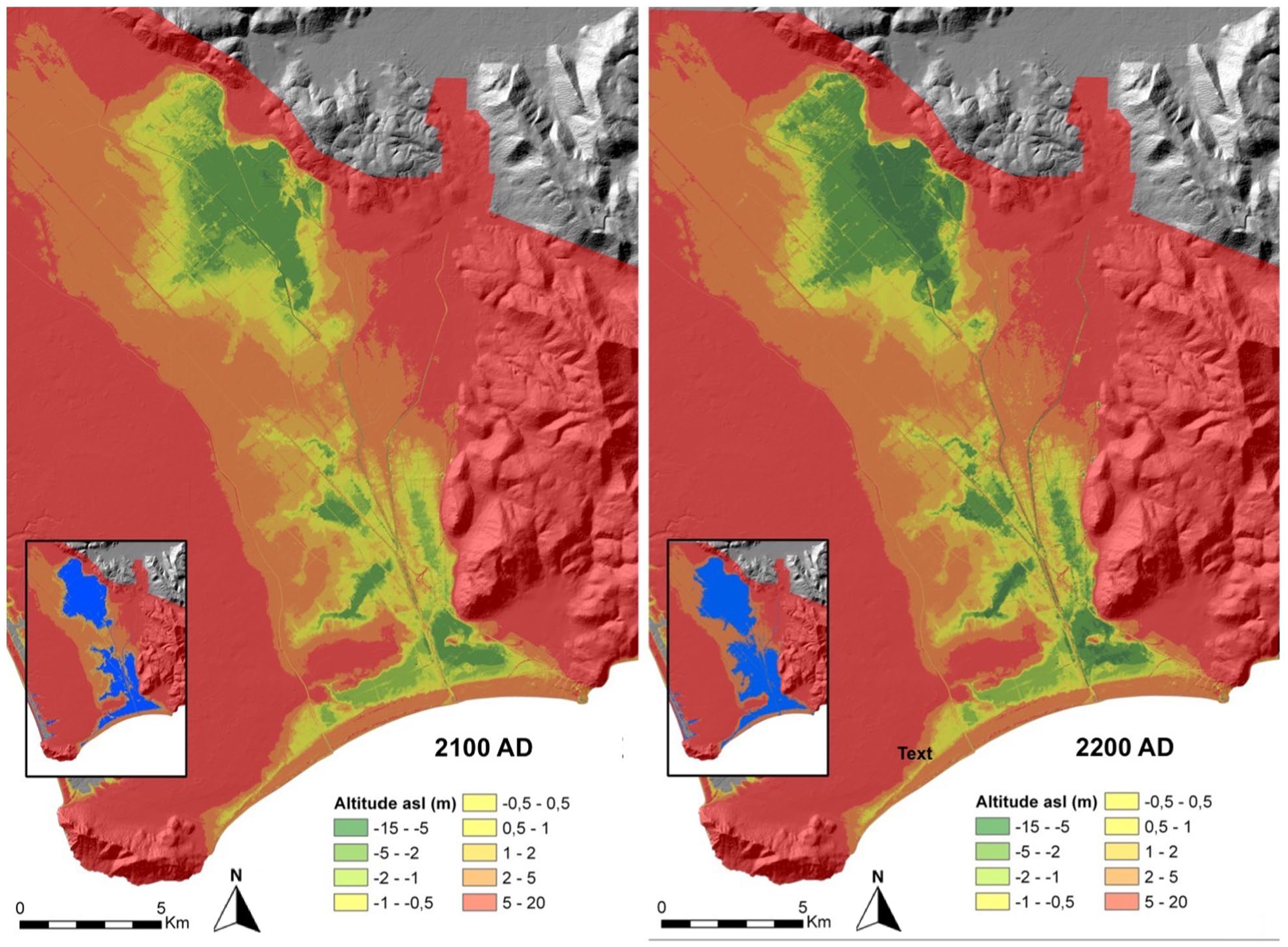
Scenarios (2100 and 2200 CE) for the impact on the Pontino Marshes of sea level rise (1 and 2 m, respectively) and soil subsidence, assuming continued drainage and land use. Areas below sea level are indicated in blue (see insets).
- Changes in altitude due to subsidence will further increase and reach such dimensions that they require a serious adaptation of the drainage system. Particularly in the inland area the situation may become truly problematic, with ground level altitudes as low as –10 m asl and even lower. Alternatives will have to be considered including flooding of the lowest areas and their transformation into wetlands. This would be in line with suggestions for re-wilding of coastal areas (e.g. Balbo et al., 2017).
- Though in part of the inland area serious drainage problems can be expected (see above), the development of an adequate defence system, with dikes and an increased pumping capacity, is feasible. This is mainly due to the dominance of low permeability Holocene and earlier sediments in the subsoil of the inland area where such dikes could be constructed – the narrow corridor between Borgo Hermada and the Monti Ausoni.
- Serious problems will be encountered in the Terracina coastal area, where future soil subsidence will be of relative minor importance because of the sandy subsoil (Holocene beach ridge sands, Sevink et al., 1984), but because of the high permeability of this subsoil seawater seepage will become a serious problem and may no longer be manageable.
Conclusions
In most existing studies on the history of the Pontine Marshes emphasis is on the political and socio-economic backgrounds of the ups and downs in its drainage and land use since the early Roman times. Our reconstruction of the Holocene history of the Pontine Marshes offers a different picture. Initially, the hydrology of the area was determined by natural processes, notably sea level rise and its impact on the existing natural drainage system, leading to the development of a large inland wetland, which formed the core of these Pontine Marshes. Attempts to combat the adverse conditions that resulted from this development date back to before the Early Bronze Age but clearly were in vain. Increasing and more intensive land use started around 1 ka BCE and induced a massive soil erosion in the adjacent mountains, the massive influx of this eroded material in the plain choking its drainage system.
The situation fundamentally changed in the early Roman Republican period with the development of an intricate drainage system and a sharp decline in the supply of eroded soil material. This artificial drainage most probably was the first serious trigger for the soil subsidence that continues till today. Combined with ongoing sea level rise this subsidence led to an increasingly problematic drainage, with in addition can be partly linked to unfavourable climatic conditions that existed later in the Roman period (after c. 50 BCE). Drainage problems were very hard to overcome by the pre-modern drainage techniques and thus its drainage history showed many ups and downs. It was only a bonifica integrale that could solve the problems but in view of the current sea level rise, this success should be seen as temporary. This is evidenced by the scenarios for the next few hundred years, which are based on the expected sea level rise and past subsidence rate, under a continued drainage and land use regime.
The quantification of the expected subsidence was possible due to the unique existence of a topographic data set that was obtained for the bonifica integrale which could be compared with a recent LiDAR-based DTM, in combination with detailed insight into the surficial geology of the area. The scenarios are seen as far more realistic and relevant for politicians and planners than scenarios based on long-term sea level rise and digital terrain models only, such as those by Lambeck et al. (2011) and Deiana et al. (2021). Our approach is more in line with that of studies aiming at assessment of the impact of sea level rise over relatively short periods of time, such as that for the coastal plains in Campania by Di Paola et al. (2021).
Supplemental Material
sj-docx-1-hol-10.1177_09596836231176495 – Supplemental material for The Pontine Marshes: An integrated study of the origin, history, and future of a famous coastal wetland in Central Italy
Supplemental material, sj-docx-1-hol-10.1177_09596836231176495 for The Pontine Marshes: An integrated study of the origin, history, and future of a famous coastal wetland in Central Italy by Jan Sevink, Tymon CA de Haas, Luca Alessandri, Corrie C Bakels and Francesco Di Mario in The Holocene
Footnotes
Acknowledgements
We are indebted to numerous colleagues who in the past have been involved in the study of the Pontine Marshes. Amongst these we want to specifically mention Arie Remmelzwaal and Paul Schenk (both UvA), and in later years Peter Attema, Ester van Joolen, Rik Feiken, Marieke Doorenbosch, Gijs Tol and, with emphasis, Wouter van Gorp. We are seriously indebted to these colleagues for their important contributions to the study of the geology and history of the Pontine Marshes. Thanks are also due to the team of archaeologists that was involved in the Casale Mazzocchio project, notably Diego Blanco, Leonardo Crisci, Alessia Savi Scarponi, Francesco Visco, Gianluca Melandri, and, finally, Carmela Anastasia who since long aids us in our studies. Martijn van Leusen is acknowledged for his support in the analysis of the topographic data. Lastly, we acknowledge four anonymous reviewers for their constructive comments.
Funding
The author(s) disclosed receipt of the following financial support for the research, authorship, and/or publication of this article: Over the past years the studies of which the results are described above were funded by many organisations, amongst which the Dutch Universities of Amsterdam, Groningen and Leiden, and The Netherlands Organisation for Scientific Research (NWO). The latter in the form of the Free Competition grant 360-61-060 (Avellino Project). Lastly, the LUF-Byvanck and Chatelain Nobach Funds generously gave financial support for the coring campaigns in 2019 and 2021 in the Pontinia and Mesa areas.
Supplemental material
Supplemental material for this article is available online.
References
Supplementary Material
Please find the following supplemental material available below.
For Open Access articles published under a Creative Commons License, all supplemental material carries the same license as the article it is associated with.
For non-Open Access articles published, all supplemental material carries a non-exclusive license, and permission requests for re-use of supplemental material or any part of supplemental material shall be sent directly to the copyright owner as specified in the copyright notice associated with the article.