
Abstract
The drivers of fire regimes prior to the European occupation of Australia are still contentious, with some advocating regimes dominated by anthropogenic ignitions and others advocating a climate source or mixture of these elements. Here, we examine an 850-year history of fire regimes at Lake Werri Berri in south-east Australia, prior to and following European occupation. Macroscopic charcoal and FTIR spectroscopy were used to infer broad changes of the fire regime in proximity to the lake. We found little change through much of the 850-year period and most interesting, no apparent change following the initial displacement of Indigenous peoples and the introduction of farming and woodcutting to the region by Europeans. From the mid-20th Century onwards, there was an increase in both area burnt and fire severity or intensity, likely the result of increased fuel load and connectivity following an extended period of increased precipitation and heavier recreational land usage, which likely led to an increase in anthropogenic ignitions.
Introduction
Humans have impacted most of Earth’s terrestrial landscapes in various ways for millennia (Ellis et al., 2021) and it is undoubtedly true that Indigenous people in Australia occupied fire impacted terrestrial environments (e.g. Mooney et al., 2012; Rule et al., 2012; van der Kaars et al., 2017). Several studies have argued that the Indigenous peoples of Australia strategically used low intensity, frequent application of fire to create a ‘cultural landscape’ (Bliege Bird et al., 2008; Bowman, 1998; Head, 1989). This method of fire management has been associated with distinct changes in the environment, including levels of biomass consumption that were lower than what would today be considered ‘normal’ (Fletcher et al., 2021a, 2021b) and that the cessation of these practices has contributed to catastrophic contemporary bushfires (Mariani et al., 2022). Mooney et al. (2011), however, showed in a large meta-analysis of charcoal records in Australia that fire regimes are predominantly affected by climate, with no broad scale changes to fire regimes following the arrival of humans. Williams et al. (2015a, 2015b, 2015c) examined Indigenous population indices alongside fire regimes and found no clear relationship between biomass burning and Indigenous people in temperate Australia. It should be noted, however, that synthesis studies tend to reflect regional-scale fire regimes and underrepresent information at the local-scale.
In Australia, bushfire weather is determined by season and occurs at different times of the year depending on area, though local conditions may cause wildfires in any season (BOM, 2021b). In general, fire regimes tend to correspond to a north-south gradient of summer-winter rainfall activity brought on by the Australian latitudinal gradient of summer monsoonal rainfall (Murphy et al., 2013). Murphy et al. (2013) describe a pattern of frequent, low intensity fires in the monsoonal north, and infrequent, high intensity fires in the south. In temperate eastern Australia, drought and ambient weather act interdependently to create conditions for large scale fires to occur.
Analysis of past fire regimes in Australia has focused on the use of charcoal particles preserved within sedimentary archives. Extraction of these charcoal particles has relied on the use of light oxidants to extract charcoal from sediments, a process Constantine and Mooney (2022) have recently demonstrated can preferentially remove the less recalcitrant charcoal fraction produced at lower temperatures (e.g. low severity or intensity wildfires). This has potentially led to a bias towards larger, and more intense fires events and may have excluded many of the low intensity (low temperature) anthropogenic ignitions.
This study describes a ~850-year fire history of Lake Werri Berri, one of five lakes within the Thirlmere Lakes National Park (TLNP) in New South Wales, Australia. Research on various aspects of the vegetation, depositional environment, and fire history of TLNP has previously been conducted (Black et al., 2006; Constantine et al., 2021; Forbes et al., 2021; Rose and Martin, 2007). The aim of this research was to produce a record of fire occurrence from Lake Werri Berri to examine changes in the fire regimes of the region through the last millennium. This work examines the transition from Indigenous custodianship of the landscape to that of European management following their late 18th Century arrival to better understand how land use change affects fire regimes at this site, and more broadly, southeast Australia.
In this study we examine the fire history of Lake Werri Berri by applying charcoal analysis methods that extract charcoal with non-destructive means (e.g. without an oxidant) and a new method of characterising fire severity or intensity using FTIR spectroscopy (Constantine et al., 2021). The addition of FTIR spectroscopy in modelling past fire severity or intensity potentially provides useful insight into the characteristics of past fires in vicinity to the lake. In particular, we were interested in the question of whether there were noticeable changes to the fire regime following the displacement of Indigenous people from the area and the increased land use by Europeans beginning in the late 18th Century.
Site description
Lake Werri Berri (−34° 13′54.99″, 150° 32′20″, Figure 1), located ~90 km south-west of Sydney, is one of a series of five interconnected lakes within Thirlmere Lakes National Park (TLNP), itself a part of the Greater Blue Mountains World Heritage Area (UNESCO, 2000). The five lakes of TLNP occur at an altitude of approximately 305 m asl, with surrounding sandstone ridges rising approximately 100 m above the lake surfaces (Timms, 1995). TLNP is located in the south of the Sydney Basin, which is geologically a Permo-Triassic sedimentary basin and a distinct biogeographic region defined under the Interim Biogeographic Regionalisation for Australia (IBRA, 2012). The ephemeral wetlands of TLNP occur within an alluvium-filled incised meander that forms a distinct U-shaped pattern cut into the Hawkesbury Sandstone dominated catchment (Horsfall et al., 1988).
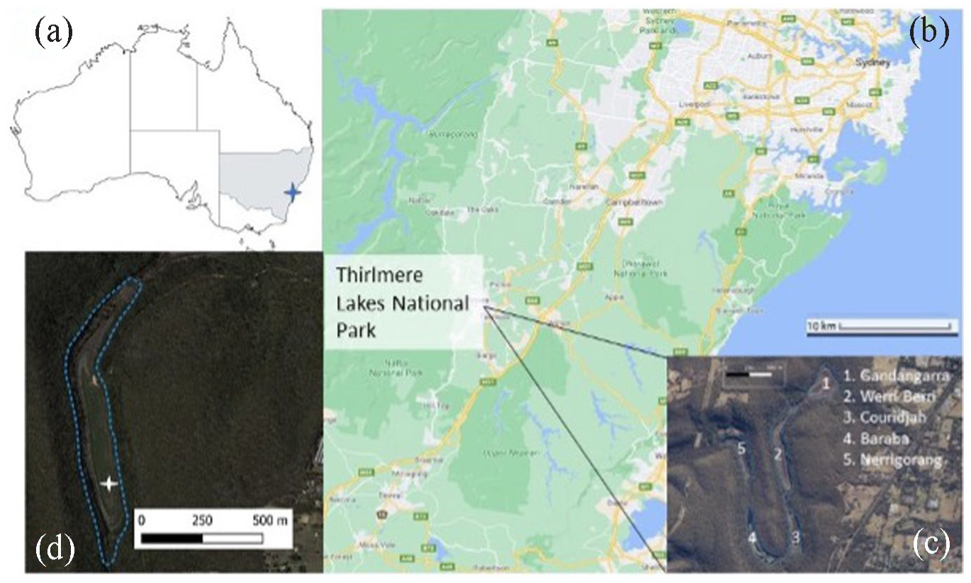
Location of Lake Werri Berri (d) in relation to the Thirlmere Lakes National Park (c), Sydney metropolitan area (b) (Google Maps, 2022) and the Australian continent (New South Wales is shaded) (a). The white star (d) marks the location where WB3 was cored.
Lake Werri Berri is an ephemeral lake with variable water levels (Horsfall et al., 1988). Water levels in the Thirlmere Lakes are influenced by both rainfall and groundwater (Pells and Pells, 2016; Schädler and Kingsford, 2014. In contemporary times, water levels in the lake have been primarily affected by climate (Banerjee et al., 2016), but also potentially by mining, agriculture, and water extraction (Pells and Pells, 2016; Schädler and Kingsford, 2014) which has led to periodic wetting and drying in the lakes (Banerjee et al., 2016). Each lake is self-draining, but during high water periods they may overflow the sill banks at their respective boundaries into the other lakes. However, outside of high-rainfall events, the lakes mostly accumulate sediment independently (Forbes et al., 2021).
The contemporary climate of the Sydney Basin is mild, warm, and temperate, with no distinct wet season (Climate-Data.org, 2020), though it does tend to rain slightly more in the summer months (December-February). Climate in the Sydney Basin is controlled primarily by the movements of the subtropical high-pressure belt, with rainfall mainly caused by the seasonal meridional movement of frontal systems between these high-pressure cells (Mooney et al., 2021). It is influenced by synoptic interannual variability of the Southern Annular Mode (SAM), El Niño Southern Oscillation (ENSO) and the Indian Ocean Dipole (IOD) (BOM, 2021a). ENSO has relatively little influence on the Sydney Basin, with El Niño periods corresponding with slightly reduced rainfall away from the coasts, and La Niña events corresponding with slightly increased rainfall. A negative SAM can result in drier conditions in the Sydney Basin as the result of warmer air being drawn from inland. In contrast, a negative IOD phase can bring more moisture to the region (Mooney et al., 2021).
Mean rainfall in the Sydney Basin varies considerably but tends to decrease with distance from the coast and increases with elevation (Commonwealth of Australia, 2019). At Picton, NSW (7 km to the northeast of TLNP), the average maximum and minimum summer temperatures are 29.3°C and 15.4°C, respectively and the maximum and minimum mean winter temperatures are 16.8°C and 1.7°C (Figure 2). Annual precipitation averages 800 mm, with an average of 118 days of rainfall per year (BOM, 2020).
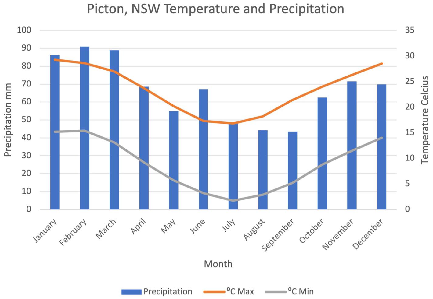
Monthly minimum and maximum temperatures (lines) and average monthly precipitation (bars) data from Picton (ID 068052), NSW, the nearest weather station (7 km to the northeast) to Thirlmere Lakes National Park (BOM, 2020). There is no distinct wet season in the Sydney Basin region, however, the summer months (December to February) tend to receive more precipitation than winter months (June to August).
The vegetation surrounding Lake Werri Berri is typical of the Sydney Sandstone Complex and has been described previously (Black et al., 2006; Forbes et al., 2021; Rose and Martin, 2007). The catchment surrounding the lake is characterised by high species diversity, with surrounding slopes and flats populated with dry sclerophyll forests and woodlands of mixed Eucalyptus species (including E. piperita, E. resinifera, E. elata, E. parramattensis), Corymbia gummifera and Angophora floribunda, with Acacia penninervis and Banksia serrata common on the flatter areas above the lake margins. Flax-leaf Paperbark (Melaleuca linariifolia) is common on the sandy intersills between the lakes. The understorey is species-rich and relatively open in structure and includes Banksia species, Acacia longifolia, Hibbertia diffusa, Dillwynia parvifolia, Xylomelum pyriform, Viminaria juncea and the fern Histoperis incisa. The lakes themselves show a zonation associated with water depth, with a shoreline dominated by dense rushes and sedges: Lepidosperma longitudinale, Lepironia articulata and Eleocharis sphacelata. The open water, when present, also includes Brasebia schreberi and Gonocarpus micranthus and other herbs are common on the lakebed or lake margins when it is dry.
The fire regime at Lake Werri Berri remained stable through much of the 20th Century before increasing substantially from the early 1980s (Figure 6). The National Parks and Wildlife (NPWS) fire history database (NPWS, 2021) recorded eight fires in the vicinity of Thirlmere Lakes since record keeping began in the 1960s. This included fires in 1965, 1969, 1982, 1988, 1998, 2005 and 2006. There are no records of fire events in the area prior to 1965, though it seems probable other fires occurred during the historic period but were not recorded.
The people of Thirlmere Lakes region
The Thirlmere Lakes region has a long record of occupation by Indigenous people prior to 1788 and the region was occupied by European settlers soon after their arrival in Australia. The D’harawal and Gandangarra people were the original inhabitants of the Thirlmere Lakes region prior to European settlement (Liston, 2011). People speaking the D’harawal language were thought to occupy a region stretching from the northern boundary of Botany Bay to the Shoalhaven River in the south, and as far inland as Camden (Liston, 2011). The D’harawal people are believed to have lived in an area encompassing the coastal regions and inland, while the Gandangarra people inhabited land including the more elevated sections of the Sydney Basin to the west (Stokes, 2015). Evidence suggests that people living closer to the sea generally took advantage of coastal resources and left shell middens, whereas ‘freshwater’ people, living further inland, were more reliant on possums and other small animals as well as harvesting tubers (referred to as ‘yams’ by European settlers) (Murray and White, 1988; Sahukar et al., 2003).
It has been relatively difficult to ascertain the social structure of the D’harawal and other groups in the area due to the collapse of social cohesion following European occupation and exposure to new diseases, which, including the outbreak of smallpox in 1789, is thought to have killed nearly half of the population (Organ, 1990; Stokes, 2015). Equally opaque is the likely population of pre-colonial people. In October 1795, Matthew Everingham attempted to cross the Blue Mountains from the lower Blue Mountains towards the east. Although this description comes from further north than the study area, the Cumberland Plain extends to the Thirlmere region in the south where he described witnessing thousands of fires throughout the landscape. (Gapps, 2018) argued that Everingham had witnessed ‘thousands of Aboriginal people living on their traditional lands’ including the Dhurag and D’harawal people to the south of his location, and the fires of Gandangarra families in the more elevated region beyond Camden (‘Cowpastures’).
European occupation and displacement of Indigenous peoples
European occupation of Australia is generally accepted to have begun in 1788 and the Thirlmere Lakes region was first described soon after, in 1798, when John Wilson ‘crosst three deep vallies with large ponds of water in each of the vallies’ (Fairley, 1978). Settlement of the Thirlmere Lakes region began in the early 18th Century, and this suggests that local groups of Indigenous people were among the first in Australia to encounter European settlers. In 1795, it was discovered that escaped cattle brought to Australia aboard the First Fleet had migrated to an area that would come to be known as ‘Cowpastures’, encompassing Camden County, an area 21.5 km to the northeast of Thirlmere. The territory was seized from the Indigenous inhabitants and land grants were issued to European settlers (Willis, 2018).
The early European movement into the region encountered considerable resistance by Indigenous people, and in some cases, this was attributed to people from out of the area, including ‘mountain natives’, likely Gandangarra people (Gapps, 2018). This resistance includes, infamously, a series of events that concluded with the Appin massacre on the 17th of April 1816 (~27 km to the northeast of Thirlmere): raids on district and outlying farms by Gandangarra people started in 1814, perhaps related to drought (Gapps, 2018). The massacre itself likely involved both Gandangara and D’harawal people, and arguably, effectively ended the traditional lifestyle of Indigenous people in the Thirlmere district.
European settlement accelerated in the district from the 1830s onwards (Enright and Thomas, 2008) when The Oaks, to the north of Thirlmere, was settled for dairy and wheat farming. In the mid-19th Century, the lakes were known as ‘Couridjah Lagoons’, which was believed to be an Indigenous word meaning either ‘where Banksia grow’ or the nectar from Banksia (NPWS, 2019).
In the latter half of the 19th Century, the lakes were investigated as a water supply for Sydney and a pumping station was built near Lake Couridjah for the newly built rail line which connected the area with Sydney (NPWS, 2019). Despite its use as a water source and for recreation, the catchment of Lake Werri Berri does not appear to have experienced any agricultural activity, perhaps due to the relatively unproductive sandstone soils and small catchment area. In the 1950s the lakes became known as Thirlmere Lakes and were subsequently turned into a State, then National Park (Fairley, 1978). During the 1950s, Lakes Gandangarra, Couridjah and Werri Berri were connected by a channel, and in the 1960s the lakes were used for powerboating and water skiing and stocked with trout for fishing (Horsfall et al., 1988). Today, most visitors to the park frequent the picnic areas around Lake Couridjah and Werri Berri (NPWS, 2019).
Methodology
In June 2019, a series of monolith cores (n = 3) were taken using a spade from exposed surface peats at Lake Werri Berri. The Lake Werri Berri monoliths were sampled at locations where longer sediment cores had previously been collected (as part of the NSW Office of Environment and Heritage Thirlmere Lakes Research Programme ‘Thirlmere Lakes: the geomorphology, sub-surface characteristics and long-term perspectives on lake-filling and drying’. That work resulted in the collection of a long sediment core WB1, on which only preliminary work has been completed (Cadd et al., 2022; Sherborne-Higgins, 2019). The monoliths used herein were sampled during a low water period when the lakebed was dry and large cracks had developed in the surface of the sediment. The monoliths were sampled to avoid any of these cracks to limit the possibility of contamination.
The longest monolith section (hereafter referred to as WB3), which was 22 cm long, was chosen for analysis and was described using a modified version of the Troels-Smith method (Kershaw, 1997). Bulk density was estimated by weighing a known volume of samples prior to and after oven drying (24 h at 105°C in a fan-forced oven). The samples were then placed in a muffle furnace for an additional 4 h at 550°C to determine loss on ignition (LOI) and the organic content was expressed as the percentage loss in mass per gramme of oven-dried sediment. Using the depth-age relationship detailed below, the flux of organic and inorganic components as g/cm2/year into WB3 was calculated.
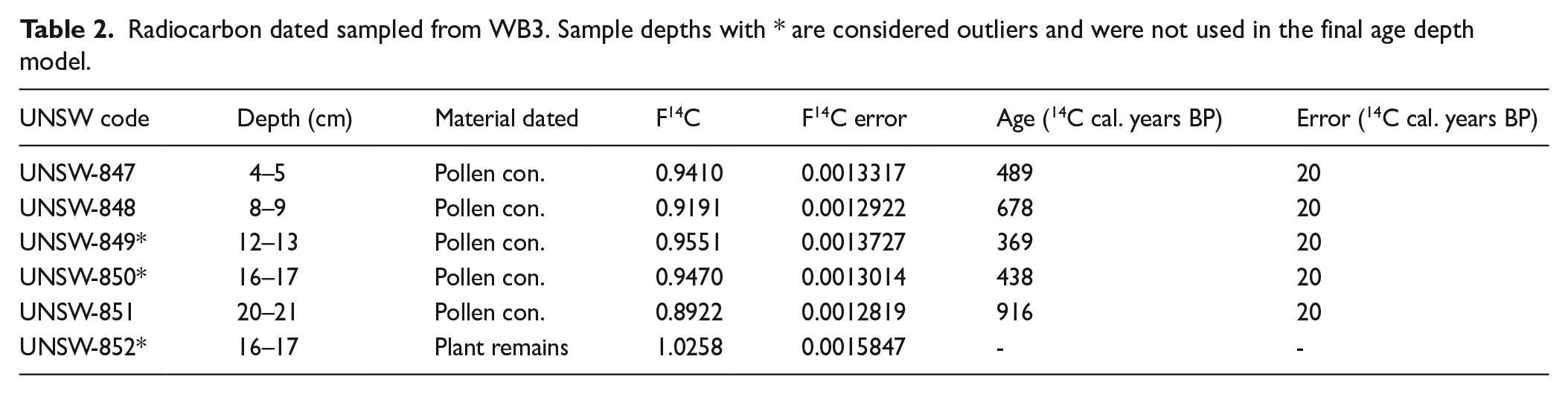
A Bayesian chronology for WB3 was constructed from radiocarbon and lead-210 dates using the R package rplum (Aquino-López et al., 2018; Blaauw et al., 2021). Five bulk sediment samples (taken from 1 cm depth intervals) were submitted to the Chronos 14 Carbon-Cycle Facility at the University of New South Wales for 14C dating by Accelerator Mass Spectrometry (AMS) (Turney et al., 2021). Pollen concentrates (n = 5) were extracted from the bulk sediment samples using the methods outlined in Cadd et al. (2022). During the initial sieving an elongated ‘grass-like’ fragment (n = 1) was recovered and treated using the standard acid-base-acid treatment outlined in Turney et al. (2021). In addition, eight bulk sediment samples from contiguous 1.5 cm (depth) samples (0–12 cm) were submitted to the Australia Nuclear Science and Technology Organisation (ANSTO) for 210Pb dating. Lead-210 was analysed by alpha spectrometry.
Charcoal analysis using ‘macrocharcoal’ (>250 µm) was performed contiguously at 1 cm intervals in order to characterise fire occurrence within ≈101–103 m of the lake (Clark, 1988). To minimise the influence of an oxidant, charcoal was separated from sediment using two methods: immersion in reverse osmosis H2O for 24 h and immersion in 4% NaOCl for 6 h, and the results were combined. The 250 µm size fraction was isolated by wet sieving (Long et al., 1998) and placed in glass petri dishes where extraneous material was removed manually. Charcoal samples were photographed, and the charcoal particles analysed for area and count using the image processing software programme ImageJ version 1.52a (Rueden et al., 2017). The combined concentration of charcoal from both methods, expressed as area (mm2/cm3), was then converted to the charcoal accumulation rate (CHAR) (Long et al., 1998; Whitlock and Millspaugh, 1996) by dividing charcoal concentration by the mean deposition time estimated from the age depth model.
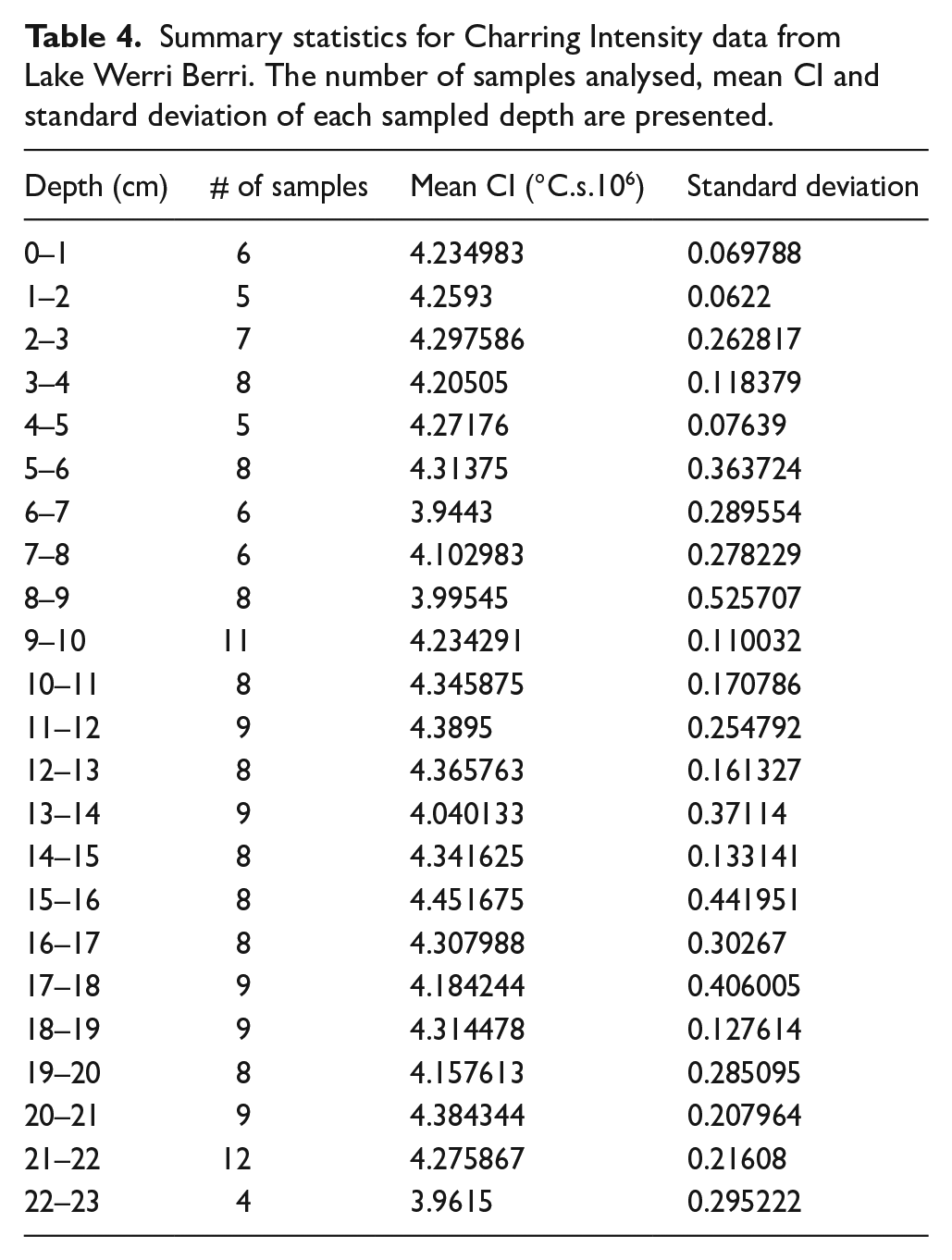
A novel method using Fourier transformed infra-red spectroscopy (FTIR) was conducted on separated charcoal fragments from each sediment layer to examine the intensity or severity of past fires at Lake Werri Berri. Macroscopic charcoal particles (1–8 per sampled depth where charcoal was present) were scanned using a PerkinsElmer ATF-FTIR spectrometer. Spectra were measured at 4000–650/cm wavenumbers at 4/cm resolution with a wavenumber spacing of 1, with four scans accumulated per sample. Data were baseline corrected with the R package ‘baseline’ version 1.2-1 (Liland et al., 2010, 2015) using the Modified Polynomial Fit function (Lieber and Mahadevan-Jansen, 2003). Charring Intensity, an indicator of the heat influx that produced the charcoal, and hence an indicator of the intensity or severity of the fire that produced it, was modelled from the FTIR spectra using the PLS calibration developed in Constantine et al. (2021).
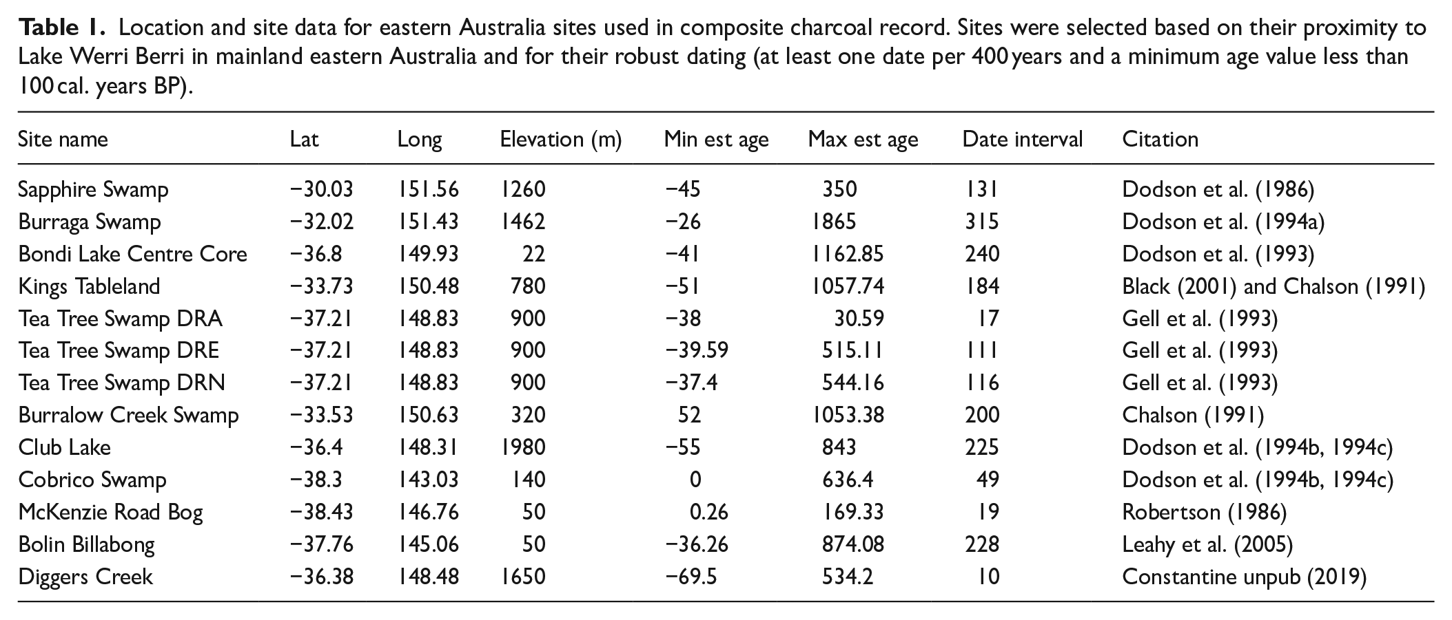
A 850-year composite record of select sites in eastern and south-eastern Australia (−39 to −29°S, 154–141°E, n = 13) was produced using the R package Paleofire (Blarquez et al., 2014) following methods described in Power et al. (2008). Sites (Table 1) were included based on their proximity to the study site (mainland south-eastern Australia) and only if they had a robust chronology (including at least one radiometric age (14C or 210Pb date) per 400 years and had age values encompassing the past 100 years). It should be noted that the composite charcoal record derived herein included data where charcoal was extracted using oxidant treatments, and thus may carry a partial bias towards higher intensity fires (Constantine and Mooney, 2022).
Location and site data for eastern Australia sites used in composite charcoal record. Sites were selected based on their proximity to Lake Werri Berri in mainland eastern Australia and for their robust dating (at least one date per 400 years and a minimum age value less than 100 cal. years BP).
A temperature reconstruction of warm season (September-February) land and ocean records (Gergis et al., 2016) was used to examine changes in southeast Australian temperature over the past millennia. To compare this to the Werri Berri charcoal data and to distinguish trends, a smoothing window (50-year rolling mean) was applied to the principal component regression (PCR) of this dataset.
A reconstruction of the trends in recent sea surface temperatures (SST) for southern Australia was derived from the NOAA ERSST v5 gridded dataset (Huang et al., 2021). A 10-year rolling mean smoothing window was applied to this dataset. An annual composite temperature anomaly (AD 1900–2020) (BOM, 2021c) and rainfall (BOM, 2021b), compiled by the Australian Bureau of Meteorology is also used. This dataset is constructed from a 30-year trend (1961–1990) of recorded temperature and precipitation data from land-based weather stations located in the coastal regions of New South Wales, Victoria, Tasmania, and eastern South Australia. Data were smoothed using a 10-year rolling mean.
A 1000-year record of ENSO based on the North American Drought Atlas by Li et al. (2011) was used to consider El Niño Southern Oscillation (ENSO) intensity. Significant events (<0.5°C, >0.5°C) were extracted to facilitate identification of trends and data was smoothed using a 10-year rolling mean. A 500-year record of drought intensity based on tree ring records compiled in the Australian New Zealand Drought Atlas (ANZDA) (Palmer et al., 2015) was also used to consider moisture availability in the environment. A 25-year smoothing window using a rolling mean was applied to the data to facilitate identification of drier and wetter periods.
Results
A mixed age depth model for WB3 was produced using the modelling software rplum (Blaauw et al., 2021) from 14C and 210Pb dated samples (see Tables 2 and 3) and is presented in Figure 3. Unsupported 210Pb results did not exhibit a decreasing profile below 4 cm, possibly the result of a fast accumulation rate. The ‘grass-like’ plant macrofossil at 16 cm was identified as likely being root material as it produced a modern age and was therefore excluded from the age-depth model. The deepest dated sample in WB3 (20–21 cm) suggested a basal age of 916 ± 12 calibrated years before present (cal. years BP) (where present (0 cal. years BP) represents CE 1950). The modelled age-depth relationship suggested a mean age of 865 cal. years BP at the 22 cm base, and an average temporal resolution of 42.5 years per centimetre (over the entire sequence). The two pollen concentrate ages from the surrounding sediments (12 and 16 cm) did not follow the observed stratigraphic sequence and returned ages younger than predicted from the age-depth relationship. The presence of macrophyte root material in proximity to these samples suggests potential for sediment mixing and penetration of younger pollen or other organic material into these layers. These samples were considered outliers by the Bayesian age-depth model and not included in the final model iterations.
Radiocarbon dated sampled from WB3. Sample depths with * are considered outliers and were not used in the final age depth model.
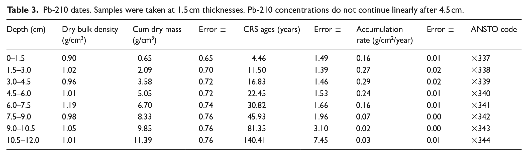
Pb-210 dates. Samples were taken at 1.5 cm thicknesses. Pb-210 concentrations do not continue linearly after 4.5 cm.
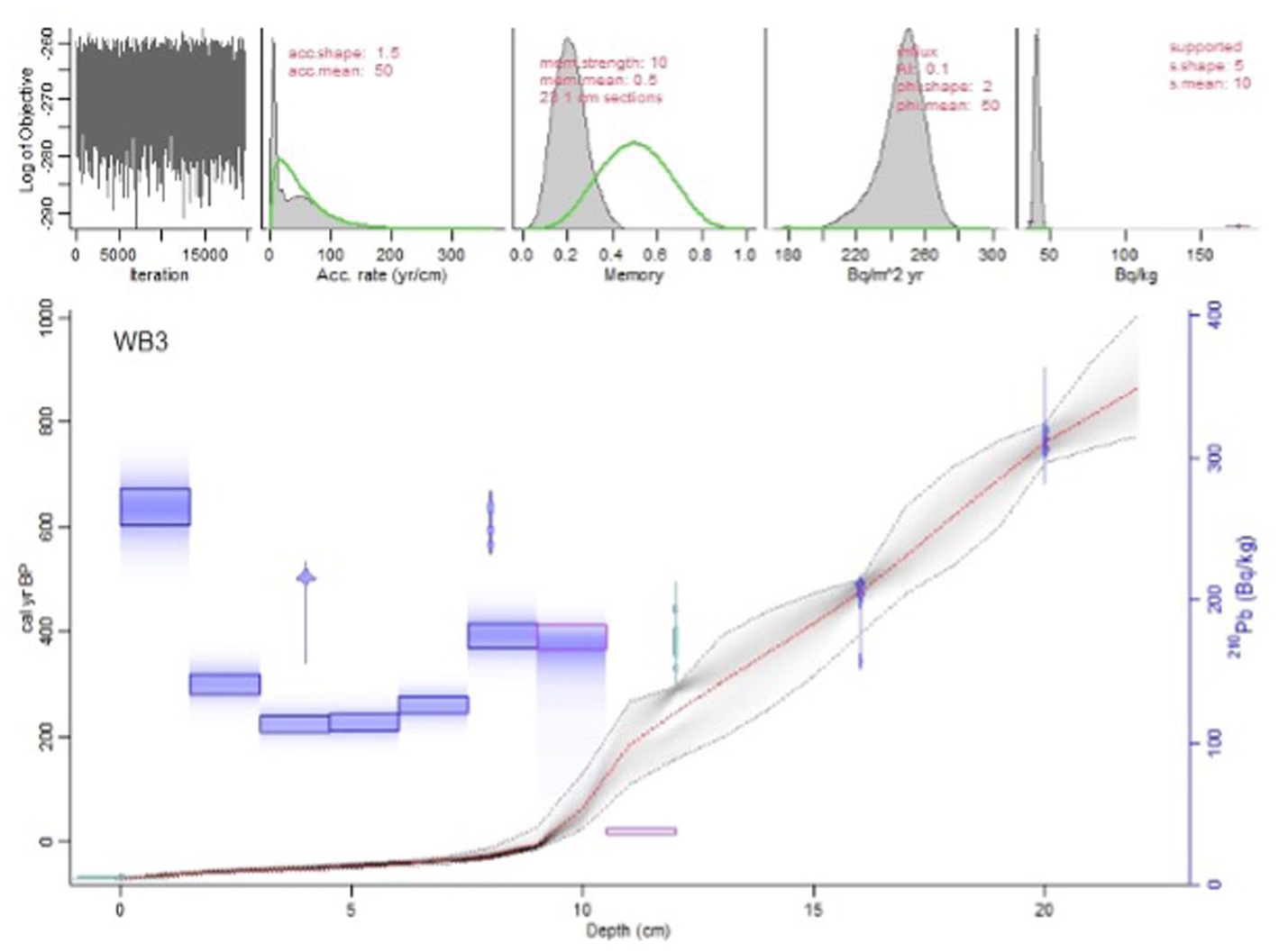
Bayesian age-depth model for WB3 using radiocarbon and lead-210 dates. The model was produced using the mixed modelling R programme ‘rplum’ (Blaauw et al., 2021).
The 22 cm long WB3 core was homogeneous, dark in colour and had no visible structure. It was composed of well-humified, elastic, organic lake mud with silt and fine sand components. Both organic and inorganic influx were relatively high through much of the core (~34, 24 g/cm3/year., respectively) until 10 cm when there was a large peak, before it reduced to lower levels at 8 cm and remained low (3.5, 2.5 g/cm3/year., respectively) until the top of the core.
There were few noticeable peaks in CHAR (mm2/cm3/year) for WB3 (Figure 4) until the mid-20th Century, when a number of charcoal peaks appear to correspond roughly to known fire events (Figure 6). Charring Intensity (Table 4) was also relatively consistent throughout the core, showing a mean value of 4.2 °C.s.106 (σ = 0.24). There was a noticeable peak in maximum Charring Intensity at ~500 cal. years BP coinciding with a slight increase in CHAR, and several in the early 2000s also coinciding with the large increase in CHAR. Minimum Charring Intensity values were also noticeably lower in the late 20th Century than in other periods.
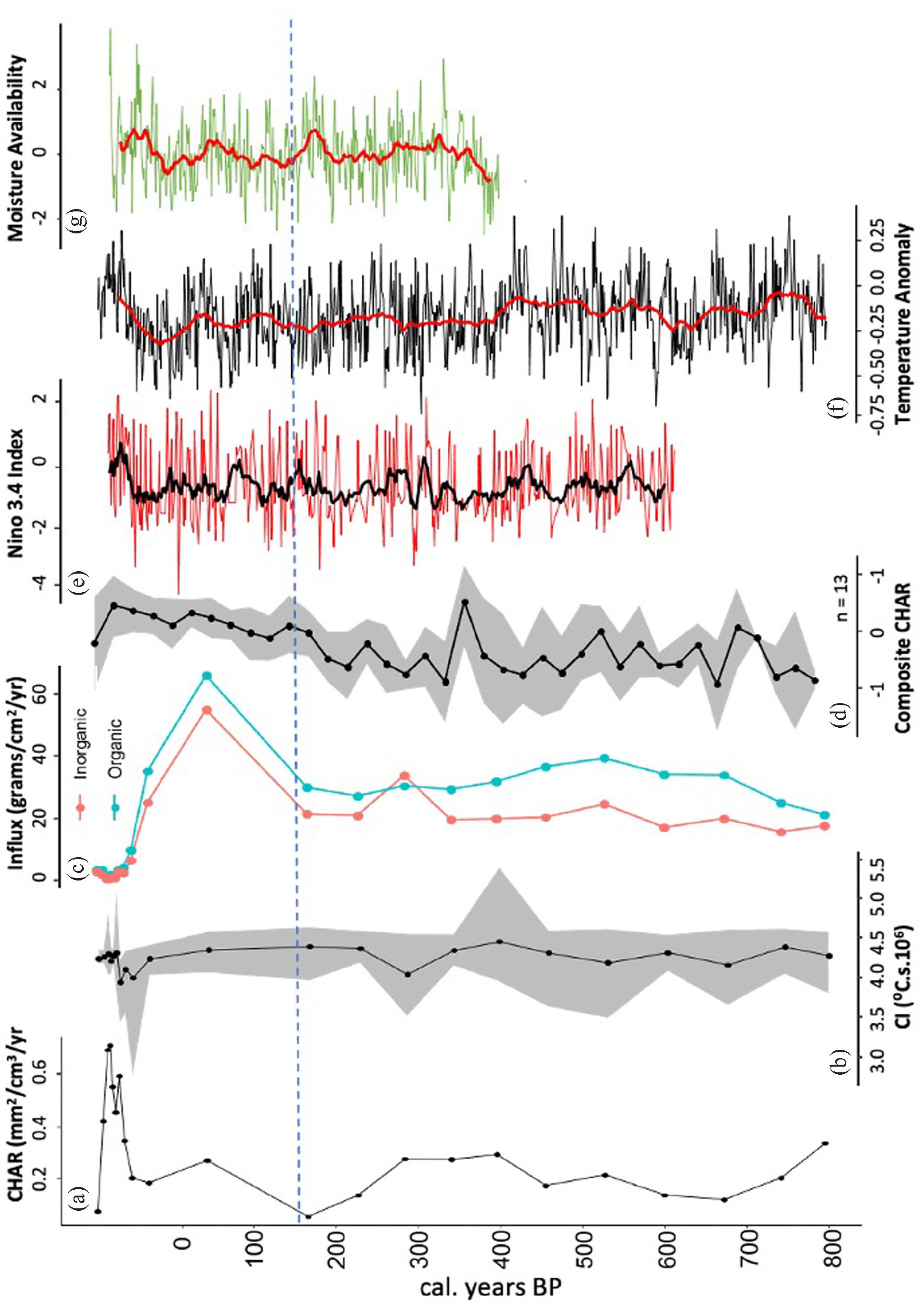
Long-term fire history of Lake Werri Berri. (a) Charcoal Accumulation Rate (CHAR) (mm2/cm3/year) suggests relative area burnt. (b) Charring Intensity (°C.s.106) represents the severity or intensity of the fire. The black line and dots represent the mean values, shaded areas represent the minimum and maximum Charring Intensity values. (c) Organic/Inorganic influx of WB3 in g/cm2/year. (d) Composite record of biomass burning in southeast Australia (n = 13) representing large scale trends in fire across eastern Australia. (e) Significant events (±0.5) of El Niño Southern Oscillation (ENSO) strength from the Niño 3.4 index. A 10-year rolling mean (black line) is used to show trends. (f) Southeast Australia temperature reconstruction (Gergis et al., 2016). A 50-year rolling mean (red line) is used to show trends. (g) Australia and New Zealand Drought Atlas (ANZDA) from Palmer et al. (2015). A 10-year rolling mean has been applied to show trends. The dashed blue line denotes 1788, when it is generally accepted that Europeans arrived in Australia.
Summary statistics for Charring Intensity data from Lake Werri Berri. The number of samples analysed, mean CI and standard deviation of each sampled depth are presented.
Discussion
Late-Holocene (pre-European) fire regime at Lake Werri Berri
The charcoal record from Lake Werri Berri is presented in the context of regional climate over the past millennia in Figure 4. Previous work in two other lakes of the Thirlmere Lakes region, Lake Baraba (Black et al., 2006) and nearby Dry Lake (Rose and Martin, 2007) suggested little vegetation change in the surrounding catchment and region during the past 1000 years, with the exception of a reduction in tree cover at Dry Lake after the arrival of Europeans. Sampling resolution was higher during the post-European period (~13 year/cm) than pre-European period (~68 year/cm). CHAR was relatively low and stable across much of the WB3 core with no apparent peaks until the 20th Century, suggesting limited fire activity in the catchment from ~850 cal. years BP, a period corresponding to increased warming in southeast Australia between ~1000 and 500 BP (Gergis et al., 2016). Changes in Charring Intensity are also muted throughout the WB3 sequence, potentially a consequence of the relatively short time interval covered which seems to have captured relatively few fire events. Fires that did occur produced relatively high Charring Intensity (average of ~4 °C.s.106) events.
In contrast to Lake Werri Berri, charcoal influx at Myall Lakes (Mooney and Maltby, 2006) and nearby Broughton Island (Mooney et al., 2020) on the Central Coast of NSW increased between 785 and 1500 AD, which was attributed to potentially heightened temperatures corresponding to the European Mediaeval Warm Period (MWP). Similarly, Little Llangothlin Lagoon (Woodward et al., 2014), further inland and at higher elevation (~1400 m asl) also saw increased charcoal influx during the MWP chronozone. The incongruity in CHAR between sites may be due to dating uncertainty, differences in sampling resolution between sites, and potentially the spatial heterogeneity of the landscape created by anthropogenic burning. It could also partially be the result of spatial heterogeneity of Australia rainfall (Taschetto et al., 2016). Present day rainfall at Lake Werri Berri is lower than at the coast. The reduced moisture availability in southeast Australia during the MWP, resulting from a poleward shift in the Southern Hemisphere Westerly winds (Perren et al., 2020; Saunders et al., 2012) may have exacerbated this dryness at Thirlmere Lakes, and hence caused a reduction in vegetation biomass and subsequent fire occurrence (Mariani et al., 2018, 2019).
The low CHAR at Lake Werri Berri may also have been the result of small patch burning by Indigenous peoples living in the vicinity of the lakes. It has been argued that low intensity patch burning can result in low CHAR levels (Mooney and Maltby, 2006). However, mean Charring Intensity was high (~4.2 °C.s.106) during the pre-European period, suggesting fires of relatively high severity or intensity throughout the last millennia.
At ~400 cal. years BP (Figure 4c), there was a slight increase in charcoal influx that persisted for approximately 150 years. This was accompanied by slightly increased mean Charring Intensity, and the highest maximum Charring Intensity values at Lake Werri Berri, and suggests a relatively intense fire contributed charcoal to the lake. It is unclear whether this fire(s) was in close proximity or distant to the lake itself, which perhaps explains the relatively low influx. The increased fire intensity or severity could have been the result of biomass build-up in the understorey caused by wetter conditions which increased connectivity of available fuel, leading to more severe fires (Bradstock et al., 2009). Temperatures were cooler in southeast Australia from about 500 cal. years BP (Gergis et al., 2016) coinciding with increased rainfall and persistent La Niña phases (Emile-Geay et al., 2013; Palmer et al., 2015; Tibby et al., 2018).
For a period of approximately 150 years prior to the arrival of Europeans in Australia, CHAR was low (Figure 4a) and this coincided with a period of strengthening El Niño (Figure 4e) and higher precipitation (Figure 4g). The period between AD 1730 and 1760 was described by Palmer et al. (2015) as one of the wettest phases of the past millennia, analogous only to the wet period in the 1950–1970s. It has been suggested that the First Fleet arrived in eastern Australia (in AD 1778) during a strong La Niña period with ample rain, which was subsequently followed by a strong El Niño (Gergis et al., 2010; Tibby et al., 2018). The increased precipitation during the period of increased rainfall could have reduced ignition and fire spread.
Fire and people prior to European occupation
The environmental impact of Indigenous fire management prior to European settlement is still uncertain, with much of the dispute centred around generalisations made using early ethnographic descriptions (Benson and Redpath, 1997) and paleoenvironmental methods that exam fire regimes at different spatial scales (Adeleye et al., 2021, 2022; Fletcher et al., 2021a; Mooney et al., 2011). A study from northern Tasmania showed that the recent encroachment of temperate rainforest into important grasslands has occurred due to the cessation of Indigenous burning that had occurred for many millennia at the site (Fletcher et al., 2021b). While the modification of the Australian landscape by Cultural Burning practices may occur across a range of environments, the likelihood is that cultural practices and demographics of Australian Indigenous peoples were variable in space and employed to better utilise available resources (Williams et al., 2015a, 2015b, 2015c).
It is unclear to what extent, if any, Indigenous people applied fire systematically at Lake Werri Berri. The late-Holocene appears, in the archaeological record, as a time of intensive population expansion and technological innovation among Indigenous people in the Sydney Basin (Hiscock and Clarkson, 2000; Lourandos, 1983; Williams et al., 2015a, 2015b, 2015c), which Europeans would have encountered when they first arrived on the continent. Interestingly, despite the widespread acceptance that Indigenous people burned the landscape extensively as a means of resource management (Flannery, 1994; Gamage, 2011) the extent to which this appears in the charcoal record is still undetermined and disentangling the anthropogenic signal from ‘natural’ fires using charcoal analysis can be complicated, with little evidence for regional-scale interference by humans in fire regimes (Mooney et al., 2011, 2012). CHAR at Lake Werri Berri suggests only subtle variation, perhaps because Indigenous groups occupying the region surrounding these lakes did not sustain a systematic culture of fire management, or that their use of fire left little discernible evidence in the record (Figure 4).
Haberle and Ledru (2001) and Mooney et al. (2011) suggested that rapid periods of climate change promoted increased charcoal accumulation in Australia, regardless of human activity, instead linking increased fire activity with climate variability. In contrast, other studies (Black et al., 2007) argue that low charcoal influx levels (Lake Baraba and Kings Waterhole in the Sydney Basin) during the late-Holocene could be due to frequent, low intensity burning by people to mitigate the effects of climate on the natural fire regime. As is shown here, however, there appears to have been little change in fire regime, particularly in the severity or intensity as measured by Charring Intensity, across the transition between Indigenous and European land management at Lake Werri Berri, which suggests that fires in the vicinity of the lake were relatively unaffected by anthropogenic ignitions (i.e. Cultural Burning).
The Hawksbury Sandstone dominated landscapes of the Sydney Basin (including Thirlmere Lakes National Park) are relatively unproductive and sustain relatively low densities of fauna, making it unlikely Indigenous people occupied marginal regions of it in great numbers (Recher et al., 1993). In the Thirlmere Lakes region, frequent burning could have led to subtle changes in vegetation or altered successional stages of vegetation communities (‘seres’) rather than resulting in broadscale changes to dominant canopy species, the community structure (physiognomy) or to the type of vegetation (e.g. forest to woodland or forest to grassland). The pollen records of other sites in the vicinity of Lake Werri Berri suggest that variable moisture may have contributed to changes in the woodland structure during the mid- to late-Holocene (Black et al., 2007; Forbes et al., 2021). Perhaps even more subtly, Indigenous use of fire might have targetted specific elements of the vegetation that supported edible or useful species, such as the littoral vegetation of the lake edges. Equally plausible is the possibility that the lakes of the Thirlmere system provided resources that did not require fire, or that other cultural practices or taboos did not result in application of fire to the landscape. Local Indigenous groups were undoubtedly familiar with the environmental conditions and likely recognised the effects of fire on the lakeside environment.
Post-European fire regime at Lake Werri Berri
A number of recent studies (Adeleye et al., 2021; Fletcher et al., 2021a; Mariani et al., 2022) have argued that the cessation of cultural burning practices following European colonisation led to vegetation assemblages more prone to extreme wildfires. If true, the lack of change in the fire regime from the late pre-colonial period into the period of European occupation at Lake Werri Berri suggests that Indigenous peoples were not actively managing the fire regime around the Thirlmere Lakes in a way that was apparent in our proxy data.
Following the transition between Indigenous land management and the European occupation, little apparent change can be seen in the charcoal record (CHAR and Charring Intensity) at Lake Werri Berri. This is despite ethnographic evidence of Indigenous occupation in the vicinity prior to European settlement and agricultural activities in the region from the mid-1800s onwards. The European occupation in the Thirlmere Lakes catchment was however likely to be subtle, as agriculture, land clearing or grazing were (and are) largely absent and hence the vegetation remained in a relatively ‘natural’ state, leading up to the State Park and National Park declaration.
The smallpox outbreak that spread from Sydney in 1789 and warfare between colonists and Indigenous peoples led to large disruptions in the traditional lifestyles of Indigenous peoples in the Thirlmere Lakes area by around 1815. Changes to the fire regime at Lake Werri Berri following this catastrophic change are, however, slight. CHAR and Charring Intensity remain relatively stable throughout the last several 100 years prior to European disruption of Indigenous people and into the early 20th Century, suggesting little change in fire intensity or severity despite the upheaval in Indigenous society. At nearby Dry Lake, there was a decrease in arboreal pollen following the introduction of woodcutting by Europeans in the mid 1800s (Rose and Martin, 2007). However, it appears there was little change in fires during this period at Lake Werri Berri despite nearby deforestation.
The lack of change over the transition between Indigenous and European occupation (Figure 5) perhaps suggests that the fire regime was not being actively managed when Europeans arrived in the area or is subtle and not readily apparent at the resolution sampled in this study. The fire regime appears to have remained unchanged until Thirlmere Lakes National Park came into heavier use as a recreation area in the mid-20th Century. However, after Europeans began to settle in the Thirlmere Lakes region in the mid-1830s for dairy and wheat farming, tree cover was reduced noticeably and grasses increased (likely crops and improved pastures), most probably in relation to timber cutting for firewood and land clearance for farming (Rose and Martin, 2007). The region was known at the time as The Oaks, named for the abundance of sheoaks (Allocasuarina and Casuarina species), which were used for firewood and for shingles (NPWS, 2019). However, the main woodcutting and agricultural activities of Europeans occurred on alluvial soils along watercourses and on the more nutrient rich shale soils (Recher et al., 1993) which are rare in the TLNP catchment.
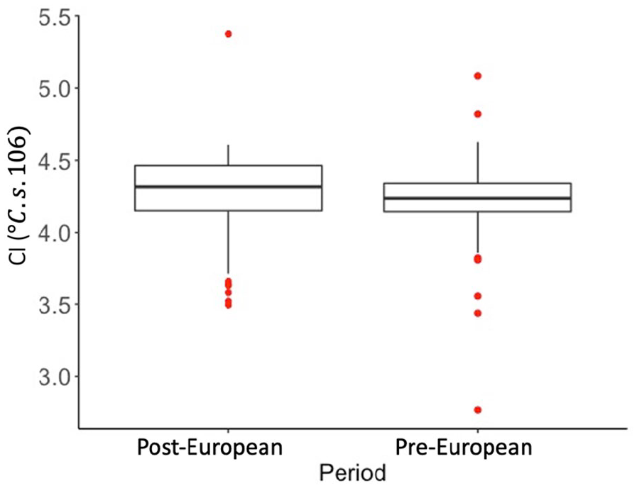
Box and whisker plot of Charring Intensity of the pre- (pre-1788) and post-European (post-1788) periods of occupation at Lake Werri Berri. There is little variation in Charring Intensity across the two periods.
The limited land use around TLNP means that there was perhaps negligible interference to the vegetation and fire regime during the early European period. The temporary increase in organic and inorganic influx at ~150 years BP (Figure 4c) and the return to greater CHAR roughly corresponds with the instalment of a pumphouse in AD 1867 to supply water for trains (NPWS, 1998, 2019) and with the beginning of tourism at Thirlmere Lakes, likely in the early 20th Century as the local railway became established (to Thirlmere). This increased sedimentation also likely reflected roadbuilding, as an unsealed road was established through the park (NPWS, 2019), directly parallelling Lake Werri Berri, and undoubtedly resulted in increased erosion during construction. The influx of organic and inorganic sediment returned to previous levels by the beginning of the 20th Century, then decreased precipitously during the 1960s onwards, perhaps as the modern management of the National Park became entrenched.
The increase in fire activity from the 1960s onwards (Figure 6, Blue shading) followed a period of enhanced precipitation in south-eastern Australia from the mid-20th Century, with correspondingly high lake levels in the Thirlmere Lakes during that period (Chen et al., 2021). The increased moisture availability in the catchment area would have resulted in changed vegetation structure and led to increased fuel load and connectivity. The increased biomass availability and increased activity as the park became popular for recreation likely explains the elevated fire activity in the late 20th Century.
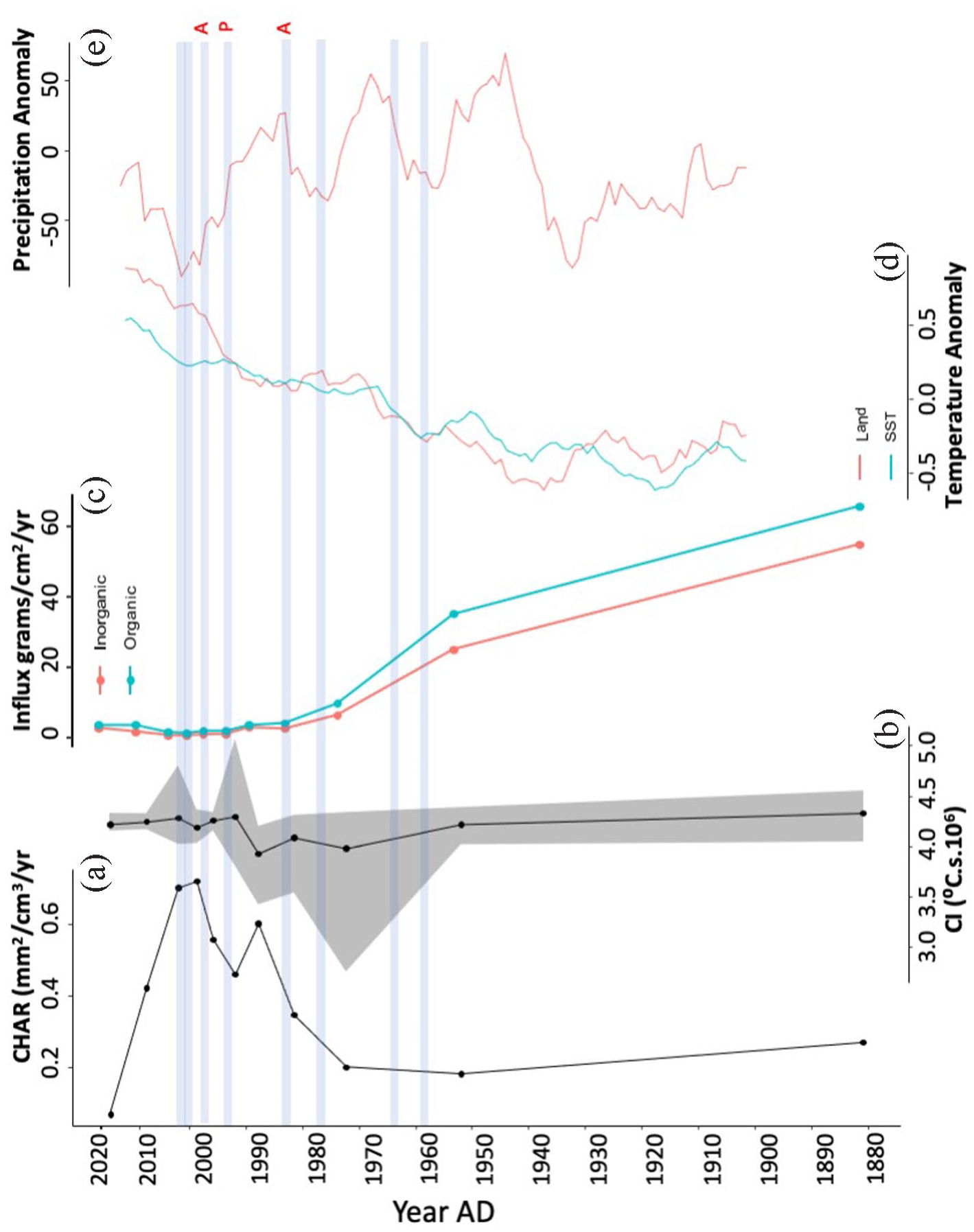
20th Century fire history of Lake Werri Berri compared to other proxies. (a) Relative area burnt is represented by Charcoal Accumulation Rate (CHAR) mm2/cm3/year. (b) Fire severity or intensity is characterised by Charring Intensity. The black line and dots represent the mean values, shaded areas represent the minimum and maximum Charring Intensity values. (c) Organic/Inorganic influx (g/cm2/year). (d) Land temperature anomaly of southern Australia (calculated by BOM) and Sea surface temperature (SST) anomaly extracted from the NOAA ERSST v5 gridded data set. Both land and SST data are smoothed using a 10-year rolling mean. (e) Southeast Australia precipitation anomaly (calculated by BOM) smoothed with a 10-year rolling mean. The shaded line represents known fire events, and the red letters represent (a) arson and (p) prescribed burns, respectively. Unlabelled fires have undefined ignition sources.
Though the temporal resolution of this study does not allow for precise identification of individual fire events, the increase in CHAR from the mid 20th Century onwards suggests an increase in fire activity in the catchment. The peaks in CHAR corresponding to the 2005–2006 and 1998 fires produced the highest recorded Charring Intensity values during the 20–21st Century, suggesting higher severity or intensity fires than previous ones. It is interesting to note that the Charring Intensity corresponding with the 1998 fire were high despite it being a ‘controlled burn’ (controlled fires used by the NPWS to reduce fuel load) and may have been a consequence of heightened biomass build-up after a 10-year hiatus in fire.
Known fire events in the proximity of TLNP over the past 60 years all occurred during relatively drier periods (See Figure 6e) in eastern Australia, with the exception of the 1998 fire, which was a ‘controlled burn’. The increase in fire activity from the 1980s onwards happened in conjunction with an increase in recreation activities after the park was gazetted. The 1988 and 2003 fires were associated with arson and only the 1998 fire is recorded as a controlled fire. The two large fires in 2001 and 2006 burnt 60% and 100% of TLNP, respectively (NPWS, 2019). The 2006 fire occurred during low water levels and a regionally widespread drought, causing an exposed peat bed in Lake Gandangarra, another of the Thirlmere Lakes, to ignite, which resulted in an underground fire that burned for over 2 months (NPWS, 2019). All three fires in the late 1990s and 2000s occurred during a period known as the ‘Big Dry’ (Gergis et al., 2012), which has been described as the worst drought since Europeans arrived in Australia. Tibby et al. (2018) suggested that this reduced moisture availability (Figure 6e) was linked to increasing temperatures (as modelled in Gergis et al., 2016).
A number of other sites in eastern Australia experienced large increases in charcoal influx in the 20th Century, likely a result of the increased precipitation, and this is evident in the composite records of Mooney et al. (2011, 2012), in the composite record produced herein (Figure 4) and in Adeleye et al. (2021). Worimi Swamp (Mooney and Maltby, 2006), Diggers Creek, Kosciuszko National Park (author’s unpublished data), Kings Tableland (Mooney and Maltby, 2006) and Tea Tree Swamp in East Gippsland (Gell et al., 1993) all recorded increased charcoal influx since the beginning of the 20th Century, although this generalisation is not universal as others, such as Bondi Lake and Killalea Lagoon (Dodson et al., 1993) saw decreases in overall charcoal during in the post-European period, which perhaps reflects differences in land-use or vegetation. Sites with high fire activity in the 20th Century may be attributed to arson and accidental ignitions resulting from higher land-use (e.g. recreation).
There is still considerable debate about whether wildfires in Australia have become more severe with the increased warming resulting from global climate change. Recent research has offered conflicting conclusions of whether fire severity has increased during recent decades. Tran et al. (2020) argued that fire severity in Victoria has increased over the past 30 years. In contrast, Collins et al. (2021) found little increase in fire severity in the large southeast Australia fires of 2019/2020 and suggested that mega-fires are rare but significant events in forested environments. Both studies, it should be noted, relied on satellite data for their assessments of fire severity, which extends back only the last few decades and hence they do not capture fires prior to the onset of significant anthropogenic influences on climate. Charring Intensity at Lake Werri Berri (Figure 6b) during the 20th and early 21st Centuries was stable, suggesting that despite the increase in CHAR, there was little discernible change in the severity or intensity of fires in the region. The data collected from Lake Werri Berri indicates that it is difficult to test hypotheses of Cultural Burning practices and it is as yet unclear how and to what extent, Cultural Burning affected fire severity or intensity prior to European settlement.
Conclusion
This study examined the fire history of Lake Werri Berri using both established charcoal techniques (CHAR) and a novel approach to quantify fire severity or intensity using FTIR, over the past ~850 years, encompassing the transition between Indigenous and European periods of occupation. It found little change in the area burnt and severity or intensity of fires during this transition in land use but did find subtle differences in the first decades of the 21st Century. Though it is quite probable that Indigenous peoples were exploiting the Thirlmere Lakes region and using the freshwater and resources within the lakes themselves, their use of fire is not easily identifiable in the charcoal record. Perhaps most significantly, the fire regime of the site in the period from ~850 years BP to the mid-20th Century was relatively stable. The similarities between the pre-colonial period of Indigenous land stewardship (~850 years BP to AD ~1830) and this early European period (AD ~1830 to ~1950), suggests that Indigenous fire in the Thirlmere lakes landscape was limited in context.
Fire severity data suggests there has not been a discernible, directional change over the recent past at Thirlmere Lakes. However, with the recent mega-fires (e.g. 2019–2020 fires in New South Wales) burning at unprecedented scales (in the historic record), further research that extends the record of fire severity further than historic records may shed some light on whether contemporary wildfires are unprecedented, or a part of the natural cycle of wildfires in Australia.
Footnotes
Author contributions
Mark Constantine IV designed and conducted laboratory experiments, wrote the manuscript, and produced figures and tables. Haidee Cadd processed and dated the radiocarbon samples and contributed to the manuscript. Xiaohong Zhu conducted laboratory experiments. Scott Mooney designed the laboratory experiments, contributed to the manuscript and statistical analysis.
Funding
The author(s) disclosed receipt of the following financial support for the research, authorship, and/or publication of this article: Mark Constantine IV is supported by an Australian Government Research Training Programme (RTP) Stipend and RTP Fee-Offset Scholarship through Federation University Australia.