
Abstract
Coasts are dynamic environments prone to the physical and social impacts of climate change. Examining the archaeological and environmental records of coastal areas can deepen our understanding of how humans respond to changing environmental conditions. In this article we consider how sea-level rise impacted coastal environments through time, and how these changes could pose opportunities or challenges to local indigenous populations. We present new findings of coastal zone transformations and past settlement patterns for Borikén, the largest island of the Puerto Rican archipelago, during the Holocene. We use paleogeographic modeling to reconstruct ecosystem availability for six discernible coastlines at 1000-year resolutions that accounts for past relative sea-level (RSL) heights and paleotidal ranges. We then compared ecosystem availability trends with the spatiotemporal distributions of available archaeological data to demonstrate the localized impacts of climate-related RSL rise across the island’s coastal ecosystems and suggest a consideration of habitat availability in past decision-making strategies. We observe a strong presence of Archaic Period sites in the island’s southwest coast where high coastal ecosystem availability and stability were present during this period. We also observe a significant expansion of intertidal ecosystems beginning at 3 kya for the north-central, north-eastern, south-central, and south-eastern coastlines that correspond to the appearance of materials associated with Early and Late Ceramic Periods cultures in these areas. This comparison of differential coastal transformations and site distributions conveys a deeper understanding of factors involved in past decision-making strategies and contributes to the emerging picture of human adaptations amidst changing environmental conditions.
Keywords
Introduction
The rich biodiversity of coastal areas makes them highly attractive settings for human habitation. Previous studies estimate that roughly 40% of the global population lives within 100 km of a coastline and between 0 and 10 m above present sea-level elevations (McGranahan et al., 2007; Small and Nicholls, 2003). Given the current rates of sea-level rise and the coastal population growths expected in the next decades, coastal flooding and coastline changes pose a threat to the livelihood security of millions of people (Kulp and Strauss, 2019; Neumann et al., 2015). However, sea-levels have risen in the past. The rate of global sea-level rise between the end of the Last Glacial Maximum to the end of the Mid-Holocene was up to nine times faster than the rate at the present (Lambeck et al., 2014). These changes impacted vast expanses of formerly lowland coastal zones in what can be considered to be a short timespan in geological terms (Bailey, 1983). In human terms, the experience of rising sea-levels was not limited to seeing coastal plains become submerged and offshore places. It included coastal erosion and accretion, changes in ecosystems, and overall transformation of land- and seascapes. In order to understand the risks that changing sea-levels pose to modern coastal communities, we need to examine the processes of coastal transformation within the spatio-temporal range of human experience (Mertens and Craps, 2018).
Islands, in particular Small Developing Island States (SIDS), face singular challenges given their smaller geographical areas and compounding impacts from changes in precipitation, storms and storm-surges, in addition to many complex historical and social processes affecting adaptive and mitigating capacities (Douglass and Cooper, 2020; United Nations Development Programme [UNDP], 2010). Fine-tuning our understanding of risk can make significant contributions to the ability of SIDS to respond to climate change. In this article, we look at the neotropics to assess how rising sea-levels modify coastal zones on islands, and how people responded to those changes through time. The answer to this inquiry can help us better understand what can be expected of the future impacts of sea-level rise within human-relevant scales. To these ends, we compare Pre-Hispanic Indigenous site distribution patterns and the trends of Holocene coastal ecosystem availability for Borikén, the largest island of the Puerto Rican archipelago. The objectives for our research are threefold: (1) to reconstruct the general geographical transformations and ecosystem availability trends for the island’s modern nearshore regions for the Holocene from 10 kya through present; (2) to analyze spatiotemporal patterns of archeological site distributions across the coastlines of Borikén during the different periods of indigenous occupations prior to the Spanish Invasion (~5.0–0.5 kya); and (3) to discuss the reconstructed coastal transformations patterns for the early periods of human occupation.
Study Area
Geographic and geomorphological background
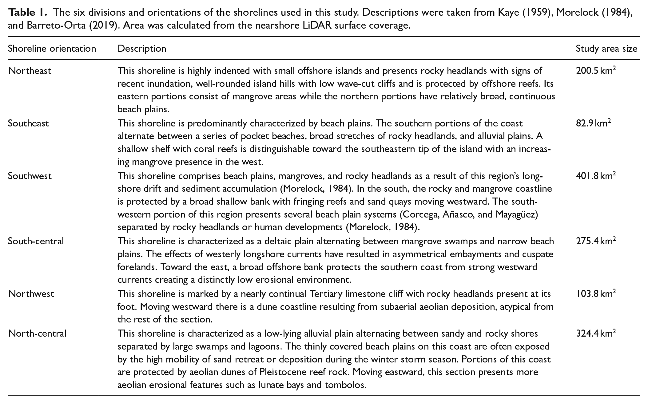
Located on the northeastern corner of the Caribbean Archipelago (see Figure 1), Borikén is a nearly rectangular island, stretching 178 km east to west and 62 km north to south. The modern coastlines of Borikén stretch over 1285 km long and reflect the complex interplay of past and current sediment transport processes with varying intensities (Barreto, 1997; Barreto et al., 2017). Several long-term studies have described and divided the island’s shorelines according to their coastal features (Turner, 1956), geomorphology (Kaye, 1959), or sediment composition (Morelock, 1984; Morelock and Barreto, 2003). Kaye’s shoreline typologies (1959) laid the groundwork for later studies as his delineations accounted for Holocene sedimentary processes, topography, orientation, climate, and geology factors. While the physical or sedimentary characteristics of the shoreline are important considerations to understand extant morphology, the geomorphological context of each is also central to assess the long-term dynamism of the coast. Building from Kaye’s work, the studies of Morelock, 1984; Morelock and Barreto, 2003 and Barreto-Orta (2019) have characterized the varying geomorphological contexts using geographic orientations. These studies have identified five main coast types: sandy beach, vegetated, rocky, anthropogenic, and alluvial plains. Sandy beaches are the most common coastal type (30%) followed by the vegetated (28%) type (primarily consisting of wetlands and mangroves) and rocky shorelines (15%) which include volcanic, sedimentary, and metamorphic substrates (Barreto-Orta, 2019). Alluvial plains are the least common natural coast type. These plains are formed by the accumulation of unmodified silty and muddy sediments from riverine processes and occur mostly in the southeast and south-central portions of the island. Anthropogenic coasts (18%) include all non-natural structures. For all coastal types, 39% are currently erosional, 40% are accretionary, and 21% are stable (Barreto et al., 2017: 27). For this article, we use the geographic orientations of Kaye’s shoreline typologies to delineate our shoreline divisions and the geomorphological descriptions of Morelock (1984) and Barreto-Orta (2019). The shorelines’ descriptions, coastal stretches, and area (km2) are described in Table 1.
The six divisions and orientations of the shorelines used in this study. Descriptions were taken from Kaye (1959), Morelock (1984), and Barreto-Orta (2019). Area was calculated from the nearshore LiDAR surface coverage.
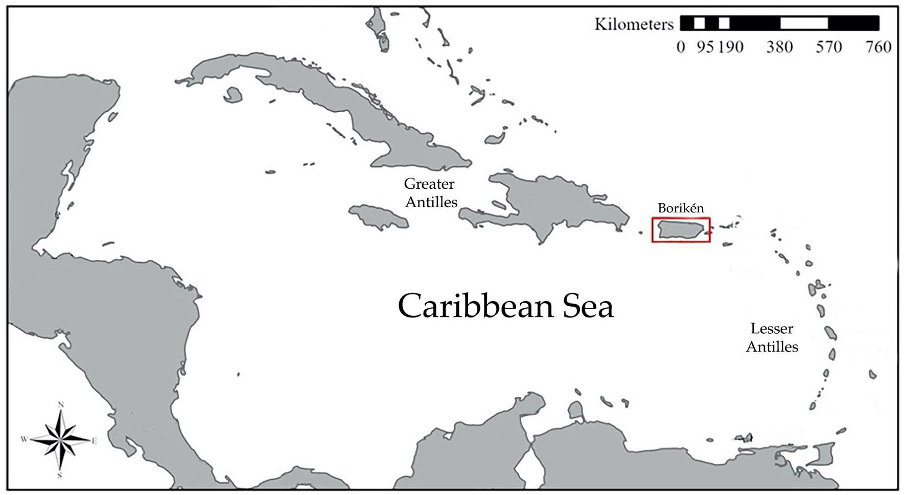
Map of the Caribbean showing the location of Borikén (Red).
Archeological background
Archeological classifications of the indigenous occupation of the Caribbean Islands have subdivided time in three large periods based on the characteristics of the archeological assemblages: Archaic, Early Ceramic, and Late Ceramic (Hofman and Antczak, 2019; Keegan and Hofman, 2016; Napolitano et al., 2019; Oliver, 2009; Rodríguez Ramos, 2010). Distinctions are based on widely accepted subdivisions of Caribbean archeology, but, while the types of artifacts within these periods are classified in typological series and styles – such as pottery of the Saladoid series, for example – their expressions on individual sites or between islands are often diverse. The archeological chronologies and sites discussed in this paper are derived from absolute and relative dating of cultural evidence. Radiocarbon dates are presented in cal. BP when possible to maintain their original resolutions.
The Archaic Period in the Caribbean spans 5500–1800 ya (Hofman and Antczak, 2019; Napolitano et al., 2019). For Puerto Rico, the earliest available evidence of human presence is reported for the islands of Borikén and Vieques at 4713 cal. BP and 4200 cal. BP respectively (Rodríguez Ramos, 2010: 44, Napolitano et al., 2019). It is possible that earlier sites are today underwater (Rivera-Collazo, 2019; Siegel et al., 2015). The Archaic period includes permanent settlements, specialized exploitation sites for quarrying or for food resource processing, and often sophisticated use of caves inland. Tools include ground and flaked stone toolkits, together with shell artifacts, pottery, and a rather impressive set of amulets and other carved items in bone, shell and stone. The toolkits suggest the widespread use of wood too, but these items have not been preserved in the archeological record. These earliest settlements provide evidence of deep knowledge of subsistence resource management and overall landscape modification including forest clearings (Burney et al., 1994), inter-island voyaging (Hofman and Hoogland, 2011; Rivera-Collazo, 2011, 2015a), transport of plants and animals (DeFrance et al., 1996; Turvey et al., 2007), and riparian and coastal foraging practices (Pagán-Jiménez, 2013; Pagán-Jiménez et al., 2015; Reid et al., 2018; Rivera-Collazo et al., 2015).
The Early Ceramic Period for Borikén is largely characterized by the identification of pottery of the Saladoid and Huecoid typological series (which include the Saladoid series Hacienda Grande and Cuevas styles and the La Hueca style of the Huecoid series). The people using these ceramic objects moved into the archipelago during a wave of migration events starting around 2600 cal. BP (Napolitano et al., 2019). These people encountered and interacted with a plural and diverse cultural setting of the people that used material culture characteristic of the Archaic period. Sites with pottery of the Saladoid or Huecoid series present a broad spectrum diet that includes cultivation, horticulture, import of captive mammals, and use/management of wild resources from inland, coastal, and offshore settings (including mangroves, estuaries, reefs, sandy beaches, and sea grass environments)(Reid et al., 2018). The presence of a complex lapidary and microlapidary industry with sophisticated and specialized bead and amulet work suggests differential use of, and regulated access to, inland and coastal resources. The distribution of sites suggests territoriality, with settlements near river floodplains and river mouths with good access to productive lands and diverse natural resources – such as rich tropical woods, clay, rock outcrops, and other forest resources – combined with strategic outposts that allowed for observation of the sea, possibly to oversee and control maritime routes (Rivera-Collazo et al., 2021). The absolute chronological boundaries are ambiguous, but the accepted dates place the Early Ceramic between 400 BCE (2.6 kya) and 600 and 800 CE (1.4–1.1 kya) (Curet, 2003; Napolitano et al., 2019; Reid et al., 2018).
Beginning somewhere between 600 and 900 CE (1.4 and 1.1 kya), the Late Ceramic Period is characterized by landward expansion of settlements, the development and systematization of ceremonial centers with ballcourts and plazas, the presence of religious and high-status objects made of stone and shell, and the gradual development of a series of ceramic styles, grouped as the Ostionoid series, that are coarser and less ornate than those of the Saladoid ceramic series. Settlement patterns suggest an increase in population density and site diversity, including large settlements associated with smaller sites – such as homesteads or farmsteads – around them; and complex and possibly ritual use of caves and caverns from the coast to deep inland (Bérard, 2013; Curet, 2005). While more research is needed, the distribution of sites suggests preference for coastal areas during the earlier decades of the period, and later intensification of habitation of the mountainous interior (Curet, 2005). The distribution of petroglyphs marking rivers, caves, and coasts suggests existence of evident territorial boundaries or of significant points of contact in and with the landscape (Oliver, 2009). The archeological record suggests agricultural intensification and systematic relationship with other islands, creating a loosely unified ideological system around what is known today as the Taino. This identity or ideological cohesion between and within islands is identified by Oliver (2009) and by Rodríguez Ramos (2010) as tainoness. The Late Ceramic Period is considered to end in the early 16th Century with the Spanish invasion of Borikén in 1508 where after years of bloody and intense warfare and resistance from the local chiefs and their people, the surviving islanders were subjected to widespread genocide and colonization (Anderson-Córdova, 2017; Curet, 2011; Oliver, 2009; Rodríguez Ramos, 2005).
Holocene sea level change
Throughout the Archaic, Early, and Late Ceramic Periods, coastal areas were easily accessible for settlement, horticultural activities, and marine foraging strategies (Bates, 2014; Pestle et al., 2021; Rivera-Collazo, 2015b). Coastal environments remain integral to indigenous identities up to today (García-Quijano et al., 2015; Lloréns and Stanchich, 2019; Valdés Pizzini, 2006). Recent paleoecological and paleogeomorphological studies have demonstrated the value of multi-proxy, high-resolution datasets for research on Late Holocene RSL change, related environmental changes, and impact on human activities within their local, contemporaneous landscapes (Cohen et al., 2016; Rivera-Collazo et al., 2021; Siegel et al., 2015; Urrego et al., 2018).
Holocene sea-level changes are the product of large scale climatic processes at a global scale. The climate of the northeastern Caribbean is highly responsive to regional atmospheric and oceanographic changes (Khan et al., 2017; Rivera-Collazo, 2015b; Walker et al., 2012). Detailed description of climate drivers – such as precipitation, sea surface temperature, or air temperature – are not relevant for the questions propelling this research but are accessible in published literature (Boyd, 2015; Khan et al., 2017; Nyberg et al., 2001; Rodriguez et al., 2019).
Estimated RSLs in the Caribbean at the onset of the Holocene were ∼60 m below modern levels (Khan et al., 2017:13, Lambeck et al., 2014; Walker et al., 2019). High meltwater intake since the end of the Last Glacial Maximum led to fast rates of RSL rise during the Early Holocene (11,700–8200 cal. BP). In the Caribbean, sea-levels rose at a rate 7.4 ± 0.7 m/kya in the northern portions of the basin and 10.9 ± 0.6 m/kya in the southern portions. (Khan et al., 2017; Walker et al., 2019). As the Laurentide ice sheet (LIS) completely dissipated, RSLs began to stabilize during the Middle Holocene (8200–4200 BP) slowing to 0.1 ± 0.8 m/kya by the Late Holocene (after 4200 BP). These changes suggest that sea-levels were still rapidly rising during the beginning of the Archaic period, but stabilized soon after those earlier occupations. Given that most of the social dynamics on the islands occurred during the Late Holocene, we model and analyze the process of RSL rise for Borikén specifically to understand how the coastlines were affected and how people responded through time.
Data and methods
Our analysis requires high resolution identification of land surface characteristics and the reconstructed RSLs for the time period of interest. To identify modern topography, we used a LiDAR dataset produced by Leading Edge Geomatics and collected using a RIEGL VQ880- GII Topobathymetric lidar system in 2018 (OCM Partners, 2021). This dataset permits the construction of 1.0 m resolution bare earth models (BEM) and digital elevation models (DEM). The coverage of this dataset over the modern extents of nearshore areas is presented in Figure 2.
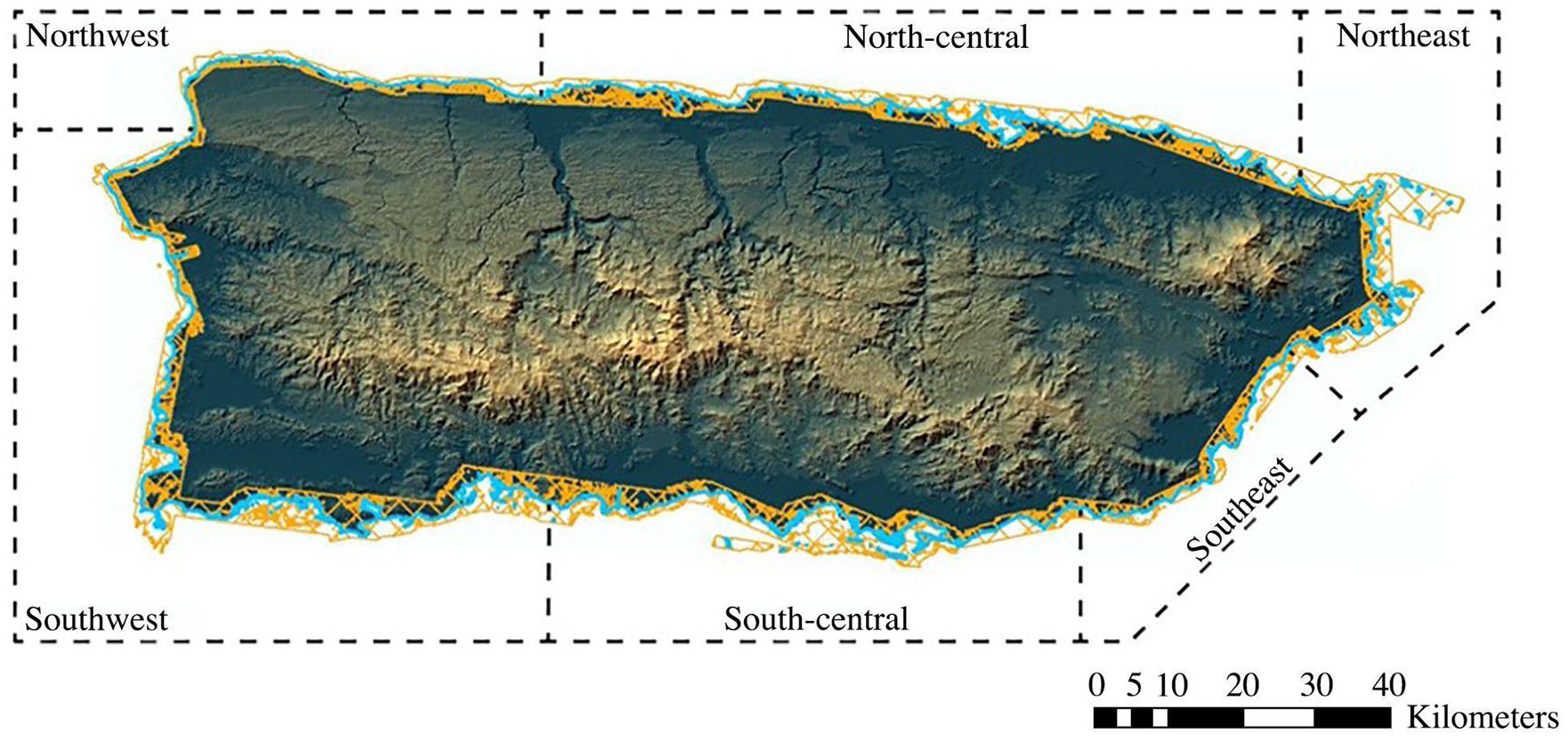
The extent of the 2018 LiDAR topobathy (shown in orange), the 2018 shoreline (shown in blue) and this study’s geographic boundaries for the island’s shorelines (shown in black dashed).
While accurate, modern DEMs alone are not equitable to past topographic and bathymetric surfaces as they do not address the island’s long history of human activity and high population density along the coast nor the tectonic and sedimentary processes that have influenced the island’s coastlines. We acknowledge that better resolution will be achieved with sediment coring and assessment of the deep impacts of modern development and of large scale agriculture, particularly since the 17th Century (Rivera-Collazo et al., 2021; Wallman et al., 2018), which still remain to be conducted. To slightly mitigate the error of modern land use, we filtered out areas of modern human activity that were identified in the latest available National Land Cover Dataset for Puerto Rico (Homer et al., 2004, 2007). These areas include Commercial Salt Production, High Density Urban Development, Low Density urban development, Artificial Barrens, and Aquiculture. These areas account for <0.03% of the total surface area and are therefore not statistically significant. However, further details are needed to understand and parse out areas of high rural and agricultural development that may not be included in the National Land Cover classifications (Homer et al., 2004, 2007).
To model the island’s past coastlines, we created a local RSL curve for Puerto Rico using the recent Caribbean-wide reconstruction of Holocene sea-levels (Khan et al., 2017). Our localized RSL curve was based on 22 index points provided by Khan and colleagues. Their data was derived from radiocarbon-dated mangrove peat samples and A. palmata corals from freshwater and saltwater contexts and resulted in a temporal resolution of 1000 years. Using these values and ranges, we reclassified the filtered DEM surface according to the vertical limits of supratidal, intertidal, and subtidal areas. The supratidal classification identifies areas above the upper paleotidal range values and would be dry land, only be affected by salt water on its lowest sections and during times of extreme storm events. Supratidal areas serve as a proxy for inland ecologies such as subtropical rainforests, grasslands, and upland areas. The intertidal classification areas lie between the maximum and minimum tidal range values and serves as a proxy for several tidal ecologies including mangrove ecosystems, coastal wetlands, and beach environments. The subtidal classification areas fall below the paleo-tidal range and are always submerged. This classification serves as a proxy for potential coral reef, sea grass, and soft bottom ecologies.
For the archeological dataset, we use a subsection of a larger island-wide database originally subsampled to assess the vulnerability of archeological sites between 0and 20 m amsl to the impact of climate-related RSL rise (see Ezcurra and Rivera-Collazo, 2018; Rivera-Collazo, 2020). The chronology of these sites is based on the accepted standard frameworks for ceramic typologies as absolute chronologies are rarely available. The lack of absolute date ranges limits the resolution of the archeological data to broad chronological sequences with very large margins of error. While higher temporal resolutions would be preferred, the resolution of the archeological chronology is comparable with the 1000-year intervals recorded by Khan et al. (2017). We organized the database according to broad pre-Columbian cultural associations homogenized by the reported artifact typologies (Archaic, Saladoid series pottery, Ostionoid series pottery) and filtered out isolated finds, sites with broad classifications (e.g. “Indigenous Era”) or no cultural affiliation assigned, as well as sites where relative dating could not be assessed.
Results
Relative sea levels (RSLs)
The localized RSL curve for Puerto Rico is presented in Figure 3 and accounts for tectonic activity, eustatic sea-levels, isostatic rebound, paleo-tidal ranges, and local factors. Between 9–10 and 7–8 kya, the RSL curve shows sea-levels rising from −17.8 ± 1.2 m to −7.8 ± 1.0 m. This sharp rise likely reflects the initial high meltwater intake that occurred during the Early Holocene. Between 7–8 and 4–5 kya, the local curve shows RSLs still rising, but more slowly as sea-levels rose from −7.8 ± 1.0 m to −2.7 ± 0.9 m. This trend corresponds to the complete dissipation of the LIS during the Middle Holocene. Finally between 4–5 kya and 0–1 kya, the RSL curve shows RSL rise continuing to slow as sea-levels rose from −2.7 ± 0.9 m to 0.1 ± 0.8 m which corresponds to the continued stabilization of regional sea-levels trends in the late Holocene.

(Left) Holocene RSL heights and paleotidal ranges relative to the present day (0 m) for Puerto Rico as derived by Khan et al. (2017). Total % inundation is the overall percent increase of intertidal and subtidal zones for all coastlines since the 9–10 kya period. (Right) The RSL curve for Puerto Rico using the derived RSL heights and paleotidal ranges.
Paleogeographic modeling
Using the microlocal RSL curve and the topographic DEM, we reclassified the coastal areas at the same 1000-year intervals as the RSL curve resulting in 10 surfaces created between the ranges of 0–1 and 9–10 kya. The resulting surfaces and geographic classification ratios are presented in Figures 4 and 5. The coastal reconstructions reflect the varying rates of inundation that occurred during the Holocene. The 9–10 kya surfaces show the greatest extent of dry land areas, gradually reducing at each 1000-year interval. Figure 4 visually presents the geographic changes for the coasts and Figure 5 presents the area percent changes for coastal zone habitats for each coastline from 9–10 kya through 0–1 kya. The individual transformations for each coastline are described below.
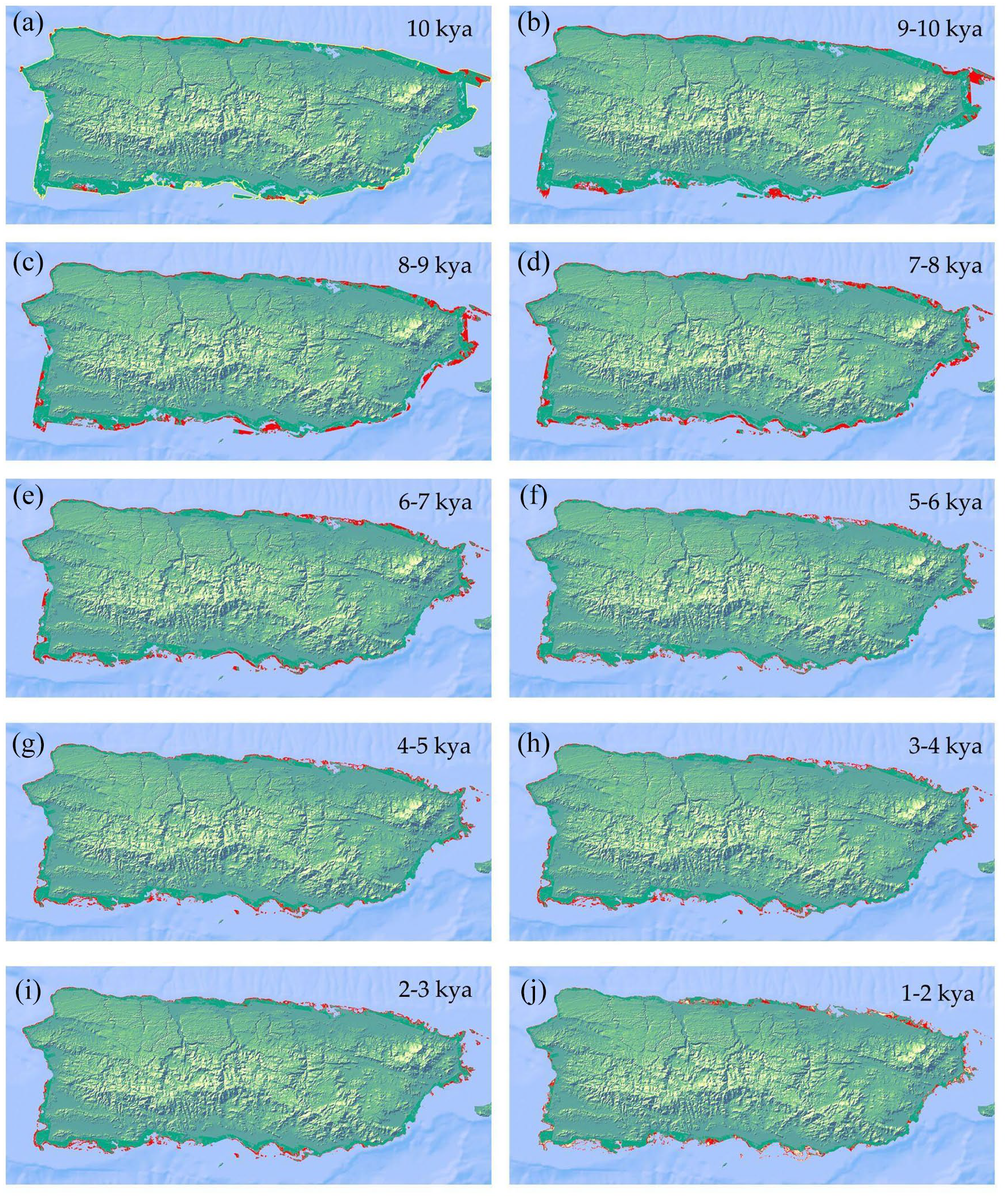
(a–j). Reconstructed ancient paleogeography of Borikén marking the areas impacted by rising RSLs between 10 and 0 kya. Time is shown at 1000-year intervals. The areas marked in red highlight the inundation of the coastline as it transformed supratidal zones either to intertidal or subtidal zones. For the 10 kya paleogeography surface, most areas impacted by Early Holocene inundation lie outside of the study area (outlined in yellow in panel A).
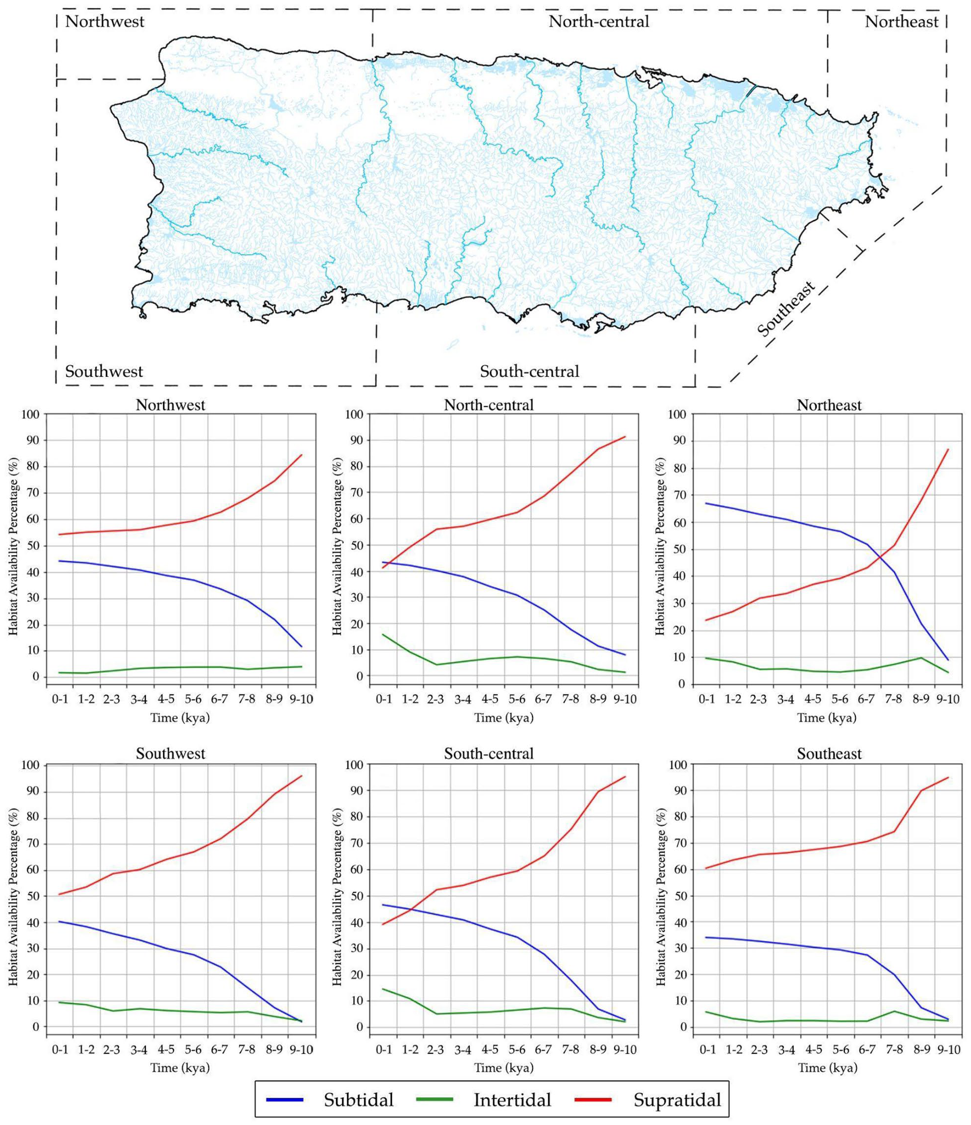
(Top) Map shows the geographic classifications of the shoreline based on Kaye (1959) and Barreto-Orta (2019). (Below) The graphs show the area percentage of shoreline transformation due to RSL rise. These graphs plot the changes in supratidal (above maximum tidal zone elevations, red), intertidal (between the maximum and minimum tidal zone elevations, green), and subtidal zones (below the minimum tidal zone elevations, blue). Values are presented as area percentages (% km2).
Northwest coast
Between 9 and 6 kya, RSL inundation rates converted 29.6% (25.9 km2) of supratidal areas into intertidal or subtidal areas of the northwest coast. Intertidal areas, however, experienced little change (−0.2%/−0.2 km2) during this time. These trends demonstrate that despite the high rates of RSLs inundation experienced during the Early and Middle Holocene, intertidal zone availability experienced little change prior to human arrival on the Northwest coast.
During the periods of human history, RSL change continued to inundate the northwest coast, albeit in decreasing rates. Though only 5.2% (5.4 km2) of this coastline was inundated between 5 and 0 kya, intertidal zone availability shrank by 55.1% (2.2 km2) and subtidal zone availability steadily decreased to 0.7% (0.73 km2). Intertidal zone availability decreased by 45.7% (1.9 km2) between 3–4 kya and 1–2 kya and continued to decrease in later periods. These later transformations of intertidal zone availability can be contextualized by considering the topography of the northwest coast. As this coastline is largely defined by a steep Tertiary limestone cliff. The shrinking intertidal zone availability and slowing growth of subtidal areas are likely the effect of the rising RSLs meeting the foot of this cliffside.
North-central coast
The coastal zone ratios of the north-central coast were moderately impacted by rising RSLs from 9–10 to 5–6 kya. RSL inundations during this time converted 31.7% (93.8 km2) of supratidal areas into intertidal and subtidal areas. Notably, intertidal areas expanded almost sixfold covering 7.1% (23.0 km2) of the coastline. The recent expansion of intertidal zone availability would have made this area favorable by the time of human arrival. The stabilizing RSLs continued to transform this coast through human occupation periods. Growth rates of subtidal areas slowly expanded at a steady rate of 2.1% (6.8 km2) per 1000 years reaching 35.7% (115.6 km2) of the coastline by 0–1 kya. Between 5–6 kya and 3–4 kya, intertidal areas decreased at a consistent rate of −1.8% (−5.8 km2/kya) reaching a minimum (4.1%/13.3 km2) by 2–3 kya. However, intertidal zone availability doubled covering 9.0% (29.2 km2) of the coastline by 1–2 kya and continued expanding reaching 15.6% (50.6 km2) by 0–1 kya. With these recent increases in intertidal areas, the north-central coast had the highest percentage of intertidal zone availability on the island during the later periods of early human occupation. Considering the coastal topography and local RSL curve can contextualize the coastal transformations and explain the transition from decreasing to increasing intertidal zone availability rates of the north-central coast. The large alluvial plains that characterize much of this coast are sediment-fed by several large rivers including the Rio Grande de Arecibo, Rio Grande de Manati, Rio Cibuco, Rio de La Plata, and the Rio Grande de Loiza. As the RSLs of the middle and Late Holocene stabilized, the coastal deposition likely shifted from an erosional to an accretionary environment as the sediment input from these rivers likely overtook the coastal erosion rates allowing for the formation of the alluvial plains, large swamps, and lagoons, that characterize this coastline.
Northeast Coast
The northeast coast experienced the highest impacts from rising RSL inundation rates between 9–10 kya and 5–6 kya. 45.1% (95.6 km2) of supratidal areas were converted to intertidal and subtidal areas. However, intertidal zone availability was not heavily impacted by early Holocene RSL rates as intertidal areas experienced only a slight overall increase (+0.2%/0.3 km2). The impacts of RSL stabilization on the northeast coast are comparable with other coastlines during human history. Subtidal areas steadily increased at a rate of 1.7% (3.4 km2) per 1000 years reaching 66.8% (134.0 km2) of the coast by 0–1 kya. Intertidal areas experienced slight expansion covering 4.4% (8.9 km2) of the coast 5–6 kya to 2–3 kya (+0.7%/1.5 km2). However intertidal areas rapidly expanded covering 8.2% (16.4 km2) of the coast by 1–2 kya, and to its highest availability 9.5% (19.1 km2) by 0–1 kya. This increase in intertidal zone availability can be explained by the local RSLs and coastal topography. With further stabilization of RSL rates during the Late Holocene, coastal deposition processes shifted from erosional to accretionary contexts. The expansion of intertidal zone availability can be attributed to the large swaths of recently submerged areas as the growth of offshore reefs protect the northern and eastern portions of the coast from wave and tidal erosion. In the east, the sediment input from Rio Fajardo may provide protections and accretionary contexts for favorable intertidal ecologies including the mangroves that characterize this portion of the coastline.
Southeast coast
The southeast coast was moderately impacted by rising RSLs between 9–10 kya and 5–6 kya. 27.6% (21.7 km2) of supratidal areas were converted into intertidal or subtidal areas and Intertidal zone availability was relatively stable as intertidal areas experienced a slight overall decrease (−0.1%/0.1 km2) prior to human arrival. Despite similar RSL impacts as other coasts during the Early and Middle Holocene, the southeast coast experiences the least amount of change in coastal zone availability during the Mid-Late Holocene. Subtidal area expansion slowed to a rate of 0.6% (0.5 km2) per 1000 years from 5 to 6 kya and 0 to 1 kya and intertidal area availability remained steady around 2.2% (1.8 km2). The intertidal areas experienced some expansion by 1–2 kya as these areas covered 3.2% (2.49 km2) of the coast and reached 5.7% (4.73 km2) by 0–1 kya. The coastline’s high presence of depositional environments can contextualize these transformations as the deltaic forelands of Rio Humacao, Rio Candelero, and Rio Guayanes convey the power of alluvial processes to transform southeast coastal zones. The sedimentation rates with the continuing yet slowing RSL rise likely obscure the coastal transformations for the 5–6 kya through 2–3 kya periods. The continued sediment input from alluvial processes as RSLs stabilized likely led to the intertidal zone availability and depositional environments that are present in the current coastline. The appearance of a shallow shelf toward the island’s southeastern tip and the increasing presence of coastal wetlands and mangroves support this interpretation.
South-central coast
Coastal areas of the south-central coast were moderately impacted by the rising RSLs between 9–10 kya and 5–6 kya. 37.6% (98.4 km2) of supratidal areas were converted to intertidal or subtidal areas. During this period, intertidal areas expanded threefold covering 6.6% (18.0 km2) of the coast. The south-central coast experienced similar trends as other coastlines through the periods of human occupation. Growth rates of subtidal areas slowed to 1.6% (4.5 km2) per 1000 years covering 46.4% (127.8 km2) of the coast by 0–1 kya. From 5–6 kya to 2–3 kya, intertidal areas shrank to 5.1% (14.0 km2) of the coast. However, intertidal zone availability doubled (10.9%/30.01 km2) by 1–2 kya and continued to expand covering 14.5% (39.9 km2) of the coastline by 0–1 kya. The recent increases in intertidal areas made the south-central coast’s intertidal zone availability comparable to the north-central coast. The expansion of intertidal areas and impact of the stabilizing RSLs are reflected in the topography and geomorphology of the coast. Like the southwest coast, the topography and depositional contexts of the south-central coast is shaped by the westerly longshore drifts. With RSL stabilization, sedimentation of the coast was deposited from the longshore currents and major rivers including the Rio Yauco and Rio Jacaguas. This low erosional context led to the appearance of major features that define this deltaic plain including sandy beaches and mangroves.
Southwest coast
The southwest coast was moderately impacted by the rising RSLs between 9–10 and 5–6 kya. 30.3% (117.1 km2) of supratidal areas were converted to intertidal or subtidal areas. Intertidal areas increased nearly threefold covering 5.6% (22.6 km2) of the coast during this time. At the time of human arrival, this coastline would have provided a high availability of intertidal zone ecologies, second only to the north-central coast. During periods of human occupation, subtidal area growth eventually slowed to 2.0% 7.9 km2) per 1000 years. Between 5–6 kya and 2–3 kya, this coastline provided relative stability and the highest intertidal zone availability as these areas remained consistently around 6.1% (24.1 km2) with slight fluctuations (±0.6%/±2.4 km2). Between 2–3 kya and 1–2 kya, intertidal areas experienced notable expansion covering 8.3% (33.4 km2) of the coast by 1–2 kya and 9.2% (36.8 km2) by 0–1 kya. The topography and geomorphology of the Southwest coast can better contextualize the expansion of intertidal zone availability and impact of local RSL trends during the late Holocene. Sediment input into this coast primarily comes from this region’s westerly longshore drift and northern sediment accumulation from the Rio Guanajibo. As RSLs began to stabilize during the Middle Holocene, these depositional processes and longshore drift begin to define the coast’s depositional context from 2–3 kya onward. These depositional environments resulted in the creation of the coast’s defining features including the broad shallow bank with fringing reefs, sand quays, beach plains, and mangroves.
Site location over their contemporaneous ancient coastline
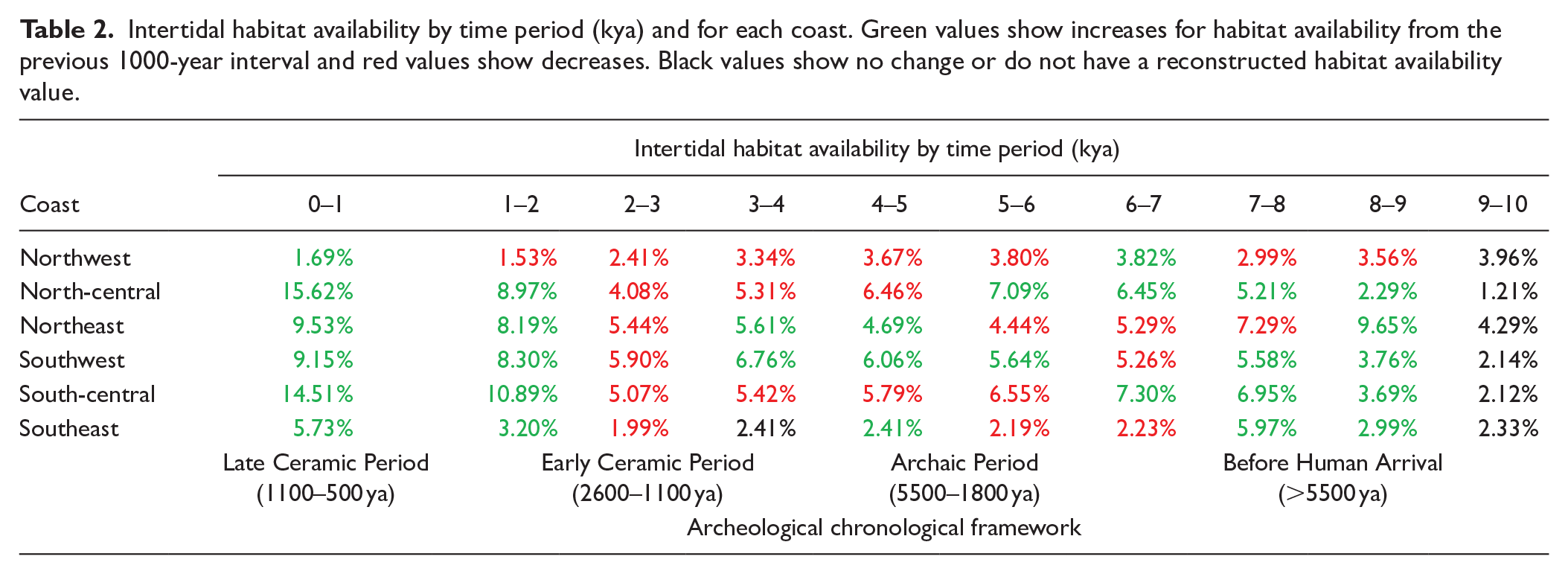
Altogether, 202 sites around the island were included in this study with several sites with continued occupation through multiple periods. We plotted the locations of the sites according to each cultural association over their contemporaneous coastlines. The resulting geographic and percent distributions are shown in Figure 6. As the number of sites for each cultural association varies, percentages were used to approximate site distribution by coastline (Table 2).
Intertidal habitat availability by time period (kya) and for each coast. Green values show increases for habitat availability from the previous 1000-year interval and red values show decreases. Black values show no change or do not have a reconstructed habitat availability value.
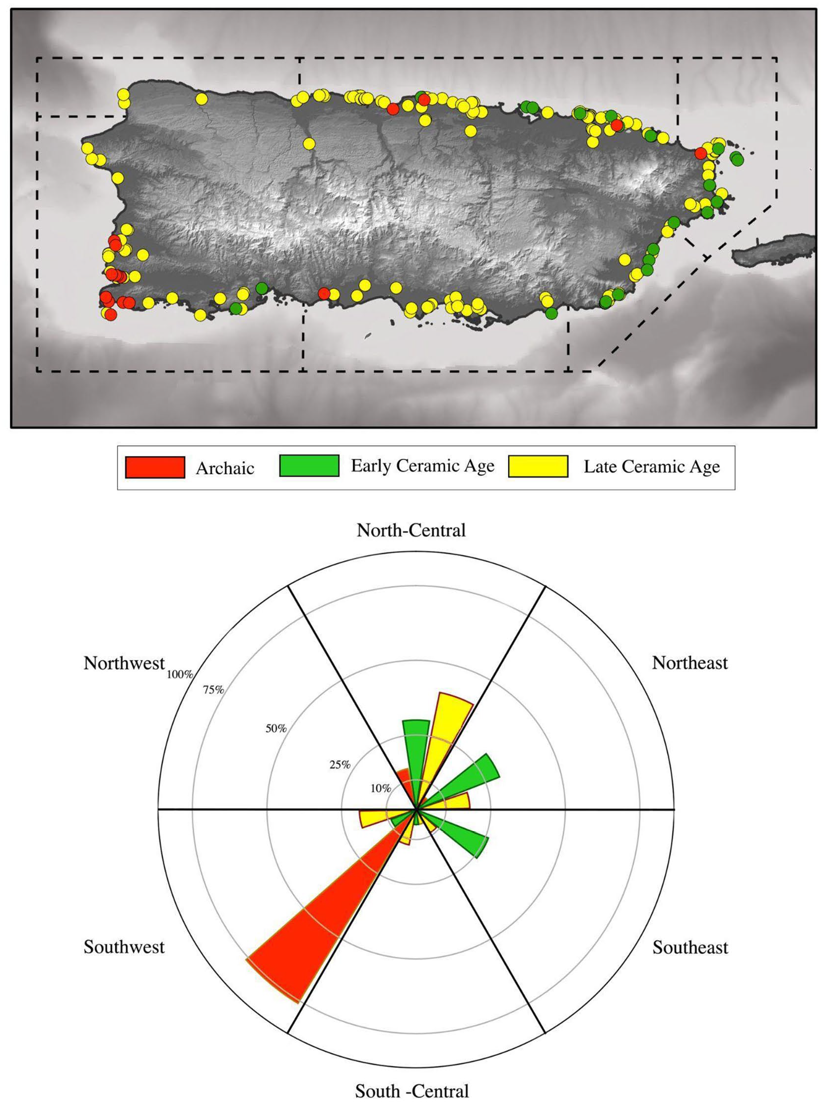
(Top) Geographic and (Bottom) Percent distributions of archeological sites by cultural classifications within 0–20 m amsl for the coastal areas of Borikén.
There are 21 registered coastal sites associated with Archaic Period materials. 76% of these sites were heavily clustered on the southwest coast with a lesser presence in the north-central (14%), northeast (5%), and south-central (5%) coasts. Sites reported to have ceramics of the Saladoid series served as a proxy for Early Ceramic Period sites. A total of 23 sites of this period were identified. They are heavily clustered on the north and eastern sections of the island, notably along the north-central (30%), northeast (30%), and southeast (26%) coasts. Fewer sites were present in the southwest (9%) and south-central (5%) coasts. Sites with pottery reported to be of the Ostionoid Series were interpreted to be proxy of the Late Ceramic Period. Due to the coarser resolution of the Late Ceramic classification, we discuss these archeological sites with the coastal transformations between 1–2 kya and 0–1 kya. There are a total of 173 sites of the Late Ceramic Period which constitute the largest number of sites in the database. Late Ceramic sites are predominantly located in the north-central coast (40%), followed by the southwest (19%), northeast (18%), and northeast (18%) with fewer sites present in the south-central (12%), southeast (9%), and northwest (2%) coasts.
Discussion
Our models of coastal environmental change and spatiotemporal distribution of archeological sites presented here have important implications for the continuing transformation of coastal environments in response to Holocene sea-level rise (Figures 4 and 5) and the distribution of human settlements across the coastlines (Figure 6). The coastal geographies of Borikén through the Holocene were unlike the modern geographies given that much of the coastline was inundated by the still rising sea-levels. Though the transformation of the Borikén coastlines by Early Holocene RSLs has been discussed elsewhere (see Rivera-Collazo, 2015a, 2019), our reconstructions show the impacts on intertidal zone availability by the stabilizing RSLs during the entire Holocene. Comparing the distributions of archeological sites with these reconstructed coastal topographies reveals the tendency of these sites to populate coastlines with stable or expanding availability of intertidal ecologies. We present our interpretations of past settlement strategies alongside the coastal transformation trends for the pre-Hispanic Indigenous periods of human activity below.
Archaic period Coasts (5–6 kya through 2–3 kya)
With human populations arriving to Borikén around 5 kya, early populations settled on areas with ample intertidal zones and stable rates of inundation, such as the southwest and north-central coasts. The earliest occupants would have witnessed the impacts of rising RSL which inundated roughly 2.1% of all shorelines, except for northeast shoreline, which experienced the greatest amount of loss as inundation during this period (10.4%). The southwest coastline presents the highest availability of intertidal zones, coinciding with the high concentration of Archaic Period sites.
Continuing RSL rise also transformed the availability of intertidal areas across the island. Intertidal areas decreased for south-central, northwest, and north-central coasts, remained stable for southeast and southwest coasts; and slightly expanded for the northeast coasts. Toward the end of this period, the movement of the ITCZ led to wetter conditions with higher potential of storms, increasing both the exposure of the intertidal zone to storm impact and the vulnerability of past societies. The change in potential risks and hazards experienced by the communities living during this time period could have influenced later expansion to other types of coastlines.
Early ceramic period Coasts (2–3 kya through 1–2 kya)
The Early Ceramic Period was a time of political transformations and coastal environmental change. Rising RSLs continued to stabilize, and subtidal zone growth continued for all coastlines. Given the northward movement of the ITCZ, wetter conditions contributed to higher sediment input from rivers during this time, creating the accretionary conditions for deltaic and alluvial plains. The coastal transformations of this period are largely characterized by the significant expansion of intertidal zone availability on all coastlines, except for the northwest coast, with some nearly doubling during this period. The southwest coast experienced the least amount of change and provided consistent ecological stability for the people residing there, especially those that still used assemblages typical of the Archaic Period.
The Early Ceramic Period is characterized by the arrival of the new communities of people that used Saladoid and Huecoid-style ceramics, whose sites show a heavy preference for the eastern portions of the island. The growing availability of intertidal areas, particularly on the eastern coasts, could have supported the subsistence and economic livelihood of these communities, providing vast resources to support fishing, hunting and collection, and raw resource acquisition for tool production. Wide intertidal zones also provide good buffers against the impact of storms, making coastlines safer for human presence (Dobson et al., 2020). Therefore, the combination of these characteristics of the landscape could have made these settings attractive for these communities to maintain supply and their long-distance exchange network (Bérard, 2013; Chanlatte Baik, 2013). The recent availability of intertidal zones and geographic orientation would have encouraged migrations around and between the islands without compromising their provisioning and/or livelihood strategies. On the eastern coast, settlements could be occupied longer as coastal settlements would not be immediately threatened by rising RSLs, provisioning strategies were not limited to the resources of a single coast, and inter-island networks could continue exchanging with other communities of people of the same social circles in Bieke and beyond, identified by the use of Huecoid and Saladoid ceramics (Bérard, 2013; Chanlatte Baik, 2013).
Moving away from a unilinear chronological framework, sites with Archaic materials could likely continue to reside on the north-central and northeast coasts, as well as other places around the islands, and interact with other Early Ceramic Period communities. It is plausible to then hypothesize that the local, regional, and long-distance social networks that define this and later periods developed from these inter- and intra- island migrations and contemporaneous availability of favorable ecologies. Continuing these expansions through the Late Ceramic Period, these abundant coastal environments could have invited a multicultural experience without negotiating resourcing strategies due to ecological pressure.
Late ceramic period Coasts (0–1 kya)
The coastal transformations of the Late Ceramic Period are defined by the continuing expansion of intertidal zone availability due to RSL stabilization, the formation of more accretionary contexts and possibly wetter conditions. The greatest intertidal expansion rates during this period affected the eastern, north-central, and south-central shorelines, creating new areas of both beach plains and coastal wetlands that are currently reflected in the island’s topography. With increasing intertidal ecologies and resources, pre-Hispanic Indigenous populations were not limited to individual coasts. The expanding coastal resources in the north-central, northeast, south-central, and southeast coast could have encouraged further expansion of coastal settlements during the period. Growing differences in coastal resource availability may have played a role in solidifying and expanding trade and exchange networks, and might have also had a role in the solidification of the more complex social structures observed during this period. Sites relating to this Late Ceramic Period, characterized by the presence of ceramics of the Ostionoid typological series and a heavy reliance on marine resources for subsistence, appear all around the coasts of the island with a significant presence in the north-central coast. Late Ceramic populations seem also to have expanded to coastlines without previous evidence of habitation such as the northwest. We interpret their presence as a participation in larger political networks, especially toward the west within the world of tainoness (Oliver, 2009; Rodríguez Ramos, 2010). This settlement distribution could have been facilitated by available coastal ecologies. Regional consolidation may still have been organized around geographic and environmental differences. It is important to highlight, however, that these statements are true for coastal settlements in Borikén. Analysis of subsistence practices for Late Ceramic inland sites suggests different practices for resource exploitation that might have had no relation to coastal ecologies (Rivera-Collazo and Sánchez-Morales, 2018). Higher archeological resolution is needed to examine the relationship between social organization and coastal resource availability.
Pre-hispanic indigenous responses to coastal transformations
Despite the heightened risks associated with living on coastal areas in contrast to inland places, coastal environments are attractive to human use because they provide stable settings for human terrestrial and marine provisioning strategies. The climatic conditions of the earlier centuries of the Archaic Period for Borikén generated less cyclone activity and less precipitation in comparison to the present, which means lower exposure to storms and other erosion-related impacts. While more research is needed to understand the settlement patterns of early settlers, the chronological data suggest that the picture we currently have of the Archaic Period is not of the initial exploration stages but of a later distribution of settlement on an already known place. The abundance of early sites on the southwest coast could have taken advantage of the stability and abundance of the intertidal areas for provisioning resources, and could also reflect a strategic control of other raw resources, in particular the regulation of access to chert and serpentinite outcrops in this area.
In time, RSL continued rising and the climate shifted to wetter conditions around 3.5 cal. BP. The higher exposure to coastal erosion, storms and low-land flooding can be expected to have impacted societies on the coasts during the Archaic - Early Ceramic Period transition. Other drivers of change that are expected to have impacted coastal ecosystem distribution include tectonism – that is, earthquakes, tsunamis, land subsidence or uplift – and climate-related hazards such as changes in frequency and intensity of hurricanes, sea surface temperature or accumulation of sediment runoff after frequent high intensity storms (Frölicher and Laufkötter, 2018; Ghazali et al., 2018; Johnson et al., 2018; Patrick et al., 2020). These drivers of environmental and geomorphological change have been recorded throughout Puerto Rico’s history (Doser et al., 2005; Lopez-Venegas,AM et al., 2008) such as during the Early Holocene (Piety et al., 2018; Prentice and Mann, 2005) and at the onset of the Medieval Warm Period (Schmitt et al., 2020). While these variables were not directly measured in this study, they have the potential to affect long-term changes in settlement patterns (Goff and Nunn, 2016; Salazar et al., 2022; Shtienberg et al., 2020) and should be searched for and measured in the future. Research has shown that the communities that used traditional Archaic material assemblages responded to their changing environments by altering habitation spaces, as recorded in Angostura, or by temporary site abandonment or relocation as observed in Maruca and Paseo Del Indio (Rivera-Collazo et al., 2015; Rodríguez, 1997, 2004).
With the expansion of intertidal areas due to the stabilizing RSLs, the availability of marine resources would have increased. Larger and more stable intertidal areas can be expected to provide stronger buffers against storm impact, thus mitigating the exposure of communities living on coastal zones. The decision of Early Ceramic Period groups to reside preferably on the eastern coasts could have initially been strongly influenced by strategies reflecting social and political relations with other places east of Borikén and the importance of inter-island maritime networks flowing on the sea in between the islands. However, the geomorphological and ecological characteristics of the east coast during that time period could have also played a strong role on the longevity and stability of these settlements with pottery of the Saladoid and Huecoid ceramic series (see Rivera-Collazo et al., 2021). More localized research efforts to examine the geomorphological contexts and specific ecological makeup of these areas is needed.
Late Ceramic Period communities experienced the impacts of slowing RSLs rise as the increasing alluvial sediment transport and deposition would have continued to support intertidal zone expansion during this period. The enhanced political complexity and the solidification and expansion of social networks toward the west of the Archipelago that define this period could have taken advantage of this stability and the intertidal ecologies supported by them.
Conclusion
The sub-meter rise and stabilization of Holocene RSLs transformed coastal environments of Borikén and influenced the settlement patterns of pre-Hispanic indigenous populations. In this paper, we present 10 paleogeographic surfaces of the island’s coast from 10 kya to the present and use these to contextualize the spatiotemporal distribution of coastal archeological sites to characterize human decision-making strategies amidst the coastal transformations of the different periods of human occupation. Our focus on the availability of intertidal ecologies and site distributions allows for a comprehensive examination of ecological and archeological patterns in the context of coastal environmental change and can address questions of pre-Hispanic Indigenous settlement strategies and resource availability. The datasets we used have severe limitations: we only have access to broad archeological classifications with limited reliable absolute dating, there have been many modern human impacts to the coastal geography, and we only look at a limited geographic coverage bounded by topographic elevation. These characteristics restrict our observations to hypotheses and suggestions rather than interpretations. However, the resolution of the archeological data is compatible with that of the environmental reconstructions. We are therefore confident that the conclusions generated from this analysis are a reliable first step to inspire more research to better understand settlement patterns in the context of coastal transformations. Our research demonstrates not only that climate-related environmental changes continued through pre-Hispanic periods, but also that these changes were very significant and their occurrence must be considered when attempting to understand settlement and resourcing decision-making strategies.
When considering the multicultural setting of the island, the settlement patterns of sites from different tempo-cultural classifications reflect not only unique environmental preferences, but different priorities over time. We contribute a broad understanding of coastal environmental changes that support diverse adaptation strategies. If archeological research wants to contribute to conversations about past social vulnerability to climate change, it is imperative that we also reconstruct the conditions influencing the specific exposure, sensitivity and adaptive capacity of each social context, within its contemporary climate and environmental processes. Seeking a stronger consideration of local factors will allow further characterization of the unique histories, ecologies and human-coastal interactions that influenced the experiences of the inhabitants on these coastlines.
Footnotes
Acknowledgements
We acknowledge that we teach and live in the unceded traditional lands of the Kumeyaay/Kumiai people whom we hope to learn from and give back to. Isabel Rivera-Collazo and Marisol Rodríguez-Miranda are grateful to work in their homeland on the island of Borikén. All together, we are grateful to work with the wider territories of the Taino/Jibaro/Borikua and Kalinago peoples and of the descendants of all those peoples of the Caribbean brought together by complex historical processes that link their identities to our islands and our sea. Many thanks to editors, Alastair G. Dawson and Gill Oliver, and the anonymous reviewer for their guidance in the review process and their constructive feedback in earlier versions of our paper.
Data availability statement
Funding
The author(s) received no financial support for the research, authorship, and/or publication of this article.