
Abstract
This study aims to explain the influence of sediments and landforms of postglacial and loess landscapes of Europe on processes forming meandering and anabranching rivers. Based on a literature review, sedimentary architecture, types and grain-size of deposits, and channel planform changes since the Late Pleniglacial were collected for extensive set of European rivers. These data were used to create a conceptual model explaining the evolution of meandering and anabranching rivers in both types of landscape. The present study shows that the inheritance of glacial and fluvioglacial landforms and sediments, and loess formation, influence types of processes forming anabranching and meandering rivers. Point bar accretion formed meandering rivers in postglacial zone whereas oblique accretion dominated in loess areas. Anabranching rivers of postglacial zone evolved through the formation of crevasse channels and meandering anabranches. Anabranching rivers of loess zone formed sustained bifurcations. Postglacial and loess rivers reacted differently to increased deposition and humidity in the Late-Holocene. Meanders of postglacial zone formed channel bars owing to increase in stream power and sediment load. In cases of flow energy decrease, and sustained upstream sediment delivery, they turned into anastomosing rivers. Anabranching rivers in ice-marginal valleys maintained its courses until hydro technical works in the 19th century. Low-energy meandering rivers of loess areas became wetlands owing to deposition of silts. High-energy meandering and anabranching rivers maintained the planforms throughout the Holocene. These findings need to be refined by detailed studies on the evolution of rivers in subarctic zone, and large rivers of Europe.
Keywords
Introduction
Meandering and anabranching rivers were the most common types of channel planforms in Europe in the Late Pleniglacial (~30,000–14,700 cal. BP), Late Glacial (14,700–11,700 cal. BP), and Holocene. Traces of these river systems have been preserved in sedimentary record of paleochannels and floodplains, especially in river valleys where a decreasing trend of stream power, aggradational nature of river systems, and successively decreasing channel belts favored such a preservation (Słowik et al., 2022). Despite extensive studies on river planform changes (see Supplemental Materials for detailed review), knowledge about processes forming channel patterns, and connections between these processes and available sediments and landforms remains incomplete.
The main goal of the present study is to determine the influence of sediments and landforms on processes forming meandering and anabranching rivers in postglacial and loess landscapes of Europe. The existing knowledge is used to develop a conceptual model describing processes influencing the evolution of these rivers, and identifying causes of the observed differences. The following research tasks were realized to develop the model: (i) to identify types of floodplain sedimentary architecture of European postglacial and loess meandering and anabranching rivers, (ii) determine properties of sediment grain-size for both types of areas and rivers, (iii) identify processes influencing the evolution of these rivers in both types of landscapes, and (iiii) compare changes in channel planforms of rivers in postglacial and loess zone in response to climate and human-impact induced changes. The main hypothesis verified by the present study is that sorts of available sediments and landforms conditioned the types of processes that influenced the evolution of meandering and anabranching rivers in postglacial and loess landscapes of Europe. The sedimentary and geomorphological inheritance also influenced a diversity in rivers’ reactions to human actions and climate changes in the Late-Holocene.
First, the types of sedimentary architecture of floodplains formed by meandering and anabranching rivers in postglacial and loess areas of Europe are identified. This is followed by the analysis of differences between sediments forming postglacial and loess river floodplains. Next, the model of the evolution of anabranching and meandering rivers of postglacial and loess areas of Europe is proposed. Differences in reactions of rivers to coupled influence of increase of humidity and human impact in the Late-Holocene, and gaps in the existing knowledge, are identified and discussed.
Materials and methods
The geological and geomorphological literature on the evolution of anabranching and meandering rivers of Europe was studied taking into account the types and age of channel planforms, discharge and stream power, channel and floodplain sedimentary structures, and types of sediments forming paleochannels and floodplains. A spatial extent of the Riss (Warthanian, Dnieper) glaciation was used to delineate the border between postglacial and loess zone (Figure 1). The aim was to identify two types of rivers:(i) formed in glacial and fluvioglacial deposits inherited from the two last glaciations’ period and (ii) reworking loess sediments formed at the forefront of the glaciations. The literature review focused on river valleys formed in glacial and fluvioglacial sediments, and cut in loess deposits. Possible transitional types (i.e. valleys formed in postglacial sediments overlain by a loess layer) were not discussed here.
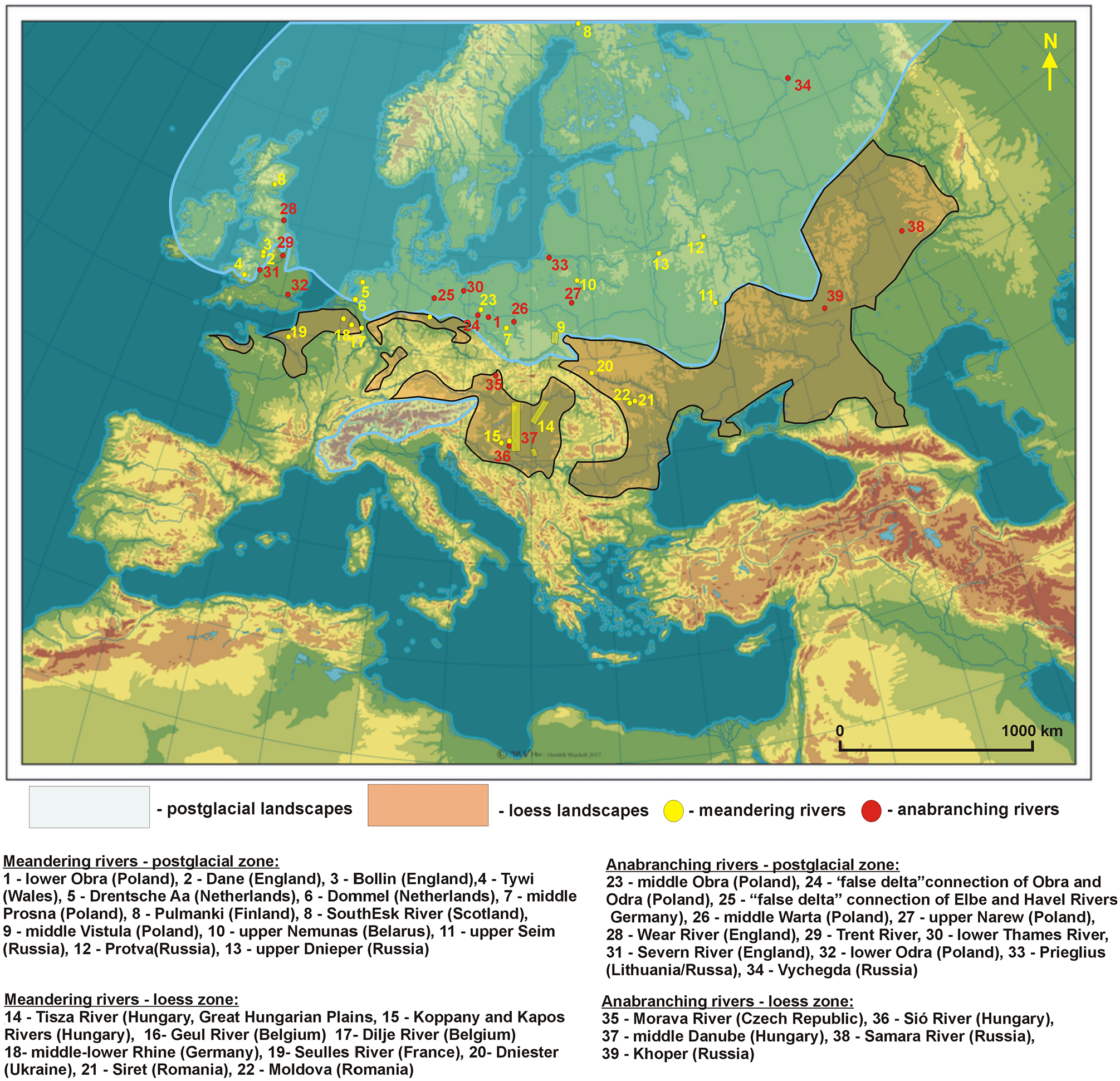
Postglacial and loess landscapes of Europe, and list of rivers analyzed in the present study.
The present review includes rivers representing discharges from 8.0 to 1160.0 m3 s−1, and stream power from 0.5 to 170.0 W m2 (see Table 1). This allowed to compare the evolution of rivers characterized by a wide range of flow energy values. Detailed information regarding the number of rivers, represented volumes of their discharge and stream power (Supplemental Tables S1–S3), amount of radiocarbon and OSL dating, grain-size data, and definitions of channel planforms is shown in Supplemental Materials. Terms “Late Pleniglacial” and “Late Glacial” refer to 30,000–14,700 cal. BP and 14,700–11,700 cal. BP, respectively. The Late Pleniglacial is comparable to duration of the Late Weichselian period (see table with subdivision of the Late Pleistocene in e.g. van Huissteden and Kasse, 2001). Terms “Early Holocene,” “Middle Holocene,” and “Late-Holocene” used in the present study refer to periods 11,700–8200 cal. BP, 8200–4200 cal. BP, and 4200 cal. BP–present, were determined by Walker et al. (2018).
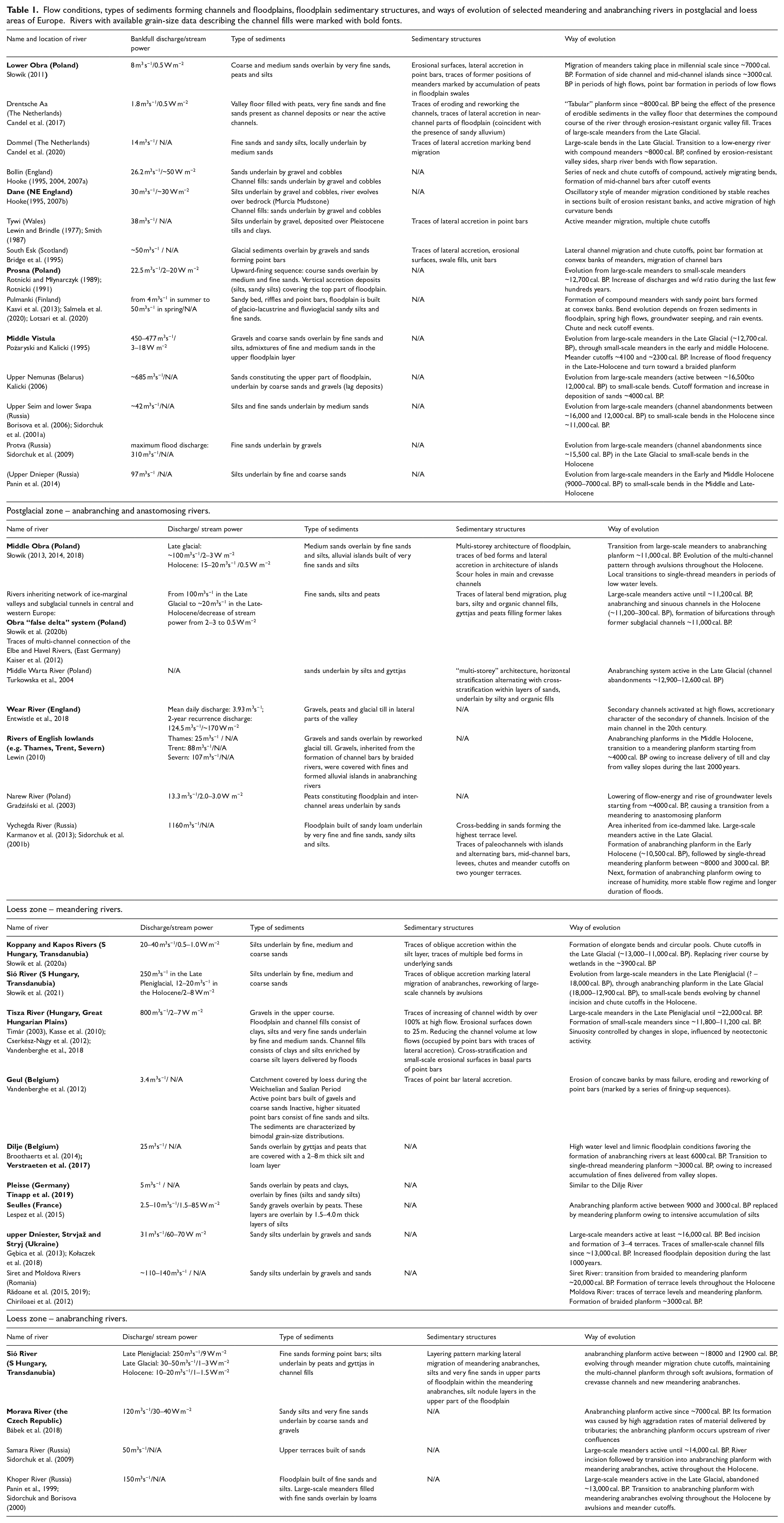
Flow conditions, types of sediments forming channels and floodplains, floodplain sedimentary structures, and ways of evolution of selected meandering and anabranching rivers in postglacial and loess areas of Europe. Rivers with available grain-size data describing the channel fills were marked with bold fonts.
A model describing the evolution of anabranching and meandering rivers of Europe was created using the available grain-size, paleochannel and floodplain sedimentary structure, and sediment dating data. The model consists of two parts: examples of the influence of postglacial and loess sediments and landforms on the rivers’ evolution, and a conceptual part describing conditions for channel planform transitions in both types of landscapes. The model was created using the following assumptions:
- inherited postglacial landforms influence the evolution of rivers by the formation of bifurcations.
- inherited types of sediments in both types of landscapes condition the grain-size of deposits available for erosion and transport for both types of river planforms
- coupled influence of human impact and increase in climate humidity in the Late-Holocene produced different reactions of meandering and anabranching rivers in both types of landscapes.
- geomorphic states of rivers proposed in the model can be treated as continuous, that is such that under a set of changing sediment delivery and hydrological conditions an anabranching river planform may evolve into a single-thread meandering river, and the opposite transition is also possible.
Sedimentary architecture of meandering and anabranching river floodplains in postglacial and loess areas
Meandering rivers – postglacial landscape
Ridge and swale floodplains
This group can be classified as lateral migration rivers with scrolled floodplains distinguished by Nanson and Croke (1992). Rivers of postglacial lowlands of Europe inherited deposits from the activity of melt-out waters of the last glaciation. The stream power of these rivers amounts from 2.0 to 20.0 W m−2 in sand bed rivers to 30.0–50.0 W m−2 in gravel bed rivers (Figure 2a and b). The sedimentary architecture of meandering rivers evolving in postglacial landscapes is characterized by distinct traces of bend migration, point bar formation and cutoffs (Figure 2). The structure of point bars is defined by upward-fining sequences and traces of lateral accretion. The ridge and swale topography contains a record of lateral migration of river bends (cf. Bridge et al., 1995; Hickin, 1974; Leclerc and Hickin, 1997; Słowik, 2011).
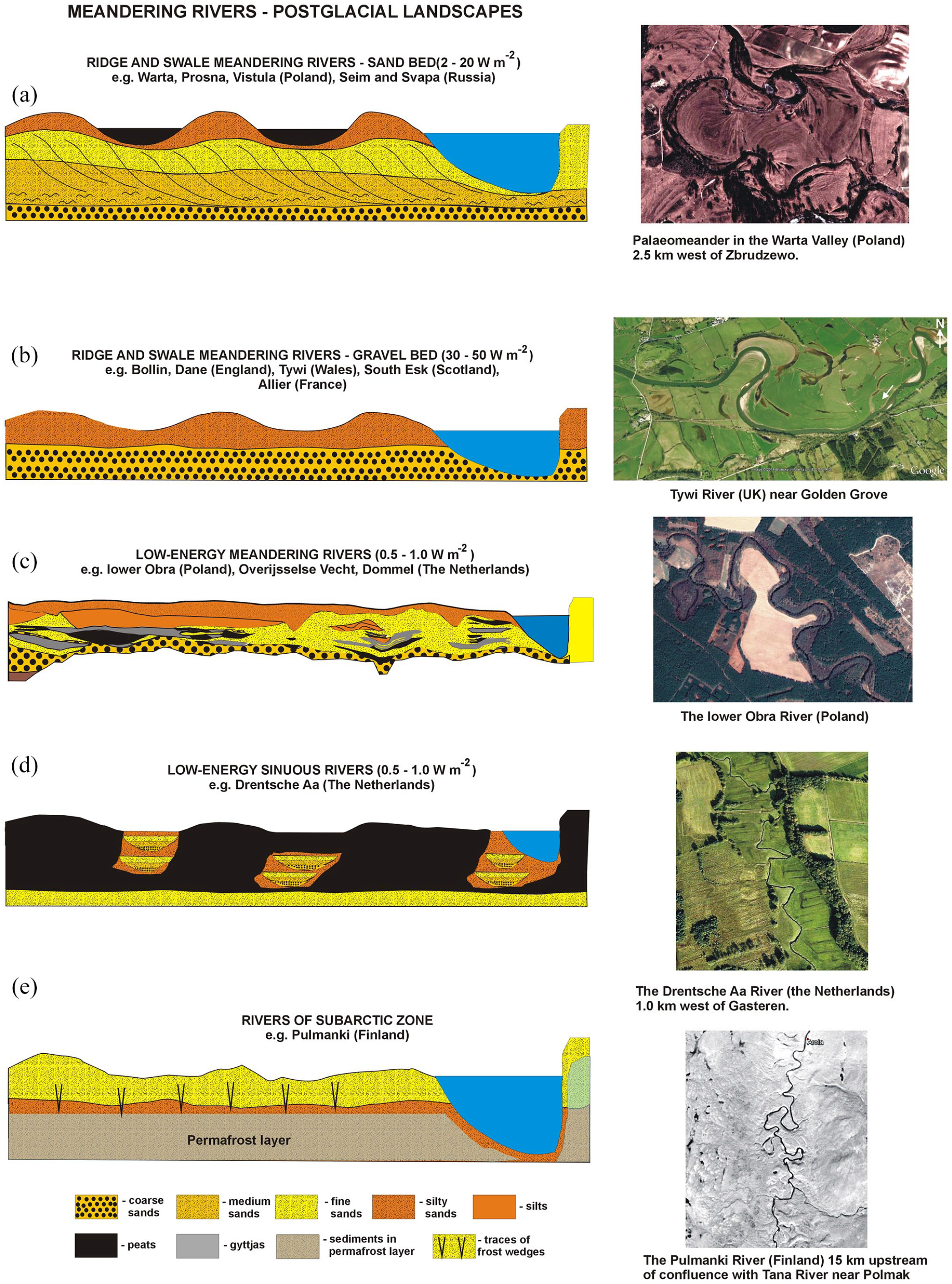
Types of sedimentary architecture of alluvial fills formed by meandering rivers in postglacial areas. The geological sections were drawn based on data presented by (a) Rotnicki and Młynarczyk (1989), Borisova et al. (2006), (b) Bridge et al. (1995), (c) Słowik (2011), Candel et al. (2018, 2020), (d) Candel et al. (2017), (e)Vandenberghe (2001), Lotsari et al. (2020).
In periods of high flows, mid-channel bars appear in the river course (cf. Luchi et al., 2010; Słowik, 2011). Erosional surfaces, marking reworking of channels and adjacent floodplain by flood events occur in bottom part of the swales; however, traces of higher-magnitude events may be marked in the architecture of the whole inner bank of meanders (cf. Bridge et al., 1995; Słowik, 2011, 2016b). The above features are characteristic of a number of valley fills formed by meandering rivers (e.g. the Prosna River, Poland – Rotnicki and Młynarczyk, 1989; the middle Vistula River, Poland – Pożaryski and Kalicki, 1995; the Warta River, Poland - Gonera and Kozarski, 1987; the upper Seim and lower Svapa Rivers, Russia – Sidorchuk et al. (2001a), Borisova et al. (2006); Protva River, Russia – Sidorchuk et al., 2009; upper Dnieper (Russia) – Panin et al., 2014). Meander cutoffs are the result of series of high flows (cf. Hooke, 1995), and are marked in floodplain sedimentary architecture by paleochannels filled with gyttjas and peats. They are sealed by plug bars with traces of eroding and reworking by high flows after meander cutoff (cf. Hooke, 2007a; Smith, 1987; Słowik, 2016b; Toonen et al., 2012). Ridge and swale floodplains are also shaped by high-energy gravel-bed rivers, situated in uplands (e.g. the Tywi River, Wales – Lewin and Brindle, 1977; Smith, 1987, 1989; the Allier River, France – Blom, 1997; the Bollin and Dane Rivers, England – Hooke (1995, 2004, 2007b, 2007a); South Esk River, Scotland – Bridge et al., 1995). The floodplains of these rivers consist of silts underlain by gravels and cobbles (Figure 2b).
Low-energy meandering rivers (0.5–1.0 W m−2)
Low-energy rivers evolve through the formation of compound meanders with sharp bend apexes (e.g. the lower Obra River – Słowik, 2016b; the Dommel River, Netherlands – Candel et al., 2020;). They are characterized by low stream power (0.5–1.0 W m−2). very fine sands and fine sands the floodplains (the Obra River, Poland – Słowik, 2011, 2016b; Overijsselse Vecht, the Netherlands – Candel et al., 2018; the Dommel River, the Netherlands – Candel et al., 2020; Figure 2c). Floodplain deposits fine upwards (cf. Słowik, 2016a). Similar to ridge and swale floodplains, sedimentary architecture (Figure 2c) is characterized by fills of organic sediments marking the migration phases of meander bends. The formation of the floodplains in valleys formed by low-energy meandering rivers takes place in a millennial time scale (cf. Słowik, 2011). There are also low-energy sinuous rivers formed by oblique aggradation in conditions of peats accumulation of on the floodplain (e.g. the Drentsche Aa River, the Netherlands – Candel et al., 2017; Figure 2d). They evolve through vertical aggradation combined with lateral movement of the river bed, especially in places where erodible sediments are available. These rivers form tabular, sinuous planforms with organic floodplain and sandy channel fills (Candel et al., 2017).
Meandering rivers in subarctic zone
The evolution of meandering rivers in subarctic zone is understudied. Studies carried out in the Pulmanki River Valley (Finland – e.g. Kasvi et al., 2013; Lotsari et al., 2020) show that the floodplains of subarctic rivers can be formed in glacio-lacustrine deposits inherited from sedimentation in ice-dammed lakes, and fluvioglacial sands left by melt-out waters of the last glaciation (Figure 2e). These rivers form compound bends evolving through chute cutoffs (e.g. the Pulmanki River, Finland). Their evolution is conditioned by permafrost (e.g. the Tana River, Finland/Norway; Dukers, 2002) that increases the resistance river banks and/or the presence of cohesive sediments. The floodplain architecture is also characterized by the presence of frost wedges (Vandenberghe, 2001). River bed lateral migration causes degradation of permafrost layer owing to the friction and heat exerted by the water on the permafrost layer (Vandenberghe, 2001).
One of few studied rivers from the subarctic zone is the Pulmanki River (Finland). The floodplain is built of sandy silts and clayley silts overlain by sands (cf. Lotsari et al., 2020; see also Figure 2e). The modern Pulmanki River conveys sandy bedload (D50 = 0.2–3.0 mm) enriched by suspended load that measures 180–280 mg dm−3 during high flows in spring. The dynamics of the meanders depends on seasonal changes in flow (cf. Kasvi et al., 2013), and interactions between sediments frozen in winter period, influence of high-flow events caused by snowmelt, rain events and related mass failures, and groundwater seeping (cf. Lotsari et al., 2020).
Meandering rivers – loess landscape
Low-energy meanders (0.5–1.0 W m−2)
Floodplains of low-energy meandering rivers evolving in loess area of central Europe are built of silts underlain by fine and coarse sands (e.g. Kapos and Koppány River, Hungary – Lóczy and Dezső, 2013; Słowik et al., 2020a; Figure 3b). The stream power of these rivers reaches 0.5–1.0 W m−2. The deposition of fines commenced through oblique accretion (see Figure 3b, and Słowik et al., 2020a). Floodplain architecture of low-energy meandering rivers of western Europe, that is the Dilje River (Belgium – Broothaerts et al., 2014), the Seulles River (France – Lespez et al., 2015), and the Pleisse River (Germany; Tinapp et al., 2019) is similar to the Kapos and Koppány Valleys. Similar to loess rivers of Hungary, the activity of meandering planforms is associated with top layer of the floodplains built of silts and clays (see Figure 3b). The main difference is a layer of gyttjas and peats deposited between the sands and silty deposits (Figure 3c). These are the traces of limnic conditions and water logging, favoring the formation of shallow floodplain lakes. The layer of gyttjas and peats represents traces of anabranching rivers active in these valleys between 9000 and 3000 cal. BP (see subsection about anabranching rivers in this paper, and geological sections shown by Broothaerts et al., 2014; Lespez et al., 2015; Tinapp et al., 2019). According to classification proposed by Nanson and Croke (1992) this group of rivers belongs to low-energy cohesive floodplains.
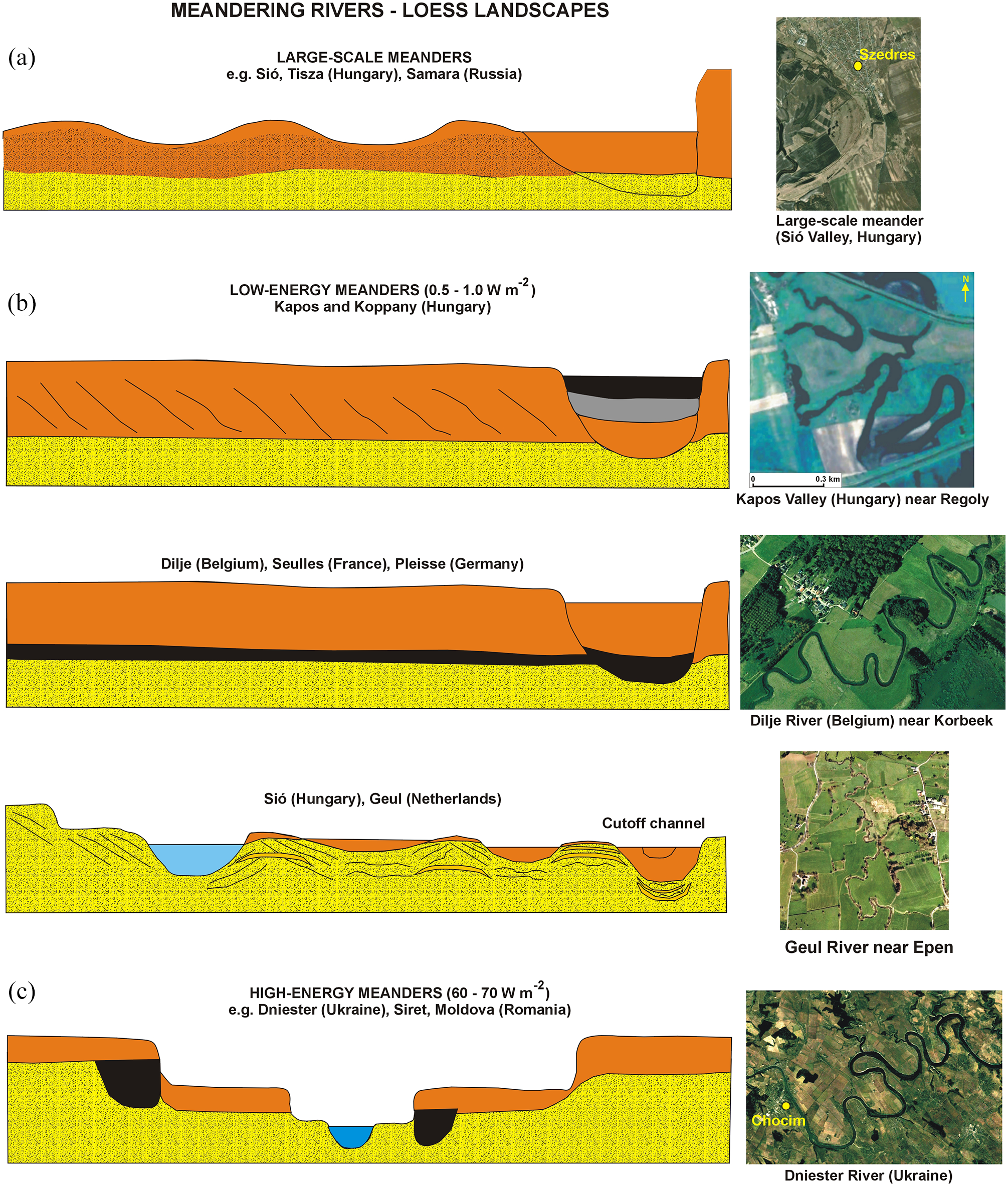
Types of sedimentary architecture of alluvial fills formed by meandering rivers in loess areas. The geological sections were drawn based on data presented by (a) Vandenberghe et al. (2018), Sidorchuk et al. (2009), (b) Słowik et al. (2020a), Broothaerts et al. (2014), Lespez et al. (2015), Tinapp et al. (2019), Słowik et al. (2021), Vandenberghe et al. (2012), (c) Gębica et al. (2013), Rădoane et al. (2015), Rădoane et al. (2019).
In the Geul River Valley (Belgium), point bars are built of sandy silts underlain by coarse sands and gravels (Vandenberghe et al., 2012). Inactive point bars are situated within a terrace level. Point bars situated at the floodplain level are built of fines enriched by admixtures of coarse deposits with traces of eroding and reworking by high flows. The sediments forming the point bars have layering pattern marking lateral migration of the river bed (cf. Vandenberghe et al., 2012). This is similar to the architecture of small-scale meanders active in the Sió River Valley throughout the Holocene (cf. Słowik et al., 2021). The Sió River bed incised and reworked medium and coarse sands situated below the fines originating from the adjacent loess hills. The meanders evolved through the formation of cutoffs, mid-channel bars and islands in periods of high flows (see Figure 3b and examples of the floodplain architecture in Słowik et al., 2021).
High-energy meanders (60.0–70.0 W m−2)
River floodplains of high-energy meandering rivers of loess zone are built of silts underlain by sands and gravels (e.g. the Dniester River, Ukraine – Gębica et al., 2013; Gębica and Jacyšyn, 2013; the Siret and Moldova Rivers, Romania – Chiriloaei et al., 2012; Rădoane et al., 2015, 2019). The Dniester River evolved through lateral migration of bends and river bed incision – there are at least three terrace levels formed since the Late Pleniglacial (~30000–14,700 cal. BP) (Figure 3c). The Dniester has been a meandering river since the Late Glacial (Gębica et al., 2013; Kołaczek et al., 2018). Its stream power amounts to 60.0–70.0 W m−2. Gębica (2013) provided data showing that there are remains of channels from the turn of the Late Glacial and Late-Holocene, covered by a 2–4 m thick layer of younger sediments constituting river terraces. Based on sediment dating conducted by Gębica (2013) in the Dniester, Strviaż and Stryj River valleys (Ukraine), the formation of terrace levels took place at ~11,400, 5500, and 1250 cal. BP. The increase in a deposition of overbank fines was noted during the last 1000 years owing to coupled influence of human impact (deforestation), and appearance of flooding phases (Gębica et al., 2013). The Siret River formed meanders 20,300 cal. BP (Rădoane et al., 2015). The Moldova River turned from a meandering to braided planform ~3000 cal. BP (Rădoane et al., 2019).
Anabranching rivers – postglacial landscape
Anabranching rivers in ice-marginal valleys (0.5–3.0 W m−2)
Anabranching rivers were active since the Late Glacial. In central Europe, they evolved in 5–10 km wide ice-marginal valleys inherited from activity of melt-out water of the last glaciation (cf. Toucanne et al., 2009). These rivers are related to the group of “anastomosing rivers with inorganic floodplains” identified by Nanson and Croke (1992). Their floodplains contain organic sediments (present in channel fills, and in the floodplains as inserts of organic layers). However, the content of the organic deposits is small in comparison with anastomosing rivers. Stream power of these rivers successively decreased from 2.0 to 3.0 W m−2 in the Late Glacial to ~0.5 W m−2 in the Holocene (cf. Słowik et al., 2022). The floodplain sedimentary architecture is multi-storey (Figure 4a). Coarse and medium sands are overlain by a 0.5 m thick layer of silty sands and silts (e.g. the middle Warta, Poland – Turkowska et al., 2004; the middle Obra, Poland – Słowik, 2014). Channel fills are built of fine sands, silts and peats (Figure 4a). The planform of anabranches formed in sands is meandering (Słowik, 2018; see also Figure 5). The floodplain architecture records traces of layering pattern marking the lateral migration of the channels. The new anabranches are formed through the formation of crevasse splays marked in the floodplain architecture by foreset facies and scour holes (Figures 4a and 5). A similar type of anabranching floodplains is present in postglacial areas of north-eastern Europe (the Vychegda River, Russia – see Figure I in Supplemental Materials, available online). Its floodplain is built of sandy loams underlain by very fine sands, and is underlain by clays and loams deposited in an ice-dammed lake (Sidorchuk et al., 2001b). The modern Vychegda River develops a complex system of alluvial islands with one main channel and two-three secondary channels. There are also “meander-like” sections with traces of lateral migration of secondary channels (see Supplemental Figure I, available online).
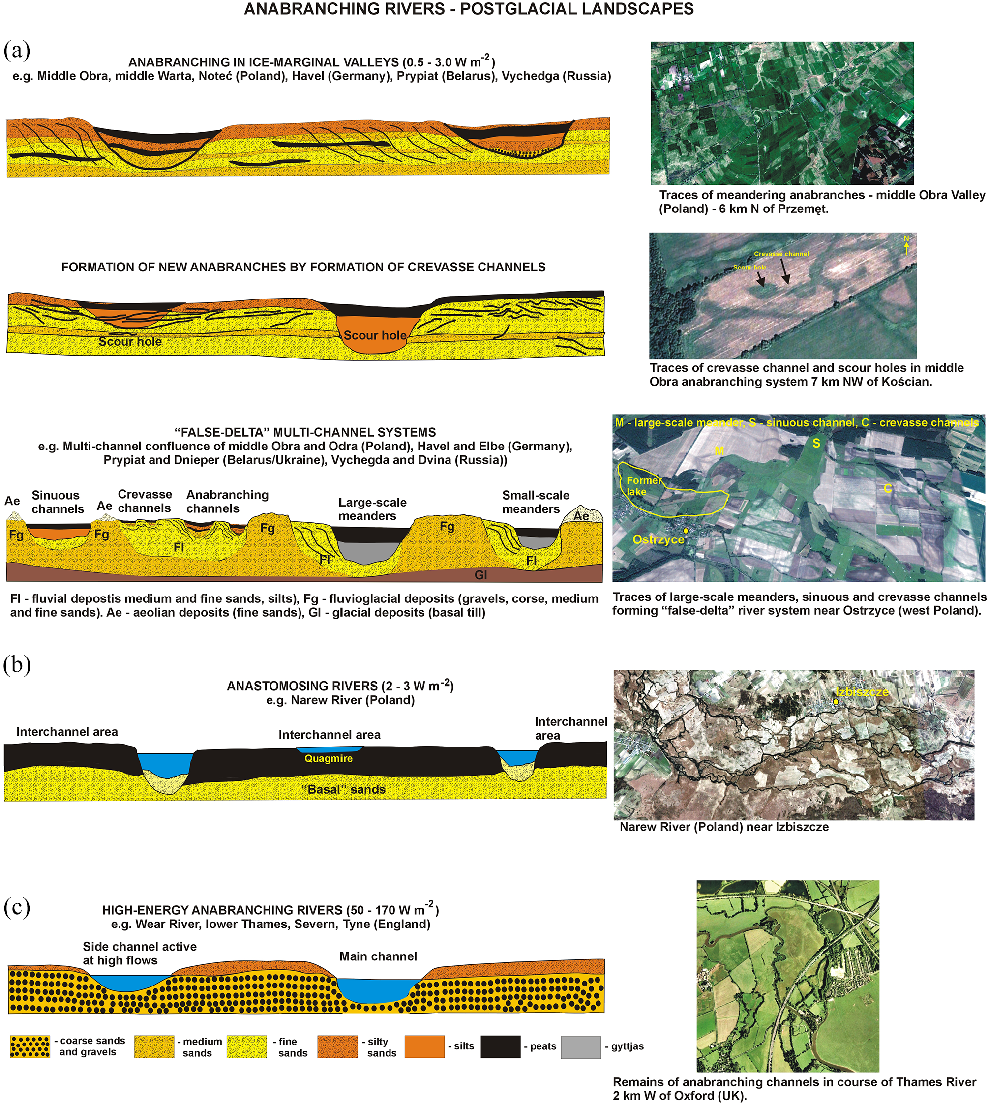
Types of sedimentary architecture of alluvial fills formed by anabranching rivers in postglacial areas. The geological sections were drawn based on data presented by (a) Słowik (2014), Słowik et al. (2021), Turkowska et al. (2004), Sidorchuk et al. (2001b), (b) Gradziński et al. (2003), (c) Lewin (2010), Entwistle et al. (2018).
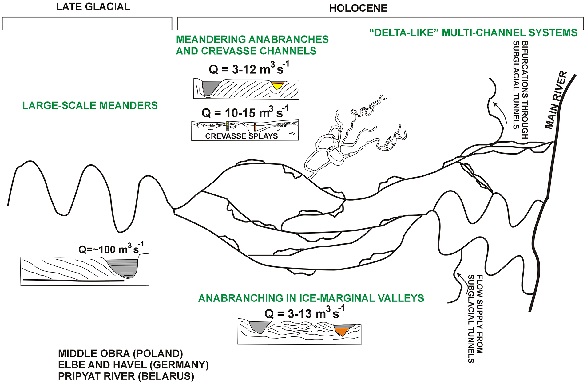
Main elements of evolution and structure of river planforms evolving in ice-marginal valleys based on data from Słowik (2011, 2013, 2014) and Słowik et al. (2020b).
“False-delta” multi-channel systems are a unique type of anabranching rivers. They can be defined as multi-channel confluences of anabranching rivers evolving in ice-marginal valleys, and major rivers flowing to the Baltic Sea, North Sea and Arctic Seas. Traces of these multi-channel systems can be found in central (the confluence of the middle Obra and Odra Rivers, Poland – Słowik et al., 2020a), western (confluence of the Havel and Elbe Rivers, Germany – Supplemental Figure II, available online), and eastern Europe (confluence of Pripyat and Dnieper Rivers, Belarus/Ukraine – Supplemental Figure III, available online; confluence of the Vychegda and Dvina Rivers, Russia – Supplemental Figure IV, available online). “False-delta” systems are characterized by a variety of channel planforms: large-scale meanders active in the Late-Glacial, replaced by anabranching, sinuous and crevasse channels in the Holocene (cf. Słowik et al., 2020a) (Figures 4a and 5). Particular “branches” of the “false-delta” systems are separated by fluvioglacial and aeolian landforms (Figure 4a, see also fig. 8 in Słowik et al., 2020a). The floodplains of false delta systems are characterized by a number of sedimentary structures, that is layering pattern occurring within the inner banks of large scale meanders and meandering anabranches, traces of bedforms, and erosional surfaces marking eroding and working of channel bed and floodplain (Słowik et al., 2020a).
Anastomosing rivers (2.0–3.0 W m−2)
Anastomosing rivers are a subclass of anabranching rivers (Nanson and Knighton, 1996). They are characterized by organic floodplains (class C2a identified by Nanson and Croke, 1992), stable channels with little or no lateral migration, and the presence of interchannel areas and/or floodbasins between the channels (Gradziński et al., 2003; Makaske, 2001; Figure 4b). Their stream power amounts to 2.0–3.0 W m−2. The upper course of the Narew River (Poland) represents a unique type of the modern anastomosing planform (Gradziński et al., 2003). The river evolves in the valley inherited from the Warthanian glaciation. The river valley is from 1 to 3 km wide. The widest valley sections (~3 km of width) were formed owing to the presence of “dead ice” blocks (Falkowski, 1970 in: Gradziński et al., 2003). The floodplain consists of a number of flat interchannel areas. They are built 4–5 m thick layer of peats with inserts of organic muds underlain by “basal sands” that could have been deposited by an older fluvial system (Gradziński et al., 2003 and references therein). Quagmires (a system of small vegetated pools) are present within the interchannel areas (Gradziński et al., 2003).
High-energy anabranching rivers (50.0–170.0 W m−2)
The floodplains of high-energy anabranching rivers are built of gravels and sands (e.g. the Wear River, England – Entwistle et al., 2018; Figure 4c). They evolve through the activation of secondary channels in periods of high flows. The main and secondary channels are divided by vegetated gravel islands (Entwistle et al., 2018; Wishart et al., 2008). Fines originating from sediment delivery from the surrounding areas are deposited on top of the gravel floodplain (Wishart et al., 2008). The coarse sediments are overlain by silty sands and silts also in other river valleys from English Lowlands (e.g. the lower Thames River, Trent River, Severn River, Tyne River). These rivers had been anabranching, with gravel islands, reed beds in old channels, and swampy interchannel areas, prior to intensive siltation during the last 2000 years (cf. Lewin, 2010), intensified by development of mining industry during the last 200 years (Macklin and Lewin, 1989; Wishart et al., 2008). The bottom parts of their floodplains consist of sands and gravels, similar to the Wear River valley. The coarse sediments are inherited from the activity of gravel bars in courses of braided rivers in the Pleistocene.
Anabranching rivers – loess landscape
Low-energy anabranching rivers (1.5 to max. 10.0 W m−2)
The evolution of these rivers is understudied. The case investigated in most detail is the Sió River valley (Hungary). An anabranching system with meandering anabranches was active there between 18000 and 12900 cal. BP (Słowik et al., 2021). This river planform was characterized by stream power of 2.0–3.5 W m−2. The floodplain is built of silts, sandy silts and fine sands (Figure 6a). Its internal structure shows a layering pattern marking the lateral migration of meandering anabranches. The paleochannels are filled with gyttjas and peats overlain by a 2 m thick layer of silts (Figure 6a). Low-energy anabranching rivers were also active in river valleys of western Europe between 9000 and 3000 cal. BP (e.g. the Seulles River, France – Lespez et al., 2015; Dilje River, Belgium – Broothaerts et al., 2014; Pleisse River, Germany – Tinapp et al., 2019). The stream power of their modern channels vary from 1.5 to a maximum of 10.0 W m−2 (the Seulles River, France – Lespez et al., 2015). The traces of these rivers are preserved in the floodplains by layers of peats and silts (see Figure 6a and geological sections in the mentioned literature). In some river courses, the presence of tufa barrages caused lowering of the valley slope, flow energy, and thus favored conditions for sediment deposition and formation of anabranching planforms (e.g. the Mue and Thue Rivers, France – Lespez et al., 2008, 2015). An anabranching system was active in the Samara (Russia) (see fig. 5 in Sidorchuk et al., 2009), and middle Khoper River valley (Russia) (Panin et al., 1999) (Figure 6b). The floodplains of these rivers, built of fine sands and silts, preserve numerous traces of meandering channel belts.
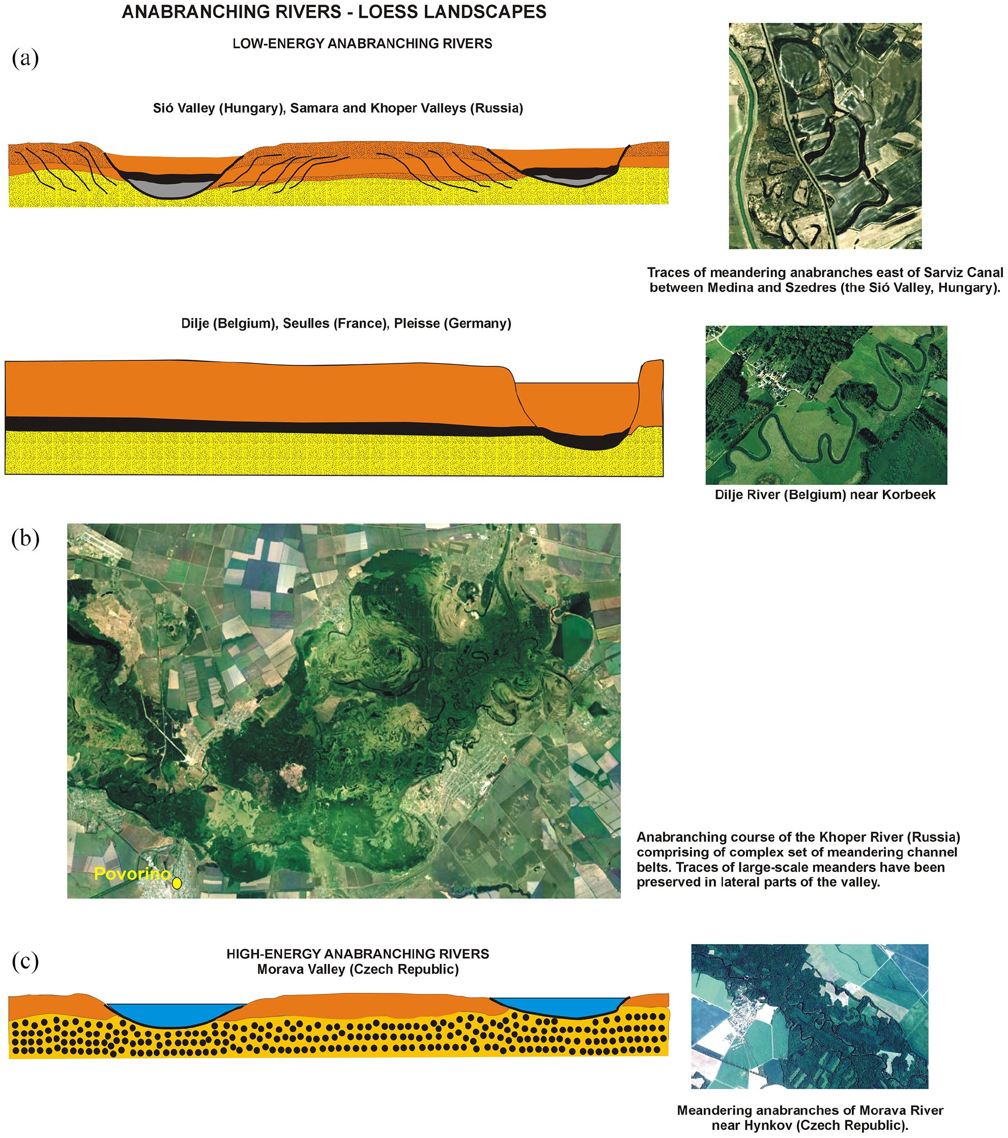
Types of sedimentary architecture of alluvial fills formed by anabranching rivers in loess areas. The geological sections were drawn based on data presented by (a) Słowik et al. (2021), Panin et al. (1999), Sidorchuk et al. (2009), (c) Bábek et al. (2018). The source of the aerial image in Figure 6b is Google Earth.
High-energy anabranching rivers (30.0–40.0 W m−2)
The evolution of the anabranching Morava River (the Czech Republic) was studied by Bábek et al. (2018). The multi-channel system was formed ~7000 cal. BP owing to increased aggradation rates and deposition of fines from tributaries. Morava is a high-energy (30.0–40.0 W m−2) anabranching river with a high magnitude of discharges (30–130 m3s−1), maximum discharge reaching 800 m3s−1, and potential specific stream power of >40 W m−2. The Morava floodplain is built of sands and gravels overlain by fines that reach the thickness up to 10 m (Bábek et al., 2018 and references therein). The channels of the anabranching section of the Morava River are shallow (0.5–2.5 m) and wide (30–40 m). The river valley bears traces of meander abandonment (see e.g. figs 7 and 8 in Bábek et al., 2018).
Grain-size features of sediments constituting meandering and anabranching river floodplains in postglacial and loess zone
Grain-size features of meandering rivers
Floodplains of meandering rivers formed in postglacial zone consist of coarse sands and gravels, formed by eroding and reworking of river bed, overlain by fine sands, silty sands and silts. Point bars marking the lateral migration of particular generations of meanders are built of upward-fining sequences: medium and fine sands overlain with fines silts and silty sands accreted by floods (e.g. the Prosna River, Poland – Rotnicki and Młynarczyk, 1989; middle Vistula River, Poland – Pożaryski and Kalicki, 1995; upper Seim and lower Svapa Rivers, Russia – Sidorchuk et al. (2001a), Borisova et al. (2006); upper Nemunas River, Belarus – Kalicki, 2006; Protva River, Russia – Sidorchuk et al., 2009; upper Dnieper, Russia – Panin et al., 2014). Sediments building meandering floodplains of postglacial zone consist in their lower parts of 40–95% of medium and coarse sands (>200 µm) (Figure 7a). Their upper parts are built of fine and very fine sands (20–200 µm; 20–70% e.g. in the Vistula Valley), and silts and clays (<20 µm; maximum 70–98% in the Dane Valley, England) (Figure 7a). The Dane exhibits the highest contrast in the floodplain grain-size – from 80% to 90% of coarse material in their bottom to fines building their middle and upper parts (Dane River – see Figure 7a). In low-energy rivers of postglacial zone (the lower Obra River, Poland – Słowik, 2016a), sediments of meandering floodplains consist of very fine and fine sands (20–200 µm) (between 25% and 90% of content). The content of medium and coarse sands reach in their bottom parts 70–85% (Figure 7a).
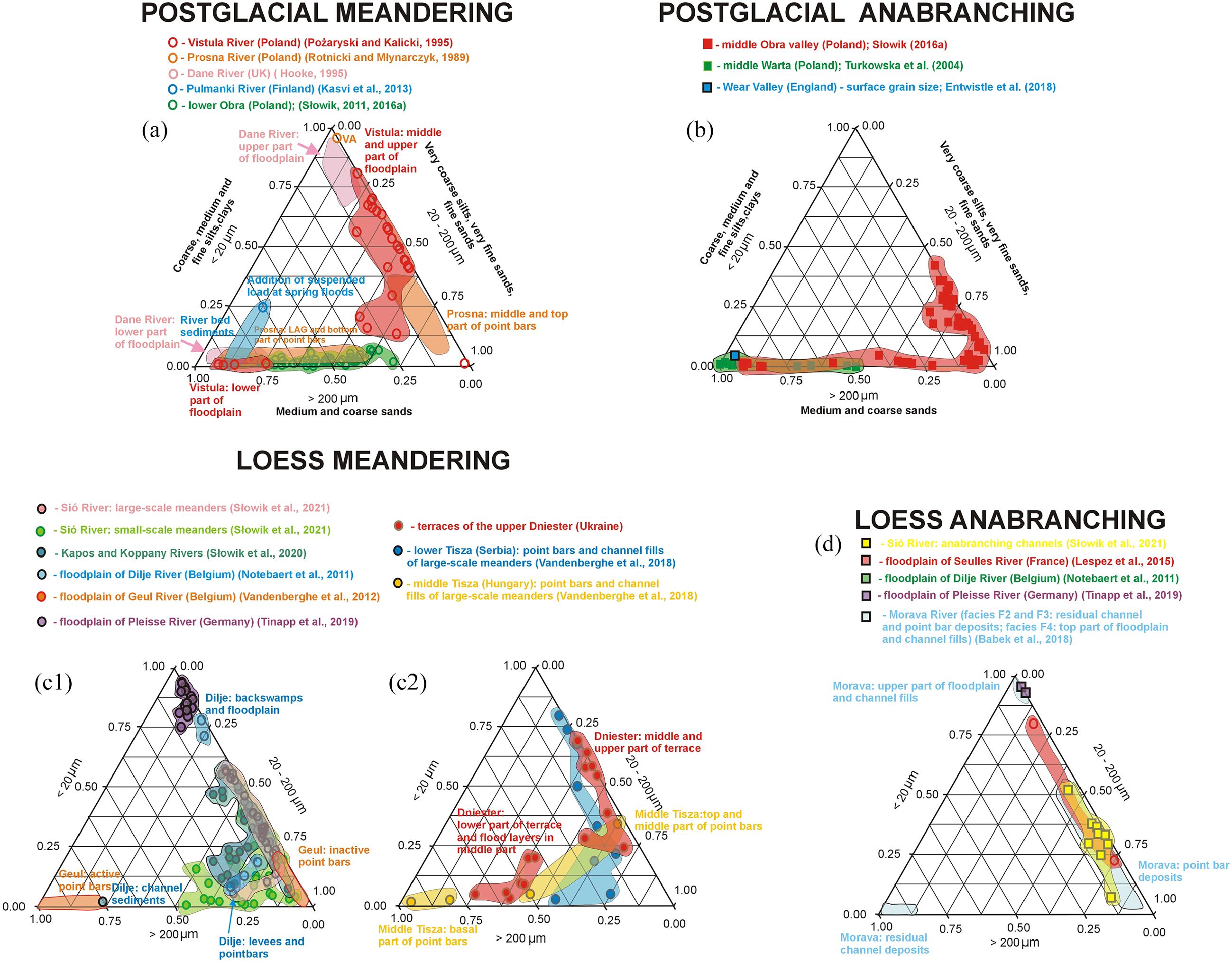
Grain-size features of meandering and anabranching rivers in postglacial (a and b) and loess landscapes (c and d) of Europe.
The upward-fining sequences are disturbed in the floodplains formed in the Late-Holocene owing to the increase of flood frequency, resulting in the formation of alluvial islands in courses of lowland meandering rivers. The upper and middle part of alluvial fills were eroded and reworked by flood events leaving layers of coarse sands and gravels in the floodplain record. This is expressed by increased content of sand fractions in the middle and upper part of floodplains in courses of the Prosna River (Poland – Rotnicki, 1991; Rotnicki and Młynarczyk, 1989, middle Vistula (Poland – Pożaryski and Kalicki, 1995), the lower Obra (Poland – Słowik, 2011), and the upper Nemunas River (Belarus – Kalicki, 2006).
Meandering floodplains of loess landscapes are built of finer materials compared to postglacial zone. Contents of fine and very fine sands (20–200 µm) varies from 40% to 90%. The content of silt and clay (<20 µm) fractions amounts between 25% and 60% in the middle and upper parts of these floodplains, with a maximum of 85–95 % in the floodplains of the Dilje (Belgium) and Pleisse Rivers (Germany) (see Figure 7c1). In low-energy rivers, contents of medium and coarse sands amount to below 50%. The exception is the Geul Valley, where coarse sands and gravels form active point bars, adjacent to the modern river bed. Fine sands and silts constitute the internal structure of inactive point bars (Figure 7c1). They are situated within elevated part of the floodplain distant from the modern river (Vandenberghe et al., 2012).
Contents of medium and coarse sands exceeding 50% appear only in the basal parts of point bars of the Tisza River (Hungary), and in lower part of terraces in the Dniester Valley (Ukraine) (Figure 7c2). Terraces of the upper Dniester Valley (Ukraine) contain layers of coarse and medium sands (content of 40–70%; Figure 7c2) deposited by flood events and formation of crevasse splays (Gębica et al., 2013). The middle and upper parts of the terrace levels are built of clays, silts, and very fine sands (Gębica et al., 2013). Point bars and channel fills of large-scale meanders of the Tisza River (Hungary) are characterized by unimodal distributions (Vandenberghe et al., 2018). In the middle course of the river, the floodplain is characterized by upward-fining sequences; the middle and top parts of point bars consist of fine sands with admixtures of silts. Sediments reaching a maximum of ~1100 μm (coarse and very coarse sands) are present in the lower and basal part of the point bars.
Grain-size features of anabranching rivers
Postglacial anabranching rivers formed floodplains with 80–90% content of medium and coarse sands (Figure 7b) (Słowik, 2016a, 2018). Anabranches with alluvial islands are built of very fine sands and fine sands (60–90% content) with admixtures of silts (37–40 % content) (Figure 7b – see details of sedimentary architecture in Słowik, 2015, 2016a). The deposits of postglacial anabranching floodplains are characterized by upward coarsening sequences (the middle Obra Valley, Poland – Słowik, 2016a; the middle Warta Valley, Poland – Turkowska et al., 2004). High-energy anabranching floodplains consists of gravels (D50 = 65 mm) covered by a thin layer of fines (the Wear River, England – Entwistle et al., 2018; see also Figure 7b).
Floodplains of anabranching rivers formed in loess areas are built of fine and very fine sands, and silty sands (the Sió Valley, Hungary – content between 60% and 80%). The content of silts and clays amounts to 25–37% (Figure 7d). Compared to postglacial zone, anabranching floodplains have no admixtures of medium and coarse sands (see Figure 7b and d). The exception is the Morava River (the Czech Republic), a high-energy anabranching river. The bottom part of its floodplain is built of gravels. They are covered with sandy deposits of point bars, and silts forming the upper parts of the floodplain (Bábek et al., 2018).
Model of evolution of anabranching and meandering rivers in postglacial and loess landscapes
The model describes processes influencing the formation of anabranching and meandering rivers in postglacial and loess areas of Europe (Figures 8 and 9).
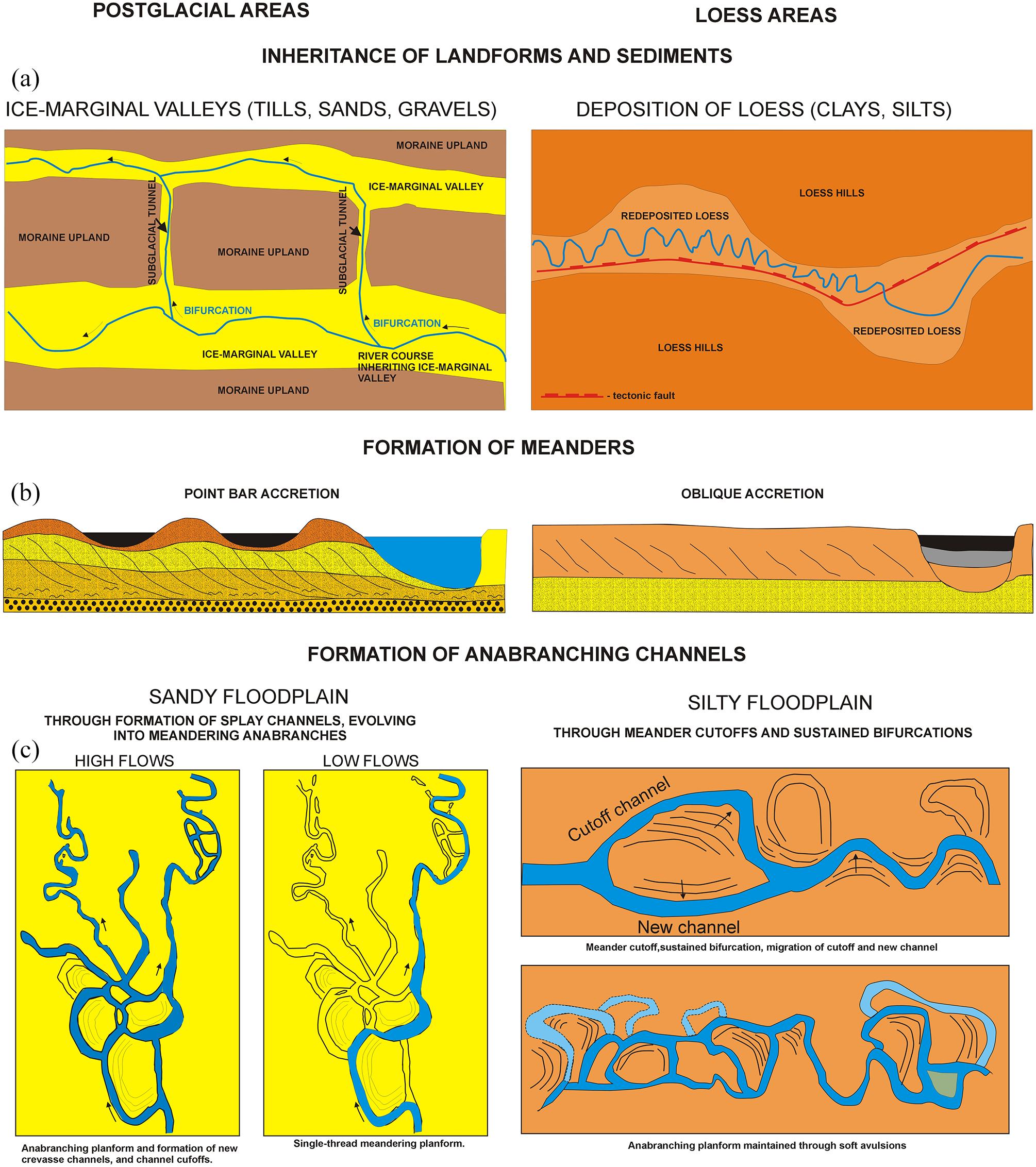
First part of conceptual model, based on examples describing the inheritance of landforms and types of sediments (a), and processes influencing the evolution of meandering and anabranching rivers (b, c) in postglacial and loess landscapes of Europe.
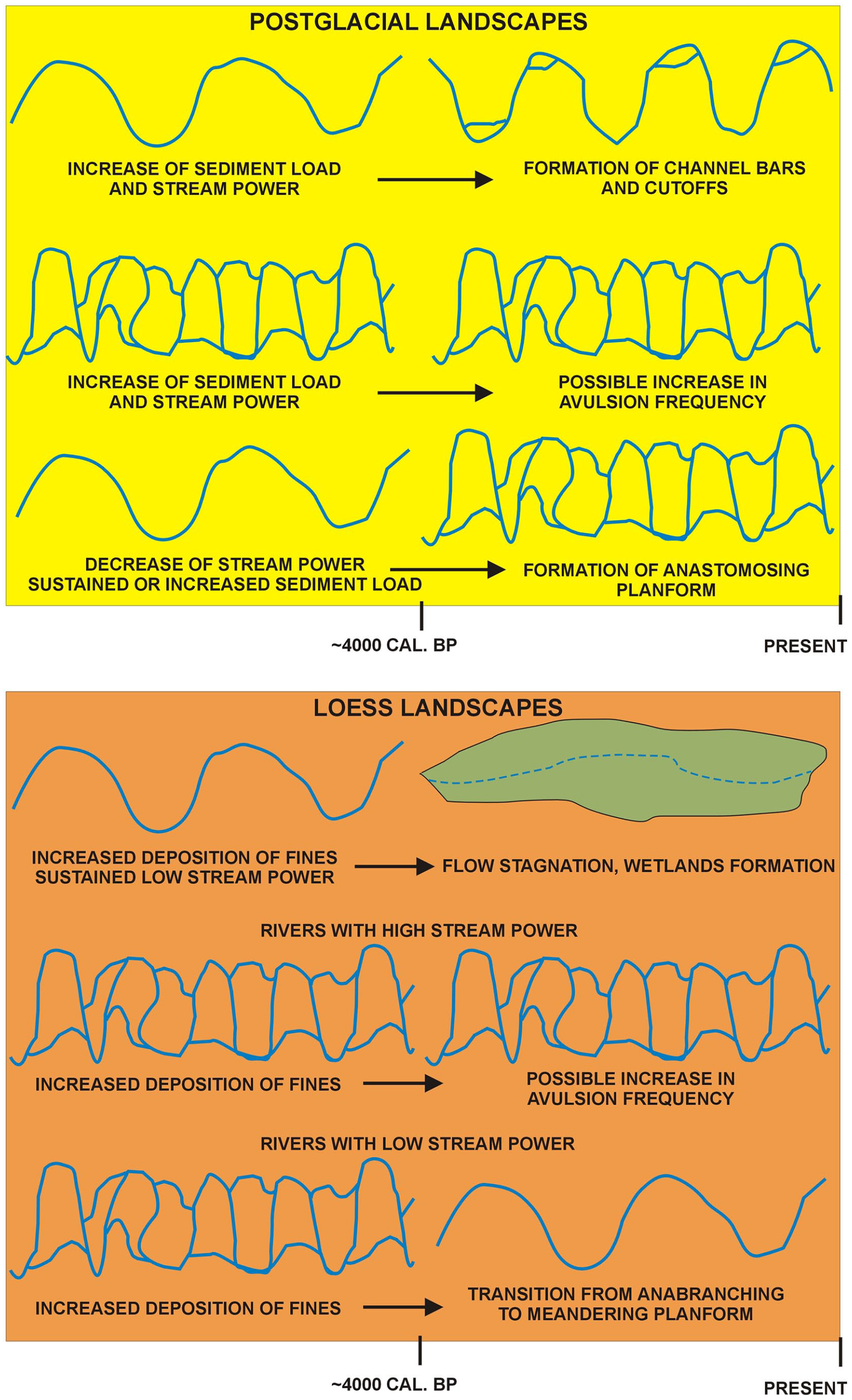
Second part of conceptual model describing sets of conditions favoring transitions from meandering to anabranching, and anabranching to meandering channel planforms in both types of landscapes. This part of the model is based on channel planform changes identified in the Late-Holocene.
Inheritance of landforms and sediments
The inheritance left by glaciations and loess formation is expressed by types of landforms and sediments. In postglacial areas these are ice-marginal valleys, former subglacial tunnels, and sands and gravels. A number of rivers in postglacial areas evolved in former ice-marginal valleys (Figure 8a). The fall of the Baltic Sea level in the Late Glacial resulted in lowering of the erosional base for rivers. This favored incision of river channels, and the formation of bifurcations through the former subglacial tunnels inherited from the period of glaciations (Figure 8a). This was the way of the formation of a bifurcation from the middle Obra to Warta River (Poland) (Krygowski, 1956; Słowik et al., 2021), and bifurcation of the Warta River from Warsaw-Berlin ice-marginal valley to the north (Antczak-Górka, 1995; Krygowski, 1956). Anabranching rivers of postglacial zone formed “delta-like” multi-channel systems at the junctions with the main rivers flowing to the Baltic and North Sea (see Figure 5). Similar “delta-like” systems were present in western Europe, where a dense network of rivers and postglacial lakes formed in the ice marginal valleys crosses with former subglacial tunnels also filled by lakes and reworked by rivers (e.g. the course of the Havel River, Germany; cf. Kaiser et al., 2012, 2018). The example can be the confluence of the Elbe and Havel Rivers with traces of large-scale meanders that could have formed a “delta-like” connection between these rivers in the past (see Supplemental Figure II, available online).
Rivers of loess areas reworked loess sediments formed in the Pleistocene at the forefront of postglacial areas (see e.g. Lehmkuhl et al., 2021 and references therein). The erosion of loess cover led to the formation of valleys surrounded by loess hills. Clays and silts (reworked loess sediments) dominate in rivers valleys of loess areas (Figure 7c and d). The erosional activity formed relatively narrow (1–3 km wide) valleys (Figure 8a) compared to ice-marginal valleys inherited by the rivers of postglacial zone (5–10 km wide). Moreover, tectonic activity took place in the Miocene, for example in Transdanubia (Hungary) (e.g. Magyari et al., 2005; Thamó-Bozsó et al., 2010) and Great Hunagarian Plains (e.g. Timár, 2003). This resulted in the formation of asymmetrically widened valley sections in river valleys of Transdanubia (cf. Lóczy et al., 2015; see also Figure 8a), and downstream changes in sinuosity (cf. Petrovszki et al., 2012; Słowik et al., 2020a; Timár, 2003). Wide river valleys (5–10 km width) provided the space for the development of large-scale meanders, for example in the Tisza Valley (Hungary) (Kasse et al., 2010; Vandenberghe et al., 2018), Dniester Valley (Ukraine) (Gębica, 2013; Kołaczek et al., 2018); Sió Valley (Słowik et al., 2021), and Samara Valley (Sidorchuk et al., 2009).
Formation of meanders
Point bar accretion governs the migration of channels in postglacial landscapes whereas oblique accretion is the main process influencing the lateral migration of river channels in loess areas (Figure 8b). The reason is the availability of sands and gravels (see Figure 7a and c1–c2). The floodplains of postglacial meandering rivers are formed through point bar accretion resulting in the formation of sequences of point bars composed of upward-fining sequences (Figure 8b; see also Figure 2a). Point bar accretion is common in postlgacial rivers of western (the Bollin, Dane Rivers – Hooke, 1995, Tywi River – Lewin and Brindle, 1977), central (e.g. Prosna – Rotnicki and Młynarczyk, 1989; Warta – Kozarski and Rotnicki, 1977; Vistula River – Starkel, 2001), and eastern Europe (e.g. Seim, Svapa Rivers – Borisova et al., 2006; Sidorchuk et al., 2001a).
Meandering rivers of loess areas migrate laterally through oblique accretion. This process is defined as “the lateral accumulation of fine-grained floodplain sediment by progradation of relatively steep convex bank in association with channel migration” (Page et al., 2003). The oblique accretion and associated meander migration take place mostly near bend apexes; both limbs of meanders are stable. This leads to the formation of elongate bends and circular pools near bend apexes in courses of many rivers evolving in loess areas, that is, the Kapos and Koppány (Hungary, Słowik et al., 2020a), Dilje (Belgium, Broothaerts et al., 2014), Geul Belgium (Vandenberghe et al., 2012), Seulles (France; Lespez et al., 2015), and Pleisse River (Germany; Tinapp et al., 2019).
Formation of anabranching rivers
Anabranching rivers of postglacial landscapes formed in sandy floodplains (Figure 7b) evolved through the formation of crevasse splays, which then evolved into sinuous and meandering anabranches (Figure 8c). A period of sustained high flows and sediment delivery was a necessary condition to create the anabranching planform (cf. Słowik, 2018). In periods of low flows the flow commenced through one major meandering anabranch (see numerical experiments of Nicholas et al. (2013) and study conducted in the middle Obra Valley by Słowik (2018). Anabranching systems with meandering anabranches were also active within ice-marginal valleys of eastern Europe. The example is the Pripyat River (Belarus), with the modern single-thread meandering channel and complex network of meandering channel belts preserved in the floodplain surface (Supplemental Figure V, available online). However, a detailed reconstruction of the formation of this complex river system requires a detailed field study yet.
Anabranching rivers of loess landscapes evolved through oblique accretion, cutoffs, and sustained bifurcations (the Sió River, Hungary – Słowik et al., 2021). After a cutoff event the flow through old and newly formed channel was maintained (Figure 8c) owing to the interactions between flow volume and channel width (Edmonds et al., 2011; Kleinhans et al., 2011; Słowik et al., 2021). The main differences between the formation of anabranching rivers in postglacial and loess areas is that the formation of crevasse channels, common in sandy floodplains of anabranching rivers in postglacial zone, is rare in loess areas. The reason can be cohesive sediments (clays and silts) constituting floodplains of loess areas (see Figure 7b and d). This is confirmed by the fact that valley sections in postglacial areas built of sediments with admixtures of fines (silts, sandy silts), indicate no traces of crevasse channels, and form sustained bifurcations around alluvial islands. Sections of anabranching rivers formed in postglacial sediments with admixtures of fines have similar features to fluvial forms of loess anabranching floodplains. These are for example alluvial islands built of series of point bars and compound bars (the middle Obra Valley, Poland – Słowik, 2015). Their internal structure reminds oblique layering within the inner bends of loess anabranching channels (the Sió River, Hungary – Słowik et al., 2021). Moreover, the bifurcations were sustained both in cases of meandering anabranches of the Sió Valley, and around the alluvial islands in section of the middle Obra Valley built of very fine sands and silty sands. The point is that the high contents of fines may have an influence on the formation of sustained bifurcations. However, this hypothesis must be verified by further field studies, extended to river valleys formed in loess areas of eastern Europe, that is the Khoper and Samara Rivers (Russia) (Figure 6). Panin et al. (1999) identified two generations of anabranching paleochannels in the Khoper River Valley. Channel abandonment within the younger generation of the channels took place ~5660–5100 cal. BP. The older generation was active in the early Holocene (Panin et al., 1999). However, the way of formation of these river planforms is not recognized yet.
Reactions of rivers to increased humidity and deposition in the Late-Holocene
Volumes of discharge, and dimensions of channels decreased in the Early and Middle Holocene (cf. Kozarski and Rotnicki, 1977; Rotnicki and Młynarczyk, 1989; Starkel, 2001; Vandenberghe et al., 2018). These hydrological changes were caused by meltwater outburst events, interrupting delivery of warm waters in the Atlantic Ocean to the north, and limiting delivery of moisture to Europe (Smith et al., 2016). During the last ~4000 years, the trend to decrease the dimensions of river channels was stopped by a coupled impact of human activity (e.g. Hildebrandt-Radke, 2013; Magyari et al., 2012), expressed by deforestation causing increased runoff and deposition in river valleys, and increased humidity, precipitation, and groundwater levels in central and east-central Europe (Gałka et al., 2018; Lamentowicz et al., 2015). Increased deposition in river valleys of western Europe appeared ~4000–3000 cal. BP (e.g. Broothaerts et al., 2014; Lespez et al., 2015; Lewin, 2010; Macklin et al., 2005). These changes were triggered by the increase of moisture delivery from the Atlantic Ocean, caused by the reduction of fresh water release to the ocean after the end of deglaciation (Smith et al., 2016). These events, together with an influence of weak solar forcing, contributed to recovery of ~1500 years long climate variability, characteristic of the Late-Holocene (cf. Bianchi and McCave, 1999; Dima and Lohmann, 2009; Smith et al., 2016).
A number of postglacial rivers of central and eastern Europe (see Figures 9, 10b and c) reacted to these changes by increase in stream power and sediment load. These changes resulted in the formation of meanders with channel bars. In smaller (2–3 km wide), low-gradient (0.0001) postglacial valleys, the increased humidity, deposition, and groundwater levels resulted in a decrease in flow energy. This is because catchments with low gradients were not able to convey the increased volume of water and sediment load. The increased runoff from valley slopes resulted in storing the excess of water and sediments in valley floors. These events favored the formation of wetlands. Such conditions resulted in transitions from meandering to anastomosing rivers (e.g. the Narew River, Poland; see also Kleinhans et al. (2012) for defining conditions to form anastomosing rivers) (Figure 9). The anastomosing Narew River has been already active since ~3800 cal. BP (Gradziński et al., 2003). Little is known about the evolution of these rivers in the Late Plenivistulian and Late Glacial. Fragments of terrace levels preserved in the Narew Valley indicate traces of activity of a braided river 15,200 BP (OSL date) (Banaszuk and Micun, 2009). The Narew River meandered in the Holocene. Traces of meandering preserved in the valley floor, and shapes of some of the anabranches suggest that some waterways of the Narew River may have been inherited from an earlier meandering system (Gradziński et al., 2000).
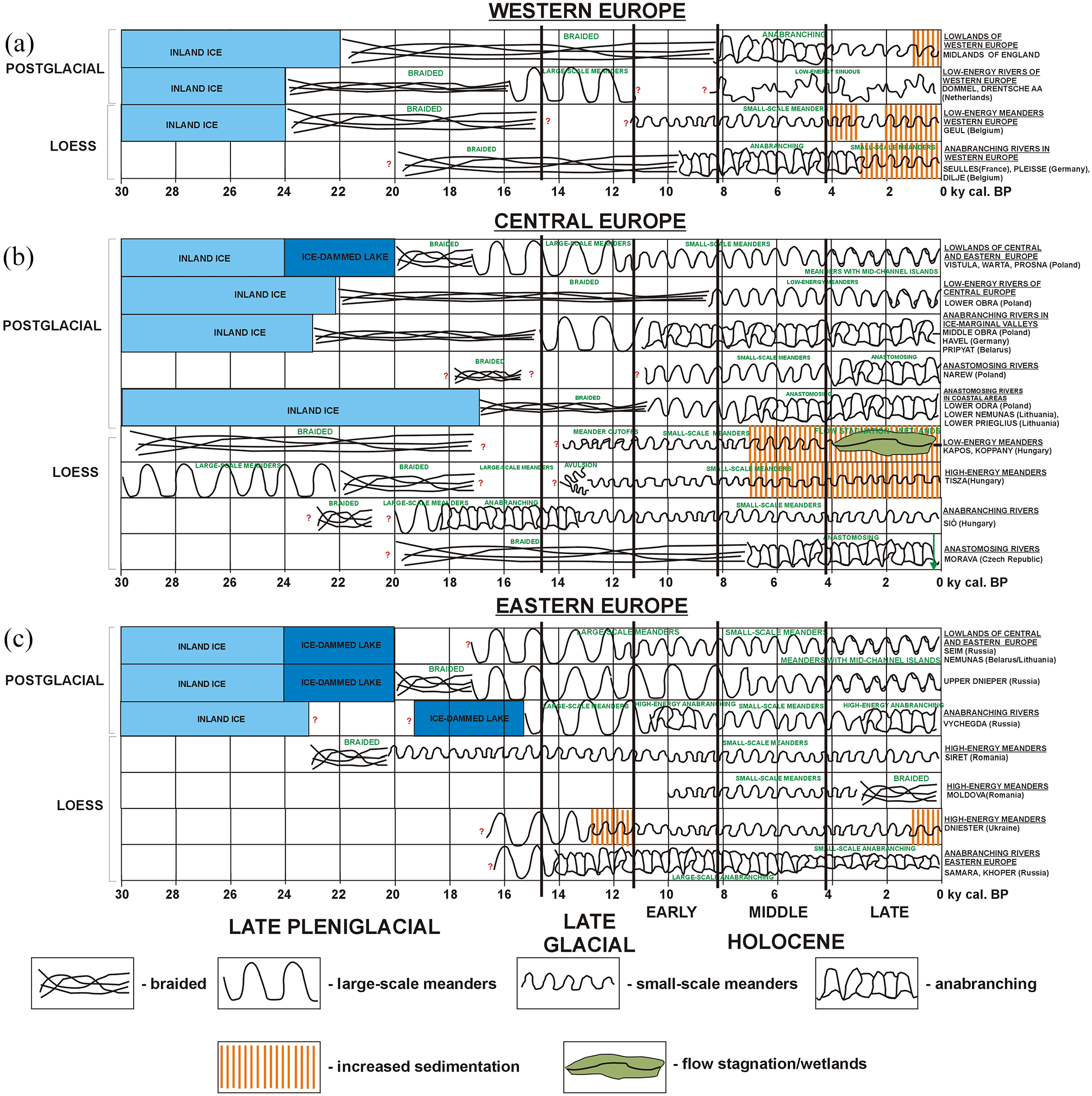
Trajectories of channel planform changes in selected meandering and anabranching rivers of postglacial and loess areas of western (a), central (b) and eastern Europe (c). Vertical orange stripes mark periods of increased aggradation.
Transitions to anabranching planforms took place also in eastern Europe, for example in the course of the Vychegda River (Russia) (Figure 10c). The formation of anastomosing river systems flowing to the Baltic Sea took place earlier than 4000 cal. BP. The rise of the Baltic Sea level ~7400 cal. BP caused the rise of base level and groundwater levels. These changes favored peatlands formation, decrease of the flow energy and the formation of anastomosing rivers (e.g. the lower Odra River; Borowka et al., 2017; Duda and Borowka, 2007). Anastomosing channel planforms are also active in the lower Nemunas River (Lithuania), and Prieglius River (Lithuania/Russia) (see Supplemental Figure VI, available online for aerial image of anastomosing course of the Prieglius River 20 km upstream of the Vistula Lagoon). The rivers of postglacial areas, that evolved in large (>10 km wide) ice-marginal valleys, maintained anabranching planforms (Figures 9 and 10b).
Rivers of loess zone in western Europe reacted to the climate changes and human impact by transitions from anabranching to meandering planforms (Figure 9). Such transitions took place in small river valleys (width 1–2 km, slope 0.0001–0.0005, stream power 0.5–1.0 W m−2) (e.g. the Seulles River, France – Lespez et al., 2015, Dilje River, Belgium – Broothaerts et al., 2014; Pleisse River, Germany – Tinapp et al., 2019; rivers of England – for example Macklin and Lewin (1989), Lewin (2010); see Figures 9 and 10a). In central Europe, small, low-energy rivers of loess areas turned into wetlands (the Kapos and Koppány Rivers, Hungary – Słowik et al., 2020a) (Figures 9 and 10b). In larger (~4.0 km wide) valleys of loess areas, meandering planforms (like e.g. the Dniester River, Ukraine) and anastomosing planforms (the Morava River, the Czech Republic) were maintained in the Late-Holocene (Figures 9 and 10b and c). The reasons could have been the large valley slope (Dniester: 0.02, Morava: 0.0009) and flow energy (Dniester: 60–70 W m−2; Morava: >40 W m−2) providing the ability to convey the increased sediment load downstream.
The relations between changes in sediment load and flow energy, and transitions of channel planforms proposed in the model (Figure 9) also refer to channel changes observed in the Late Glacial and Early Holocene. For instance, the middle Obra River (Poland) (and probably the Havel River – Germany, and Prypiat River – Belarus) changed planforms from large-scale meanders to anabranching ~11,000 cal. BP (see Figure 10b). The reason could have been the formation of bifurcations through former subglacial tunnels (cf. Słowik et al., 2020a), resulting in a decrease of discharge and stream power (caused by capturing part of the flow by a newly formed bifurcation) with sustained upstream sediment load conditions. Similar transitions took place in loess areas, in courses of the Samara and Khoper Rivers (Russia, see Figure 10c). The reasons of channel planform transitions in their course should be further studied. The Sió River changed its course from anabranching to small-scale meanders ~12,900 cal. BP, possibly owing to increased sediment delivery of fines from loess areas surrounding the valley (Słowik et al., 2021).
Perspectives to extend the existing knowledge
The present review should be extended by more examples of river floodplain architecture and channel planform evolution in both types of landscape. For instance, little is known about the evolution of rivers of the southern coast of the Baltic Sea that formed their floodplains in narrow valleys cut in moraine uplands by melt-out water of the last Inland Ice (e.g. the upper course of the Rega River, Poland; Cedro, 2007). The influence of neotectonics (formation of faults) on channel planform changes in loess areas of Europe should be further studied, too. Moreover, the present review should be extended by studies on the evolution of a transitional type of rivers, that is formed in areas where glacial and fluvioglacial sediments are covered by a thin layer of loess.
Moreover, the present study should be extended by further research work on the evolution of rivers in eastern Europe (Figure 1), subarctic rivers (also belonging to postglacial zone) as well as the evolution of large rives of Europe. Ice-dammed lakes occupied valleys used later by subarctic rivers (Johansson, 2007; Lotsari et al., 2020). The rivers formed braided planforms but the time of transition to meandering planforms in the Holocene is not known. Moreover, the influence of permafrost on the morphodynamics of subarctic rivers of Europe is understudied as well as the evolution of the Danube River. The river established its present course at the turn of the Late Pleniglacial and Late Glacial (Gábris and Nádor, 2007). At that time the Danube possibly formed a braided planform. However, there is no data how long the braided planform was active, and what planform replaced it. Tóth et al. (2017) show that the middle Danube maintained a meandering course in the Holocene. Paleomeanders have been preserved on two floodplain levels and this points to the river incision about 4700–5000 BP (OSL dating) (Tóth et al., 2017). The meandering planform was replaced by an anabranching pattern. The age of this transition is unknown. Historical maps from the 17th century show that the Danube was an anabranching river characterized by one or two main channels and several meandering anabranches (Supplemental Figure VII, available online). The multi-channel planform was active between the 16th and 19th century near Bratislava (Pišut, 2002) and Vienna (Hohensinner et al., 2013). Further studies are needed to refine the existing knowledge.
Conclusions
Most of the area of Europe is covered by areas shaped by glaciations, or covered by loess. The main goal of this study was to determine the influence of sediments and landforms of postglacial and loess areas of Europe on processes forming anabranching and meandering rivers. Findings from previous studies were synthesized. The main attention was paid to sedimentary architecture of floodplains and palaeochannels, types and grain-size of sediments constituting alluvial fills, and changes of channel planforms in the Late Pleniglacial, Late Glacial and Holocene in postglacial and loess areas.
The present study shows that landforms and types of sediments inherited from glaciations and loess formation influence the type of processes forming meandering and anabranching rivers of Europe. The inherited landforms (ice-marginal valleys and subglacial tunnels, assymetrical valleys formed by neotectonics) influenced the rivers’ evolution by formations of bifurcations in postglacial zone, and changes in channel pattern in loess zone. Point bar accretion formed meanders in postglacial zone (dominated by sands and gravels), whereas oblique accretion shaped river bends in loess areas. Anabranching rivers in postglacial landscapes evolved through the formation of crevasse channels, which then evolved into new anabranches in periods of high flows. The multi-channel systems of loess zone were formed by cutoffs and sustained bifurcations.
Rivers of the studied landscapes reacted differently to increased humidity and deposition during the last 4000 years. Meanders of postglacial zone affected by increased stream power and sediment load formed channel bars and cutoffs. The rivers that experienced a decrease in the flow energy, and sustained or increased upstream sediment load, were transformed into anastomosing rivers. Anabranching rivers in ice-marginal valleys sustained the multi-channel courses until the major hydro technical works in the 19th century. Anabranching rivers of loess zone evolving in small catchments, and characterized by low flow energy evolved into meandering courses. Rivers evolving in large valleys with high stream power maintained meandering and anabranching planforms. Low-energy meanders turned into wetlands. Further research on rivers of subarctic zone, and large rivers of Europe (i.e. the Danube River) is required to develop the understanding of processes forming rivers of postglacial and loess areas of Europe.
Supplemental Material
sj-pdf-1-hol-10.1177_09596836221131712 – Supplemental material for The evolution of meandering and anabranching rivers in postglacial and loess landscapes of Europe
Supplemental material, sj-pdf-1-hol-10.1177_09596836221131712 for The evolution of meandering and anabranching rivers in postglacial and loess landscapes of Europe by Marcin Słowik in The Holocene
Footnotes
Acknowledgements
I would like to thank Prof. P. L. Gibbard and three anonymous reviewers for constructive comments that helped improve the quality of this paper.
Funding
The author disclosed receipt of the following financial support for the research, authorship, and/or publication of this article: This research work is part of research project 2016/23/B/ST10/01027 supported by the National Science Centre, Poland.
Supplemental material
Supplemental material for this article is available online.
References
Supplementary Material
Please find the following supplemental material available below.
For Open Access articles published under a Creative Commons License, all supplemental material carries the same license as the article it is associated with.
For non-Open Access articles published, all supplemental material carries a non-exclusive license, and permission requests for re-use of supplemental material or any part of supplemental material shall be sent directly to the copyright owner as specified in the copyright notice associated with the article.