
Abstract
Estuaries are at the interface of marine and terrestrial systems and as such, are subject to environmental change arising from multiple driving mechanisms, with the interplay between the dominant controls varying spatially and temporally. Relative sea-level (RSL) change and sediment supply can play a significant role in driving environmental change. This study examines the relative influence of these drivers during the Holocene. Biostratigraphic records and RSL data are presented from two locations in the inner portion and upper reaches of the macrotidal Humber Estuary, eastern England. The results provide a new terrestrial limiting point and six sea-level index points, two of which at c. 1500 cal years BP provide the youngest sea-level index points for the inner estuary. An early-mid Holocene tidal lagoon system, that lacks modern equivalent, is recorded at one site. The results indicate a shift in the dominance of RSL rise driving the early Holocene creation of wetlands, to sediment supply dominating changes in the mid-late Holocene against the backdrop of a reduced rate of RSL rise, with a submergence of wetlands evident after c. 4000 cal years BP. The persistence of fen carr evident between c. 6800 and 5500 cal years BP suggests stability and resilience of the peatland system to continuing RSL rise. As rates of contemporary RSL rise increase, combined with climate and human impacts on the landscape, the drivers of change in these type of estuary systems will shift, with the records providing analogues of potential system responses that can help inform coastal management strategies.
Introduction
Increasing rates of relative sea-level (RSL) rise, changes in tidal range and amplitude and extreme events pose significant challenges for coastal regions and estuaries (Haigh et al., 2020; Leuven et al., 2019; Oppenheimer et al., 2019; Palmer et al., 2018). Estuary systems develop in response to a combination of marine and terrestrial processes, with the relative dominance of these influences varying spatially and temporally. RSL change and sediment supply have played important roles in driving coastal environmental change during the Holocene (Hepp et al., 2019; Metcalfe et al., 2000; Plater et al., 2000a, 2000b), and are anticipated to be significant agents of change in the future evolution of estuarine systems (Leuven et al., 2019; Robins et al., 2016).
Estuary margins and their associated wetlands are of particular importance because their resilience and capacity to adjust to change is strongly related to changes in RSL rise and sediment supply, which may occur rapidly (Hepp et al., 2019; Horton et al., 2018; Plater et al., 2000b). The response in these marginal locations in the upper estuary, at the interface of fluvial-terrestrial-marine processes, are typically not the focus of fluvial and sea-level studies. As such, the capacity of these transitionary systems to respond to changes, to both local-scale and macro-scale drivers, is not well understood. These environments, from intertidal flats to coastal marsh, contribute high biological productivity and biodiversity, as well as providing important ecosystem services, such as flood attenuation and carbon sequestration (Zu Ermgassen et al., 2021). Understanding the drivers of change over time and system responses, beyond the instrumental era, is critical to both informing and determining the success of management strategies (Hamilton et al., 2019; Plater et al., 2009).
Average rates of RSL rise >7 mm year−1 were experienced in the southern North Sea region during the early Holocene, c. 11700–8200 cal years BP (Waller and Kirby, 2021). This resulted in the landward encroachment of coasts, a dominance of tidal sedimentation and the formation of wetlands in only the most marginal areas. The slower rates of RSL rise experienced from the early-mid Holocene boundary, at 8200 years BP (Walker et al., 2012), provided optimum conditions for the formation of peat and establishment of coastal wetlands in the southern North Sea region (Waller and Kirby, 2021) and wider surrounding coastal areas.
At the mid-late Holocene boundary, at 4200 years BP (Walker et al., 2012), the mean RSL rate continued to slow and the role of more regional and local mechanisms became dominant, with the relative importance of drivers varying spatially and temporally (Hamilton et al., 2019; Shennan et al., 2000; Waller and Kirby, 2021). Such drivers include changes in tidal range, sediment supply and compaction, as well as the role of human activity in the late Holocene, with peat sedimentation typically replaced by minerogenic sedimentation during this period, and a loss of coastal wetlands (Baeteman and Declercq, 2002; Pierik et al., 2017; Waller and Kirby, 2021). Against a backdrop of low rates of RSL change, variations in local sediment supply and coastal configuration can have a significant control on the evolution of coastal areas (Hamilton et al., 2019), and such local scale responses are often not reflected in the macroscale assessments of coastal responses to projected sea-level rise (Cooper et al., 2020; Horton et al., 2018; Vousdoukas et al., 2020).
This paper examines how the inner portion of a macrotidal, tide dominated estuary responds to drivers of change between the mid and late Holocene, a period when the RSL is rising but the rate of rise declining. The sedimentary records from two locations with the inner portion and upper reaches of the Humber Estuary, a tide dominated macrotidal estuary, are investigated. We present new records of environmental changes and system responses to changing rates of Holocene RSL rise, along with RSL data for the mid and late Holocene period. These provide critical insights into the behaviour and responses of marginal estuarine locations at the fluvial-tidal interface to ongoing RSL rise. Understanding the late Holocene palaeoenvironmental change in this type of setting offers a potential analogue of responses to differential sediment dynamics and rates of RSL rise, and the relative role of regional to local scale processes in driving change. This provides an important context for the potential responses of coastal lowlands and tide dominated estuaries to future sea-level rise, and the resilience or vulnerability of the associated wetlands (Horton et al., 2018; Kirwan et al., 2016).
Holocene RSL and sedimentary history of the Humber Estuary
The Holocene RSL history of the Humber has predominantly been reconstructed from sediment records. Analysis of this litho- and biostratigraphy provides palaeoenvironmental data which when supported by a chronology (and in some cases archaeological data) enables the production of sea-level index points (SLIPs) where the dated samples can be related to a former tide level (Gaunt et al., 1974; Long et al., 1998; Metcalfe et al., 2000; Millett et al., 1987; Neumann, 1998; Van de Noort, 2004; Van de Noort and Ellis, 1995, 1998). In addition to this, Long et al. (1998) and the studies published within the Land-Ocean Evolution Perspective Study (LOEPS) (Metcalfe et al., 2000; Shennan and Andrews, 2000) provided an estuary-wide understanding of Holocene RSL change and coastal evolution in the Humber Estuary compiling regional data, enabling the creation of palaeogeographic maps (Metcalfe et al., 2000; Shennan and Andrews, 2000). Such extensive research, combining empirical and modelled data, have also identified changes in the Holocene tidal regime, including increased tidal currents and a c. 2.5 m increase in high tide level for the inner reaches of the estuary since c. 6000 14C years BP (c. 6800 cal years BP) (Shennan et al., 2003).
The Humber Estuary is located within a glacio-isostatic region of Holocene RSL rise (Shennan et al., 2018), with the Humber Valley system becoming progressively flooded in response to RSL rise during the Holocene. RSL rose at a rate of c. 3.9 mm year−1 during the early-mid Holocene, c. 7500–4000 cal years BP, reducing to c. 1 mm year−1 over the last 4000 cal years BP (Horton and Shennan, 2009; Long et al., 1998). The rise in RSL in the estuary, and the wider region, is predicted to continue throughout the 21st century in response to anthropogenic climate change induced warming (Palmer et al., 2018). Global projections suggest a sea-level rise in excess of 0.5 m by 2100, though uncertainty over high-latitude marine ice cliff instability, coupled with information from structured expert judgements suggest potential larger (c. 1 m) rises might be expected (Fox-Kemper et al., 2021; Horton et al., 2020; Kopp et al., 2017; Oppenheimer et al., 2019; Palmer et al., 2020). Instrumental observations indicate an acceleration in global mean sea-level rise over the 20th and 21st centuries, with a rate of 3.69 mm year−1 observed over the most recent period 2006–2018 (Fox-Kemper et al., 2021), approaching the rate experienced in the Humber during the early Holocene.
Holocene RSL rise triggered the expansion of both floodplain and intertidal wetlands within the estuary, with the palaeogeography and extent of the tidal influence broadly reflecting the pattern of RSL change (Dinnin and Lille, 1995; Metcalfe et al., 2000). Intertidal and subtidal environments were restricted to the outer portion of the estuary in the early Holocene (Long et al., 1998; Metcalfe et al., 2000), with marine influence becoming established in the inner estuary during the mid-Holocene (Kirby, 1999, 2001; Metcalfe et al., 2000). Intertidal environments reached their maximum extent c. 3000 cal years BP (Kirby, 1999, 2001; Lamb et al., 2007; Long et al., 1998; Metcalfe et al., 2000). These changes can be attributed to the interplay between RSL, tidal dynamics and sediment supply. In response, distinct sediment suites have been identified with the estuary, reflecting changes in accommodation space and sediment sources and supply during the Holocene (Rees et al., 2000).
The interplay of RSL, tidal and sedimentary dynamics can result in the transformation of estuarine environments, as evidenced in other locations bordering the North Sea, such as the Belgian coastal lowlands (Baeteman, 2008; Baeteman and Declercq, 2002), the Elbe (Hepp et al., 2019) and the Tees (Plater et al., 2000a, 2000b), with changes manifest over sub-centennial timescales (Hepp et al., 2019). Anthropogenic activities become increasingly significant in the late Holocene, with deforestation altering the sediment mobilisation within the Humber catchment (Beckett, 1981; Buckland and Sadler, 1985; Smith, 1958), and the Tees (Plater et al., 2000a, 2000b), increasing the delivery of sediment supplied to coastal lowlands. The Humber and other southern North Sea regions have also experienced rapid changes during the last several centuries due to the land reclamation and management practices (Heathcote, 1951; Metcalfe et al., 2000; Sheppard, 1966; Waller and Kirby, 2021), resulting in a significant reduction in the area of intertidal and wetland environments and corresponding changes in tidal regime and resilience (Jickells et al., 2000; Metcalfe et al., 2000).
With predicted continued rise in future RSL (Fox-Kemper et al., 2021; Oppenheimer et al., 2019; Palmer et al., 2018) and shifts in tidal and sediment dynamics (Haigh et al., 2020; Leuven et al., 2019), understanding the response of these estuary systems to change is important and the impacts potentially multi-faceted (Robins et al., 2016). In the context of anthropogenically modified landscapes, the uncertainties of sediment dynamics and RSL rise for coastal resilience are important considerations for coastal management (Hamilton et al., 2019).
The Humber Estuary drains approximately 20% of river systems in England. It extends c. 60 km inland, from Spurn Point to the confluence of the River Ouse and River Trent, and the tidal influence extends c. 140 km inland. It is a macrotidal and highly turbid estuary (Jickells et al., 2000). The estuary provides a crucial infrastructure link, with the ports of Grimsby and Immingham handling the second highest annual tonnage in the UK in 2020 (Department for Transport, 2021), and the contributory rivers Ouse and Humber providing inland waterways. As the rate of modern sea-level rise increases towards that experienced in the Humber during the early to mid-Holocene, understanding past dynamics of the driving processes of change is crucial for understanding the responses of coastal areas to future conditions.
Study sites
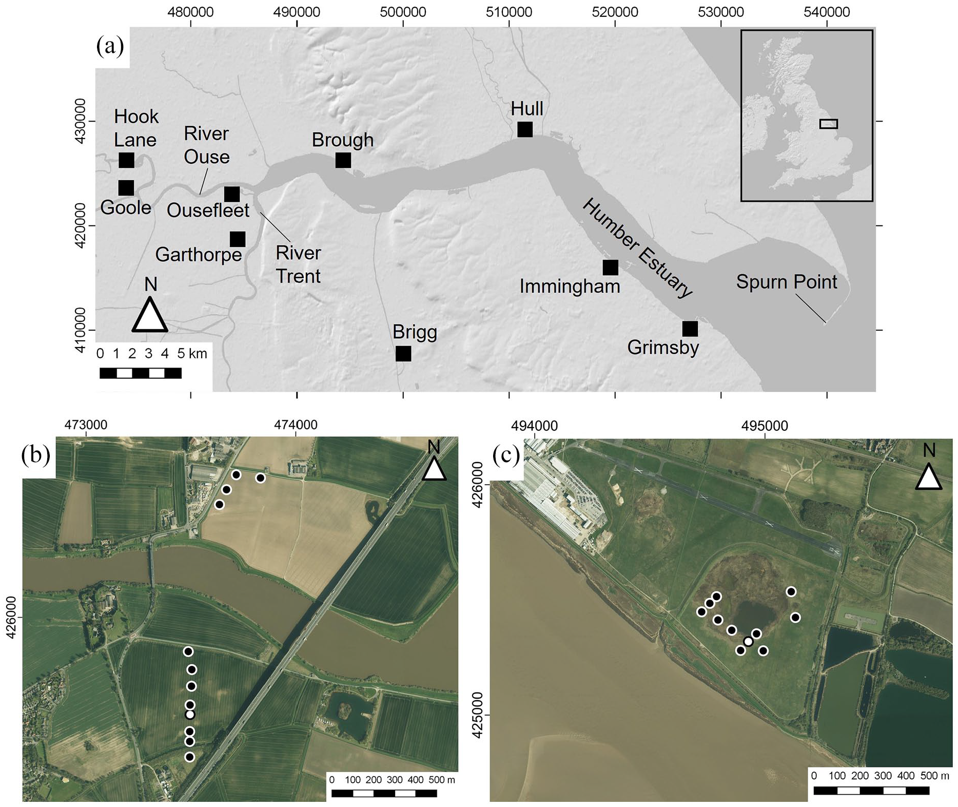
To examine the system responses to changing RSL rates and sediment dynamics, two sites in the upper reaches of the inner estuary were selected that cover the fluvial-tidal interface. The Humberhead Levels and Vale of York are low-lying, flat regions that flank the inner Humber Estuary, and through which some of the main tributary rivers to the estuary flow and meet. Hook Lane is located north of Goole, immediately downstream of the confluence of the River Aire with the River Ouse (53°43′16.6″N; 0°53′07.6″W; Figure 1). It is situated on the floodplains of the River Ouse, at the northern limits of the Humberhead levels region and on the southern edge of the Vale of York (Van de Noort and Davies, 1993). Hook Lane lies at the lower tract of the fluvial systems of the River Ouse and its tributary rivers, approximately 10 km east of the Humber Estuary and within the tidal influence. Brough is located on the northern banks of the inner estuary (53°42′56.8″N; 0°33′53.08″W; Figure 1), within the Vale of York region of the Humber Basin (Van de Noort and Davies, 1993), approximately 20 km east of Hook Lane. These sites capture the interface of terrestrial-marine estuary dynamics, with Brough located in the upper reaches of the estuary, and Hook Lane in the tributary fluvial valley and lowland system.
Methods
Stratigraphic surveys were undertaken using hand-operated Eijkelkamp gouge corers with sediment description following the Troels-Smith (1955) classification scheme. Core locations were surveyed to Ordnance Datum Newlyn (m OD) using an optical ‘dumpy’ level and staff with a closing error <0.03 m at Hook Lane, and with a Trimble R6 differential GPS base station and rover unit and errors c. 0.01 m at Brough. Representative cores were collected for laboratory analysis from each site; BC02 at Brough, and HK4 from Hook Lane.
Due to the variable presence of microfossils in Holocene sequences around the Humber (Long et al., 1998; Metcalfe et al., 2000), multiple microfossil proxies were used. Diatoms assemblages were analysed to establish the former hydrological environment; the relationship to salinity enables the identification of marine, brackish and freshwater conditions. Subsamples c. 0.5–1 cm3 were treated with 30% H2O2 digest to remove organic material (Palmer and Abbott, 1986) and mounted on microscope slides with Naphrax. About 200–300 valves per sample were systematically counted and identified at ×400–×1000 magnification following the taxonomy of Hartley (1996), Hendey (1964), Van der Werff and Huls (1958), Germain (1981), Carter and Bailey-Watts (1981) and Krammer and Lange-Bertalot (2010).
At Brough, foraminifera were analysed to identify marine influence. Foraminiferal sample preparation followed standard techniques (Scott and Medioli, 1980), with an optimum of 200 specimens per sample counted and identified according to the taxonomy of Murray (1971, 2000). At Hook Lane, pollen was analysed to reconstruct the local and regional vegetation changes in the fluvial and perimarine zone and to provide a depositional context for the organogenic sediments. Subsamples of c. 1 cm3 were prepared for pollen analysis following standard preparation procedures (Moore et al., 1991). Prepared samples were mounted in silicone oil and counted under ×400–×1000 magnification. A minimum of 300 land pollen grains (not including Alnus glutinosa) were identified to the lowest taxonomic level wherever possible (see Bennett (1994)) following the taxonomic keys in Moore et al. (1991) and reference slides.
Ten radiocarbon ages were established for HK4 using a combination of conventional radiocarbon dating and accelerator mass spectrometry (AMS) dating. This approach allowed the coupling of conventionally dated bulk samples to AMS dated plant macrofossils from adjacent stratigraphic levels. Five AMS radiocarbon ages were established for BC02 (NERC allocation number 1932.1015) from bulk material and unidentified plant macrofossils (Table 1). All dating was undertaken by the Radiocarbon Facility in East Kilbride. All ages have been calibrated using Oxcal v4.4 and IntCal20 (Bronk Ramsey, 2009; Reimer et al., 2020).
Radiocarbon ages collected in this study.
Ages calibrated as outlined in the methods with 2σ age uncertainty.
Denote coupled conventional bulk and AMS plant macrofossil ages.
Terrestrial limiting and sea-level index points were determined following established protocol (Hijma et al., 2015). The vertical errors include surveying error (±0.01 m at Brough; ±0.03 m at Hook Lane), compaction during coring (±0.01 m), coring angle (±1% sediment overburden) and sample thickness (±half sample thickness) (Shennan, 1986; Törnqvist et al., 2008). Tidal corrections are applied following Shennan et al. (2003).
Results
Hook Lane
The stratigraphy is characterised by pre-Holocene basal clay-sand deposits overlain by a wood peat in the most northerly cores and south of the River Ouse (Figure 2). Overlying the peat is a finely laminated humic clay with varying organic detritus, overlain by a wood peat with variable clay horizons. In the most southerly and northerly cores, this wood peat layer directly overlies the basal clay-sand deposit. The wood peat gradually changes into an organic clay with woody detritus, and is overlain by clay. In the two cores immediately north of the Ouse, the lowest unit comprises extensively laminated sands, silts and clays, overlain by the organic clay unit, and does not contain the peat units observed in the other cores of the transect (Figure 2).
Simplified stratigraphy at Hook Lane; coring locations correspond to locations in Figure 1B.
HK4 has a ground surface elevation of +1.91m OD, and the Holocene record extends to c. 10m in depth (Figure 2). The base comprises a 0.07m thick sand unit overlain by 0.47m of thick stiff silty-clay. This is overlain by 0.2m of peat, replaced by 2.54m of clay laminated with organic detritus comprising a varying presence of wood and plant fragments. Overlying this is a 1.92m thick clayey wood peat, replaced by 2.2m organic clay with wood and plant detritus. This is overlain by 0.52m of organic silty clay, followed by 0.6m of silty clay with some peat detritus, capped by topsoil.
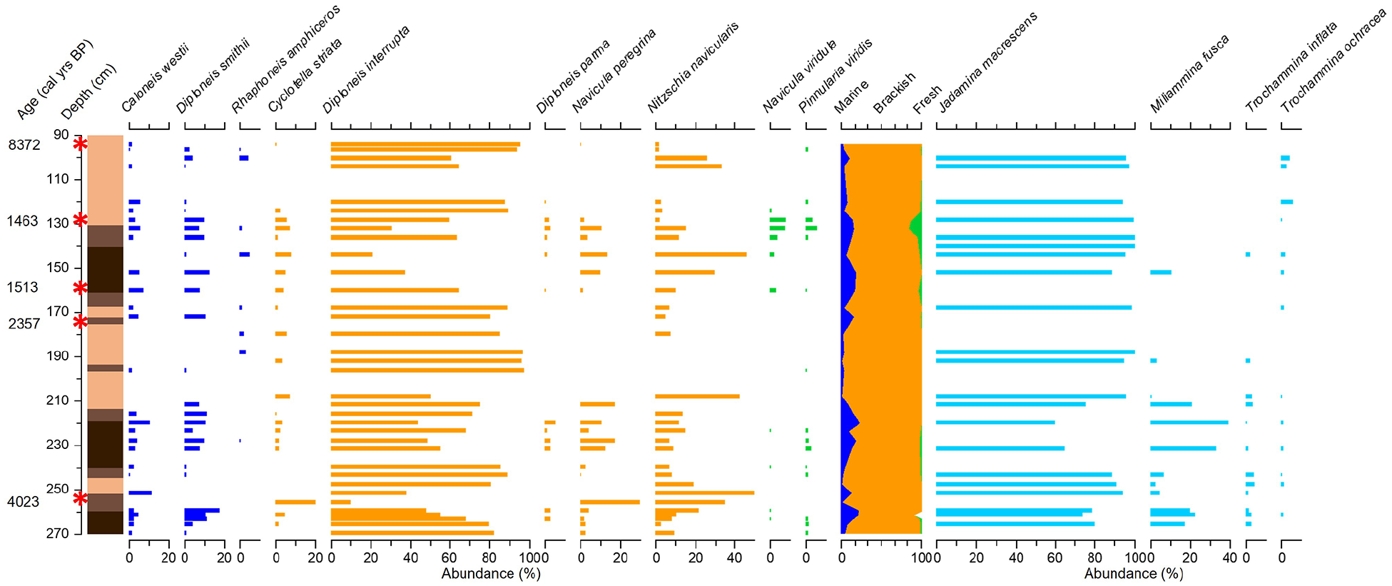
Diatoms are preserved and identified in the organic clay units (Figure 3). Through the lower organic clay unit there is a decline in the presence of freshwater and indifferent diatom species such as Gyrosigma attenuatum, replaced by the increased presence of brackish species such as Cyclotella striata. The upper organic clay unit is dominated by brackish species such as Diploneis interrupta, Cyclotella striata, Navicula peregrina and Nitzshcia navicularis, with varying abundances of marine and freshwater taxa. Unidentified foraminifera test linings are also observed in the upper organic clay unit.
The pollen record is dominated by arboreal and shrub taxa in the lowest peat unit, particularly Corylus, Alnus and Quercus, with arboreal pollen abundance increasing across the transition into the lower organic clay unit and Corylus (shrub) pollen abundance decreasing (Figure 3). The frequency of arboreal, shrub and herb species remains relatively consistent through the overlying sediments although there is an increase in Fraxinus pollen abundance within the peat unit around 6.40 m depth commensurate with an Ulmus decline. Herb taxa, notably Poaceae, and spore abundance increases and arboreal species decline through the upper organic clay unit. There is a distinct increase in herb species, such as Filipendula, at 3.05 m depth (Figure 3), with a return to mixed presence of arboreal, shrubs and herbs in the overlying organic clays, with a higher proportion of herb pollen than the lower organic clay unit.
Ten radiocarbon ages were established (Table 1). Three are AMS radiocarbon ages coupled to three bulk conventional radiocarbon ages; due to the complexities and unknown provenance of the wood deposits used for the AMS dating, the conventional bulk dates are used to establish the chronology (see full discussion on this in Kirby (1999)). The ages span from 7863 cal years BP at the base of the basal peat, to 4401 cal years BP in the upper organic clay unit.
Brough
The stratigraphy is characterised by a thin basal silt-sand unit overlain by a highly organic peat unit containing degraded wood fragments, which becomes increasingly minerogenic up-core. This is overlain by silt-clay units (Figure 4). The silt-clay units have varying organic content, with some containing intercalated minerogenic peat units (Figure 4).
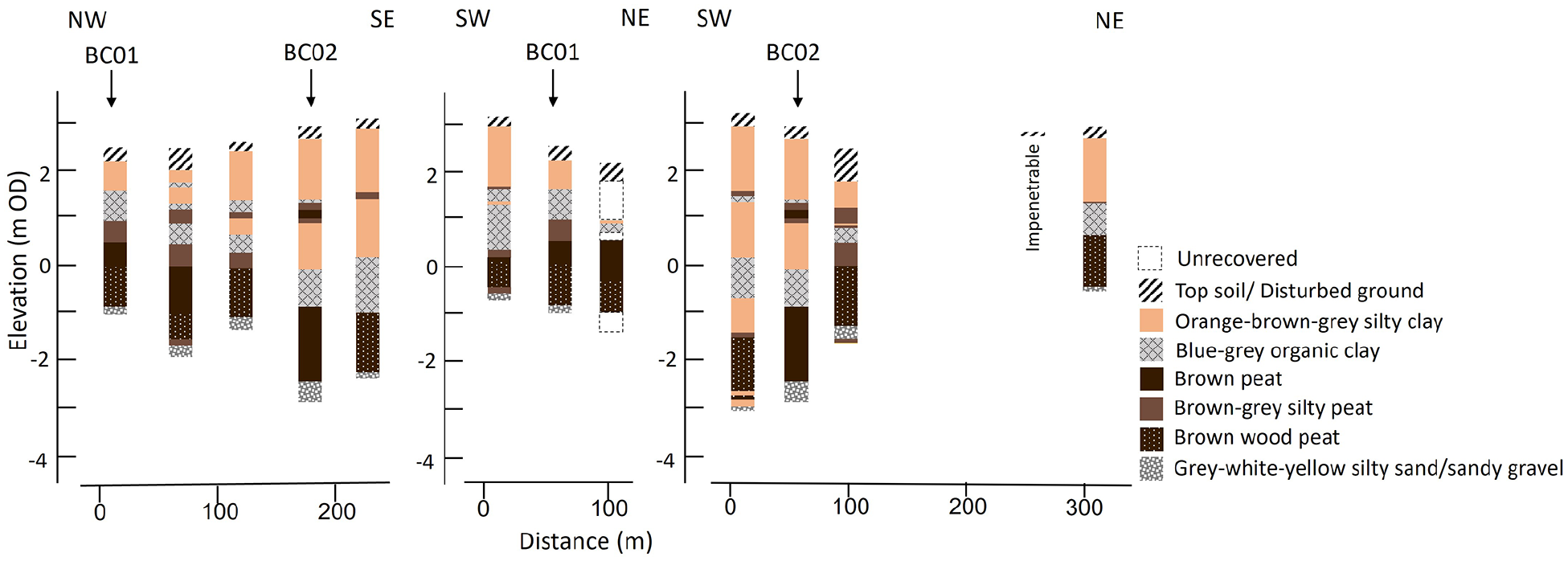
Simplified stratigraphy at Brough; coring locations correspond to locations in Figure 1c.
BC02 has a ground surface elevation of 2.40 m OD, and the Holocene deposits rest on a solid diamict base at depth 4.55 m (−2.16 m OD). A coarse silty-sand basal unit extends 0.21 m, and is overlain by a 0.13 m thick black silty unit (Figure 4). This gradually changes into a 1.35 m thick organic wood peat, overlain by 0.21 m of highly fibrous peat and 0.16 m of an organic clay-silt unit. This is overlain by 0.3 m thick peat unit, followed by 0.13 m of organic clay-silt that becomes increasingly inorganic, overlain with 0.9 m of a brown-grey-blue clay-silt. The uppermost 0.37 m comprises a compact topsoil.
Diatoms occur within the silty-peat units and organic clay-silts, but are absent from the lower highly organic peat units and uppermost clay silt units. Diatoms are present from 2.70 to 0.94 m depth, with a 0.16 m hiatus in presence between 1.2 and 1.04 m depth. A total of 34 species are identified, and the profile is predominantly characterised by brackish species, particularly Diploneis interrupta (Figure 5). Increases in abundance of Nitzschia navicularis, Navicula peregrina and Cyclotella striata and Diploneis smithii generally corresponds with stratigraphic changes into less organic sedimentary units. Foraminifera presence generally mirrors that of the diatoms, and is dominated by the brackish agglutinated species Jadammina macrescens, with some variable presence of Miliammina fusca from 2.66 to 1.92 m depth. No calcareous species were present.
Five AMS radiocarbon ages were obtained (Table 1). The ages extend over the latter half of the Holocene and are in stratigraphic order, with the exception of the shallowest dated horizon that produced an age of 8372 (8422–8215) cal years BP. This age is interpreted as an anomaly, and older than the depositional context, potentially due to erosion and reworking. In other areas of the Humber catchment, it has been suggested that anthropogenically induced sediment mobilisation in the late Holocene resulted in the remobilisation and redeposition of pre-Quaternary and coal particles, contaminating sediment with older carbon (Bayliss and Dinnin, 1995).
Discussion
The litho- and biostratigraphy reveal distinct changes in palaeoenvironment at both sites, and represent differential system responses to varying processes, predominantly rates of RSL rise and sediment supply, during the Holocene; these are summarised in Figure 6.
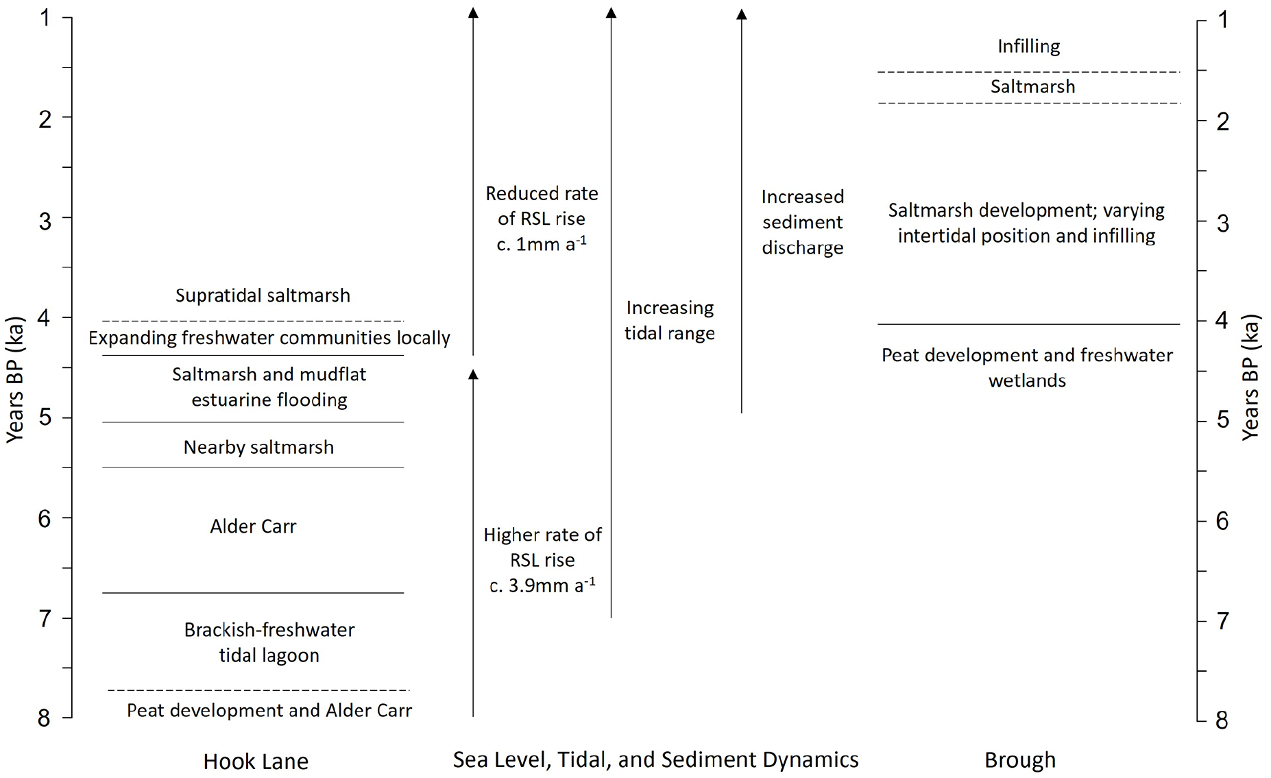
Summary of the environmental changes at Hook Lane and Brough, and changes in RSL, tidal and sediment dynamics.
Mid-Holocene environmental change
At Hook Lane, the most inland site, the basal minerogenic sediments reflect the local valley bottom glaciogenic sediments associated with the tills and glaciolacustrine sediments from Late Devensian ice (Bateman et al., 2015). Following deglaciation and the climate amelioration into the Holocene, regional groundwater level rise associated with rising RSL began the transformation of the estuarine margin system. Paludification is recorded at lower valley sites adjacent to the estuary, dated from c. 9200 cal years BP at Ousefleet and Bole Ings locations (Brayshay and Dinnin, 1999; Metcalfe et al., 2000), Garthorpe at c. 8000 cal years BP and Brigg at c. 7000 cal years BP (Neumann, 1998; Ridgway et al., 2000). A Hook Lane, peat development occurred c. 7800 cal years BP within an alder dominated freshwater fen carr, as defined in Rodwell (1995). The biostratigraphy indicates the development of a largely wooded floodplain wetland system, with shifts in wetland and aquatic herbaceous communities, and the ultimate spread of alder dominated fen carr environment.
The fen carr environment is relatively short lived, and replaced by an influx of inorganic sediments and a corresponding decline in Alnus pollen frequencies, indicating flooding of the area. RSL in the Humber was rising at a relatively rapid rate of c. 3.9 mm year−1 (Horton and Shennan, 2009; Long et al., 1998), creating accommodation space as water levels rise. At this time, the river valley was underfit for the amount of accommodation space being created by RSL rise. As the rate of sedimentation cannot keep pace, the system response is flooding, submergence and eventually the creation of expansive tidal lagoonal conditions. The diatom biostratigraphy indicates a submerged environment that is initially freshwater and perimarine in nature, reflecting the role of rising water tables and impeded fluvial drainage. However, the presence of organic laminations interspersed within the clay deposits, and the increasing frequency of brackish planktonic diatom taxa Cyclotella striata indicates a transition to a brackish tidal lagoon, and expanding marine influence in the upper reaches of the estuary. Increasing marine input and expanded estuarine influence is reflected by the increased presence of the planktonic species Paralia sulcata, indicating a transformation of the inner estuary environment into one dominated by RSL and marine processes.
The pollen data indicate the continued presence of alder-dominated fen carr wetland peripheral to the lagoonal environment. Although Salix pollen is under-represented in the spectra (Waller et al., 1999), this species must have formed a significant proportion of the local wetland vegetation as the lagoonal deposits are frequently laminated with Salix leaf macrofossils.
Perimarine tidal lagoonal systems comparable to those evident from the inner Humber are uncommon and indeed, have no modern equivalent in NW Europe today. However, a broadly similar palaeoenvironment, both in its timing and nature has been reported from the upper reaches of the Tees estuary at Billingham Beck (Plater et al., 2000a, 2000b). Van der Woude (1984) describes a freshwater ‘fluviolagoon’ palaeoenvironment in the Rhine-Meuse delta in the early Holocene, but these lack the brackish tidal influence evident within the inner Humber estuary deposits. The relatively short-lived and ephemeral nature of these tidal lagoons is related to the specific conditions required for their formation, and are not replicated at other times during the Holocene in NW Europe.
The rate of RSL rise slowed towards the mid-Holocene, enabling sedimentation to catch-up and infill the accommodation space. Lagoonal conditions shallowed, enabling a semi-terrestrial wetland and alder carr environment to be locally re-established at c. 6800 cal years BP. This is similar to lagoonal changes identified in the southern North Sea Dutch lower valley systems at a comparable time (Vos and De Wolf, 1994, 1997). Although the pattern of RSL continued to rise during this time, suggesting an expansion of marine conditions, there were other mechanisms influencing coastal development. Shennan et al. (2000, 2003) have demonstrated that as tidal waters expanded into coastal lowlands around 7000 cal years BP, this increased water depth and reduced frictional effects, resulting in an increase in the tidal range up estuary. This tidal asymmetry would likely result in a sediment surplus flushing into the surrounding lower valleys, explaining the infilling of the tidal lagoon and enabling the establishment of wetlands rather than continued submergence. Shifts in tidal dynamics due to RSL rise have also been shown to trigger rapid sedimentation in coastal lowland valleys elsewhere in the North Sea basin (Hepp et al., 2019). Whilst RSL rise acted as a dominant external driver of change in the early Holocene, this period marks a shift to the increasing role of other regional-local scale factors driving system changes.
A phase of relative stability is reflected from c. 6800 to 5500 cal years BP as conditions favoured the development and persistence of alder-dominated fen carr. Such conditions have been reported from other UK coastal lowland areas, where thick peats developed in response to lower rates of RSL rise conducive to the regeneration and vertical accumulation of fen peat sequences (Waller and Early, 2015; Waller et al., 1999; Waller and Grant, 2012; Waller and Hamilton, 2000; Waller and Kirby, 2021; Waller and Marlow, 1994). In the Humber, such fen carr vegetation was widespread within the river valleys surrounding the estuary during the mid-Holocene period (Metcalfe et al., 2000). Within this period, the Ulmus decline is recorded in the pollen record. The coincident increase in presence and abundance of Fraxinus pollen suggests ash was able to take advantage of available space and light in the dryland woodland.
At Hook Lane, around c. 5200 cal years BP, the sediments increasingly become less organic and more clay rich, and the presence of brackish planktonic diatoms are indicative of a transition to a saltmarsh environment and expanding marine influence. This is consistent in timing with the expansion of intertidal environments into the lower valley systems during the mid-Holocene (Metcalfe et al., 2000). The diatoms indicate initially a high saltmarsh environment at Hook Lane, with Diploneis interrupta the most common species. The influence of continued estuarine flooding is suggested by the co-dominance of the brackish planktonic diatom species Cyclotella striata. Marsh conditions evidently become increasingly brackish/marine dominated from c. 4700 cal years BP, as suggested by the increase in Paralia sulcata in the diatom record. From c. 4400 cal year BP, the pollen data infer the local expansion and encroachment of freshwater wetlands, with marsh and fen environments characterised by wetland herb taxa including Poaceae and Filipendula. These changes reflect an interplay of the hydrological and sediment dynamics in driving the system responses against the backdrop of continued RSL rise, with the rate of RSL rise reducing to c. 1 mm year−1 over the last 4000 years (Horton and Shennan, 2009; Long et al., 1998).
Mid to late Holocene environmental change
Brough reflects a period of coastal adjustment in the upper reaches of the estuary during the mid-late Holocene. The basal peat in the lower portion of the Brough sequence is consistent with the presence of freshwater aquatic and eutrophic wetlands during the early to mid-Holocene (Metcalfe et al., 2000), with paludification initiated by RSL rise raising the local water table. The transition into silty-peat units, at c. 4000 cal years BP, and subsequent shifts into minerogenic silt-clay units, is consistent with the sedimentary succession seen in other Humber sequences (Long et al., 1998; Metcalfe et al., 2000), and elsewhere around the North Sea region (Waller and Kirby, 2021).
The mid to late Holocene period coincides with significant changes in the sediment supply and continuing increase in tidal range in the inner estuary. From c. 5000 years BP, sediment catchment loads into the estuary increased, associated with enhanced sediment erosion and supply due to land cover changes and deforestation (Beckett, 1981; Buckland and Sadler, 1985; Shennan et al., 2003; Smith, 1958). These interpretations from the sedimentary and archaeological records are supported by modelling, which show sediment discharge peaks in the estuary after 2000 cal years BP of significantly greater magnitude than the sediment delivery pre-5000 cal years BP (Shennan et al., 2003). Whilst model predictions indicate increased tidal range of c. 2.5 m since c. 6000 14C (c. 6800 cal years BP), the significant increase in range indicated from 4000 to 3000 14C (c. 4500–3200 cal years BP) to present has not been adequately modelled and are likely maximum estimates of the changes in tide level (Shennan et al., 2003).
The litho- and biostratigraphy at Brough represent the shift into brackish, intertidal environments at c. 4000 cal years BP, and are consistent with the expansion of marine influence and wetland submergence in the inner estuary, as the intertidal area reached a maximum extent in the estuary at c. 3000 cal years BP (Metcalfe et al., 2000). The subsequent sequence of inorganic sediments and intercalated organic units, with shifts between increasingly marine and brackish diatom flora respectively, indicate changes in the extent of marine influence and sedimentary environments between c. 4000 and 1500 cal years BP. The presence of agglutinated foraminifera suggest an intertidal, saltmarsh environment and the diatoms indicate a predominantly high saltmarsh setting, with a dominance of Diploneis interrupta. Nitzschia navicularis can habit a range of settings, including intercreek areas, creeks, high saltmarsh and mudflats (Metcalfe et al., 2000), and its varying co-dominance along with shifts in the minor (<20%) presence of marine species, suggests varying tidal incursions onto the site.
Whilst a simplified approach is to attribute the shifts between organic and minerogenic sediments to fluctuations in RSL, this can result in misleading interpretations (cf. Baeteman et al., 2011; Behre, 2007), and overlooks the critical role and interplay that other processes, such as sediment supply and compaction, can have in driving sedimentation and coastal change (Hamilton et al., 2019; Jennings et al., 1995). Indeed, the Humber Estuary experienced continuing RSL rise through the Holocene (Shennan et al., 2018), and therefore the changes seen in the stratigraphic record cannot be attributed to vertical fluctuations in RSL (or at least cannot be resolved within the margins of error, or explained with any known climate forcing mechanisms). Increased minerogenic sediment loads, combined with lower rates of RSL rise, contributed to the submergence of wetlands in the inner estuary as they were no longer able to regenerate and fill the accommodation space. In response, the wetlands dewatered, beginning the significant process of autocompaction. Rather than RSL rise, this reduction in stratigraphic volume created significant accommodation space and rapid infilling with minerogenic sediments occurred, along with further compaction of the underlying peat units (Horton and Shennan, 2009; Long et al., 2006). The sequence of intercalated units at Brough during the late Holocene represent this submergence, with a repeating sequence of accommodation space creation, sedimentation and infilling with minerogenic and saltmarsh materials, similar to that identified in other coastal locations in the mid to late Holocene (Baeteman, 2008; Baeteman et al., 2011; Hamilton et al., 2019).
The uppermost transgressive silt-clay unit, dated to younger than c. 1500 cal years BP, suggests a continued dominance of estuarine infilling into the late Holocene. This upper unit is also likely influenced by the anthropogenic changes in the local sediment dynamics and land practices, such as reclamation, that has significantly altered the sedimentary regime and estuary morphology over the last several centuries (Heathcote, 1951; Sheppard, 1966). The age reversal in the uppermost radiocarbon date at Brough is attributed to potential anthropogenic activity in the estuary and catchment. There is uncertainty over the timings for wetland reclamation and embanking in the Humber, with evidence of the practice along the estuary from at least the Medieval period (Sheppard, 1966), and the land drainage practices and shift to arable agriculture resulting in the desiccation of the surrounding wetland areas (Metcalfe et al., 2000). As RSL and tidal range approached contemporary levels, combined with anthropogenic land modifications and management over recent centuries, the landscape of the inner estuary was transformed. The late Holocene represents a period of adjustment in the upper estuary that is primarily driven by the interplay of local and regional scale factors, compared to the significant driving role of RSL rise in the early Holocene.
Holocene RSL changes
New SLIPs and limiting data are presented from Brough and Hook Lane (Figure 7; Table 2). These data are in good agreement with the existing record for the inner estuary. Hook Lane provides a limiting point of RSL at −7.4 m at c. 7900 cal years BP, with transgressive contacts producing SLIPs indicating RSL at −4.5 and −3.37 m at c. 5600 cal years BP and c. 5400 cal years BP respectively. Brough provides SLIPs covering the period c. 4000–1500 cal years BP, and reflects the slower rate and consistent with a relative stability in RSL change during this period. Critically, the Brough data cover a time period which previously lacked SLIP constraints, and provides the youngest SLIPs for the inner portion of the Humber Estuary, with RSL at c. −1.4 m at c. 1500 cal years BP.
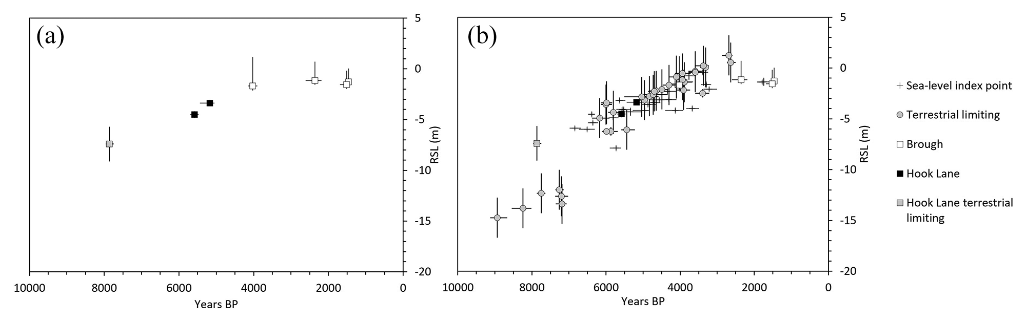
RSL constraints for the inner Humber Estuary (a) from this study and (b) combined with published sea-level index points and terrestrial limiting data, as compiled in Shennan et al. (2018). The Brough data have an upper vertical error included based on the potential sediment compaction rate of 0.6 mm year−1 (Horton and Shennan, 2009) in addition to the vertical error in Table 2.
RSL data from this study.
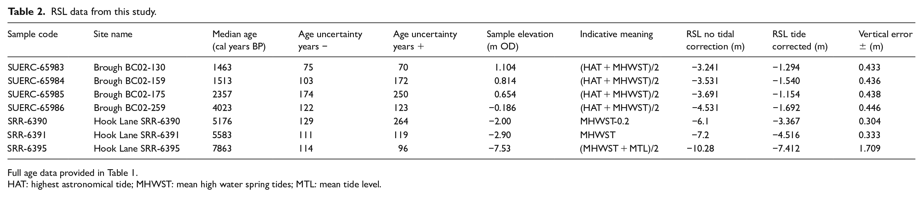
Full age data provided in Table 1.
HAT: highest astronomical tide; MHWST: mean high water spring tides; MTL: mean tide level.
The RSL data from Brough are clearly affected by post-depositional lowering due to compaction. Whilst such intercalated data points provide some broad constraint on RSL, there is no consistent approach to de-compacting sediment sequences. Information to apply such corrections to published SLIPs are not available for sediment records such as these, where heterogeneity creates considerable complexity, and therefore no compaction corrections have been applied. However, an analysis of basal and intercalated data from the Humber Estuary indicates potential sediment compaction rates of 0.6 ± 0.3 mm year−1 (Horton and Shennan, 2009). Such rates would contribute to the process of submergence and infilling experienced by wetlands surrounding the Humber during the Holocene.
System responses to relative sea-level rise and sediment supply
The results from Hook Lane and Brough indicate the role of different driving mechanisms at the estuarine margin, and the relative dominance of local factors and RSL change. Through the mid and late Holocene, as the rate of RSL rise reduced and tidal ranges increased, there is a shift to sediment supply becoming a dominant driver (Figure 6).
Whilst the role of sediment supply would be a factor in peat accumulation in the early Holocene, and the tidal lagoon system that formed at Hook Lane, the rate of RSL rise was integral. Peat formation has a close relationship with water table height, and the rise in RSL would raise water levels and thus influence the formation of basal peats (Allen, 1990; Waller and Kirby, 2021), and the initiation of the floodplain wetland system at Hook Lane. Under the rate of RSL rise experienced however, peat accumulation could not keep pace and was submerged. The local conditions were important, as combined with impeded fluvial drainage, a perimarine tidal lagoon system was formed. Such systems are uncommon, and demonstrates the unique environments that can exist in these marginal estuarine locations and the significant role that local drivers play alongside the backdrop of macroscale changes in RSL.
The capacity of estuarine and adjacent systems to respond to RSL rising at c. 4 mm year−1 can result in a rapid transformation of a landscape. Indeed, the submergence of the Palaeo-Elms valley occurred in as little as c. 200 years during early Holocene rapid RSL rise, as the fluvial system was unable to adjust to the changes, transforming a once fluvial system into a marine system (Hepp et al., 2019). At Hook Lane, a combination of continued RSL rise coupled with changes in tidal range resulted in sediment infilling, the loss of the lagoonal system, and return to wetland conditions, in the space of c. 1000 years.
The persistence of the wetland environment at Hook Lane between c. 6800 and 5500 cal years BP, a time at which RSL was still rising at 3.9mm year-1 in the estuary (Horton and Shennan, 2009; Long et al., 1998), suggests a relative stability and resilience of the system to continuing RSL rise under conditions that would typically be associated with marine incursion. Such long-term stability of fen environments has been reported elsewhere during the mid-Holocene (Waller and Early, 2015; Waller and Marlow, 1994), though the factors behind the ability of fen carr peatlands to persist for such long periods is less clear, as the rate of RSL rise during this period was not constant (Waller and Kirby, 2021). As modern rates of sea-level rise reach those experienced in the mid-Holocene in the Humber (Fox-Kemper et al., 2021; Long et al., 1998; Metcalfe et al., 2000; Palmer et al., 2018), conditions for peat accumulation may be met, and the development of coastal wetlands could feasibly occur in the Humber and potentially in other marcotidal, tide dominated estuaries under similar conditions. Waller and Kirby (2021) provide a summary of the potential opportunities of wetland restoration, and the multiple benefits and ecosystem services they provide as a potential sustainable management solution to future coastal change.
As rates of RSL rise reduced through the mid-Holocene, the capacity for coastal peatlands to regenerate reduced, and the subsequent drying resulted in compaction and a lowering of the sediment surface relative to regional tidal levels. Furthermore, minerogenic sediment loads increased, and the role of sediment supply became a dominant significant driver of change. Reduced rates of RSL rise and increased minerogenic sediment supply lead to the submergence of the coastal wetlands and a transformation of the coastal environment. Such changes were widespread in the estuary and wider North Sea region during this period (Baeteman, 2000; Long et al., 1998; Metcalfe et al., 2000; Waller and Kirby, 2021), though the mechanisms and timings variable. At Brough, the local factors of compaction, generation of vertical accommodation space and sediment supply became the critical factors, with infilling occurring through the late Holocene. The increased sediment supply in the late Holocene is associated with human impact in the catchment (Beckett, 1981; Buckland and Sadler, 1985; Shennan et al., 2003; Smith, 1958). In recent centuries practices such as land reclamation (Heathcote, 1951; Sheppard, 1966) have contributed to the alteration of the sedimentary dynamics, and combined with future climate-driven changes, sediment dynamics could continue to have an impact on estuarine environments.
Future implications of climate-driven RSL rise at the estuarine interface
The impacts of climate change and RSL rise in estuary systems are complex and multi-faceted. Robins et al. (2016) provide a comprehensive review of the different impacts of climate driven changes to estuarine environments and ecosystems. Such impacts include flooding from RSL rise and fluvial sources, as well as changes in the hydro- and sediment dynamics, processes that have been shown to be key in this study to the transformation of the Holocene landscape at the estuarine margin.
Local changes in tidal dynamics have coincided with shifts in the sedimentary environments within the upper Humber during the mid-Holocene, attributed to the creation of accommodation space and altered inundation regimes. Tidal amplitudes are expected to change over the coming centuries, though the exact mechanisms and magnitudes of change are uncertain, and will vary on local scales (Haigh et al., 2020). Indeed, the response of estuaries to RSL rise has been shown to depend on their size, morphology, tidal amplitude and sediment supply, with potentially contrasting outcomes (Leuven et al., 2019). The estuarine margin of the Humber has experienced landscape transformations in response to such changes during the Holocene. These provide analogues of the possible responses under different conditions in the future, and highlight the continued importance of considering sedimentological and morphological processes in assessing coastal system responses (Hamilton et al., 2019).
This regional and local scale context is therefore critical when examining possible future changes. The resilience or vulnerability of tidal wetlands to flooding due to future sea-level rise remains uncertain, with some studies proposing marshes can withstand sea-level rise rates of up to 10 mm year−1 (Kirwan et al., 2016) and others suggesting a high probability of marsh retreat and loss likely to occur when sea-level rise rates are <8 mm year−1 (Horton et al., 2018). Whilst macroscale assessments of coastal response to sea-level rise can help to identify potential trends and areas of vulnerability (Horton et al., 2018; Vousdoukas et al., 2020), by only assessing the driver of sea level, the local scale capacity and responses are not fully captured. Consequently, the evidence-base underpinning coastal management decisions should include both macroscale assessments and local/regional context. This study highlights the capacity for the system responses to differ, and indeed for them to show considerable resilience from that which might be expected when considering large scale drivers like rates of RSL alone. Recognising and incorporating local responses is therefore critical for informing projections of future coastal changes, and providing robust information for coastal management decisions.
The role of local to regional fluvial and estuarine processes, and RSL, have been shown to have contributed to the evolution of coastlines, and integrated studies that encompass the catchment, fluvial, estuarine and coastal systems are needed to support predictions and inform mitigation strategies (Robins et al., 2016). Critically, the contemporary role of landscape and estuarine management within an estuary and catchment will have altered the capacity of the systems to respond at different spatial and temporal scales. Holocene analogues should therefore be used alongside contemporary observations in order to best estimate future changes and inform management decisions on a full evidential basis.
Conclusion
System responses to changes in sediment dynamics and RSL in the margins of a macrotidal, tide dominated estuary have been shown to differ through the Holocene, with important implications for potential future changes. The environmental responses at two sites within the upper reaches of the Humber Estuary through the Holocene are presented. Both sites demonstrate the relative importance of external and internal dynamics contributing to change, with RSL rise dominating early Holocene changes, and regional to local scale internal dynamics becoming increasingly important through the mid to late Holocene against a backdrop of reduced rate of RSL rise. These findings have implications for possible environmental changes in response to future conditions in similar estuarine settings.
Hook Lane records the creation of a wetland environment c. 7800 cal years BP in response to early Holocene rapid RSL rise. The fluvial system was underfit for the magnitude and pace of change (particularly the amount of vertical accommodation space being created by RSL rise, combined with fluvial input), and a tidal lagoonal subsequently system formed. Within c. 1000 years, wetland conditions returned, as the lagoon infilled due to sedimentation and a reduced rate of RSL rise, coupled with changes in the palaeotidal regime. The wetland environment persisted for c. 1300 cal years BP, suggesting some resilience to ongoing RSL rise. At c. 5200 cal years BP, saltmarsh conditions encroach as RSL continue to rise, and freshwater wetlands expand at c. 4400 cal years BP in response to reduced rates of RSL. Brough records wetland submergence from c. 4000 cal years BP and expansion of marine conditions as the estuary approaches its maximum extent. The minerogenic units from c. 4000 to 1500 cal years BP at Brough reflect the contribution of increased sediment loads through the late Holocene, and the interaction of accommodation space creation and ability for wetlands to respond. The new SLIPs and terrestrial limiting point are in good agreement with existing RSL constraints for the region, and the Brough SLIPs cover a time period which previously lacked SLIP constraints, and provides the youngest SLIPs for the inner portion of the Humber Estuary.
The capacity of systems to respond to changes in external and internal dynamics, as well as regional and local controls, is critical. Future changes in estuarine systems will not only depend on the rate and magnitude of RSL change, but also changes in the hydrological and sedimentary dynamics. As contemporary rates of RSL rise approach those experienced earlier in the Holocene, a rate that triggered significant changes in the inner and upper reaches of the Humber, significant challenges for coastal management can be anticipated as the estuary system adjusts. These challenges could be exacerbated by future changes in sediment and tidal dynamics. However, the apparent resilience of the former wetlands suggest potential opportunities for future sustainable management and adaptation if space for the re-creation of coastal wetlands analogous to their Holocene counterparts is considered as a potential tool within the mitigation planning process.
Footnotes
Acknowledgements
We gratefully acknowledge the landowners for providing access to sites. Whilst those who helped with the field data collection are too numerous to mention, the data presented here would not have been possible without their collective efforts, which are sincerely appreciated. The support and encouragement from colleagues associated with the Humber Wetlands Project and Geography staff from the University of Hull (Dr Jane Bunting, Professor David Taylor and Dr Steve Ellis), and University of York, is gratefully acknowledged. We thank two anonymous reviewers for the constructive comments that enhanced this manuscript.
Funding
The author(s) disclosed receipt of the following financial support for the research, authorship, and/or publication of this article: This work was supported by the Natural Environment Research Council (NERC) (NE/J016624/1); a University of Hull PhD studentship and the NERC Radiocarbon Facility (allocation no. 1932.1015).