
Abstract
The term ‘Little Ice Age’ (LIA) is classically used to define a period of repeated and extensive glacier advances during the last millennium. In the meanwhile, this term is also used to address the period of relatively low temperatures between the Medieval Climate Anomaly (MCA), or Medieval Warm Period, and present-day warming. The end of the LIA is generally set to the mid or late 1800s CE, however, the published onset dates of the LIA are more variable from the mid 1200s to the late 1500s. At Mont Miné and Morteratsch glaciers, Swiss Alps, we sampled and subsequently analysed detrital as well as in situ tree remnants from the early LIA period. At both glaciers, trees with lifespans of up to about 400 years were buried at various lateral moraine sites. The corresponding advance of both glaciers can be traced from the 1280s until the 1310s. At Morteratsch glacier, this early LIA advance phase culminated likely around 1375 CE. Evidence collected at both glaciers indicates that the ice surfaces were at least c. 12–15 m from the lateral moraine crests deposited during the maximum extent of the LIA. This suggests a similar (though very slightly weaker) magnitude than later LIA advances at our sites. The advances of Mont Miné and Morteratsch glaciers coincide with relatively cool summer temperatures from the late 1200s to the late 1300s. Taken together, the onset of the Little Ice Age in the Alps can be considered to be c. 1260 CE. The Little Ice Age was not a uniform period, but had several phases as can be derived from the records of Alpine glaciers and summer temperatures. We propose a subdivision of the LIA in the European Alps into an early (1260–1380 CE), an intermediate (1380–1575 CE) and a main (1575–1860 CE) phase.
Introduction
The term ‘Little Ice Age’ (LIA) usually refers to a period of repeated and extensive glacier advances during the most recent Holocene that led to glacier maxima with terminus positions that are well documented for the early and mid 1800s. Today, this term is also used to describe the period of relatively low temperatures following the Medieval Climate Anomaly (MCA; e.g. Mann et al., 2009; Stine, 1994), also named Medieval Warm Period (e.g. Broecker, 2001), and preceding present-day anthropogenic warming (Matthews and Briffa, 2005) and in such cases it is often used without reference to glaciers (Masson-Delmotte et al., 2013). The end of the LIA is usually set to 1850 CE in a palaeoclimate context (e.g. Masson-Delmotte et al., 2013). However, dates used for the onset of the LIA vary much more with starting dates between the 13th and 16th centuries based on glacier and/or palaeoclimate evidence, for example 1250 CE (Solomina et al., 2016), 13th and 14th centuries (Grove, 2004), 1350 CE (Broecker, 2001), 1400 CE (Bradley et al., 2003; Mann et al., 2009), 1450 CE (Masson-Delmotte et al., 2013) and c. 1550 CE (Lamb, 1977). Similarly, its spatial and temporal pattern remains puzzling globally (Neukom et al., 2014). Here we combine both meanings of the term and understand Little Ice Age as the period encompassing (i) the onset of the cooling that caused a glacier advance and a subsequent first maximum of glaciers during the last millennium comparable in dimension to later, historically documented maxima and (ii) the last glacier maximum in the Alps around 1860 CE. Our definition still has a focus on glaciers even if it does not only address deposition dates of moraines in the course of glacier maxima (Grove, 2001), but also includes the advance phase and the climate-related evolution of glacier mass balances that is needed for a glacier to advance and that can be inferred from available climate reconstructions.
In the European Alps, the later phase of the LIA, that is the late 16th to the mid-19th centuries, is reasonably well constrained mainly owing to historical descriptions, maps and drawings of that period (e.g. Nicolussi, 1993; Nussbaumer and Zumbühl, 2012; Nussbaumer et al., 2007; Zumbühl, 1980; Zumbühl and Holzhauser, 1988). In contrast, knowledge on the timing and evolution of the glacier advance at the onset of the LIA is still limited. Due to the lack of distinct historical observations and data, evidence on the state of glaciers is primarily based on field surveys and scientific dating approaches (e.g. Holzhauser et al., 2005; Le Roy et al., 2015; Nicolussi and Patzelt, 2001; Röthlisberger et al., 1980). The most accurate dates for the early LIA have been derived through dendrochronological analysis of trees overridden and buried during glacier advances and the subsequent establishment of calendrical kill dates, that is tree death dates. Information on trees killed by advancing glaciers during the early LIA are, however, only available for a rather limited number of glaciers in the Alps, including the Gepatschferner, Aletsch, Gorner, and Mer de Glace glaciers (Holzhauser, 2009, 2010; Le Roy et al., 2015; Nicolussi and Patzelt, 2001).
Here, we present new evidence on the early LIA evolution at Mont Miné and Morteratsch glaciers, Swiss Alps, through tree-ring based dating of in situ, embedded and detrital tree remnants sampled from prominent lateral moraines. Based on these new results and a compilation of available evidence on the onset and subsequent development of the Little Ice Age in the Alps, and also considering a palaeoclimatic reconstruction, we finally propose a subdivision of the Little Ice Age into an early, intermediate and main phase.
Study sites
Mont Miné glacier (hereafter MM, Figure 1a) is located in the Hérens valley, Valais Alps (46°01′N/7°33′E). It covers an area of 9.67 km2 and has a length of 5.28 km (GLAMOS, 1881–2019; Paul et al., 2020: glacier data state 2015). The lowest and highest positions covered by the glacier were 2122 and 3804 m a.s.l., respectively, in 2015 (Paul et al., 2020). During the LIA maxima, the tongues of MM and adjacent Ferpècle glacier were coalescent, covering an area of 26.9 km2 and extending to an elevation of 1795 m a.s.l. near the hamlet of Salay (Figure 1a). Both glaciers remained connected until 1956 CE. Since then, MM retreated 842 m (until 2019) and the total retreat since the last LIA maximum in the mid 1800s is approx. 2.53 km. Apart from a minor advance between 1892 and 1894 (glacier length change: +11 m) and a phase of slow retreat between 1916 and 1933 (−120 m), which also included a period of stagnation, the general retreat was only interrupted by a re-advance of 134 m in total between 1971 and 1989 (Bezinge, 2000; GLAMOS, 1881-2019; Masset, 2012). Moraines deposited during the stagnation phase and the later advance are still visible (Figure 1a and b).
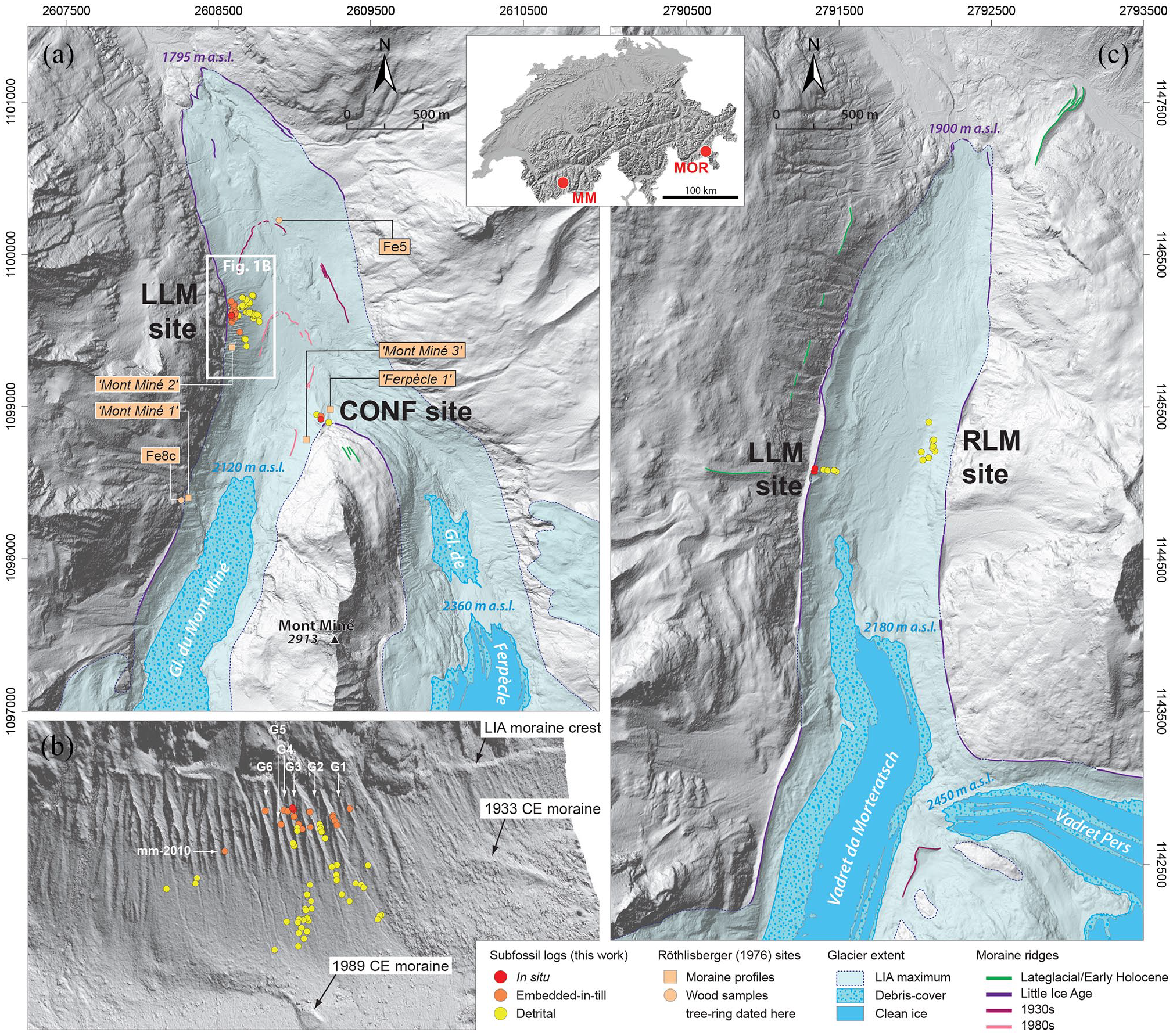
Glacier sites. (a) Map of the Mont Miné glacier (MM) forefield showing the location of the subfossil wood samples at the two lateral moraine (left lateral moraine (LLM) and confluence (CONF)) sites. Also shown are the locations of the Röthlisberger’s (1976) moraine profiles (italic font) and wood samples, of which two were tree-ring dated within this study; (b) 3D-view of the MM left lateral moraine site towards the west based on the SfM DEM (cell size: 0.22 m). All dated samples are shown, irrespective of subsequent tree groupings. Moraine sampled gullies are labelled G1 to G6 (from north to south); (c) Map of the Morteratsch glacier (MOR) forefield showing the location of the subfossil wood samples at the two lateral moraine sites (left and right lateral moraine (LLM, RLM)). Shown glacier extent is 2020 for MM and 2019 for MOR based on the analysis of recent orthophotos, and the hillshade background map in (a) and (c) is based on swissALTI3D (courtesy of Swisstopo). Coordinates are in metres of the Swiss Grid system (LV95).
The retreat of glacier ice since the end of the LIA has exposed two large and steep lateral moraine complexes, one on the true left side of the glacier forefield, overlooking the 1989 terminal moraine, and one at the former confluence, hereafter confluence site, of the MM and Ferpècle glaciers. With a maximum relief of almost 180 m with respect to the alluvial plain and a length of some 450 m, MM’s left lateral moraine is a prominent landform and stands as one of the best examples of deeply gullied Neoglacial moraines in the Alps (Curry et al., 2006).
First mentions of sampling at MM comes from Röthlisberger (1973, 1976) who visited and sampled subfossil wood and fossil soil layers in the Mont Miné/Ferpècle glacier forefield in 1971. Röthlisberger found, described and dated four sections, mainly at the left lateral moraine and confluence sites (Figure 1a). Radiocarbon-dated fossil soils obtained during this work highlighted three main periods of glacier advance over the last 2500 years, namely at 2.5, 1.9–1.5, and 0.8 ka. The recent retreat of MM has exposed further, early Holocene tree remnants (Hormes et al., 2001; Nicolussi and Schlüchter, 2012). Nicolussi and Schlüchter (2012) could thereby reconstruct the course of the glacier advance in the context of the ‘8.2 ka event’ based on long lived and large logs found on the MM alluvial plain at c. 2000 m a.s.l. (Figure 1a). Their work was the first to evidence a glacier advance in the Alps at that time.
The retreat of MM has exposed steep morainic slopes and allowed the resulting erosion to uncover wood and soil layers that were buried by earlier glacier advances in both lateral moraine complexes. At the left lateral moraine site, these erosional processes have formed a series of deep gullies in the upper part of the lateral moraine, that is between c. 2050 m a.s.l. and the moraine crest extending downhill from approximately 2160 to 2120 m a.s.l., whereas the slope below is covered by eroded moraine sediments (Figure 2). At the gully section, erosion has exposed trees that are still standing upright as well as stem sections that were usually embedded horizontally in the moraine (Figure 2f). Some of these logs lie directly over a fossil soil, with the latter often containing a root horizon (Figure 2g). The soil layer separates the sediment unit with the tree remnants from an underlying, older sediment body. Detrital tree remnants were also observed on the talus below the gully area (Figure 1b). At the confluence site, in situ tree remnants (Figure 2c) have been recently exposed in the actively eroding section, between c. 2120 and the top of the moraine at c. 2170 m a.s.l. However, the number of such finds remains limited in this area.
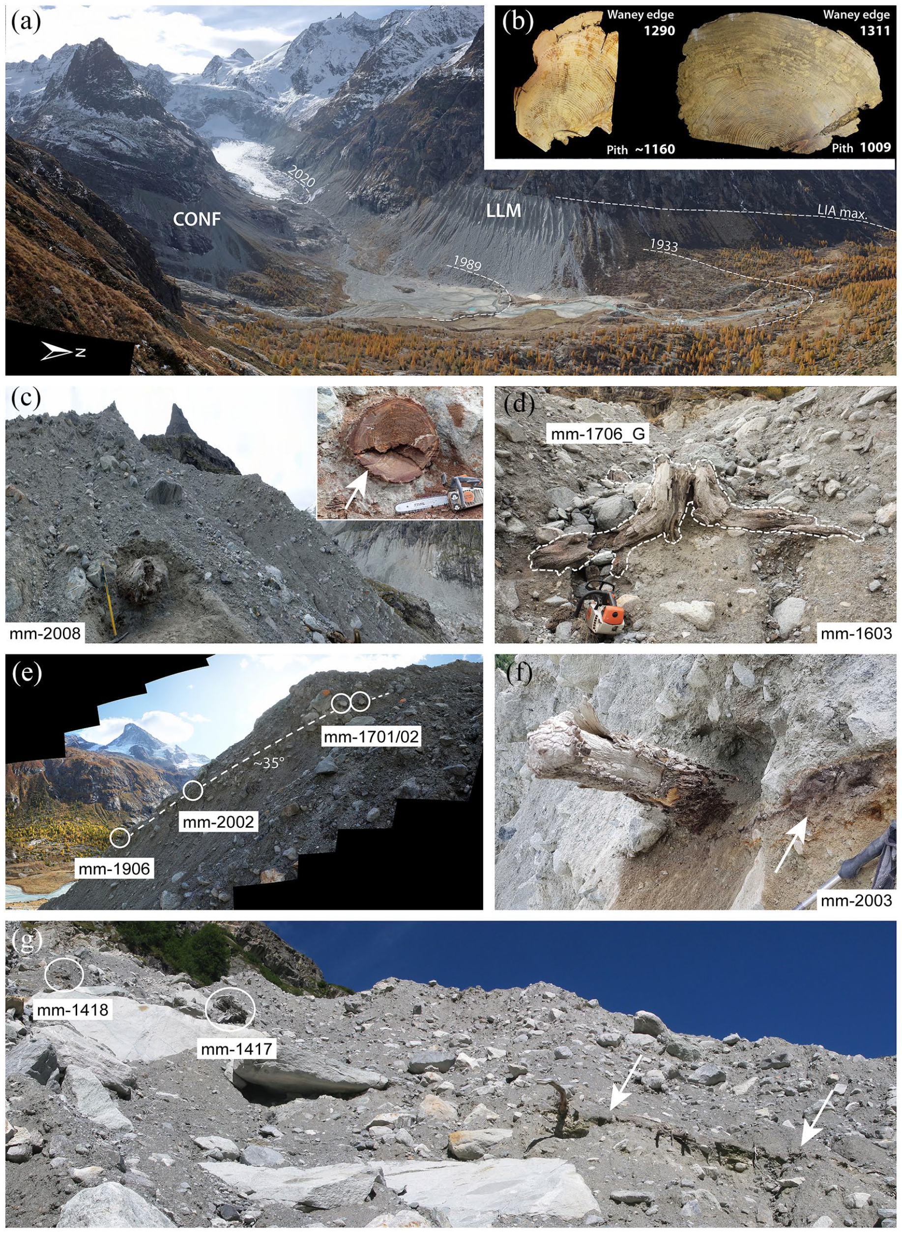
Mont Miné glacier and sampling locations. (a) Panorama of the Mont Miné glacier forefield from the path to Bricola hut (view is towards the south-west, photo taken on 22.10.2020). The left lateral moraine and confluence sampling sites are highlighted, as are the 1989 and 1930s glacier front locations (stadial moraines); (b) Left lateral moraine (LLM) site: close up views of a Cembran pine (mm-1909, left) and a European larch (mm-1707, right) sample; (c) Confluence (CONF) site: larch log mm-2008 after excavation (pick ~0.9 m long for scale). This tree was killed by the glacier in late 1285 CE (latewood is present). Inset shows the pristine thick bark (~5 cm) preserved over the entire circumference of this log indicating it can be considered as near in situ, despite being uprooted; (d) Left lateral moraine site: in situ stumps mm-1603G (foreground; kill date: 1260+ CE) and mm-1907G (background; kill date: 1274+ CE) of Cembran pines found 3 m apart in Gully 3; (e) Left lateral moraine site: location of the embedded-in-till samples from the southern wall of Gully 1. The dashed line highlights the stratigraphic discontinuity (woody debris-rich layer) dipping ~35° and represents the distal palaeo-moraine face at the time the logs were buried. Dent Blanche (4357 m a.s.l.) is visible in distant background; (f) Left lateral moraine site: Cembran pine mm-2003: embedded log lying in contact with a palaeosol (arrow) in Gully 2; (g) Left lateral moraine site: European larch mm-1417 (kill date: summer 1293 CE) and Cembran pine mm-1418 (1238+ CE) sampled in the northern wall of Gully 3. Note the pronounced root and wood horizon running downslope, separating the older from the younger moraine deposits (arrows).
Morteratsch glacier (Vadret da Morteratsch, hereafter MOR, Figure 1c) is located in the Bernina Range (46°23′N/9°56′E; c. 180 km east of MM). It covers an area of 7.87 km2 (without its former tributary Pers glacier (6.72 km2), disconnected from MOR since 2015) and has a length of 7.04 km (GLAMOS, 1881–2019; Paul et al., 2020; glacier data state 2015). Lowest and highest elevations of the glacier were 2089 and 3985 m a.s.l., respectively, in 2015 (Paul et al., 2020). During the LIA maxima, MOR reached an elevation of 1902 m a.s.l. and covered an area of 19.3 km2 (Figure 1c). The last LIA maximum of MOR occurred between 1857 and 1862 (Beeler, 1977; Holzhauser, 2010; Maisch et al., 1993). The latter date is based on tree-ring dating of two trees located in the LIA moraine (of which one was in situ) and killed that year (Holzhauser, 2010). This maximum occurred slightly later than at many other Alpine glaciers. By 1870, the glacier front had barely retreated (R. Fontaine, 2021, personal communication) and by 1878, when first length surveys were carried out, the front was only 75–100 m inboard of the LIA maximum. Since then, ice retreat has increased to nearly 3 km, about 65% of which has occurred since 1950 (GLAMOS, 1881–2019). In contrast to MM, retreat at MOR since the late 1800s has only been interrupted by a standstill in the 1980s but not by any significant advances, highlighting a longer volume response time at MOR of c. 32 years (Zekollari et al., 2014). MOR is a benchmark site for glaciological research (Klok and Oerlemans, 2002; Nemec et al., 2009; Zekollari and Huybrechts, 2018) and has more recently also become a key site for geoengineering investigations (Oerlemans et al., 2017). Recent mass balance measurements, available for the period 2001/02 to 2019/20, document a mean mass loss of 0.956 m w.e. per year (GLAMOS, 1881–2019). The well documented retreat as well as the homogeneous and wide forefield of MOR have favoured widespread plant succession and soil development studies in a newly ice-free area (e.g. Burga, 1999; Burga et al., 2010; Egli et al., 2006). In addition, Fitze (1980, 1982) investigated a moraine wall located just outside the mid-19th century end moraine. This older moraine wall is built up of two depositional units, clearly separated by a fossil soil. Radiocarbon dating of the soil material yielded an early medieval age and suggests a moraine deposition and glacier maximum, just exceeding the later LIA maximum extent, around 900 CE.
About 2 km inside the glacier forefield, huge lateral moraines are formed on both sides (Figures 1c and 3). The current moraine crests are located at c. 2190 m a.s.l., that is c. 190 m above the present-day valley floor. The steep upper sections of the two lateral moraines are currently eroding and debris is accumulating on newly forming slopes. This erosion is uncovering logs that were previously buried in the moraine (Figure 3). While in the true right lateral moraine only detrital logs were accessible for sampling (Figure 3b), two upright standing tree trunks could be sampled at the left lateral moraine by rappelling down from the crest (Figure 3c–f). Sampling of detrital logs lying on the talus below the two upright standing trunks was also carried out.
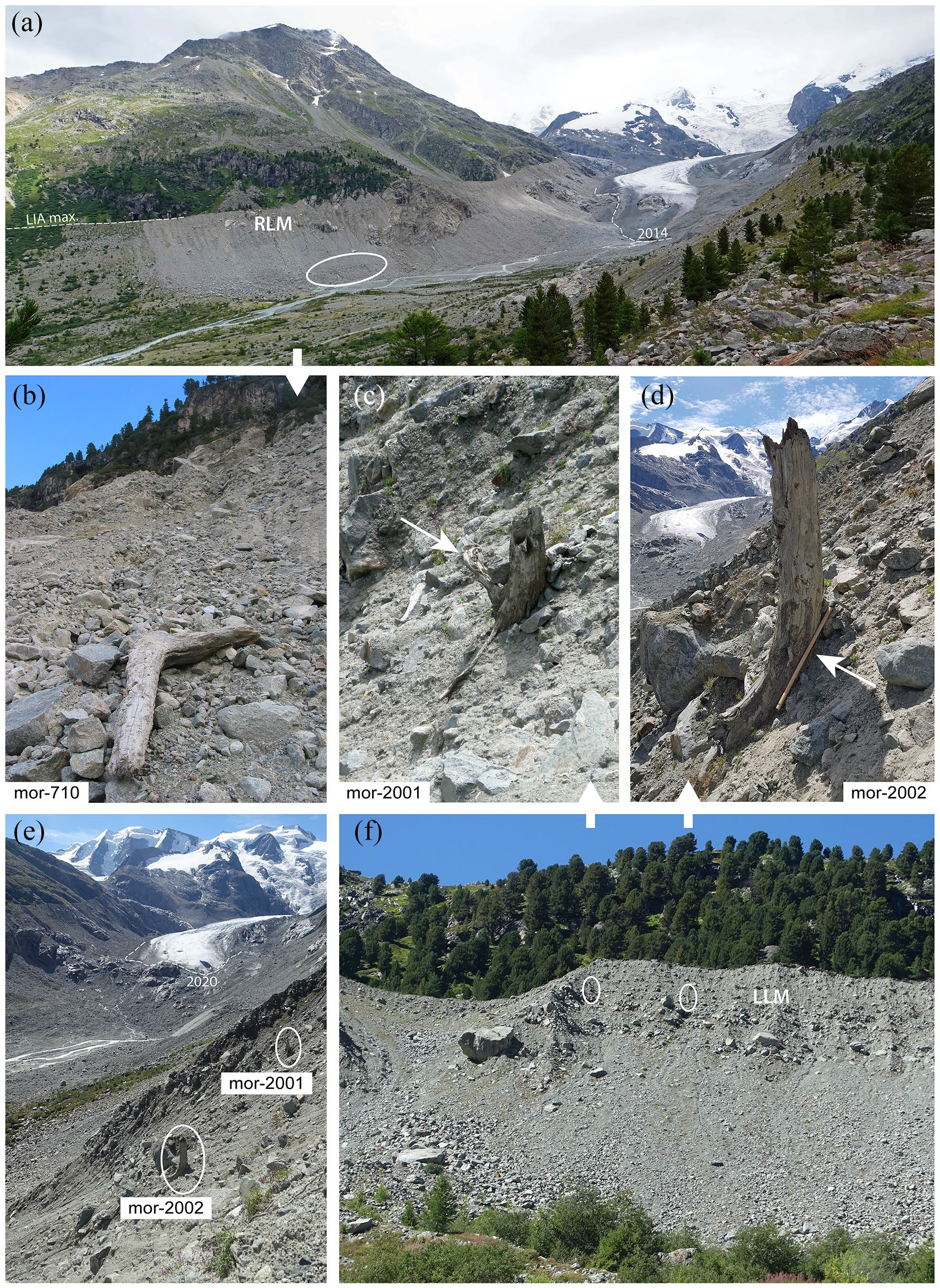
Morteratsch glacier and sampling locations. (a) Overview of the Morteratsch glacier forefield from the LIA left latero-frontal moraine complex (view towards the south-east, 19.08.2014). The right lateral moraine (RLM) sampling site (containing detrital logs only) is highlighted with an ellipse; (b) Right lateral moraine: detrital log mor-710; (c) The Cembran pine (mor-2001) in situ stump from the left lateral moraine. The arrow points to a root extending farther upslope, proving that this tree was growing on the former distal face of the lateral moraine (LLM); (d) The European larch (mor-2002) in situ stump from the left lateral moraine (pick ~0.9 m long for scale). The arrow points to pristine patches of bark at the interface with sediments; (e and f) show the locations of the in situ stumps mor-2001 and mor-2002 in the upper part of the left lateral moraine sampling site. The view is towards south in (e) and towards west in (f).
Methods and material
During several campaigns between 2007 and 2021, samples of logs were collected for tree-ring analyses at MM and MOR. At MM, over the period 2007–2020, progressive erosion of the lateral moraine led to gradual liberation of subfossil trees, with new samples appearing every year. Sampling was carried out by systematically exploring all the gullies from bottom to top at the left lateral moraine site and was exhaustive within the limits of accessibility (Figure 1b). Samples located in unstable sectors of a gully were not initially collected (for safety reasons), however, in subsequent years erosion often caused these samples to come loose and where they fell onto the underlying talus, they were sampled in subsequent years. Most samples were found in the first six of the active northern gullies (Figures 1b and 2). Stratigraphical context was recorded next to embedded samples, such as fossil soils or litter layers. At least one slice was recovered per sample, along with several outer fragments. Care was taken to sample the best-preserved part of the logs to maximise identification of the last rings present.
The status of the sampled logs (i.e. detrital, embedded or in situ), was identified in the field. Most logs sampled had to be classified as detrital as they were displaced from their place of growth or embedding due to recent erosion. Several logs could be sampled ‘embedded-in-till’, that is at the position where the tree was deposited by the advancing glacier, and in situ, that is rooted at growth position, or ‘virtually in situ’, that is not rooted but showing little or no evidence of displacement from the place of growth (Figures 2 and 3). Most of the large (i.e. whole trunks preserved) embedded logs retain pristine waney edge, that is the last ring formed before the death of the tree, and extensive bark patches. We therefore interpret these specific tree remnants as little to barely reworked after their burial in glacial deposits (e.g. Figure 2c).
In the field, locations and elevations of the finds were determined by GNSS and/or barometric measurements and field descriptions. During recent years, elevation of the samples was recorded in the field with a Trimble dGPS device for the embedded samples and a Garmin hand-held GPS for the detrital samples. Data were then imported into a precise DEM to confirm elevation data (Figure 1). At both glaciers, detrital samples were found down to the lowest part of the talus scree and were sampled to complement and refine data obtained from embedded samples.
Tree-ring measurements to the nearest 1/100 or 1/1000 mm were carried out with LINTAB devices and the TSAP-Win software (www.rinntech.de). Several radii were usually measured per sample and additional investigations included wood species determination, identification of possibly preserved sapwood and waney edge as well as, if necessary, pith-offset (PO) estimates for samples with missing piths. Identification of waney edges was challenging due to the usually eroded outermost wood part of the sampled logs. Dendrochronological dating was carried out on the basis of local and regional tree-ring series and chronologies, including the Eastern Alpine Conifer Chronology (Nicolussi et al., 2009) as well as chronologies from the Mont Blanc region (Le Roy et al., 2015). Dendrochronological dating was carried out by statistical and visual comparisons of sample series with reference datasets and chronologies. For the statistical crossdating, Gleichläufigkeit (sign test), pointer year interval Gleichläufigkeit as well as t-values were calculated by utilising the software TSAP-win (www.rinntech.de) (e.g. see Supplemental Figure S2).
For a few samples, whose tree-ring series could not be unambiguously dated by dendrochronology in a first step, radiocarbon dating was also carried out (Table 1). Calibration of single 14C dates as well as wiggle matching calibration were carried out using OxCal version 4.4 (Bronk Ramsey, 2009; Bronk Ramsey et al., 2001) and the calibration curve IntCal20 (Reimer et al., 2020). In the text, only the median results or the two σ ranges (especially for older radiocarbon dates with large standard deviations) of the 14C calibration results are given and noted as ‘cal CE’.
Radiocarbon ages and single as well as wiggle-matching calibration results for MM and MOR samples.
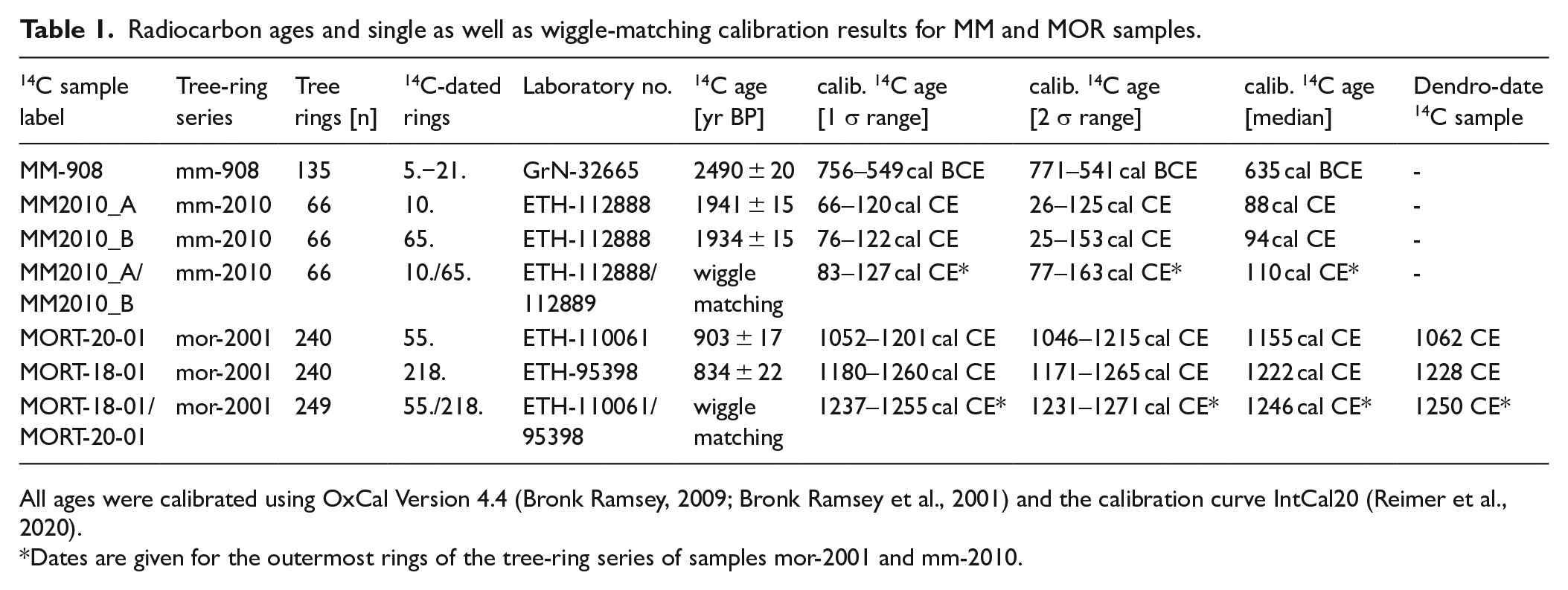
All ages were calibrated using OxCal Version 4.4 (Bronk Ramsey, 2009; Bronk Ramsey et al., 2001) and the calibration curve IntCal20 (Reimer et al., 2020).
Dates are given for the outermost rings of the tree-ring series of samples mor-2001 and mm-2010.
Our tree-ring series dataset is based on 69 logs and 23 logs sampled at MM and MOR, respectively (Supplemental Table S1). Additionally, we re-analysed two slices collected by F. Röthlisberger in 1971 (Röthlisberger, 1973, 1976; Figure 1a) and stored in the archive of Service Régional de l’Archéologie (SRA 13, Aix-en-Provence, France). Calendar dates for dendrochronologically dated samples are usually given for the outermost tree ring assessed. This includes an indication whether a waney edge could be identified and an exact kill date of the tree can be given, or whether outer rings were eroded and the tree’s death therefore occurred after the calendar year given by the last ring present on the sample. In such cases, a ‘+’ sign is added to the calendar year indicated.
Given that we repeatedly sampled short and also relocated stem sections, we cannot exclude the possibility that multiple samples were obtained from a single tree. In order to limit the risk of over-sampling, we established sample groups according to wood species, waney edge date (if available), growth level, growth trend as well as variability of the tree ring series indicated by the crossdating values (e.g. Supplemental Figure S1 and Table S2). This step is challenging when it comes to comparing treeline larch series, which usually feature very similar growth rates as well as high inter-tree crossdating values, mimicking possible intra-tree correlation levels. In the case of ambiguous inter-tree correlations, we preferred to avoid grouping, which may result in a slightly overestimated number of sampled trees.
Results
Mont Miné glacier
At MM, embedded and in situ logs were usually found in direct contact with a palaeosurface (Figure 2). Outcrops of this moraine palaeosurface with a partly significant soil layer can be traced on both MM walls and in almost every gully we visited. Dip readings of this palaeosurface were realised at different locations and yielded a mean of c. 36°.
In total, 69 samples of tree remnants (49 Larix decidua, 20 Pinus cembra) were retrieved from the left lateral moraine and confluence sites at MM (Supplemental Table S1). These samples were grouped into 35 single ‘trees’ (Figure 4). Almost all samples collected at these sites date to the Medieval Ages and the associated tree-ring series cover the period 908–1311 CE continuously. Confirmed and estimated pith dates for grouped and individual samples spread between 908 and 1193 CE. Younger dates (post c. 1150 CE) were found primarily in small samples (branches) and do not reflect close germination dates of the related trees. Outermost and waney edge dates of the MM medieval logs fall with one exception (mm-2009) into the period 1204+ to 1311 CE. Larch colonisation of the moraine surface (c. 900 CE) occurred roughly 150 years earlier than first evidence of Cembran pine germination (c. 1060 CE) (Figure 4).

Temporal distribution of dated logs from the left lateral moraine (LLM) and confluence (CONF) sites at Mont Miné (a) as well as the left and right lateral moraine (LLM, RLM) sites at Morteratsch (b) and germination dates as well as outermost or tree-death dates of the logs (c). Only individual series or grouped series found to belong to an individual tree are shown here (see Supplemental Table S1 for a comprehensive list of samples and grouped tree-ring series). Decadal to multi-decadal long phases of suppressed growth (consistently <0.15 mm tree-ring width), interpreted as indicators of glacial proximity, are displayed for several MOR samples. LADE: Larix decidua, European larch; PICE: Pinus cembra, Cembran pine; W: waney edge (i.e. the last tree ring formed before the tree died is present); WL: latewood is formed on the last ring present, indicating tree death during autumn or winter following the formation of the last ring; WE: only earlywood is formed on the last ring present, indicating tree death during the summer period; WX: waney edge is present but a seasonal kill date cannot be obtained for the last ring formed; W?: waney edge is likely present.
The earliest waney-edge date, 1265 CE, was established for a detrital log (mm-1114, Supplemental Table S1). However, this has to be classified as a local death date for the cambium because another sample (mm-1101, Supplemental Table S1) belonging to same tree group provided a longer series (outermost ring 1270+). The other waney edge dates are recorded between 1285 and 1311 CE. All pre-1285 dates falling into the first half of the 1200s are termini post quem for tree-death dates and likely only reflect outer abrasion of the recovered wood fragments. The 1285 CE tree-death date originates from an in situ log (mm-2008, Figure 2c, Supplemental Table S1) sampled 30 m below the crest of the lateral moraine at the confluence site. The 1311 CE tree-death date was established for a log at the left lateral moraine site embedded 38 m below the local moraine crest (mm-1707, Supplemental Table S1). The year 1290 CE is exceptional as at least five trees were killed during the summer of this year and the following autumn/winter period (Figure 4).
Thanks to the presence of in situ and embedded samples, the late 13th century advance of MM can be reconstructed (Supplemental Figure S3). In 1285 CE, this advance reached an ice level c. 30 m below the LIA maximum moraine crest at the confluence site. At the left lateral moraine site, trees were killed by the advancing glacier at least from summer 1287 onwards. Around 1290 CE, the ice surface was less than 33 m below the local LIA crest. The advance continued during the following decades as additional sampled logs demonstrate with waney edge dates in 1293, 1297, 1301 and 1311 CE (Figure 4, Supplemental Table S1). The fact that at least five trees were killed during the summer season reinforces the attribution to burial by a glacier advance. The last recorded death date of 1311 CE (mm-1707, Supplemental Table S1) provides a minimum date for the first LIA maximum at MM. The rise of the glacier surface at the left lateral moraine site can be traced up to 29 m below the moraine crest of the LIA maximum. It remains unclear, however, how high the glacier surface has risen in the further course of the advance after 1311 CE as we have not found any evidence, that is in situ or embedded logs, in this regard. Though, the detrital log mm-2007 found at confluence site only 16 m below the crest and dated 1274+ CE (no waney edge) likely indicates that the early LIA advance reached almost the level of the current moraine crest and was thus similar to later LIA levels at MM (Supplemental Figure S3).
Our Late-Holocene MM dataset includes four samples whose ages differ from the high medieval samples. For a detrital Cembran pine log (mm-908, Supplemental Table S1), sampled at the left lateral moraine site in 2009, a radiocarbon age was established which dates it back to the first millennium BCE (Table 1). This log likely documents the c. 600 BCE advance period at MM, which was accurately dated elsewhere in the Alps (Holzhauser et al., 2005; Le Roy et al., 2015; Nicolussi and Patzelt, 2001). Also at the left lateral moraine site, we sampled an embedded Cembran pine log (mm-2010) 74 m below the local moraine crest (Figure 1b). The sample is partly decayed, but a preserved waney edge indicates that the tree died during the early summer season. Radiocarbon dating demonstrates that tree mm-2010 grew in the early Roman period (Table 1). No glacier advances or maxima have been documented in the Alps for this period, hence the death of this individual tree should not be interpreted as the result of glacier activity. It is more likely that a debris flow in the area of the steep lateral moraine caused its death and burial.
Two further wood samples were collected in 1971 by Röthlisberger (1973, 1976) and can now be dated dendrochronologically. The older sample (Fe5, Supplemental Table S1) was collected within the glacier forefield at the valley bottom (1970 m a.s.l.), slightly outboard of the glacier’s frontal position in the 1930s (Figure 1a). The sampled Cembran pine tree lived at least c. 300 years (tree-ring series 304–578 CE, Supplemental Table S1) and the analysis yielded an outermost date of 580+ CE (no waney edge). This tree had probably been covered by the advancing tongue during the glacier advance phase of the sixth century CE (Holzhauser et al., 2005; Le Roy et al., 2015) and suggests a corresponding advance at MM which probably exceeded its 1930s extent. The youngest MM sample (Fe8c; Figure 1a, Supplemental Table S1) was obtained from a location just outside of a lateral moraine ridge on the true left side of the forefield (Röthlisberger, 1973, 1976). At the sampling place, this log was probably in situ. Its pith date of 1309 CE falls into the first LIA advance at MM and the tree died during the main LIA phase shortly after 1700 CE. The tree-ring series does not indicate major growth depressions or disturbances during the 1300s as one could expect for a tree growing in the proximity of a glacier (Holzhauser, 1984; Nicolussi and Patzelt, 1996). Therefore, the missing growth disturbances can be taken as an indication that the glacier surface was not close to the site at which the tree was growing during the early LIA or that the tree remnant was not found in situ.
The advance at the onset of the LIA can be traced at MM by a series of logs that provided death dates ranging between 1285 and 1311 CE. European larch and Cembran pine trees grew during this period on stabilised moraine deposits. The c. 400 years episode during which a forest could grow at the left lateral moraine site during the MCA was terminated by this advance. The glacier surface reached a height that was only 16 m or less below the crest of the later LIA maximum (Supplemental Figure S3), however, the final extent and maximum date of this first LIA advance of MM remains unknown.
Morteratsch glacier (MOR)
At MOR, 23 wood specimens (21 detrital tree remnants and two in situ trunks) were retrieved of both Cembran pine and European larch (Supplemental Table S1). They were grouped into 17 individual ‘trees’ (Figure 4). The two in situ trunks (Figure 3) are located 13 and 12 m below the current crest of the left lateral moraine (Figure 5; Supplemental Figure S3). However, the ridge of the lateral moraine has been eroded since the end of the LIA and the former crest was probably c. 5–10 m higher (Figure 5). The outer part of the in situ trunk mor-2001, located closer to the glacier (2180 m a.s.l., Cembran pine), was heavily weathered, accordingly the tree-ring series ends without a waney edge in 1256+ CE (pith date: 1010 CE). The larger stump (mor-2002; 2177 m a.s.l., European larch), located at about the same elevation but c. 20 m downvalley, yielded a pith date at 928 CE and, depending on the side of the trunk, different local waney edge dates. While the cambium on the glacier-proximal side of this tree already died off after forming the waney edge in 1311, the corresponding date on the slope side is 1317 CE. The tree-ring sequence of mor-2002 also shows a marked decline in growth from about 1300 CE onwards.
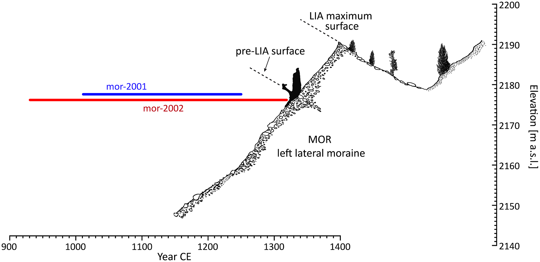
Sketch of the situation of the upper part of the left lateral moraine of Morteratsch glacier (MOR) with the sampling site of the in situ trunks mor-2001 and mor-2002. The upright orientated root of mor-2001 indicates that these trees grew on the distal slope of the pre-LIA left lateral moraine. The temporal extension of the tree-ring series established for these two trunks are given. The size of the subfossil stump and recent trees are not in scale.
The detrital logs at the left lateral moraine were sampled in the talus deposits approximately in the fall line below the two in situ stems. With one exception, their ages overlap with the lifetime of the two in situ trunks, but the waney edge is most likely only preserved on one dated sample (mor-1502, probable death date 1281 CE). The outermost rings of the other samples mostly date between 1268 and 1283 CE (Supplemental Table S1). The associated trees grew up after 900 CE. One detrital sample (mor-1504, Cembran pine) from the MOR left lateral moraine site yielded a deviating dating result with an outermost ring date (no waney edge) of 517+ CE (pith date 272 CE). This log documents arguably the sixth century glacier advance period (Holzhauser et al., 2005; Le Roy et al., 2015) at MOR during which the tree was most likely killed as well as embedded and subsequently preserved in moraine sediments.
The early LIA advance of MOR can be reconstructed with these samples from the left lateral moraine site. The advancing glacier killed tree mor-1502 (probable death date 1281 CE) already in the 1280s and reached later the elevation and crest of the pre-LIA lateral moraine where it subsequently impacted the two trees mor-2001 and mor-2002 growing on the outer side of this moraine (Figure 5). This is indicated by the orientation of the root plate of the in situ Cembran pine trunk (mor-2001, Figure 3c) as well as by the slight curvature of the lowest part of the European larch trunk (mor-2002, Figure 3d). After reaching the crest of the pre-LIA moraine, the glacier spilt material onto the outer side of the moraine. According to the marked growth decline found in mor-2002, this occurred around the year 1300 and subsequently led first to the death of the cambium at the glacier-proximal side of the European larch in 1311, whereas the tree continued to form rings on the distal side until 1317 CE.
At the right lateral moraine of MOR, 15 detrital samples were found of which 14 samples could be dendrochronologically dated. The associated tree-ring series cover the time window 852–1603 CE (Figure 4, Supplemental Table S1). Most of the analysed logs from the right lateral moraine site survived the early LIA advance. Only two trees (mor-1505; mor-1508G: samples mor-706, mor-1508 and mor-2108) provided outermost ring dates prior to 1400 CE. Pith dates of these samples are c. 817 (mor-1508G; estimated) and 1004 CE (mor-1505). Whereas the tree-ring series of one tree (mor-1508G, no waney edge) ends already in 1222+ CE, the other tree (mor-1505) died c. 1375 CE (waney edge with bark). The related tree ring series of mor-1505 ends already in 1365, the tree rings of the following outermost section of the sample could only be counted (about 10 rings) due to compressed wood. Considering the well-preserved wood of mor-1505 (implying a rapid burial within the moraine after or in the course of tree death), it is likely that this sample documents the prolongation and maximum of the glacier advance from around 1300 CE. Some of the samples from the right lateral moraine site, namely mor-709, mor-1505 and mor-2109, show remarkable small tree rings with measures constantly below 0.15 mm over decades in the late 1200s and/or in the 1300s (Figure 4). We interpret these phases of suppressed growth as a consequence of the proximity of the glacier to the trees’ growth locations (Holzhauser, 1984; Nicolussi and Patzelt, 1996) and thus as indirect evidence of elevated ice surfaces.
Several detrital samples from the right lateral moraine of MOR yielded later dates for the outermost rings, dating them to the 15th and 16th centuries (Figure 3, Supplemental Table S1). It can be assumed that these logs (assessed on the site situation as well as on the basis of preservation status) were buried during a maximum of MOR in the early 17th century.
Discussion
The early LIA advance at Mont Miné and Morteratsch glaciers
Tree-ring analyses of subfossil tree remnants at MM and MOR demonstrate a synchronous glacier advance from the 1280s onwards. At MM, this advance certainly lasted until the 1310s, however, the date of its maximum remains uncertain. At MOR, this advance persisted also at least until the early 1300s and likely reached its maximum around 1375 CE. At both glaciers, the advance from the 1280s to 1310s is confirmed by in situ trunks and tree remnants whereas the c. 1375 CE maximum at MOR is based on a detrital log only. We also find that around 1310 CE, ice surface elevations were already at a level that was only c. 16 m and 12–13 m or less below present moraine crests at both MM and MOR, respectively. However, the ice surface elevations as well as the length extent at the end of the early LIA phase in the 1300s remains unknown for both MM and MOR.
Tree germination at both the left lateral moraine and confluence sites at MM and at the left lateral moraine site at MOR occurred largely synchronously; they can be traced from the early 800s CE onwards. This finding allows us to precisely constrain the multi-centennial glacier retreat phase during the MCA. At both glaciers, trees were growing on older moraine deposits, found on the proximal side of the left lateral moraine at MM, and on the distal side of the left lateral moraine at MOR. The older moraine within the MM left lateral moraine is separated from the moraine sediments placed during the initial LIA advance by a soil which is clearly visible in various places (Figure 2e–g). Dip readings of the palaeosurface of this older moraine yielded a mean of c. 36° which is consistent with a stabilised proximal moraine face (e.g. Curry et al., 2009; Lukas et al., 2012).
The fossil soil layer at the MM left lateral moraine was already described and subsequently dated by Röthlisberger (1976:76; Röthlisberger et al., 1980: soil Mont Miné 2, located c. 30 m below the erosion edge of left lateral moraine; Figure 1a). The calibration results of the two obtained 14C ages (2 σ: 724–1151 cal CE and 668–1406 cal CE; Supplemental Table S3) overlap with the growth period of the MCA forest at the left lateral moraine site and confirm that this soil layer formed in fact the forest floor at that time. A similar 14C age (1029–1256 cal CE; Supplemental Table S3) was obtained by Röthlisberger (1976) for soil 3 of the profile Mont Miné 3 at the confluence site (Figure 1a) which allows us to infer a concurrent formation of soils at these two profiles. The deposition of the moraine unit on which this soil 3 developed at the confluence site is dated by European larch logs embedded in the sediments about 3 m below soil 3. The calibrated 14C age of one of these logs falls in the middle of the first millennium CE (408–640 cal CE; Supplemental Table S3). A further calibrated 14C age, almost coinciding with the dating of this log just mentioned, is available for another fossil soil located in the true left moraine of MM, about 1 km towards the glacier from the left lateral moraine site (Röthlisberger, 1976: 73): This soil Mont Miné 1 (Figure 1a) was sampled about 15 m below the erosional edge of the LIA lateral moraine and also dates to about the middle of the first millennium CE (261–663 cal CE; Supplemental Table S3). Both the European larch log at profile Mont Miné 3 as well as the soil Mont Miné 1 dates an advance of MM in the middle of the first millennium CE that is also proven elsewhere (Holzhauser et al., 2005; Le Roy et al., 2015). The relocated log found and sampled by Röthlisberger in 1971 on the glacier forefield at 1970 m a.s.l. (log Fe5; Röthlisberger, 1976) shows a date of 580+ CE (Supplemental Table S1) for the outermost ring, and thus a result similar to the two mid-first millennium 14C calibration results. The tree-ring date now established for this log suggests that the maximum of the mid-first millennium CE advance of MM occurred more precisely in the late sixth century at the earliest and led to the moraine deposition at the confluence site as well as burial of the soil at the site Mont Miné 1. The elsewhere evidenced, but later, glacier advance in the early ninth century CE, culminating at c. 840 CE (Holzhauser et al., 2005; Nicolussi et al., 2006), was possibly not pronounced enough at MM to reach a large enough glacier dimension to bury the former moraine deposits.
Similar results can be inferred at MOR. Two trees that were growing on the distal side of the pre-LIA left lateral moraine could be sampled as still rooted and upright standing trunks (Figures 3 and 5). One of them, tree mor-2002, germinated around 900 CE. It cannot be entirely excluded that the deposition of the lateral moraine forming the growth base of these trees occurred approximately 840 CE and thus only a few decades before the germination of tree mor-2002. The absence of any trees with germination dates prior to c. 800 CE at the MOR left lateral moraine site could therefore be considered as an indirect evidence for the deposition of a pre-LIA left lateral moraine during a glacier maximum in the ninth century instead. However, it seems more likely that the deposition of the pre-LIA left lateral moraine dates back to the c. 600 CE advance period. The detrital log mor-1504 found on the talus underneath the in situ trunks mor-2001 and mor-2002 has a death date after 517 CE and this allows inferring an advance and early-medieval maximum at MOR during which log mor-1504 was buried and preserved in moraine sediments.
At both glaciers, we find no unequivocal evidence for a glacier advance related to the early ninth century glacier advance period, even if germination dates of trees at MM as well as at the left lateral moraine site at MOR starting from the about 900 CE onwards could be interpreted as an evidence for a glacier advance that took place shortly before. Both glaciers also lack clear signs for a high-medieval advance phase (HMAP) in the 12th century. Evidence for such a HMAP culminating at c. 1170/80 is available, for example for Gepatschferner, Mer de Glace and Lower Grindelwald glaciers (Holzhauser, 2016; Le Roy et al., 2015; Nicolussi and Patzelt, 2001; Table 2). At both MM and MOR, presumed glacier reactions during the 12th century have not resulted in reaching trees that were subsequently buried during the first LIA advance around 1300 CE. However, there is some probability that tree mm-2009 sampled at the confluence site could have been buried during a pre-LIA event, that is during the 12th century, reaching ~40 m below the moraine crest (Supplemental Figure S3). This sample provided an outermost date of 1114+ CE whereas all other outermost and waney edge dates at MM fall into the period 1204+ to 1311 CE. It can thus be assumed that the death of tree mm-2009 may have occurred during the HMAP.
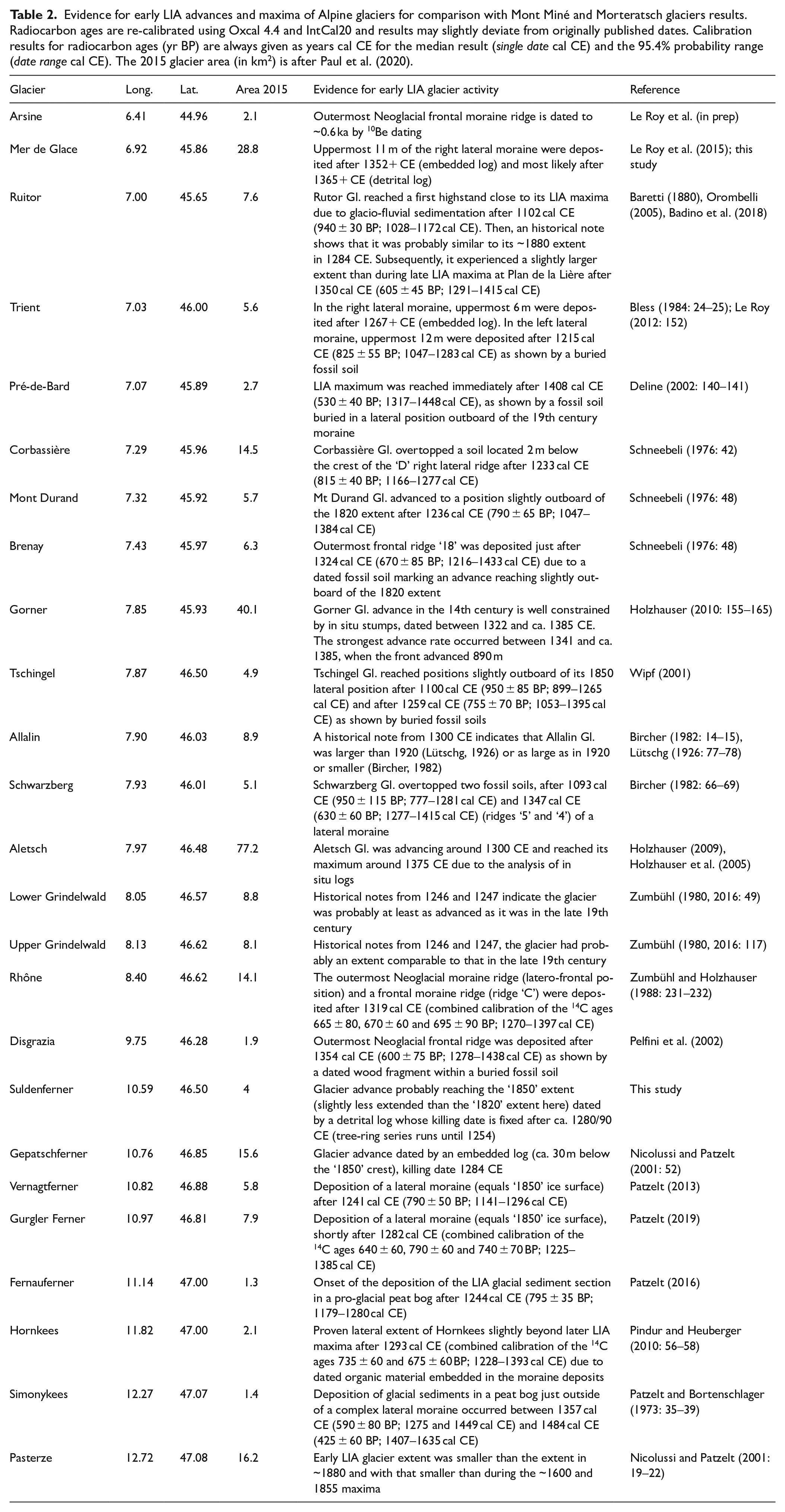
Evidence for early LIA advances and maxima of Alpine glaciers for comparison with Mont Miné and Morteratsch glaciers results. Radiocarbon ages are re-calibrated using Oxcal 4.4 and IntCal20 and results may slightly deviate from originally published dates. Calibration results for radiocarbon ages (yr BP) are always given as years cal CE for the median result (single date cal CE) and the 95.4% probability range (date range cal CE). The 2015 glacier area (in km2) is after Paul et al. (2020).
A lack of distinct evidence for extensive advances of MOR during the early ninth century and the HMAP also puts into question previous interpretations of a local pre-LIA glacier maximum that should have slightly exceeded the c. 1860 CE glacier length (Fitze, 1980, 1982). According to the radiocarbon date of a fossil soil (2 σ: 773–994 cal CE; Supplemental Table S3) located between two terminal moraine deposits, this maximum of MOR would have occurred around or somewhat after 900 CE. Yet, this interpretation of a glacier maximum based on the soil dating is in conflict with the lifetime of the dated samples from MOR (Figure 4). It is more likely that the 14C date of the soil, probably due to soil material of different age (Fitze, 1980: 98), has become too old relative to the moraine deposition and only gives a maximum age for this moraine. We would rather suggest that this terminal moraine, located slightly downvalley of the c. 1860 CE moraine, would have been deposited during a maximum of MOR towards the end of the early LIA phase or, as also discussed by Fitze (1980: 98), at the beginning of the main LIA phase.
Evidence for the early LIA advance phase at other Alpine glaciers
The early LIA glacier advance at MM and MOR in the decades around 1300 CE and the subsequent maximum coincides with findings available for other glaciers in the Alps (Figure 6, Table 2). By way of example, in the case of the Rhone Glacier, Swiss Alps, a maximum exceeding later LIA maxima in length has been indicated by means of 14C dates of overburdened soils below a terminal moraine (Zumbühl and Holzhauser, 1988). The mean and subsequently calibrated result of several 14C ages dates the moraine deposition to slightly after 1319 cal CE (Table 2). Likewise, averaging and calibrating several radiocarbon dates from organic material sampled under a lateral moraine ridge of the Gurglerferner, Austrian Alps (Patzelt, 2019), dates the moraine deposition and with that the glacier maximum, to after 1282 cal CE (Table 2). Similarly, buried and 14C-dated soil material under a lateral moraine of the Vernagtferner, Austrian Alps, demonstrates a maximum of this glacier after 1241 cal CE (Patzelt, 2013; Table 2). Further evidence for this early LIA phase in the Alps exists, mostly based on radiocarbon dating of buried soil layers, thus yielding dates with lower accuracy and more uncertainty regarding related glacier activity (Table 2).
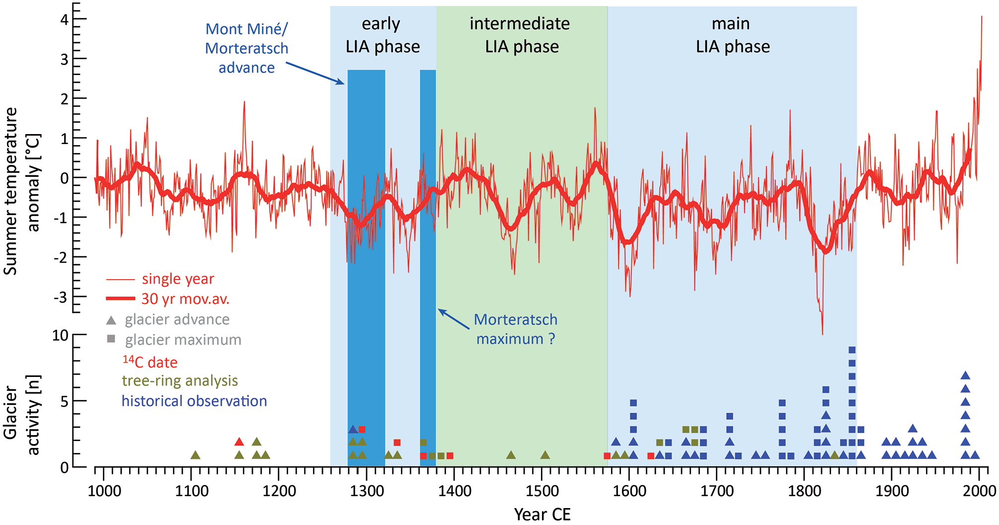
Glacier advances, maxima and summer (June-August) temperature variability in the Alps during the last millennium. The tree-ring based climate reconstruction (Büntgen et al., 2011) indicates distinct lower summer temperatures (indicated as deviations from the 20th century mean) in the late 1200s and in the 1300s corresponding to the highlighted glacier advances at Mont Miné and Morteratsch glaciers. Moreover, the temperature record, together with advance and maxima dates of selected glaciers (Supplemental Table S4), allows the subdivision of the LIA in the Alps into an early (c. 1260–1380 CE), intermediate (c. 1380–1575 CE) and main phase (c. 1575–1860 CE).
Dendrochronological analysis of the tree stumps and tree remnants found at MM and MOR can help to considerably improve dating accuracy. Similar to the sites presented in this study, there is evidence for an advance in the late 13th century burying trees in 1296 CE at Mer de Glace, French Alps. The maximum can be dated to shortly after 1352 CE, and most probably around 1370 CE, according to the analysis and dating of embedded and detrital logs from the right lateral moraine (Le Roy et al., 2015). At Gorner Glacier, Swiss Alps, an advance phase is demonstrated for around 1327 CE on the basis of the dating of in situ logs (Holzhauser, 2010; Holzhauser et al., 2005). The maximum was reached c. 1385 CE during which a tree died and was preserved in a lateral moraine just outside of later deposited LIA moraines. The Aletsch Glacier, Swiss Alps, advanced around 1300 CE and reached an extent comparable to that of c. 1930 CE at that time (Holzhauser, 1984). Maximum was reached shortly after 1369 CE, probably around 1375 CE (Holzhauser, 2009). At this point, the glacier expanded (at least in the area of the lateral moraines) to an extent corresponding to the LIA maximum levels (Holzhauser, 2009). For the Suldenferner, Italian Alps, an advance after 1254 CE can be deduced from the dating of a detrital log (Nicolussi, unpubl.). Considering the missing sapwood of the European larch remnant, the advance may have taken place in the 1280/90s to reach glacier dimensions that were close to those recorded in the mid-19th century. At Gepatschferner, Austrian Alps, the advancing glacier killed a tree in 1284 CE and embedded it into a lateral moraine (Nicolussi and Patzelt, 2001). Similarly, at Lower Grindelwald Glacier, Swiss Alps, an advance is proven for 1338 CE by the death date of a likewise relocated log (Holzhauser, 2016). However, an accurate date for the end of the advance is missing at Lower Grindelwald glacier as at Mont Miné, Suldenferner and Gepatschferner glaciers.
In contrast to the main LIA phase (c. 1575–1860 CE), historical documents mentioning glaciers are largely lacking before 1500 CE. This is explained by the lack of cartographic documentation and the overall low number of written and pictorial environmental observations, however, with this in mind we present two examples of historical documentation from the 1200s onwards. At the Rutor glacier, Italian Alps, a notice reports an outburst of a lake which was probably dammed by the advanced glacier in 1284 CE (Baretti, 1880). Similar events are repeatedly reported from the late 16th century until 1864 when the advancing Rutor glacier established an ice dam causing lake highstands, followed by outburst floods (Badino et al., 2018; Baretti, 1880). The early LIA phase at Rutor glacier is probably also indicated by a fossil soil buried by a frontal moraine immediately outboard the late-LIA maximum positions, and dated to c. 1350 cal CE (Orombelli, 2005; Table 2). The Lower and Upper Grindelwald glaciers are mentioned in two documents from 1246 to 1247 CE, from which comparatively large extents of these glaciers can be assumed (Zumbühl, 1980, 2016; Zumbühl et al., 1983). Such evidence for probably generally advanced glacier positions in the 1240s may also explain that the cooling from the 1260s onwards was soon followed by a striking advance in the 1280s, which can be demonstrated both at the MM and the MOR.
Noteworthy, although with some exceptions (Table 2), maxima during the 14th century that would have reached or even slightly exceeded the extent of later LIA maxima can often be found in lateral moraines and far away from terminal moraine positions. This suggests that although ice thicknesses achieved in the early LIA phase could have been comparable to those of later LIA maxima, glacier lengths might have remained somewhat shorter in many cases. This can be demonstrated for the Pasterze glacier, where a tree killed and buried in 1591 CE by the advancing glacier tongue during the onset of the main LIA phase had already started to grow shortly before 1268 CE and was not reached by the glacier during the 13th/14th century advance phase (Nicolussi and Patzelt, 2001; Table 2).
Subdivision of the Little Ice Age in the Alps
Glaciers in the Alps are in general mainly sensitive to the variability of summer temperatures and associated conditions (sunshine duration, precipitation type) and less to winter season conditions (e.g. Parkes and Goosse, 2020; Zemp et al., 2015). The advances of MM and MOR at the onset of the LIA also coincides with a strong and simultaneous, multi-decadal cooling in the Alpine region as evidenced by a tree-ring based summer temperature reconstruction (Büntgen et al., 2011). Pronounced cooling starting c. 1260/70 may have been favoured by a cluster of large tropical volcanic eruptions (1230, 1257, 1276 and 1286 CE) causing substantial cooling across the northern hemisphere (Stoffel et al., 2015), especially in the aftermath of the massive eruption of Mount Samalas in Indonesia in 1257 CE and the subsequent ‘year without a summer’ in 1258 CE (Guillet et al., 2017). Moreover, the late 1200s and first half of the 1300s was characterised by reduced solar activity as recently shown by yearly resolved radiocarbon measurements (Brehm et al., 2021). According to the climate reconstruction (Büntgen et al., 2011), the pronounced cooling lasted until around 1310 CE and was followed by a few decades with higher temperatures, before another distinctly cool phase occurred approx. 1340/60 (Figure 6). For comparison, reconstructed summer temperatures during the early LIA phase (c. 1260–1380) were on average about 0.73°C below the 20th century mean.
From about 1380 to c. 1450 CE, cool periods are absent and temperatures remained at a comparably higher level. With the warming at the end of the 1300s, the early LIA phase also comes to an end and a retreat can be demonstrated, for example for Aletsch glacier (Holzhauser, 2010). That is, the Aletsch glacier was smaller from at least c. 1455 to 1588 CE than it was around 1920 (Holzhauser, 1984). Simulation results realised with a numerical glacier model, forced by different climate scenarios, confirm a reduced glacier extent in the Alps for the 15th/16th century compared to the early as well as the main LIA phase (Parkes and Goosse, 2020), even if results strongly scatter between different runs. From the mid-15th century onwards, scarce evidence exists for advances of Alpine glaciers (e.g. Aletsch and Gepatschferner glaciers; Holzhauser, 1984, 2010; Nicolussi and Patzelt, 2001). However, no proofs hitherto exist for glacier maxima until the main LIA phase (Figure 6). Historical observations of the Lower Grindelwald Glacier and the Mer de Glace from 1530/1570 document that their glacier termini were in advanced positions, but c. 300 and 1200 m, respectively, behind later LIA maxima (Nussbaumer et al., 2007; Zumbühl et al., 1983). During this intermediate LIA phase, lasting from c. 1380 to 1575, summer temperatures (Büntgen et al., 2011) were on average higher than during the early LIA but still −0.24°C below the 20th century mean.
By contrast, for several Alpine glaciers the variability during the last and main, that is the longest and often most intensive phase of the LIA, lasting from c. 1575 to 1860, is exceptionally well documented through observations, drawings, maps and measurements of that period (e.g. Nicolussi, 1993, 2013; Nussbaumer and Zumbühl, 2012; Nussbaumer et al., 2007; Zumbühl, 1980). During this period, mean summer temperatures (Büntgen et al., 2011) were −0.82°C below the 20th century mean, and thus only slightly cooler compared to values reconstructed for the early LIA phase (with −0.73°C). Nonetheless, most Alpine glaciers reached their largest LIA maximum during this main phase of the LIA (Grove, 2004).
The first book on glaciers in the Austrian Alps, called ‘Nachrichten von den Eisbergen in Tyrol’ (roughly: News from the glaciers in Tyrol), was written by Walcher (1773) in the context of the 1770s advance of the Vernagtferner. Walcher mentions local histories that claim the glaciers had only been established in the 13th century. This statement, although lacking any reference, fits impressively well with the reconstructed advance of MM and MOR at the onset of the LIA in the late 13th century.
Conclusions
At Mont Miné (MM) and Morteratsch (MOR) glaciers, located in the Western and Eastern Swiss Alps, a glacier advance spanning the period 1280s to the 1310s can be demonstrated by detailed analysis of remnant European larch and Cembran pine trees buried within moraine sediments. Samples of in situ and embedded tree remnants show that forest stands at least 400 years in age were destroyed during this advance phase at both glaciers. At MOR glacier, the maximum of this advance phase at the onset of the Little Ice Age occurred probably around 1375 CE, as inferred from a detrital log, whereas for MM glacier, the maximum cannot be dated precisely. MOR glacier reached and overtopped a pre-LIA lateral moraine around 1300 CE; the distal surface of the latter is 12–13 m below the present lateral moraine crest. At MM glacier, the ice surface of the early LIA advance culminated at least 16 m below the level of the later LIA moraine crest.
At MM and MOR, logs from the 500s were also dendrochronologically dated. These logs are most likely associated with the sixth century advance phase documented at other Alpine glaciers. As these logs are detrital samples, the extent and maximum of this glacier advance at MM and MOR remain unclear.
The glacier advance at the end of the 1200s at MM and MOR coincides with a significant temperature decline in the Alps lasting for several decades, the onset of which appears to be around 1260/70 CE. The positive glacier mass balances derived from this cooling led to the glacier advance that we can now document precisely. The relatively short delay of the glacier advance after the onset of the cooling, as shown for MM and MOR, but also visible at other Alpine glaciers, suggests that the glaciers were already relatively extensive before the 1260s.
Based on the evidence on past variability of MM and MOR as well as other Alpine glaciers, and taking into account climatic conditions during the last millennium, it can be demonstrated that the Little Ice Age was not a uniform period, but had several phases. After a first phase of glacier advances and maxima, also characterised by low mean temperatures from the late 1200s to the late 1300s, the following two centuries witnessed less extensive glaciers and somewhat higher mean temperatures, before a series of glacier maxima, again associated with low mean temperatures, followed from the late 1500s to the mid 1800s. Based on these results, we propose a subdivision of the Little Ice Age in the European Alps (which we define here as spanning approximately the period 1260–1860 CE) into an early (c. 1260–1380 CE), intermediate (c. 1380–1575 CE) and main phase (c. 1575–1860 CE).
Supplemental Material
sj-pdf-1-hol-10.1177_09596836221088247 – Supplemental material for The glacier advance at the onset of the Little Ice Age in the Alps: New evidence from Mont Miné and Morteratsch glaciers
Supplemental material, sj-pdf-1-hol-10.1177_09596836221088247 for The glacier advance at the onset of the Little Ice Age in the Alps: New evidence from Mont Miné and Morteratsch glaciers by Kurt Nicolussi, Melaine Le Roy, Christian Schlüchter, Markus Stoffel and Lukas Wacker in The Holocene
Footnotes
Acknowledgements
We are grateful to Gian Andri Godly, Andreas Österreicher, Thomas Pichler and Georg Weber for sampling and field assistance and/or precise tree-ring measurements. We are indebted to Jean-Louis Edouard for pointing us the archival F. Röthlisberger’s samples. We warmly thank Rémi Fontaine who introduced us to old unpublished photographs of Morteratsch glacier. We would like to thank Ann Rowan, Joshua Leigh and an anonymous reviewer for valuable comments and suggestions.
Funding
The author(s) disclosed receipt of the following financial support for the research, authorship, and/or publication of this article: This research was supported by the Austrian Science Fund (FWF, grant I-1183-N19) and by the Swiss National Science Foundation (SNF: Spark project MNEMOSYNE (SNF no 183571) and Sinergia project CALDERA (SNF no 190134)).
Supplemental material
Supplemental material for this article is available online.
References
Supplementary Material
Please find the following supplemental material available below.
For Open Access articles published under a Creative Commons License, all supplemental material carries the same license as the article it is associated with.
For non-Open Access articles published, all supplemental material carries a non-exclusive license, and permission requests for re-use of supplemental material or any part of supplemental material shall be sent directly to the copyright owner as specified in the copyright notice associated with the article.