
Abstract
Charcoal from archaeological contexts differs from off-site pollen samples as it is mainly a product of intentional human action. As such, analysis of charcoal from excavations is a valuable addition to studies of past vegetation and the interaction between humans and the environment. In this paper, we use a dataset consisting of 6186 dated tree species samples from 1239 archaeological sites as a proxy to explore parts of the Holocene forest development and human-vegetation dynamics in South-Eastern Norway. From the middle of the Late Neolithic (from c. 2000 BC) throughout the Early Iron Age (to c. AD 550) the region’s agriculture is characterized by fields, pastures and fallow. Based on our data, we argue that these practices, combined with forest management, clearly altered the natural distribution of trees and favoured some species of broadleaved trees. The past distribution of hazel (Corylus avellana) is an example of human impact on the vegetation. Today, hazel is not even among the 15 most common tree species, while it is one of the most prevalent species in the archaeological record before AD 550. The data indicate that this species was favoured already by the region’s Mesolithic hunter-fisher-gatherers, and that it was among the species that thrived extremely well in the early farming landscape. Secondly, our analysis also indicates that spruce (Picea abies) first formed large stands in the south-eastern parts of Norway c. 500 BC, centuries earlier than previously assumed. It is argued that this event, and a further westward expansion of spruce, was partly a consequence of a specific historical event – the first millennium BC farming expansion.
Keywords
Introduction
The relationship between past vegetation and human activity can be studied by applying different methods and approaches. Pollen analysis with associated proxies (microscopic charcoal, fungal spores, etc.) has been highly valuable in reconstructing Holocene landscape and vegetation development as well as informing how humans have interacted with the environment. Even though pollen analysis is the main method for reconstructing temporal vegetation changes, offering information on a wide range of plant taxa, it involves some uncertainties to rely on pollen data to reconstruct past vegetation (Mehl and Hjelle, 2016). The total number of high-quality pollen diagrams can also be limited in certain regions, which is the case for South-Eastern (SE) Norway, the region under study (cf. Figure 1).
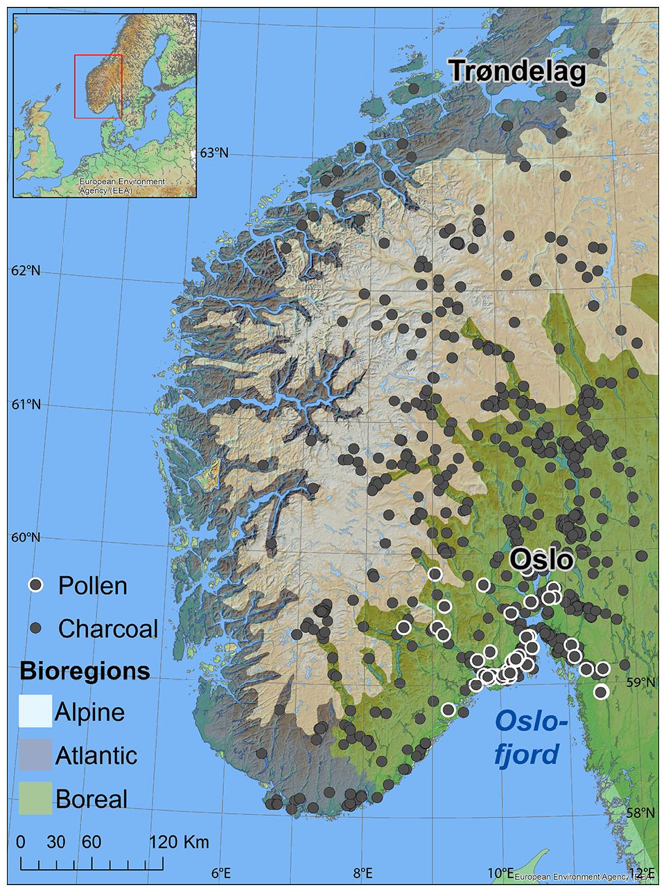
Archaeological sites (n = 1239) with dated tree species samples (n = 6186) and pollen records (n = 59) that are included in the study. The map also shows biogeographical regions as defined by the European Environment Agency and the Norwegian Directorate for Nature Management (2007).
In this paper we turn our attention to a hitherto under-utilized source of knowledge for studying human-vegetation dynamics in Norway, namely charcoal and wood from archaeological excavations. In contrast to the more restricted number of pollen analyses, archaeologists sample a nearly uncountable number of macroscopic plant remains from a great number of contexts of anthropogenic origin each year. Even if single contexts with macrofossils provide limited information about past vegetation, their accumulated temporal and spatial distribution makes them useful for the study of human-environment interaction. Thus, we will utilize dated samples of charcoal and wood from archaeological contexts and make this record relevant in studies of Holocene forest development to gain information on the presence of wood taxa and especially on human-vegetation dynamics.
Anthracological studies have shown how analysed charcoal samples from archaeological contexts can provide a high-resolution picture of past vegetation and valuable data on human-vegetation dynamics (e.g. Asouti and Austin, 2005; Chabal and Heinz, 2021; Kabukcu and Chabal, 2021). Yet charcoal samples from archaeological contexts are mainly used for radiocarbon dating, and normally the dates themselves form the basis of research, while detailed information on tree species often remains an unutilized source of information (but see Bartholin and Mikkelsen, 2012; Damm, 2022). Human impact on forest development in SE Norway has mainly been discussed based on pollen data (see Høeg et al., 2018; Wieckowska-Lüth et al., 2017).
Using charcoal from archaeological contexts as a source to study vegetation change has some challenges as a result of choices made by humans in the past (e.g. cultural behaviour), post-depositional processes (e.g. fragmentation, size of sample) and research-based decisions (e.g. species determination, and which species are chosen for dating). Still, as charcoal from such contexts is a product of both ecological processes and human behaviour, we suggest that this can be used to infer information on environmental conditions and human activities. To support this claim, we adhere to arguments of a close connection between wood selection and woodland composition in the landscape near a given site (Asouti and Austin, 2005: 2; Kabukcu and Chabal, 2021: 14). Thus, we argue that roughly 6000 dated charcoal samples from more than 1200 archaeological sites will add significant knowledge to the interpretation of the past vegetation of the region and the role humans played in the use and development of the forest during the Holocene. Based on charcoal from archaeological contexts, we aim to investigate the development in human-vegetation dynamics in South-Eastern Norway, by focussing especially on the direct impact of large-scale developments in farming for the expansion of species and forest composition during the Late-Holocene (~2300 BC–AD 550). 1
Geography and climate
South-Eastern Norway has a total area of 104,000 km2 (Statistics Norway, 2013) and extends between approximately 58° and 62°N (Figure 1). The distance from the northern to the southern point is approximately 540 km, and the east-west distance is more than 300 km. The topography is varied, with a large coastal region, low-lying inland areas and alpine regions with altitudes of approximately 1000–2500 m above present sea level. The coastal areas have a moist climate with mild winters, while much of the inland is in a rain shadow with limited precipitation and a larger variety between summer and winter temperatures. The bedrock in the region shows a large variance; combined with a varied topography and human impact, this increases the region’s local and regional vegetation (Moen, 1999: 11; cf. Puschmann, 2005). The region is commonly divided into five to eight climatic regions, spanning from a nemoral zone with a broad deciduous woodland along the southernmost coast to treeless alpine zones above 1000–1200 m over present sea level. In between are nemoboreal, southern boreal, middle boreal and northern boreal belts (Moen, 1999).
All species in our record can be found in coastal areas, including thermophilous species like ash (Fraxinus), oak (Quercus) and European yew (Taxus baccata) (Moen, 1999). More cold-tolerant deciduous trees, such as hazel (Corylus), alder (Alnus) and wych elm (Ulmus glabra) grow further inland. Boreal vegetation zones are mostly limited to the interior, and the present-day forests here consist for the most part of coniferous woodland and birch (Betula spp.), but also of some other cold-tolerant deciduous trees (e.g. aspen (Populus tremula), willow (Salix spp.), rowan (Sorbus aucuparia). Climate changes have undoubtedly affected the delimitations of these regions’ vegetation zones through time (e.g. Hallang et al., 2022). However, in general the variation in summer temperature has been well below 1°C during the period of main interest (c. 2300 BC–AD 550, Sejrup et al., 2016) and the climatic zones applied here have been relatively stable, when viewed in a regional perspective (cf. Høeg et al., 2018).
Today 5.2% of SE Norway is cultivated (Statistics Norway, 2019) and arable land is an important element in landscapes up to the lower part of the middle boreal zone (Moen, 1999: 107), the same areas that are more broadly defined as the atlantic and boreal biogeographical regions (Directorate for Nature Management, 2007: 10–11, cf. Figure 1). Archaeological excavations have shown that the prehistoric farms were located in the most favourable parts of the atlantic and boreal regions (Gjerpe, 2017).
Of the roughly 6000 dates included in this study, 201 are from archaeological contexts in regions neighbouring South-Eastern Norway.
Present knowledge of Holocene vegetation history
Early research on long-term vegetation and paleoclimate changes in Scandinavia was reliant on macrofossils (e.g. charcoal, needles and seeds) and mega fossils (e.g. branches and tree stumps) (Birks and Seppä, 2010: 655–656). However, methodological advances in the middle of the 20th century made pollen analyses better and more reliable, with the consequent declining interest in the use of large plant remains in vegetation studies. As a result, present-day palaeoecological reconstructions are mainly based on pollen data, from single sites and from compiled datasets containing many pollen diagrams, even if interpretations are partly supported by finds of macroscopic plant remains (e.g. Bjune et al., 2013; Kullman, 2008; Moe, 1979; Ohlson et al., 2017), ancient DNA (e.g. Capo et al., 2021; Parducci et al., 2017) and DNA from present-day vegetation (e.g. Myking et al., 2011; Tollefsrud et al., 2015).
An issue with parts of the pollen record from Norway is that it was collected decades ago, with suboptimal equipment (Hiller corer). The records were dated by a low number of radiocarbon dates with large standard deviations and occasionally collected as bulk samples from layers (e.g. Høeg et al., 2018). Thus, the temporal precision can be low and cause uncertainties in interpretations of a pollen record.
The quantity of pollen produced by different tree species varies also significantly (Broström et al., 2008; Sugita, 2007a, 2007b). Many of the wind-pollinated species produce large amounts of pollen grains (e.g. pine (Pinus), spruce (Picea), birch, alder (Alnus) and oak (Quercus)) with potential for a vast distribution. In contrast, insect-pollinated trees (e.g. cherry (Prunus spp.), maple (Acer) and willow (Salix)) produce much less pollen and have a lower distribution range, resulting in wind-pollinated species being overrepresented in pollen records. In addition, wind transport can sometimes make it difficult to decide whether small amounts of pollen originate from a few nearby specimens, or from a larger, distant population (Birks, 2003; Giesecke, 2013: 855). In general, it is methodologically problematic to use palynological data to gain information on species with low population densities in a vegetation generally dominated by other taxa (Bennett, 1985), especially in cases where species spread to new areas in low populations, or exist in small refuges (Giesecke, 2013: 859; cf. Kullman, 2008).
Despite these shortcomings, the data still provide an overview of the trends in forest dynamics and landscape development during the Holocene, and more recent methodological developments, such as modelling of estimated regional vegetation cover, have been valuable in overcoming the local signature of single pollen records as well as the limited numbers and geographical distribution of pollen records (e.g. Mehl and Hjelle, 2015; Sugita, 2007a, 2007b).
The ice sheet retreated from the Ra moraine at the outer coast of Scandinavia approximately 11,600 years ago, near the start of the Holocene, while the main parts of the interior regions were deglaciated before the end of the Preboreal phase (c. 8200 BC, Mangerud et al., 2018; Romundset et al., 2018, 2019). The deglaciation, combined with rising temperatures, opened for a northward and eastward spread of flora and fauna that could adapt to the warmer climate of the phase. Based on multiple pollen core analyses (Giesecke et al., 2017; Høeg et al., 2018, 2019; Mangerud et al., 2018) it is suggested that species like birch, aspen (Populus tremula), elm (Ulmus glabra) and oak (Quercus robur) became established as a part of the SE Norwegian flora before 9000 BC. At the transition to the Boreal phase (c. 8200 BC) hazel (Corylus avellana), and Scots pine (Pinus sylvestris) also appeared, while alder (Alnus spp., c. 7200 BC) and lime (Tilia cordata, c. 5650 BC) expanded to the region somewhat later. Pollen data suggest that spruce (Picea abies) became common in parts of SE Norway c. AD 1, but this does not exclude the possibility of earlier outposts (Bjune et al., 2009; Giesecke and Bennett, 2004; Høeg et al., 2019; Tollefsrud et al., 2015, see also discussion below). Pollen analysis shows that beech (Fagus sylvatica) was introduced, or at least became much more common, in coastal parts of Vestfold between AD 700 and 900 (Bjune et al., 2013; Myking et al., 2011), as the last of the large and relatively common tree species to expand in the region.
Data and methods
Our data consist of 6186 dated charcoal and wood samples identified to tree species from 1239 archaeologically excavated or surveyed sites distributed throughout the vegetation zones in SE Norway, see Table 1, Figure 1 and Supplemental Table 1. Coordinates and corresponding biogeographical regions for all samples are included in the Supplemental material. The database contains different materials but charcoal from a range of tree species makes up the majority of the data, approximately 92%. The database also includes samples of unburned wood (4.6%), bark and bast as well as hazelnut shells (2.1%) and other macrofossils (Table 1). The dated charcoal and wood samples are remains of wood used for different implements and tasks such as firewood, buildings and iron production.
The table presents a summary of the data included in the analysis divided into the three biogeographical regions.
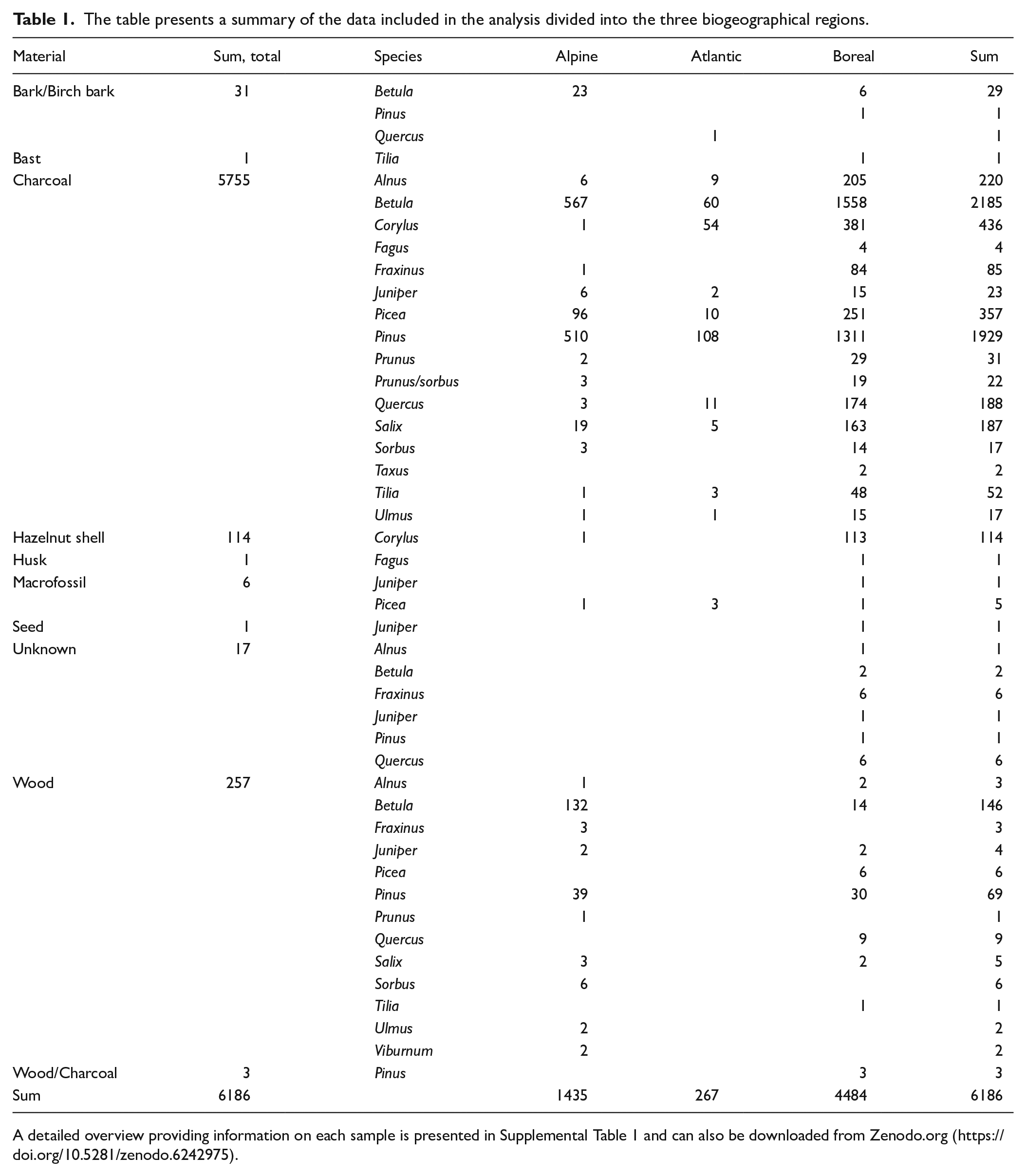
A detailed overview providing information on each sample is presented in Supplemental Table 1 and can also be downloaded from Zenodo.org (https://doi.org/10.5281/zenodo.6242975).
The samples were collected from a variety of features related to human activity from different site contexts. Most samples originate from settlements and activity areas in present and former agricultural areas and from production sites for iron and charcoal that are mostly situated in forested, often elevated inland areas. Both the natural and the cultural context where the samples are collected may affect the proportion of different tree species. Thus, we have divided the data into three overall categories: ‘Settlement sites’, ‘Iron production sites’ and ‘Other’, see Supplemental Table 1. The category ‘Other’ is the largest and includes contexts such as cooking pits, burials, cairns, different anthropogenic layers and wooden artefacts. Using the three overall contexts offers a useful indication of the variety and relative amount of tree species collected from different contexts and landscapes. To exemplify from iron production sites, pine, birch and spruce, make up 96.5% of the samples. This is related to the location of the majority of iron production sites in forests and moorlands in the central part of the study area (Larsen, 2009).
An ambition of this paper is to explore how early farming societies affected the region’s forest dynamics. We consider the records from the SE Norwegian boreal biogeographical region to be best suited for this approach, as this was an important area for prehistoric farming and the region within SE Norway where early farming is studied in greatest detail (e.g. Gjerpe, 2017). In addition, this is the most densely mapped part of our record in terms of archaeological contexts (see Figure 1, Table 1). Concerning farming vegetation dynamics, we have omitted charred hazelnut shells found in the bioregion (n = 113) from our analysis, since they commonly preserve better than charcoal and therefore potentially could cause a bias in the analysis (cf. Bishop, 2019). Additionally, we exclude the iron production sites from this part of our analysis (n = 1028), since iron production commonly took place in the outfields and thus offers limited information on how the farming activity influenced nearby vegetation.
No new species identifications have been performed for the present study, and we rely on identifications carried out as part of the post-excavation work in projects at the Museum of Cultural History (MCH). In order to determine the species of the sampled charcoal, MCH cooperates with archaeobotanists at Moesgaard Museum, and charcoal samples from archaeological contexts are routinely sent to anthracologists for species identification. The number of fragments identified to species in each samples varies but regularly at least 10 fragments are identified, and sometimes more (Bartholin and Mikkelsen, 2012). Reports from the archaeological excavations, including reports from anthracological analysis, are available in the archive at MCH and reports written after 2001 are available in an online repository. 2
The charcoal is primarily collected to date archaeological structures, and the charcoal included here is not sampled according to the strict principles put forward by Kabukcu and Chabal (2021). Still, we argue that the data are robust enough to give valuable information on the presence of different species as well as on human utilization of woodland on a larger spatial and temporal scale. Our accumulated data are temporally and spatially distributed within SE Norway, collected from different short- and long-term events, coming from both domestic and non-domestic activities (day-to-day and longer intervals), and contain sufficient quantities to allow meaningful analysis at this level (cf. Asouti and Austin, 2005: 5). We also stress that we consider the data to represent proxies from which we can infer changes in human-vegetation dynamics and not that the proportional values of different species in our data are similar to past vegetation.
In order to radiocarbon-date archaeological structures with as high precision as possible, it is preferable to use the charred material with the estimated youngest own-age. Consequently, tree species that rarely grow very old (e.g. birch and hazel) are favoured for dating compared to trees that have a longer lifespan (e.g. oak and pine, Hambro Mikkelsen, 2020; Loftsgarden et al., 2013). However, a charcoal sample from an archaeological structure can often include several tree species. In our dataset, 4945 charcoal samples are identified to a single species, while the remaining 555 charcoal samples include two or more species. Regarding charcoal samples containing two or more tree species, only one tree species is used for dating, and usually the species with the lowest own-age. Consequently, there are 5500 dated charcoal samples. Nevertheless, we have included all species from each charcoal sample in our database. Since we regard the age of the dated species to be sufficiently representative of the age of the remaining species, as pertaining to the research questions raised in this paper, the total number of identified tree species samples in our data is accordingly 6186.
In order to visualize the temporal distribution of the samples in the dataset we provide a summed probability plot (SPD) in Figure 2, including a running mean of 100 years of all radiocarbon dated samples. The SPD is made using the Rcarbon package (Crema and Bevan, 2021) developed for R programming language (R Team, 2020). To explore the relative proportions of dated samples in the dataset we visually compare SPDs of different sampled species using the stackSPD function in Rcarbon, see Figure 5. All dates are calibrated using the IntCal 20 calibration curve (Reimer et al., 2020).
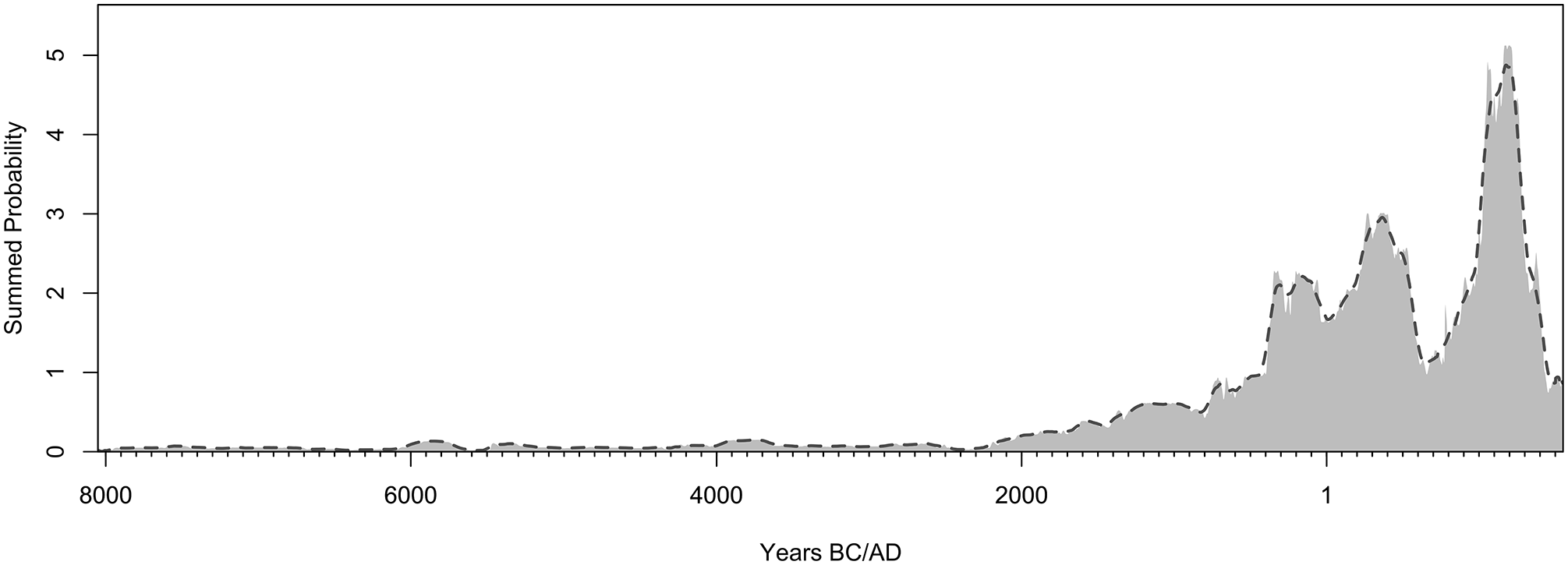
Sum probability plot of radiocarbon dates included in the study (n = 5500). The data were analysed using the Rcarbon package (Crema and Bevan, 2021) developed for R programming language (R Team, 2020). The dates are calibrated using the IntCal 20 calibration curve (Reimer et al., 2020).
To produce the distribution map in Figure 6 showing the gradual spread of spruce in Southern Norway, we use the mean date of single spruce samples calibrated in OxCal 4.4 plotted and visualized using ArcGis version 10.8 and Adobe Illustrator.
Results and discussion
The sources of the charcoal samples
The samples are chronologically distributed between c. 8000 BC and AD 1800 and most of them come from archaeological contexts consisting of remnants of firewood and burned structural remains. Different models of explanation for wood selection have been put forward (Asouti and Austin, 2005; Bishop et al., 2015; Delhon, 2021), and although there are differences between tree species in their suitability as fuel, the most important criterion seems to have been availability and proximity to habitation site, descriptively named ‘The Principle of Least Effort’ (Théry-Parisot et al., 2010, with further references; Asouti and Austin, 2005; but see Delhon, 2021). In the Middle and Late-Holocene, wood was an easily accessible resource in major parts of SE Norway, except in some outer coastal regions and in higher alpine areas (Hjelle et al., 2010; Selsing, 2010). The accessibility of wood probably also limited the need for long-distance transport of fuel, at least until towns were established at the transition to the Middle Ages (cf. Post-Melbye and Rundberget, 2020). Some wooden artefacts, such as boats, tool handles, bows and arrows, were treasured objects and could potentially be transported over long distances (e.g. Bonde and Stylegar, 2016). A selection of such artefacts would be reduced to charcoal, for example as part of cremation pyres. As such, it is crucial to have an overview of the proportion of charcoal from artefacts.
In that regard, we can use the frequency of European yew as an example (Høeg, 1974: 631–632). Yew is a coniferous tree known for its durability and used for the production of multiple artefacts, ranging from archery bows to sledge runners and fence posts (Høeg, 1974: 631–632). In present-day Norway the species is widely distributed along the coast, but relatively uncommon (Moen, 1999; Red List, 2015: 72). This seems also to be reflected in our database as it contains only two samples of charcoal of yew (B-110239, 2100 ± 40 BP, Ua-46718, 1132 ± 30 BP). Despite the low number of charcoal samples of yew from settlement sites, there are 27 Iron Age (c. 500 BC–AD 1030) artefacts made of the species in Norwegian archaeological museums, 3 including the so-called ‘Buddha bucket’ from the Oseberg Viking ship burial (see Figure 3, Brøgger et al., 1917; Hagen, 1959). Although this is of Anglo-Saxon or Celtic origin, the 27 different artefacts of yew show that this species was widely used for woodwork in Scandinavia at least from the Early Iron Age. Yet the species is hardly represented at all in the dated charcoal samples, indicating that an insignificant part of the charcoal included in this study are likely to be remains of portable artefacts.
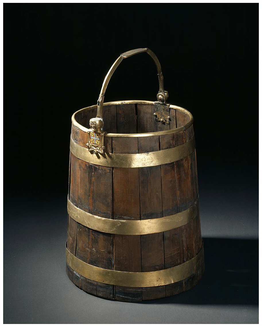
The ‘Buddha bucket’ made of European yew, from the Oseberg ship burial. Photo: Johnsen, Eirik Irgens © 2020 Kulturhistorisk museum, UiO/CC BY-SA 4.0.
Wooden artefacts would have been included in cremation burials. However, the temperatures required for a cremation pyre mean that large amounts of firewood are needed, further adding to the assumption that artefacts will commonly constitute a negligible part of the total amount of preserved charcoal remains (cf. Yermán et al., 2018). In addition, studies on the choice of wood in cremation pyres suggest that there was not a preferred tree species used for cremation ceremonies; the selection was based on availability and quality as fuel (Deforce and Haneca, 2012; Moskal-del Hoyo, 2012).
Altogether, we find it unlikely that the transport and later burning of different wood species have any significant effect on our conclusions, especially also since the study focuses on the distribution of species on a supralocal scale.
Long-term forest dynamics in SE Norway
Fifteen different tree species are represented in the database, numbering between one and more than 2000 dated samples. The distribution of several of these tree species in our data deviates from the proportional distribution of tree species in present-day SE Norway, although today’s most common species (spruce, pine, and birch) also appear most frequently in the archaeological dataset. The two largest differences are a general underrepresentation of spruce and overrepresentation of hazel in the archaeological record (Figure 4).
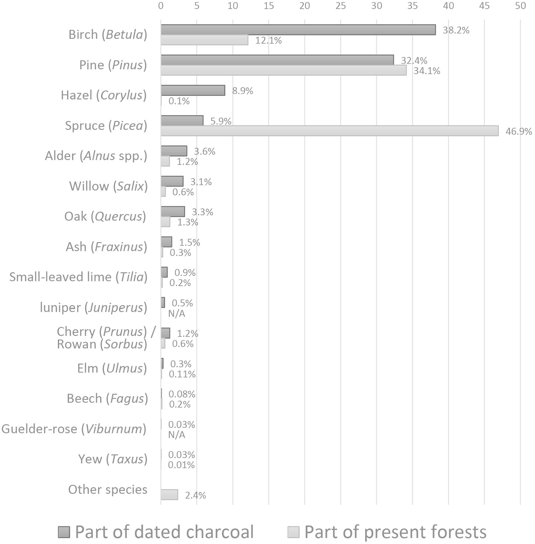
Tree species samples included in the study (n = 6186) and the most common tree species in present-day SE Norway (based on data from Breidenbach, 2016).
When looking at the proportional temporal distribution of most common species in the boreal biogeographical region we can see variation across time (Figure 5). Pine dominates the dataset until c. 2000 BC. There is a marked decrease in birch from 2900 to 2300 BC, although the number of samples before 2000 BC is low (n = 199, Figure 2). Around 2100 BC hazel increases – peaking at c. 1000 BC. Despite a slight decrease, the proportion of hazel remains relatively stable until about AD 550. The proportional distribution of birch and alder is quite stable between c. 2000 BC and AD 550, when pine, as well as spruce, increase, at the expense of oak, willow and to some degree birch.
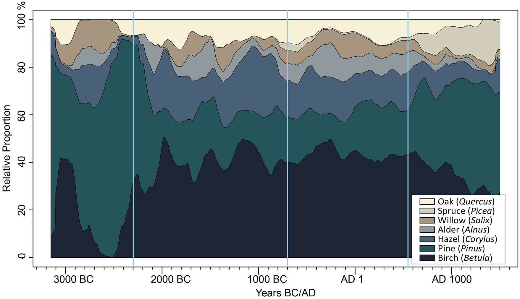
A visual representation of the proportional temporal distribution of the seven most common tree species (3150 dated samples) from the boreal biogeographical region, using the stackCalSPD function of Rcarbon (Crema and Bevan, 2021). Hazelnut shells and samples from iron production sites are not included. Ill. K. Loftsgarden and A. Mjærum, MCH.
This opens for a range of discussions of the region’s vegetation history. We will use the much-debated Late-Holocene expansion of spruce as an example of what radiocarbon data can offer to studies of vegetation development, see Figure 6. Still, the expansion of spruce or other significant Late-Holocene forest developments cannot be well understood without taking the impact of humans on the surrounding landscape into consideration, and we will focus especially on this aspect in further discussion of the results.
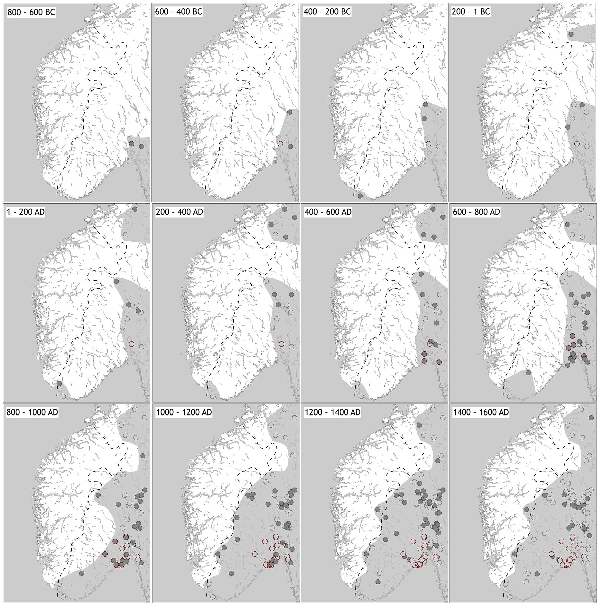
Maps showing the gradual spread of spruce in SE Norway, with data from dated tree species samples from archaeological contexts (n = 364), as well as pollen diagrams (48 sites taken from Høeg et al., 2018). The occurrence from each time period is shown with a filled grey point, with a grey outline for tree species samples and a red outline for pollen samples. Samples from earlier periods are followed to the subsequent time periods, but then as grey or red rings. The dashed line indicates the modern extent of spruce (Øyen and Nygaard, 2020).
The expansion of spruce (Picea abies)
Large quantities of spruce pollen first appear in palynological records from easternmost parts of SE Norway c. 1 AD, and it is argued that this initiated a relatively slow westward expansion (see Figure 6, cf. Giesecke, 2005a; Hafsten et al., 1979; Høeg et al., 2018; Kullman, 1996). However, the pollen data have some shortcomings as our knowledge of the introduction and early distribution is based on a relatively small number of sites. The existence of small amounts of spruce pollen (<5%) in diagrams from before 3000 BC is also difficult to explain (Høeg et al., 2018: 198). Some of this pollen is possibly pollution from peat or gyttja from younger levels in the sediment core or transported to the area by wind (Høeg et al., 2018: 198–199). Therefore, pollen records with varying amounts of spruce pollen in different layers do not offer a clear answer as to when spruce first appeared and when it became more common in different parts of the region (Giesecke and Bennett, 2004: 1532; Høeg et al., 2018: 198–199). It is also possible that small stands of spruce existed in the area during large parts of the Holocene (Bjune et al., 2009; Giesecke and Bennett, 2004).
The 364 dated spruce samples from our database can offer additional information. Our data suggest a three-step spruce expansion into SE Norway (see Figure 6). Three samples are dated between 700 and 500 BC, which initiates a situation where spruce is permanently present in the dataset. 4 Based on pollen data, the BC/AD boundary has been seen as a likely date for the establishment of larger tree stands of spruce along the Swedish border (Giesecke, 2005b; Høeg et al., 2018: 198). If this is not an unlikely example of long-distance transport of firewood, our data suggest that spruce was well established in the area some 100 years earlier. Further, the charcoal data provide details that are only partly recognized based on analysis of the pollen record. In 400–200 BC spruce appears for the first time at the southern tip of the mainland, and then in 200–1 BC it emerges immediately south of the Trondheim Fjord. Between AD 1 and 200, there are samples in the south and in Trøndelag and samples showing that spruce is firmly established in the east and moving into the inland valleys. From about AD 400 to 600 it moves south from the Oslo Fjord, entrenching itself in Vestfold. In the following centuries, spruce moves westwards and deeper into the inland valley system. The species becomes more visible and takes a proportionally increasing space from the sixth century, see Figure 6. By AD 1000–1200 the charcoal data show that spruce had expanded to where the natural delimitation of the species is today (cf. Øyen and Nygaard, 2020: 1790).
Human impact on Holocene forest dynamics
Early human impact – the case of hazel
The phenological and physiological states of wood, the size and/or availability along with societal aspects (subsistence, technology and settlement patterns) are among the factors that determine human selection strategies of wood, and thereby form the archaeological record. The charcoal record is also influenced by combustion processes, taphonomy and importantly, archaeologists’ sampling strategies (Loftsgarden et al., 2013; Théry-Parisot et al., 2010). A last important factor is the methodological possibilities and limitations of charcoal studies (cf. Kabukcu and Chabal, 2021; Schweingruber, 1990). The combination of social and natural factors makes it impossible to produce totally accurate vegetation reconstructions based on charred assemblages from archaeological sites (Théry-Parisot et al., 2010, with further references). Nevertheless, the dated charcoal offers a large amount of information on the past vegetation and more specifically on how humans affected vegetation during the Holocene in SE Norway (cf. Asouti and Austin, 2005; Kabukcu and Chabal, 2021).
One of the notable examples of human-vegetation interaction during the Holocene concerns hazel (Bishop et al., 2015; Finsinger et al., 2006; Holst, 2010; Seppä et al., 2015; Tallantire, 2002). This deciduous tree amounts to only 0.6% of today’s forest volume in SE Norway (Breidenbach, 2016), and it is not even among the 15 most common tree species. In the archaeological record, hazel is the third most common species, see Figure 4. In the categories ‘Settlements’ (n = 134) and ‘Other’ sites (n = 287), hazel makes up 10.4% of the charcoal record (see Supplemental Material, Table 1 for details), 5 indicating a close relationship between human activity and distribution and density of hazel going far back into the Holocene (see Figure 5). Even if climatic effects and the introduction of other species can explain parts of this discrepancy (Seppä et al., 2015), the charcoal data suggest that hazel was more prevalent close to settlements than the natural distribution of tree species should suggest, especially before c. AD 550 (see Figure 5). Previous studies have shown how humans may have aided the introduction and spread of hazel, intentionally or accidentally (Tallantire, 2002: 85, with references). Hazel wood has relatively high calorific value, and in addition hazel pollen production and tree growth are enhanced when vegetation is opened by disturbance or by coppicing or pruning (Finsinger et al., 2006: 624, with references). The amount of hazel in the dataset can also possibly be related to human exploitation of the species for a variety of tasks. Hazel leaves could be used as animal fodder and the bendy stems could be twisted or knotted and used for a variety of wickerwork such as baskets, fences, or fish traps, while the hazelnuts were a nutritious and important food source (Høeg, 1985: 97–98; Nedkvitne and Gjerdåker, 1999).
Forest developments and early farming (c. 2300–800 BC)
Fishing, hunting and gathering were the main forms of subsistence in southern Norway until the final breakthrough of agriculture c. 2300 BC (Prescott, 2012; Prøsch-Danielsen et al., 2018). A significant increase in radiocarbon dates in general (Figure 2), and specifically from cereal grains, tilled fields and farmsteads, indicates a further expansion in farming from 2000 BC (Mjærum, 2020; Solheim, 2021). The shift to a farming economy also meant a shift in settlement patterns, from settling mainly along the coast and waterways, to areas more suitable for early farming inland (Nielsen et al., 2019).
Our data from the Boreal biogeographical region suggest that the region’s early farmers were surrounded by forests that were a fully integrated part of the farming landscape, and that the utilization of the landscape was both well planned and systematic (cf. Bartholin and Mikkelsen, 2012: 109). Early farmsteads and fields were regularly relocated in the region by extensive farming practice (Gjerpe, 2017; Mjærum, 2020; Pilø, 2005), forming a dynamic landscape with a combination of fields, pastures and fallow areas. A large part of the charcoal record after c. 2000 BC consists of birch, hazel, pine, willow, alder and oak, all species that establish themselves quickly on former farmland (Bartholin and Mikkelsen, 2012: 109). The high proportion of these deciduous trees after c. 2000 BC is likely because leaf trees benefitted significantly from the region’s early farming and dynamic land use. Leaf fodder has historically been considered valuable for feeding animals, and especially birch, willow, alder, elm (Ulmus spp.), linden (Tilia cordata) and rowan (Sorbus aucuparia) have been used to sustain the livestock through the winter (Høeg, 1974: 91). The gradual but marked reduction of pine in the record from the boreal biogeographical region between 2300 to 2000 BC can possibly also reflect the change in subsistence and expansion and clearance of farmland. In contrast to deciduous trees, pine is a species that establishes itself more slowly on former farmland and has a lower value as fodder. These factors are likely significant for the reduction of pine in the record from approximately 2300 BC.
Forest developments and Early Iron Age farming (c. 800 BC–AD 550)
A new shift in farming traditions was initiated between 1000 and 500 BC, when a closer integration between livestock breeding and the cultivation of arable land took place (Mjærum, 2020), subsequently leading to a farming expansion after 500 BC (Solheim, 2021). This massive clearance of new fields is reflected in radiocarbon dates and indicates increased human activity in the boreal biogeographical region (Figure 2, Ter Schure et al., 2021). From a human–vegetation perspective, it is significant that the proportion of species in our record seems to have been little affected by this clearance of new farming land. The forest vegetation was still dominated by birch (~40% in the record between 1000 BC–550 AD), followed by hazel (~15–20%), pine (~15–20%), willow (<10%), alder (<10%) and oak (<10%). We suggest that the explanation for the continuity in the proportion of species from c. 800 BC–AD 550 is that the expanding farming communities quickly replaced the natural tree stands in their new surroundings, both by the use of forest resources and by planned forest management (Bartholin and Mikkelsen, 2012).
Besides the general continuity in the proportion of species in the first millennium BC, this is also the time when spruce first appears in our charred wood record (see Figures 5 and 6). Researchers have argued that forest clearance, manuring and periods of leaving the land fallow made room for the expansion of spruce in SE Norway (Bjune et al., 2009: 1080; Overland and Hjelle, 2007: 295, cf. Molinari et al., 2005: 163). Our data support the expansion hypothesis, but we also argue that the westward spread of spruce partly was closely linked to a specific historical event in the region – the first millennium BC farming expansion.
This distribution of species clearly differs from the already discussed situation before 2300 BC, but also from the proportion of species after AD 550 (Figure 5). Explanations for the shift from around AD 550 are undoubtedly complex, and an in-depth discussion of this theme is beyond the scope of this paper. However, the percentage increase of species that often dominate in mature forests (pine, spruce) at the expense of more light-demanding broadleaved trees, was to some degree related to this period’s significant transition of farming traditions. During this process many of the region’s farms were moved or abandoned, in both central and marginal agricultural areas (Herschend, 2009; Iversen, 2013; Iversen and Petersson, 2016; Myhre, 1972; Petersen, 1933: 42). This has been linked to two crises in the mid-sixth century – an outbreak of the bubonic plague and a double volcanic eruption that initiated a long-lasting cooling period (Büntgen et al., 2016; Keller et al., 2019; Sigl et al., 2015; Toohey et al., 2016). A result of these events was that the dynamic system of farms and fields was replaced by a more stable agricultural landscape (Gjerpe, 2017; Grønnesby, 2019; Pilø, 2005), a stability that must have favoured species like pine and spruce in the farming landscape.
Human-vegetation dynamics in the past and present
Above, we have shown how radiocarbon-dated charcoal from archaeological sites can be used as a proxy for studying human–vegetation interaction in the past, and we have argued for a close connection between agricultural developments and vegetation change. The way in which restructuring of agriculture affects the vegetation is, however, not something that merely belongs to the distant past. In 1949, there were more than 200,000 farms in Norway, 11% of them with access to summer farms/shielings. In 2020, the number of farms was reduced to 38,500 in total, and only 781 summer farms were still in use (Bjørlo and Løveberget, 2021). This is only one of many consequences of the transition towards more large-scale and efficient Norwegian agriculture, where an increasingly smaller part of the landscape is considered economically viable to be used for food production and production of animal fodder.
Combined with factors such as climate change, afforestation and altered logging practices, the result has been a threefold increase in forest volume in Norway between 1933 and 2020. The largest expansion is of deciduous trees that spread to areas that once were open pastures, meadows and kept open by logging of firewood (Breidenbach et al., 2020; Tomter and Dalen, 2014, cf. Figure 7). During the last 100 years these developments have been monitored and studied in detail, based on forest inventories and farming statistics.
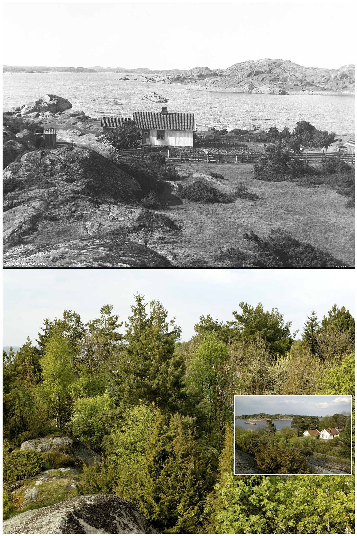
The same place in Hvasser, Tjøme, Vestfold, South-Eastern Norway pictured in 1911 and 2004. In the past, the area was kept open by the production of firewood, animal fodder and grazing. In recent years it is less used and overgrown by dense bushes and trees. Copyright: © Anders Beer Wilse/Norsk Folkemuseum/© Oskar Puschmann/NIBIO.
It will not be possible to obtain the same high-quality data from the distant past, where pollen records and charcoal from archaeological contexts are among the best proxies to offer information about the human impact on forest development.
Concluding remarks
On the basis of 6186 dated tree species samples from 1239 sites we have explored Holocene human–vegetation dynamics in SE Norway. Charcoal from archaeological contexts is a product of intentional human action and the composition of tree species near archaeological sites. In this, it differs from off-site pollen analysis and allows for a reconstruction of vegetation and interactions between humans and the environment at the time of human habitation and activity. This study adds to the current knowledge based on palynological data and expands understanding of the spatial and temporal development of different tree species and human-vegetation dynamics. In closing we wish to emphasize the following points:
The farming practices in the periods 2000–800 BC and 800 BC–AD 550 are characterized by a combination of fields, pastures and fallow areas. These extensive systems of land use, combined with forest management, clearly altered the natural distribution of trees in the boreal biogeographical region of SE Norway and favoured broadleaved species like birch, hazel, alder, oak and willow.
A case in point is the distribution of hazel. Constituting no more than 0.6% of today’s forest volume in SE Norway, this deciduous tree is the third most common species from archaeological contexts. Thus, hazel exemplifies the relationship between human activity and the distribution and density of certain tree species going far back into the Holocene.
The charcoal data indicate that spruce first formed large stands in the south-eastern parts c. 500 BC, centuries earlier than previously assumed, and that its expansion can be broadly explained in three steps: first it arrived in central Eastern Norway north of Oslo Fjord, then in Trøndelag, before it became established in southern parts of Norway. Further, we also argue that the westward spread of spruce was partly linked to a specific historical event in the region – the first millennium BC farming expansion.
Supplemental Material
sj-csv-1-hol-10.1177_09596836221088242 – Supplemental material for Human-vegetation dynamics in Holocene south-eastern Norway based on radiocarbon dated charcoal from archaeological excavations
Supplemental material, sj-csv-1-hol-10.1177_09596836221088242 for Human-vegetation dynamics in Holocene south-eastern Norway based on radiocarbon dated charcoal from archaeological excavations by Axel Mjærum, Kjetil Loftsgarden and Steinar Solheim in The Holocene
Footnotes
Acknowledgements
We thank our colleagues that have provided data for this study and Alan Crozier for proofreading the text. We are also grateful to the two anonymous reviewers for providing helpful comments.
Author contributions
A.M. and S.S. proposed the idea for the study. K.L. and S.S. compiled charred wood data and radiocarbon dates. K.L. and S.S also contributed with analysis of data. A.M., K.L. and S.S. wrote the paper. A.M. coordinated the work.
Funding
The author(s) disclosed receipt of the following financial support for the research, authorship, and/or publication of this article: This paper is the result of a research collaboration carried out as part of the research groups ʻArchaeology by proxyʼ and ʻResource management in prehistoric hunter-fisher-gatherer communitiesʼ at The Museum of Cultural History – University of Oslo. The data collection is part of the project ʻVolcanic Eruptions and their Impacts on Climate, Environment, and Viking Society in 500–1250 CEʼ, funded as a FRIPRO Toppforsk project by the Research Council of Norway (project number 275191).
Notes
References
Supplementary Material
Please find the following supplemental material available below.
For Open Access articles published under a Creative Commons License, all supplemental material carries the same license as the article it is associated with.
For non-Open Access articles published, all supplemental material carries a non-exclusive license, and permission requests for re-use of supplemental material or any part of supplemental material shall be sent directly to the copyright owner as specified in the copyright notice associated with the article.