
Abstract
Long-term paleofire perspectives provide key information on natural and human-derived land cover changes. The last few millennia are crucial to understanding the future of wildfire threats, since the increasing global temperatures are expected to have an impact on regions previously assumed to not be endangered. In this study we investigate the interplay between changing climatic conditions, land cover transformation, fires, and human activity based on the first 1750-year-long macrocharcoal record derived from varved sediments of Lake Jaczno, located in northeast Poland. The study is supported by macrocharcoal morphotype analysis, pollen and historical data, and statistical analysis, which revealed that in the vicinity of the lake both low- and high-intensity fires may have occurred. Most of them were set by humans, but in some periods biomass burning was favored by droughts or even derived by natural causes (i.e. lightning). Human-induced fires are especially evident between AD 1081 and 1283. This period corresponds to the peak activity of the Jatvings tribe in the region and the related deforestation for agrarian purposes. Fire combined with human activity and deforestation in the area impacted the limnological processes increasing primary productivity and shifts in water mixing regime.
Introduction
It is very likely that higher temperatures with shorter but more intense precipitation episodes will be observed worldwide (IPCC, 2013). This will result in longer gaps between rainfall/snowfall, which favors droughts (Przybylak et al., 2020). Prolonged droughts, in turn, make terrestrial ecosystems, especially forests, more vulnerable to disturbances like windstorms, pathogens, insect outbreaks, and wildfires (Kundzewicz et al., 2018; Słowiński et al., 2019). Fire is a natural component of many ecosystems that drives changes in biogeocycles and composition of vegetation (Bowman et al., 2009; Carcaillet et al., 2002; Whitlock and Larsen, 2001). The interplay of climate and human forcings cause megafires in different parts of the world, especially in California, Australia, and Siberia (Kelly et al., 2020; Rogers et al., 2020). These fires lead to serious consequences in populated regions, but also irreversibly affect the environment and climate. According to the European Commission, the rising temperature will be accompanied by more frequent wildfires even in regions previously unaffected (San-Miguel-Ayanz et al., 2018). In recent years, severe wildfires have occurred in countries such as Sweden, Germany, or Poland (Bonk, 2019), which were previously considered as low-risk regions due to the assumed low flammability of forests (Adámek et al., 2015). However, despite the increasing research on past fire regimes (Vannière et al., 2014), especially in central Europe (Carter et al., 2018; Dietze et al., 2018; Lamentowicz et al., 2020; Marcisz et al., 2020), a knowledge gap in understanding complex interrelations between climate, human activity and vegetation fires still exists (Feurdean and Vannière, 2017). Moreover, a little attention has been paid to the post-fire implications for limnological processes. Therefore, further reconstructions are needed to better understand the long-term role of fire.
Sedimentary charcoal analysis is a well-established approach for researching past climate–fire–vegetation relationships as well as human–environment interactions (Courtney Mustaphi and Pisaric, 2013; Dietze et al., 2019; Kittel et al., 2021; Power et al., 2008). Particulate charcoal is produced by the incomplete combustion of organic matter and therefore provides direct evidence of burning (MacDonald et al., 1991; Scott, 2010). Charcoal particles within the sediment record may have a local (within the watershed), regional, or even global origin (Conedera et al., 2009) because – depending on size – they can be transported distances as short as several meters up to hundreds of kilometers. Although the definition of the macrocharcoal size varies in literature, we define macroscopic charcoal as pieces ⩾150 μm (Enache and Cumming, 2006), which makes them big enough for the cell structure observation. Macrocharcoal is usually deposited close to the fire’s source and is therefore suitable for reconstructing local fire events (Whitlock and Larsen, 2001). However, investigations on coarse airborne charcoal particles (up to a few centimeters) showed that they can be transported as far as 20 km from the emission source (Pisaric, 2002; Tinner et al., 2006; Vachula and Richter, 2018) and can thus serve as a proxy of subregional to local fire appearance. Charcoal morphotypes reveal important insights into past fires, reflecting different fuel sources and burn conditions (Enache and Cumming, 2006; Feurdean et al., 2020; Vachula et al., 2021). It was shown by Jensen et al. (2007) that the charcoal morphotypes vary through time and thus reflect changes in vegetation and fire regimes.
Sedimentary charcoal can be found in various natural archives such as, for instance, soils, peatbogs, or lakes (Tolonen, 1983). Annually laminated (varved) sediments are particularly valuable because they have the potential to help in developing accurate, high-resolution chronologies expressed in calendar years (Zolitschka et al., 2015). Although the attainable temporal resolution of the proxy data is largely limited by the sampling resolution, varved lake sediments track past fire events in a resolution that is usually unavailable from other archives. When supported by historical data, sedimentary charcoal records can significantly improve our understanding of the human influence on land transformations and inform about the scale and range of the extreme events (Brázdil et al., 2005; Przybylak et al., 2020).
Although a number of sites have been investigated to reconstruct wildfire regimes in Poland (e.g. Dietze et al., 2018, 2019; Gałka et al., 2013, 2014; Lamentowicz et al., 2008, 2020; Marcisz et al., 2015, 2017, 2019, 2020; Wacnik et al., 2014, 2016) the relationships of climate change, human impact, and vegetation are still not well understood. Combinations of high-resolution proxies, chronology, macrocharcoal and related morphotypes, and historical data have rarely been presented. However, this may shed light on local and regional fire drivers, as wildfire intensity and frequency depend not only on the vegetation’s flammability and the ignition source but also on climate (Belcher et al., 2010; Rocca et al., 2014; Vachula et al., 2020). An ecological assessment of baseline conditions of individual sites is thus substantial for examining the long-term interactions among fire, climate, vegetation, and human activity.
This study is of Lake Jaczno, located in northeast Poland. Sediments of this lake have been studied in detail by several authors (Butz et al., 2015, 2017; Gałka et al., 2019; Makri et al., 2021; Poraj-Górska et al., 2017; Weisbrodt et al., 2016), revealing an excellent varve record, which combined with a well-documented human impact history in this region yields a unique opportunity for further investigations supported by available data.
In this paper, we present a continuous ~1750-year-long macrocharcoal profile obtained from the varved Lake Jaczno, the first to date, with the aim of answering two research questions: (1) What was the interaction between changing climatic conditions, vegetation, environment, fires, and human activity in the Polish Lowland? and (2) How did fire episodes influence the limnological processes and sedimentation?
Study site
Lake Jaczno is located in the Suwałki Lakeland, northeastern Poland (54°16′26.3″N; 22°52′20.3″E) at 163 m a.s.l (Figure 1a). The landscape developed mostly during the Pomeranian Phase of the Vistulian (Weichselian) glaciation period, about 15 ka BP (Ber, 1982). Thus, this region of Poland is characterized by post-glacial deposits such as glacial tills, sands, gravels, boulders, and silts (Detailed Geological Map of Poland (in Polish: Szczegółowa Mapa Geologiczna Polski)). The study area is characterized by diverse relief with numerous ice melt-out forms. Lake Jaczno is located in one of these forms (Smolska, 2011) where the lacustrine sedimentation started ca. 9500 cal BP (Makri et al., 2021). The slopes surrounding the northern part of the lake are steep (up to 40°; Figure 1c) which favors erosion processes; the steepness of the slopes on the southern part do not exceed 10°. The total catchment area is ~9 km2 and is covered by cambisols and podzols in the northern part and ferric cambisols in the southeastern part (Poraj-Górska et al., 2017). Nowadays, the southern and eastern parts of the catchment are covered in a forest dominated by birch, alder, and spruce. The rest of the area is predominantly used for agricultural purposes (Figure 1b; Poraj-Górska et al., 2017). The climate of the region is continental with a mean annual temperature of 6.8°C and a mean annual precipitation sum of 600 mm (IMGW-PIB, http://klimat.imgw.pl).
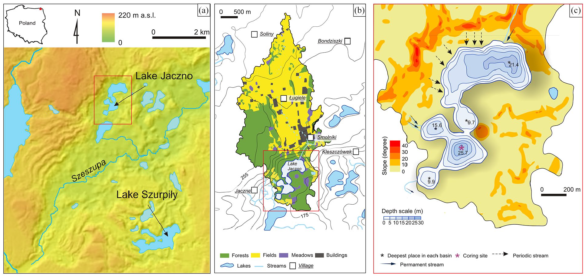
Location of the study site (Digital Elevation Model courtesy of the Polish Head Office of Geodesy and Cartography). Lake catchment is within the area outlined with a red rectangle. Topography of lake catchment and surrounding area (a), land-use within the watershed of the lake (b, the outlined area) and bathymetry of Lake Jaczno and catchment slope steepness (c); (b) and (c) modified after Poraj-Górska et al. (2017).
Lake Jaczno has three permanent inflows and one outflow (Figure 1b and c). Additionally, several periodic streams supply the northern part of the lake (Figure 1c; Butz et al., 2017; Poraj-Górska et al., 2017; Weisbrodt et al., 2016). Lake Jaczno is a hard-water, mesotrophic lake with a total surface area of 0.41 km2. Five distinct basins divided by shallow sills can be distinguished (Figure 1c). The exchange of water between the basins is thus limited. The maximum depth of the southern basin is 25.7 m, promoting thermal and chemical stratification of the water column and natural meromixis (Butz et al., 2017), resulting in a seasonally anoxic hypolimnion.
Materials and methods
Sediment core collection and archiving
A 251-cm-long sediment core (JAC-11/4) was retrieved from the deepest part of the southern basin in 2011 using a UWITEC gravity corer and a 90-mm-diameter PVC tube. The core was split lengthwise and then lithologically described and photographed with a digital camera at the University of Gdańsk, Poland. Afterward, the core was stored in a cold room at a temperature of 4°C prior to further analysis.
Chronology
The final sediment chronology is adapted from Butz et al. (2017) and is based on varve counting combined with measurements of 210Pb and 137Cs radionuclides and 14C dating. Varves were counted by four individuals on near-infrared images of the sediment core and flatbed scans of resin blocks, according to the procedure proposed by Bonk et al. (2015) and Żarczyński et al. (2018). The 210Po activity was measured by alpha spectrometry and the activities of 137Cs and 226Ra were measured by gamma spectrometry at the University of Gdańsk, Poland. Details of the laboratory procedures are presented in Tylmann et al. (2016).
Macrocharcoal analysis
Macroscopic charcoal particles (MAC) with a size ⩾150 µm allowed for recognition of cell structures and were used to reconstruct the local fire history. The sediment profile of JAC-11/4 was sampled with 1 cm resolution continuously throughout the record. Afterward, the samples were bleached to create a more visible contrast between the charcoal and the organic matter remains. The carbonates were removed with 10% HCl. The samples were then washed gently through a 150 µm sieve and the MAC particles were counted under a stereoscopic microscope with 40–60× magnification. The MAC was divided into three size groups: 150–300 μm (MAC150), 300–500 μm (MAC300), and >500 μm (MAC500). To gain insights into fuel features, the charcoal particles were separated into seven distinct morphological groups. No experimental studies have been carried out in our research, so we rely our interpretation on insights gained from other studies of charcoal morphotypes (Enache and Cumming, 2006; Feurdean, 2021; Mustaphi and Pisaric, 2014) and propose potential fuel sources for listed morphotypes as follow:
pieces showing irregular shape with a reticulated pattern, potentially originated from leaves,
fragments of irregular shape and solid structure being most likely pieces of punky wood,
pieces presenting geometric shape with visible foliations or lignified attributed to wood fragments,
fragments showing geometric shape without pattern with smooth surface linked to wood or leaves,
needles/leaf veins/roots elongated fragments with ramifications,
Graminoids (grass cuticles/sedge/fragments of larger particles) showing elongated shape usually flat, plain, or with voids,
partially burnt, elongated fragments often with visible cell layers. However, as only one piece of this group was found, it was excluded from further analysis. The grouping was done with the assumption that low-intensity cool surface fires will produce more grass/shrub charred pieces, while after a hot crown fire episode more woody charcoal pieces will be found.
Charcoal accumulation rates (CHAR, particles cm−2 yr−1) and local fire episodes were obtained with CharAnalysis software (Higuera, 2009; available online) by decomposing the record into the charcoal background (CHARback) and a peak component (CHARpeak). Before calculating charcoal accumulation rates (CHAR) and the peak analysis, charcoal counts, sample volume, and sample were interpolated to the median sample resolution. All CHAR values were shifted by a constant (1) and transformed via log10. CHARback was determined by applying a robust, locally weighted regression (LOWESS) with a moving-window width of 500 years (SNI >3.0; Kelly et al., 2011). CHARpeaks were calculated as residuals with locally defined threshold, where base threshold values on a percentile cut-off of a noise distribution were determined by the Gaussian mixture model.
Pollen data
Pollen analysis was performed on 121 samples from Lake Szurpiły (Kinder et al., 2019), which is situated approximately 5 km southeast of Lake Jaczno (Figure 1a). The Lake Szurpiły sediments reflect local vegetation changes, which are also representative of the vicinity of Lake Jaczno. The pollen slides were prepared and microscopic analysis was carried out in accordance with the standard procedure (Berglund and Ralska-Jasiewiczowa, 1986).
In each 1 cm3 sample, at least 800 sporomorphs of terrestrial plants as well as all accompanying pollen grains and the spores of aquatic and mire plants were counted and identified using the available keys (e.g. Beug, 2004; Moore et al., 1991). The percentage value of each pollen taxon was calculated in relation to the total sum of tree and shrub (AP) and herbaceous plant pollen (NAP).
The NAP pollen taxa were grouped into eight groups according to, for example, Behre (1981, 1988) and Berglund and Ralska-Jasiewiczowa (1986). The plants of disturbed biotopes (ruderals) were additionally divided into two major and minor ones on the basis of pollen production, as proposed by Poska et al. (2004):
(1) Cultivated land: Agrostemma githago, Avena-type, Centaurea cyanus, Cannabis sativa cf., Cerealia-type, Fagopyrum, Helianthus-type, Papaver, Secale cereale, Triticum
(2) Ruderals minor (minor pollen production): Brassicaceae undiff., Gratiola officinalis, Plantago lanceolata, Plantago major/media, Plantago maritima s,l, Plantago media, Polygonum aviculare-type, Polygonum persicaria-type, Rumex acetosa/acetosella-type, Rumex acetosella-type, Solanum nigrum-type, Urtica undiff.
(3) Ruderals major (major pollen production): Artemisia, Calluna vulgaris, Chenopodiaceae, Symphytum
(4) Grazed forest: Anemone-type, Melampyrum, Pteridium aquilinum
(5) Dry meadow: Centaurea jacea-type, Centaurea scabiosa-type, Juniperus communis, Jasione montana
(6) Wet meadow: Cyperaceae undiff., Carex-type, Filipendula, Pedicularis, Thalictrum, Valeriana undiff.,
(7) Meadow: Anthemis-type, Cirsium-type, Fabaceae undiff., Knautia arvensis, Plantago major, Potentilla-type, Ranunculaceae undiff., Ranunculus acris-type, Ranunculus ficaria, Ranunculus flammula-type, Rhinanthus, Rumex acetosa-type, Trifolium pratense-type, Trifolium repens-type, Vicia-type,
(8) General open land indicators: Apiaceae, Aster-type, Bidens-type, Cannabis/Humulus, Caryophyllaceae undiff., Cichorioideae, Dianthus-type, Mentha-type, Mercurialis perennis, Poaceae undiff., Rubiaceae, Rumex undiff., Convolvulus arvensis, Epilobium angustifolium, Gypsophila-type, Rosaceae undiff., Silene-type, Tussilago-type, Viola, Xanthium-type cf.
The results are presented as a simplified percentage pollen diagram drawn in riojaPlot 1.03 (31/05/2021). Apart from the pollen curves of the above-mentioned groups, this diagram includes the curves of selected trees and shrubs, which were drawn in the following order:
(1) high-competitive, shade-tolerant taxa ordered by their edaphic demands – from damp, fertile soils to light soils (Alnus, Ulmus, Fraxinus excelsior, Carpinus betulus, Tilia cordata, Quercus),
(2) low-competitive, light-demanding taxa (Corylus avellana, Betula alba-type, Pinus sylvestris, Populus, Salix, Picea abies).
Statistical analysis
The data were analyzed using R 4.1.2 (R Core Team, 2021). Data processing and visualization were conducted with tidyverse 1.3.1 (Wickham et al., 2019). To achieve equidistant CHAR and pollen data, missing values between the samples were linearly interpolated with zoo 1.8-9 (Zeileis and Grothendieck, 2005). Before the multivariate analysis, the pollen percentage data were shifted by 0.01 and square-root-transformed, while the CHAR values were log-transformed. Afterward, the data were scaled and centered. A stratigraphically constrained cluster analysis (CONISS; Grimm, 1987) of pollen data was performed with rioja 0.9–26 (Juggins, 2020). The main variability directions of the pollen and CHAR data were evaluated with principal component analysis (PCA), visualized with ggfortify 0.4.13 (Tang et al., 2016). The numbers of significant clusters and components were tested against the broken-stick model (Bennett, 1996). Generalized additive models (GAM) were used to compare a smoothed time series of CHAR flux and total organic matter (LOI550 from Butz et al. 2017). The GAMs were fitted with mgcv 1.8–38 (Wood, 2020) using the “REML” method and k = 30. Binned correlation between irregularly spaced time series of CHAR and LOI550 fluxes was calculated and tested with the BINCOR 0.2.0 package (Polanco-Martínez, 2018). Adjustment and transformation between the date scales were achieved with the era 0.3.1 package (Roe, 2021).
Historical data
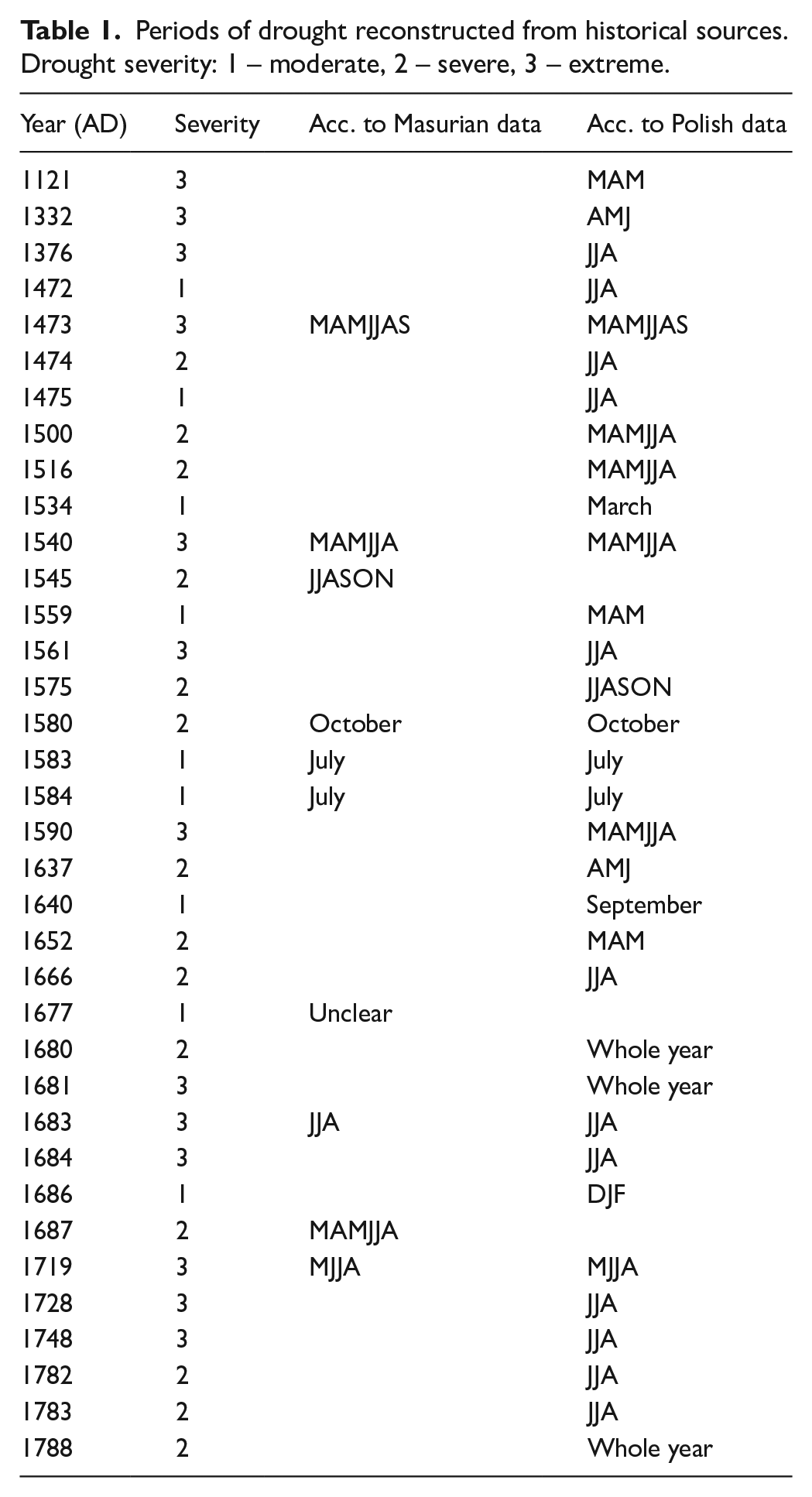
As there is a lack of appropriate historical sources for the Suwałki region, the drought reconstruction was based on data collected for the Masuria region, the closest one to the study site, and completed with general information about droughts in Poland. It is composed of different types of historical sources such as annals and chronicles written by Prussian and Polish chroniclers as, among others, Marcin Murinius (Wójcicki, 1843), Jan Długosz (Długosz et al., 1997, 2000), Maciej z Miechowa (Maciej z Miechowa, 1521), and Marcin Kromer (Cromer, 1555). Additionally, we used diaries (e.g. by Jan Antoni Chrapowicki), documents and correspondence (especially documents of the Teutonic Order and the Duchy of Prussia), records of public administration, newspapers, and books. Most information covers the period from the 15th to the end of the 18th century. All historical data were evaluated according to their credibility and were classified along a 3-item scale: 3 related to “extreme” droughts, 2 to “severe” droughts, and 1 to “moderate” droughts (Table 1; Przybylak et al., 2020). Extreme droughts (megadroughts) are considered to last at least 2–3 months and are characterized by a significant and negative influence on crops, water supply, and increased danger of fire. Chroniclers sometimes used more emotional words in order to describe their exceptional character (“[. . .] anno 1473 fuit estas feruentissima et siccitas inaudita et in quibusdam terris ignis sub terra succensus usque ad arenam fuit,” which can be translated as: “[. . .] in 1473 there was a large heatwave that led to unprecedented drought, that in some instances fires burnt ground severely” (Kalitowski, 1878). Severe droughts were shorter, usually lasting up to 1–2 months. However, droughts that lasted longer but had less severe effects than those caused by megadroughts were also included in this group. Severe droughts were described in detail by chroniclers and writers due to their contribution to crop failure or water shortages, to the point where mills on rivers could no longer function, that is, in 1687 “Aliści pożar 1687 r, zniszczył folwarki i willę w Ryni, posucha spowodowała nieurodzaj i biedę” (Załęski, 1902) [transl. The fire in 1687 destroyed the granges and mansion in Ryna and drought caused crop failure and poverty]. The stronger a drought was, the more frequently it was described in different sources. Moderate droughts are only briefly mentioned without any consequences described. Therefore, it can be assumed that some moderate droughts were not recorded in the historical archives.
Periods of drought reconstructed from historical sources. Drought severity: 1 – moderate, 2 – severe, 3 – extreme.
Results
Sediment lithology and age-depth model
The 251 cm-long JAC-11/4 core is almost entirely varved with intercalated thin layers of homogenous sediments. The varves are very well preserved with clear boundaries. Each varve is composed of a calcite layer followed by an organic-rich layer and sometimes a clay-rich layer. In this paper we adopt the lithological zones proposed by Butz et al. (2017), with minor modifications (Figure 2):
JAC-1 (251–160 cm) – olive, varved sediment composed of calcite and biogenic layers. The clay-rich layer is either very thin or not present.
JAC-2 (160–138 cm) – olive-brown, varved sediment, which typically consists of laminae couplets formed from calcite and clayey layers.
JAC-3 (138–94 cm) – also olive-brown, varved sediment. The varves are composed of calcite and biogenic layers with sparse clayey layers. At the top of this zone, nine thin, homogeneous layers (a total thickness of approx. 45 mm) were observed, forming sharp but non-erosive horizons which were recognized as flood layers (Makri et al., 2021).
JAC-4 (90–64 cm) – dark olive-brown, varved sediment with a typical varve structure consisting of calcite and clay. In two sections (94–90 and 79–72 cm) a high concentration of charcoal was observed (Butz et al., 2017).
JAC-5 (64–0 cm) – light brown/reddish, varved sediment composed of calcite and biogenic layers. Seven thin (a total thickness of approx. 35 mm) and three thicker (approx. 75 mm) homogeneous layers were observed in this zone. Similarly to zone 3, they were recognized as flood layers (Makri et al., 2021).
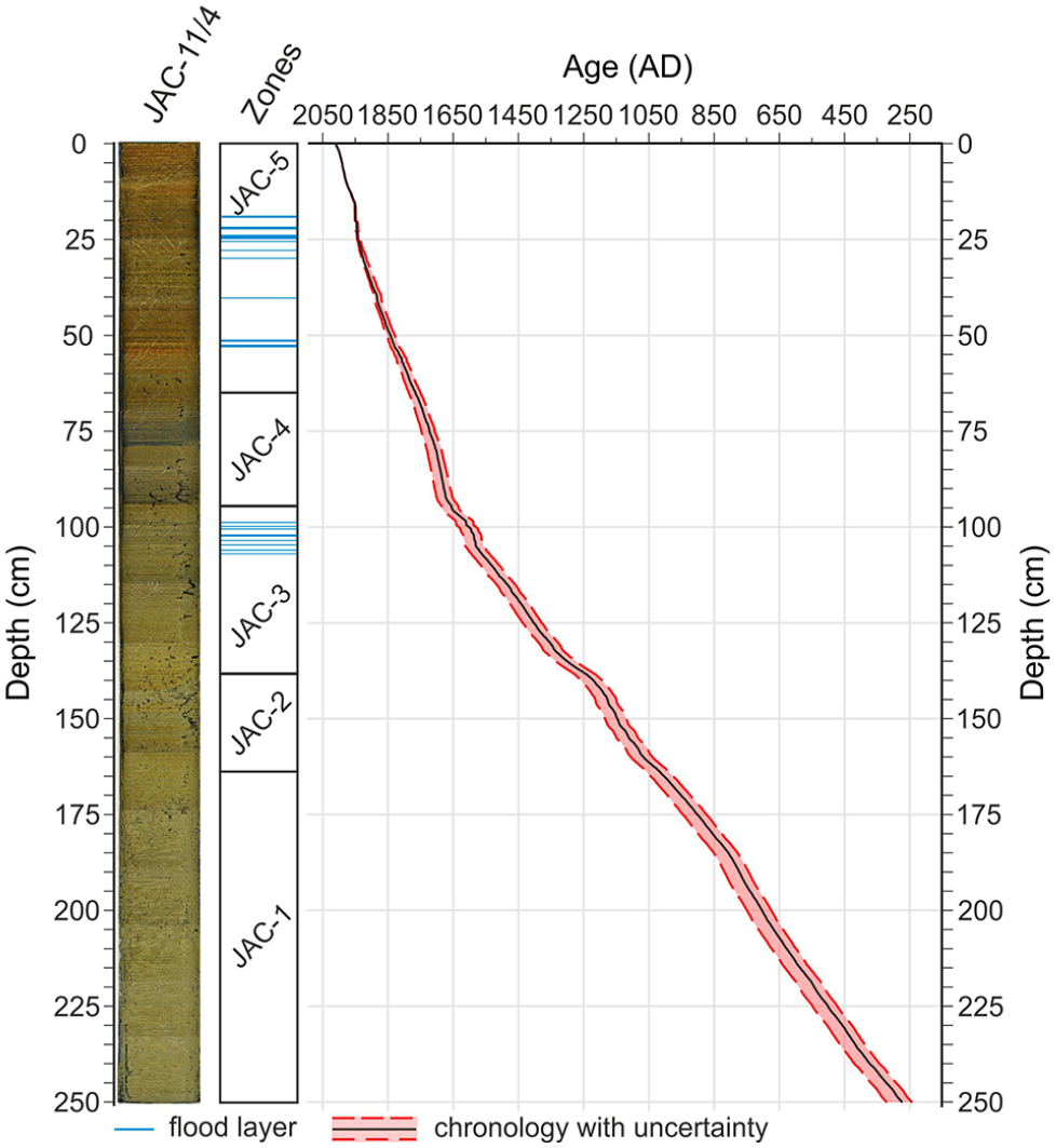
Lithology and chronology for Lake Jaczno. Blue lines correspond to homogeneous layers described by Butz et al. (2017) and recognized later as flood layers by Makri et al. (2021).
Varve counting revealed that the JAC-11/4 profile consists of 1739 +30/−47 varve years (Figure 2). Therefore, the profile covers the time period from ca. AD 270 +30/−47 to 2011 (the year of coring). The sedimentation rate was similar throughout the profile (mean: 1.44 mm yr−1 ± 1.56 (1 SD)), with higher values toward the top of the core.
Charcoal concentrations and morphotypes
Two hundred fifty-one samples were investigated in order to reconstruct the local fire history for the vicinity of Lake Jaczno. At least one piece of macroscopic charcoal was present in about 94% of the samples (no charcoal was found in 16 out of the 251 samples). The samples covered the entire time period (from AD 274 +30/−47 to AD 2011) with a mean resolution of 7 years. The macroscopic charcoal concentration (MAC300 and MAC500) and influx (CHAR) values had a similar pattern, with the highest values being observed in two periods: AD 1075–1175 and AD 1550–1775 (Figure 3). A small difference was observed in the topmost part of the record (AD 1800–2000), where the values for CHAR and MAC300 were higher than for MAC500. The smallest particles (MAC150) displayed a pattern similar to CHAR from the bottom of the record until ca. AD 550 +29/−47. A small increase in MAC150 flux was observed at ca. AD 1075–1175, but the most prominent one was in the topmost part, that is, AD 1800–2000. The average CHAR concentration was 5 pieces per cm−3 (min: 0; max: 34), while the average accumulation was 0.2 particles cm−2 yr−1 (min: 0; max: 0.79). The fire frequency was variable, from 3.6 peaks 500 yr−1 up to 7 peaks 500 yr−1, in the lower part of the profile. The lowest frequencies were observed at ca. AD 800 (2.5 peaks 500 yr−1) and at the top of the profile (ca. 1.6 peaks 500 yr−1).
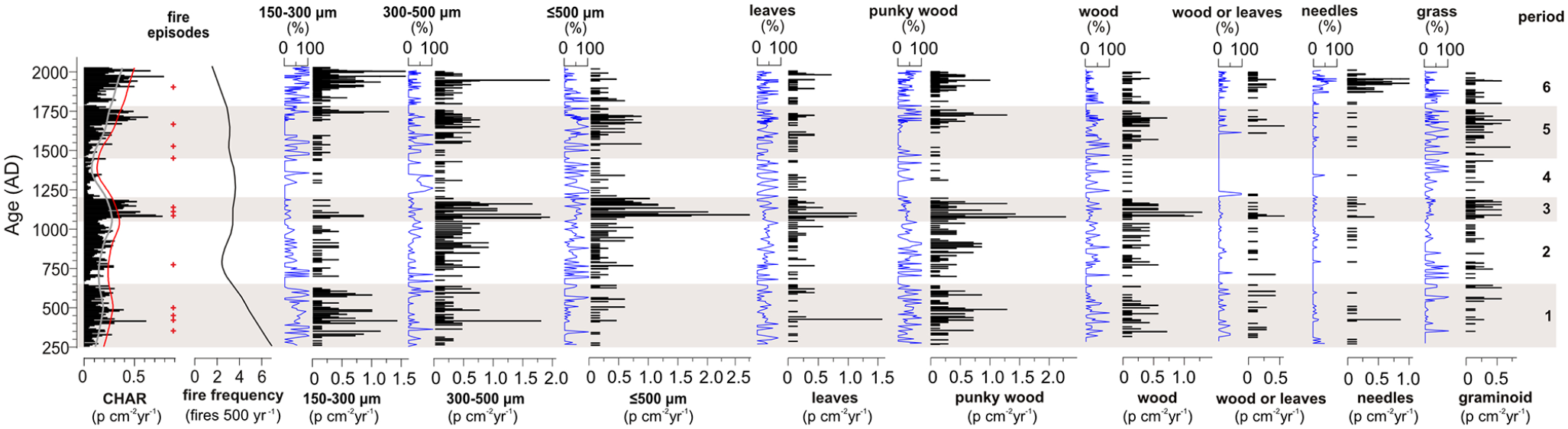
Reconstructed fire events and fire frequency for Lake Jaczno based on macroscopic charcoal counts, divided into three size groups (150–300 μm, 300–500 μm, and >500 μm), percentage of total assemblage (blue curves), and flux of six morphotypes (p stands for “particles”). Periods relate to different charcoal accumulation in time: 1 – AD 250–650 high; 2 – AD 650–1050 low; 3 – AD 1050–1200 the highest; 4 – AD 1200–1452 very low; 5 –AD 1452–1775 high; 6 – AD 1775–2011 high.
Over the study period, the fire activity can be divided into six periods of different fire regimes based on CHAR and charcoal morphotypes (Figure 3).
AD 250–650: High charcoal concentration
Macroscopic charcoal was present in high concentrations and the peak analysis revealed four local fires. MAC350 particles were most frequent during the fire in AD 353 +29/−47 (up to 0.20 particles cm−2 yr−1, which translates to ca. 100% of the total assemblage). The particles were either fragments of punky wood or a living wood with graminoid particles occurring occasionally. The second fire took place in AD 423 +29/−47 (up to 0.60 particles cm−2 yr−1); MAC150–300 were the predominant type, with leaves, punky wood, and needles being the most abundant particles. The third fire event was recorded in AD 451 +29/−47 (up to 0.23 particles cm−2 yr−1). In this case, charcoal pieces between 150 and 300 μm prevailed, with punky wood being the most abundant. The last fire event took place in AD 500 +29/−47 (up to 0.35 particles cm−2 yr−1). MAC150 was dominant particle size (up to 1.0 particles cm−2 yr−1; ca. 90%). The fuel originated mostly from punky wood and needles.
AD 650–1050: Low charcoal concentration
The period between AD 650 and 1050 was characterized by a low charcoal concentration. Only one local fire can be distinguished; it occurred in AD 773 +28/−46 and the charcoal concentration increased up to 0.29 particles cm−2 yr−1. Most of the charcoal was classified as MAC500 (ca. 0.75 particles cm−2 yr−1; ca. 60%), but other pieces were also present. Punky and living wood particles were the most abundant, but some graminoids were also observed.
AD 1050–1200: The highest charcoal concentration
The most prominent local fire was observed at ca. AD 1081 +28/−38, with a concentration as high as 0.37 particles cm−2 yr−1. However, it seems that this event was prolonged or even happened later, as the neighboring peak was 0.78 particles cm−2 yr−1 (AD 1088 +28/−38) and no redeposited material was observed in the sediment structure, which excludes secondary charcoal delivery. Most of the pieces were recognized as MAC500 (up to 1.75 particles cm−2 yr−1; ca. 50%) with a considerable contribution of MAC150 and MAC300 pieces. The charred particles included leaves fragments, punky and living wood particles, and a mixture of needles and graminoid pieces. The concentration of charcoal in the second (ca. AD 1109 +28/−38) and third (ca. AD 1137 +28/−38) fire events of this phase were lower (up to 0.51 particles cm−2 yr−1 and 0.38 particles cm−2 yr−1, respectively). However, the dominant size of the particles as well as charcoal morphotypes were similar to those from the fire in AD 1081/1088.
AD 1200–1452: Very low charcoal concentration
This period was characterized by a very low concentration of charcoals. Although some pieces of charcoal were identified in this core section, they did not pass the test to be classified as distinct fire events.
AD 1452–1775: High charcoal concentration
Between AD 1452 and AD 1775, CHAR peaks revealed three fire episodes, in ca. AD 1445 +25/−34, 1536 +24/−33, and 1662 +21/−30. The first one (CHAR of up to 0.21 particles cm−2 yr−1) was characterized by small charcoal pieces (MAC150), which were recognized as punky wood and graminoids. Pieces of wood, graminoids, leaves, and needles occasionally were observed in two size groups – MAC150 and MAC500 – during the second event, with the CHAR value reaching 0.28 particles cm−2 yr−1. The third fire, with the highest CHAR values (up to 0.37 particles cm−2 yr−1), was composed of charcoal pieces larger than MAC300. Macroscopic charcoal included all morphotypes but needles, with the highest amount represented by punky and living wood as well as graminoid fragments.
AD 1775–2011: High charcoal concentration
The most recent period started at ca. AD 1775 +16/−20 and continues to the present day. The CHAR values increased (up to 0.50 particles cm−2 yr−1) and one fire was noted at ca. AD 1893 +13/−6. The most frequent size of particles was MAC150, but a few MAC300 particles were also noted. Morphotype analysis revealed punky wood, needles, and leaves. There are three distinct peaks visible at the top of the profile (ca. AD 1954, 1991, and 1998). However, they did not pass the peak analysis test and were not considered fire events.
Vegetation change and human impact
The stratigraphically constrained hierarchical analysis (CONISS) performed on selected pollen taxa identified three statistically significant clusters:
Zone 1 (AD 276–787): Minor or insignificant human impact
Zone 1 had a high percentage of the trees and shrubs taxa, which were more or less stable throughout the zone. However, around AD 700 they started to decrease upwards the profile. The exception was Betula alba-type, which displayed an increasing trend. There was a minor or insignificant human impact as shown by cultivated land indicators (Figure 4). The low proportion of grazed forest, meadow, and open land taxa suggests dense forest with only rare clearances.
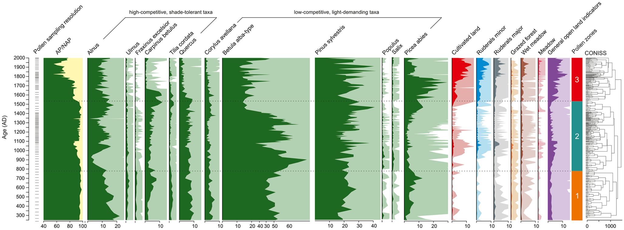
Pollen percentage diagram for Lake Szurpiły (located approx. 5 km southeast of Lake Jaczno) along with pollen zones obtained from CONISS.
Zone 2 (AD 787–1543): Moderate human impact
There are rapid declines in the values of Alnus, Picea abies, and Carpinus betulus at the beginning of zone 2 (Figure 4) with the minima appearing ca. AD 850–900, which suggest an opening in the forest canopy. These changes are accompanied by the maximum (ca. 60%) of Betula alba-type at ca. AD 900 and its progressive decline afterward. Until ca. AD 1100, the proportions of trees and shrubs decreased, but between AD 1100 and 1500 clear increases can be observed in their numbers. At the top of zone 2, the share of Betula alba-type trees decreased to approx. 20%, while Pinus sylvestris, Picea abies, Carpinus betulus, and Corylus avellana had an increasing trend. The cultivated land and grazed forest taxa were most pronounced between ca. AD 925 and 1125. The abundance of open land indicators gradually increased from the beginning of zone 2, but decreased rapidly after AD 1100 and remained low until the end of this zone.
Zone 3 (AD 1543–2006): High human impact
The pollen values of trees and shrubs progressively decreased through zone 3 (Figure 4) until ca. AD 1950, when the trend reversed upwards. The most noticeable changes were in Quercus, Carpinus betulus, and Picea abies. The proportions of the first two trees decreased significantly at the beginning of the zone 3. Whereas, the share of Picea abies increased gradually at first, and only then, at the beginning of the 19th century, decreased sharply. The taxa related to human activity – cultivated land and meadow – and ruderals increased substantially, reaching >5%. This illustrates a progressive opening of the landscape. There was a small decline in the taxa related to human activity between ca. AD 1960 and 1970, but afterward the content of these taxa increased until the top of the profile.
Relationships between land-use change and fire events
In order to investigate the relationships between macrocharcoal concentration (CHAR) and pollen taxa, PCA was performed. Overall, the analysis explained only 30.15% of the variance, with 22.19% due to PC1 and 7.96% by PC2. The PCA biplot (Figure 5) reveals that variables correlated to PC1 represent gradual vegetation change. However, low variance explained by the first two components suggests that the rest of the overall variance is better explained by the other processes that are not strictly dependent on the climate conditions and fire severity. Pollen zone 1 reflects a predominance of trees or natural forests with negligible human activity. Interestingly, the oldest samples (between AD 276 and 360) were separated from this group. Pollen zone 2 reveals increasing human pressure/disturbance. The youngest pollen zone 3, shows land transformation related to human presence in the catchment.
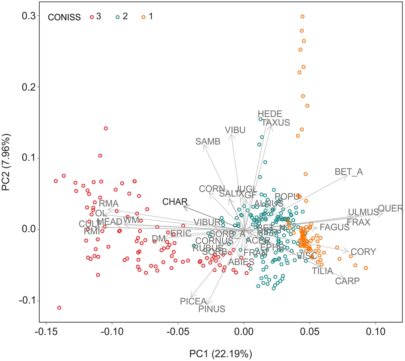
PCA biplot based on selected pollen taxa and CHAR.
Generalized additive models (GAM) were used to estimate smoothed trends of both CHAR and total organic matter (LOI550) fluxes (Figure 6a), which were then compared (Figure 6b). Although the CHAR and organic matter series were not identical, high similarity of curves was visible. Moreover, higher values of organic matter correspond to the fire events reconstructed from macrocharcoal analysis. In general, each fire event was followed by an increase in organic matter deposition, but these changes were gradual and lasted up to several decades. Until the 11th century, LOI550 responses to fire were relatively small when compared to the events further up the core. An especially sharp, sudden increase in organic matter deposition started at ca. AD 1600 +23/−32 and was accelerated by the fire event in AD 1445 +25/−34. Overall, both time series exhibited high similarity, with signs of local shifts, which could be attributed to sampling resolution. Binned correlation between the raw data points indicated statistically significant but moderate relationship between the series with r = 0.38 (df = 176, p < 0.01).
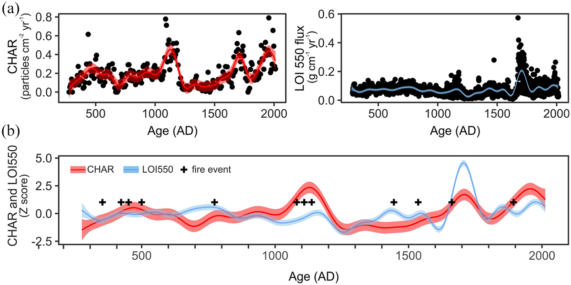
Time series of CHAR flux (particles cm−2 yr−1; a, upper-left panel) and LOI550 flux (g cm−2 yr−1; a, upper-right panel) with smoothed trends based on generalized additive models (GAM; bands show approximate 95% confidence intervals). Comparison of scaled and centered GAM trends with fire events marked (b, lower panel).
Droughts in the Suwałki region based on historical data
The data related to the Early and High Medieval periods are sparse; only three extreme droughts, in AD 1121, AD 1332, and AD 1376, were mentioned. More complete data are available from the second half of the 15th century. A 3-year period, AD 1472–1474, can be considered a long dry period, peaking with the megadrought in AD 1473, which occurred in almost the whole of Europe. The period before AD 1540, when one of the most severe droughts in Europe occurred, can be considered unusually dry (Brázdil et al., 2020). Dry years were more prevalent in the 1580s, with extreme drought in AD 1590 and in the beginning of the 1680s. Based on an analysis of all available sources, the droughts in the Masuria region have been reconstructed to the late 1800s; extreme droughts occurred in AD 1719, AD 1728, and AD 1748. The last two decades of the 18th century can be also considered rather dry.
Discussion
The use of historical data in paleostudies has enjoyed a growing interest in past decades providing a more accurate understanding of the past climate variability (Brázdil et al., 2020). Climate changes in the past were often diachronic and significantly different at different locations (Martel et al., 2018). Thus, assessments of regional climate change can provide detailed information about overall climate variability (Lai and Dzombak, 2019). Although no information about wildfires in the region of Suwałki Lakeland was found, the historical data support our understanding of local fire history, since climatic reconstructions performed for larger areas are not always consistent with regional to local conditions (Figure 7). On the other hand, fire and humans have always coexisted (Bowman et al., 2009; Dietze et al., 2018). Human activity causes fire directly and indirectly, for example, as a result of draining wetlands or modifying the proportions of species in forest communities, making them more flammable (Lamentowicz et al., 2019; Słowiński et al., 2016). Fire use within the last few millennia in Poland has been mostly related to clearing forests and transforming the land for agricultural purposes (Dietze et al., 2018), but arson has been the main cause of forest fires in recent years (Bonk, 2019). In the following sections, we will discuss interactions between changing climatic conditions, land cover, human activity, and fires in northeast Poland as well as limnological responses to the fire events.
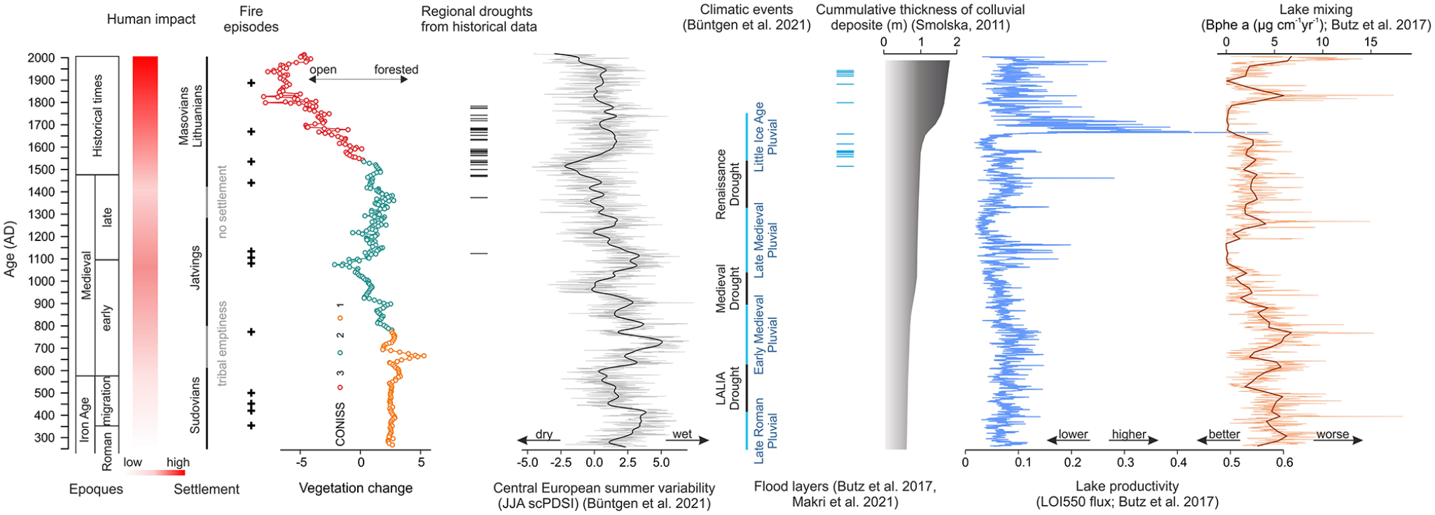
The relationship between human impact, vegetation, climate change, and fire events and their impact on limnological processes.
Fire regimes and fuel availability
The variability of charcoal morphotypes deposited in sediments provides information on the fire’s source and severity (Courtney Mustaphi and Pisaric, 2013; Enache and Cumming, 2006, 2007; Feurdean and Vannière, 2017; Mueller et al., 2019). The distribution of charcoal morphotypes is lake-specific, but their characteristics can reveal taphonomic processes (Enache and Cumming, 2007). Although the morphotypes analysis would suggest that most of the fires in the Suwałki region were low-intensity events, a few of them could have reached the tree crowns. Overall, during low-intensity fires, there is relatively more charcoal production than during high-intensity crown fires (Whitlock et al., 2003). Thus, the CHARs and charcoal morphotypes in Lake Jaczno suggest the presence of both low-intensity surface fires and high-intensity crown fires, with the latter occurring less frequently. In the section below we made an attempt to interpret our data in terms of different types of fire but this description can be biased due to lack of direct measures of fire intensity. The interpretation is based on available keys (Enache and Cumming, 2006; Jensen et al., 2007; Mustaphi and Pisaric, 2014) and the results of experimental studies (Feurdean, 2021). The combination of punky wood, wood, graminoid fragments, and leaves within the first and the second periods (AD 250–1050; Figure 3) relates to surface cool and hot fires most likely with the possible transition to crown fires, as small vegetation change was observed at that time (Figure 4). The third period (AD 1050–1200) characterized by the highest charcoal production and mixed source of fuel (Figure 3) can be linked to fire spread from surface cool fires to crown hot fires. This can be further supported by vegetation change at this time and high human activity in the area (Figure 4). MAC300 and MAC500 were most abundant in this period, which suggest that the fires occurred within the direct vicinity of the lake. Low charcoal accumulation between AD 1200 and AD 1452 suggests no fire at that time. Charcoal particles occurring occasionally could rather suggest a secondary charcoal delivery than actual fires. The last two periods, covering the time between AD 1452 and AD 2011, show similar, high charcoal productivity. The fuel was mixed and consisted of punky wood, grasses, needles, and live wood. The predominance of litter material most likely reflects surface cool fires with the possible spread to undergrowth hot fires, which were most likely related to the slash-and-burn agrarian technique.
The potential flaws in using macrocharcoal types for reconstructing fire intensity have recently been discussed by Vachula et al. (2021). The authors focused on the particles’ length-to-width ratio, but other features should also be taken into consideration. For instance, Feurdean (2021) highlighted that particles subjected to transport may lead to misinterpretation of the data, as charcoals can change their shape or size due to erosion. Therefore, further studies on morphotypes should include more experimental studies as well as an attempt to define charcoal reflectance, which could provide information about the fire intensity.
Fire drivers within the last ca. 1750 years in the Suwałki region
Our study illustrates that there was a clear change in vegetation cover within the study period (Figures 5 and 7). Initially, the arboreal pollen composed up to 95% of the pollen spectra, which is a value similar to the old forest stands nowadays (Baker et al., 2016). The high proportion of shade-tolerant taxa suggests dense forest at the beginning of the period (ca. AD 270 +30/−47); therefore, we assume that the woodland communities reflected the natural vegetation. The emergent layer was composed of Quercus, Tilia cordata, and Ulmus, while the lower canopy was Carpinus betulus. The understory was formed mainly by Corylus avellana.
The first evidence of human impact on the landscape is related to the Sudovians, who colonized the area of the present-day Suwałki region in the early third century. They are known for their burrow mounds (Bliujienė, 2016). The Sudovians’ economy was based on both cultivation and animal husbandry (Pędziszewska et al., 2020), but they may have also burned undergrowth because using fire as a land management tool was known much earlier (Bowman et al., 2009). Thus, the first fires in the vicinity of Lake Jaczno could have been set by Sudovian farmers, but their impact on the environment was rather low. More likely, fires had a natural origin (i.e. lightning strikes) and were related to the Late Antique Little Ice Age (LALIA, Figure 7) – a period of prolonged aridity (Büntgen et al., 2021). Both fires detected in this period, in AD 353 +30/−47 and 500 +29/−47, coincided with the decrease in ruderals and meadow taxa suggesting surface fires with possible transition to crown fire, since a small decrease in the fire-prone Pinus sylvestris occurred shortly thereafter. Dry conditions during LALIA could have also favored biomass ignition within a short distance from the lake ca. AD 773 +28/−46. The fire coincided with a decline in Betula alba and a slight increase in non-arboreal pollen percentage, forest opening, and minor human impact. Corylus avellana typically colonizes early and spreads quickly after fires (Delarze et al., 1992). In our study, a slight increase in hazel was noted before the fire event, at ca. AD 750, but this discrepancy could have been caused by slightly different chronologies and dating uncertainty between the two lakes, Jaczno and Szurpiły.
Within the next decades (from ca. AD 750 to ca. AD 850), climate oscillations undoubtedly impacted the vegetation history and fire occurrence in Lake Jaczno’s surroundings. For instance, the sharp decline in Alnus contribution during the Medieval Warm Anomaly (ca. AD 800) has been widely discussed (Latałowa et al., 2019; Stivrins et al., 2017). The reason was probably a combination of several environmental factors, such as rapid climatic extremes (severe drought), hydrological instability, and pathogen outbreak. After the alder population collapsed, the wet/moist soils closer to the lake were overgrown by birches and willow shrubs, whereas poplar grew on dry raw soils.
An unstable settlement or even land abandonment (tribal emptiness) near Lake Jaczno persisted to the mid-9th century, when a synchronous decrease in birch and an increasing abundance of shade-tolerant taxa (Alnus) caused the forest canopy to become denser, at least locally. Shortly afterward, anthropogenic vegetation became more pronounced. This increase was undoubtedly related to the higher activity of the Jatvings, who arrived in the Suwałki Lakeland in the 9th century. Their economy was based mainly on agriculture, animal husbandry, and fishing (Kinder et al., 2019). However, the largest forest clearance took place between AD 1000 +28/−41 and 1100 +28/−38, so fires that occurred during that time were strictly related to the Jatvings’ activity. Their presence in the Suwałki Lakeland caused more frequent biomass burning. The events in AD 1081 +28/−38 and/or AD 1088 +28/−38 were high-intensity fires (possibly crown fires), as suggested by rapid land opening. The next two fire events in AD 1109 +28/−38 and 1137 +27/−38 likely also reached the crowns, which is suggested by the mixture of fuel with a high contribution of leaves and living wood particles. On the other hand, the forest canopy became denser at that time, which could have been in contradiction with the fires’ severity. This discrepancy could have been caused by the fast spread of birch shrubs and forests, which is shown by the high percentage of Betula alba t. Fires and abundant birch were also observed in the vicinity of Lake Żabińskie between AD 1065 and 1290 (Wacnik et al. 2016). They were related to a clearing of the land for cultivation and resulted in ash fertilizing the soils. Similarly, a slash-and-burn agriculture technique was used near the lakes Miłkowskie and Wojnowo, resulting in secondary succession of vegetation, which developed rapidly on no longer productive farmlands (Wacnik et al., 2014).
Until the second half of the 13th century, there was a continuous settlement in the area of Lake Jaczno, but the human impact was significantly lower. As a result of the so-called Holy Wars, in AD 1283, the Jatvings were conquered and their influence in the area ceased (Kinder et al., 2019; Marcisz et al., 2020; Wiśniewski, 1965).
Thereafter, forests in the area regenerated. The expansion of birch occurred first and was followed by pine and other trees. The expansion of Picea abies was slow but steady on the land exploited and abandoned by the local population; it reflected the development of forests with spruce, which is synchronous with other sites in northeast Poland (Wacnik et al., 2016). According to our pollen data, the Lithuanians/Masovians started to colonize the region in ca. AD 1440 +25/−34, but their pressure on the environment was low. Although their economy was based on hunting, beekeeping, and hay production (Wiśniewski, 1965), Gałka et al. (2014) suggested that local farming, tar production, and forestry were also vital for the society’s development. Forestry became especially important from the 15th century onward due to the demand for timber in Europe (Haneca et al., 2005). The major land cover change from wooded to open landscape took place at ca. AD 1500 +24/−33 and the process of transformation lasted for approx. 30 years (Figure 7).
The bidirectional relationship between the tree cover and the local climate has been investigated by several authors and summarized by Feurdean et al. (2020), who indicated that the tree cover is a first-order fire predictor regardless of the fire driver. Thus, a dense forest canopy will produce a moist, low-flammability microclimate, while a reduction in tree cover provides a fuel composed of herbs, shrubs, and woody debris, which favors ignition, surface fire spread, and in some cases, the transition from surface to crown fires (Feurdean et al., 2020; Fréjaville et al., 2016; Pausas and Paula, 2012). This relationship is especially evident in our record between ca. AD 950 +28/−42 and 1050 +28/−39, when there was an increase in shade-tolerant Alnus, which could have created moist conditions near the surface and naturally suppressed fires. The further land opening and establishment of fields and meadows along with dryer climate conditions could have induced a wildfire, for instance in ca. AD 1536 +24/−33.
The oldest reference to two villages located in the research area, Ługiele and Smolniki (Figure 1b), comes from AD 1642 (Wiśniewski, 1965). Thus, we assume that the fire dated to AD 1662 +21/−30 was related to villages being formed, the land being transformed into arable areas, and forests being exploited in the Suwałki region. The Swedish deluge (AD 1655–1660), plague, and exceptionally severe climatic conditions during the Little Ice Age reduced food production and caused famine. It is ambiguous whether these phenomena had a significant influence on the local vegetation, as at that time lumberjacks, ash-makers, and tar-makers were highly active, reducing the forest cover because charcoal was a common fuel across Europe in the pre-industrial times (Raab et al., 2015). Some of the most efficient charcoal came from Carpinus sp., Quercus sp., Picea sp., and Alnus sp., with an estimated percentage of production efficiency as high as 100%, 84%, 75%, and 59%, respectively (Samojlik et al., 2013 and references therein). Pinus sp. was the material best suited for wood-tar production (Czopek, 1997).
Although not investigated on a large scale, fire likelihood and severity can be increased by insect outbreaks (Rogers et al., 2020) because changing fuel conditions through, for example, defoliation negatively affects timber and fiber production or changes the tree water budget (Schafstall et al., 2020). Beetle-induced changes to foliar moisture have the greatest effects on flammability (Fettig et al., 2021). The fire event at ca. AD 1893 +13/−6 was probably human-induced, but we assume that the invasion of bark beetles and black arches in East Prussia (currently northeast Poland) between AD 1853 and 1862 (Kinder et al., 2019) could have had some influence on fuel availability.
From the mid-19th century to the second half of the 20th century, the area was intensely deforested; in ca. AD 1938 the course of Lake Jaczno’s inlet in the north was changed (Poraj-Górska et al., 2017). After AD 1970, there was a regeneration of forest cover with light-demanding, fast-growing pioneer species such as Betula alba and Carpinus betulus expanding. The lower fire activity and frequency in the last 100 years or less are related to the development of fire suppression strategies (Dietze et al., 2019; Słowiński et al., 2019).
Implications for limnological processes
It has been shown that fire influences ecosystems by changing soil properties (Alcañiz et al., 2018) and stability, modifying infiltration, and promoting soil erosion (Haliuc et al., 2016), which lead to changes in nutrient storage and losses from forest ecosystems (Schlesinger et al., 2016). For instance, the post-fire nutrient release in the watershed of Gold Creek Lake (Colorado, USA; Dunnette et al., 2014) increased lake productivity. That increase was relatively brief and lasted for approx. 20 years, but this period varies among lakes (Pompeani et al., 2020).
The relationship between organic matter content (LOI550 flux), and CHAR from Lake Jaczno, (Figures 6 and 7) shows an increase in organic matter deposition after fire events, but as expected, this relationship is not very strong. The discrepancies are most likely caused by different sampling resolutions (7 years on average for CHAR and annually for LOI550). Butz et al. (2017) showed that most of the organic matter deposited in Lake Jaczno is of an autochthonous origin, yet some of it originated from the catchment inputs, which obviously lowers the strength of similarity between LOI550 and CHAR. Despite these pitfalls, it seems evident that each fire event was accompanied by an increase in lake productivity lasting up to several decades (Figure 7). Interestingly, the highest increase in lake productivity was observed after the fire in ca. AD 1662 +21/−30, which coincides with drought, a fire event, and a flood layer in the sediment profile. Heavy rains, floods, and heavier land transformation increase weathering intensity and alter lake productivity through nutrient delivery (Bonk et al., 2016; Bork and Lang, 2003; Czymzik et al., 2013). The combination of surface relief, deforestation (opening of the landscape), and heavy rainfalls (Oliński, unpublished data) generated slope processes. Thus, the flood layers described by Butz et al. (2017) and Makri et al. (2021) may be the result of heavy rains following a few dry months. Furthermore, this period saw an increasing human impact on the environment (Figures 4 and 7). Smolska (2011) reconstructed the cumulative thickness of colluvial deposits for the Suwałki Lakeland (Figure 7), showing increasing agricultural land use around that time.
Our data show that fires, human activity, and climate influenced the vegetation cover in the vicinity of Lake Jaczno. The most prominent changes were related to the land being cleared, which implies changes in water column mixing (Figure 7; Butz et al., 2017). It seems that before the first intense forest clearance initiated by the Jatvings, Lake Jaczno was naturally meromictic (Butz et al., 2017), but the forest clearance between AD 1000–1100 and later, especially ca. AD 1650 and AD 1890, caused better water mixing and flickering through the dimixis threshold.
Conclusions
In this study, we sought to investigate the interactions between changing climatic conditions, vegetation, fires, and human activity, as well as to examine how fire events affect limnological processes. We performed macrocharcoal analysis from the varved Lake Jaczno and combined it with pollen data from the varved Lake Szurpiły, both located in the European Lowland (northeast Poland). Our findings were further supported by historical data and statistical analysis.
The macrocharcoal morphotype analysis suggests that both low- and high-intensity fires occurred in the study area, but this interpretation should be treated with caution. Undoubtedly, humans have changed fuel availability and have altered biomass burning. Having more frequent fire episodes is in line with denser populations and human-induced land cover transformations from forested areas to arable lands. The low fire frequency (approx. 2.5 fires 500 yr−1) corresponded to the tribal emptiness between the 7th and the 9th century, while high values (up to 7 fires 500 yr−1) were observed in periods of increased human activity in the region. Fire must have been used as a land management tool for improved grazing, but also for slash-and-burn crop cultivation. However, some of the fires may have had a natural origin, as they occurred when the human impact was limited or when there were droughts in the region.
Our data show that the fire in the catchment influenced the limnological processes in Lake Jaczno by increasing organic matter production. This is related to increased erosion and enhanced nutrient delivery due most likely to the land transformation. The charred particles could have acted as fertilizers themselves, but they also made the soil more vulnerable to erosion. It is also evident that fire events and the related forest clearing influenced the water column mixing and led to a change from natural meromixis to the dimixis threshold.
Footnotes
Acknowledgements
We would like to thank Dr. Christoph Butz for providing the Jake Jaczno chronology, LOI550 flux measurements, and fruitful discussions. Special thanks go to Dr. Joanna Piłczyńska for her help in preparing the macrocharcoal samples and Dr. Małgorzata Kinder for sharing age-depth model for Lake Szurpiły.
Authors’ contribution
AB and MS designed this study. AB and WT did the fieldwork. AB performed the macrocharcoal analysis. MF and MK counted the pollen. PO collected the historical data. MŻ performed the statistical analysis. AB and MŻ prepared the figures and table. AB wrote the majority of the paper, but all other authors contributed to writing some sections. All authors contributed to discussions and text corrections.
Funding
The author(s) disclosed receipt of the following financial support for the research, authorship, and/or publication of this article: This study is a contribution to a scientific project financed by the National Science Centre, Poland – No. 2019/32/C/ST10/00038.