
Abstract
This paper documents the Late-Holocene environmental changes and human presence in the northern Danube delta using a multidisciplinary approach that combines geoscientific data with archaeological findings, historical texts, and maps. It follows the formation and progression of the Chilia distributary and the reconfiguration of socioeconomic activities. Sedimentary facies identified on five new cores by changes in texture properties, magnetic susceptibility, geochemistry, and macro- and microfauna composition together with the newly obtained chronology constrain the complex evolution of the Chilia branch as filling in a long-lasting bay and then of a giant lagoon (Thiagola) which covered most of the northern delta since the Old Danube lobe inception (ca. 7500 yrs BP) till modern Chilia development. It initiated during the Greek Antiquity (ca. 2500 yrs ar BP) at the delta apex, while in Roman times (ca. 1800 yrs BP) it pursued its slow flowing into the vast Thiagola Lagoon. The most dramatic transformations occurred in the last 800 years when the river passed east of the Chilia promontory, rapidly went through the present-day Matița-Merhei basin (several decades), and created its first open-sea outlet. Solid discharge increased in two distinct periods, once in the Middle Ages (ca. 750 yrs BP) and then in the Modern Period (ca. 150 yrs BP) due to human-induced land-use changes in the Danube watershed. The chronology of the cultural remains on the pre-deltaic Chilia promontory and the multiproxy analysis of a sediment core retrieved nearby downstream suggest the terrestrial connection of the island with the mainland in ancient times. The hitherto contended issue of the old Thiagola Lagoon and its location are redefined here, as are the original identifications of ancient and medieval toponyms and hydronyms, especially for Chilia-Licostomo, Byzantine, Genoese, Moldavian, Ottoman, and Russian trading point of great importance in the political and economic history of the Black Sea and neighboring regions.
Introduction
The lower Danube has always been one of the main circulation and habitation axes (Chu, 2018; Ioviță et al., 2014) but also the frontier between the Mediterranean zone and the Eurasiatic steppe (Dan, 2011 on Herodotus 2.33-34, 4.47-50). Deltaic system development naturally pushed this frame northward. During Roman Times, the southern arm (largely corresponding to the present-day Sf. Gheorghe) represented the north-eastern limit of the Empire. Further, ca. 950 AD, Sulina distributary was perceived by the Byzantine emperor Constantine Porphyrogenitus as the boundary between Bulgaria and the Pechenegs, while in the 13th and 14th centuries AD the Byzantines and the Genoese settled along the Chilia arm. In the 15th century AD, the Ottomans overcame other regional competitors and brought this prosperous navigable channel under their control. It became anew a border in the 19th century AD between the Russians and the Ottomans. Today it is part of the Eastern frontier of the European Union.
The Chilia distributary, characterized by three large, bifurcating channel systems in the Pardina and Matița–Merhei depressions, and east of Letea beach ridge plain ultimately built the northern part of the Danube delta between Sulina arm (S) and Budgeak Plateau (N) (Figure 1). Most of the research on the Chilia distributary either treated it secondarily in works dealing with the whole deltaic system (Zenkovich, 1956; Panin, 1983, 2003; Giosan et al., 2006; Vespremeanu-Stroe et al., 2017) or focused solely on its secondary delta (the open coast lobe) as its flashing dynamics was registered by accurate cartographic documents from 1771 onwards (Mikhailova and Levashova, 2001; Vespremeanu, 1984). Panin (1983, 2003) developed the former theory of Zenkovich (1956), proposing that Chilia initiated as a separate distributary 3500–3000 yrs BP and broke the initial spit (Jibrieni-Letea-Caraorman) ca. 2500 yrs BP while Mikhailova and Levashova (2001) and Filip and Giosan (2014) consider the open-coast lobe of Chilia is younger and was initiated in the last 300 years. Though most of the researchers locate the course of the Chilia arm in the proximity of the Budgeak plateau, Carozza et al. (2013) propose the scenario in which one of its secondary courses might have been flowing south of the Stipoc lacustrine ridge. Only recently, Filip and Giosan (2014) proposed a chronology and a morphodynamic pattern integrating three successive deltaic lobes built throughout two evolutionary phases. Vespremeanau-Stroe et al. (2017) partially challenge this theory. The state of the art of the northern delta evolution reveals the lack of consensus regarding the chronological framework and its evolutionary pattern.
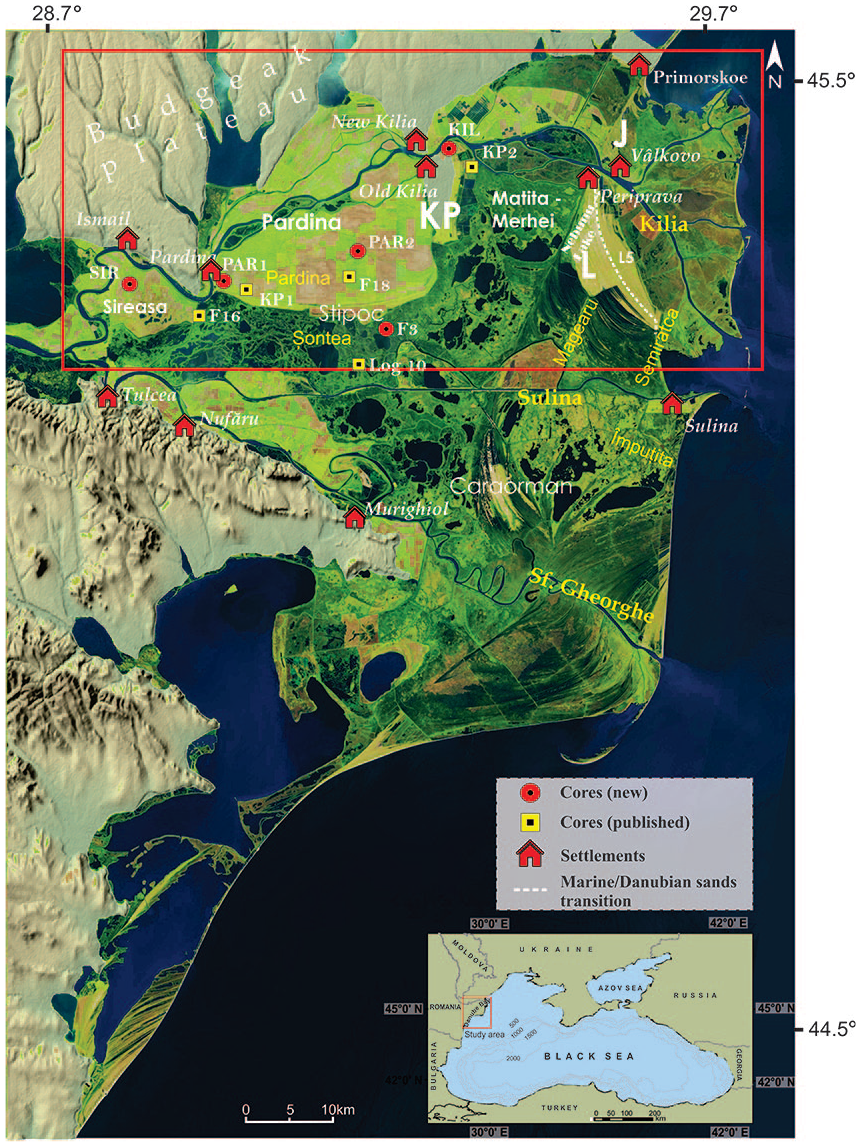
Chilia distributary in the context of the wider Danube delta (framed by the red box). The letters J, L, and C in magenta color indicate the position of the Jibrieni, Letea, and Caraorman beach ridge plains in the Danube delta. KP depicts the Chilia (loess) promontory. Stipoc is the name of the lacustrine ridge plain formed to the south of the Pardina sub-basin. The positions of the new cores Sir, Par1, Par2, Kil, and F3 are indicated by red circles. Previously published cores (Log 10 in Carozza et al., 2013; KP1 and KP2 in Filip and Giosan, 2014; F16 and F18 in Vespremeanu-Stroe et al., 2017) are indicated by yellow squares. The dashed line with the L5 mark (Vespremeanu-Stroe et al., 2016) indicates the boundary between longshore and fluvial borne sediments.
Our paleogeographic reconstruction of the Chilia distributary aims to elucidate the still debatable chronology and the pattern of its development, and the impact it had on the socio-economic activity in the delta. Our study relies on the multi-proxy analysis of five new sediment cores from the right side (Romanian) of the Chilia arm, which contribute with new data to the chronology and environmental transformation along the Chilia branch, thus refining the previous scenarios of the delta evolution. This research offers new insights into the Late-Holocene ecological and socioeconomic transformations in the Danube delta. The ancient, medieval, and early modern texts and maps of different languages are also used in reconstructing the configuration of the delta. This leads to the formulation of a new hypothesis on the identification of several long-debated hydronyms and toponyms (e.g. Psilon, Thiagola, Licostomo, Chilia).
Methods
The paper compares geomorphological, sedimentological, geochemical, and microfauna data on the one hand, and historical and archaeological sources on the other (cf. Brückner, 2020). Each series of data was analyzed according to the methodology of its discipline. Five new sediment cores (SIR, PAR 1, PAR2, KIL, and F3 of 8, 10, 4.5, 4, and 5 m long respectively) were collected using a percussion corer system (Eijkelkamp Cobra TT) and topographically positioned using Leica DGPS (Figure 1); they were analyzed in the context of five previously published cores: Log10 (in Carozza et al., 2013), KP1 and KP2 (in Filip and Giosan, 2014), and F16and F18 (in Vespremeanu-Stroe et al., 2017) (Figures 1 and 2).
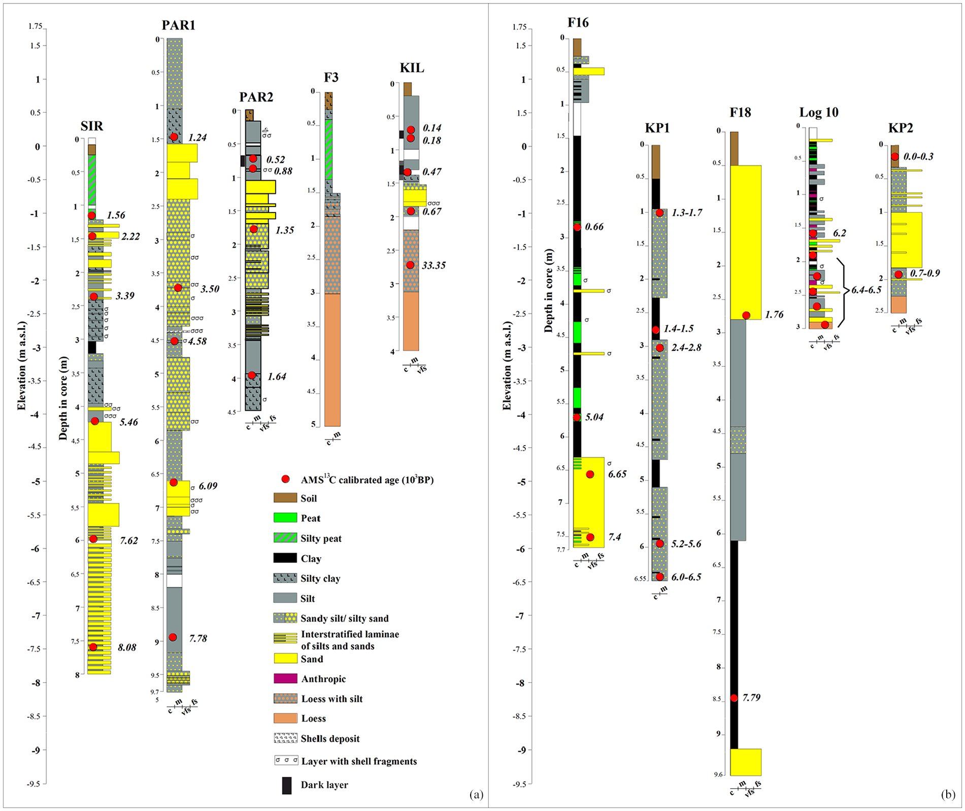
Chronostratigraphic description of the new cores Sir, Par1, Par2, F3, and Kil as well as the previously published cores Log 10 (Carozza et al., 2013), KP1 and KP2 (Filip and Giosan, 2014), and F16 and F18 (Vespremeanu-Stroe et al., 2017).
Magnetic susceptibility measurements
Magnetic susceptibility (MS) measurements were performed every 2 cm on a half split-core covered with thin plastic folia using a Bartington MS3 magnetic susceptibility meter and an MS2K Surface Sensor. The sensor has a 25.4 mm diameter area of response, a depth of response of less than 10 mm, and a maximum resolution of 2 × 10⁻⁶ SI. For each measurement point, we used a measurement period of 10 s and drift correction.
Sediment texture analysis
Sediment samples for grain-size analysis and loss on ignition (LOI) were taken every 10 cm and for each visible sediment texture change. After removing the organic matter with acetic acid (30%) and hydrogen peroxide (10%), the samples were washed with distilled water and treated with 1% sodium polyphosphate solution to prevent fine particle flocculation. The grain size was measured with a Laser Diffraction Particle Size Analyzer LA-960 – HORIBA. The texture was classified according to Folk and Ward (1957) typology as implemented in GRADISTAT 8.0 (Blott and Pye, 2001).
Loss on ignition
After drying the samples for 24 h at room temperature, ca. 3 g of sediment were combusted (in the oven Caloris L 1003) in three successive steps: at 105°C for 24 h, at 550°C for 6 h, and at 950°C for 2 h. After each drying session, the samples were weighed with an accuracy of 10−4 g. The percentage of organic matter and inorganic carbon in each sample was determined by applying the formula of Heiri (2001).
XRF analysis
Elemental determinations were performed using energy dispersive X-ray fluorescence (ED-XRF) to gain insight into the mineralogic composition of the sediments. Analyses were performed using a portable Bruker Tracer S1 Titan spectrometer, that generated an 8-mm-diameter spot with an energy level limited to 40 keV on the selected samples every 10 cm below 40 cm depth. To minimize any errors associated with grain-sized-dependent geochemical characteristics, up to 10 g of material from each depth was collected and reduced mechanically. The material was homogenized, and an aliquot of 2 g was compressed into a pellet using a 25-ton automatic hydraulic press (Specac). The resulting pellets were placed into a plastic holder until analysis. A randomly selected point was analyzed on each sample and exposed to the beam for 60 s. Each characteristic spectrum was later analyzed to obtain elemental concentrations. The results obtained are expressed in parts-per-million (ppm).
The elemental concentration ratios were used a semi-quantitative tool to discriminate between stratigraphic sequences. Elemental concentrations were used to compute ratios between relevant elements for paleoenvironmental reconstructions such as: Ca/Fe relevant for disentangling detrital carbonates and terrestrial Fe input (Nizou et al., 2010; Peck et al., 2007); Zr/Rb indicative for depositional environment energy, hence often used as a proxy for grain size (Hadler et al., 2018), Si/S which discriminates between terrestrial input and anoxic, water-soaked environment.
Microfauna
The microfaunal study was based on 22 micropaleontological samples collected from the KIL core (Figure 1). Each sample weighed about 100 g. All samples were washed and passed through a sieve with 63 μm mesh size following a standard micropalaeontological approach (Stoica et al., 2013).
Absolute dating
Radiocarbon dating by accelerator mass spectrometry (AMS) was conducted at Ro-AMS laboratory at Horia Hulubei National Institute for Physics and Nuclear Engineering, Romania.
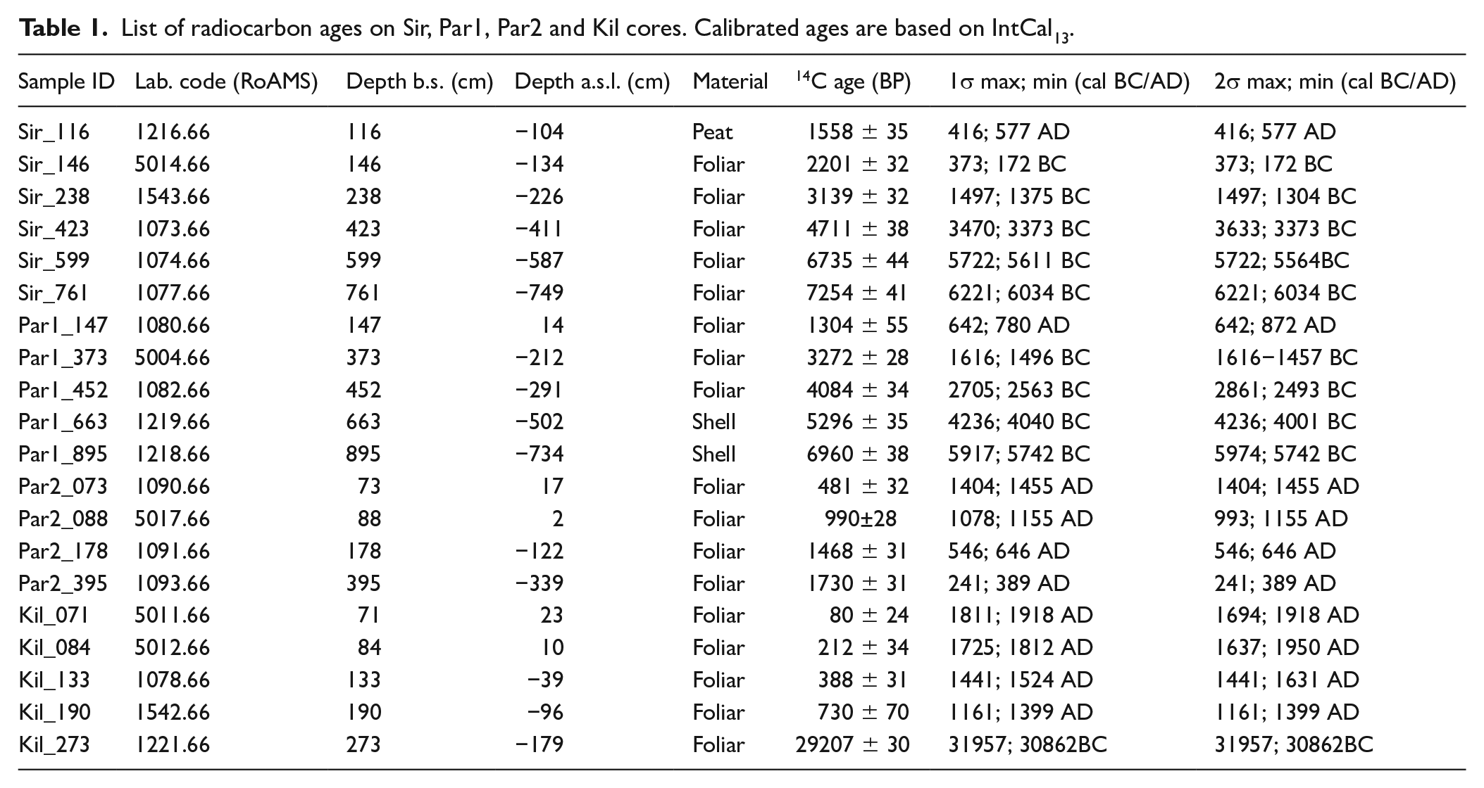
The samples with organic materials and shells were pre-treated according to the method of Sava et al. (2019). Conventional radiocarbon ages were normalized relative to the international standard (NIST SRM 4990C) Oxalic Acid II, so that 74.59% of the activity represents the reference of the modern 14C activity. Measured radiocarbon ages were corrected for blank level and isotopic fractionation using δ13C, which was compared with the VPDB standard. The ages were finally calibrated using OxCal online V 4.4 (Ramsey, 1995) and IntCal13 atmospheric curve (Reimer et al., 2013). The chronological references are expressed as years BP (1950) along with the calibrated age intervals for the ages obtained by radiocarbon dating (Table 1) and years ago for optically stimulated luminescence (OSL) ages (Table 2). The samples dated by OSL were collected between 2014 and 2018. The ka formulation is used to express the reference to 2018.
List of radiocarbon ages on Sir, Par1, Par2 and Kil cores. Calibrated ages are based on IntCal13.
Ages based on Optical Stimulated Luminescence (OSL).
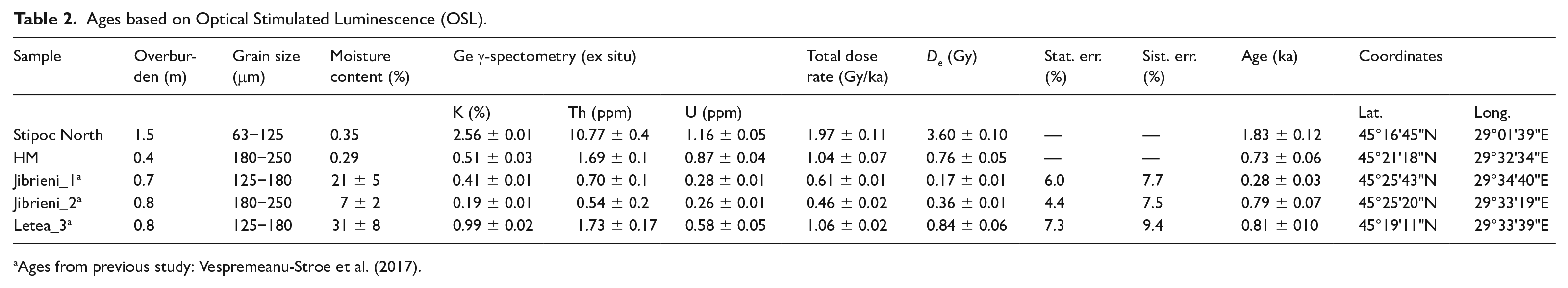
Ages from previous study: Vespremeanu-Stroe et al. (2017).
OSL dating was performed at the Luminescence and Gamma Spectrometry Laboratory (LEGaL), Institute of Geosciences of the University of São Paulo (USP). After the 180–250 µm grain-size fraction was isolated and organic matter, carbonates, heavy minerals, and feldspars were removed following standard procedures (Pupim et al., 2017) the single aliquot regenerative dose (SAR) protocol (Murray and Wintle, 2000, 2003) was applied to estimate the radiation equivalent doses (Table 2). The beta and gamma radiation dose rates were determined using the radionuclides concentrations (U, Th. and K) and conversion factors suggested by Guérin et al. (2011).
Archaeological traces
Although human presence is attested along the lower Danube valley since Palaeolithic (Borziac, 1995; Păunescu, 1999), archaeological finds are problematic and rather poorly studied in the northern delta (Micu et al., 2016) largely due to the deltaic system dynamics and the inherent communication difficulties associated with the borderline between Romania, Moldavia, and Ukraine. We have collected and discussed the whole evidence, checked the finds and the discovery spots during, and provide here a critical synthesis. In the Romanian part of the northern Danube delta, itinerant archaeological surveys are conducted from the 1970s (Micu et al., 2011, 2016; Simion, 1971; https://map.cimec.ro/Mapserver/) and excavations have been undertaken on the late Chalcolithic Taraschina tell settlement (near Mila 23) (Carozza et al., 2011, 2012, 2013) and Dâmbul lui Haralambie (Mihail et al., 2014) emplaced on pre-deltaic loess between Chilia and Sulina arms. Across the Chilia lobes, the earliest inhumations date back to the Early Bronze Age in tumuli from Chilia loess promontory which also contain secondary inhumations traces from the Late Bronze Age, Antiquity, and Early Middle Age (Motzoi-Chicideanu, 2011; Vasiliu, 1995). Fragments of shipwrecks, coins, and sherds of various periods have been recorded and partially excavated on the Tătaru and Chilia channels, the Chilia Promontory, and on the Letea ridge plain near Periprava (Mănucu-Adameșteanu, 2020; Micu et al., 2016).
In Ukraine, apart from the new excavations in Kartal (between Reni and Izmail, Bruiako and Agul’nikov, 2017; Bruyako et al., 2005-2009), some general histories (Dergaciov, 2010; Rajnov, 2008-2011; Şlapac, 2004, 2008), most of the archaeological heritage remains unpublished. Heterogeneous collections of ancient, Byzantine and medieval objects are held in the museums of (New) Chilia and Vylkove.
Historical texts and maps
Ancient, medieval, and modern texts and maps are available in their original Greek, Latin, Italian and Ottoman manuscripts, compendia, and atlases (like Atlas, 2008, 2011; Gordieiev, 2015; Gordyeyev, 2007; Popescu-Spineni, 1978) but there was no comprehensive study about their making, nor any critical attempt to locate all their toponyms and hydronyms. We collected them and investigated the cultural context of creation and transmission, in relationship with our new geomorphological reconstructions. We selected the most representative documents for each historical epoch in Figure 3. Despite the rarity of eyewitnesses, the tradition is coherent and allows us to reconstruct different historical toponyms and the regional topography of the northern Danube, which serve as an indispensable basis for the evaluation of the human impact in the evolution of the environment. Anomalies in texts and maps can be explained after identifying the inhabited sites and understanding their economic, political, and military networking patterns over the last six millennia.
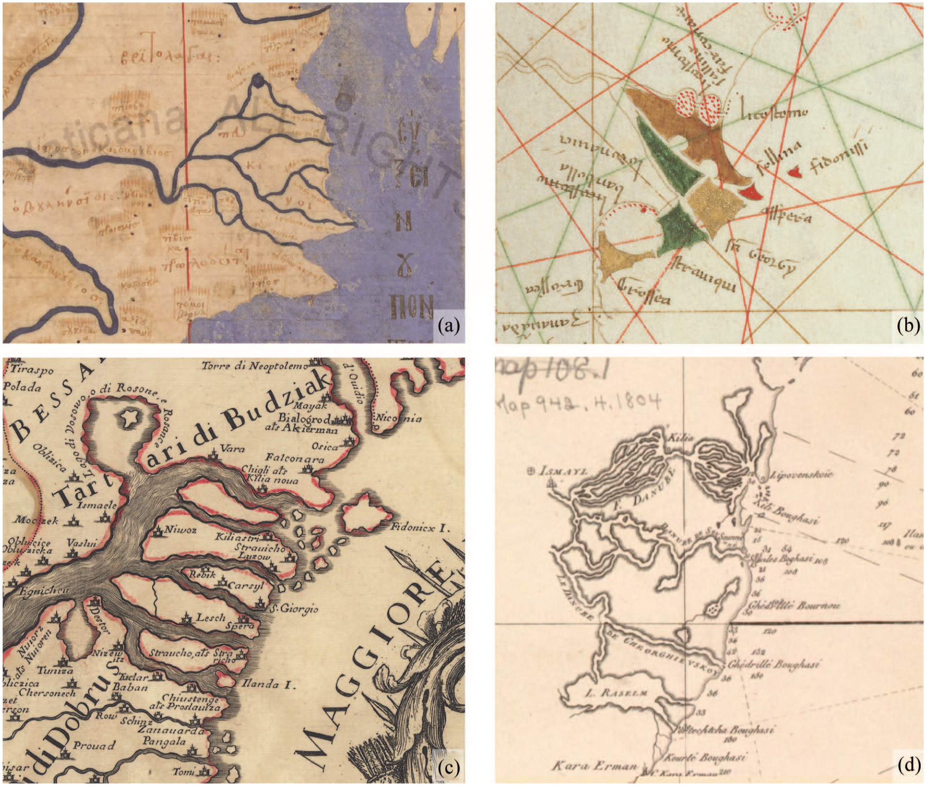
Historical maps depicting the configuration of the Danube delta at various moments. (a) Claudius Ptolemy (ca. 150 AD) (from https://digi.vatlib.it/view/MSS_Urb.gr.82). (b) Petrus Vesconte Portolan (1321) (from https://www.emanuscripta.ch/zuzneb/content/pageview/912762). (c) Description of the Principalities of Moldavia and Wallachia cropped by Giacomo Cantelli da Vignola in 1686 (from https://www.davidrumsey.com/luna/servlet/detail/RUMSEY~8~1~290624~90067214:Descritione-delliPrincipati-della-). (d) Map of the Black Sea, Azov Sea, and Marmara Sea published by A. Wilbrecht in 1804 (from https://www.digitalcommonwealth.org/search/commonwealth:kk91fr32w).
Regional settings
The Chilia branch, currently the Danube’s longest distributary (117 km), originates at the apex of the delta (Ceatal Izmail) where the Danube bifurcates into the Chilia and Tulcea arms. It carries ca. 50% (~3300 m3/s cf. INHGA data) of the Danube’s water discharge. Suspended sediment transport is about three times lower now than before the completion of the Iron Gates I and II dams in the early 1970s (Preoteasa et al., 2016). The Chilia is the youngest distributary of the Danube as most of its floodplain was formed during the last 2000 years according to newly obtained radiocarbon ages. Traveling to the sea, it successively filled up two basins that largely corresponded to the antecedent topography: Pardina basin between Stipoc lacustrine beach ridge plain (BRP) (S), Budgeak plateau (N), and Chilia loess promontory (E); Matița-Merhei basin east of the Chilia promontory, bordered by Letea ridge plain to the east. Finally, the open-coast Chilia secondary delta developed as fluvial dominated seaward of Letea until the mid-20th century after which it gradually acquired a wave-dominated morphology (Figure 1).
Results
Sediment characteristics and chronostratigraphy
Sedimentation from the northern Danube delta was analyzed in terms of the sediment texture (i.e. mean grain size and sorting), organic matter (OM) content, inorganic carbonates (Cinorg), and magnetic susceptibility (MS) measured on the four cores and corroborated with previously published data from cores at proximal locations.
Before entering the Pardina basin and building the first confined deltaic lobe, the Chilia distributary passed through the Sireasa basin and covered it with a thin veneer of sediments just after its diffluence from the main Danube watercourse. The sediment characteristics of the SIR core (N: 45°17″37′.90/E: 28°49″59′.66) feature the advection of predominantly coarse silt and clay particles interbedded with fine sand at the upper part of the core. The core was extracted about 2 km east of the present Chilia channel (Figure 1) with the aim to investigate deltaic stratigraphy in proximity to the bifurcation of the Danube into the Tulcea and Chilia arms. Four main depositional units can be identified here according to significant changes in the sediment texture, OM content, and MS values (Figure 4). At the lower part of the core, from 800 to 400 cm, thin veneers of sand alternate with silt (ca. 1–2 cm thick). MS values are highest between these depths, reaching mean values of 3.10−5 SI with numerous large amplitudes, which probably reflect several detrital pulses. This unit has relatively low OM values (3.2%) and is predominantly inorganic (2.3%) (Figure 4). After a 50 cm layer of bulk sand between 475 and 425 cm, a new sedimentation cycle begins (starting from ca. 5400 yrs BP) with sediments changing to fine silt and clay between 428 and 329 cm. The distribution of OM and Cinorg shows the largest variability along the core, with four peaks disrupting the trend of the organic content at 422, 399, 329, and 239 cm. Noteworthy, the structure of thin veneers (i.e. cm size) of fine sand or coarse silt intertwined with OM laminae reappears from 240 cm until 130 cm. An almost 100 cm layer of peaty mud was found from 120 to 25 cm and capped by soil. MS values are comparatively low with more constant values, whereas mean OM increases to 11.7% and Cinorg decreases to 0.5%.
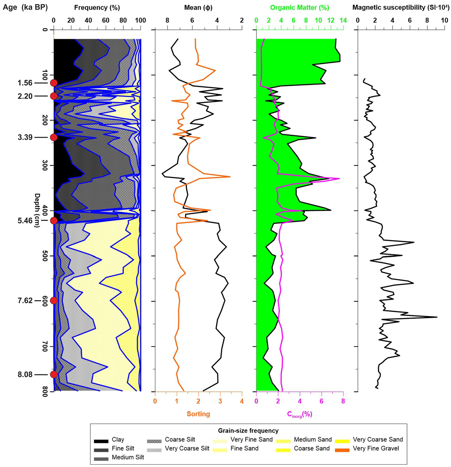
Sireasa core with sediment texture, organic matter content, and MS values.
The PAR 1 (N: 45°17′49.37″/E: 28°58′10.00″) core was retrieved further downstream along the Chilia distributary in the south-western part of Pardina basin (Figure 1). Four radiocarbon ages constrain the chronostratigraphy, which was cross-checked with the ages obtained by Filip and Giosan (2014) at a nearby location. The lowermost unit comprises very fine sand and coarse silt laminae at the base between 975 and 920 cm followed by homogeneous silt layers up to 775 cm (Figure 5). Mean OM (4.5%) and Cinorg (2%) are relatively homogeneous with high values. An upward coarsening from silt to moderately sorted very fine sand is found up to 657 cm accompanied by a rapid drop in the OM content. This sandy unit is overlaid by half a meter of coarse silt (486–437 cm) with large variations in the organic and inorganic carbonate content. These changing depositional conditions occurred about 4500 yrs BP, as indicated by the radiocarbon age obtained at 450 cm depth (Table 1). From 241 to 161 cm, the sedimentation predominantly consists of poorly sorted fine sands with a higher content of Cinorg (1.7%) and a lower OM weight (1.3%). The sediment fraction changes to medium and fine silt along with a rapid increase in the OM content, which reaches the highest values along the entire core (9.4%), indicating the shift to a stagnant water body that was artificially drained in the 20th century. The change from sand to silt deposition was dated to ca. 1200 year BP at 150 cm depth. The MS oscillations are controlled by the changes in lithology.
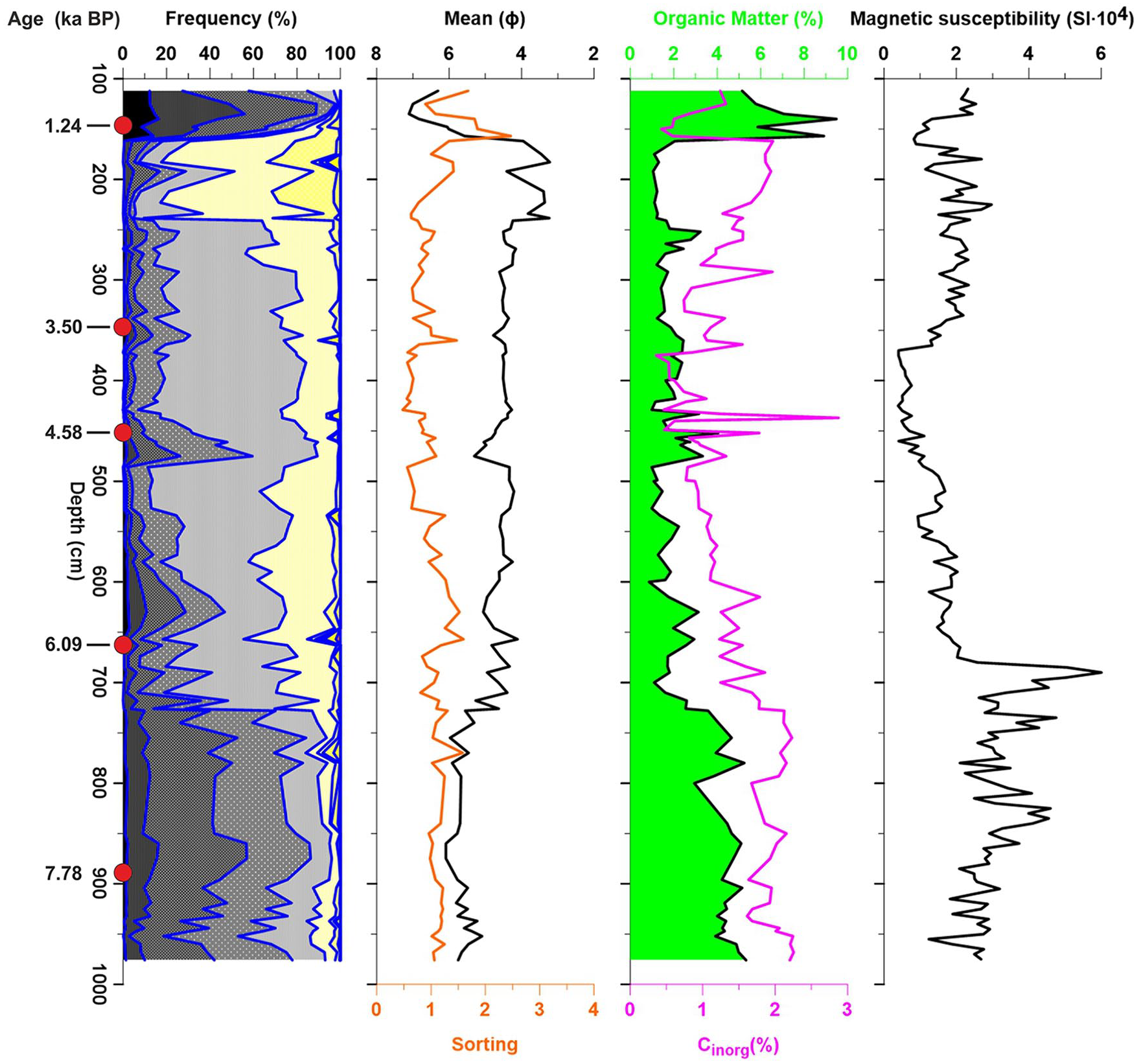
Par1 core with sediment texture, organic matter content, and MS values.
The PAR 2 core (N: 45°19′25.69″/E: 29°10′34.13″) is 450 cm long and located on the right levee of a former secondary channel crossing the Pardina lagoon in the eastward direction (Figure 1). Four depositional sequences can be distinguished (Figure 6). Firstly, a basal layer consisting of coarse to medium silt from 450 to 370 cm was formed in Late Antiquity (1600 yrs BP at 395 cm depth). This sequence is covered by very thin layers of poorly sorted coarse silt alternating with very fine sand layers until ca 200 cm. A piece of wood at a depth of 329 cm was dated to ca 4200 yrs BP (Table 1), indicating the presence of reworked material. The next sediment layer up to 105 cm comprises very fine sand with a spike of fine sand at 170 cm. According to the radiocarbon age obtained at 175 cm, the deposition was active 1300 yrs BP. The next upper layer between 105 to 65 cm is characterized by a very high OM content (6.8%) within a matrix of poorly sorted coarse and medium silt. A distinct change in the sedimentation regime occurred ca. 520 year BP when the fluvial sediment accumulation was replaced by predominantly organic deposition (peat). MS values are constant around 2 × 10⁻⁵ SI, which are similar to data obtained in the upper part of the SIR and PAR 1 cores.
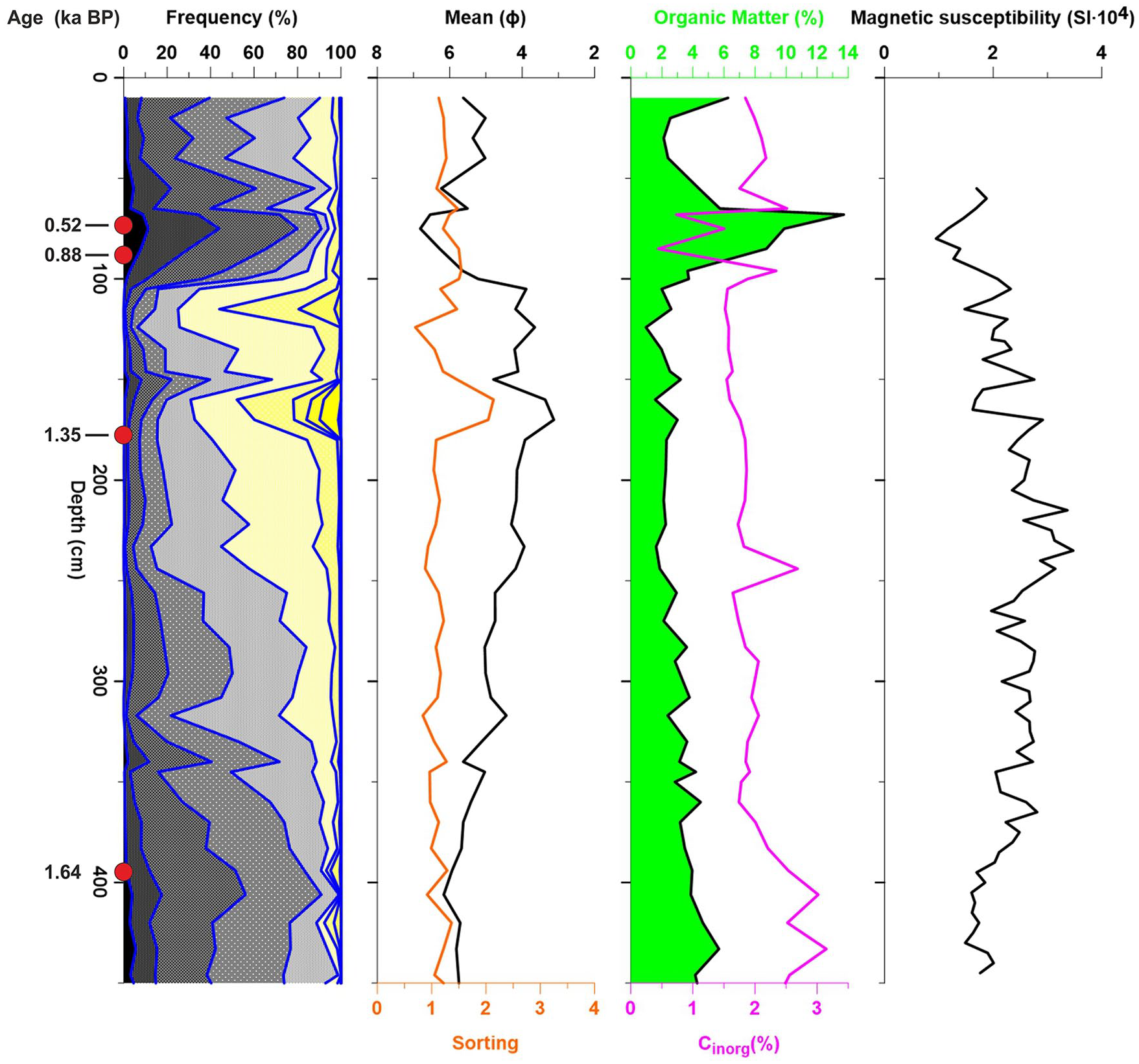
Par2 core with sediment texture, organic matter content, and MS values.
The KIL core (N: 45°26′12.81″/E: 29°19′2.34″) is 400 cm long and taken from the north-eastern part of the Chilia promontory (Figure 1). The core intercepts the pre-deltaic loess deposits at 312 cm depth, which is overlaid by poorly sorted silt up to 180 cm (Figure 7). A sudden increase in the grain size is marked by moderately sorted sediments with very coarse silt and fine sand. Sand sediment accumulation abruptly ceases at 150 cm with the accumulation of finer and poorly sorted sediments. This change in sedimentation regime is also accompanied by an increase in OM content, which peaks at 12% at 130 and 75 cm.
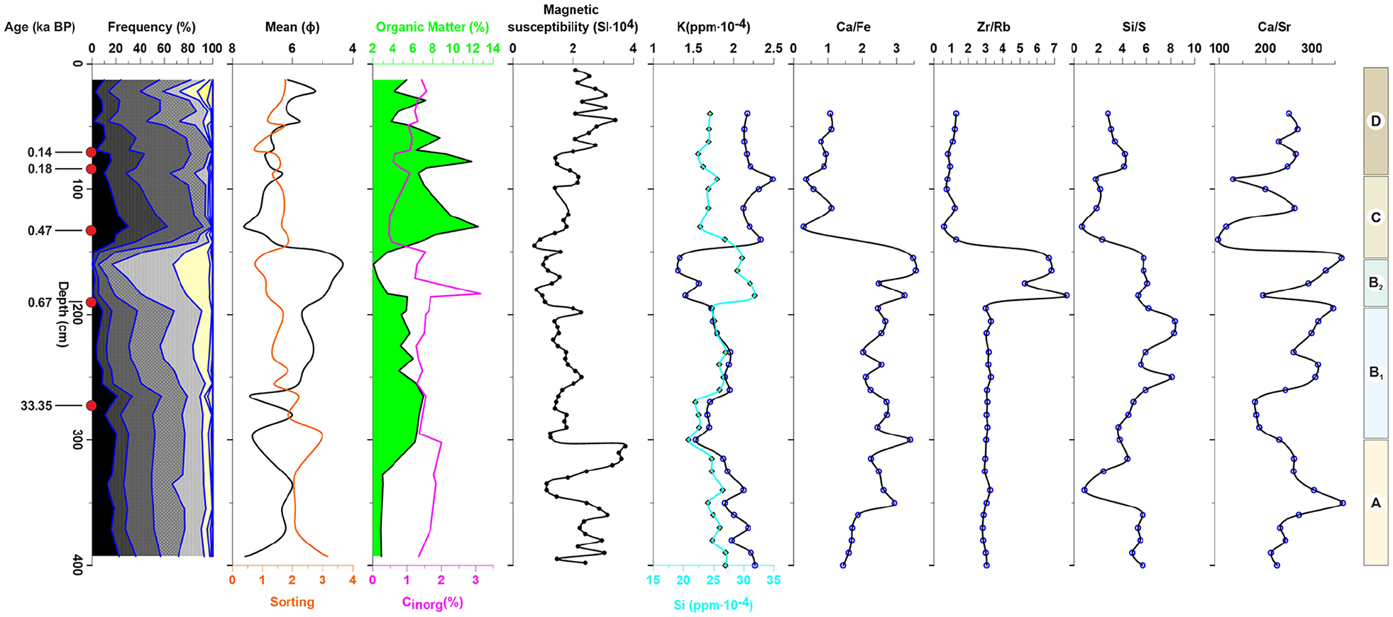
Kil core with sediment texture, organic matter content, MS values, and geochemical properties. The synthesis of these data reveals the succession of the following environments: pre-deltaic loess (Unit A); active shoreface of a marine embayment (Unit B1), lagoon with marine connexion (Unit B2), freshwater lake/wetland (Unit C), drained wetland (Unit D).
F3 core (N: 45°14′35.06″/29°13′0.10″) is 5 m long sampled from 2.5 km south of the eastern half of the Stipoc ridgeplain (Figure 2). It was only described in situ as intercepting loess deposit from 300 to 500 cm, subsequently covered by a 130 cm mixture of silt and loess (from 300 to 170 cm) and clay (from 155 to 140 cm). This fine sediment matrix was then covered by ca. 100 cm of peat (from 140 to 45 cm sealed by 40 cm of clayey soil).
Microfauna inventory
On the KIL core, the first microfaunal evidence appears in the upper levels above the loess deposits (Figure 8). In the silty interval from 300 to 223 cm, microfauna is rare, as it is only found in a few specimens of foraminifera and brackish and freshwater ostracods. Starting at a depth of 180–152 cm, microfauna is much more abundant, represented by numerous specimens of euryhaline foraminifera Ammonia beccari and Porosononion sp., along with brackish ostracods such as Tyrrhenocythere amnicola, Calistocythere diffusa, Amnicythere multipunctata, Amnicythere bendovanica, Loxoconcha sp., Candona schweyeri, Limnocythere inopinata, and the euryhaline species Cyprideis torosa. There are also some freshwater ostracods, mainly Darwinula stevensoni, Ilyocypris gibba, Ilyocypris bradyi, Eucypris dulciformis, Cypridopsis vidua, Pseudocandona compressa, Cypria ophtalmica, Candona neglecta, and Cyclocypris laevis. From the 152 cm level in this core, the upper clay sediments no longer contain foraminifera and brackish ostracods. Only freshwater ostracod can be identified, particularly specimens of I. gibba, I. bradyi, P. compressa, and C. neglecta.

Paleofauna assemblage profile of the Kil core.
Geochemical analysis
Mineralogical determinations on the KIL core show the concurrent variation of K and Si concentrations in the lower part of the core (up to 195 cm) and their antagonistic upcore pattern followed by a switch toward a higher K content associated with a finer sediment fraction at the top of the core (Figure 7).
The Zr/Rb ratio as the erosion proxy is especially important, as it highlights the succession of different energetic environments. The large values of this ratio between 180 and 150 cm indicate more energetic depositional conditions, which is supported by the coarser sediment size at this depth. The Ca/Fe distribution along the core might be related to carbonates precipitation in the lower 50 cm of the core, whereas loess has been intercepted, whereas the upcore increase until 150 cm depth must be related to the lagoon water carbonate detritus content. The lower values of the top layer might be ascribed to the change toward a progressively drained and dryer terrestrial environment. The Si/S ratio varies greatly along the core, with high values combined with episodes of sediment advection at depths of 315 and 155 cm, and lower values indicative of stagnant water regimes at 350, 130, and 92 cm (Figure 7).
Archaeological and historical data
Before the inception of the Chilia distributary, a network of late Neolithic and Chalcolithic sites (Hamangia, Boian, and Gumelniţa cultures) are identified on the loess terraces framing the delta as well as on the pre-deltaic loess within the delta, near our study area in-between Stipoc ridge and Sulina branch at Taraschina and Dâmbu lui Haralambie sites, where traces of inhabitation since ca. 6750 yrs BP with a peak during 6550–6050 yrs BP, subsequently re-used during the Roman and Medieval time have been reported (Carozza et al., 2012, 2013; Micu et al., 2009; Mihail et al., 2014). After the inundation of ca. 6500–6000 yrs BP and the progradation of the Old Danube lobe, the loess mounds which remained isolated from the mainland as well as the new built deltaic land capping the pre-deltaic loess (e.g. Stipoc lacustrine ridge) have only scattered traces of habitation, during the Bronze Age (ca. 5000–4000 yrs BP), (and after an unexplained discontinuity during the early Iron Age), in La Tène/Greco-Roman (ca. 2400–1400 yrs BP).
On the continental left-hand side of the distributary, from Chalcolithic to Bronze Age onwards, small communities of nomadic and seminomadic cattle breeders and fishers occupied the loess terraces of the Budgeak plateau to the N of the delta (Ancient Cultures, 2013; Savva, 1992; TIR Romula, 1969). To this archaeological horizon belong 16 tumuli (ca. 15–33 m wide and up to 3 m high) formed by the accumulation of graves since the Early and Middle Bronze Age on the Chilia promontory (5500–3500 yrs BP: Micu et al., 2009; Vasiliu, 1995). A series of artifacts as bones, ceramics, and river stones have been recovered and are currently stored in the repository of Eco-Museum Research Institute at Tulcea. A similar mound known as ‘Movila lui Slaon’ was reported (but never investigated) at Pardina (http://ran.cimec.ro/sel.asp?codran=161142.04). After the lack of finds from the First Iron Age, sherds attest human presence at Old Chilia in the Late Hellenistic and Early Roman period (ca. 2100-1800 yrs BP). Ca. 1450–1250 and 1150–1000 yrs BP, the newcomers reused the tumuli for inhumation (Mănucu-Adameşteanu, 1989, 2016; Marcu, 1990). However, archaeologists could not locate any dwelling older than ca. 450–400 yrs BP.
Ancient and medieval toponyms and hydronyms attest the difficulty of sailing from the sea through the Danube’s ancient mouths north of Kalon Stoma (“beautiful/good mouth,” which we identify with the modern Împuţita channel, the former southern distributary of Sulina, Dan et al., forthcoming, based on Vespremeanu-Stroe et al., 2017).
Greeks and Greek-speaking Romans (Pliny the Elder 4.79; Arrian, Periplous of the Euxine 24; Ptolemy, Geography 3.10.2) called the northernmost active maritime mouth of the Danube Psilon, meaning “bare, exposed, desert” or “shallow, weakened, thin,” depending on whether the name referred to barren land or the low level of water in the channel (Treidler, 1959). Drawing on late Hellenistic and early Roman sources available 1820 year BP, Arrian of Nicomedia (Periplus of the Euxine 20.3) emphatically located the Psilon mouth amid “desert and unknown regions.” Based on our reconstruction of the Sulina branch (Vespremeanu-Stroe et al., 2017), the ancient Greek Psilon mouth might correspond to the present-day Magearu channel, which was the northernmost mouth of the Danube at that time.
In 98 AD, the Roman historian Tacitus mentioned a seventh mouth of the Danube, which, unlike the six southern mouths, did not reach the sea but ended in swamps (Germania 1.3). Claudius Ptolemy (Geography 3.10.2) calculated the latitude and longitude where the Northern arm splits into two distributaries, 40′E and 30′N of Noviodunum (ca. 25 km updrift of the delta apex) which discharged into the lagoon known as Thiagola (divided by the Stipoc ridge between the northern and the southern Thiagola). Two centuries later, the Roman military historian Ammianus Marcellinus (22.8.44) called the sixth mouth of the Danube Stenostoma. This is the Latin transcription of a Greek name meaning “tight mouth,” which corresponds to the Iranian (“Scythian” or “Sarmatian”) etymology of ‘Thiagola’ (*thia + *gola, “sharp, pointed, tapered mouth”: Abaev, 1958–1995: III.291–292, IV.249–250). Ammianus described Stenostoma together with Borionstoma, as longe minora, “much smaller” (or languidiora “weaker, more sluggish”). The frequentation of the lagoon is attested 1550–1650 year BP by the Roman (Constantinian) coins circulating in the Pardina region.
After the Byzantine withdrawal from the Danubian frontier, the ancient names fall into oblivion and we have no information about the origin of the people who reused the Bronze Age tumuli ca. 1450–1250 and 1150–1000 yrs BP. The Byzantine emperor Constantine Porphyrogenitus (On the Administration of the Empire 9.90-98) is the first to mention Selinas, a major arm that formed the boundary between the Bulgarian s and the Pechenegs. This is the modern Sulina mouth (ancient Pseudostoma). Porphyrogenitus’ text, written between the years 948–952 AD, implicitly confirms that the Chilia distributary mouth was still inland, within the delta plain, feeding the Thiagola lagoon. Soon afterward, the mouths of the Danube re-enter the Byzantine sphere of influence, and bronze and silver Byzantine coins, dated ca. 922–770 yrs BP were reported on Tatanir channel (Iliescu, 1978; Mănucu-Adameşteanu, 2016: 81−83, 2019: 203−204). The northern Danube distributary is attested for the first time as a maritime waterway under the name Licostoma, in the year 1296 AD by the Compasso da navigare (Debanne, 2011) while the Licostomo settlement appears firstly on the maps of the Genoese Pietro Vesconte, in his atlas of the year 1313 (Figure 3b). The toponym Lykostomion, is confounded with Chilia (the settlement) and included in a list of possessions of the Patriarchate of Constantinople from the years 1318–1321 (Miklosich et al., 1860: 95 doc. LII; Baraschi, 1981; Iliescu, 1972).
Ca. 600–550 yrs BP, the Genoese turned Lykostomion-Chilia into the major trading center of the lower Danube, with two administrative units: Lykostomion/Licostomo, a fortified citadel (castrum), was built on an island-like feature (insula) most likely surrounded by trenches filled with water from the Danube. Chilia (plural of the Greek κέλλιον “deposit”) extended to the outskirts of the city and played a commercial role, being inhabited by Italians along with Greeks, Armenians, Tatars, Vlachs, and more (Balard, 1980). On the Old Chilia island, scarce guard posts and temporary fishermen huts might have existed, as suggested by texts (like the Greek Leyden portolan, Delatte, 1958: 44) and numerous compilation maps.
One century later, Chilia was the subject of dispute between the vassal principalities of Wallachia, Moldavia, Poland, Hungary, and the Ottomans (Cazacu, 1986; Josanu, 2010-2012; Năsturel, 1978; Papacostea, 1978, 2006; Rădvan, 2010, 2020). Its importance grew with the increased water flow through the distributary and with the decay of Vicina, the previous major Byzantine and Genoese trading center near Sakçı/Isaccea (Stănică and Dinu, 2017). By taking the Chilia fortress from the Moldavians in 1484 AD, the Ottomans gained full control over the delta (Beldiceanu, 1964; Beldiceanu et al., 1982; Popescu, 2008, 2010).
Discussion
Our geoscientific data together with the archaeological and historical documentation support the joint reconstruction of the evolution of the deltaic landscape and human activities in the northern part of the Danube delta (Chilia distributary) during four major periods. They show the human responses to the natural changes as well as the increasing and – in modern times – irreversible human impact on the delta.
Prehistoric times (5500–2500 year BP)
Geo-scientific data documenting the landscape in the northern part of the delta are still scarce, yet challenging! The utmost debated issue is still the inhabitation chronology, the spatial extent and human usage of the pre-deltaic loess during the prehistory, especially after the revival of the geo-archaeological research at Taraschina (Carozza et al., 2012, 2013; Danu et al., 2019), an Early and Middle Chalcolithic site of permanent inhabitation settled directly on a loess deposit and subsequently covered by alluvial clay and silt (Figure 2). The age of ca. 31,000 yrs BP obtained at 273 cm depth in loess deposits intercepted on KIL (Figure 2, Table 1) core is an indication of the local topographic surface at that time and may suggest the pre-deltaic loess in the central-northern Danube delta could bear traces of human presence since Palaeolithic. Our F3 core retrieved at ca. 5 km NNE from Taraschina site and 1.5 km south of Stipoc ridge intercepted reworked loess deposits between 170 and 300 cm and loess foundation further downcore, overlaid by clay and silt (Figure 2). This stratigraphy is in line with the findings of Ghenea and Mihăilescu (1991) who report deposits of silt and fine sands from Stipoc overlaying a loess foundation at depths greater than 10 m. In these conditions, F3 core is a new and robust proof together with Taraschina and Dâmbul lui Haralambie that in the central part of the delta, in the region situated between the Sulina distributary (south) and Chilia promontory (north) there were several loess islands or one or more larger loess plateaus that could accommodate Neolithic and Chalcolithic settlements due to higher altitude than of the delta plain and of the mean water. The subsequent deltaic aggradation finally covered these loess structures with thin layers of fine sediments. We hypothesize the existence of a vast territory (loess archipelago?) situated above the mean water level which could accommodate prehistoric settlements at several locations (Figure 9c). This territory was situated between the northern part of the Old Danube lobe (ca. 7500–5500 yrs BP) and to the south of brackish Thiagola Lagoon which evolved ca. 6500 yrs BP from a former open bay enclosed by a barrier spit elongating southward (downdrift) and connecting the Bugeak plateau with Old Danube lobe (Vespremeanu-Stroe et al., 2017). However, new data (corings) are needed to map the pre-deltaic loess extent, depth, its morphological status – islands or plateau(s) – and its possible landuse during prehistoric times.
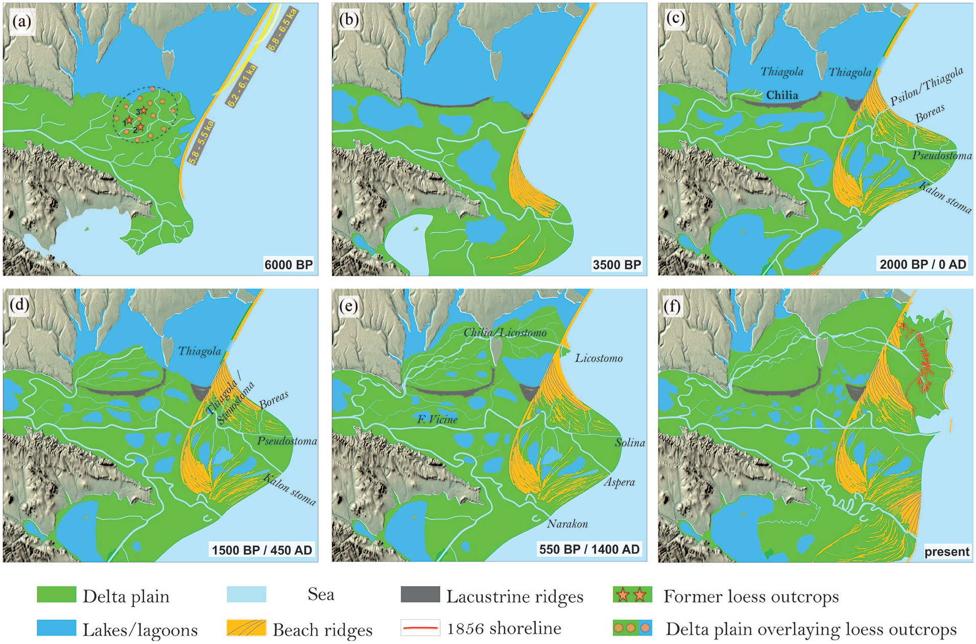
Chilia distributary development in the context of paleogeographical evolution of the northern Danube delta. Each subplot shows the central and northern delta configuration at various moments. (a) 6000 BP. (b) 3500 BP. (c) 2000 BP/0 AD. (d) 1500 BP/450 AD. (e) 550 BP/1400 AD. The dashed line in subplot A marks off the area where former loess islands/plateaus have been intercepted on cores and trenches; the numbered stars marks the sites of (1) Taraschina (Carozza et al., 2013); (2) Dâmbul lui Haralambie (Mihail et al., 2014), and (3) F3 core which was found suitable for human living in Chalcolithic. For each represented period hydronyms are in line with the chronology of the literary sources that mention them.
Further north, the Bronze Age tumuli from Chilia Promontory suggest that the ca. 5500–3500 yrs BP the populations in this region were related to the northern Yamnaya-Budgeak or Srubno-Hvalinsk archaeological cultures (Häusler, 1976; Motzoi-Chicideanu, 2011: 224−279; Vasiliu, 1995; Yarovoj, 1990). The tumuli formed series orientated north-south and east-west in line with the shores, marking the south-eastern extremity of the plateau during several millennia. The presence of river stones in the funerary inventories found in the tumuli (Vasiliu, 1995) could suggest these people came by foot from the plateau before the actual disconnection of the Chilia promontory (as a loess island) from the mainland. However, new data are needed to map the pre-deltaic loess extent, depth, morphology, and possible landuse.
Antiquity and Byzantine period (2500–800 year BP)
The chronostratigraphy of the upper part of the SIR and F18 cores indicates that the Chilia arm crossed (and silted) the Sireasa lagoon during early Antiquity and certainly prior to the 1850 yrs BP when entered the Pardina lagoon near the western end of the Stipoc lacustrine ridge plain. From this distal point, a secondary branch (the modern Pardina channel) developed eastward, parallel to the Stipoc ridge, reaching south of the Chilia loess promontory, and discharging (seaward) into the eastern compartment of the ancient Thiagola lagoon (Figure 9c), presently occupied by the Matița-Merhei basin. The northeast progression of the main Chilia distributary into Pardina basin led to its siltation and transformation into a wetland with interconnected shallow lakes ca. 1800–1300 yrs BP, as suggested by the chronostratigraphic data from F18, PAR1, PAR2, and KP1 cores which presents synchronous coarser fractions corresponding to river mouths advance and intense fluvial activity. The Stipoc North OSL age of 1.828 ± 0.12 ka (Figure 1 and Table 2) is another robust chronological mark dates the northernmost (distal) ridge and defines both the final stage of the Stipoc ridge plain formation (Figure 9) and the siltation of the western Thiagola lagoon (Pardina). This scenario is further endorsed by the chronology of the artifacts (randomly) found on the Stipoc ridge plain and by the texts attesting to the Roman conquest. Ca. 50 years after the first mention of the incipient phase of the Northern arm by Tacitus (Germania 1.3), Claudius Ptolemy mapped two major distributaries of the Chilia that discharged into lagoons north and south of Stipoc (Geography 3.10.2-3). These branches might correspond to the ancient course of the modern Pardina channel to the north of the Stipoc ridge plain and to the Șontea channel to the south. The Pardina basin drained by the northernmost distributary corresponds to Ptolemy’s “northern Thiagola.” Thus, the entire Thiagola lagoon should have been wider than suggested in previous studies (Panin, 1983; Romanescu et al., 2015): it covered an area of ca 1000 km², around the Chilia promontory between the Budgeak plateau to the north and west, and the Stipoc strandplain to the south, up to the Letea beach ridge plain to the east. Between the eastern tip of the Stipoc and the southern point of the Chilia promontory, an outlet ensured the water exchange between the two lagoon compartments (present-day Pardina and Matița-Merhei basins). As previously mentioned, Tacitus, Ptolemy, Ammianus Marcellinus described Thiagola waters draining into the sea through a mouth called itself Thiagola or Stenostoma which, based on the ancient descriptions (e.g. position, outlet orientation, water flow, and speed) we herein identify with Psilon (Magearu channel, Figures 3 and 9). Considering the chronology of the beach ridges flanking Magearu channel in the SW Letea ridge plain we interpret that Stenostoma denominated the decaying phase of the Psilon (Magearu). As at that time (ca. 2700–2000 yrs BP) Sulina arm (Pseudostoma) recorded the highest advancement rates, the discharge of its northern distributary decayed turning into a narrow and sluggish channel improper for navigation just as described by the ancients. Most probably it was mistakenly considered as the outlet of the vast lagoon and not a secondary branch of the Sulina arm.
One century after Ptolemy (during the fourth century AD), the Roman rhetor Aelian described Thiagola as an exceptional lagoon that resembled a sea between the Black Sea and the Danube (On the Nature of Animals 14.26). To the east, water exchange between the lagoon and the sea occurred through one or more inlets in the coastal barrier north of the Letea beach ridge plain. This was the only narrow sector of the barrier (between present-day Periprava and Prymorske). It was affected by erosion and roll-over migration and exposed to water-level oscillations (i.e. storm surges and river flooding) and barrier breaching. As such, this northern inlet/outlet was preserved for a long-time due to the intense water exchanges and generally to the lagoon water outflow into the sea, a situation reflecting Ammianus Marcellinus’ description of the seventh mouth (22.8.44), as septimum ingens et palustri specie nigrum “the seventh mouth is huge and black, in a kind of marsh.” Astonished by a new mouth which would be already “huge,” modern editors corrected the text, by making the mouth either segnius “sluggish,” or caenosus “muddy.” The description of northern outlet as a permanent breach of the coastal barrier connecting the lagoon (supplied by Chilia water) with the sea is nevertheless correct because a similar phrase is copied ca 1100 year BP, by Dicuil (On the Measure of the World 8.5), from a probable contemporary of Ammianus, Solinus (Wonders of the World 14): Septimum vero pigrum, ac palustri specie, non habet quod amni comparetur “The seven mouth is sluggish, in a kind of marsh, and has nothing of a river course.”
Medieval (Late Byzantine and Ottoman) times (800–250 year BP)
The chronological data show that the river mouth rapidly progressed east of the Chilia promontory in less than a century reaching the coastal barrier immediately north of the Letea ridge plain. The abrupt change of depositional environment east of the Chilia promontory, is also suggested by the microfauna assemblages found on the KIL core profile (Figure 8). The limited presence of foraminifera and ostracods in the silty layers between 300 and 223 cm, directly overlying the sterile loess (without microfauna) (Figure 7 – Unit A), suggests a hydrodynamically active environment, possibly indicating a former marine embayment shoreface where marine, brackish, and freshwater microfauna have been reworked before or during the Letea ridge plain development (Figure 7 – Unit B1). From 195 to 150 cm, the sediment texture coarsens with a relatively well-sorted upward layer of sandy silt and fine sand (Unit C in Figure 7), whereas from 180 to 152 cm, the microfossil assemblage becomes much richer and more diverse, proving the stable conditions specific to a lagoon with connections to the Black Sea (Figure 8 – Unit B2). Here, the in situ lagoon euryhaline foraminifera and brackish ostracods like those in the Black Sea are accompanied by freshwater ostracods transported to or living in the vicinity of the river mouth. The increase of the streamflow which brought about changes in the depositional environment from marine to brackish lagoon occurred ca. 800–700 yrs BP. The newly obtained age (670 yrs BP at 190 cm) is in line with the chronology of 900–700 yrs BP determined by Filip and Giosan (2014) for the same level at a nearby location east of the Chilia promontory. This change toward a more energetic depositional environment is also reflected in the higher Zr/Rb ratio (Figure 7). The presence of only freshwater ostracods starting at 152 cm indicates that the brackish lagoon environment connected with the sea had turned into a shallow freshwater lake/wetland rich in aquatic vegetation around 500 yrs BP (Figure 7 – Unit C) which was finally drained/restrained (Figure 7 – Unit D).
Considering the nearly simultaneous opening of the Chilia sea mouth near Periprava (Vespremeanu-Stroe et al., 2017), this proves that the Chilia discharge was reinforced ca. 700 year BP to allow the navigation from the sea. Further, this triggered the change of settlement development in the delta, with the Byzantine foundation and Genoese fortification of Lykostomion/Licostomo and the increased human impact on the northern Chilia/Lykostoma distributary, due to traffic, new economic activities (fisheries, agriculture), and wars. The inception of the Chilia sea mouth promoted the rapid updrift accumulation of sediments carried by longshore currents, which led to the formation of the Jibrieni beach ridge plain during the last 800 years (Vespremeanu-Stroe et al., 2017). At the same time, a new progradation phase started on the downdrift coast (eastern Letea) forming the L5 ridge set (cf. Vespremeanu-Stroe et al., 2013) (Figure 1). The chronology and sediment properties of this new ridge set of the Letea, which became the first unit of the downdrift wing of the Chilia open-coast lobe (Chilia 3), reveal the moderate (5–6 m/year) river mouth advancement rate during the 800–300 year BP interval, which later accelerated up to ca. 100 m/year until the mid-20th century.
Geomorphological processes in the open-coast Chilia lobe resulted in a complex morphology with two distinct features: (i) a set of beach ridges: L5 ridge set of Letea (downdrift) and Jibrieni (updrift), both built during the 800–300 year BP interval; and (ii) a rapidly advancing bird-foot secondary delta (300–10/0 BP). These changes at the mouth of Chilia are also captured by the contrast between the Medieval and Early Modern maps which show the mouth breaching the coastal barrier, and the late-18th and 19th century maps, illustrating the inception of the third lobe (Figure 3c).
The sharp contact between the L5 ridgeset and the older ridgesets of Letea strandplain (Figure 1) is marked by the finer (mean grain-size of 0.2 mm) and darker Danube (Chilia-born) sand in contrast with previously settled coarser (0.25 mm), brighter, quartz-rich sediments carried from the north (outside the delta) by the northern longshore currents (Zenkovich, 1956; Panin, 1989). Danube sediments appear in Letea ridge plain concomitantly with the formation of the Jibrieni ridge plain (0.8 ka ago). The basal age (732 ± 67 years: Figure 1 and Table 2) of the humus-rich layer overlying the contact between L4 and L5 ridgesets or between the white quartz-rich sand ridges (L4) and gray, mica rich fluvial sand (L5), marks the moment of the forest development perhaps as the local groundwater became fresh enough with the influence of the nearby Chilia branch. Other patches of oak forest on Letea ridge plain might be older (Preoteasa, 2008), but the forest evidently represented a new local source of timber for the construction of ships, barrels, and shelter.
In the northern part of Letea ridge plain, the imprints of some paleo-Chilia channels are marked on the current morphology as several elongated lakes and marshes in the S or SSE direction. Based on their position and size (widest: 200–250 m), we may assume that the Nebunu Lake is a remnant of the first Chilia channel formed during its early open-sea stage. However, the sediment load through this outlet was still modest as a large volume of sediments remained in the Matița-Merhei (western Thiagola) lagoon. We assume that the river plume was deflected southward by longshore currents and their load (longshore sediment transport – LST), which yielded high sedimentation index values (LST/Qs > 0.2; cf. Preoteasa et al., 2016). When the Chilia levees reached the coastal barrier transforming the former outlet into a river mouth, most of its sediments discharged into the sea and the mouth began to migrate toward ESE, favoring the formation of the Jibrieni ridge plain; another one or two secondary branches ran southward feeding a smaller downdrift secondary delta.
Chilia water and sediment discharge during the first stage (800–300/250 BP) of its open-coast lobe was assessed by computing the volume of sandy features of the delta lobe. As with the wave-dominated river mouth, the coarse fraction (i.e. sand) of river sediments are sorted and pushed upward by the wave asymmetry and incorporated into beaches, dunes, and upper shoreface (Anthony, 2015; Masselink et al., 2014). The reconstructed net LST of 0.7–0.8 × 10⁶ m3/year corresponds to a 4.6 km2/100 year surface growth rate of the L4 ridgeset. The basal sand was settled at 15–18 m depth in front of the Letea ridge plain prior of the Chilia outlet formation. This value was subtracted from the mean annual volume of sand incorporated into the Chilia 3 lobe during its first stage. Although the newly formed Chilia river mouth was large enough to support the development of a new updrift ridge plain (Jibrieni), it still allowed a significant southward bypass of LST over the river mouth as indicated by the coastal budget estimations. The annual sand volume captured in the open-coast Chilia 3 lobe, both in the Jibrieni ridge plain (7.8 km2) and L5 ridge set (38 km2), was estimated to be of ca. 1.2–1.45 × 10⁶ m3/year, which is equivalent to an annual river sand input of 0.5–0.65 × 10⁶ m3/year after subtracting the LST contribution from the total sand flux. If we assume a 1:10 ratio of sand from the total sediment load, as for the modern Danube (Panin and Jipa, 2002), the total sediment load of the Chilia distributary from the 13th to early 18th centuries was ca. 5–6.5 × 10⁶ m3/year. This load is equivalent to that recorded by the southern branch of Danube (Sf. Gheorghe) during 1900–1920 (Preoteasa et al., 2016) when its updrift coast was still prograding despite the increasing LST bypass over the river mouth once with the emergence of a downdrift barrier island (Sacalin). To compute the equivalent water discharge for the Chilia branch, we used the reconstructed river load and the water-sediment ratio of the Danube recorded at the delta apex (Ceatal Izmayil) between 1840 and 1970 prior to the construction of large dams on the Lower Danube. A mean value of 1300–1600 m3/s was obtained for the medieval Chilia water flow, which is equivalent to the present-day discharges of the Sf. Gheorghe or Old Stambul river mouths. Considering the present morphology of the two distributaries we assume that the medieval Chilia main channel should have been deeper than 6 m upstream of the Periprava and Chilia and further upriver. As such, until the last 300/250 years, these conditions allowed medium and large boats to circulate, although navigation remained difficult in the river mouth area.
Since 14th century (ca. 700 BP), the Chilia became the main upstream navigation route through the delta which triggered the new settlements foundation as Licostomo-Chilia along this branch. We locate the settlement in the historical center and around the harbour of New Chilia (now in Ukraine) where fortifications, churches, and archaeological layers of urban habitation are documented (Diaconu, 1995-1996 contra Iliescu, 1994). When the Ottomans settled Chilia fortress in 1484 AD, they gave the name “Old” Chilia, Eski Keli(a), to the loess island south of the distributary where they disclosed the population of the recently conquered city (as recorded in the Venitian Annals of Domenico Malipiero, resumed by Francesco Longo: Iorga, 1899: 158−163; Popescu, 2013; Sagredo, 1843: 135). Archaeological traces of a rural settlement in the south-eastern part of the Chilia loess island (at Câşla), which date back to 1550–1700 AD (400–250 year BP), could correspond to one of the settlements of these populations who were forced to work in the fisheries set up by the Ottomans to export fish to Christian countries (Beldiceanu and Beldiceanu-Steinherr, 1975; Mănucu-Adameșteanu, 2020: 245−247). On the site of Licostomo-Chilia, the Ottomans reconstructed the city as “New Chilia,” Yeni Keli(a) and repopulated it with Muslims. Parts of its walls were still visible during the 20th century (Iorga, 1929; Şlapac, 2016), recalling the importance of this regional hub situated at the crossroads of the sea-, river-, and land roads connecting Eastern Europe and Western Asia.
The Ottoman conquest of the city in 1484 AD and the entire Budgeak plateau in 1538 AD, followed by the demographic growth and the change of the economic activities in the region (Beldiceanu, 1968, 1976), left a substantial ecological imprint in the area, directly visible on the KIL core stratigraphy (Figure 6). The thickest dark layer at 145–120 cm (470 cal. year BP 9, Figure 7) with visible traces of burnt material could be the consequence of the combats between the Moldavians and the Ottomans in the 1480s, with destructions in the city of Licostomo-Chilia, but also of the forced relocation (sürgün) of Christian populations to the delta and the necessary burning of reeds to open up new navigation channels and install fisheries.
Most probably the progression of the Chilia distributary east of the Chilia promontory and the creation of its first open-sea lobe were favoured by the higher water and sediment discharge, associated with a flood-rich period, as frequently documented in the Danube basin during the Little Ice Age (LIA) (Blöschl et al., 2020; McCarney-Castle et al., 2012). Increased flood frequency within the Danube basin during the 15th to 16th century AD has been reported by Kiss and Laszlovsky (2013)and Perșoiu and Perșoiu (2019). The relatively shallow water depths across which the Chilia progressed contributed to the rapid extension of its lobes. Several significant runoff events were documented in Romanian Carpathians where the following flood events are synchronous with most of Central and Eastern Europe: 1050–1300, 1450–1550, 1650, and 1725–1980 AD (Longman et al., 2019; Rădoane et al., 2019). These flood events might have contributed to increasing the sedimentation rates in the Danube delta. Nevertheless, several simulations show that during 1500–1850 AD, the suspended sediment flux must have been 60%–80% higher than it is today (McCarney-Castle et al., 2012).
Modern times (200-250 year BP – present)
In less than 300 years, the Chilia built a large bird-foot delta of ca. 450 km². The transition from the wave-dominated morphology of the medieval Chilia mouth with its open-sea lobe with beach ridges flanking the river mouth to a river-dominated morphology began ca. 250 year BP. The bird-foot shape reached its maximum extent during the 19th century, as visible in old cartographic documents (1771, 1797, 1857) (Vespremeanu-Stroe et al., 2017). This is consistent with the recently reported flood-rich periods across Europe, although the triggering factor was most probably a massive increase in solid discharge due to intense land-use changes in the lower watershed (Kaplan et al., 2009), especially in the Romanian principalities that gained the right to export cereals to Western Europe after the Treaty of Adrianople (1829). This stimulated a new phase of extensive deforestation and created a surge in sediment load for the Carpathian rivers. Consequently, the Danube mouths created the largest shallow subaqueous platforms, which enabled the rapid development of the secondary river-dominated delta at the Chilia mouth during 1750–1940. This new deltaic environment attracted several waves of Russian Old Believers (escaping Tsarist religious persecutions) as well as Ukrainian and Romanian fishers and cattle breeders (who founded the villages of Letea and Sfiştofca on the Letea ridge or reinforced the demography of the city of Old Chilia).
In this phase, a dense network of bifurcating branches fed the Chilia lobe, whereas the channel mouths multiplied from 12 in 1856 to 20 in 1898, and up to 30 in 1935–1944, forming a highly indented coastline as shown on the historical maps (Panin and Overmars, 2012; Vespremeanu, 1984). However, the lobe advanced through three stable main branches: Ochakov (north), Bystroe (central/east), and Old Stambul (south). The average progradation rates of the Chilia lobe remained almost constant and very high (ca. 100 m/year), and the overall length of the lobe increased more than threefold due to the growth in the lobe surface brought about by intense development over the last 200 years, from less than 1 km2/year (late 18th century) to 1.3 km2/year (mid-19th century), 2 km2/year (1900), and then ca. 3 km2/year during the first decades of 20th century (Vespremeanu-Stroe et al., 2017). Moreover, the progressive elongation (since 1857) of the Sulina mouth jetties (S) contributed to the rapid siltation of the embayment and modern Chilia delta shoreline progradation, especially for the southern (Stambul) branch.
The last turning point in the evolution of the modern Chilia occurred in the mid-20th century when the specific wave-dominated morphology and morphodynamics (e.g. barrier islands, spits; reduction of the distributary network) reappeared in response to water and sediment load reduction. The main northern branch (Ochakov) started to recede at a fast rate (up to 50 m/year), while the coast progradation was confined to the southern part of the lobe (especially Old Stambul), thus accentuating the asymmetry of the lobe.
Conclusions
The analysis of new sedimentological, geochemical, and microfauna data and the critical interpretation of historical and archaeological information allowed us to reconstruct the natural evolution of the Chilia distributary, which can be correlated with different phases of human inhabitation.
The northernmost branch emerged during Antiquity, ca. 2500 yrs BP when it filled up Sireasa basin, close by the delta apex. Prior to fluvial advection into the northern part of the Danube delta, the nomad and semi-nomad populations of fishers or cattle breeders temporarily occupied the brackish lagoons’ shorelines and pre-deltaic loess islands and promontories and built funerary monuments.
Since Roman times (ca. 2000 yrs BP), once with the progression of the Chilia river mouths, the former brackish lagoon Thiagola (occupying present-day Pardina and Matita-Merhei basins) began to transform into wetlands with shallow lakes interconnected by fluvial channels. The terminus ante quem is ca 1800 year BP for the progradation into Pardina paleolake (called by Ptolemy the “northern Thiagola”) and the formation of a “narrow” Thiagola/Stenostoma channel described by ancient texts. The cultural remains on pre-deltaic Chilia Promontory, together with our geoscientific data and absolute ages on KIL core, suggest that terrestrial connection with the mainland (between Old and New Chilia) could have lasted until the end of Antiquity.
The last 800 years witnessed the expansion of the Chilia arm through the Chilia peninsula, up to the sea. The growing rate of outflow through this major distributary favored the development of the Licostomo-Chilia trading hub, successively controlled by the Byzantines, Genoese, Moldavians, Ottomans, Russians, and nowadays part of Ukraine, at the strategic point of New Chilia.
The presence of fluvial sediments in the eastern part of Letea ridgeplain marks the emergence of the third (last) deltaic lobe of the Chilia arm. Since then, the Matița-Merhei basin transformed from a brackish semi-enclosed lagoon into a delta plain with large and shallow lakes, channels, and reed marshes, whilst the river mouth and deltaic lobe (Chilia 3) shoreline switched from wave-dominated during 800–250 yrs BP) to river-dominated (250–10/0 yrs BP) and back to wave-dominated (last 70 years) for the youngest Chilia lobe.
Footnotes
Acknowledgements
Professors Maria Rădoane and Emil Vespremeanu are acknowledged for their inspiration and support. We thank to our colleagues and friends who helped during the fieldwork campaigns: Daniel Ivanov, Florin Tătui, Răzvan Popescu Mihaela Dobre, and our best friend Goji. The fruitful discussions with Gheorghe and Mihaela Mănucu-Adameșteanu, Cătălin Lazăr and Georges Tolias greatly improved our understanding of the archaeological findings, historical texts, and maps. Dr. Gabriela Sava and Daniela Pascal helped us pre-processing the material for radiocarbon dating. Professor André Sawakuchi provided us the facilities of the Luminescence and Gamma Spectrometry Laboratory (LEGaL), Institute of Geosciences of the University of São Paulo (USP).
Author contributions
LP proposed the project, conceived, and wrote the draft of the paper together with AVS and AD. AVS contributed to the sections dealing with the palaeogeographical reconstruction. AD did the research on the maps, manuscripts, and archaeological archives, and provided the final version of the archeo-historical contribution to this paper; CP provided the draft for sedimentological and MS data; MS performed the microfauna inventory and wrote the paragraphs dealing with microfauna data. TS provided the radiocarbon ages; FP provided the OSL ages; performed texture analysis and worked on the draft of the figures. DO and DM undertook the XRF measurements; LI, AS, and SA contributed with the documentation of the archaeo-historical data; LȚ delivered the sedimentological data and the draft of the figures. FZ contributed to the draft of the figures. LP, AVS, LȚ, FZ, and FP participated to the fieldwork coring campaigns.
Funding
The author(s) disclosed receipt of the following financial support for the research, authorship, and/or publication of this article: This work was financed by two grants of Romanian Ministry of Research and Innovation, CNCS -UEFISCDI, project number PN-III-P1-1.1-TE-2016-1750 (110/2018) and from PFE 15/2018. Part of the research leading to these results has received funding from the Norway Grants 2014-2021 RO-NO-2019-0415 (ClimaLAND), under project contract no. 30/2020. FZ has benefitted from the support of the Romanian Young Academy (funded by Stiftung Mercator and the Alexander von Humboldt Foundation). FNP is supported by National Council for Scientific and Technological Development (CNPq, Brazil), grants #302411/2018-6.