
Abstract
This paper presents the results of pollen, diatom, charcoal, and sediment analyses from Lake Bol’shoye Zavetnoye, situated between the Gulf of Finland and Lake Ladoga on the Karelian Isthmus, north-western Russia. The main goal is to contribute to the discussion of Neolithic land use in north-eastern Europe. The article aims to answer questions related to Stone Age hunter-gatherer economy, ecology, and anthropogenic environmental impact through a comprehensive combination of multiple types of palaeoecological data and archaeological material.
According to diatom data, Lake Bol’shoye Zavetnoye was influenced by the water level oscillations of Ancient Lake Ladoga during much of the Holocene. Intensified human activity and prolonged human occupation become visible in the Lake Bol’shoye Zavetnoye pollen data between 4480 BC and 3250 BC. During the final centuries of the Stone Age, a new phase of land use began, as several anthropogenic indicators, such as Triticum, Cannabis, and Plantago lanceolata appear in the pollen data and a decrease in Pinus values is recorded. In general, the results indicate that socio-cultural transformations could have taken place already from the mid-5th millennium BC onwards, including new ways of utilizing the environment, perhaps also in the field of subsistence, even though the livelihood was based on foraging throughout the period.
Keywords
Introduction
Due to global climate change, human impact on the environment has become a burning topic for the Anthropocene of the early 21st century. However, human-environment relationships can be traced to the early history of mankind. In discussing prehistoric societies, changes taking place in human communities are often seen as a direct response to climatic and environmental change. Even though, in many cases, nature placed clear boundaries on human action, there is no reason to neglect social and cultural drivers – prehistoric humans had an impact on the environment, too.
In the context of traditional or prehistoric societies, productive livelihoods (cultivation and animal husbandry), often appearing together with large and sedentary settlements, have been linked with the first occurrences of substantial anthropogenic environmental impact (e.g. Boivin et al., 2016; Kennett et al., 2006; Snitker, 2018). Hunter-gatherers, living more “in tune with nature”, would have had a smaller effect that may not necessarily even be visible in the palaeoecological records. Even though some ethnographic examples show that the latter also affect their environment (e.g. Adaev, 2017; Sauer, 1971), views on the topic have remained static and research limited.
In the traditional western European view, the productive livelihoods are connected with the concept of the Neolithic, but this cannot be held as a universal axiom. In eastern Europe and the Eurasian boreal zone, the appearance of pottery production has been considered as the main criterion of the period: despite continuing to rely on hunting, fishing, and gathering for subsistence, human groups adopted many other novelties and underwent major changes, which resulted in advanced and complex societies (Gurina, 1973; Oshibkina, 2006). This is in accordance with the recently advocated diverse view on the Neolithic (see Barker, 2006; Nordqvist, 2018; Thomas, 2016), which tries to avoid the simplistic juxtaposition between cultivators and hunter-gatherers.
North-eastern Europe provides a good setting for exploring hunter-gatherer encounters with the physical environment during the period labeled here as the Neolithic, that is, ca. 5500–1800 BC. The present study is based on materials from the area of the Karelian Isthmus, situated between the Gulf of Finland and Lake Ladoga in north-western Russia (Figure 1). Over a century of archaeological research has revealed more than 300 Stone Age and Early Metal Period sites, which provide evidence of intensive hunter-gatherer presence in the area during the Holocene (Gerasimov et al., 2003; Kulkova et al., 2015; Nordqvist et al., 2009; Seitsonen et al., 2017).
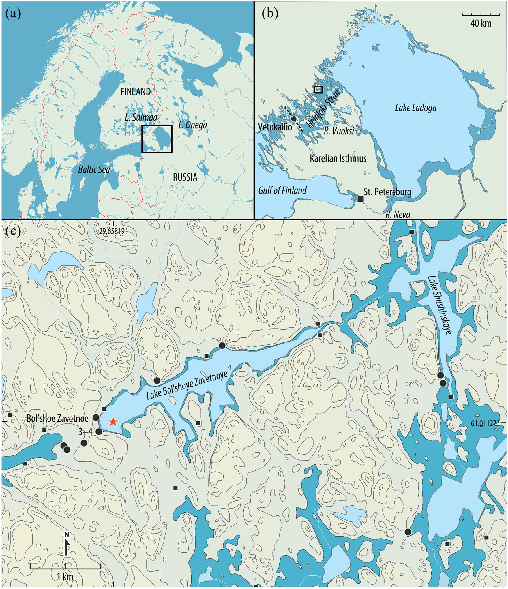
(a) The location of Lake Ladoga and the Karelian Isthmus in north-eastern Europe. (b) Map showing the maximum area covered by Ancient Lake Ladoga before the formation of the Neva outlet. The Vetokallio threshold separated the waters of the Baltic and Ladoga Basins, connected through the Ancient Heinjoki Strait until the birth of the River Neva. The location of Lake Bol’shoye Zavetnoye is marked with a rectangle (redrawn from Saarnisto and Grönlund, 1996). (c) Lake Bol’shoye Zavetnoye and its surroundings. The present water level (17.2 m in BZL) is shown in light blue. Darker blue represents the 20-m level and approximates the hydrological situation during much of the Neolithic. Black dots indicate the locations of Stone Age–Early Metal Period sites and black squares indicate the stray find locations in the area. The sediment coring site is marked with a red star. Contours at 10-m intervals.
The Karelian Isthmus has been a sensitive environment whose natural setting was heavily shaped by the oscillations of water levels in Lake Ladoga and the Baltic Basin. These changes were the result of post-glacial isostatic land uplift, which still continues, as well as changes in global ocean levels (see Gerasimov and Subetto, 2009; Saarnisto and Grönlund, 1996). Evidence of these oscillations is well preserved in lake and bog sediments, as well as in stratified multilayer archaeological sites. The dynamic environment also posed challenges for the prehistoric populations, which were often dependent on the exploitation of aquatic resources (Seitsonen et al., 2017): settlement sites are customarily located on the shores of Ancient Lake Ladoga or along the labyrinthine water route connecting the lake and the present-day Gulf of Finland (Figure 1a, b).
Lake sediments accumulated in small lakes are suitable for pollen-based land use reconstructions of prehistoric populations (Bennett and Willis, 2001). There is a number of small basins suitable for such studies in the central and northern parts of the Karelian Isthmus. However, many of them were isolated from Lake Ladoga only after the formation of the River Neva that took place between 1460 and 1300 BC (see below) and allow following land use and human activities only after this time, that is, from the Bronze Age onwards. While several investigations concentrated on studying anthropogenic impact in the Bronze and Iron Ages (and later) have been conducted on the Karelian Isthmus (e.g. Alenius et al., 2004; Miettinen et al., 2005; Taavitsainen et al., 1994; Saarnisto and Grönlund, 1996; Vuorela et al., 2001), high-resolution pollen analyses focusing on human-environment interaction and anthropogenic impact on vegetation during the earlier periods (Mesolithic-Neolithic) are scarce so far (see Dolukhanov et al., 2010; Kulkova et al., 2014).
In order to capture the earliest and often very slight anthropogenic signals and to understand human-environment interaction on the Karelian Isthmus, it is necessary to produce accurate, high-resolution proxy data from lake sediments that also cover the Stone Age. Lake Bol’shoye Zavetnoye (also Fi. Juoksemajärvi), situated on the northern Karelian Isthmus, was also influenced by the water level oscillations of Ancient Lake Ladoga during much of the Holocene. This paper presents the results of pollen, diatom, charcoal, and sediment analyses from this lake basin and traces its environmental history. Lake Bol’shoye Zavetnoye was chosen as a study site because (1) the lake was a small and sheltered bay during much of the Mesolithic and the Neolithic and therefore suitable for studying land use history, and (2) the basin is located optimally with respect to archaeological sites and research input. Intensive archaeological studies on the shores of the lake have revealed traces of human activity from the Late Mesolithic to the Late Neolithic (Halinen et al., 2008; Nordqvist and Lavento, 2008). The main goal of this paper is to contribute to the discussion of Neolithic land use in north-eastern Europe. The article aims to answer questions related to Stone Age hunter-gatherer economy, ecology, and anthropogenic environmental impact through a comprehensive combination of multiple types of palaeoecological data and archaeological material.
The following archaeological periodization is used in this paper: Mesolithic 8700–5300 BC; Early Neolithic 5300–3900 BC; Middle Neolithic 3900–2800 BC; Late Neolithic 2800–1800 BC; Early Metal Period/Bronze Age 1800 BC onwards.
Study area and site description
Environmental setting
Lake Bol’shoye Zavetnoye (hence BZL; 61.01127°N, 29.65819°E) is located on the Karelian Isthmus between the Gulf of Finland and Lake Ladoga, approximately 130 km north of St Petersburg (Figure 1). The lake is about 1.2 km2 in size, and the maximum depth is 8 m with an average depth of 4 m. The current vegetation is dominated by coniferous and mixed forests, and the undergrowth consists of crowberry, lingonberry, and bilberry (Halinen et al., 2008). The mean annual temperature in the area is +3 °C, with the coldest temperatures in January (–9 °C) and the warmest in July (+16 °C). The mean annual precipitation today is 600 mm year-1 (Subetto et al., 2002b).
The research area belongs to the Vuoksi-Maritime (Vuoksa-Primorskaya) geomorphological province of the Karelian Isthmus, which is characterized by the predominance of morainic and fluvioglacial deposits (partly shaped by the Holocene water oscillations) and bedrock outcrops (Archaean and Proterozoic gneiss, granite, schist, diabase, and other crystalline rocks) (Saarnisto, 2003). In the BZL area, the landscape is dominated by fluvioglacial delta sediments and eskers located between rocky ridges. The terrain has a relatively steep profile, especially around the lake basin, with a relief amplitude between ca. 20 and 55 m (all elevations in the article are absolute meters above sea level in the Baltic system). Thus, the utilizable area is fairly narrow and human habitation in historical times has been restricted to individual houses and small field plots along the lake shores.
BZL (17.2 m asl) belongs to the Vuoksi drainage area, which flows into the Ladoga Basin. Today, it occupies a valley running roughly SW–NE and is about 3.4 km long and ca. 114 ha in size (Figure 1c). At the Late Pleistocene–Holocene transition, the Baltic Ice Lake (BIL) level sank rapidly by tens of meters to the level of the ocean in ca. 9500 BC, which led to the emergence of large land areas in NW Russia, including BZL (Saarnisto and Grönlund, 1996; Subetto et al., 2002a). After 9000 BC, the water level rose again, and the Ancylus transgression maximum, ca. 8500–8200 BC, is visible as the highest shore terrace (ca. 24 m) around BZL. Consequent regression then stabilized the water level at about 20–21 m during the Mesolithic around 7800 BC (Gerasimov and Kul’kova, 2003; Saarnisto, 2008). BZL was a long bay connected with the inner archipelago of Ancient Lake Ladoga and located at the northern end of the former Heinjoki Strait that joined Lake Ladoga and the Baltic Basin (Figure 1b).
The transgression of the Litorina Sea in the Baltic culminated between 5500 and 5300 BC. The Baltic coast on the Karelian Isthmus was affected by the sea level rise, while other areas might have been affected by the indirect influence of transgression (Gerasimov and Subetto, 2009; Miettinen, 2004; Miettinen et al., 2007; Saarnisto and Grönlund, 1996). In BZL, lithological and geochemical analyses have suggested an impact on the second terrace (23 m), possibly formed during the transgression (Gerasimov and Kul’kova, 2003; Gerasimov and Subetto, 2009). Similarly, the outburst of Ancient Lake Saimaa into Lake Ladoga through the newly-created River Vuoksi immediately after 4000 BC caused the water levels to rise 1–2 m in many parts of the Karelian Isthmus (Gerasimov and Subetto, 2009; Saarnisto and Grönlund, 1996; Saarnisto, 2003; Sevast’yanov et al., 2001). No clear traces of this event are, however, visible in the bottom sediments or in the stratigraphy of archaeologically investigated areas (Gerasimov and Kul’kova, 2003; Halinen et al., 2008). All in all, a major change in the water level took place only when the transgressing Lake Ladoga broke a new outlet through the River Neva between 1460 and 1300 BC (Dolukhanov et al., 2009; Saarnisto and Grönlund, 1996; Taavitsainen et al., 1994): the water level sank by ca. 3 m to its present level and the lake was finally isolated.
Archaeological context
Archaeological research in the BZL basin started in 1911, when some stray find locations were inspected in the area (Halinen et al., 2008). Studies were continued only in the late 1990s and early 2000s, when altogether seven Stone Age–Early Metal Period sites were documented on the northern and western shores of the lake (Lavento et al., 2001; Nordqvist and Lavento, 2008) and excavations were conducted at the site of Bol’shoe Zavetnoe 4 (Juoksemajärvi Westend) (Halinen et al., 2008; Timofeyev et al., 2003). In addition, several stray finds from the area are known (Figure 1c).
Most of the sites found in the surveys have produced just a few finds, and their character – and in many cases also their more accurate dating – remains unknown. However, at the western end of the lake there is a find zone that is approximately 300 m long (the sites of Bol’shoe Zavetnoe 3–4, that is, Juoksemajärvi West and Westend) and consists of numerous activity areas. It includes 10 housepits (remains of Stone Age pithouses) located in three concentrations – one at the ca. 24-m terrace, two others at the ca. 20–21-m terrace. The modern sand pit at the site may have destroyed some additional housepits. Only one housepit and a few test pits have been excavated in this vast area, but finds and observations provide evidence of multiple use phases of different ages.
The oldest human habitation on the Karelian Isthmus dates to the early 9th millennium BC (Gerasimov and Kriiska, 2018; Jussila et al., 2012). Even though the environment would have permitted settlement in the BZL area already in the Ancylus period, human presence here can be dated at the earliest to the Late Mesolithic, the 7th millennium BC, through some diagnostic finds and one radiocarbon dating (see Supplement 1 for radiocarbon datings obtained from the site of Bol’shoe Zavetnoe 4).The beginning of the Early Neolithic is connected with the appearance of Sperrings (or Early Comb) Ware, dated between 5300 and 4400 BC (older phase) and 4500–4000(3800) BC (younger phase) (Mökkönen and Nordqvist, 2019; Nordqvist, 2018). Sperrings Ware has been excavated from the western end of the lake. A few sherds of pottery resembling Pit Comb Ware have been discovered as stray finds, and they may also date to the second half of the 5th millennium BC (Nordqvist, 2018; Tarasov et al., 2017).
The next phase, Typical Comb Ware, is represented by materials from several locations around the lake, most of which are practically stray finds. Generally, Typical Comb Ware is dated to 3900–3400 BC (Nordqvist, 2018; Pesonen, 2004). The so-called Late Comb Ware, which is partly contemporaneous with it and partly later, is represented in the area by a few sherds. Starting from the mid-4th millennium BC, asbestos- and organic-tempered potteries also enter the stage (Nordqvist, 2018; Tarasov et al., 2017). No pottery unquestionably belonging to this phase is known in the BZL area. However, based on certain structural properties, diagnostic stone artifacts, and radiocarbon datings, the use of the excavated housepit on the 24-m terrace has been connected with this time (Halinen et al., 2008; Seitsonen et al., 2012), although the other groups of dwellings may be connected with Typical Comb Ware as well.
Corded Ware characterizes the 3rd millennium BC in many areas, but it is not present in the BZL materials. No finds dating to the turn of the Stone and Bronze Ages, the later 3rd or early 2nd millennia BC, are known either, except for one (otherwise undetermined) pottery piece with textile impressions found at the eastern end of the lake. However, based on some 14C datings, the final use phase of the excavated area at the Bol’shoe Zavetnoe 4 site has been placed in this period (Seitsonen et al., 2012).
The wide extent, thick and/or stratified cultural layers, and other settlement structures (pithouses and fireplaces) indicate that the western end of the lake has been used recurrently and that at least during certain periods the area has served as a more sedentary basecamp-like location, where at least part of the population stayed for extended periods of time (Nordqvist and Lavento, 2008). On the other hand, many of the smaller sites may represent short-term camp sites or task areas, although the uneven focus of archaeological research can introduce some bias into the general settlement picture. In any case, the BZL shores were utilized quite intensively and continuously for several thousands of years between the 7th and 3rd millennia BC, probably also later. The intensity of occupation varied at different times: some phases are represented by clear archaeological material, but some are only hinted at by radiocarbon datings whose connections to cultural or natural processes are not always clear.
Osteological material (burned bones) from excavations at the site of Bol’shoe Zavetnoe 4 indicates the importance of aquatic resources (fishing), supplemented by the hunting of terrestrial mammals, sealing, and fowling (Halinen et al., 2008). This data is in accordance with the observations made about the Stone Age and Early Metal Period hunter-gatherers at Lake Ladoga in general (Seitsonen et al., 2017). The earliest evidence (bones) of animal husbandry dates to the 1st millennium BC in the vicinity of Lake Ladoga (Yushkova, 2011) and even later on the Karelian Isthmus (Uino, 1997); this is considerably later than in the surrounding areas of Finland and Estonia (3rd millennium BC onwards; Lõugas et al., 2007; Bläuer and Kantanen, 2013), and may reflect a research bias.
Material and methods
Coring, sediment stratigraphy, and dating
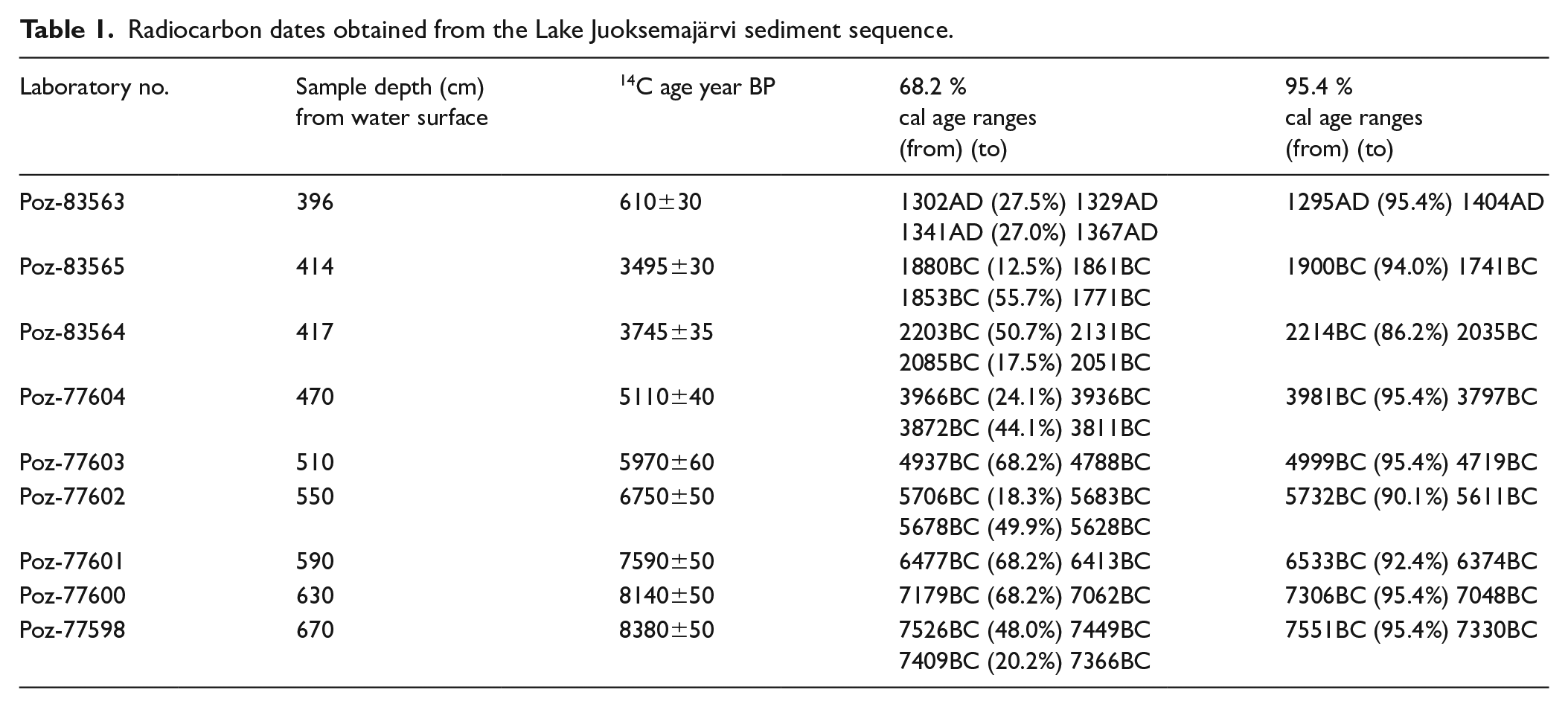
Sediment cores were taken from a bay at the south-western end of BZL, next to the vast Stone Age site of Bol’shoe Zavetnoe 3–4, at a spot where the water depth was 3.80 m (Figure 1c). The bay itself is about 27 ha in size, and in terms of pollen source area, it can be considered as a medium-sized lake. According to simulations, the relevant source area for medium-sized lakes is ca. 600–800 m from the lakeshore, with about 30–45% of the total pollen load coming from within this distance (Sugita, 1994). A set of partly overlapping sediment sequences consisted of five cores as follows (measured from the water surface): core 1 (3.8–4.8 m), core 2 (4.7–5.7 m), core 3 (5.6–6.6 m), core 4 (6.5–7.5 m), and core 5 (8.35–7.35 m) (Figure 2). LOI was determined at a 1-cm resolution by burning previously dried (105 °C, overnight) sediment samples in a furnace for 6 h at 550 °C. The sediment sequence was dated by means of nine accelerator mass spectrometry (AMS) dates obtained from 1-cm-thick bulk sediment samples in the Poznań Radiocarbon Laboratory (Table 1). All of the dates were calibrated using OxCal 4.3 [118] (Bronk-Ramsey, 2009), which employs the IntCal13 atmospheric curve (Reimer et al., 2013). The age-depth model was likewise created with OxCal 4.3 using the deposition model P Sequence (Bronk-Ramsey, 2008).
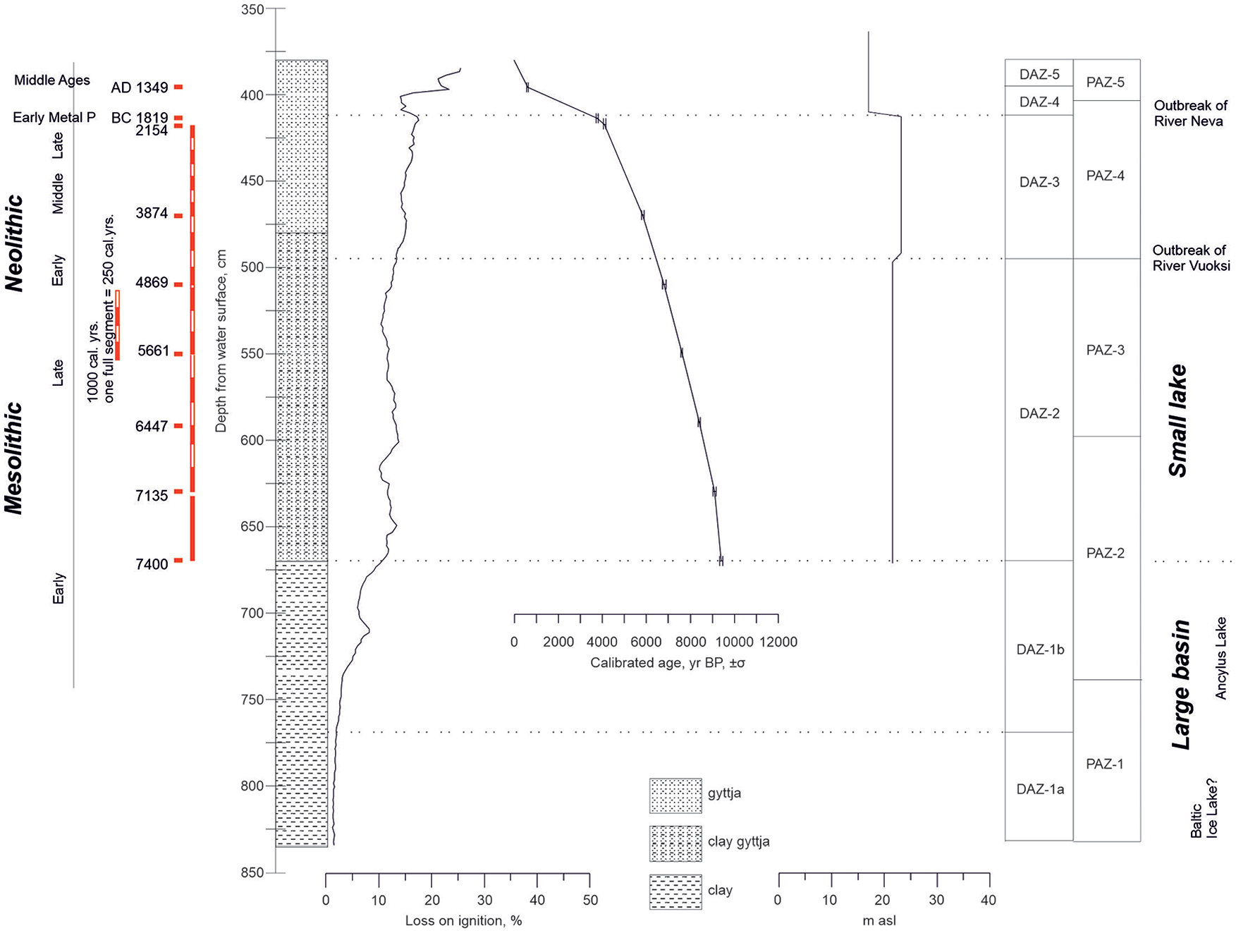
Sediment stratigraphy, loss-on-ignition, shore displacement curve (showing water level fluctuations during the “small-lake” phase) and the age-depth model based on nine calibrated radiocarbon dates (obtained from bulk sediment, see Table 1) of the Lake Bol’shoye Zavetnoye sediment sequence.
Radiocarbon dates obtained from the Lake Juoksemajärvi sediment sequence.
Pollen and charcoal analyses
Subsamples for pollen analysis were prepared according to the procedure suggested by Bennett and Willis (2001). For calculations of pollen and charcoal (⩾10 μm in size) concentrations (number of pollen grains or charcoal particles per cubic centimeter of sediment), two Lycopodium tablets (Stockmarr, 1971) were added to samples of 1 cm3 in volume before preparation. A minimum number of 600 pollen grains were counted. In order to obtain a high temporal resolution for the Neolithic period, sediment cores were analyzed at a high-resolution (in each cm) from the surface until 550 cm, that is, until 5656 BC. The lower parts of the sediment (550–800 cm) were analyzed using a resolution of 10 cm. Due to the low pollen concentration in the clayish lowermost part of the sediment (740–800 cm), only ca. 100 pollen grains were counted. The identification of pollen species was based on the publications of Erdtman et al. (1961), Fagri and Iversen (1989), Moore et al. (1991), Reille (1992, 1995), and Beug (2004).
Calculations for pollen percentages were based on the basic sum of terrestrial pollen grains, P, that includes arboreal pollen [AP = including Picea (spruce), Pinus (pine), Betula (birch), and Alnus (Alder)], nonarboreal pollen (NAP), and noble deciduous trees [=QM including Corylus (hazel), Ulmus (elm), Quercus (oak), Tilia (lime), Carpinus (hornbeam), Fraxinus (ash), and Fagus (beech)]. The aquatic pollen and spores were calculated from the sums P + AqP and P + Spores. Biostratigraphical data treatment and diagrams were handled with Grimm’s (1991) TILIA and TILIA GRAPH programs. Stratigraphically constrained cluster analysis (CONISS) was used to assist zonation (Grimm, 1987, 1991). In the zonation, count data were used and aquatics and spores were removed from the analysis.
Diatoms and other microbiomorphical analyses
The diatoms, chrysophyte cysts, and sponge spicule phytoliths were analyzed from 1-cm-thick sediment samples collected at intervals of 5–10 cm for most of the sequence, except the uppermost 0.3 m, where the samples were taken at a resolution of 1–2 cm. The samples were dried and weighed for further calculation of the diatom concentration. The laboratory treatment and diatom slide preparation followed the standard procedure with the oxidizing of the organic matter in H2O2, followed by fractionizing in heavy liquid (Cd2J+KJ, specific density 2.6 g·cm-3) for mineral sediments and subsequent washing in distilled water (Davydova, 1985). The residual material was diluted with a measured amount of water and stirred carefully. A drop of 0.1 ml of the suspension was used for slide preparation.
Diatom identification follows Krammer and Lange-Bertalot (1986–1991). Additional publications were used for the identification of Aulacoseira taxa (Camburn and Kingston, 1986; Haworth, 1988; Siver and Kling, 1997). Other aquatic siliceous microfossils, chrysophyte cysts (Chrysophycea, golden algae), and sponge spicules (structural elements of aquatic invertebrates, Porifera), were counted alongside with diatoms. The absolute abundances (concentrations in g-1 of dry sediment) of each group of microfossils were subsequently calculated following the method outlined by Davydova (1985).The diatom assemblage subdivision into “large-lake species” and “small-lake species” was based on Risberg et al. (1996) and Hedenström and Risberg (1999) with amendments from Jouse (1961) and Ludikova (2015). The diatom diagram was drawn using the palaeoecological software C2 Version 1.5 (Juggins, 2007).
Results
Lithostratigraphy and physical parameters
The studied sediments consist of gray thin-layer clay smoothly turning into brown clay gyttja and overlaying gyttja in the upper part. The content of organic matter in the core gradually increases from 1 to 25%. Smooth changes in the content of organic matter indicate the absence of interruptions in sedimentation throughout the Holocene history, with the exception of the Late Holocene (Figure 2).
Based on the amount of organic matter content in the core, several periods of sedimentation are distinguished. Deposits from 835 up to a depth of 765 cm are composed of minerogenic fine sediments with consistently low LOI values (up to 2%). Above this (765–734 cm), a gradual but steady increase in the content of organic matter was observed. From 734 cm onwards, the content of organic matter in sediments increases more rapidly, and, having exceeded 10% no later than 7550 BC, remains in the range of 10–17% up to 1700–1900 BC (413 cm). There are several periods of decline in the LOI values: at depths of 710–680 cm (up to 7550 BC), 625–615 cm (7050–6800 BC), and 540–525 cm (5550–5050 BC). At depths of 413–400 cm, there was a sharp decrease in the LOI values, after which a sharp increase in the maximum values in the upper samples was observed. Against this background, at depths of 397–390 cm, there is a decline in the LOI values.
Chronology
The age-depth model, which is based on nine AMS dates of the core sample (Table 2), is presented in Figure 2. The age-depth model suggests a continuous sedimentary archive since about 7540 BC (670 cm; Poz–77598) and 1811 BC (414 cm: Poz-83565) with an average deposition rate of 0.22 mm year–1. In the uppermost part of the sediment, between 414 and 396 cm, there is a very considerable drop in sedimentation rates, and most probably a hiatus.
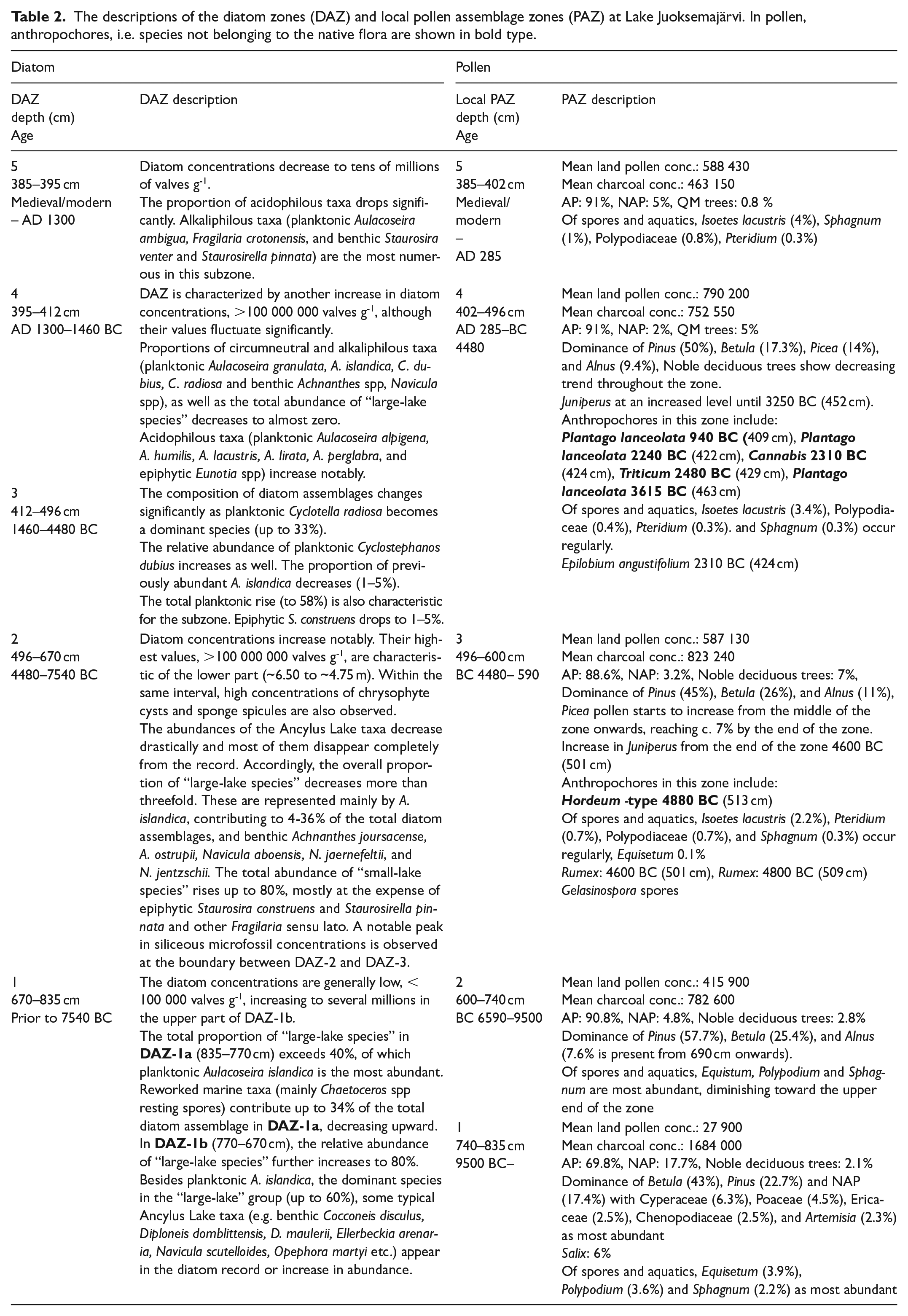
The descriptions of the diatom zones (DAZ) and local pollen assemblage zones (PAZ) at Lake Juoksemajärvi. In pollen,anthropochores, i.e. species not belonging to the native flora are shown in bold type
Diatom, pollen, and charcoal records and other microbiomorphical analyses
Four local diatom assemblage zones (DAZ) were recognized based on the changes in diatom species composition and diatom valve concentration (Figure 3). The pollen record was divided into five local pollen assemblage subzones (PAZ) according to CONISS (Figure 4). The descriptions of the local diatom and pollen assemblage zones, as well as charcoal data, with the accompanying interpretations are presented in Table 2. The results for the phytoliths turned out to be uninformative and were therefore not included in the discussion (see Supplement 2). Concentrations for cysts and sponges are shown in Figure 3.
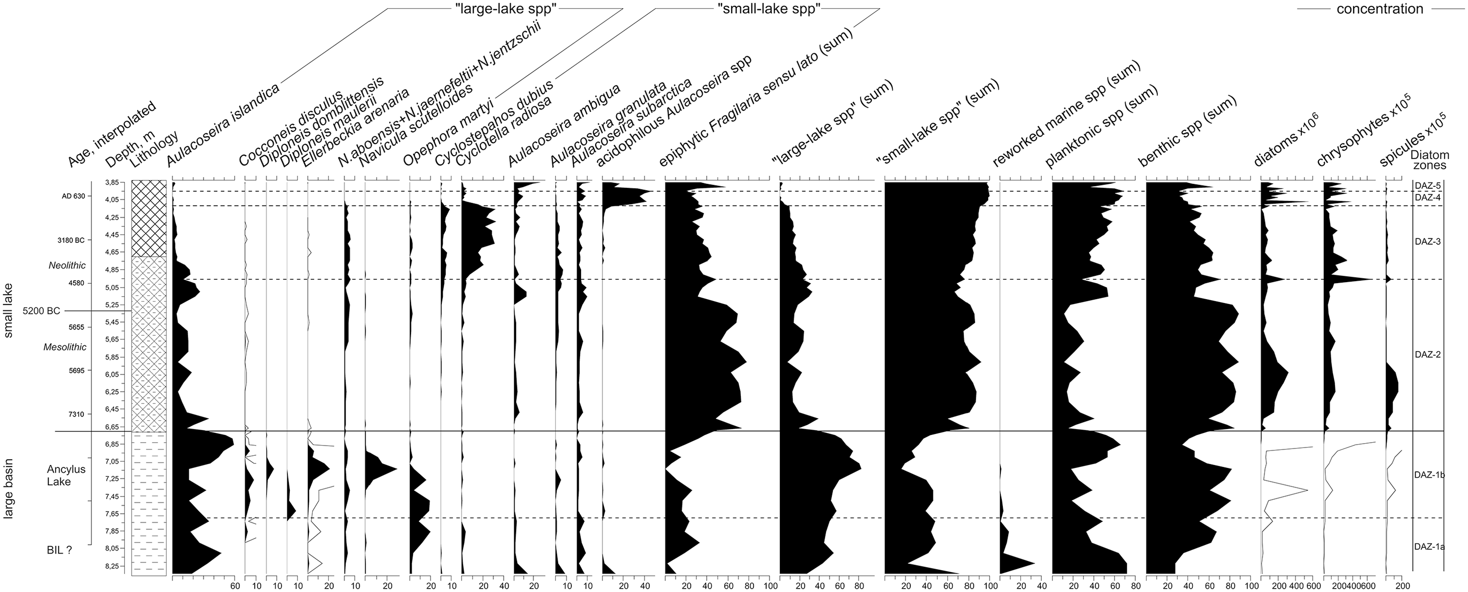
Diatom diagram of Lake Bol’shoye Zavetnoye. Concentrations for cysts and sponges are also shown.
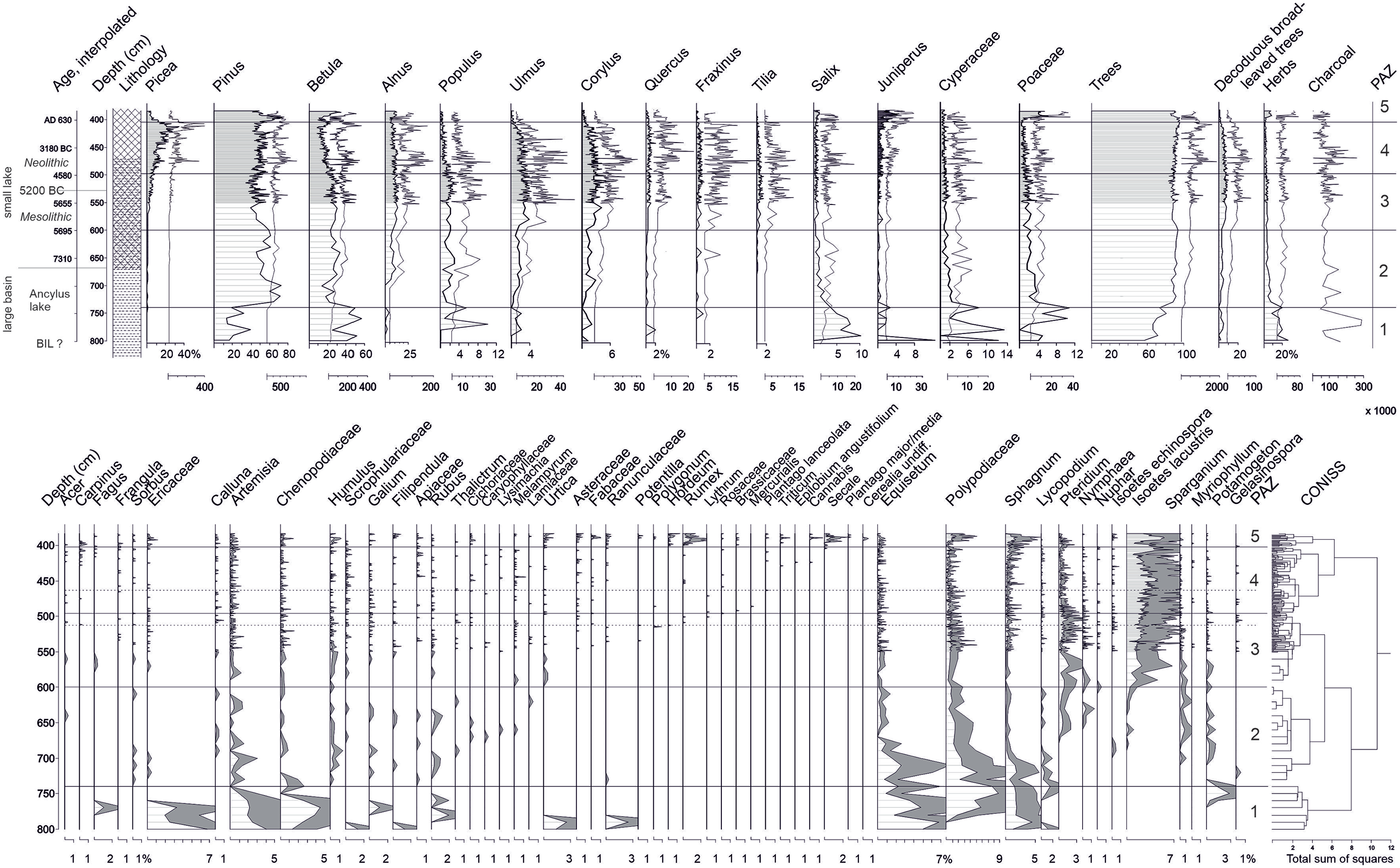
Upper pollen diagram: Main tree species and broad leaved deciduous trees, some shrubs, grasses, and sedges presented as pollen percentages (depth bars) and pollen concentrations expressed as grains/cm3 (silhouette diagram). Lower pollen diagram: herbs, spores, and aquatics expressed as pollen percentages. The exaggeration factor by factor 3 is shown in gray. Local pollen assemblage zones (PAZ 1–5) based on the CONISS analysis are shown on the right.
Discussion
Early stages of the palaeobasin; Baltic Ice Lake and Ancylus Lake
According to the radiocarbon dates (>6350 BC), the initial period of development of the lake corresponds to Early Holocene and probably Late Glacial times, when the large freshwater basins of the BIL and Ancylus Lake subsequently occupied vast areas in the northern part of the Karelian Isthmus. The overall predominance of “large-lake species” in the diatom assemblages in DAZ-1 suggests their accumulation in a large and deep oligotrophic lake, which is supported by low LOI values. Low diatom concentrations obviously refer to low productivity and high sedimentation rate. The presence of reworked marine diatoms especially abundant in DAZ-1a is characteristic of the freshwater diatom assemblages of the BIL and Ancylus Lake (Davydova, 1985; Ludikova, 2017). These species were redeposited from the eroded Eemian Interglacial sediments widespread in the Ladoga area. The lowermost phase (DAZ-1a) might therefore represent the BIL period. This is confirmed by the lowest LOI values in the corresponding part of the sediment sequence indicating mineral sedimentation in the basin. The presence of typical Ancylus Lake taxa in DAZ-1b suggests that the assemblages formed during the Ancylus stage of the Baltic, as BZL received the Ancylus waters from the Heinjoki Strait that connected Ancylus Lake to Lake Ladoga. The width of the connection can be estimated based on finds of Ancylus sediments in small lakes and terrestrial sections and outcrops. They give an estimate of ca. 20–30 km. The length of the Ancylus–Ladoga connection can be estimated to not have exceeded 80 km, which is approximately the present distance from the Gulf of Finland to Lake Ladoga in the northern part of the Karelian Isthmus. In the lowermost part of the pollen data (PAZ-1), Betula, Salix, and herb pollen such as Artemisia and Chenopodiaceae dominate.
The next stage in the evolution of BZL starts after Ladoga’s isolation from Ancylus Lake (DAZ-2). The isolation from Ancylus Lake with the subsequent significant regression has led to a steady increase in the organic matter content of the sediments. A radiocarbon dating obtained from the level at the beginning of DAZ-2 (670 cm; Poz-77598) resulted in a radiocarbon age of 7550–7330 BC. The dating agrees closely with the earlier estimate of 8100–8200 BC for the termination of the Ancylus transgression (Andrén et al., 2011; Rosentau et al., 2013; Saarnisto, 2008). The decrease in the LOI values at 710 cm (ca. 8000 BC, age-depth model) against the background of a general LOI rise along the profile is probably associated with the regression of Ancylus Lake and the subsequent re-formation of the banks with concomitant erosion. After this phase, calm hydrodynamic conditions prevail as the lake was a remote bay of Lake Ladoga and connected to it through a system of channels and lakes.
The lowering of the water level favored the growth of benthic species. The highest diatom concentrations observed in the earlier post-isolation phase (lower DAZ-2) result from extensive epiphyte production and suggest abundant macrophyte vegetation. The highest sponge spicule concentrations, if in situ, provide evidence of clearer aquatic environments. There are no archaeological indications of human presence from this period, and the settlement traces on the western shore of the lake have been dated at the earliest to the 7th millennium BC onwards.
Neolithic period and human impact
The beginning of the Neolithic was a period of substantial environmental change. In general, the Litorina transgression (with a maximum around 5500–5300 BC) directly affected the Baltic coast of the Karelian Isthmus (Gerasimov and Subetto, 2009; Miettinen, 2004; Miettinen et al., 2007; Saarnisto, 2003; Sapelko et al., 2008). The decrease in total benthic diatom abundance between 5700 and 4700 BC (Poz-77602 and Poz-77603; upper DAZ-2) in BZL may indicate some water level rise in the lake, which might be indirectly connected to the Litorina transgression and the proposed increase in catchment area (Gerasimov and Subetto, 2009; Sapelko et al., 2008). At the same time, the spread of Picea abies marks a significant change in the ecosystem (Giesecke et al., 2014; Sapelko et al., 2008; Seppä et al., 2009a). The gradual increase of Picea is visible in the pollen data from ca. 5800 BC onwards, and by 4480 BC it already makes up 7% of the vegetation. The climate developed toward the optimum; the highest Holocene Thermal Maximum (HTM) summer temperatures and the lowest relative humidity in Fennoscandia are recorded around 4000 BC (Heikkilä et al., 2010; Salonen et al., 2014; Seppä et al., 2009b).
Both diatom and pollen data show a distinct change starting from 496 cm upwards. In diatom data, this marks the beginning of DAZ-3 and in pollen data the beginning of PAZ-4. According to the interpolation of the time depth curve, this event dates to ca. 4480 BC. In the diatom data, there is a notable shift from Aulacoseira to Cyclotella predominance within the planktonic group. Increased abundances of eutrophic Cyclostephanos dubius and Cyclotella radiosa apparently indicate an increase in some nutrient levels. The gradually increasing proportion of total planktonic species might be also related to the water level rise. In the pollen data, the most notable change is a clear decrease in Betula and Populus pollen percentages and an increase in Juniperus. In fact, the increase in Juniperus is recorded already 5 cm lower (4600 BC onwards, according to interpolation), associated with a single Rumex pollen (dating to 4600 BC). Juniperus is an indicator of open heliophilous conditions, that is, it thrives in open areas and improved light conditions. In the Iron Age context in eastern Fennoscandia, it is usually connected to the appearance of grazing animals (Behre, 1981; Pykälä, 2007), but there is no evidence of domestic grazing animals in the osteological analyses conducted on material from BZL or eastern Fennoscandia during the Early and Middle Neolithic (Seitsonen et al., 2017). It can still be hypothesized that increased openness in the landscape and an increase in eutrophic conditions from 4600 BC, and more clearly from 4480 BC, relate to increased human activity and prolonged human occupation in the surroundings of BZL. The increase in eutrophic conditions is not likely to be a natural process, because a gradual rise in the water lever of Lake Ladoga (when the level of BZL is also thought to increase) could not result in eutrophication. Intensified human presence is also verified by the occurrence of other pollen taxa that are introduced and do not belong to the native flora, such as a pollen of Hordeum type dating to 4880 BC and concurrent with Rumex dating to 4800 BC. This is the oldest Cerealia pollen recorded thus far on the Karelian Isthmus. Pollen of Plantago lanceolata is dated to 3615 BC; it does not belong to the natural vegetation and is a good indicator of human land use (Behre, 1981; Hjelle et al., 2006).
In the charcoal data, a high fire frequency of about 940 years is recorded between 4090 BC and 3150 BC, suggesting the intentional use of fire by local populations. Apart from “domestic use”, fire has been exploited in the direct procurement of food. It has frequently been used for clearing vegetation to promote and stimulate the colonization and growth of particular (early successional stage) species of edible plants (Scherjon et al., 2015; Smith, 2011). Archaeobotanical data from Stone Age sites in mainland Finland shows that various nuts, fruits, roots, and seeds originating from wild plants were gathered especially in the southern parts of the country (Vanhanen and Pesonen, 2015). Edible plant species present in Finnish macrofossil materials that have a competitive advantage in the early successional communities and therefore benefit from forest fires include Rubus idaeus (raspberry), Juniperus communis (juniper), Corylus avellana (hazel), Fragaria vesca (wild strawberry), Filipendula vulgaris (dropwort root tubers), Prunus padus (bird cherry), Chenopodium album (fat hen), Rumex (sorrel) species, and Poaceae (grass family). Another reason for intentional burning is to create grazing lands for game. Burning creates environments – young forests and small-scale local openings in the wooded landscape – that are preferred by large ruminants, such as elk.
The beginning of high local fire frequency, however, overlaps temporally with the proposed outbreak of the River Vuoksi. Earlier, it has been speculated that the Lake Saimaa outbreak of the River Vuoksi and the start of the progressive rise in the level of Lake Ladoga immediately after 4000 BC might have caused the water level to rise by a meter or two (Saarnisto, 2003). Although the River Vuoksi breakthrough is not directly inferred from the diatom record, the peak in the concentrations of all groups of siliceous microfossils around the transition from DAZ-2 to DAZ-3 (ca. 4480 BC) might indicate a short-term critical event. Further increase in the relative abundance of planktonic taxa (DAZ-3) could result from the rising water level in the lake, probably in response to the Ladoga transgression. The proportion of “large-lake species” does not show any major changes, though. However, the pollen data shows an increase in the pollen concentrations of major tree taxa simultaneously with an increase in charcoal particles (ca. 4090–3150 BC). This increase in pollen concentrations as well as charcoal particles may be connected to changes in the deposition environment (rise in water level) and the subsequent redeposition of charcoal (and pollen) from the shores rather than the intentional use of fire by local populations.
From ca. 3510 BC onwards, a clear decrease in Picea forests is recorded, lasting until ca. 2845 BC. In contrast to the natural process in the boreal forest zone of northern Europe, where the Picea population gradually increased from the time of the initial expansion (Seppä et al., 2009a), this local decrease in Picea is very abrupt and unnatural, strongly suggesting anthropogenic causes. As the increased local fire frequency and decrease in spruce partially overlap, it is plausible that the use of fire was focused specifically on spruce-dominated areas around BZL.
The cessation in the intensified period of fire (ca. 3150 BC) is practically simultaneous with the drop of Juniperus values back to the preceding levels (ca. 3250 BC). In a broader sense, this can be interpreted as a general decrease in human impact from ca. 3250–3150 BC onwards. Despite the general diminishing of signs of human activity, the proportion of spruce forests stays low until ca. 2845 BC, suggesting a continuation of human activity that is especially focused on spruce-dominated areas.
Archaeological material from the BZL basin corresponds relatively well with palaeoecological observations of human impact. In general, the early signs can be placed in the context of Sperrings Ware; nevertheless, pottery from the western shore of the lake has features more typical of the older phase of Sperrings Ware, predominantly dating prior to 4400 BC. The few pieces of pottery resembling Pit Comb Ware are too vague to consider as evidence of increased human presence.
Typical Comb Ware that provides evidence of human activity in the early 4th millennium BC has been found in many places around the lake, and some of the housepits on the western shore may belong to this time. The housepits on the 24-m terrace have predominantly been connected to the subsequent asbestos- and organic-tempered wares, even if no pottery belonging unquestionably to these types was found in the excavations. However, human activity related to asbestos-tempered Pöljä Ware is present at the Pitkäjärvi site ca. 3 km SSE of the coring site, where investigations have also revealed a probable housepit of this period (Pälsi, 1918; Seitsonen, 2006). Except for the scattered radiocarbon datings, there is basically no archaeological material dating indubitably to the 3rd millennium BC, either.
Pithouses are typical of the 4th and early 3rd millennia BC. Their large numbers – sometimes housepits even occur in village-like clusters – have been interpreted as reflecting a growing degree of sedentism (Mökkönen, 2011). Increasing sedentism, that is, occupying same locations for prolonged periods within a year, as well as the recurrent use of the same places, naturally has a heavier impact on the environment. Deforestation and the opening of the landscape, well visible in the BZL pollen data between 4480 BC and 3250 BC, may result partly from clearing the immediate surroundings of settlement sites and acquiring firewood and building material, partly from subsistence-related activities.
Intensified human activity and prolonged human occupation, visible in the BZL pollen data between 4480 BC and 3250 BC, closely agree with the pollen results from Lake Huhdasjärvi, situated about 180 km to the west in eastern Finland. Here, the most active land use phase was likewise dated to between ca. 4400 and 3200 BC (Alenius et al., 2013, 2017). Around Lake Huhdasjärvi, an important part of human activity seems to have been connected with producing fibers from hemp and lime. Similarly, the mosaic of land use activity at Lake Huhdasjärvi resulted in an increase of open patches in the forest where light-demanding Juniperus and other apophytes, such as Plantago major/media, Caryophyllaceae, and Rumex could grow. Barley was also grown sporadically during this period around Lake Huhdasjärvi: Hordeum-type pollens were dated to ca. 4260 BC and to 3960 BC, suggesting that knowledge of agriculture had reached the area. However, the livelihood was still based on foraging throughout the period.
Indications of changing land use
During the final centuries of the Stone Age, a new phase of land use began, as several anthropogenic indicators appear in the pollen data. Dating to ca. 2480 BC (age-depth model), a pollen of Triticum type is recorded in the sediment, indicating sporadic cultivation. This is followed by Cannabis and Plantago lanceolata pollens dating to ca. 2310 BC and 2240 BC. From ca. 2170 BC, a sudden and pronounced decrease in Pinus values is recorded, suggesting the felling of pine forest. After 1900 BC, the palaeoecological record breaks in BZL because there is interruption in the sedimentation.
Archaeological material from BZL provides no information on the period in question: only a few radiocarbon datings without clearly accompanying find material are known from the excavations conducted in the area. This is a common trend in much of the inland region, where the archaeological signal of human activity weakens toward the end of the 3rd millennium BC. The reasons given for this include the increasingly deteriorating climate (also the 4.2 kyr event) and the subsequent depopulation, but also the adoption of archaeologically less visible ways of living and material culture (Lavento, 2015; Mökkönen, 2011).
Interestingly, however, palaeoecological records often provide evidence of human presence (cultivation) in areas where diagnostic (or any) archaeological assemblages are missing. The pollen data from Finland shows quite a diverse range of evidence connected to agriculture from around 2200 BC onwards (Alenius, 2007, 2008; Alenius et al., 2009; Augustsson et al., 2013; Tolonen, 1980; Vuorela, 1999; Vuorela and Lempiainen, 1988, see also Taavitsainen et al., 1998). Also, the earliest sure appearance of livestock (as determined based on osteological material) dates to the end of the Stone Age, ca. 2500–1950 BC (Bläuer and Kantanen, 2013). Dairy lipids have been detected on Corded Ware Pottery of the 3rd millennium BC (Cramp et al., 2014). All this indicates that the custom of cultivation (and animal husbandry) was becoming more common in north-eastern Europe during this time.
Outbreak of the River Neva: End of the record
The outbreak of the River Neva between 1460 and 1300 BC (Saarnisto and Grönlund, 1996; see also Kuznetsov et al., 2015) dropped the water level of BZL about 3 m to its present elevation (17.2 m). In BZL, the outbreak of the River Neva caused a profound decrease in the deposition rate and an increase in mineral matter content after 414 cm (ca. 1811 BC; Poz-83565), visible in the age-depth model and LOI curve and most likely reflecting the redeposition of sediment from freshly exposed land areas. It is plausible that the lowering of the water level caused strong erosion processes and that sedimentation was interrupted by the redeposition of material into deeper parts of the basin due to the new hydrodynamic conditions following the isolation. Human land use in the area can therefore be followed only until the beginning of the Bronze Age, ca. 1900–1740 BC. A substantial decrease in the proportion of “large-lake species” from the beginning of DAZ-4 (412 cm) appears to indicate that Ladoga waters no longer penetrated the lake basin (Ludikova 2015), and the predominance of acidophilous planktonic Aulacoseira taxa in the BZL diatom record suggests the paludification of the lake. The increase in humic substances lowered water transparency, which prevented the expansion of benthic diatoms and caused the predominance of Aulacoseira species, which are also known to tolerate lower water transparency (Camburn and Kingston, 1986; Siver and Kling, 1997).
The uppermost pollen and diatom zones (PAZ-5, DAZ-5) are deposited after the interruption of sedimentation caused by the lowering of the water level, and according to radiocarbon dating (396 cm; Poz-83563), they date to medieval times, ca. AD 1300. In the diatom record, DAZ-5 is characterized by slightly alkaline meso-eutrophic conditions, and the pollen data shows a cultural, open landscape dominated by hay fields and open meadows and the cultivation of Secale and Triticum. Again, no archaeological material is known from the BZL area itself, but the immediate surroundings form the core area of the so-called Late Iron Age and early medieval Karelian culture (Laakso and Belskiy, 2018; Uino, 1997).
Conclusions
This article contributes to the discussion of Neolithic land use and human impact in the boreal zone of north-eastern Europe. The stages of the Baltic Sea and the resulting changes in the water level have influenced the landscape and living environment of Neolithic populations on the Karelian Isthmus. During the Neolithic, the water level has been at approximately 20 m, and therefore the pollen source area is relatively large. This could decrease the visibility of rare pollen types and pollen originating from poorly dispersed pollen types, as a substantial amount of pollen comes from regional sources rather than local ones. The pollen data nevertheless demonstrates the large-scale effect that human activity has had on vegetation around the lake, such as a shift to more open, heliophilous conditions from 4600–4480 BC onwards until ca. 3200 BC.
Archaeological data indicates that the BZL area was occupied in the Late Mesolithic, at the Litorina stage, sometime after 7000 BC. Human presence is attested during the Early Neolithic between the Litorina transgression maximum and the Vuoksi breakthrough, as well as during the following millennium, the Middle Neolithic. The archaeological signal weakens with the onset of the Late Neolithic, the 3rd millennium BC, even though possible anthropogenic influence is suggested by some pollen and 14C data.
Several points are of interest here. First, based on the present data, human habitation in the BZL area can be proven only 2 millennia after the initial colonization of the Karelian Isthmus – it cannot be judged here whether this is the result of research bias or something else. Second, the suggested increasing human activity and prolonged human occupation observed in pollen data from both BZL and Huhdasjärvi (situated about 180 km apart) from ca. 4400 BC to 3200 BC warrants further discussion. Traditionally, a major socio-cultural transformation has been dated to the turn of the 5th and 4th millennia: Typical Comb Ware appears with a new kind of rich material culture reflecting wide exchange networks, new ritual practices, and new ways of acting in the environment. The results presented here nevertheless indicate that changes could already have taken root since the mid-5th millennium BC onwards, including new ways of utilizing the environment, perhaps also in the field of subsistence, even though the livelihood was based on foraging throughout the period. Third, the concurrent termination of signs of high anthropogenic impact in the two lake areas is interesting. This happens practically simultaneously with the spread of Corded Ware and may hypothetically demonstrate the effect that the appearance of this new culture in the coastal areas of the Baltic Sea had on the native societies, their networks, and their ways of life. However, despite the general paucity of archaeological material in many (inland) areas, palaeoecological data provides evidence of continuing and intensifying anthropological impact especially toward the end of the 3rd millennium BC.
Supplemental Material
Supplement_1_14C – Supplemental material for Human-environment interaction during the Holocene along the shoreline of the Ancient Lake Ladoga: A case study based on palaeoecological and archaeological material from the Karelian Isthmus, Russia
Supplemental material, Supplement_1_14C for Human-environment interaction during the Holocene along the shoreline of the Ancient Lake Ladoga: A case study based on palaeoecological and archaeological material from the Karelian Isthmus, Russia by Alenius T, Gerasimov D, Sapelko T, Ludikova A, Kuznetsov D, Golyeva A and Nordqvist K in The Holocene
Supplemental Material
Supplement_2_Phytolithes – Supplemental material for Human-environment interaction during the Holocene along the shoreline of the Ancient Lake Ladoga: A case study based on palaeoecological and archaeological material from the Karelian Isthmus, Russia
Supplemental material, Supplement_2_Phytolithes for Human-environment interaction during the Holocene along the shoreline of the Ancient Lake Ladoga: A case study based on palaeoecological and archaeological material from the Karelian Isthmus, Russia by Alenius T, Gerasimov D, Sapelko T, Ludikova A, Kuznetsov D, Golyeva A and Nordqvist K in The Holocene
Footnotes
Acknowledgements
We thank the three anonymous reviewers for constructive comments and suggestions for inproving the manuscript.
Funding
The author(s) received the following financial support for the research, authorship, and/or publication of this article: The study was financed by the Academy of Finland through the Academy Research Fellow project “Land use, cultivation and animal husbandry during the Neolithic in North-Eastern Europe between c. 6000 and 1000 BC” granted to Teija Alenius (project 274851, 1.9.2014–31.8.2019). Part of the study was carried out within the framework of the State Research Program of the Institute of Limnology, RAS No. 0154-2019-0001. The archaeological overview was produced within the project “Phenomenon of Asbestos Ware in pottery traditions of Eastern Europe: making and use technology, structure of interregional contacts” supported by the Russian Science Foundation, #19-18-00375, as well as “The Helsinki University Humanities Project” (Faculty of Arts, UH).
Supplemental material
Supplemental material for this article is available online.
References
Supplementary Material
Please find the following supplemental material available below.
For Open Access articles published under a Creative Commons License, all supplemental material carries the same license as the article it is associated with.
For non-Open Access articles published, all supplemental material carries a non-exclusive license, and permission requests for re-use of supplemental material or any part of supplemental material shall be sent directly to the copyright owner as specified in the copyright notice associated with the article.