
Abstract
Past studies of archaeological bog finds, such as bog bodies, wooden trackways and a wide variety of other materials, are characterized by a strong focus on material culture. Their original environmental and cultural context has received far less attention. This paper centres on the original landscape setting of bog bodies. Interdisciplinary reconstructions of the physical and cultural landscape at the time of deposition can lead to significant new and more detailed insights into the context and meaning of this remarkable phenomenon. We aim to show the value of such interdisciplinary research by reconstructing the original physical and cultural landscape setting of the most iconic bog body of The Netherlands: Yde Girl. This approximately 16-year-old girl was killed about 2000 years ago and deposited in a bog south of the modern-day village of Yde (province of Drenthe). Our interdisciplinary research team used a combination of research methods from physical geography, geomorphology, palynology and archaeology to analyse both the site itself and its wider environment. This kind of integrated, detailed landscape research on bog bodies has hardly been done yet. We expect that our research design, methodology and results may also be applied in future research of other bog bodies. Furthermore, they may inspire research on other types of archaeological find categories from peatlands.
Keywords
Introduction
Spectacular archaeological finds are known from numerous bogs all over Northwest Europe (e.g. Coles and Lawson, 1987; Glob, 1969; Van der Sanden, 1990). Examples are bog bodies, wooden trackways and a wide variety of both organic (wood, antler, bone) and non-organic (stone, metal) materials. These fascinating finds, often discovered in the distant past during peat cutting, feature prominently in academic and popular literature. Undoubtedly, most of these finds – if not all – were deliberately deposited in peatlands by humans in prehistoric and early historic times. This rich find material offers great opportunities to study how people interacted with bogs through time. Remarkably, this potential has hardly been exploited yet (cf. Gearey and Chapman, 2004).
Past studies of bog finds are characterized by a strong focus on material culture whereas their original environmental and socio-cultural context has received far less attention. A similar point was recently made by Chapman (2015), with specific reference to bog bodies. He noted that the exceptional preservation of these organic remains has led to comprehensive forensic studies, whereas their landscape context at the time of deposition is heavily underexposed. Additional reasons for this research deficit are found in a deep-rooted dichotomy between archaeological wetland and dryland research and a lack of integration of data and research methods from humanities and environmental sciences.
The focus of this paper is on the landscape setting of bog bodies. Interdisciplinary reconstructions of the physical and cultural landscape at the time of deposition can lead to significant new and more detailed insights into the context and meaning of this remarkable phenomenon (cf. Van der Sanden, 2010a, 2012). We aim to show the value of such interdisciplinary research by reconstructing the original physical and cultural landscape setting of the most iconic bog body of The Netherlands: Yde Girl. This approximately 16-year-old girl was killed about 2000 years ago (late Iron Age to early Roman Period; Subatlantic) and deposited in a bog south of the modern-day village of Yde (province of Drenthe; Figure 1). Our interdisciplinary research team used a combination of research methods from physical geography, geomorphology, palynology and archaeology to analyse both the site itself and its wider environment. This kind of integrated landscape research on bog bodies at this level of detail has not been done yet. We expect that our research design, methodology and results may also be applied in future research of other bog bodies. Furthermore, they may inspire research on other types of archaeological find categories from peatlands.
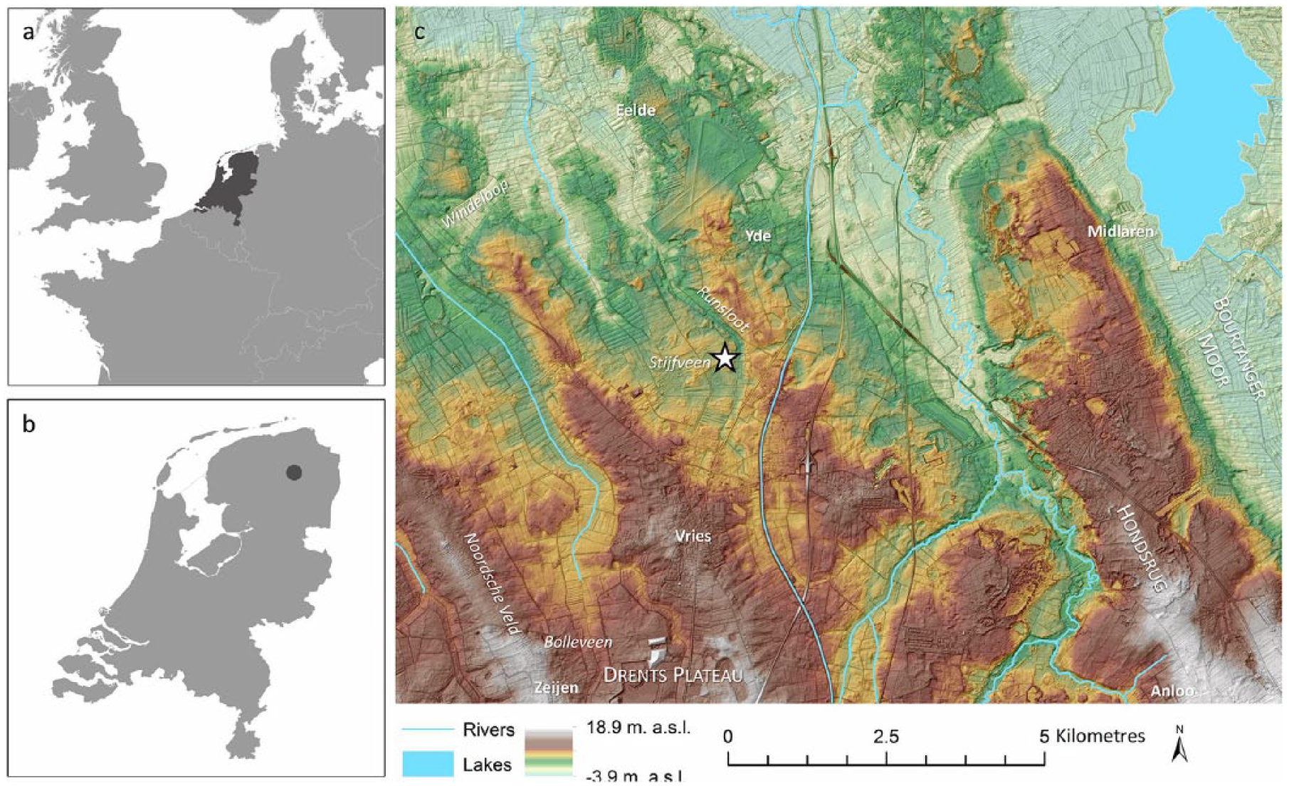
Site location of Yde Girl. Visible are (a) the location of the Netherlands within Europe, (b) the location of Yde within the Netherlands and (c) an elevation map of the wider study region (m. a.s.l. = metres above sea level, the hillshade effect has been exaggerated for visibility purposes). The findspot of Yde Girl is indicated with a star. The topographic names in (c) are referred to throughout the text. Digital elevation model (AHN2, horizontal resolution 5 m, vertical resolution 0.2 m): AHN (2018) and Van Heerd et al. (2000).
Theoretical background
The study of archaeological finds from bogs has a long research history that is partly linked to peatland reclamation history. Numerous finds have come to light over the past centuries, only a fraction of which have been registered and analyzed professionally. In some parts of Europe, such as the Irish Midlands and the United Kingdom, peat is still being extracted, leading to frequent new discoveries (e.g. Plunkett et al., 2009). In others, such as The Netherlands, peat-cutting has ceased many decades ago. The excellent preservation of organic materials, unparalleled in dryland environments, and the spectacular character of many bog finds, has made them fascinating and desirable research subjects. This scientific attention has resulted in a main focus on material culture and on individual sites, and to a very limited degree on context and wider settings. With regard to bog bodies forensic analyses have been dominant (Chapman, 2015). Nevertheless, some important exceptions can be mentioned. A small number of multidisciplinary studies have focused on the palaeoenvironmental analysis of individual sites, most notably at Lindow (United Kingdom; Stead et al., 1986; Turner and Scaife, 1995), Old Croghan (Ireland; Plunkett et al., 2009), Tumbeagh (Ireland; Bermingham and Delaney, 2005) and Uchte (Germany; Bauerochse et al., 2018). Furthermore, various regional overview studies of bog bodies are available (e.g. Burmeister, 2013; Hesse et al., 2010; Ravn, 2010, 2011; Van der Sanden, 1996). Some of these contain limited information on their landscape setting. However, studies integrating detailed archaeological data (especially on the character of the cultural landscape) and high-resolution geo(morpho)logical and palaeoecological evidence are lacking.
Bogs are frequently described as remote, hostile and dangerous places for (pre)historic people. However, the contrary was probably true. There are many indications that they were intrinsic components of settlement territories that were consequently interacted with – both in profane and ‘sacred’ ways (e.g. Murphy and French, 1988). They were accessed, exploited, modified and structured by humans, and – judging from the numerous special archaeological finds they have yielded – perceived as meaningful places. In the Netherlands, the economic use of peatlands (e.g. for pasture or peat-cutting) before the Middle Ages is difficult to assess, mainly because the large majority (up to 95%) of these areas had already been reclaimed at an early stage (Van Beek et al., 2015c). However, various finds of bog trackways, for example, demonstrate that they were already entered since Neolithic times (Casparie, 1987).
The importance of ‘natural’ places for prehistoric and early historic communities has repeatedly been stressed (Bradley, 2000). The notion that wetlands were frequently used for deliberate deposition of carefully selected objects, and that these practices had ritual motives, is generally accepted in archaeological circles. These deliberate actions are corroborated by clear patterning in the finds, described as ‘selective deposition’: specific types of objects always appear in specific landscape types (e.g. Fontijn, 2002; Needham, 1988). Prehistoric wooden disc wheels, for example, appear in the Netherlands only in bogs, while Iron Age swords are generally found in large rivers. This suggests that specific parts of wetlands were used time and again for the intentional deposition of objects, in some cases stretching several millennia. Moreover, the selection of objects shifted over time (Fontijn, 2007). The persistence of this practice indicates the continuing importance of wetlands in prehistoric and early historic belief systems.
As demonstrated by Brück (1999), archaeologists have the tendency to distinguish ritual from secular action, which leads to a misapprehension of prehistoric rationality. In reality, both were probably intricately interwoven. This is one of the reasons why making distinctions between wetlands (serving ‘ritual’ purposes) and drylands (‘profane’ use) are not useful if we really want to gain an understanding of past deposition practices – including those of bog bodies. Furthermore, as we are dealing with millennia-long traditions appearing in vast areas, we need to anticipate that underlying motives and meanings may have been diverse and dynamic through time. Single interpretations and generalizations probably do not suffice. These observations all point to the pressing need for thorough research on landscape contexts to make progress. It is our conviction that this can only be achieved by tailor-made interdisciplinary research designs, by not only looking beyond the boundaries between wetlands and drylands but also between humanities and environmental sciences.
Introducing Yde Girl: A concise research history
The discovery of Yde Girl (Figure 2a) has been described in detail by Van der Sanden (1990: 81–83; 1994). She was found on 12 May 1897 by two labourers in a small bog south of the village of Yde. The bog body surfaced when they were extracting peat using dredging poles, at a depth of approximately 1 m. She probably lay face down in the bog. The body and associated remains were hidden underneath heath sods for over a week before they were retrieved by the village mayor and a representative of the Provincial Museum of Drenthe. In the meantime, curious villagers had caused significant damage to the find.
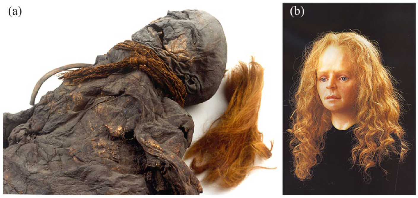
The bog body of Yde Girl in her current state (a) and the facial reconstruction (b) made by Richard Neave at Manchester University (photo courtesy Drents Museum, Assen, the Netherlands).
Compared to other Dutch bog bodies, Yde Girl has been studied intensively. Furthermore, she gained worldwide fame when her face was reconstructed at Manchester University in 1994 (Figure 2b). The remains that were found belong to an approximately 16-year-old girl with long hair, the right half of which was cut off. She was dressed in a heavily worn woollen cloak. A braided woollen cord or sprang with a sliding knot around her neck was probably used to strangle her. The girl’s body was 14C-dated in Oxford and Groningen, using samples of her skin (OxA-1724, 1980 ± 80 14C a BP), hair (GrA-9201, 1960 ± 50 14C a BP), woollen cloak (GrA-14178, 1970 ± 35 14C a BP) and the woollen sprang (GrA-14176, 2015 ± 30 14C a BP) (Van der Plicht et al., 2004). We have combined and calibrated these four dates with OxCal (version 4.3) using the R_combine function and IntCal13 calibration curve (Bronk Ramsey, 2009; Reimer et al., 2013). The resulting estimated age lies between 42 cal. BC and 59 cal. AD (95.4% confidence interval). In Dutch archaeological chronology, this date overlaps with the transition phase from the late Iron Age to the early Roman Period.
The findspot of Yde Girl has previously been reconstructed based on a combination of written documents, cartographic evidence and oral history (Van der Sanden, 1990, 1994). Topographic maps from around the time of discovery show various T-shaped and right-angled peat reclamation pits scattered over a large heath area, indicating a non-organized reclamation pattern, probably catering for local needs (Figure 3). The girl was probably found in the most northeastern pit, north of the peatland area called ‘Stijfveen’ and not far from the small Runsloot valley. From the late 1920s onward, the surrounding environment was gradually turned into agricultural land. During land consolidation measures and levelling activities in the 1970s, the peat reclamation pit was filled in and a field ditch was dug through its centre. Since that time the site has been in use as arable land. The location of the former bog is nowadays still clearly visible as a slight depression. In 1995, students of Groningen University conducted a small-scale coring research (Bandel et al., 1995), and Bottema (1995) performed a palynological quick scan on retrieved sediments. They concluded that the in-filled depression had a maximal depth of 1.8 m. In situ peat at the bottom of the depression was interpreted to be of Late Glacial and/or Early Holocene age. Unfortunately, both reports are very concise and the raw data could not be retrieved. In 2010, a monument was erected close to the site in memory of Yde Girl.
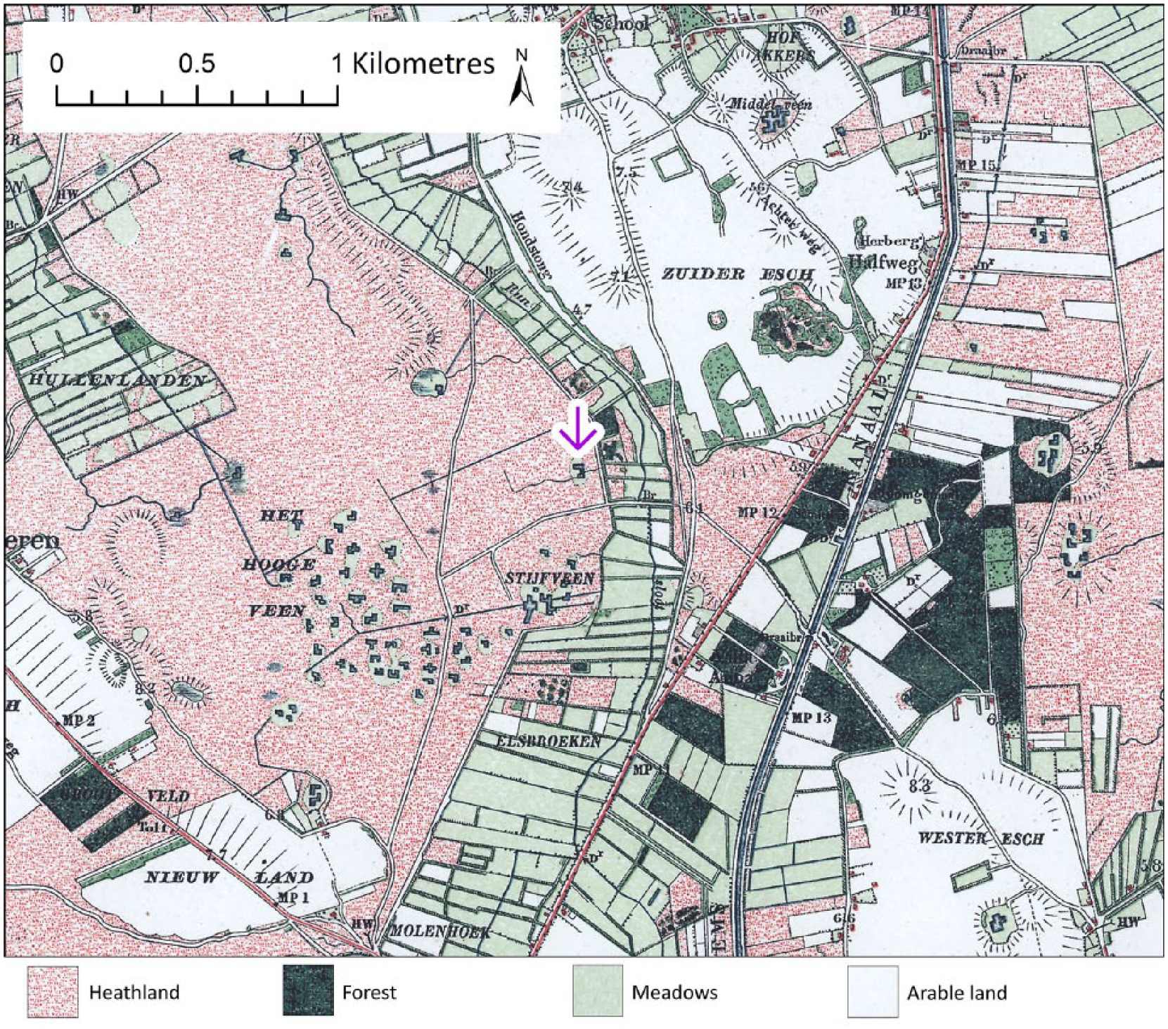
Topographical map of the environment of Yde ca. 1905 AD. The girl was most likely found in the peat extraction pit marked with the arrow. Image reference CC-BY 2018, Kadaster.
Methods and materials
Spatial research levels
Our research has centred on two different spatial scales. The first spatial research level is the findspot of Yde Girl itself. The work on this local level has focused on the former depression in which the girl was found and its direct vicinity (in total an area of 200 m x 200 m). The main research goal on this spatial level was to reconstruct the character of the local landscape at the time of the deposition of Yde Girl. The second scale, described here as ‘wider study area’, measures about 14 km x 11 km. The work on this spatial scale served to produce insights into the wider physical and cultural landscape setting. The size and position of this wider study area, with the findspot situated approximately at its centre, are determined based on geomorphological and archaeological data. The selected area offers a representative view of the geomorphological structure of the northern part of the province of Drenthe, as the most important geomorphological landforms are all represented. In addition, a significant number of archaeological sites (dated to the period under study) are known from this region. These sites offer detailed insights into habitation and land use patterns, and therefore into the character of the cultural landscape during the lifetime of Yde Girl.
Local research level
Ground-penetrating radar
Ground-penetrating radar (GPR) was used to create a detailed subsurface image of the depression. Although the use of GPR in peatlands is not optimal due to the high water content (Theimer et al., 1994), previous studies showed that subsurface structures (e.g. palaeochannels) can sometimes still be recognized (e.g. Candel et al., 2017). GPR measurements were conducted with a pulseEKKO PRO 500 Hz with a SmartTow configuration. The electromagnetic-wave velocity was derived from the corings (see below), and was ca. 0.052 m ns−1. Our analyses covered the entire depression as visible from the present-day digital elevation model (DEM), and the two fields that surround the depression.
Corings
Corings were performed in four transects crossing the depression. A gouge auger (Ø: 3 cm) was used for peat, an Edelman auger for unsaturated sand and a Van der Staay suction corer (Van de Meene et al., 1979) for saturated sand. In total, 27 corings were performed to a maximum depth of 4.7 m. Two additional corings were performed along both sides of a nearby stream (Runsloot). The location and surface elevation of each coring site was determined using a GPS combined with the national DEM (Van Heerd et al., 2000). The sediment cores were described in 10-cm-thick intervals, using the Dutch texture classification scheme (Berendsen and Stouthamer, 2001; De Bakker and Schelling, 1966). The median sediment grain size of non-organic, sandy samples was visually checked in the field by comparison with a sand ruler. In addition, plant macro-remains, beddings and colour were described. The results are presented as a palaeoDEM of the bottom of the depression and through a lithological and geologically interpreted cross-section combined with a GPR cross-section. The palaeoDEM was created for an area of 200 m x 200 m, based on elevation values of the palaeosurface as derived from the corings and present-day elevation values derived from the DEM for the surrounding area. Using ArcMap 10.5, the data points were interpolated to a raster with 5 m resolution using Inverse Distance Weighting. The ditch and elevated road nearby were removed prior to interpolation.
Palaeoecological analysis
Due to the peat extraction activities and later anthropogenic disturbances (land reallotment, levelling), the depression does not contain a peat fill covering the late Iron Age and early Roman Period anymore. In addition, corings in the nearby Runsloot valley did not produce suitable sediment for palaeoecological analysis for reconstructing the local vegetation. However, peaty sediments from the site have been palynologically analyzed during two different investigations in the past. These data, and most notably a peat sample from the foot of the bog body that was studied by Van Zeist (1956), were reinterpreted for the present study.
Archaeology
The parcels in which the depression is situated have – besides the bog body – not produced any archaeological finds in the past. No archaeological finds were done at the surface of these fields during the geomorphological fieldwork, apart from small quantities of post-medieval find material.
Wider study area
Geomorphological mapping
A detailed geomorphological map of the wider study area (11 km x 14 km) was compiled. Main data sources used for mapping were the Geomorphological Map of the Netherlands, scale 1:50 000, the Soil Map of the Netherlands, scale 1:50 000 (both at https://www.pdok.nl), the physical-geographical map of Spek et al. (2015), which covers parts of the study area, and the national LIDAR data (Van Heerd et al., 2000). The legend of the produced map (scale 1:50 000) closely matches the legend of the Geomorphological Map of the Netherlands. The mapping procedure involved an interpretation, and partly re-interpretation, of the above-mentioned data sources in a geographic information systems (GIS) environment.
Palaeoecology
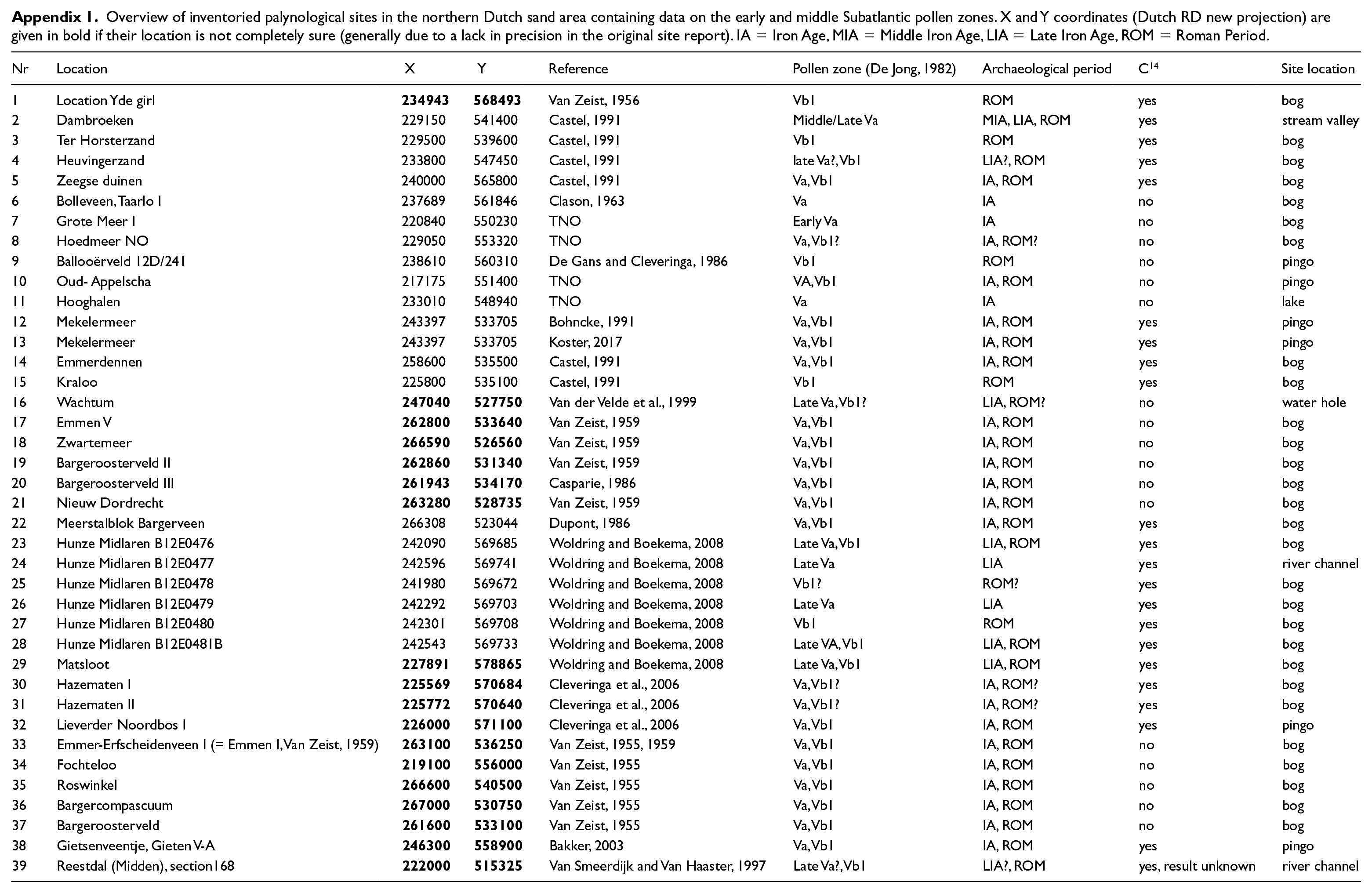
A map was made of the vegetation composition of the wider study area in the late Iron Age and early Roman Period. The basis of this reconstruction was formed by an inventory of existing palynological data, including both sites from the study area itself and its surroundings. The data are derived from published literature and palynological archives. In addition, various research institutes and universities were contacted. The late Iron Age/ early Roman Period encompasses the pollen zones early and middle Subatlantic (pollen zones Va and Vb1, De Jong, 1982; Donders et al., 2010). Only pollen data including this specific time period were collected. In total, 39 relevant palynological sites were found (Appendix 1). Only eight of these are located in the study area itself. The other sites were included because of their proximity to the region (maximally 50 km away from the findspot, but mostly closer) and their location in comparable landscape settings (sensu Van Beek et al., 2015a). Most data are derived from lakes, bogs and residual channels, especially from the areas to the west and south of the Yde region.
Despite the large amount of available pollen data, a substantial part is not suitable for use in recent models designed for vegetation reconstruction (e.g. Bunting and Middleton, 2005; Gaillard et al., 2008, 2010; Nielsen et al., 2012; Sugita, 2007a, 2007b). Most models require uniform data (with regard to pollen sums) from large lakes or mires, while our data originates from a large variety of sources. In addition, the original count data often were not available. Therefore, a different approach was chosen. We used a method developed by Van Beek et al. (2015a, 2015b) that incorporates all types of palynological data to identify regional trends and differences in vegetation development and land use. The method is based on the inherent relationship between the abiotic landscape, vegetation development and human activities, assuming that these relations are consistent in a relatively uniform area. Therefore vegetation – landscape relations (i.e. what type of vegetation community is present on which landscape unit) derived from single sites can be used to convert landscape units to vegetation communities in other areas outside of the direct surrounding of palynological sites. For more detail on the method, see Van Beek et al. (2015a).
For the vegetation reconstruction of the wider study area around Yde, the new geomorphological map (see above) was used to obtain information on the abiotic landscape. Additional information on nutrient status of the soils was obtained from the Soil Map of the Netherlands, scale 1:50,000 (at https://www.pdok.nl).
Archaeology
The cultural landscape during the lifetime of Yde Girl was reconstructed by means of a detailed inventory of archaeological sites. Northern Drenthe has always been part of the archaeological focal area of Groningen University. Therefore, a large number of archaeological sites is known and studied. Various sources were consulted, most notably the Dutch national archaeological database Archis III and published literature. The latter includes both older literature and the growing body of reports stemming from development-led archaeology. All sites dated to the Iron Age and Roman Period were registered in a database containing almost 200 sites, in which relevant information on site location, site character, date, material finds and literature was documented. The main categories are settlements, cemeteries, Celtic fields, cult sites and stray finds (e.g. single metal artefacts). Only the settlements of Midlaren-De Bloemert (Nicolay, 2008) and Eelde-Groote Veen (Tulp, 2014) have been subjected to large-scale excavations. A larger number of sites consist of small quantities of settlement refuse collected during field surveys. Most excavations of cemeteries (generally barrows) took place in the first half of the 20th century. Various Celtic fields have been detected by means of aerial photography (Brongers, 1976; Kooistra and Maas, 2008), but only the system of Zeijen-Noordse Veld has been studied in detail (e.g. Arnoldussen and Van der Linden, 2017; Spek et al., 2003).
Due to the frequent lack of precise dates some uncertainty remains regarding which settlements, cemeteries and votive sites were exactly in use in the narrow time frame between 42 cal. BC and 59 cal. AD. In our site plots, we have chosen to distinguish three phases: (1) early/middle Iron Age (800–250 BC), (2) late Iron Age/ early Roman Period (250 BC–AD 70) and (3) middle/late Roman Period (AD 70–400). In order to gain detailed insights in land use patterns over time it is important to use this wider temporal scope instead of just focusing on phase (2). Sites with imprecise dates and sites of which the exact character is unknown are indicated with specific symbols (e.g. as ‘possible’ settlements).
Results
Local research level
Geology and geomorphology
The elevation of the fields in which the depression is situated varies between 4.5 and 5.5 m above sea level (Figure 4). As mentioned above, the depression is clearly visible at the current surface. Our corings demonstrate that the former depression was ca. 2.3 m deep. The depression is rather symmetrical with a diameter of about 60 m, which is visible from the lithological and lithogenetic cross-section depicted in Figure 5a and b. Here, we shortly describe the geological units.
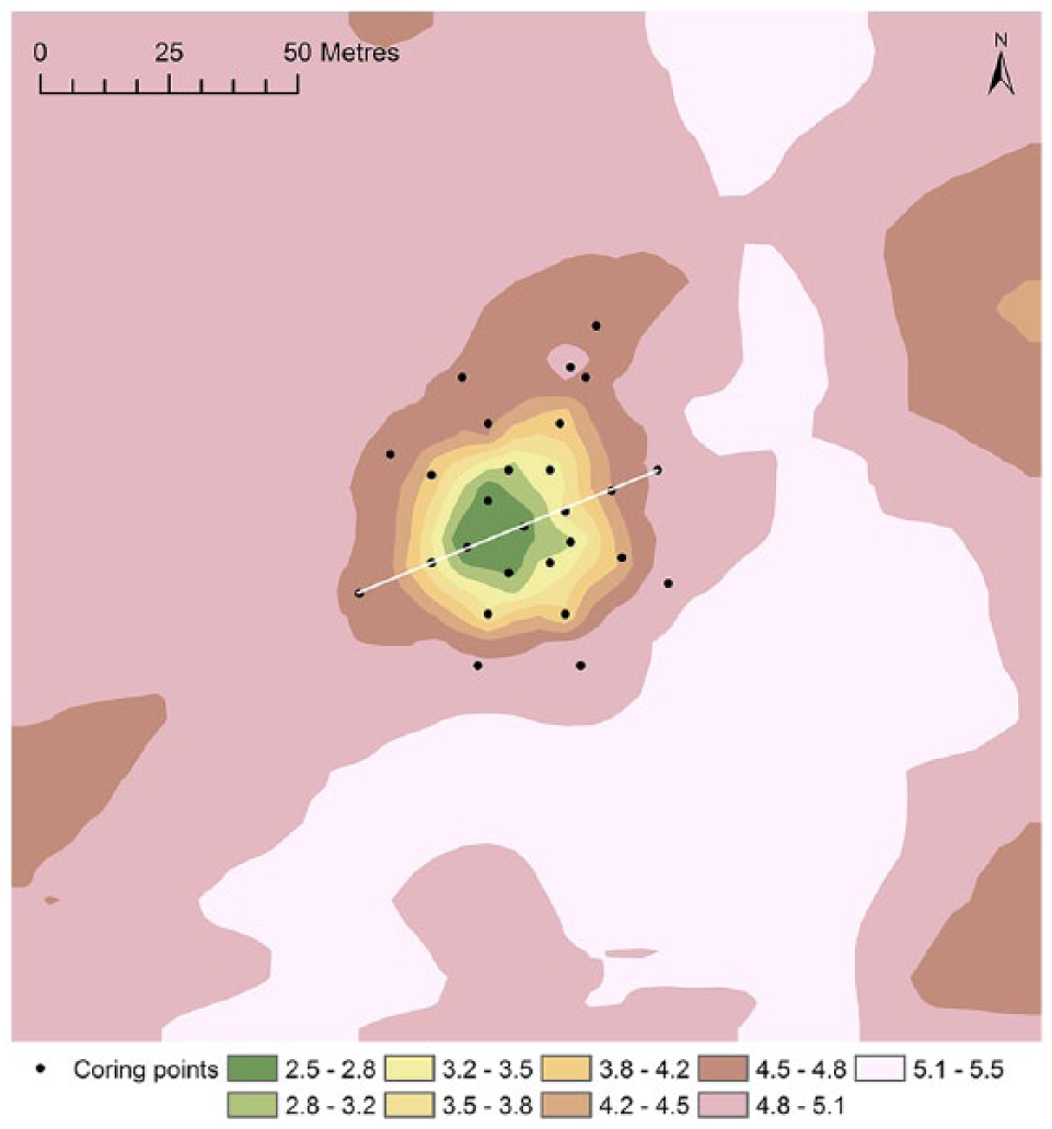
PalaeoDEM of the area (200 m x 200 m) around the topographic low where Yde Girl was found. Elevation is in metres above sea level, interpolation using Inverse Distance Weighting to a raster with 5 m x 5 m resolution. The white line shows the location of the transect in Figure 5.
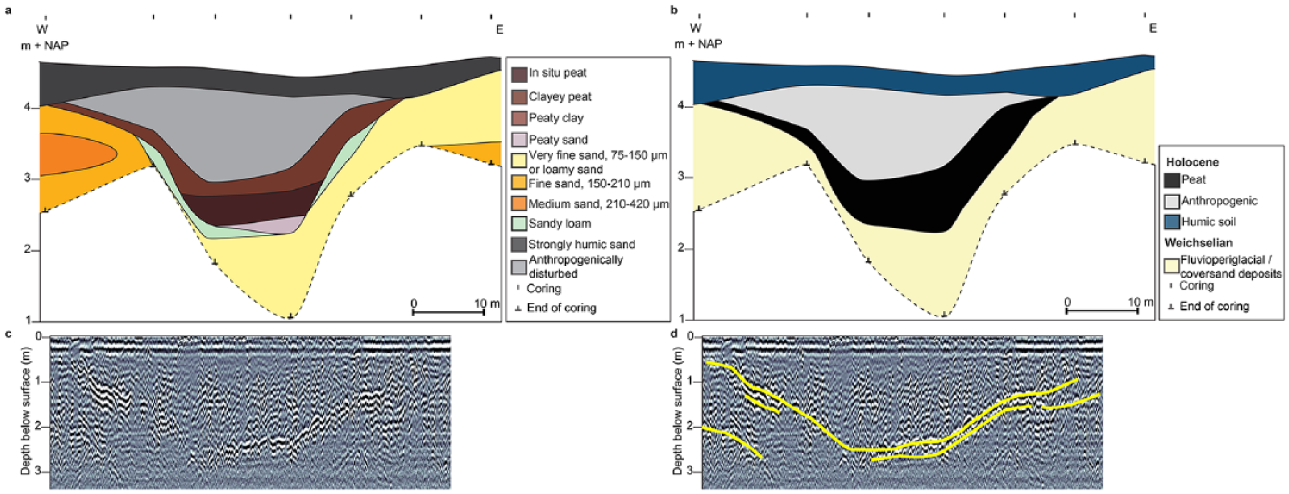
Subsurface data of the topographic depression, presented in a southwest to northeast transect (for location of the transect see Figure 4). (a) Lithological cross-section, (b) lithogenetic cross-section, (c) plain GPR cross-section, and (d) interpreted GPR cross-section.
The depression was delineated by Weichselian deposits, consisting of fluvioperiglacial sand and coversand. This unit consists of clastic sediment, varying from very fine to medium sand (75–420 µm), and is mostly well sorted. It may contain low percentages of loam (<10%) and up to 1% gravel. The unit is easily distinguishable from the other lithogenetic units by its bright light-grey colour, some thin soil formation, and sometimes a sharp transition to the other units. Plant remains are mostly absent. The base of the infill was formed by non-oxidized peat which was interpreted as being in situ. At the top this peat layer was partly oxidized, which resulted in a lack of macroremains. The peat layer was overlain by fine sands mixed with organic material, which was interpreted as an anthropogenic deposit. The latter is likely the result of surface levelling in the 1970s. In the top of these sandy sediments, a recent soil has developed, which is highly organic as a result of artificial fertilization.
Considering its symmetrical shape and its depth, the depression could be a fossil pingo dating from the Weichselian. In this period, the Drenthe Plateau was under permafrost conditions. According to De Gans and Sohl (1981), fossil pingos on the Drenthe Plateau generally have a depth between 2 and 17 m. However, fossil pingos in the nearby valley of the Drentsche Aa are generally characterized by a diameter of 150–200 m (De Gans, 1982). Furthermore, a rampart deposit would be expected in case of a fossil pingo. Whether such a deposit indeed was present cannot be determined due to the surface levelling activities. Therefore, the depression may also be a coversand depression; both landforms also date to the Weichselian and may have a similar shape. For our study, and specifically the reconstruction of the character of the depression in the late Iron Age/ early Roman Period, the distinction between a fossil pingo or coversand depression is not of major importance.
Corings on both sides of the Runsloot stream, situated within a few hundred metres east of the depression, indicated that a Holocene peaty valley-fill is absent. It probably did not contain a stream during the lifetime of Yde Girl, even though it may have been marshy at the time (see geomorphological map description). The rather straight stream that is currently present has probably been dug and appears relatively young.
Palaeoecology
Peat samples from the depression were palynologically analyzed during two different investigations in the past. Bottema (1995) investigated the peat at the base of the depression, which he (palynologically) dated in the second part of the late Glacial Allerød period. This, however, predates the deposition of Yde Girl. Van Zeist (1956) analyzed a peat sample collected from the foot of the bog body. His investigations showed that pollen of various tree and shrub species (mainly birch (Betula), oak (Quercus), hazel (Corylus avellana), alder (Alnus glutinosa) and pine (Pinus sylvestris)) as well as heather (Calluna vulgaris) and some upland herbs and cereals (Cerealia) was present. Obviously caution is necessary when interpreting these data, as the original stratigraphic context of the sample is unknown and pollution of the sample cannot be excluded. Nevertheless Van Zeist dated the pollen assemblage between 200–500 CE, which is not very far from the 14C-dates of the bog body that were only obtained at a later stage. Furthermore the presence of beech (Fagus sylvatica) and hornbeam (Carpinus betulus) suggests a Subatlantic age. This may indicate that the pollen spectrum obtained by Van Zeist provides at least some basic insights into the local vegetation around the time of deposition of Yde Girl. Based on the pollen spectrum, we interpret the site as an oligotrophic peat bog. Heather and some birches were present on drier parts of the bog as well as on its edges. In the direct surroundings of the bog, a mixed deciduous forest was probably present. High percentages of hazel indicate that this forest was relatively open. Some heather and grasses (Poaceae) grew in the area directly surrounding the site or in the undergrowth. Remnants of alder carr, some marshes and wet meadows on peaty soils may have been present in the small stream valleys surrounding the site (for example, in the present-day valley of the Runsloot). In the former village, probably some grass vegetation and ruderal terrain was present. Contrary to most pollen records obtained in the wider study area (see below), the pollen spectrum contained relatively high values of pine pollen. Pine was probably growing on the nutrient-poor soils to the south of the findspot. Low percentages of cereals indicate the presence of arable fields in the vicinity, probably on the well-drained higher ground moraine ridges northeast of the site.
Wider study area
Geomorphology and palaeogeography
The geomorphologically mapped wider study area (Figure 6) is largely part of the Drentsche Aa catchment, which developed in the Drenthe glacial till plateau. Only the northeastern corner of the study area, a peaty plain at the foot of the massive Hondsrug ground moraine ridge, is outside of this catchment and not part of the till plateau. The geomorphological structure of the Drentsche Aa catchment is formed by a series of NNE-SSE trended ground moraine ridges dating from the Saalian glacial period, when land ice covered the study area. The stream valleys of the northward draining Drentsche Aa system run between, and in places cut through, these ridges (De Gans, 1981). The ground moraine ridges typically rise up to 5 m above the valley floors and represent the highest geomorphological forms in the study area. They consist of sub-glacially deposited till and are fringed by lower forms, such as ground moraine bulges, plains and plateaus, ice-meltwater slopes, and low aeolian coversand ridges and plains. The aeolian coversand forms date from the Weichselian glacial period, when dry periglacial conditions dominated the study area. The valley floors in the study area commonly are 1–2 m below the neighbouring landforms, such as coversand or ground moraine plains. Variously sized, more or less rounded depressions occur scattered over the plains and plateaus throughout the study area. They represent fossil pingos or aeolian deflation basins, both of Weichselian age. Rising regional groundwater levels in the Holocene caused peat formation in the deeper valleys of the Drentsche Aa system (Spek et al., 2015). In addition, many of the depressions became filled by gyttja and peat. During the Holocene, a peat cover expanded from the depressions and valleys across the poorly drained plains. Due to improved drainage of the landscape for agricultural development much peat has disappeared because of oxidation during the 20th century. On the geomorphological map (Figure 6) areas with a potential former peat cover are indicated with purple dots. In the period under study, peat cover in the area was probably near its maximum extent.
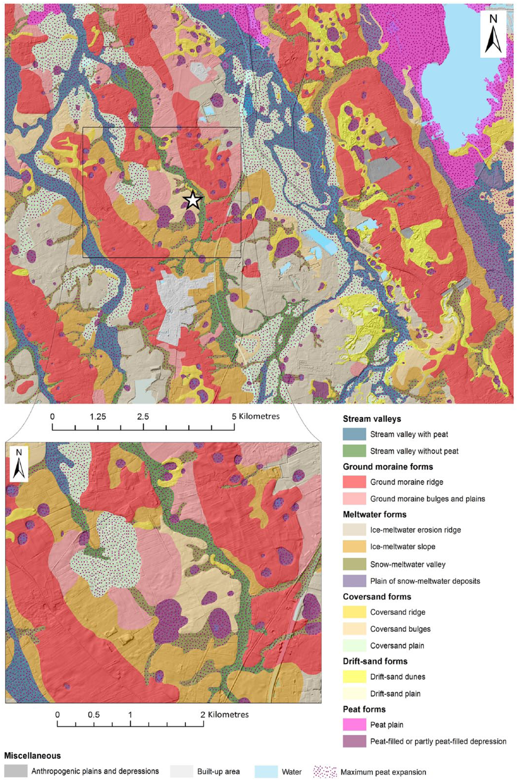
Geomorphological map of the wider study area. The area around the Yde Girl site (indicated with a star) is depicted in more detail in the inset below.
The Yde Girl site is located in a relatively small peat-filled depression within a coversand plain with low-relief bulges (Figure 6). A larger peat-filled depression occurs west of the Yde site in this coversand unit, whereas some much larger peat-filled depressions occur near its edges to the south and the southwest. From these depressions, peat has been extracted around 1900 AD (see extraction pits in Figure 3). The coversand unit is bordered by low terrain, predominantly valleys, to the south, the east and the north. Low-lying, relatively wet, geomorphological units, that must have been unsuitable for habitation, extend to the south, west, and northwest for at least one kilometre. The Runsloot valley (~100 m wide) east of the Yde Girl site may have been peaty in the past, but nowadays peat is absent in the soil profile that only has a humic topsoil. A former peat-fill, if present, must have been thin (e.g. <1 m). The valley is connected to the Drentsche Aa valley system, but this does not imply that it hosted a stream in prehistoric Holocene times. Most of the smaller valleys in the Drentsche Aa system originally lacked a stream and were dominated by marshes with slow non-channelized water flow (Candel et al., 2017; Spek et al., 2015). These small valleys are the most upstream branches of the Drentsche Aa valley system and presumably were formed by sub-glacial ice-meltwater flows in the Saalian. On the other side of the valley, mainly northeast of the Yde Girl site, a relatively large ground moraine ridge rises several metres above the surrounding geomorphological units. This ridge hosts the present-day village of Yde surrounded by old arable fields.
Palaeoecology
The distribution of the 39 collected pollen sites is depicted in Figure 7. Using the established links between vegetation units and landscape units (Table 1), the geomorphological map of the wider study area was converted into the vegetation map (Figure 8).
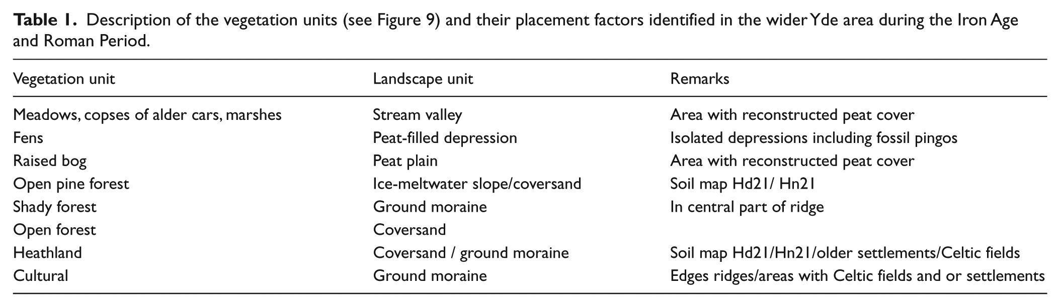
Description of the vegetation units (see Figure 9) and their placement factors identified in the wider Yde area during the Iron Age and Roman Period.
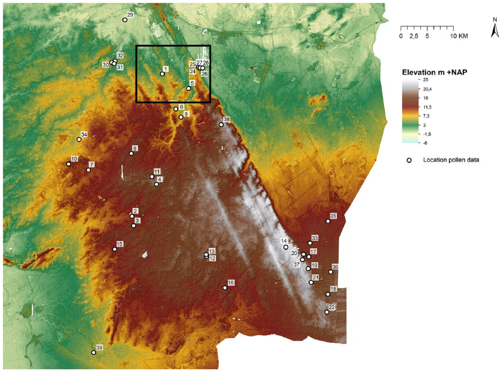
Distribution of palynological sampling sites in the northern Dutch sand area containing information on the early and middle Subatlantic (pollen zones Va and Vb1; Iron Age and Roman Period). The area we refer to as ‘wider study area’, is indicated with a black rectangle. The numbers refer to the pollen sites listed in Appendix 1.
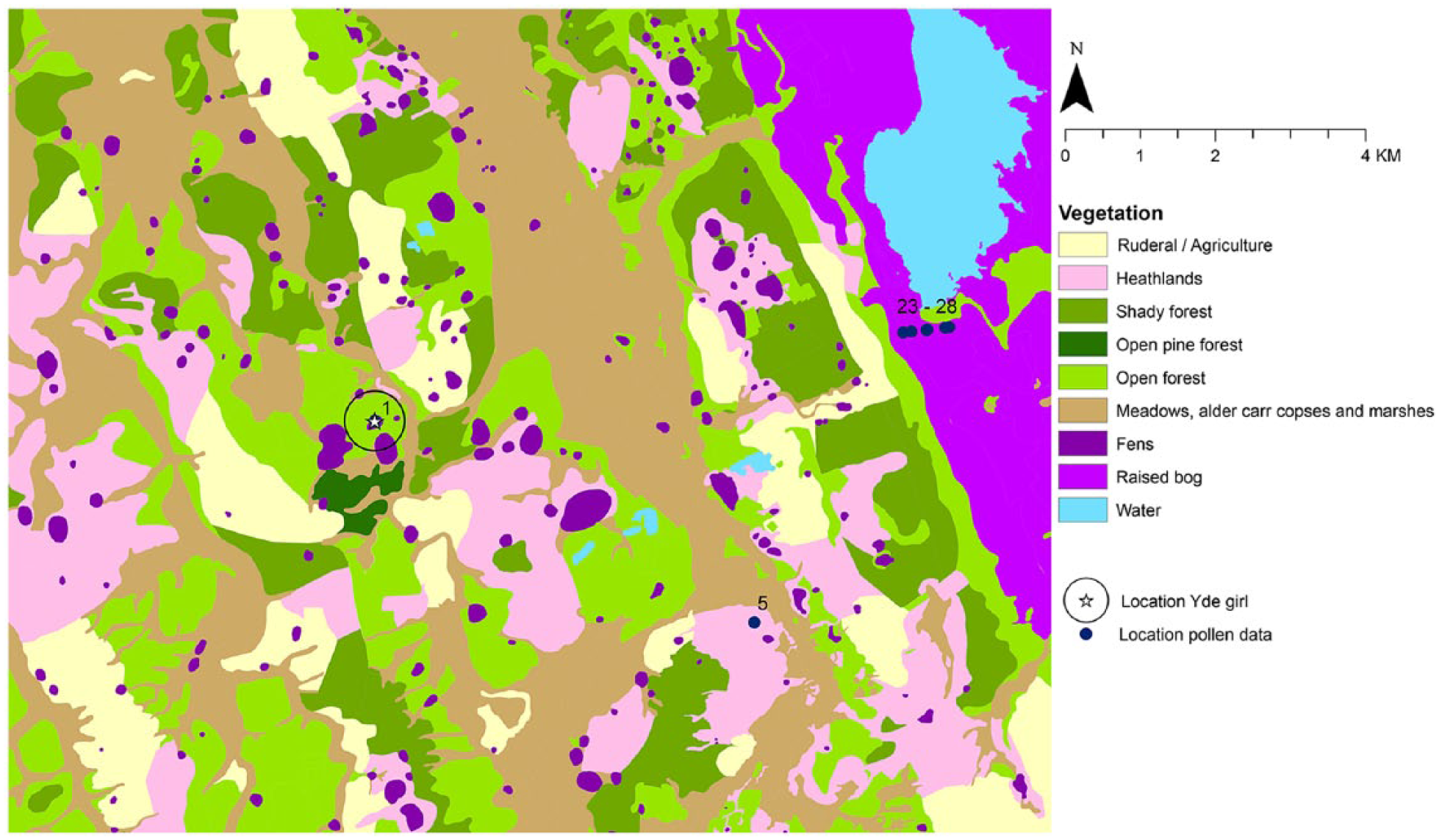
Vegetation map of the wider study region around Yde.
Most pollen diagrams (Appendix 1) covering the early and middle Subatlantic (pollen zones Va and Vb1, De Jong, 1982; Donders et al., 2010) demonstrate a decrease in arboreal pollen and an increase in heather and grasses. This trend is combined with the appearance of cereal pollen, arable weeds and other anthropogenic indicators. The pollen data thus indicate that the landscape was already heavily influenced by humans and relatively open. Much of the original forest cover had already disappeared. Almost all pollen diagrams show very low values of pine, demonstrating that pine forests were almost absent. The high pine values in the Yde peat sample analyzed by Van Zeist (1956) may suggest that a small remnant of open pine forest had survived just south of the Yde Girl site. Pine, in general, is often found on nutrient-poor soils.
The nutrient-rich soils of the ground moraines were partly covered with shady forests consisting of oak, beech and hornbeam. Beech and hornbeam expanded in the Iron Age and Roman Period, often at the cost of lime (Tilia). The decrease in lime during this period can, however, also be related to the increase in human impact as the branches of deciduous trees, like lime, were often used as cattle fodder (Van Zeist, 1959). Open, mixed deciduous forests with abundant hazel developed on the slopes. These open forests grew on less rich soils. Hazel and grasses were present on open places in the undergrowth and at forest edges. During the Iron Age and Roman Period, many forests on the ground moraines – most notably the Hondsrug (Woldring and Boekema, 2008) – were cleared and replaced by agricultural fields. Some shady forest remnants remained, but they were probably interspersed with large open spaces and arable fields. The location of these fields, where cereals were grown, shifted over time with some fields left barren or abandoned. The composite unit ‘cultural’ indicated on the map consists of a combination of active and abandoned arable fields, ruderal terrains and settlements. Heathlands developed on poor sandy soils, and on abandoned agricultural fields on the ground moraines. The elevated ridges in this period therefore show a mix of different vegetation types; active or abandoned agricultural fields (Celtic fields during the Iron Age) intermixed with heathlands and shady forests consisting of oak, beech, hornbeam and little lime.
The part of the Bourtanger Moor that is part of the study area, east of the Hondsrug, was characterized by raised bog vegetation. At the edges of this raised bog and on the eastern lower slope of the Hondsrug, peat vegetation with bog myrtle (Myrica gale) was present (Woldring and Boekema, 2008). Bog myrtle probably formed an important element in the peat vegetation during the Iron Age and Roman Period in this area (Cleveringa et al., 2006). Although its pollen is not always recognized (it can be confused with hazel pollen) the species is often well represented in the pollen diagrams dating from this period.
Fens developed in fossil pingos or other shallow depressions. During the Iron Age and Roman Period, the larger ones (e.g. Mekelermeer; Appendix 1) were still lakes, but most of these depressions were already largely filled-in with peat (i.e. Ballooërveld 12D/241, Oud-Appelscha, Lieverder Noordbos I and Gietsenveentje, Appendix 1). Some of these depressions were fringed by birch and/or bog myrtle or covered by heather.
In the stream valleys, much of the originally present alder carr vegetation was replaced by meadows – probably due to human clearances – and peat bogs. However, some alder carr remnants were probably still present in wet habitats and single trees were probably growing on the margins of peat bogs. On the transition between heathlands and stream valleys, peatlands with bog myrtle were present. In most pollen diagrams collected from peat bogs, grasses reach relatively low values. Only in or nearby stream valleys (e.g. Ballooërveld 12D/241, Emmerdennen, Hazematen I and II and Reestdal-168, Appendix 1), high Poaceae values are recorded. This suggests that meadows with grass vegetation during this period were mainly restricted to the stream valleys.
Archaeology
The archaeological site distribution patterns (Figure 9) demonstrate that the ground moraine ridges were the preferred habitation areas throughout the Iron Age and Roman Period. Especially the Hondsrug and the ground moraine ridge at Zeijen, in the southwest of the wider study area, demonstrate a relatively high site density. Several Neolithic and Bronze Age sites are known from ground moraine ridges as well (e.g. Jager, 2015). These landscape units were highly suitable for agriculture (see below). The meadows in adjacent stream valleys as well as nearby heathlands could be utilized for pasture.
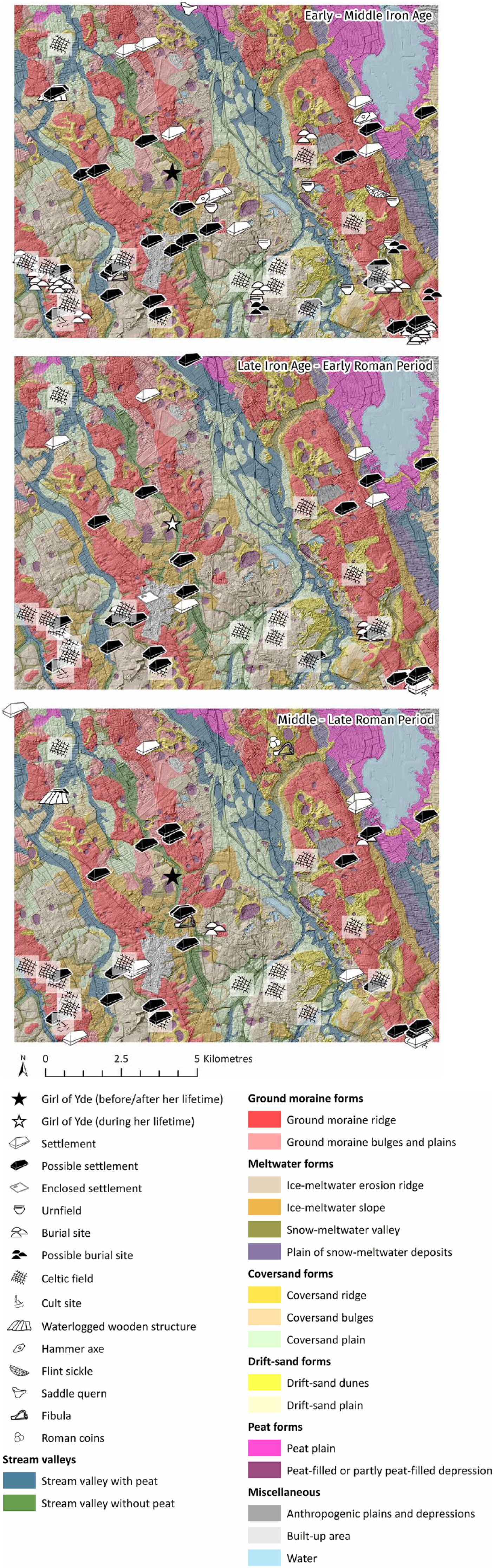
Distribution patterns of archaeological sites dated to the early/middle Iron Age (800–250 BC; top), late Iron Age/early Roman Period (250 BC–AD 70; middle) and middle/late Roman Period (AD 70–400; below). During the latter phase (and perhaps even earlier), the Celtic fields will gradually have fallen into disuse.
The three site distribution plots do not indicate major transformations in site location through time. Most sites are dated to the early and middle Iron Age. This is the longest period, and sites from this phase – especially urnfields – are fairly well recognizable. This may explain their prominence in the dataset.
The direct vicinity of the small bog where Yde Girl was deposited was probably not suitable for permanent habitation. Even nowadays, the arable fields around the site are quite wet despite the recent artificial lowering of the water table for agriculture. However, various possible settlement sites are known within a distance of just 1 or 2 km. If the girl was of local origin (see discussion), she may well have lived in a nearby settlement on the ground moraine ridge to the northeast of the site. Kuijer (1991: 32) reports a prehistoric agricultural layer containing charcoal and shards in the soils of the large arable field south of Yde (locally known as ‘Zuideresch’). These are not dated precisely, but may indicate the presence of a settlement that was inhabited during the lifetime of Yde Girl. The predecessors of historical villages in Drenthe are often found underneath their open fields underlining their persistence (Waterbolk, 1995).
Archaeological data from the province of Drenthe demonstrate that Iron Age and early Roman Period settlements generally consisted of 1–3 farmsteads and shifted over small distances regularly. The middle and late Roman Period on average show a slight increase in settlement size (4–6 contemporary farmsteads) and a larger site continuity, but smaller settlements still occurred as well (Van Es, 1990; Waterbolk, 1995). The sites of Midlaren-De Bloemert and Eelde-Groote Veen, excavated in our study area (Nicolay, 2008; Tulp, 2014), fit this general image of small settlements well. Not much burial data are available from the wider study area. Evidence from other parts of Drenthe suggests that cremation cemeteries, generally not containing more than a few dozen burials, were the norm until the late Roman Period (e.g. Van Es, 1990). These cemeteries were situated within a few hundred metres distance of the settlements.
A remarkable site category is formed by three famous ‘walled enclosures’, two of which were excavated in Zeijen (Figure 10) and one in Vries (e.g. Van Es, 1990; Waterbolk, 1977, 1995). These sites are rather exceptional in Dutch archaeology. They contain small numbers of farmsteads and outbuildings surrounded by complex systems of palisades, banks and ditches. They are dated to the late Iron Age and early Roman Period and were therefore in use during the lifetime of Yde Girl. The function of these sites is heavily debated (e.g. Van Es, 1990). Proposed interpretations are central places, market sites, agricultural stock sites and ritual centres. It has been suggested that these walled enclosure indicate some degree of societal unrest (Van der Sanden, 2018). Nevertheless the small site size and character of the defence systems (especially compared to the hillforts and oppida that are known from other parts of Northwest Europe) make an actual use as fortifications highly doubtful. A symbolic function seems more plausible.
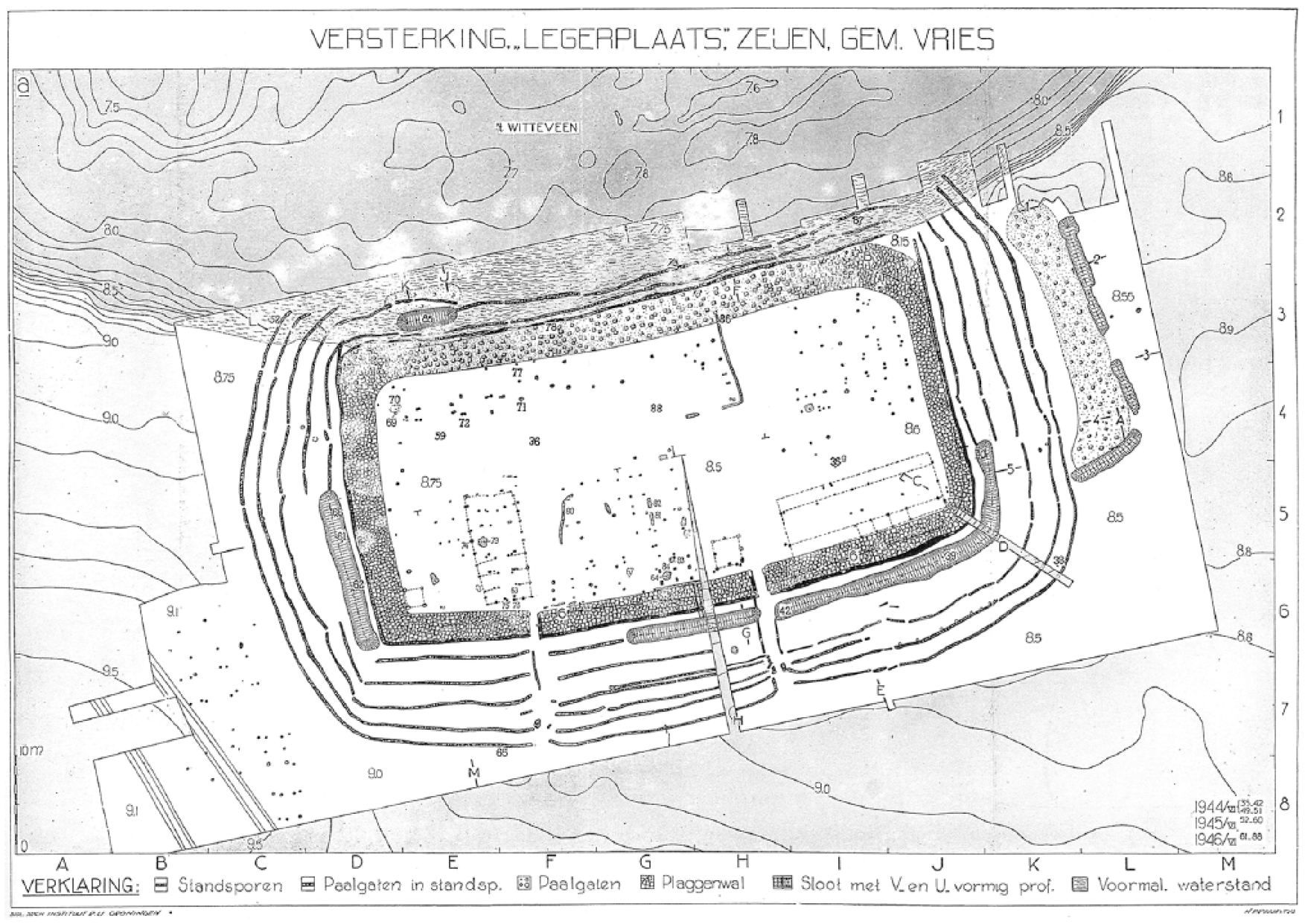
Walled enclosure excavated at Zeijen (for location see Figure 1). Because the site, which measures about 90 m x 50 m, was modified repeatedly the depicted features may date from different use phases. Reproduced from Van Giffen (1950), Figure 9.
Various Celtic fields are known from the wider study area, some of which are clearly visible on the LIDAR imagery (Figure 11). They appear almost exclusively on ground moraine ridges, mainly in the southern part of the wider study area. This site location testifies to the agricultural suitability of ground moraine ridges, which possessed a favourable moisture balance under well-drained conditions and a good natural fertility. Celtic fields, consisting of large complexes of earthen banks delineating square field plots, developed over the course of many centuries. They probably appeared from the late Bronze Age onwards (Spek et al., 2003). Whether all of these field systems were still in use when Yde Girl lived is uncertain. Most researchers assume the practice of Celtic field agriculture disappeared around the start of the Roman Period (e.g. Spek et al., 2003). In many cases, the ground moraines remained in agricultural use until today, which in some cases – possibly at the open field of Yde as well – may have erased late prehistoric field systems.
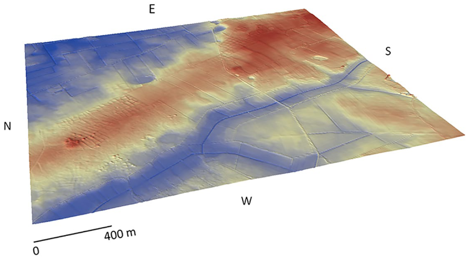
LIDAR image of the moraine ridge of Zeijen (for location see Figure 1), showing an area of 2518 m (x-direction) x 2726.5 m (y-direction). For visibility reasons, the z-direction was exaggerated by a factor 5 (true elevation range 4.4–13.7 m above sea level). Clearly visible are the Celtic field systems that occupy significant parts of the ridge, as well as several clusters of barrows. Most of the latter pre-date the Iron Age. Digital elevation model (AHN2, horizontal resolution 5 m, vertical resolution 0.2 m): AHN (2018) and Van Heerd et al. (2000).
Both the pollen data and the archaeological site plots illustrate the significant human impact on the Iron Age and Roman-Period landscape in the wider study area. To get an impression of the population density during the lifetime of Yde Girl, we can refer to recent attempts to estimate late prehistoric and early historic settlement and population densities in different Dutch regions (summarized in Groenewoudt and van Lanen, 2018). These estimates are mainly based on archaeological settlement data. Estimates for various Dutch sandy areas between the late Iron Age and middle Roman Period vary between 2.5 and 5 persons/km2, and settlement densities between about 0.15 and 0.35 per km2. If we transfer these figures to our wider study area of 154 km2 (14 km x 11 km) – without assuming they are precise – this would imply a population of between 385–770 people, and a total of 23–54 settlements. Based on the observed settlement patterns (taking into account that some sites are still unknown) and landscape structure (with large areas being too wet for habitation) the lower end of these figures may be the most plausible.
Besides the Yde site, there are other indications for human use of wetlands in the wider study area. In the Windeloop valley in the north of the area, part of an early/middle Iron Age wooden structure was found. This may have been part of a trackway or platform (Van Hoof, 2015). Various single objects found in valleys and depressions probably represent votive depositions. Examples are three (possibly four) stone hammer axes, a saddle quern and a Roman fibula and coin. Most interesting, however, is the Bolleveen site (for location see Figure 1). In this small bog (diameter about 100 m), some middle or late Iron Age wooden wheel fragments were found during peat cutting in the first half of the 20th century. In addition, a large quantity of pottery and bone dated between the 1st and 5th century AD was retrieved (Van and Giffen, 1950, 1952). Furthermore, a number of stone, beehive-like constructions are reported to have stood on the bog surface. Reports that two bog bodies were found as well could not be substantiated (Van der Sanden, 1990). These finds probably indicate that the bog was used for ritual purposes for prolonged periods of time, possibly also during the lifetime of Yde Girl. The Bolleveen is situated on the moraine ridge of Zeijen, within close distance of a Celtic field and various other contemporary sites. As such it appears to have been fully incorporated in the cultural landscape. Throughout the study area, a number of single (relatively rare) finds in dryland contexts may also point to votive depositions, such as some flint sickles, a large La Tène fibula and a 2nd century CE silver coin hoard found near Anloo.
Judging from the archaeological data, the late Iron Age/early Roman Period landscape was very much anthropogenic. Especially the ground moraine ridges were dotted with small villages, cemeteries and large field systems. The various wetland areas were probably important both economically (e.g. as pasture) and sacrificially. The latter is indicated by the Yde and Bolleveen sites, as well as a series of single objects. The size and character of the social group involved in the deposition of Yde Girl are very difficult to assess. The archaeological data – both for the study area and Drenthe as a whole (e.g. Jager, 2015; Van Es, 1990; Waterbolk, 1995) – point to simple, egalitarian societies. As discussed above, population and settlement density were probably fairly low. Both settlements and cemeteries hardly show any evidence for status differences, there is no extreme wealth visible in deposition sites, and large central sites or fortifications (e.g. oppida) are lacking. At least some of these aspects were to be expected if the area was inhabited by highly complex, stratified societies. Based on these observations, it seems unlikely that decision-making on the (probably ritual) practices that took place at Yde happened at a regional level, or that very large groups of people attended. Our hypothesis would be that no more than a few nearby villages were involved (see below).
Discussion
The structure of the physical landscape during the lifetime of Yde Girl was a mosaic of high, but fragmented, ground moraine ridges, surrounded by lower, often peaty, plains and stream valleys. The well-drained higher ground moraine ridges were by far the most suitable places for habitation, offering enough space and good soils. Connections between the settlements on the ground moraine ‘islands’ in the late Iron Age and early Roman Period must have been partly hampered by the wet surroundings, although generally less so in the NNE-SSE direction, because of the orientation of the ridges, than in the east-west direction. The vegetation composition of the wider study area can also be characterized as relatively open, diverse and heterogeneous. The landscape consisted of a mosaic of forest remnants, heathlands, alder carr copses, fens and mires interspersed with settlements, cemeteries and field systems. It was half-open and heavily affected by human activity, which is also clear from the archaeological data.
Based on the reconstructed palaeogeography around the Yde Girl site it is conjectured that the girl may have originated from a nearby settlement on the Yde ground moraine ridge. A similar hypothesis has also been put forward by Van der Sanden (2010b). From this settlement, the Yde Girl site was the nearest peaty depression outside the ground moraine ridge, with the narrow valley being the only obstacle on the route that was approximately 1 km long. The valley could be crossed relatively easily, as the firm sandy subsoil was only covered by a thin, maybe even insignificant, peaty topsoil. In dry periods crossing without aids, such as a wooden trackway, must have been possible. In wetter periods, a simple wooden structure, or even some fallen trees may have been sufficient to bridge the ca. 100 m across the valley. Other settlements in the late Iron Age and early Roman Period were probably at least 2 km from the Yde Girl site with much more uninhabited and wet terrains to be traversed. The palaeogeographical data thus suggest that Yde Girl was deposited at a site outside, but nearby, the inhabited domain, with the narrow and shallow valley as a clear, but easily passable, physical boundary between the deposition site and the inhabited domain. The selected deposition site itself was a small and relatively shallow oligotrophic peat bog within an open forest with heather and some birches on the drier parts. A small remnant of pine forest may have been present just south of the site.
The site location of Yde Girl may have a number of parallels in The Netherlands. One example is the slightly younger site of Zweeloo, where a bog body of an adult person dated to the Roman Period was found (Van der Sanden, 1990). The location (about 35 km south of the Yde Girl site) has not been investigated in detail, but the bog in question was comparatively small as well. On the other hand, we also know a series of finds from the vast Bourtanger Moor. Well-known sites in this area are Weerdinge, Weerdinger Aschbroeken, Emmer-Erfscheidenveen and Exloërmond, dated between the Bronze Age and Roman Period (Van der Plicht et al., 2004; Van der Sanden, 1990). The Bourtanger Moor is also known for various prehistoric wooden trackways, a Bronze Age ‘temple’ at Bargeroosterveld and numerous other archaeological finds that are generally interpreted as votive depositions (e.g. Van der Sanden, 2001). It is bordered to the west by the Hondsrug ground moraine ridge, which was the most important settlement area of Drenthe throughout prehistory and early history (e.g. Jager, 2015; Waterbolk, 1995). It also formed the main route for long-distance travel, trade and communication. Whether the bog body sites in the Bourtanger Moor (large bog bordered by an extensive moraine ridge, relatively ‘homogeneous’ landscape) should be interpreted differently than sites like Yde and Zweeloo (small bogs in more diverse, ‘heterogeneous’ landscapes) is difficult to assess (cf. Van der Sanden, 2010a). However, a thorough analysis of archaeological data from the Hondsrug-Bourtanger Moor area could provide key insights.
Based on absent evidence for status differences in burial and settlement data we concluded that the local late Iron Age and early Roman communities had an egalitarian nature. Interestingly, a similar image emerges from Classical sources. Tacitus, most notably, mentions the lack of strong hierarchy in the region south of our study area in the 1st century AD (Annals XIII, 54). In addition, in his Germania he broadly discusses the dispersed nature of settlement in the areas north of the Roman empire. The suggested egalitarian character of the communities in our study area gives the impression that the initiative for the deposition of Yde Girl was taken at a relatively low level, probably involving a modest number of nearby settlements. The main difficulty is in determining how society was structured and, related to that, which economic, cultural and ritual practices where carried out by which social group (cf. Van der Sanden, 1996). Social communities may be changeable in size and composition according to the specific context. Most daily tasks will have been performed on a household or settlement level. However, the size and lay-out of the Celtic field systems clearly demonstrate communication and cooperation between larger groups, probably consisting of the inhabitants of a number of settlements that used different parts of the field system at the same time. The remarkable ‘walled enclosures’ may represent the effort of a similar group, and the relatively small size of most late Iron Age and early Roman Period cemeteries in Drenthe indicates that they were used by a few settlements at most. The fact that the middle and late Iron Age wooden trackways in the Bourtanger Moor (Casparie, 1986, 1987), not very far to the east and southeast of our wider study, are between 3 and 12 km long, clearly points to joined efforts by larger groups of people as well. Nevertheless it is important to stress that cooperation between settlements does not necessarily point to a complex society or social stratification. It is possible that larger communities gathered for specific social and sacrificial events and that decision-making took place on a higher level, but currently there is no archaeological evidence to support that.
Whether Yde Girl indeed was of local origin is unknown. Interestingly, recent strontium isotope analyses of Haraldskær Woman (Denmark) have revealed a complex pattern. Even though she may have grown up in the area where she was found, there is evidence to suggest long distance movement before her death (Frei et al., 2015). Future strontium isotope research of other bog bodies and related finds such as textiles (e.g. Frei et al., 2009) could certainly shed more light on the life history of these individuals, on how these communities were connected to ‘the outside world’, and perhaps even contribute to gaining a better understanding on the motives behind the practice.
The interdisciplinary research undertaken in the present study has provided significant new insights into the landscape setting of one of the most iconic European bog bodies. Remarkably, research on this detail level has hardly been done yet. This mainly applies to the integration of different types of data in order to arrive at reconstructions of the holistic physical and cultural landscape at the type of deposition. Nevertheless we can make some comparisons with previous work. The bog bodies at Lindow Moss (United Kingdom), for example, appear to have been deposited in the least accessible part of the bog (Chapman, 2015). Unfortunately, less is known about contemporary habitation in the direct vicinity. Another fascinating case is Borremose (Denmark; Martens, 1994). Within this area, which is significantly smaller than our study region but rich in bogs, various striking finds were done. These include a remarkable stronghold that shows some similarities with the walled enclosures near Yde, three bog bodies and the famous Gundestrup cauldron, as well as various settlements, cemeteries and Celtic fields. In this case, we have less detailed insights into geomorphology or palaeoecology. Nevertheless, microregions like these clearly indicate that bog bodies should not be studied as isolated phenomena, as has been done in the past, but that their context is key to gain a more integrated understanding.
Conclusion
The interdisciplinary analysis presented in this study has demonstrated that the body of Yde Girl was left in a small and relatively shallow oligotrophic bog, not far from the inhabited domain. The structure of the physical landscape was a mosaic of high, but fragmented, ground moraine ridges, surrounded by lower, often peaty, plains and stream valleys. The vegetation had a mosaic character, consisting of forest remnants, heathlands, alder carr copses, fens and mires and was heavily affected by human activity. The cultural landscape consisted of dispersed farms and hamlets and associated cemeteries, cult sites, field systems and pasture, and three remarkable ‘walled enclosures’ that may have had a symbolic function. Absent evidence for status differences in burial and settlement data indicates that the society had an egalitarian nature. Combined with the selected deposition site-an inconspicuous, small and shallow bog-, this gives the impression that the initiative for the deposition of Yde Girl may have been taken at a relatively local level, probably involving a modest number of nearby settlements.
The results of the study demonstrate that interdisciplinary research designs can lead to valuable and comprehensive new insights into the physical and cultural context of bog bodies, and are necessary to move the bog body debate to a higher interpretative level.
Footnotes
Appendix
Overview of inventoried palynological sites in the northern Dutch sand area containing data on the early and middle Subatlantic pollen zones. X and Y coordinates (Dutch RD new projection) are given in bold if their location is not completely sure (generally due to a lack in precision in the original site report). IA = Iron Age, MIA = Middle Iron Age, LIA = Late Iron Age, ROM = Roman Period.
| Nr | Location | X | Y | Reference | Pollen zone (De Jong, 1982) | Archaeological period | C14 | Site location |
|---|---|---|---|---|---|---|---|---|
| 1 | Location Yde girl |
|
|
Van Zeist, 1956 | Vb1 | ROM | yes | bog |
| 2 | Dambroeken | 229150 | 541400 | Castel, 1991 | Middle/Late Va | MIA, LIA, ROM | yes | stream valley |
| 3 | Ter Horsterzand | 229500 | 539600 | Castel, 1991 | Vb1 | ROM | yes | bog |
| 4 | Heuvingerzand | 233800 | 547450 | Castel, 1991 | late Va?, Vb1 | LIA?, ROM | yes | bog |
| 5 | Zeegse duinen | 240000 | 565800 | Castel, 1991 | Va, Vb1 | IA, ROM | yes | bog |
| 6 | Bolleveen, Taarlo I | 237689 | 561846 | Clason, 1963 | Va | IA | no | bog |
| 7 | Grote Meer I | 220840 | 550230 | TNO | Early Va | IA | no | bog |
| 8 | Hoedmeer NO | 229050 | 553320 | TNO | Va, Vb1? | IA, ROM? | no | bog |
| 9 | Ballooërveld 12D/241 | 238610 | 560310 | De Gans and Cleveringa, 1986 | Vb1 | ROM | no | pingo |
| 10 | Oud- Appelscha | 217175 | 551400 | TNO | VA, Vb1 | IA, ROM | no | pingo |
| 11 | Hooghalen | 233010 | 548940 | TNO | Va | IA | no | lake |
| 12 | Mekelermeer | 243397 | 533705 | Bohncke, 1991 | Va, Vb1 | IA, ROM | yes | pingo |
| 13 | Mekelermeer | 243397 | 533705 | Koster, 2017 | Va, Vb1 | IA, ROM | yes | pingo |
| 14 | Emmerdennen | 258600 | 535500 | Castel, 1991 | Va, Vb1 | IA, ROM | yes | bog |
| 15 | Kraloo | 225800 | 535100 | Castel, 1991 | Vb1 | ROM | yes | bog |
| 16 | Wachtum |
|
|
Van der Velde et al., 1999 | Late Va, Vb1? | LIA, ROM? | no | water hole |
| 17 | Emmen V |
|
|
Van Zeist, 1959 | Va, Vb1 | IA, ROM | no | bog |
| 18 | Zwartemeer |
|
|
Van Zeist, 1959 | Va, Vb1 | IA, ROM | no | bog |
| 19 | Bargeroosterveld II |
|
|
Van Zeist, 1959 | Va, Vb1 | IA, ROM | no | bog |
| 20 | Bargeroosterveld III |
|
|
Casparie, 1986 | Va, Vb1 | IA, ROM | no | bog |
| 21 | Nieuw Dordrecht |
|
|
Van Zeist, 1959 | Va, Vb1 | IA, ROM | no | bog |
| 22 | Meerstalblok Bargerveen | 266308 | 523044 | Dupont, 1986 | Va, Vb1 | IA, ROM | yes | bog |
| 23 | Hunze Midlaren B12E0476 | 242090 | 569685 | Woldring and Boekema, 2008 | Late Va, Vb1 | LIA, ROM | yes | bog |
| 24 | Hunze Midlaren B12E0477 | 242596 | 569741 | Woldring and Boekema, 2008 | Late Va | LIA | yes | river channel |
| 25 | Hunze Midlaren B12E0478 | 241980 | 569672 | Woldring and Boekema, 2008 | Vb1? | ROM? | yes | bog |
| 26 | Hunze Midlaren B12E0479 | 242292 | 569703 | Woldring and Boekema, 2008 | Late Va | LIA | yes | bog |
| 27 | Hunze Midlaren B12E0480 | 242301 | 569708 | Woldring and Boekema, 2008 | Vb1 | ROM | yes | bog |
| 28 | Hunze Midlaren B12E0481B | 242543 | 569733 | Woldring and Boekema, 2008 | Late VA, Vb1 | LIA, ROM | yes | bog |
| 29 | Matsloot |
|
|
Woldring and Boekema, 2008 | Late Va, Vb1 | LIA, ROM | yes | bog |
| 30 | Hazematen I |
|
|
Cleveringa et al., 2006 | Va, Vb1? | IA, ROM? | yes | bog |
| 31 | Hazematen II |
|
|
Cleveringa et al., 2006 | Va, Vb1? | IA, ROM? | yes | bog |
| 32 | Lieverder Noordbos I |
|
|
Cleveringa et al., 2006 | Va, Vb1 | IA, ROM | yes | pingo |
| 33 | Emmer-Erfscheidenveen I (= Emmen I, Van Zeist, 1959) |
|
|
Van Zeist, 1955, 1959 | Va, Vb1 | IA, ROM | no | bog |
| 34 | Fochteloo |
|
|
Van Zeist, 1955 | Va, Vb1 | IA, ROM | no | bog |
| 35 | Roswinkel |
|
|
Van Zeist, 1955 | Va, Vb1 | IA, ROM | no | bog |
| 36 | Bargercompascuum |
|
|
Van Zeist, 1955 | Va, Vb1 | IA, ROM | no | bog |
| 37 | Bargeroosterveld |
|
|
Van Zeist, 1955 | Va, Vb1 | IA, ROM | no | bog |
| 38 | Gietsenveentje, Gieten V-A |
|
|
Bakker, 2003 | Va, Vb1 | IA, ROM | yes | pingo |
| 39 | Reestdal (Midden), section168 |
|
|
Van Smeerdijk and Van Haaster, 1997 | Late Va?, Vb1 | LIA?, ROM | yes, result unknown | river channel |
Acknowledgements
This research was initiated within the framework of the Home Turf Project of Wageningen University and Research Centre, financed by the Dutch Organization for Scientific Research (NWO Vidi Project, nr. 276-60-003). The authors would like to thank Dr Joep Storms for permission to use the GPR equipment of TU Delft. Niels Kijm and Dillen Bruil participated in the fieldwork. Foundation Het Drentse Landschap and the families Hoving and Nijenhuis gave access to the field areas and permission to perform the fieldwork. Dr Jes Martens (University of Oslo), Dr Henry Chapman (University of Birmingham) and Dr Benjamin Gearey (University College Cork) are thanked for the exchange of information on various sites as well as the applied methodology. Dr. Wijnand van der Sanden (Drents Museum Assen) provided valuable comments on an earlier draft of the paper. Bram Hoogendoorn (TNO) supplied the pollen data from the former STIBOKA archive.
Funding
The author(s) received no financial support for the research, authorship, and/or publication of this article.