
Abstract
Earlier studies on Holocene fills of upland lakes (Lago Forano and Fontana Manca) in northern Calabria, Italy, showed that these hold important palaeoecological archives, which however remained poorly dated. Their time frame is improved by new 14C dates on plant remains from new cores. Existing pollen data are reinterpreted, using this new time frame. Two early forest decline phases are distinguished. The earliest is linked to the 4.2 kyr BP climatic event, when climate became distinctly drier, other than at Lago Trifoglietti on the wetter Tyrrhenian side, where this event is less prominent. The second is attributed to human impacts and is linked to middle-Bronze Age mobile pastoralism. At Fontana Manca (c. 1000 m a.s.l.), it started around 1700 BC, in the higher uplands a few centuries later (Lago Forano, c. 1500 m a.s.l.). In the Fontana Manca fill, a thin tephra layer occurs, which appears to result from the AP2 event (Vesuvius, c. 1700 BC). A third, major degradation phase dates from the Roman period. Land use and its impacts, as inferred from the regional archaeological record for the Raganello catchment, are confronted with the impacts deduced from the palaeoarchives.
Introduction
Within the scope of the Raganello Archaeological Project (RAP) of the Groningen Institute of Archaeology (GIA), Holocene fills from several high-altitude depressions and lakes in northern Calabria (Figure 1a and b) were studied for their pollen and other microfossils, with emphasis on the impacts of early land use. Among these, Lago Forano (LF) and Fontana Manca (FM) in the Monte Sparviere area (Figure 1b) were found to be the only ones holding pre-Roman sediments (Feiken, 2014). The results were presented in several publications (Attema et al., 2010; Feiken, 2014; Kleine, 2004; Kleine et al., 2005; Woldring et al., 2006), but remained tentative. The main reason was that most 14C datings had not been performed on macro remains of terrestrial plants (AMS), but on bulk samples. The reliability of such datings is open to discussion (see e.g. Sevink et al., 2013), particularly while some age reversals were observed. Nevertheless, it was clear that LF held a potentially complete Holocene record, while the record from FM was apparently shorter but still covered an interesting part of the middle-Holocene.
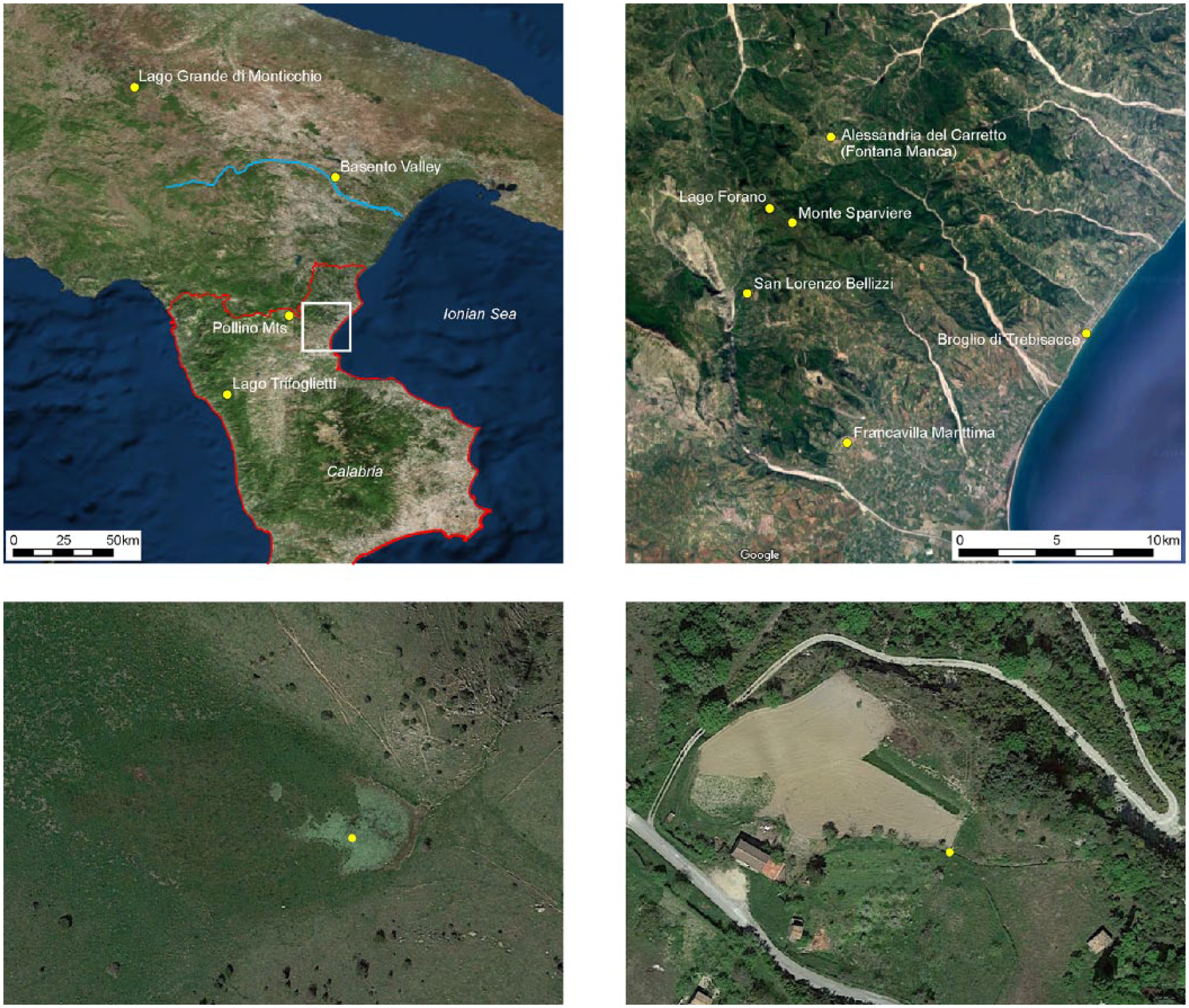
Locations of the area and sites. Left upper: Southern Italy and location of the area of study. Right upper: Area of study and location of Lago Forano and Fontana Manca. Left lower: Lago Forano and coring site (indicated by dot). Right lower: Fontana Manca coring site (dot).
Establishing the Holocene vegetation record for the upland landscape of northern Calabria has specific relevance for the evaluation of potential early human impacts at regional scale. Proxies for such impacts are the increase in the number of settlements and sites recorded in archaeological studies (Attema et al., 2010). While it is known from historical sources that a major Roman transhumance route passed through the area, it has been hypothesized that in preceding periods the uplands were used for mobile pastoralism, based on mounting evidence for the presence of late-Neolithic and early-Bronze Age ceramic find spots in the nearby upper valley of the Raganello River (De Neef, 2016; Ippolito, 2016a).
Holocene pollen records for the higher interior parts of mainland Southern Italy are rare. Lago Trifoglietti at 1048 m a.s.l. (Joannin et al., 2012) is nearest to the Raganello area (see Figure 1a), but it is from the humid Tyrrhenian slope of the Apennines (annual precipitation of 1850 mm), whereas annual precipitation in the Monte Sparviere area is considerably lower. Other cores are at far larger distances, such as the Lago Grande di Monticchio (see Figure 1a, at 650 m a.s.l.; Allen et al., 2002), Lago Alimini Piccolo (at sea level near Otranto, Puglia; Di Rita and Magri, 2009) and Canolo Nuovo (at 945 m a.s.l. Reggio Calabria; Schneider, 1985). Given this situation we decided to re-core the Sparviere locations and to improve the radiocarbon dating by selecting aboveground macro remains of terrestrial plants or charcoal fragments and applying 14C AMS dating. New cores were taken in 2013–2015. At FM, a distinct tephra layer was found that earlier remained unnoticed, but potentially allowed for an independent check of the 14C dates obtained. In this paper, results are presented from the reinterpretation of the original pollen counts within a more reliable time frame, based on existing and new 14C datings, on the identification of the tephra layer, and on the relation between the existing archaeological record and the vegetation history.
Study area
Topography
The LF and FM sites are located in the Monte Sparviere range (max. altitude 1713 m a.s.l.), in the eastern part of the Pollino Massif and facing the Ionian Sea. LF is a former small lake, which still holds some shallow open water during the wet season and is situated near the crest of the range at 1530 m a.s.l. (see Figure 1b and c). Drainage is to the NE through a narrow gap cut into a low ridge with exposed hard sandstone beds. LF covered a considerably larger area than the former lake at FM, which is a very small sediment-filled depression on the slope immediately below the northern outskirts of Alessandria del Carretto (see Figure 1b and d). This former, truly little lake, at 960 m a.s.l. lies in the most northern extension of the Sparviere range at about 5 km from LF.
Climate
Because of its vicinity to Alessandria del Carretto, climatic data for FM are excellent: mean annual temperature is 11oC and annual precipitation is 826 mm (https://it.climate-data.org: 1982-2012). Its ombrothermic diagram is given in Figure 2. For comparison, this figure also shows the diagram for San Lorenzo Bellizzi, to the west of the Sparviere Range, which is rather identical to FM’s ombrothermic diagram. For LF, which lies in a remote area, no data are available. However, precipitation in the Sparviere Range is known to be distinctly lower than in the main Pollino Massif, being shielded by this massif against the relatively wet Tyrrhenian air masses that come in from the west during the rainy season (Brandmayr et al., 2002). Assuming a gradient of 0.6oC per 100 m, which is realistic for such drier range, mean annual temperature at LF will be of the order of 7oC. Annual precipitation is likely in the order of 1000 mm.
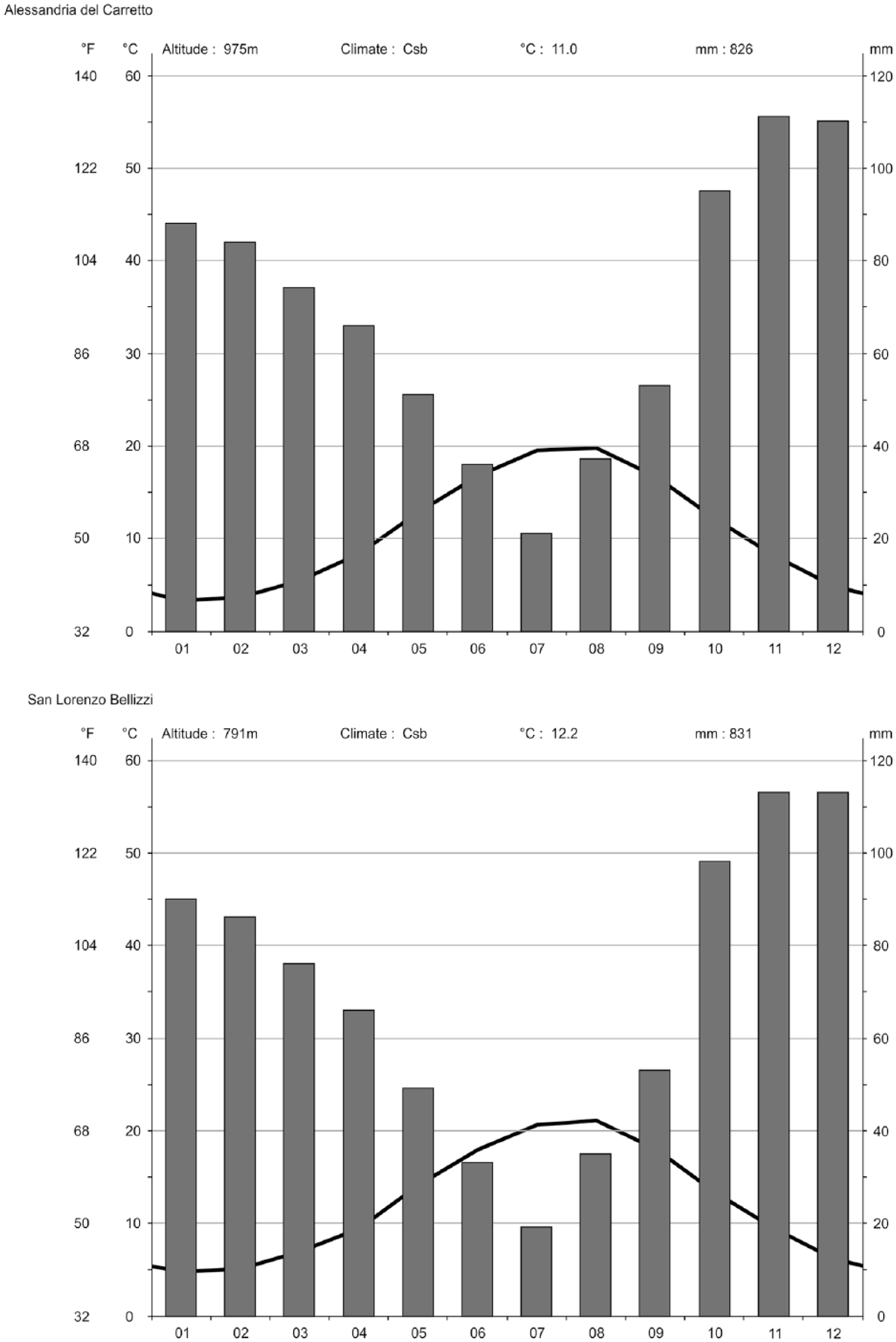
Ombrothermic diagrams for Alessandria del Carretto and San Lorenzo Bellizzi.
Geology
The Monte Sparviere Range largely consists of flyschoid rocks from the Albidona Formation, which in this area is the dominant geological unit (Cesarano et al., 2002) and would be of Eocene age (Baruffini et al., 2000). In broad lines, three lithotypes are distinguished: (1) a lower sandy-clayey member, which is about 850 m thick and consists of an alternation of fine sands and pelites with a grey-olive colour, (2) an intermediate calcaric-clayey-sandy member of similar thickness, composed of marls with intercalations of clays and sands and (3) an upper conglomeratic-sandy member of about 600 m composed of an alternation of sands and granitic conglomerates. In all three members, coarse-grained strata have the characteristics of grauwacke and are fairly dense and hard rocks, the coarser beds standing out because of their higher resistance.
The upper conglomeratic member dominates the crest area, including the LF and its surroundings, and rocks in this area are virtually free of calcium carbonate. The outlet of the LF, a little stream draining the former lake, cuts through parallel bedded and steeply inclined hard sandstone beds. A karstic origin of the shallow depression in which the lake formed can be completely excluded. Given its altitude (1530 m a.s.l.) and N–NE exposure it must be a nivation hollow or related glacial feature from the Pleistocene glacial periods (see e.g. Palmentola et al., 1990).
FM lies in the middle member, with marls as the dominant rock type, containing some calcium carbonate (finely divided, but also partly as fragments of calcite veins in the marls). Although a karstic origin cannot be fully excluded, local slumping or sliding causing a little valley to be blocked, seems to be the most likely explanation for the genesis of the lake.
In the Raganello Basin and adjacent part of southern Italy, thus far distal Holocene tephra have not been reported, but for an ash layer in the Basento Valley near Fosso La Capriola. This tephra was attributed to the Vesuvian AP3 eruption and would date from about 2800 cal. yr BP (Boenzi et al., 2008).
Vegetation
The actual Mediterranean vegetation is to a large extent affected by man. In Calabria, remnants of the original vegetation at higher altitude are preserved in the National Park of the Pollino. The deciduous oaks downy oak, Turkey oak and Hungarian oak (Quercus pubescens Willd., Q. cerris L., Q. frainetto Ten.), the evergreen holm oak (Quercus ilex L.), oriental hornbeam (Carpinus orientalis Miller), sweet chestnut (Castanea sativa Miller), manna ash (Fraxinus ornus L) Montpellier maple (Acer monspessulanum L. and Italian alder (Alnus cordata Loisel.) characterize the vegetation between 800 and 1100 m. In the montane zone (1100–2000 m) deciduous oak species and sweet chestnut occur, while on the Ionian side several maple species (Acer sp.) can be found. Beech (Fagus sylvatica L.) grows in the upper part of this zone. Above 1500 m, silver fir (Abies alba Miller) occurs. Bosnian pine (Pinus heldreichii H. Christ syn. leucodermis) survives in the highest locations (Cocca et al., 2006; Gargaglione, 2001). Veenman (2002) studied the area where FM and LF are situated and analysed the actual vegetation along three transects running from 1100 m a.s.l. towards the coast. Between 1100 and 800 m, she noted a dominance of Turkey oak accompanied by beech, some sessile oak (Quercus petraea (Matt.) Liebl.), elm (Ulmus minor Miller) and, possibly planted, Aleppo pine (Pinus halepensis Miller). Hungarian oak and Italian alder were present as well. At lower ranges the vegetation was very much affected by human activity and grazing.
Methods
Field
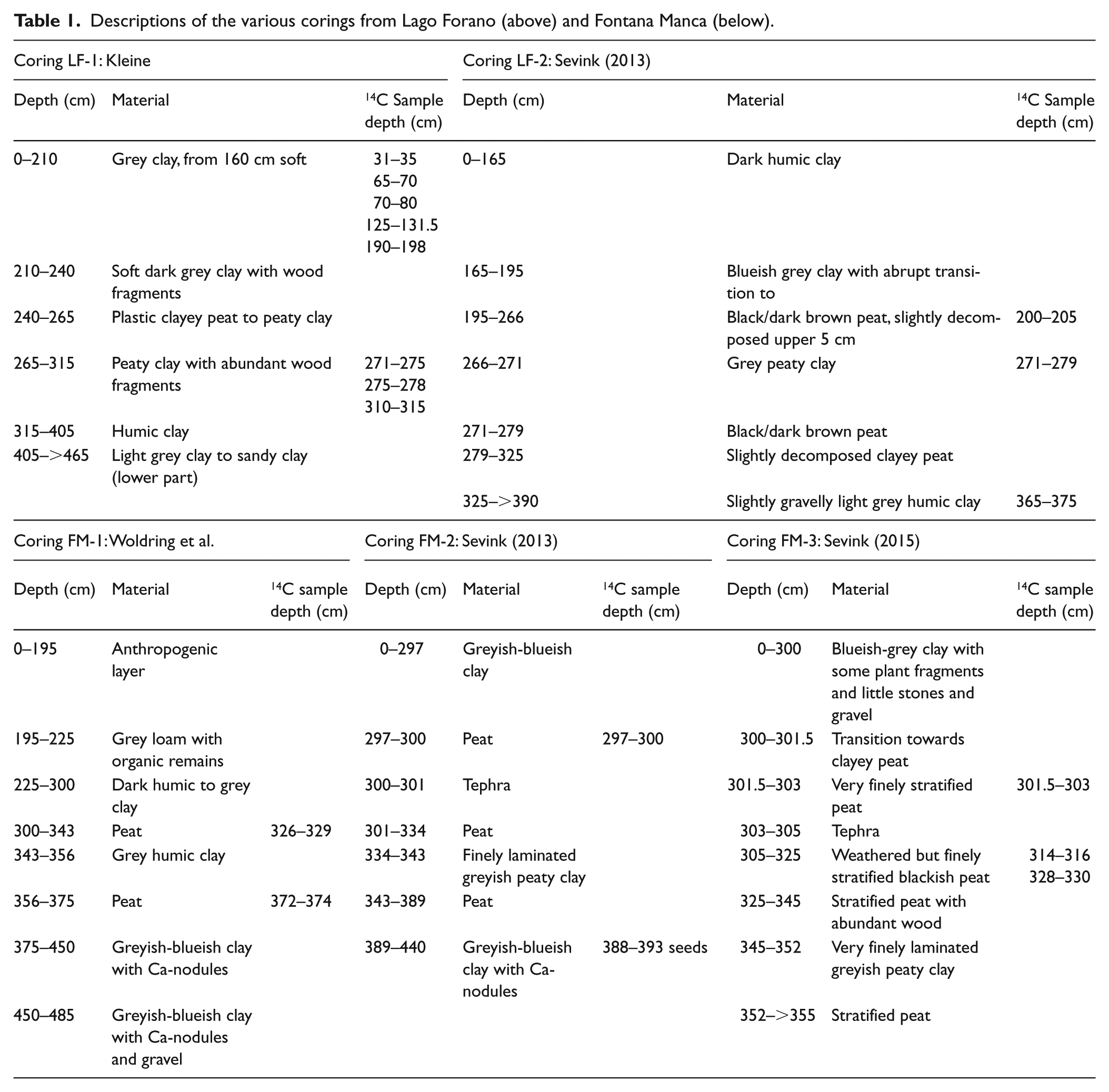
At FM the original coring site (Woldring et al., 2006) was known with an accuracy of <1 m, whereas at LF the original site could not be established with that accuracy, landmarks being absent (Kleine et al., 2005). Here, accuracy will most likely have been <5 m from the original site. Sedimentary sequences were re-cored using a 6 cm gouge auger, with at LF a single core and a duplicate core at FM (taken at about 50 cm from each other). Cores were packed in fitting PVC tubes and transported to the Netherlands for separation of plant macro remains, charcoal and volcanic ash. Cores were described in the field. For descriptions, reference is made in Table 1.
Descriptions of the various corings from Lago Forano (above) and Fontana Manca (below).
Sampling and dating
Cores from both sites were cut into slices of about 2–2.5 cm, depending on the sedimentary sequence and subsequently briefly boiled in a 5% KOH solution after which the series of samples was sieved over a 160 μm sieve to separate the ‘coarser fraction’. Plant macro remains and charcoal were handpicked under the microscope from this coarser fraction. Suitable materials were washed and dried, and subsequently used for 14C AMS-dating. They are listed in Table 2.
Overview of the radiocarbon datings for Lago Forano and Fontana Manca. Sevink (2013) and Sevink (2015) refer to year of sampling, see Introduction and Table 1..
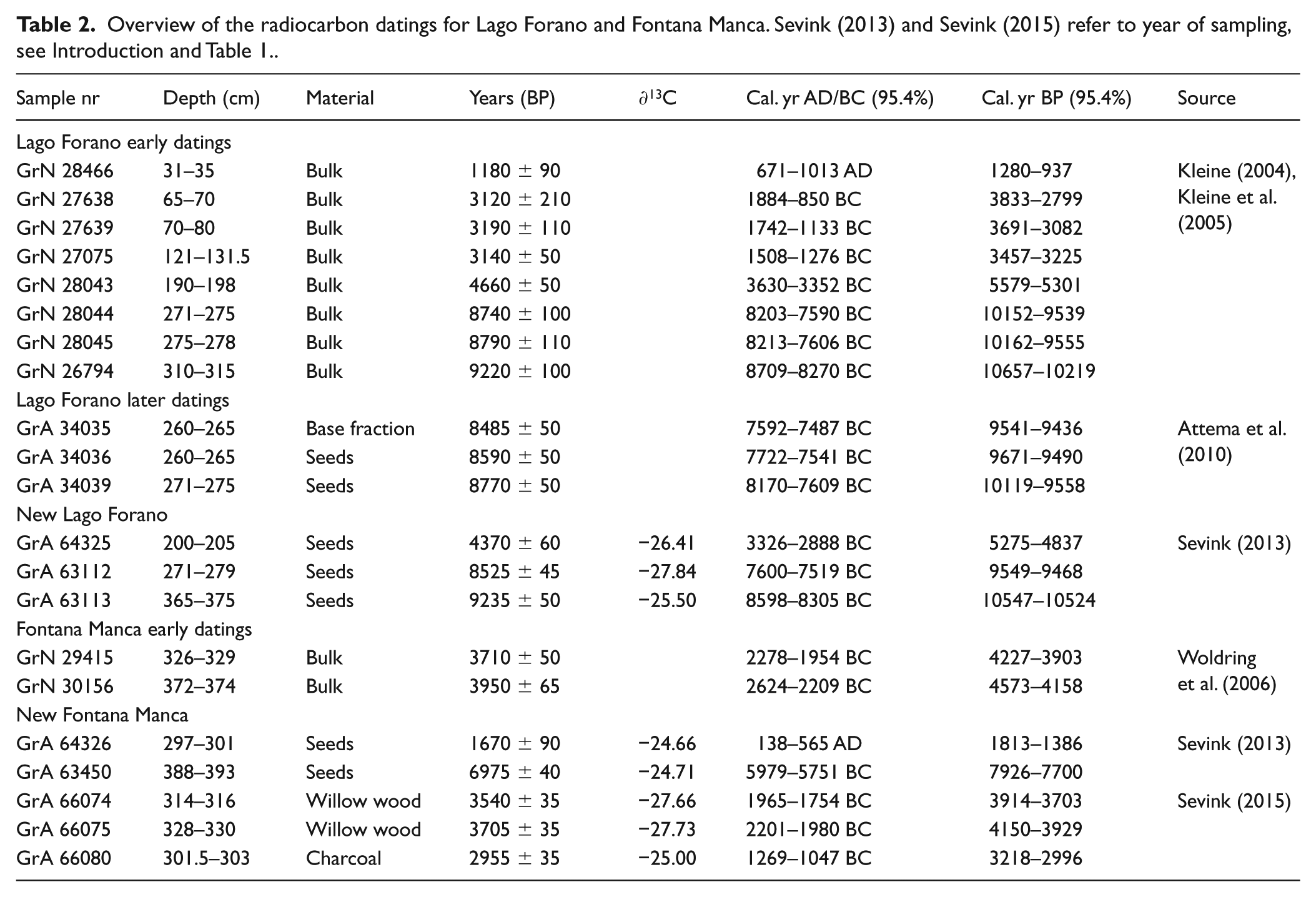
Earlier 14C datings were largely traditional radiocarbon datings on whole samples of the organic matter fraction (see Table 2). Both these earlier data and the more recent AMS radiocarbon dating were carried out at the Centre for Isotope Research of Groningen University (CIO). Samples were pre-treated following the standard procedure (A-B-A, Brock et al., 2010). The dry weight of all AMS samples was more than 10 mg and therefore sufficient for 14C AMS-dating. The results were reported in conventional radiocarbon years, corrected for isotopic fractionation using the stable isotope ratio δ13C, and the conventional half-life (Mook and van der Plicht, 1999). For calibration into calendar age the recommended calibration curve IntCal013 (Reimer et al., 2013) was used, using the Oxcal4.3 software package (Bronk Ramsey, 2017). The 14C dates are reported in years BP and in cal. yr BC or cal. yr AD, with 95.4% significance. Only for the recent 14C datings CIO reported δ13C values. Where relevant, to allow for easy comparison with dates published in non-archaeological studies, we also report in cal. yr BP, with BP set at AD1950.
Tephra
Tephra were separated by sieving, following on pre-treatment with 10% H2O2, after which coarse remaining organic fragments were removed by sieving (>2 mm) and sedimentation, followed by sieving over a 50 μm sieve to remove fines. The fraction >50 μm was dried and used for further analyses.
Strontium (Sr) isotope compositions were determined on handpicked feldspar and pyroxene crystals by Thermal Ionization Mass Spectrometry (TIMS) at the Istituto Nazionale di Geofisica e Vulcanologia, Osservatorio Vesuviano (Naples, Italy), using a ThermoFinnigan Triton TI multicollector mass spectrometer. Mineral samples of 0.2 g were washed several times in pure H2O Milli Q®. After washing and dissolution by high purity acid (HF-HNO3-HCl), Sr was separated by conventional ion-exchange chromatographic techniques. The Sr blank was of the order of 0.15 ng during the period of chemical processing. The measured 87Sr/86Sr isotope ratios were normalized for within-run isotopic fractionation to 86Sr/88Sr = 0.1194. 2σmean, that is, the standard error with N = 180, is better than ± 0.000012 for Sr measurements. During the collection of isotopic data, replicate analyses of NIST SRM 987 (SrCO3) were performed to check for external reproducibility. The external reproducibility (2σ, where σ is the standard deviation of the standard results, according to Goldstein et al., 2003) was 0.710230 ± 0.000019 (2σ, N = 120). Sr isotope ratios of this work have been normalized to the recommended values of NIST SRM 987 (87Sr/86Sr = 0.71025; Thirlwall, 1991).
Palynology
The new cores were used to provide a better time frame for the two existing pollen studies (Kleine, 2004; Woldring et al., 2006). They have not been used for new pollen analysis. Samples have been treated with KOH, bromoform-ethanol gravity separation (s.g. 2.0) and acetolysis. Pollen was identified using Beug (2004), Moore et al. (1991) and a reference collection. Non-pollen palynomorphs were identified according to Van Geel (1978) and Van Geel and Aptroot (2006). For this study, the counts produced by Y. Boekema regarding FM and by E. Kleine regarding LF were entered in the programmes Tilia and TiliaGraph 2.0.41 (Grimm, 2015). New percentage diagrams were drawn based on an upland (dryland) pollen sum. Salix, Poaceae and Cyperaceae were left out because these taxa may have belonged, if only partly, to the wetland vegetation. Alnus was considered upland, because the only Alnus growing in the region is Alnus cordata Loisel, an upland tree. Pollen zones were drawn visually. Cereal pollen (Poaceae >40 mμ) was discerned in LF and Triticum/Hordeum and Avena types in FM, but at least a part of this pollen may derive from wild grasses.
Results and discussion
Profiles and their dating
FM
The various corings at FM all exhibit exactly the same sedimentary sequence. About 3 m of grey clay to clay loam abruptly overlies peat, with a distinct stratigraphic hiatus evidenced by prominent decomposition and compaction of the peat immediately below the boundary (between c. 299 and 302 cm, see Figure 3). Differences in depth of this hiatus are minimal, as expected, considering the limited distance between the several corings. Differences in depth might even be (partly) because of the coring method used, leading to differences in compaction of the cored material (Dachnowsky corer by Woldring and others; gauge corer in 2013 and 2015).
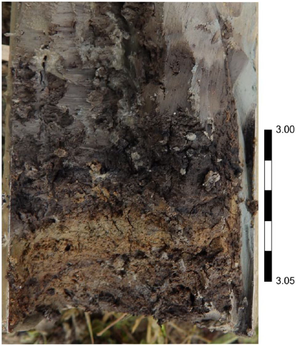
Detail of Fontana Manca core with tephra layer (core 2015). Depth is given in metres. For description, see core 2015, Table 1.
Woldring et al. (2006) did not recognize the thin tephra layer that occurs a few centimetres below the hiatus in the top of the underlying peat (see Figure 3). The peat deposit has a somewhat variable thickness (75 cm: Woldring et al.; 92 cm in 2015), largely consists of finely stratified peat with abundant wood fragments, and holds an intermediate thin stratum (about 10 cm) of rather clayey peat to peaty clay. The peat abruptly overlies greyish blue clay with common gravel-size calcium carbonate nodules and some gravel to a depth of at least about 4.5 m.
14C dates are presented in Table 2. At first sight the dating of the thin peat layer immediately above the tephra layer seems problematic: the samples vary in age from cal. yr AD138–565 (core 2015, seeds, GrA 64326) to 1269–1047 cal. yr BC (core 2016, charcoal, GrA 66080). Given the fact that the upper part of the peat exhibits prominent decomposition, these results can be interpreted as follows: the charcoal represents the remains of peat that disappeared because of strong decomposition under aerobic conditions prior to the phase in which the overlying clay was deposited. The seeds postdate this phase of decomposition, being very well preserved, and most probably are the remains of vegetation present at the onset of the phase in which the clay was deposited. The difference in age between these two samples, therefore, can be seen as a reliable indication for the length of the sedimentary hiatus.
This thin tephra layer is shown in Figure 3, in which the overlying compacted and oxidized layer is also visible as black peaty material, lacking stratification. As for the age of this tephra layer, assuming a constant peat accumulation rate and taking into account some compaction and oxidation, it can be estimated at c. 1700 cal. yr BC (see Figure 4a). A slightly lesser age results for the top of the peat, which exhibits distinct compaction and oxidation (2–3 cm peat above the tephra layer), which would imply that a stratigraphic hiatus exists from between c. 1600 and 1700 cal. yr BC and the Imperial Roman period, after which the upper 3 m of clayey sediment was deposited.
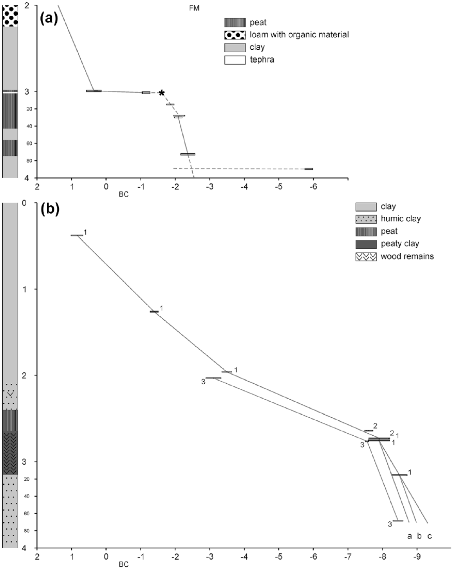
Depth in metres (Y-axis) versus age in kyr BC or AD (X-axis) for (a) Fontana Manca (FM) and (b) Lago Forano (LF). 14C ages are indicated by bars, showing the range at 95.4% probability. ★ = age of tephra based on extrapolated sedimentation rate. Numbers refer to cores as indicated in Table 1; a, b, and c refer to alternative extrapolations, based on sedimentation rates in cores 1 and 3.
As for the origin of the hiatus, it is very likely that peat growth came to a standstill because drainage improved either because of a drier climate or as a result of the natural development of such a small, temporary lake being filled up. Given the archaeological evidence, it is very well possible that the subsequent relatively massive accumulation of clay is because of artificial damming of the depression. In this area, devoid of natural springs, that would have ensured a continuous supply of water for its early habitants. However, testing these hypotheses would require further research into the archaeology and early history of Alessandria del Carretto.
For samples below the tephra layer, the plot of the various ages against depth (Figure 4a) clearly points to a fairly constant peat accumulation rate (c. 10 cm/century) and suggests that the earlier dating of GrN 29415 is reliable. In fact, the match between GrN 29415 and GrA 66075 is excellent (3710 ± 50 BP versus 3705 ± 35 BP). Assuming that the age of sample GrN 29415 is indeed reliable, a significant hiatus exists around 380 cm, since the seeds in the upper centimetres of the underlying clay date from around 5800 cal. yr BC This suggests that the little lake originated shortly before 2500 cal. yr BC (4.5 cal. kyr BP).
LF
Descriptions of the two corings are presented in Table 1 and show that sedimentary boundaries and overall stratigraphy are similar: more or less peaty clay to peat, wedged in between clays. The upper boundary of the organic strata was at 210 (LF-1) and 195 cm (LF-2), respectively. In the recent coring (LF-2), this peat exhibited a slightly decomposed upper section, suggesting the presence of a stratigraphic hiatus. Whereas in coring LF-1 the lower boundary of the peat was at around 315 cm, it was found at 325 cm in coring LF-2. In both corings, sediments are non-calcareous, evidenced by the absence of a reaction with hydrochloric acid.
As described above, it was impossible to establish the exact original position of core LF-1, when taking the LF-2 core in 2012. The slight differences between the cores in depth and thickness of the peat thus can easily be explained because of the slight spatial variability in built up of the sedimentary sequence, in combination with differences in the coring methods used and associated differences in compaction.
In Figure 4b the results from the 14C datings are plotted against the sampling depth. For core LF-1 the problematic reliability of several 14C datings for the upper samples is evident. However, 14C ages obtained for the deeper samples from both cores – traditional 14C method on bulk samples for LF-1 and AMS method on seeds for LF-2 - and sedimentation rates, based on these datings, are nearly identical, strongly suggesting that for the peat sampled ages obtained are reliable for both cores. Based on extrapolation of the sedimentation rates, the peat sections would cover a time span from about 8500 cal. yr BC to about 3000 cal. yr BC, that is, about 5500 years.
Assuming a constant sedimentation rate for the specific types of sediment (peat and clay), the length of the hiatus between the upper clay layer and the peat can be estimated. This hiatus would be of the order of about 500 years at maximum, but whether this is a true hiatus or the sedimentation rate gradually increased is not clear. As for its lower section, using the sedimentation rates found for cores LF-1 and -2, the sediment at 3.6 m depth can be tentatively dated. In Figure 4b, three alternatives are presented (a, b and c): a = rate of core LF-2 from 275 cm down, b = rate of core LF-2 but only for sediment below 315 cm and c = below 315 cm based on rate in core LF-1. Differences between these alternative ages are relatively small, and it is evident that the base dates from c. 9000 cal. yr BC (c. 11000 cal. yr BP), that is, the Preboreal.
Comparison of sedimentation rates
For the peat at LF an accumulation rate of c. 1 cm/80–85 years is calculated, which is considerably lower than at FM, where this rate is of the order of c. 1 cm/10 years. This probably reflects the major differences in origin and geology of the two lakes: LF is in a Pleistocene nivation hollow in relatively resistant grauwackes at truly higher altitude, whereas the lake at FM is in highly calcareous marls at distinctly lower altitude and was relatively short-lived, probably being formed by a mass movement that blocked a local valley or was accompanied by a rotational slip. Furthermore, it is clear that as a whole the cores are marked by significant temporal variation in the sedimentation rate (Figure 4a and b) and, in the case of the FM core, holds a distinct stratigraphic hiatus.
The tephra
The measured 87Sr/86Sr isotope compositions are 0.70793 for feldspar and 0.70767 for pyroxene crystals, values that in Figure 5 are plotted as vertical lines because we could not measure the Nd isotope compositions. The values are distinctly higher than those observed for the Ischia volcanic island and meet the values for the Somma-Vesuvius. As for the latter, distinction can be made between Somma-Vesuvius tephra from the past 39 ka BP and those from the AP eruptions (AP are eruptions that occurred between the Avellino and Pompei Plinian eruptions), characterized by higher Sr isotopic ratios. Products from the Campi Flegrei have not been considered, because they were quiescent during the interval of 2000–1000 cal. yr BC (4000–3000 cal. yr BP). Based on the 14C ages of the samples from the upper peat section of FM, this is the time interval within which the tephra was deposited, thus excluding a Phlegraean origin. More precisely, we estimated the age of the tephra at FM as roughly between 1600 and 1700 cal. yr BC and derived this age from the radiocarbon datings and calculated sedimentation rate (see above). In combination with this presumed age, the isotopic data clearly demonstrate the origin of the tephra: the AP2 eruption, which is the only AP eruption that occurred in the time gap mentioned (e.g. Passariello et al., 2010; Santacroce et al., 2008).
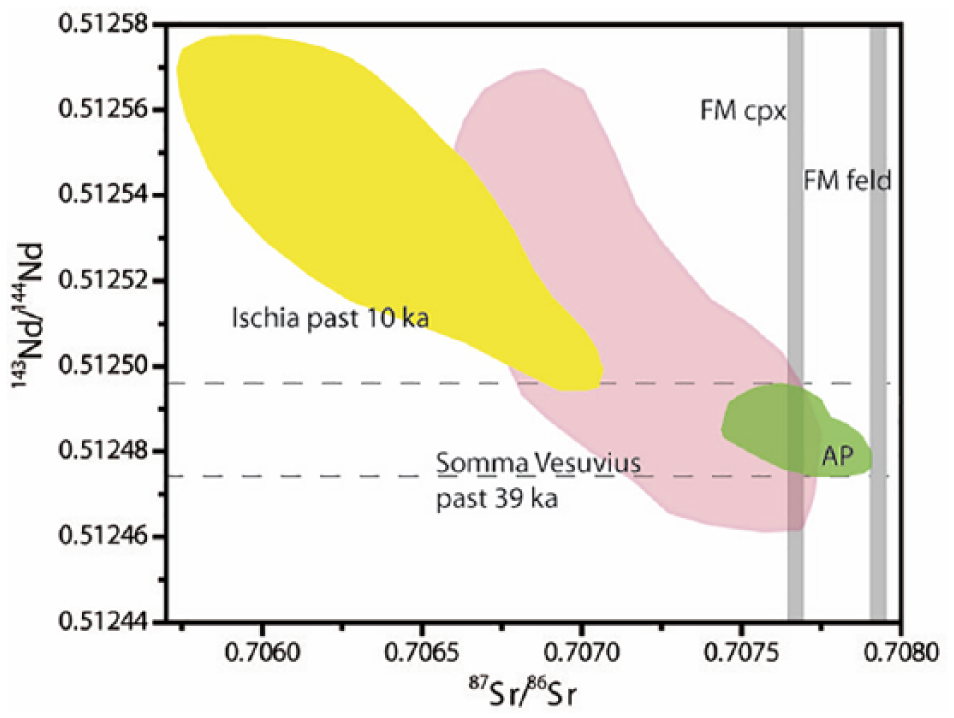
Sr-isotope versus Nd-isotope ratios. Fields are built on literature data for the Ischia volcanics (last 10 ka) and the Somma-Vesuvius volcanic rocks (last 39 ka). For the AP eruptions unpublished data are used (Arienzo). Sr isotope ratios of the minerals from Fontana Manca are represented as vertical lines. Data from the literature are from Cioni et al., 1995; Civetta et al., 1991; D’Antonio et al., 2013; Di Renzo et al., 2007; Iovine et al., 2017 cpx = clino pyroxenes; feld = feldspars (sanidine).
Quite some variation exists in the ages reported in various papers for this AP2 eruption. Vingiani et al. (2017) report an age of 3170 ± 240 cal. yr BP, which was taken from Santacroce (1987). This is considerably younger than the age we obtained. However, Santacroce et al. (2008) reported ‘a best available’ age of the AP2 tephra of 3500 ± 40 cal. yr BP (1550 ± 60 cal. yr BC). Furthermore, Passariello et al. (2010) report considerably earlier ages, published by Rolandi et al. (1998), and an age of 1730–1630 cal. yr BC (3680–3580 cal. yr BP) for a bone above the AP2 layer that they dated. Finally, Jung (2017), using dates for animal bones from below the AP2 layer but assumingly contemporaneous with this event, concluded that it dates from 1689 ± 24 cal. yr BC, which is very similar to the age reported by Passariello et al. (2010). These more recently established ages are very much in line with our presumed age.
In this context, some attention needs to be paid to Boenzi et al. (2008), who described two tephra layers in their study of the relatively nearby Fosso La Capriola (Basento river basin, Basilicata). The oldest was identified as the Avellino tephra and the youngest as AP3 tephra. Although they report that the identification was based on the characteristic chemical and mineralogical composition, and glass particle morphology, data on these are not presented in their paper. The identification is seemingly based on a few 14C datings of charcoal fragments and an assumed 14C age of the Avellino eruption (3700 cal. yr BP), with the tephra layer encountered being younger than 3740 cal. yr BP and older than 3320 cal. yr BP. Recent studies show that the Avellino eruption is distinctly older (e.g. Sevink et al., 2011: 3945 ± 10 cal. yr BP; Zanchetta et al., 2012: 3900–3800 cal. yr BP). We therefore do not exclude that Boenzi et al. (2008) erroneously identified the tephra layer as Avellino tephra, and that in reality this is a layer of AP2 tephra, similar to the tephra layer we found.
Palaeoecology
FM
Figure 6 depicts the FM pollen diagram with the 14C data obtained as described above. Taxa not included are listed in the Supplementary Table 1, available online (FM). The graphs represent three vegetation categories present in the wider region around the former lake: forest, secondary woodland and herbs. Dominant in the forest curve are deciduous oak species among which Quercus cerris-type is the most important. Quercus robur-type, which includes Quercus pubescens and Quercus frainetto, comes second. The next important taxon is Ostrya-type, which includes Carpinus orientalis. This picture is in agreement with the vegetation expected at the altitude of the lake: 960 m a.s.l. Another taxon mentioned for this altitude in the Pollino list presented above is Alnus. Pollen from Acer is present with one single grain and another characteristic tree, Castanea sativa, is only found in the upper part of the diagram. The tree taxa Fagus, Abies and Pinus, belonging to vegetation zones at higher altitude, are present as well, of which Abies is the most important.
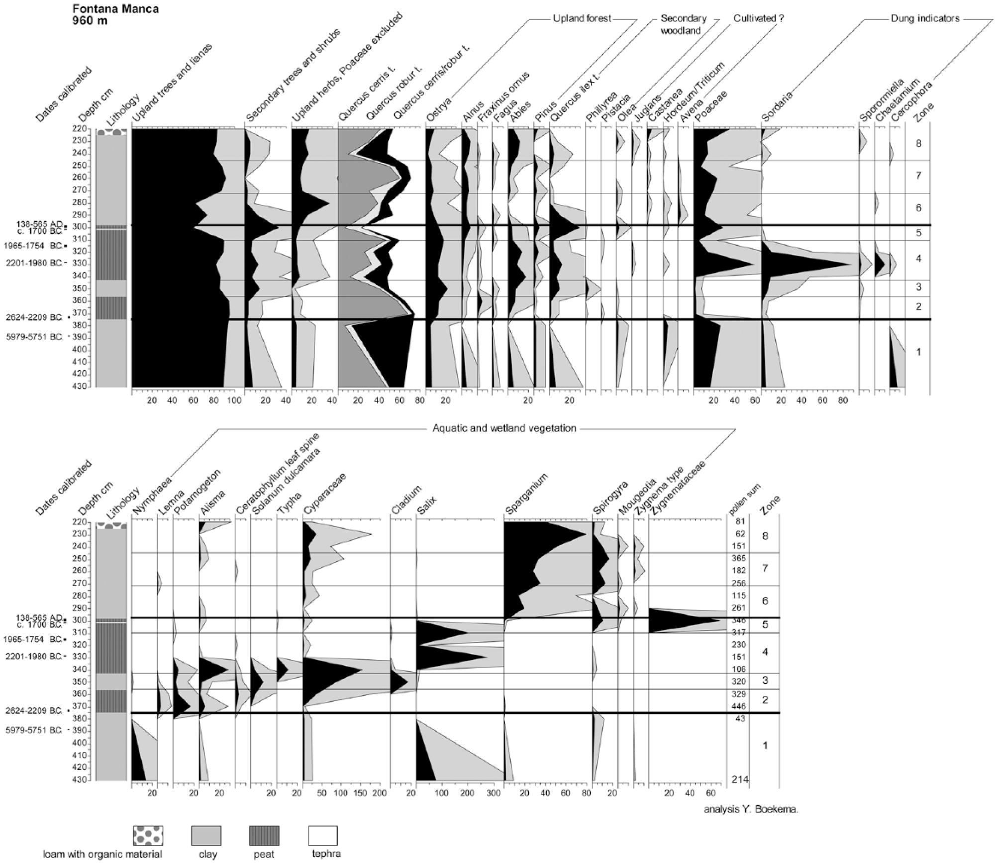
Pollen diagram for Fontana Manca.
Trees and shrubs like Quercus ilex, Phillyrea, Pistacia and Olea are considered as secondary growth, occurring when original forest is degraded. Within this category the Quercus ilex curve is the most important. These taxa may have replaced the original deciduous forest around FM, but the location is rather high for this supposition. This kind of pollen may have flown in with air currents from below when there was sufficient open space to allow this kind of transport. Veenman (2002) found Quercus ilex dominant at 750 m a.s.l.
Zone 1
From the lower clay only two horizons were counted. They indicate that deciduous forest prevailed around FM. The wetland taxa present a picture of a eutrophic lake with Nymphaea, surrounded by Salix. A date of cal. yr BC 5979–5751 was obtained for the upper part. A hiatus is supposed to separate zone 2 from zone 1.
Zone 2
The deciduous forest persists, but its composition has changed. The curve of Quercus cerris pollen is falling and the Ostrya percentages rise. Fraxinus ornus values have their optimum in this zone. Fagus and Abies curves rise as well. It looks as if the area around the lake is affected and becomes more open, giving opportunities to other species and catching more pollen from higher vegetation zones, for instance, Abies.
Salix disappears from the lake edge and the lake becomes shallower. Plants like Potamogeton and Alisma replace Nymphaea and peat formation sets in. The beginning of the change is dated 2624–2209 cal. yr BC.
Zone 3
During zone 3 the sediment becomes more clayey. The degradation of the forest continues. Secondary growth pollen percentages rise and the lake turns into a marsh with a sedge (Cyperaceae) vegetation including Cladium. Remarkable is the rise in Sordaria and Sporormiella spores, both indicators of the presence of dung.
Zone 4
This zone is remarkable for a maximum value in Poaceae pollen and a strong return of Salix. The deposition of clay has stopped and peat formation resumes. The rises in Poaceae and Salix may not represent anything dramatic, but may represent just another stage in the development of the vegetation in the lake and on its edge. Indications of open water are near absent. Dung indicators are very well represented. In addition to Sordaria and Sporormiella, Chaetamium and Cercophora were detected. The maximum of dung indicators is dated 2201–1980 cal. yr BC. The top of the zone, showing the transition to zone 5, is dated 1965–1754 cal. yr BC.
Zone 5
Zone 5 stands out for a strong decline in the values of upland tree species. Secondary vegetation and after that upland herb percentages show a rise. Herb pollen rises in percentages. It may very well be that the environment of FM is now seriously affected by man. However, such an interpretation should be looked at with caution. During the formation of the peat the AP2 ash was deposited. The resolution of the diagram, with only two spectra within this zone, is not sufficiently high to assess the influence of this event, dated at c. 1700 cal. yr BC, but it may have had some effect on the vegetation. The interpretation is not made easier because zone 5 ends with a serious hiatus. Peat formation in the depression is replaced by clay deposition. During zone 5 the depression was a marshy area with shallow pools as indicated by the presence of algae such as Spirogyra, Mougeotia, Zygnema-type and other Zygnemataceae.
Zone 6
Zone 6 is characterized by the lowest percentages of upland tree pollen and the highest percentages of upland herbs. This development is not because of deciduous Quercus, but because of the almost complete disappearance of Abies. A reason may be that pollen from this tree could not reach the depression because it got trapped in higher vegetation around the marsh, but this is unlikely. The belt of Salix has disappeared and upland herb pollen, which would have suffered from the same cause, rises in percentages. Zone 6 is also the zone where Castanea appears. Unfortunately, no date could be provided for the zone, but a hint is given by the 14C date of seeds embedded in the thin peat layer on top of the AP2 ash, namely cal. yr AD 138–565. If the seeds that provided the date got worked into the uppermost part of the peat during the first deposition of clay, this implies deposition from Roman times, or later, onwards. The seeds may have been trapped in the peat during the period of absence of deposition, but this is less likely. They were in good condition and such seeds should be badly weathered if they had lain on the surface of a peat drying out. The depression became a marsh dominated by Sparganium.
Zones 7 and 8
Zone 7 shows a partial return of trees, especially of the oak Quercus cerris and Abies. The depression remains a wetland. The marsh persists during zone 8, but the oak pollen percentages again decline strongly and upland herb vegetation percentages rise. Dung indicators are present. Abies percentages rise, but this may be a relative rise because of a better chance of its pollen to get trapped in the sediment owing to the absence of higher vegetation around the marsh. Also, its pollen may have been washed in together with sediment that came down from eroding slopes higher up in the mountain, a possibility that must also be kept in mind regarding zones 6 and 7.
LF
LF is situated at a much higher altitude than FM, at 1530 m a.s.l. The pollen diagram is shown in Figure 7, and the taxa not presented there are listed in Supplementary Table 2, available online. The original author reports that she had difficulties with the attribution of Quercus pollen to its several types. Therefore, the values of Quercus robur-type (here Quercus pubescens and Quercus frainetto) and Quercus cerris-type may not be entirely representative of the trees they should cover. Nevertheless, deciduous oak dominates the record and at first sight, this is surprising in regard to the altitude of the site. In general, more Fagus would have been expected. However, the relative dryness of the region will have prevented the development of beech stands as the tree thrives best at around 1200 mm annual precipitation (Huntley et al., 1989).
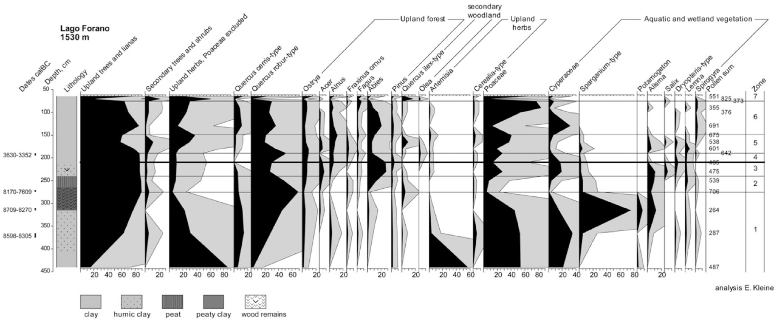
Pollen diagram for Lago Forano.
Zone 1
The lowest zone is characterized by the transformation of the landscape from a steppe with Artemisia to a forest with deciduous trees, mainly Quercus. At the end of the zone, a belt of wetland plants such as Sparganium and Alisma surrounds the lake. Around 8709–8270 cal. yr BC the clayey sediment in the lake develops into peaty clay with wood remains.
Zone 2
In zone 2 the tree cover of the region reaches its maximum, but the relative share of Quercus falls, perhaps because of the appearance of Abies.
Zone 3
The zone is characterized by a relatively low Quercus and high Abies pollen percentages. The lake obtains a belt of Salix and, presumably, marsh ferns (Dryopteris type). Sedges (Cyperaceae) dominate the local vegetation in the lake. The sediment loses its peaty character. The boundary between zones 3 and 4 at 210 cm below surface is rather abrupt and as is suggested in 4.1.2, the presence of a hiatus of unknown length is likely.
Zone 4
From this zone upwards the deposition of clay dominates the record. Quercus pollen percentages rise again and those of Abies fall. A part of the marsh vegetation (Salix and Alisma) vanishes. The end is dated 3630–3352 cal. yr BC.
Zone 5
The values for Abies are low while the percentages of deciduous Quercus undergo a decline as well. The curve of herb pollen percentages rises. A temporary rise in Fraxinus ornus, Quercus ilex and Olea pollen percentages may indicate a phase of secondary forest during the events that led to open vegetation, but, as mentioned before, this pollen may not have been produced by the vegetation around the lake, but may have arrived from lower altitudes.
Zone 6
This zone reveals a return of forest, at least at its start, but this does not last. Herb percentages rise again and also a part of the Poaceae may originate from the dry terrain outside the lake. Algae, for instance Spirogyra, show that the lake still holds water.
Zone 7
The two uppermost spectra are very different from the rest. They originate from a depth of 65 and 70 cm below the present surface and may represent recent or sub-recent vegetation.
Evaluation of the pollen records
The lowest spectrum at LF indicates that deposition started in the late-Pleistocene with vegetation dominated by herbs, while the other spectra are to be ascribed to the Holocene. Forest composed of deciduous trees, and in a later stage silver fir (Abies), superseded the steppe. The conspicuous increase in relative abundance of Abies from 8000 to 7600 cal. yr BC onwards is not apparent in the Lago Trifoglietti diagram, obtained from a lake at 50 km distance as the crow flies, but is seen in the Lago Grande di Monticchio (Allen et al., 2002; Joannin et al., 2012). A series of fluctuations in the pollen record of the upland vegetation followed. After c. 3600–3300 cal. yr BC the surroundings of the lake lost a part of its tree cover (zone 5). Later, forest recovered, but a second phase of loss of trees followed. The question is whether these serious fluctuations are to be ascribed to climate, alteration of the soil characteristics or anthropogenic impact.
Since forest did return after the first tree decline in zone 5, severe degradation of the soil is very unlikely. An obvious cause would seemingly be anthropogenic impacts, but before reaching this conclusion, results from recent studies on the 4.2 cal. kyr BP climatic event should be considered, which was a relative dry phase (Joannin et al., 2012). This event has been observed at many Italian sites south of 43oN, as described by Di Rita and Magri (2009) and by Zanchetta et al. (2016). It is also noted for Lago Trifoglietti (Joannin et al., 2012). The suggested cause is a natural phenomenon related to a general progression of a North African high-pressure cell affecting southern Italy. Very recently Di Rita et al. (2018) concluded that the event is the result of a complex interplay of different climate modes, additionally providing further evidence for its occurrence and age. This event may very well be the true cause for the first forest decline at LF, which starts at around 180 cm depth and is optimal around a depth that indeed corresponds with an age of c. 4.2 cal. kyr BP. The second decline of the forest, starting at c. 130 cm, can be dated at c. 1500 cal. yr BC, using the depth–age relationship for this part of the core (see Figure 4a).
The FM diagram does not represent the long stretch of time that is provided by LF. It covers its upper part, but with a higher resolution. An alteration and subsequent degradation of the original forest started in a period after 2624–2209 cal. yr BC. This phase is most likely contemporaneous with the first forest decline observed in LF and better dated. The presence of several dung indicators shows that concentrations of animals must have been present near the depression. The optimum of this forest decline was around 2201–1980 cal. yr BC. After 1965–1754 cal. yr BC the tree cover recuperated to some extent. Assuming that the forest decline is indeed because of a climatic event (a dry phase), it is possible that scarce remnants of pools attracted wild fauna. A concentration of wild animals may also have affected the local vegetation by intensive browsing and grazing, thereby reducing the tree growth still more. Alternatively, if the decline is attributable to anthropogenic exploitation of the environment, the dung indicators may point to the presence of herds of domestic animals. A third possibility is that the natural opening up of the forest made the area attractive to pastoralists and that the activity of their flocks added to the impact.
A second, still heavier, impact followed. During this phase the AP2 ash was deposited. According to the Trifoglietti data the climate was not extremely dry at that time. Peat growth continued after this event, and the impact may have been anthropogenic. However, the following hiatus hampers further interpretation. The occurrence of a hiatus is mainly apparent in the wetland part of the diagram. The arrival of a load of clay changed the local vegetation. As mentioned above, its start may be dated at cal. yr AD 138–565. In the upland pollen the only hint at a hiatus is provided by the appearance of Castanea (sweet chestnut) and this tree may support the dating.
Mercuri et al. (2013) discussed the history of Castanea as part of the OJC group (Olea, Juglans, Castanea). A definite rise in Olea (olive), Juglans (walnut) and Castanea pollen percentages indicates human activity; many pollen records show that Juglans and Castanea spread with the Roman culture (Mercuri et al. 2013). In the FM diagram Olea and Juglans are present before the clay deposition, but not with continuous curves. Castanea displays the rise which may indicate cultivation and this suggests a Roman date for the start of the sedimentation. However, it is not a definite proof. In the Trifoglietti diagram Castanea is present during the entire Holocene and rises only in the Middle Ages. Nevertheless, the combination of the 14C date and the Castanea curve makes a Roman date for the arrival of clay likely.
Settlement intensity and human impact
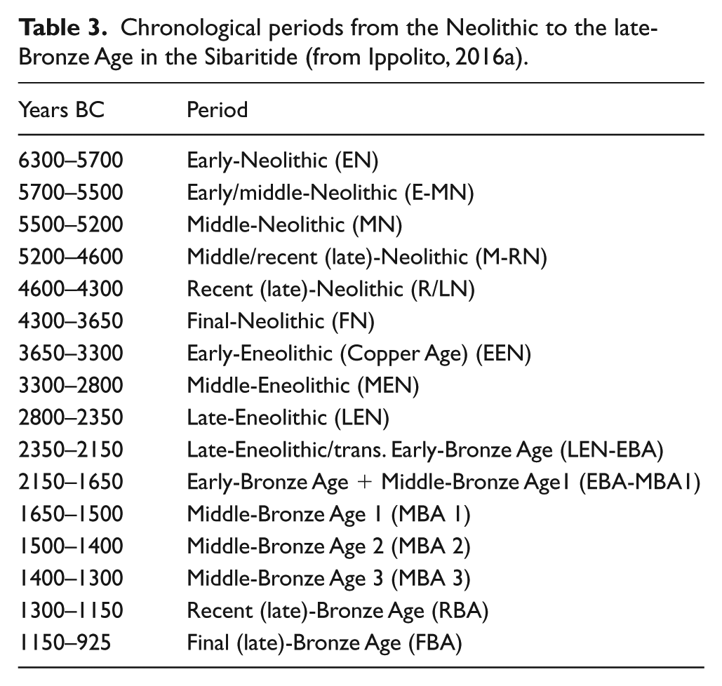
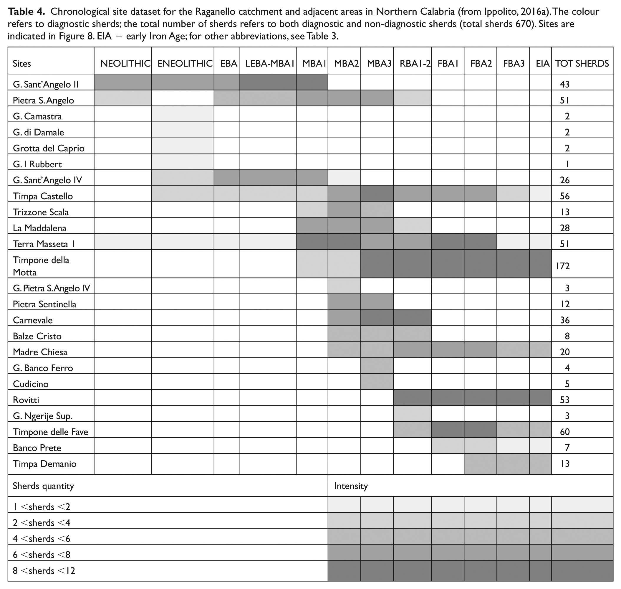
The upland pollen cores of LF and FM are located at a short distance from the middle valley of the Raganello (Figure 1b). For this area, we have a substantial dataset of late pre- and protohistoric archaeological find spots that were inventoried in the course of the Raganello Archaeological Project and well dated on the basis of diagnostic pottery sherds by Ippolito (2016a). The cultural chronology of the Bronze Age in Calabria is given in Table 3. The chronological site dataset (Table 4 and Figure 8) makes it possible to broadly compare the vegetation impacts observed in the upland pollen cores of LF and FM with the intensity of settlement development and the associated land use in the middle valley of the Raganello.
Chronological periods from the Neolithic to the late-Bronze Age in the Sibaritide (from Ippolito, 2016a).
Chronological site dataset for the Raganello catchment and adjacent areas in Northern Calabria (from Ippolito, 2016a). The colour refers to diagnostic sherds; the total number of sherds refers to both diagnostic and non-diagnostic sherds (total sherds 670). Sites are indicated in Figure 8. EIA = early Iron Age; for other abbreviations, see Table 3.
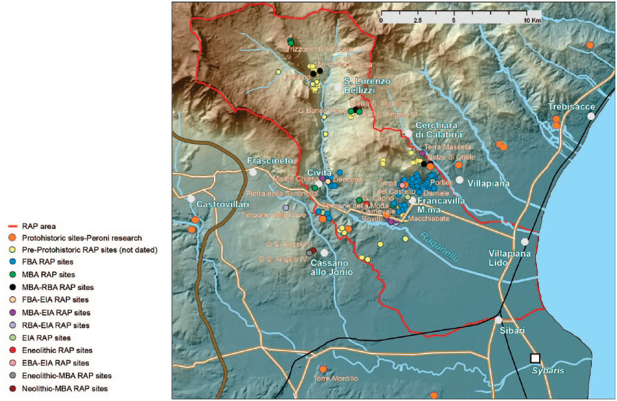
Settlement distribution in the Raganello catchment. For location of Fontana Manca and Lago Forano, see Figure 1b.
We focus on three impacts; the early one falling in cultural terms in the Neolithic/early-Bronze Age, the second starting in the middle-Bronze Age 2 (but which cannot be traced further in time because of a hiatus in the pollen data), and a third one dated broadly to the Roman period.
From the Neolithic to the end of the early-Bronze Age, most evidence comes from caves and in most, if not all, cases we deal with funerary contexts (Ippolito, 2016b). Material evidence relating to open-air sites does occur, but is very sparsely attested. Considering the millennia long period we deal with, we see the sparse settlement evidence as an indication of low, though difficult to quantify, population numbers. Thus, the impact on the upland vegetation near LF and FMc, dated to the late-Neolithic/early-Bronze Age period, is unlikely to have been caused by serious human interference in the form of tree felling and subsequent pastoralism, necessitated by the need for resources of the communities living in the middle Raganello valley.
The number of settlement attestations increases from the middle-Bronze Age I onwards, but the archaeological evidence suggests that it is especially during the middle-Bronze Age 2 and 3 that settlement starts to spread over the valley and village communities start to fill in landscape niches suitable for a combination of subsistence farming and mobile pastoralism. Based on these archaeological data, this intensification of settlement and land use occurred in a relatively short period of ca. 200 years lasting to the final-Bronze Age–early-Iron Age transition around 1000 cal. yr BC, although a decline in settlement evidence already set in before the end of the Bronze Age (Ippolito, 2016a).
The increased settlement evidence for the middle-Bronze Age 2 and 3 periods rather postdates the second impact noted in the pollen record of FM, since that impact becomes already visible at c. 1700 cal. yr BC, suggesting an even earlier onset of human impact on the landscape because of settlement development at moderate altitudes. At LF the impact seems to be somewhat later, around 1500 cal. yr BC, more in line with the current archaeological evidence (see Table 4). Anyway, judging from this evidence, it is plausible that from that time on the middle-Bronze Age village communities in the middle Raganello valley exerted significant pressure on the vegetation in the nearby uplands.
Noteworthy in the archaeological record of the middle valley of the Raganello basin is the gradual decrease of settlement evidence during the last stages of the Bronze Age and the virtual absence of sites in the Iron Age (Ippolito, 2016a). This lack of settlement evidence in the uplands cannot be equated with lack of exploitation of the uplands: contemporaneous with the abandonment of the uplands we see a concentration of population in larger, so-called proto-urban settlements (Peroni and Trucco, 1994) in the final-Bronze age and early-Iron Age, located in the foothills overlooking the coast. Their rise is accompanied by rural infill surrounding these settlements (De Neef, 2016). Given the short distances from these sites to the uplands of LF and FM, it is likely that exploitation of the uplands continued, especially for more wide-ranging mobile pastoralism.
A recent study of the archaeozoological evidence from the proto-urban sites of Timpone della Motta at Francavilla Marittima and Broglio di Trebisacce indicates an important role for sheep/goat and cattle in the subsistence strategies of these two settlements from the middle-Bronze Age into the early-Iron Age (Elevelt, 2012). Geographically, increased exploitation by the community of Broglio di Trebisacce of the uplands around LF and FM for pastoralism is likely (Matteucci, 1984, for the importance of summer pastures and a hypothesis on drove roads between Broglio di Trebisacce and the uplands). Unfortunately, because of the hiatus in the pollen data, we are unable to link the growth of the proto-urban centres and their need for upland resources during the later-Bronze Age and Iron Age with environmental impacts in the uplands during this period.
The abandonment of the upland for settlement purposes lasted till the Hellenistic period when archaeological evidence for the existence of small farmsteads appears in the middle valley. In the vicinity of the FM core there is evidence for Roman settlement, most likely related to the historically known and long used transhumance route of the so-called ‘via della Reggia’ linking the coastal plain with the uplands. Diagnostic potsherds from Roman sites date to the period between the 1st century BC and the 1st century AD. Transhumance between the coastal plains of the Adriatic and the uplands is thus a likely cause for the impact on the vegetation that we see in the pollen data for the Roman period.
Conclusion
The sedimentary sequences in the former lakes at LF and FM hold important archives that demonstrate several phases of forest decline. The first of these started after 2500 cal. yr BC and can be linked to the well-known 4.2 cal. kyr BP climatic event, which has been widely observed in the central Mediterranean basin. In the previous studies (Attema et al., 2010; Woldring et al., 2006), this impact was ascribed to Bronze Age pastoralism, but the archaeological data indicate sparse settlement and this makes an important anthropogenic impact less likely.
A major early middle-Bronze Age anthropogenic impact is revealed by the second, heavier phase of forest decline present in both the FM and the LF diagrams, and its start dates from around 1700 cal. yr BC. This dating is well in line with the known archaeological record for the area and stresses the impact of this phase, first on the vegetation at medium altitude (FM), a few centuries later followed by the upland vegetation (LF).
Interestingly, during the early part of this second phase a thin layer of tephra from the AP2 eruption of the Vesuvius was deposited, which according to the most recent literature dates from 1689 ± 24 cal. BC (Jung, 2017). This is the first recorded occurrence of this tephra in Calabria and represents a very useful tephrochronological marker, though some debate still exists on its age (see also Santacroce et al., 2008).
In the Roman period clay deposition smothered the FM depression, probably as the result of a severe human impact. A similar massive deposition of clay is also observed at LF, pointing to a general, massive disturbance of the upland vegetation and landscape, and concurrent soil degradation.
As described in the ‘Introduction’, Holocene pollen records from the southernmost parts of mainland Italy are rare. The important Lago Trifoglietti diagram was obtained from an area described by its authors as falling ‘within the “lower mesotemperate bioclimate belt” of a temperate region and the ombrotype is upper hyperhumid’ (Joannin et al., 2012: 1975). Both records reported here reflect the vegetation history of a drier region. One, FM, was obtained from an elevation comparable with Lago Trifoglietti, but the other one, LF, came from a much higher elevation. One of the results of the analysis of these depressions is that their palaeorecords exhibit the 4.2 cal. kyr BP event and, in the case of LF, does so even more prominent than Lago Trifoglietti. It is concluded that the drier climatic conditions characteristic for this event had a distinct impact on the already relatively dry uplands of Northern Calabria
Supplemental Material
Supplementary_Table_I – Supplemental material for Holocene vegetation record of upland northern Calabria, Italy: Environmental change and human impact
Supplemental material, Supplementary_Table_I for Holocene vegetation record of upland northern Calabria, Italy: Environmental change and human impact by Jan Sevink, Corrie C Bakels, Peter Attema, Mauro di Vito and Ilenia Arienzo in The Holocene
Supplemental Material
Supplementary_Table_II – Supplemental material for Holocene vegetation record of upland northern Calabria, Italy: Environmental change and human impact
Supplemental material, Supplementary_Table_II for Holocene vegetation record of upland northern Calabria, Italy: Environmental change and human impact by Jan Sevink, Corrie C Bakels, Peter Attema, Mauro di Vito and Ilenia Arienzo in The Holocene
Footnotes
Acknowledgements
Sincere thanks are due to the authors of earlier pollen studies, E. Kleine, H. Woldring and Y. Boekema. Their pollen data were indispensable for our study and their help in the retrieval of these data is sincerely acknowledged, as is the aid by R. Cappers in this retrieval. M. van Leusen and A. Larocca, involved in the successive GIA projects in Calabria, helped us with finding the earlier coring locations. JS performed these new corings with the able help of M. den Haan, J. Wamsteker and N. Noorda. Radiocarbon data were produced by the CIO radiocarbon unit (Groningen) under the supervision of J. van der Plicht, who aided us with the evaluation of the datings that were earlier performed by this lab. B. van Geel and R. Cappers supported the identification and selection of datable plant macro remains from the new cores, while E.E. van Hees identified wood fragments, which were used for 14C dating. F. Ippolito provided the tables and figure holding the detailed information on the settlement chronology and distribution. E. Bolhuis, S. Tiebackx and J. Porck are thanked for producing the illustrations. Finally, we thank two anonymous reviewers for their comments, which helped to improve our manuscript.
Funding
The author(s) received no financial support for the research, authorship and/or publication of this article.
Supplemental material
Supplemental material for this article is available online.
References
Supplementary Material
Please find the following supplemental material available below.
For Open Access articles published under a Creative Commons License, all supplemental material carries the same license as the article it is associated with.
For non-Open Access articles published, all supplemental material carries a non-exclusive license, and permission requests for re-use of supplemental material or any part of supplemental material shall be sent directly to the copyright owner as specified in the copyright notice associated with the article.