
Abstract
The spatial variability of Holocene relative sea level (RSL) in the South China Sea is unknown, with data restricted to Thailand, the Malay Peninsula, and a few other isolated sites. In this study, we present new continuous RSL records for Borneo using surveyed and U–Th dated coral microatolls from four sites in western Sarawak. The record spans 450 years of RSL from 7450 to 7000 yr BP. Our data suggest that RSL was higher than present and rapid RSL rise had ceased by 7450 yr BP. We compare these RSL reconstructions with a regional model of glacial-isostatic adjustment (GIA). The RSL reconstructions from three sites off the coast of Sarawak show a spatial gradient opposite to that predicted by the GIA model. This disagreement can best be explained by tectonic deformation since 7000 yr BP, which was previously unrecognized. We propose vertical land motion of 0.7–1.45 m due to slip on the Serabang fault, which runs between our four sites. This slip may have occurred in response to the loading of the Sunda Shelf by rising sea level.
Keywords
Introduction
Reconstructions of Holocene relative sea level (RSL) provide context for projections of the magnitude and rate of future sea-level rise (Dutton et al., 2015). Changes in RSL, which is defined as the height of the ocean surface relative to the land surface or ocean floor (Khan et al., 2015), are not globally uniform (Milne et al., 2009). RSL is influenced by a combination of factors that act over a variety of spatial and temporal scales (Shennan and Horton, 2002). At regional scales, glacio- and hydro-isostasy, ocean dynamics, and tectonics are the main processes driving the RSL signal over Holocene timescales. At local scales, tidal regime changes and sediment consolidation can influence RSL records. Reconstructions of RSL far from major glaciated locations are referred to as far field (Pluet and Pirazzoli, 1991). In these locations, eustatic contributions to RSL change generally exceeded glacio-isostatic contributions during the early and mid-Holocene (e.g. Lambeck et al., 2014). The RSL reconstructions of many tectonically stable far-field locations are characterized by a mid-Holocene RSL highstand, at the time meltwater production decreased (e.g. Angulo and Lessa, 1997; Baker and Haworth, 2000; Grossman et al., 1998; Hanebuth et al., 2011; Lambeck et al., 2014). The timing and magnitude of the highstand can be used to provide information about the nature of the end of melting of the global ice sheets. Following this highstand, the fall in RSL to present is due to a combination of hydro-isostatic loading (continental levering) and a global fall in the ocean surface due to equatorial ocean siphoning, that is, a flow of water away from far-field regions and into collapsing forebulges near formerly glaciated regions (Milne and Mitrovica, 2008; Mitrovica and Peltier, 1991).
Sundaland is located in Southeast Asia, comprising the Malay Peninsula and parts of Thailand, Borneo, Sumatra, and Java. It is considered to be tectonically stable, based in part on GPS studies (Simons et al., 2007). Over this region (Figure 1), there is considerable variability in the timing and amplitude of the Holocene highstand (Figure 2), with estimates of the timing between 7000 and 4000 yr BP and amplitudes of 1–5 m above present (Horton et al., 2005 (and references therein); Bird et al., 2007, 2010; Parham et al., 2014). The variability of the mid-Holocene highstand is supported by a glacial-isostatic adjustment (GIA) model of Bradley et al. (2016) which showed variability in RSL of more than 4 m at different locations on Sundaland at 7000 yr BP. The model is calibrated to RSL reconstructions from China, Thailand, and the Malay Peninsula and it is unknown whether it is applicable elsewhere in the South China Sea.
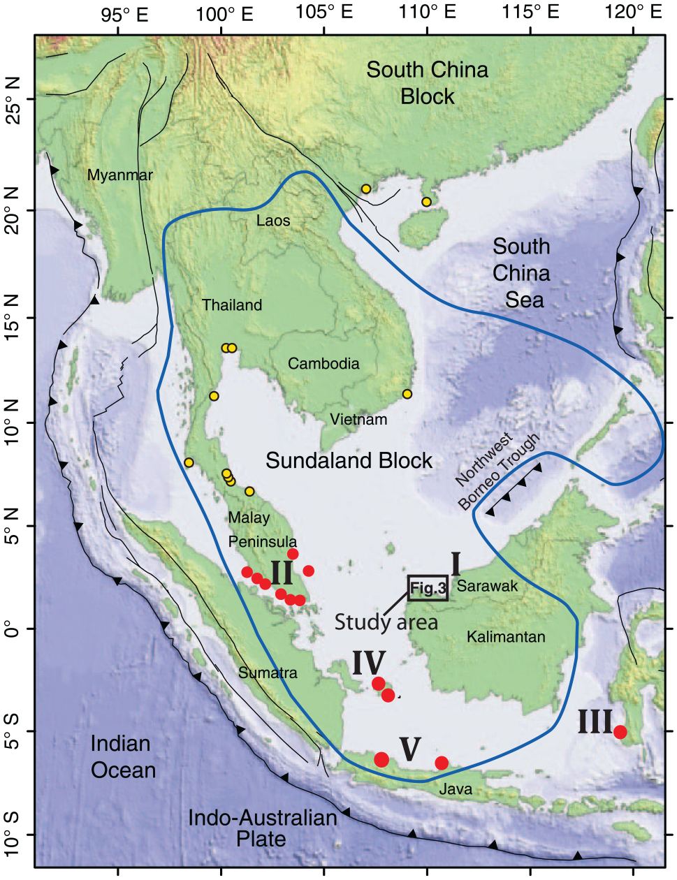
Map of Southeast Asia with the approximate borders of the tectonically stable Sundaland outlined after Simons et al. (2007). Roman numerals show study sites, arranged by regional grouping. I – Sarawak sites: this study; II – Malay Peninsula and Singapore studies: Geyh et al. (1979), Tjia (1996), Hesp et al. (1998), Kamaludin (2002), Horton et al. (2005), Bird et al. (2010, 2007); III – Strait of Makassar: Mann et al. (2016); IV – Belitung: Meltzner et al. (2017); V – northern Java: Azmy et al. (2008). Solid circles show locations of sites discussed while circles with dark outline represent other RSL studies on or near Sundaland not discussed in this paper (Boyd and Lamb, 2004; Chaimanee et al., 1985; Scoffin and Le Tissier, 1998; Sinsakul, 1990; Somboon, 1988; Somboon and Thiramongkol, 1992; Stattegger et al., 2013; Thiramongkol, 1984; Tiyapunte and Theerarungsikul, 1988; Yu et al., 2009). Details of study area are shown in Figure 3. Map modified from Meltzner et al. (2017).
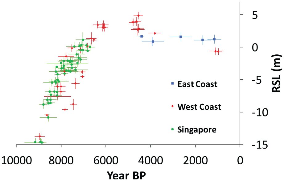
Relative sea level (RSL) history on the Malay Peninsula is characterized by a spatial difference in the timing and height of the mid-Holocene RSL highstand. Note higher RSL on the west coast of the Malay Peninsula. Original data from Geyh et al. (1979), Tjia and Fuji (1992), Bird et al. (2010, 2007) and Kamaludin (2002). Indicative RSL meaning of some data and errors plotted as reinterpreted by Horton et al. (2005).
Here, we produce a continuous 450-year proxy RSL record (7450–7000 yr BP) using coral microatolls from three sites in western Sarawak, Borneo (Figure 1). This record is supplemented with additional proxy RSL data from younger microatolls at a fourth site. We compare RSL reconstructed from fossil microatolls with RSL predictions from a GIA model. Finally, we correct the RSL data for the tectonics and present a new RSL record for this previously unexplored region.
Study area
The western Sarawak coast of Borneo is located on the Sundaland block (Figure 1) and is considered to be tectonically stable with very small internal deformation based on a decade-long study of GPS motion records from Southeast Asia (Simons et al., 2007). This region is characterized by broad coastal/alluvial plains, wetlands vegetated by nipah palms, mangroves, and intermittent bedrock headlands (Mumby et al., 2001). The spring tidal range in Sarawak ranges from 2.9 to 5.8 m (Staub and Gastaldo, 2000) and tidal influence extends far inland in estuarine and fluvial systems. The tides have a dominant semidiurnal component (Lim and Koh, 2010; Staub and Gastaldo, 2000). Regional rainfall averages 3700 mm/yr and primarily falls on the steep interior slopes of the major river drainages (Staub and Gastaldo, 2000), which build extensive deltas at the coast. Where bedrock headlands and islands occur along the western Sarawak coast, they comprise bedded sedimentary rocks of Upper Cretaceous and metasedimentary and mélange rocks of Upper Cretaceous to Paleogene age (Hutchison, 2005).
We reconstruct RSL using microatolls from three islands off the coast of Sarawak (Satang Besar, Talang Besar, and Talang Kecil) and a fourth site on the north-western Sarawak mainland (Tanjung Datu) (Figure 3). The largest of the three islands is Satang Besar, with an area of approximately 0.5 km2, whereas the smallest is Talang Kecil, with an area of 0.1 km2. On all three islands, fringing reefs are developed on the southwestern shores. Fossil microatolls are located on the modern reef flats, with each microatoll growing directly on a rock platform; higher parts of the reef flats are exposed at low tide, and the lower parts are today colonized mainly by Coelastrea aspera and soft corals. Open-water living Porites spp. microatolls occur in a narrow band along the seaward edge of these platforms.
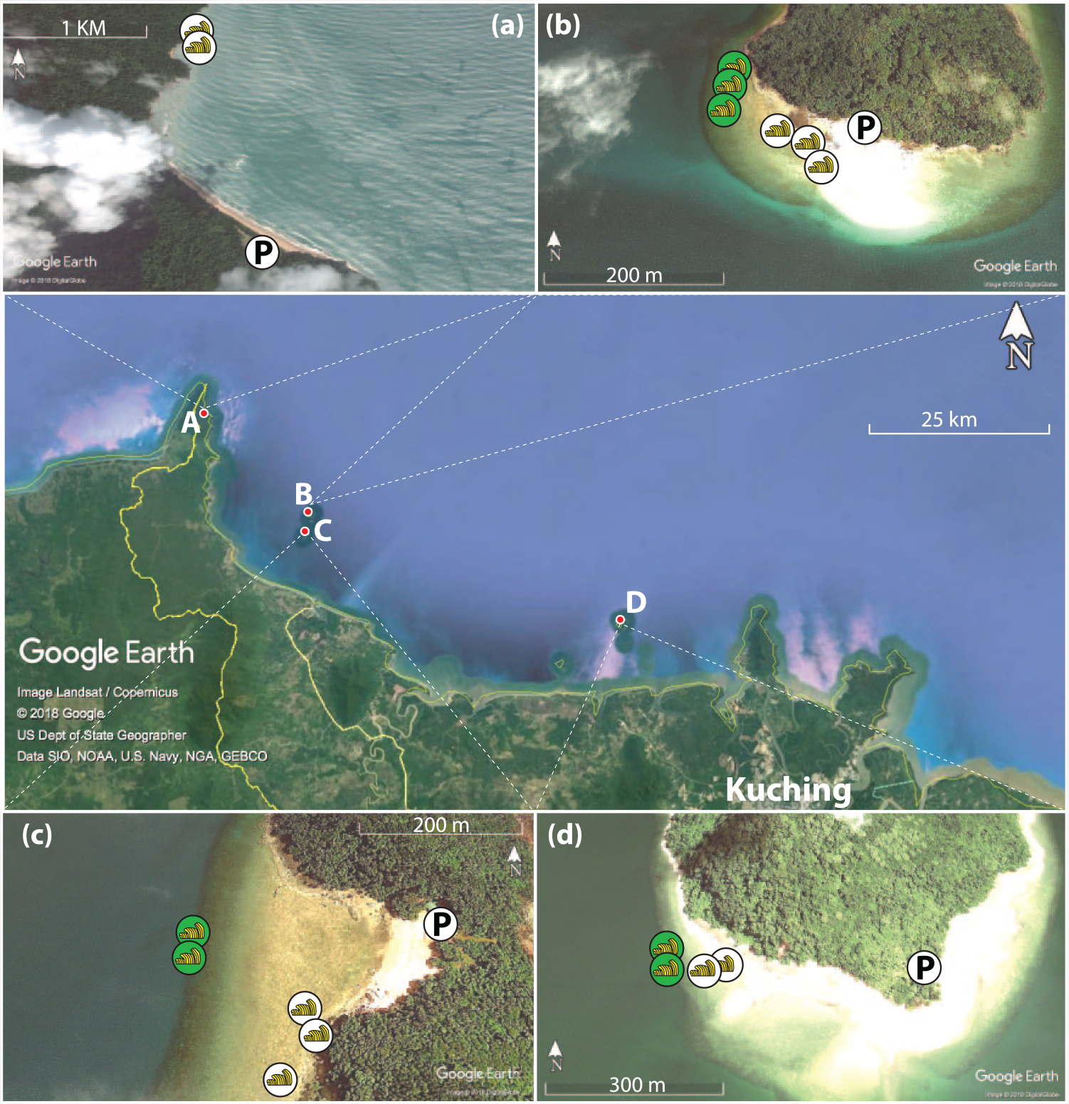
Map and imagery of study sites in western Sarawak. Central strip shows the site locations in relation to Kuching, the capital of Sarawak. Individual panels show coral microatoll locations at each of the studied sites. For fossil corals, individual microatolls are labeled. Living microatoll symbols represent multiple colonies surveyed in one area. Panel (a): Tanjung Datu, Panel (b): Talang Besar, Panel (c): Talang Kecil, and Panel (d): Satang Besar.
The fourth site (Tanjung Datu) is on the Tanjung Datu peninsula, western Sarawak, approximately 21 km northwest of the Talang Islands (Figure 1 inset). Unlike the three island sites, the fringing reefs at Tanjung Datu face northeast. During our field campaign, waves and turbid conditions prevented detailed survey of living corals. Like the other three sites, the microatolls here are established directly on solid rocky substrate, and reef zonation and structure appear to be similar to those found at the island sites. Unlike the other sites, the reef flat at Tanjung Datu is relatively narrow (i.e. limited platform for horizontal coral growth). Coelastrea aspera and soft corals grow highest along the shoreline and are hence exposed first during low tides, followed by Porites spp. microatolls seawards toward the edge of the reef flat. All sites are located away from large rivers and on the seaward edges of the reef flats, ensuring an abundance of well-preserved microatolls from which RSL histories can be reconstructed.
Reconstruction of RSL
Coral microatolls
Fossil coral microatolls are an accurate and precise RSL indicator (Meltzner and Woodroffe, 2015; Scoffin et al., 1978), and have been applied globally (Nunn and Peltier, 2001; Smithers and Woodroffe, 2000; Woodroffe and McLean, 1990; Woodroffe and Murray-Wallace, 2012) and regionally in the South China Sea (Azmy et al., 2008; Mann et al., 2016; Meltzner et al., 2017; Yu et al., 2009) to produce sea-level index points (SLIPs). A coral microatoll is formed when a coral colony reaches a vertical growth limit constrained by a combination of exposure to ultraviolet (UV) light, heat, and desiccation during low tides (Brown et al., 1994; Scoffin et al., 1997, 1978). The level up to which a coral microatoll grows, and above which its polyps die during low water, is called the highest level of survival (HLS). If polyp death occurs at a uniform elevation around the perimeter of the microatoll, it is a indication that it was caused by low water levels (Meltzner and Woodroffe, 2015; Meltzner et al., 2017; Taylor et al., 1987). While the upper surface of the coral dies and vertical growth is halted, horizontal growth continues, over time producing a variable surface morphology (Meltzner and Woodroffe, 2015).
The exact morphology of the upper surface of a microatoll is controlled by RSL, and change over time in HLS is a proxy for change over time in RSL. If RSL is rising, the coral polyps will be vertically unconstrained and will grow upward until they are limited again. Microatolls growing during periods of rising RSL tend to have lower centers (the oldest part of the coral) and higher outer rings, and vice versa under conditions of falling RSL. If water levels remain stable, the microatoll will tend to form a flat surface. Microatolls can continue recording the RSL for decades or centuries as long as there is accommodation space for their continued growth. Using fossil microatolls, it is possible to reconstruct RSL change by comparing the elevation of living and fossil specimens at the same site, in the same manner as other fixed biological indicators (Laborel and Laborel-Deguen, 1996; Rovere et al., 2015).
Superimposed on the long-term RSL trends are periodic fluctuations in the lowest tides that are related to the 18.6-year nodal tidal cycle. In places where the nodal tidal cycle is significant, these fluctuations result in concentric rings on a microatoll’s upper surface (Meltzner et al., 2017).
HLS is influenced by the physiology of the coral, wind, insolation, ponding, and other factors which affect coral polyp survival during low tides (Brown et al., 1994; Scoffin et al., 1997). Because of these influencing factors, HLS is not uniform throughout a reef but rather exhibits a range. This range is site specific due to complexity of the reef and tidal range (Smithers and Woodroffe, 2000). Ponding refers to instances whereby coral microatolls growing in lagoons and ponds are cut off from the open sea for the low part of the tidal cycle and are therefore protected from the lowest water levels. As a consequence, the growth patterns of these ponded microatolls do not reflect the full tidal cycle and sea level, but rather record the water level changes of the pond or lagoon in which they are growing (Scoffin et al., 1978).
Field surveys
We selected 27 living and 10 fossil massive Porites. microatolls from our four field sites to reconstruct RSL. All fossil microatolls grew directly on hard substrate and did not appear to be shifted or tilted. Locations of selected fossil and modern microatolls were determined using a Garmin GPSMAP 64 global positioning satellite system. Elevations of the surface morphology of the living and fossil microatolls at all three island sites were surveyed using a Leica TCRP1203 total station. Fossil microatolls from each site are only compared with living microatolls on the same site and not compared with the tidal datum. This procedure can be used when RSL is to be reconstructed only from one proxy and where modern counterparts to fossil evidence are present at each site (Meltzner and Woodroffe, 2015; Shennan, 2015; Woodroffe and Barlow, 2015). The microatolls from Tanjung Datu were surveyed with a low-tech method devised by Emery (1961) using measuring staffs and the horizon as a back sight. The errors of the method were investigated by Krause (2004) who concluded that at short distances (<60 m) the accuracy is similar to instrumental, ±1 cm. In our case, the measurement was indeed made over a short distance of roughly 30 m.
U–Th dating of microatolls
We collected a ~10 cm long core (2 cm diameter) from the top surface of each targeted fossil microatoll. The cores were then fragmented and the cleanest, deepest part of the cores were sampled for U–Th dating. The degree of recrystallization was determined using a microscope; only samples that did not have visible recrystallization were used. All samples underwent ultrasonic cleaning at least three times in deionized water before further chemical cleaning. Procedures for chemical separation and purification of uranium and thorium are similar to those described by Edwards et al. (1986) and Cheng et al. (2000). The samples were dated at the Earth Observatory of Singapore, Nanyang Technological University, on a Finnigan NEPTUNE plus MC-ICPMS following the procedures by Cheng et al. (2013). We calculated corrected 230Th ages using an initial 230Th/232Th value of 6.5 ± 6.5 × 10⁻⁶ (atomic ratio) (Shen et al., 2008). This number is applicable to most of the corals in continental shelf settings (Clark et al., 2012; Shen et al., 2008). All the secondary electron multiplier biases, spectral interferences, chemistry and instrumental blanks, and corrections for spike composition are calculated in an off-line data reduction process (Cheng et al., 2013). Uncertainties in the U–Th isotopic data and 230Th dates are calculated at 2σ level or two standard deviations of the mean; details of U–Th dates are shown in Table 1 and Supplementary Table 1, available online.
Summary of U–Th age results and HLS observations in relation to living coral microatolls.
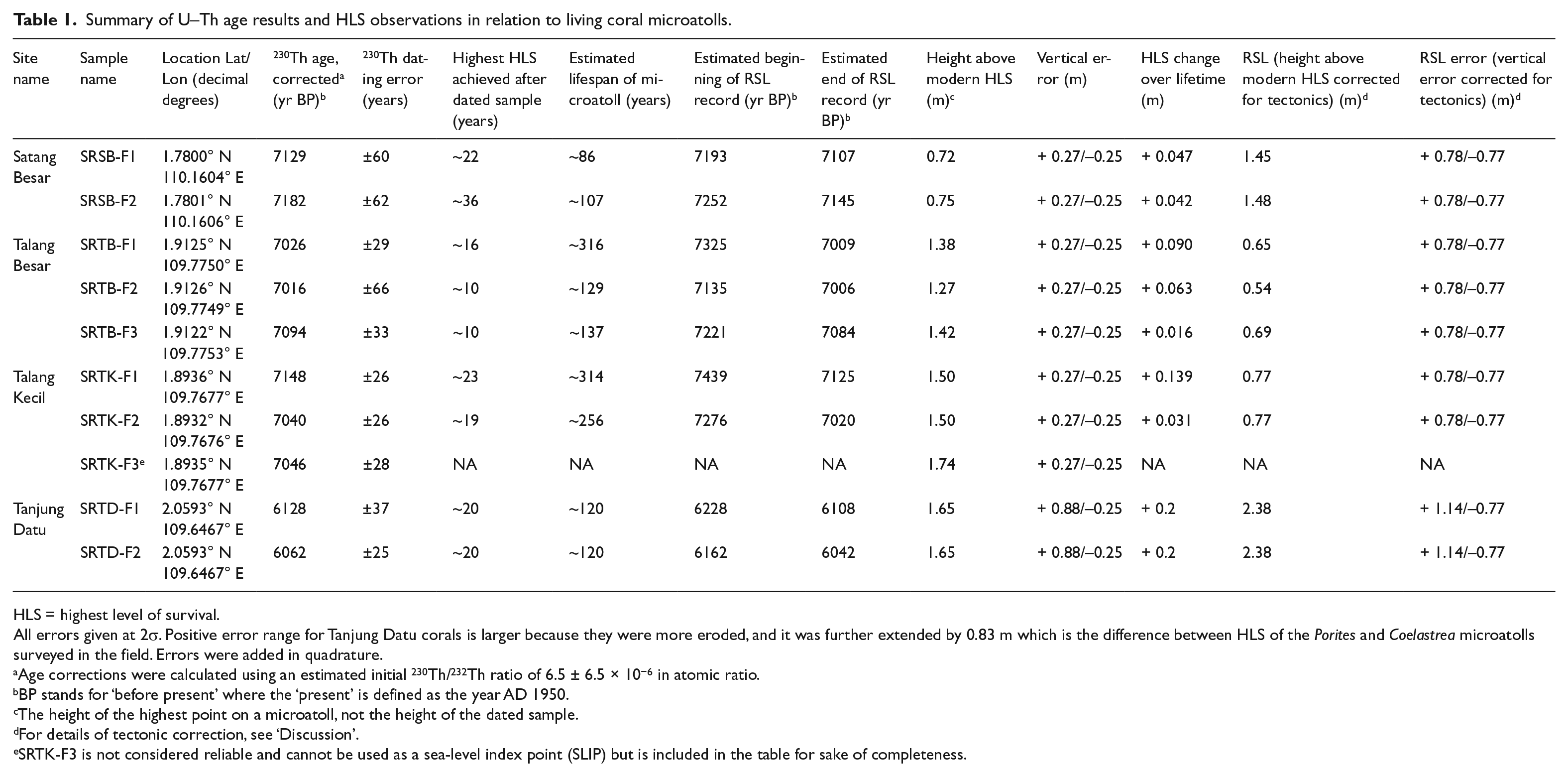
HLS = highest level of survival.
All errors given at 2σ. Positive error range for Tanjung Datu corals is larger because they were more eroded, and it was further extended by 0.83 m which is the difference between HLS of the Porites and Coelastrea microatolls surveyed in the field. Errors were added in quadrature.
Age corrections were calculated using an estimated initial 230Th/232Th ratio of 6.5 ± 6.5 × 10⁻⁶ in atomic ratio.
BP stands for ‘before present’ where the ‘present’ is defined as the year AD 1950.
The height of the highest point on a microatoll, not the height of the dated sample.
For details of tectonic correction, see ‘Discussion’.
SRTK-F3 is not considered reliable and cannot be used as a sea-level index point (SLIP) but is included in the table for sake of completeness.
Determining RSL from HLS
To reconstruct RSL, the HLS must be measured on both fossil and living microatolls at any given site. The difference in elevation between fossil and living HLS is then used as a proxy for past RSL. However, since HLS is also influenced by factors other than RSL that affect coral polyp survival during low tides (e.g. coral physiology, wind, insolation, ponding), a range of values for HLS is usually found for a reef (Brown et al., 1994; Scoffin et al., 1997). To minimize the likelihood of including ponded living microatolls in our study, we selected only microatolls along the outside edge of the reef flat, that is, where the reef crest begins. The average HLS elevations of living Porites. microatolls were measured at Satang Besar ±0.10 m (2σ, n = 10), Talang Besar ± 0.18 m (2σ, n = 7), and Talang Kecil ± 0.11 m (2σ, n = 10), which was compared with the elevations of fossil microatolls at each respective site. At Tanjung Datu, we were unable to locate living Porites microatolls. Instead, we measured the elevation of the fossil Porites. in relation to a living microatoll of Coelastrea aspera. On all three island sites we surveyed, Coelastrea aspera corals consistently grew higher than any open-water Porites. microatolls. Therefore, the difference between fossil Porites. HLS and living Coelastrea aspera HLS provides a minimum value for past RSL at Tanjung Datu. Differences in HLS of different coral species have also been reported by Scoffin et al. (1997), Natawidjaja et al. (2006), Meltzner and Woodroffe (2015), and Meltzner et al. (2017).
We present the uncertainty in RSL from HLS data from several sources, which were added together in quadrature. We did not have sufficient HLS measurements at each site to conduct a full statistical analysis; therefore, we conservatively applied a wider vertical error of ±0.18 m (2σ) calculated by Meltzner et al. (2017) for living microatolls on Belitung Island, Indonesia, 600 km to the southwest. We counted this variability in HLS (±0.18 m) twice due to the fact that it applies both to living and to fossil microatolls, and added an additional uncertainty to account for surveying precision (±0.01 m 2σ). Fossil microatolls are commonly eroded after their death. However, we selected microatolls with clear ring structure (e.g. Figure 6) and, therefore, conservatively estimated the error to be 0.10 m for all microatolls from Satang Besar, Talang Besar, and Talang Kecil islands. A value of 0.15 m was used for the two Tanjung Datu microatolls, because they were more weathered. Erosion uncertainty was only added to the positive elevation error resulting in asymmetrical ranges. The coral microatolls are considered compaction free because they grew directly upon bedrock. Errors are listed in Table 1 and shown in Figure 4.
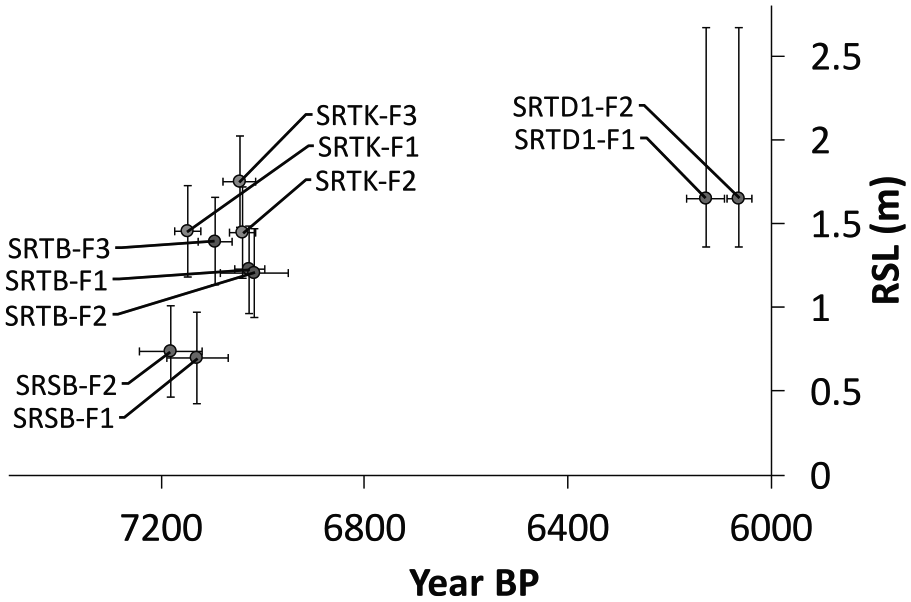
Age and relative sea level (RSL) inferred from each of the 10 coral microatolls sampled in the study.
Predictions of RSL
Bradley et al. (2016) extended a previously published global ice sheet model (Bassett et al., 2005), which was unconstrained from 10,000 yr BP to present. The new model was developed by comparing RSL predictions from the GIA model with SLIP data from China and the Thai-Malay Peninsula. Data-model misfits were examined for a range of eustatic sea-level scenarios and earth model parameters. The model is characterized by a slowdown in melting at ~7000 yr BP, associated with the final deglaciation of the Laurentide Ice Sheet, followed by a continued rise in eustatic sea level until ~1000 yr BP of ~5.8 m associated with melting from the Antarctic Ice Sheet. We chose to look at RSL predictions for seven earth models in the following range: (1) lithospheric thickness of 96 km; (2) upper mantle viscosity values from 1 × 10²⁰ to 1 × 10²¹ Pa s; and (3) lower mantle viscosities of 1 × 10²¹ to 5 × 10²² Pa s (Table 2).
Parameters of the six Earth models chosen for comparison with data.
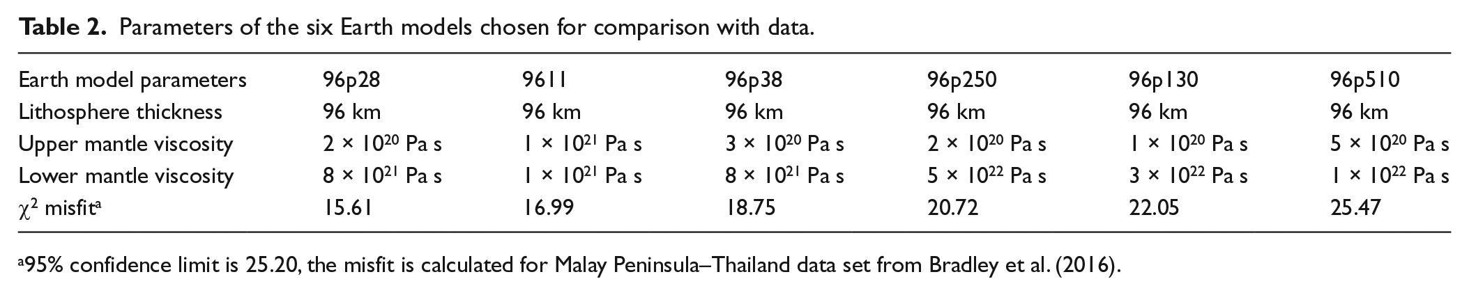
95% confidence limit is 25.20, the misfit is calculated for Malay Peninsula–Thailand data set from Bradley et al. (2016).
We predicted RSL for the four study sites. The Talang Besar and Talang Kecil islands are treated as one region, because of their proximity to each other, whereas Satang Besar and Tanjung Datu are predicted separately. We then compare the model predictions for the four sites with the RSL proxy results. GIA predictions of the Bradley et al. (2016) model are given as changes in RSL allowing them to be directly comparable with RSL reconstructed from the microatolls.
Results
Age and elevation of dated samples
Age and elevation reconstructions of fossil coral microatolls are based on the elevation of dated samples from each microatoll compared with HLS of living open-water Porites microatolls at the same site (Figure 4, Table 1).
Our samples from west Sarawak plot in clusters for coral microatolls from each island (Figure 4). The Satang Besar samples have the oldest ages of the study dating to 7182 ± 62 and 7129 ± 60 year BP and their HLS were measured at 0.73 and 0.69 m, respectively. Talang Besar coral microatolls were dated to between 7094 ± 33 and 7016 ± 29 year BP, but plotted higher than the Satang samples, with HLS between 1.20 and 1.39 m. The samples from Talang Kecil plot close in age to the Talang Besar samples, although at slightly higher elevation, between 1.5 and 1.7 m and dating to between 7148 ± 26 and 7040 ± 27 year BP. Finally the Tanjung Datu samples were younger than the other sites, dating to 6128 ± 37 and 6063 ± 25 yr BP. They also showed the highest elevation of the four sites with both samples surveyed at 1.65 m > HLS on Coelastrea aspera.
Fossil microatoll RSL history and lifespan reconstruction
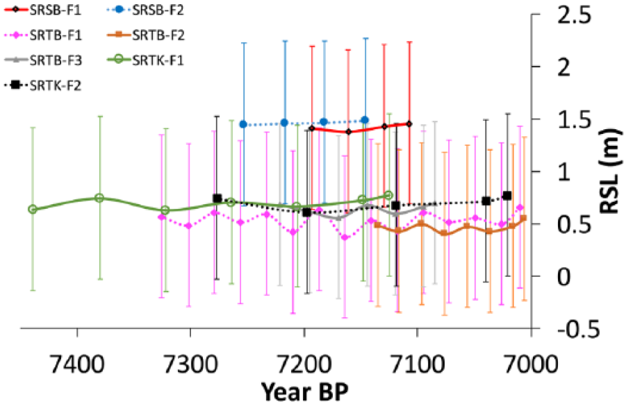
The RSL history and lifespan of each Porites microatoll was estimated based on detailed surveys of the microatoll surface, and an average linear growth rate of 1 cm/yr as measured from several modern massive Porites colonies cored from the Talang Besar and Tanjung Datu study sites. An additional growth rate check was conducted on sampled fossil cores which, on average, do not differ widely from the growth rate estimated from modern corals. The dated samples were taken near the highest and youngest portion of each microatoll, and an estimate of the difference (in years) between the dated part of the microatoll and the point of highest growth is given (Figure 5, Table 1). These differences are generally a few decades or less. The microatolls at Talang Besar, and perhaps at other sites as well, show regularly spaced concentric rings that occur roughly once every two decades; this would be consistent with influence from the 18.6-year nodal tidal cycle. Similar influence is seen elsewhere on the Sunda Shelf (Meltzner et al., 2017).
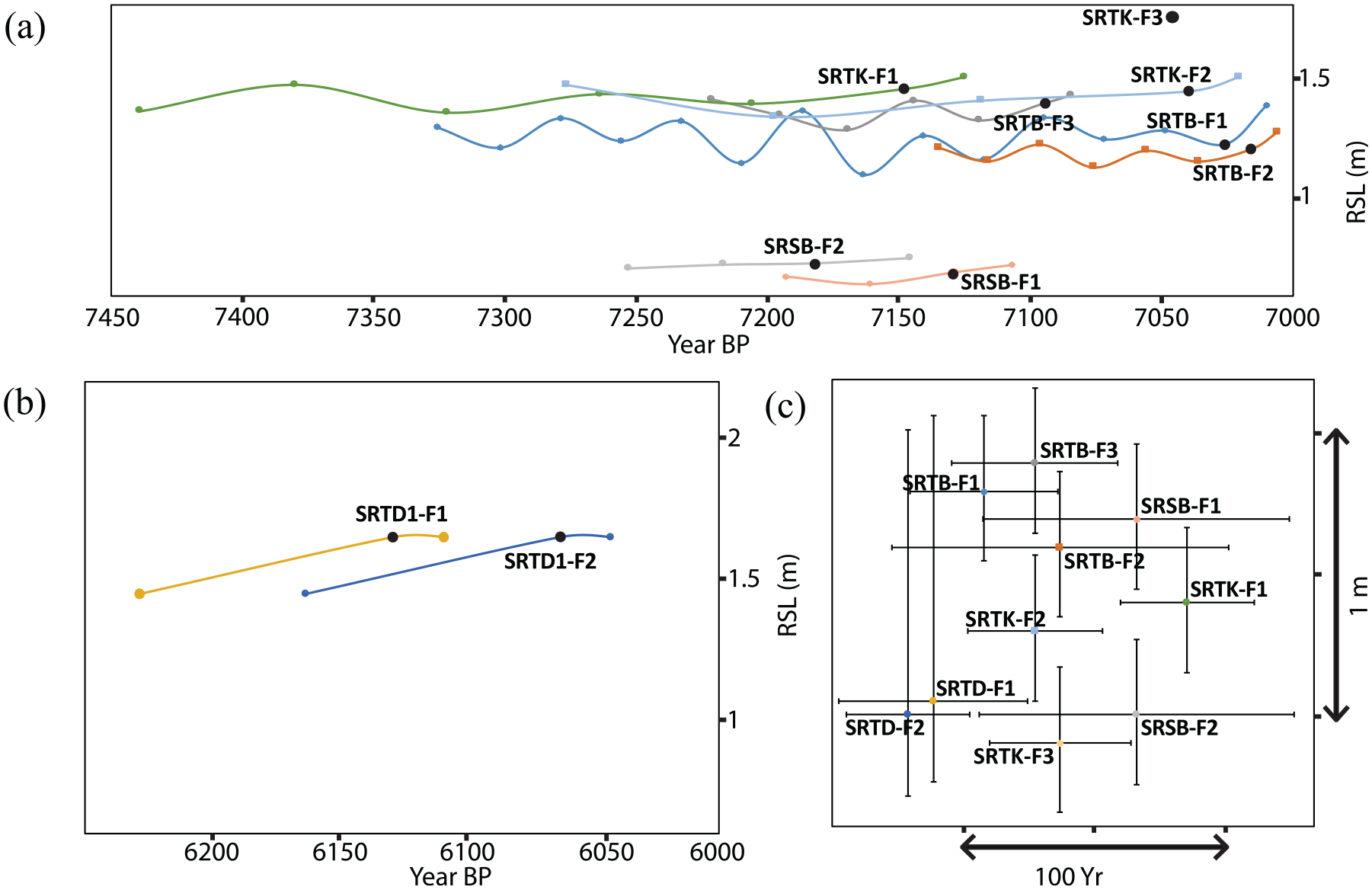
Relative sea-level (RSL) plots of 10 fossil microatolls from Sarawak, based on one dated sample from each microatoll (marked with black circles on panels (a) and (b)), a detailed total station survey of each microatoll, and an estimated growth rate of 1 cm/y. Panel (a) shows the older time series from Satang Besar (SRSB), Talang Besar (SRTB), and Talang Kecil (SRTK). Panel (b) shows the younger time series from Tanjung Datu (SRTD). To illustrate the error bars for each curve while maintaining legibility of panels (a) and (b), we plot the size of the 2σ error bars for each time series separately in panel (c); the scale is the same on all three panels. The chronological errors are those that arise from the U–Th dating technique; the vertical errors are those that arise in inferring RSL from the HLS proxy data. The error shown for each microatoll applies uniformly as an absolute error to the microatoll’s entire time series as a whole; the relative chronological and vertical errors between individual points on the same curve in panel (a) or panel (b) are smaller than the errors shown in panel (c).
Samples from Satang Besar grew for 86 and 107 years, while their HLS showed little net change, gaining 0.05 and 0.04 m over their respective lifetimes. At Talang Besar, the corals spanned longer periods, growing for 129 and 137 years, and 316 years in the case of the biggest microatoll, SRTB-F1 (Figure 6). The Talang Besar microatolls also showed minimal net change in HLS elevation over their lifetimes, increasing by 0.06, 0.02, and 0.09 m, respectively. Further south, two coral microatolls from Talang Kecil also grew for long periods of time, for 256 and 314 years, gaining 0.02 and 0.14 m over their lifetimes. The highest sample from this site (SRTK-F3) was largely buried and as such, a reconstruction of its lifespan or change of HLS was not possible. The Tanjung Datu corals, which were approximately 1000 years younger than those at the other sites, grew for 120 years each, gaining 0.2 m over their lifetimes. For more details of microatoll RSL history and lifespan, see Supplement A, available online.
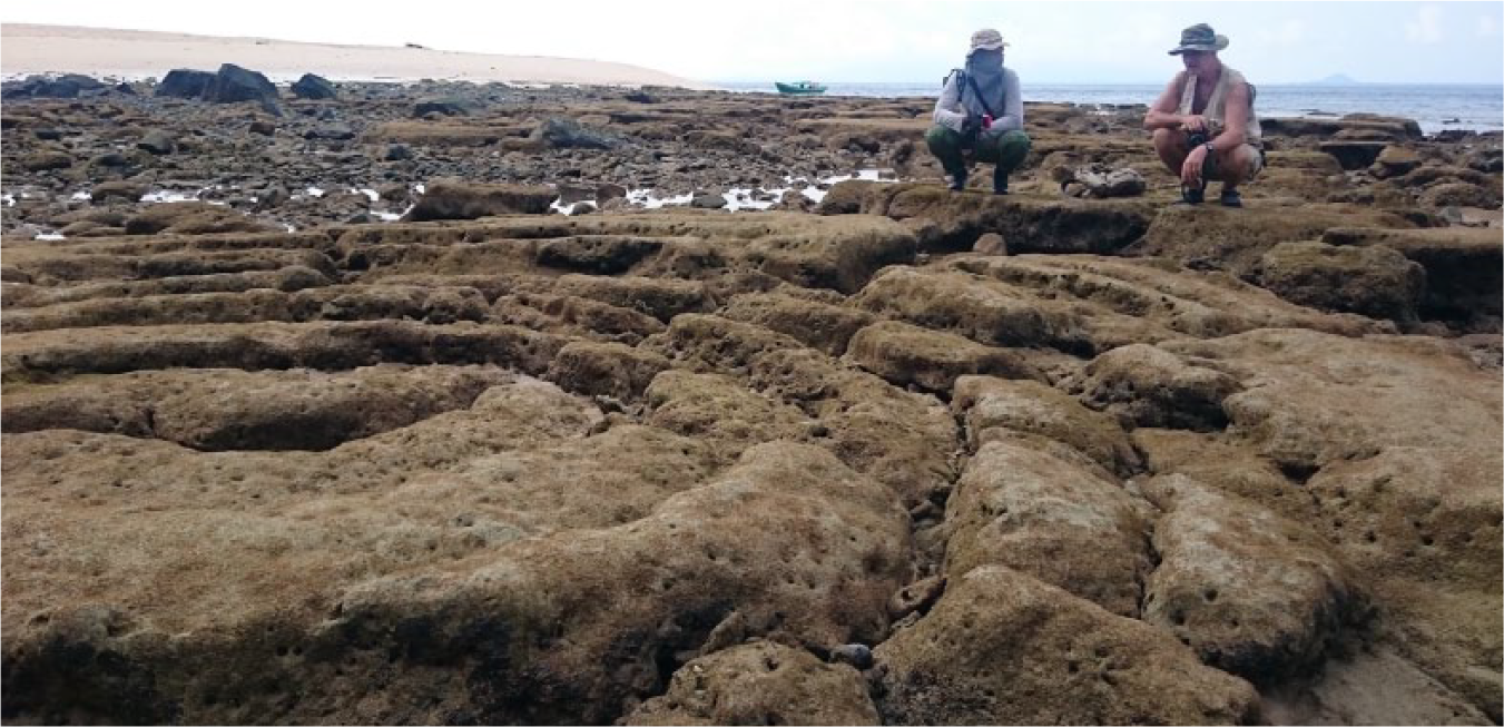
A 6-m-wide fossil microatoll (SRTB-F1) on Talang Besar Island shows clear rings resulting from many successive diedowns, inferred to be driven by the 18.6-year tidal cycle (Meltzner et al., 2017). Note that the outer rings are slightly higher than the center. A U–Th age of 7026 ± 29.1 yr BP (before AD 1950) was obtained from the outer ring. With a growth rate of ~1 cm/yr this microatoll likely holds a RSL record spanning ~320 years.
Model prediction results
The GIA model shows the influence of continental levering on RSL across the region. At 7000 yr BP, the model predicts a gradient in RSL with Tanjung Datu in the west being the lowest and Satang Besar in the east being the highest (Figure 7). The predictions for a range of earth models show RSL rising steeply up to 7000 yr BP, slowing thereafter, and peaking at 5000 yr BP with an elevation of 0.80–3.10 m above present (Figure 8). At 7000 yr BP, a height of −1.00 to 0.75 m is predicted for the Talang Islands, and −0.30 to 1.55 m is predicted for Satang Besar. The RSL height at Tanjung Datu at 6000 yr BP is predicted to have been −0.25 to 1.70 m.
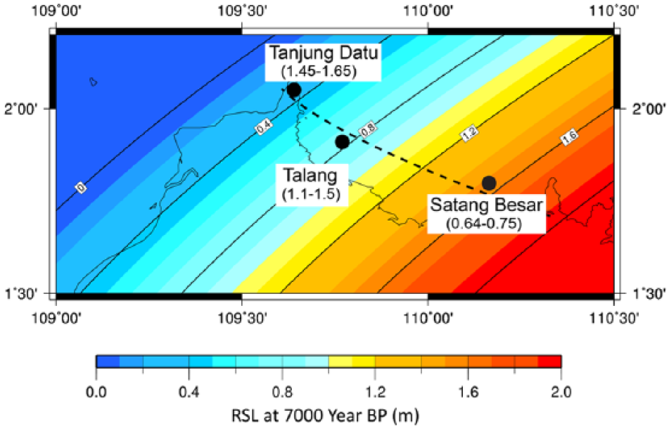
Relative sea-level (RSL) predictions for west Sarawak at 7000 yr BP, based on Earth model 96p510 (parameters in Table 2). Model (predicted) RSL heights are labeled along the gradient lines. The range of RSL heights inferred from coral microatolls, in meters and excluding uncertainties, are given in parentheses under the name of each site. RSL height increases from the northwest (Tanjung Datu) toward the southeast (Satang Besar), which is opposite to inferences from fossil microatolls. Dashed line marks approximate location of the Serabang fault. Tanjung Datu observations are given for completeness but are ~1000 years younger than the modeled RSL gradient.
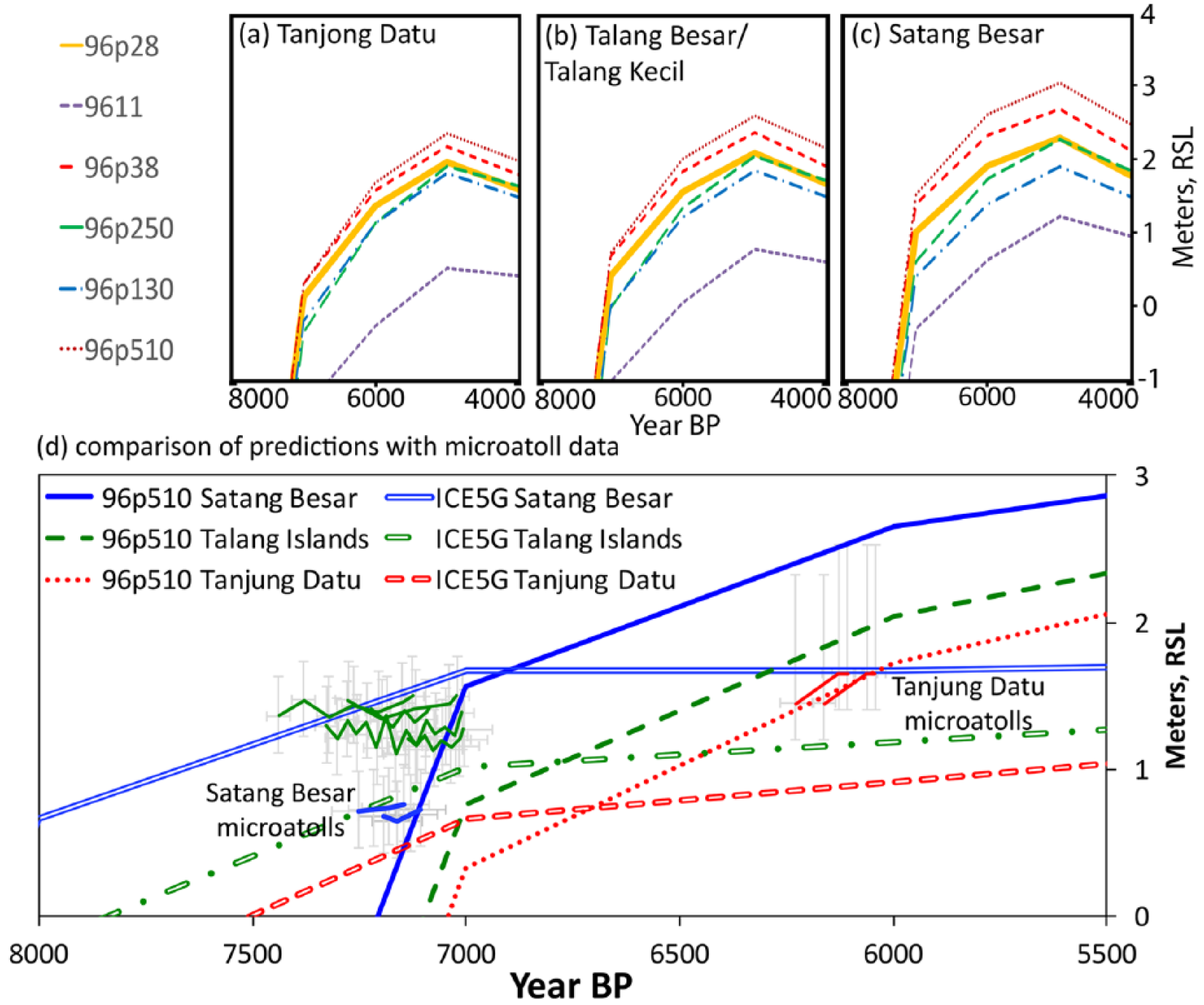
A comparison of relative sea-level (RSL) proxy data from microatolls with model predictions for each of our three site locations. Panels (a), (b), and (c) show a full range of earth model predictions for each site using the Bradley et al. model. Panel (d) shows a comparison of the microatoll data from the three sites to RSL model predictions from the Bradley et al. and ICE5G GIA model combined with the 96p510 earth model. Note the approximate agreement of microatoll observations and RSL predictions for the Satang Besar and Tanjung Datu sites and the discord between predicted and reconstructed RSL from the Talang islands. Also, note the rapid RSL rise predicted prior to 7000 yr BP, which is inconsistent with the microatoll proxy data.
Discussion
Differences in elevation between sites
All the GIA model scenarios considered in the study predict that RSL of fossil microatolls will be highest on the Satang site, lower on the Talang sites, and lowest at Tanjung Datu (Figure 7). However, when we compare elevation data between sites (Figures 4 and 5 and Table 1), the opposite trend is reconstructed. Satang Besar is predicted to have the highest RSL at 7000 yr BP, and, if the model is correct, it should be higher than the Talang sites regardless of which earth model parameters are assumed. The 96p510 earth model, which is the closest fit to our data, predicts Satang Besar to be ~0.75 m higher than the Talang sites, but instead our microatolls indicate RSL at Satang was actually ~0.7 m lower than at the Talang sites. The combined discrepancy of ~1.45 m requires an explanation. In general, we assume the model predictions provide accurate spatial trends in RSL. While predicted changes in RSL due to GIA may be over- or underestimated by models, it is unlikely the slope in GIA is opposite to that which is predicted by the model (Figure 7). Even if we assume no differences in GIA between the four sites, the 0.7 m offset between reconstructed RSL from the four sites still requires an explanation.
At some sites, spatial differences in RSL have been attributed to local factors such as tidal range change, ponding, or geoidal gradient. Conducting a study on Christmas Island, Woodroffe et al. (2012) found differences of as much as ~0.6 m in the height of tides and fossil microatoll elevation above their living counterparts between sites ~30 km apart. The differences were consistent with a strong geoidal gradient over the study area. However, in their study, the microatoll elevations were compared with the same benchmarks over large distances. In our study, fossil microatolls are only compared with living counterparts from the same site and a geoidal gradient cannot explain the differences in elevation between sites. Similarly, tidal range change is minimal among sites. Modeling by Meltzner et al. (2017) in Belitung (also on the Sunda shelf) showed that if RSL was 2 m higher than present, the low tide would have been ⩽ 10 cm different than at present.
Ponding is a possibility that should be investigated at any microatoll site, both for living and fossil specimens. In a ponded setting, microatolls grow higher than in the open sea, giving false information about RSL and its change over time (Majewski et al., 2015; Scoffin et al., 1978). As a result, ponding can impact the accuracy of comparisons between living and fossil microatolls. We investigated the possibility of ponding of the fossil microatolls at Talang Besar and Talang Kecil since erosion might have removed barriers of sand, shingle, or other corals that once protected the fossils from the open sea. If this was the case, it would make the RSL proxies from these sites appear higher than RSL was in reality. While the Talang Kecil microatolls grew at the back of the reef flat, where corals are more prone to ponding (Scoffin et al., 1978), our survey of their upper surface revealed large vertical changes (>10 cm) between the highs and lows of the ring structure. In contrast, our observations of living microatolls in Sarawak and at sites in Indonesia suggest that ponded microatolls tend to have a flatter morphology, experiencing smaller but more frequent diedowns than open-sea microatolls (Majewski, 2018). Therefore, we argue that SRTK-F1 and SRTK-F2 on Talang Kecil were unlikely to have been ponded. As noted earlier, however (Table 1), SRTK-F3 was measured to be 24 cm higher than the other two microatolls on this site and further landward. This leads us to believe SRTK-F3 was likely to have been ponded. Unfortunately, SRTK-F3 was largely covered with sand and boulders during our field visit, which prevented us from examining its morphology. Hence, SRTK-F3 was excluded from further analysis.
On Talang Besar, the fossil microatolls exhibit clear ring structure with rings ~0.2 m apart, which would be in agreement with an 18.6-year tidal cycle modulation if a typical growth rate of ~0.01 m/yr is assumed, as was measured to be the case with living Porites sp. coral at the site. This would suggest these microatolls grew in open water. They also grew closer to the seaward edge of the reef than the microatolls on Talang Kecil, which suggests that ponding is even less likely on this site. We therefore conclude that ponding of fossil microatolls on the Talang sites is unlikely to be the explanation for the difference between predictions and observed data.
If ponding of fossil microatolls is not the answer, could ponding of living microatolls be the cause? If living microatolls were ponded, their observed elevations would be higher than HLS of open-water microatolls, and the apparent elevation of the fossil microatolls (relative to the ponded living HLS) would be biased low. However, ponding is easier to recognize in living microatolls than in fossils, and we have paid particular attention to ponding, picking living microatolls for comparison only from the outer edge of the reef crest with no barrier between them and the reef slope. Hence, we surmise that this possibility is also unlikely.
Having ruled out local processes, we postulate that the observed differences in RSL are due to tectonic deformation, specifically vertical displacement along a fault. Although western Sarawak is considered to be tectonically stable (Simons et al., 2007), tectonic movement occurred on several faults in the region during the Lower Cretaceous (~100 myr) (Haile, 1973; Hall et al., 2008; Hutchison, 1975, 2014). The closest of these is the Serabang Line (Figures 1 and 7), as mapped by Hutchison (2005), which may be a western extension of the better-known Lupar Line (Liu et al., 1999). The location is only approximate and is based on early studies of the Serabang Formation on Tanjung Datu (Hutchison, 1973, 1975). Few details regarding this feature are available, though Haile (1973) postulated it to be a Lower Cretaceous subduction zone. A more recent geological and geophysical study (Williams et al., 1988) supports Haile’s (1973) hypothesis of a former Cretaceous subduction zone in Sarawak. Further support comes from a model of the build-up of Borneo published by Hall et al. (2008). Alternatively, Mazur et al. (2012) and Zahirovic et al. (2014) both interpret the Lupar and/or Serabang line as either a suture zone or an inactive fault. These studies argue for the existence of a former subduction zone in western Sarawak, but none of the studies have suggested present-day activity on the Serabang or Lupar lines. We postulate that the 1.45 m differential between our sites results from a reactivation of fault motion along the Serabang Line. If this is true, it is perhaps not surprising that such motion has until now gone unrecognized. Evidence for limited recent movement along this structure would have likely been missed by the aforementioned studies due to the fact that they focused primarily on bedrock, whereas young fault movement is typically best recognized in Holocene deposits. Similarly, Simons et al. (2007) would have been unlikely to resolve deformation along the fault since the vertical displacement rates required to produce an offset of 0.7–1.45 m over a period of 7000 years would have been within the noise, given that these GPS arrays have an accuracy of ~1 mm/yr (Simons et al., 2007).
Having established the most likely explanation for the unexpected offset between our sites to be tectonic deformation, one question is, why was the fault reactivated? We propose that the fault may have been reactivated due to changes in the stress field resulting from the flooding of the Sunda Shelf following the Last Glacial Maximum. During the rapid sea-level rise in the early Holocene, large parts of the Sunda Shelf were flooded, and the added hydrostatic load depressed and flexed the lithosphere viscoelastically. The lithospheric stresses induced by this flexure have been modeled by Luttrell and Sandwell (2010), and they showed that rupture of faults near the coastline can be promoted through a reduction in normal stress. Neves et al. (2015) reported similar results but showed that the magnitude of the stress change depended upon the geometry of the fault in question. Although there is currently insufficient information about the geometry of the inferred Serabang fault to attempt such analysis, the above-mentioned studies demonstrate the plausibility of Holocene reactivation of the Serabang fault due to rising sea level.
Another question posed by the implication of tectonic movement is, where did most of the movement occur? A detailed plot of predicted RSL for all sites in this study (Figure 8) reveals that RSL observations from microatolls at the Tanjung Datu site and the youngest microatolls at the Satang Besar site plot within error of predicted RSL for their age and locations, for a subset of reasonable earth models. In contrast, the RSL observations from the microatolls on the Talang Islands consistently plot ⩾ 0.5 m above the predictions. Therefore, if the model predictions are correct, they suggest that the southern side of the proposed Serabang fault, including the Talang sites, has been uplifted.
The relative displacement of between 0.7 m and 1.45 m between the Talang sites and Satang Besar can only be plausibly explained by tectonic deformation. This deformation must have occurred sometime after the corals lived and died. Therefore, our data strongly support our postulation that movement on the Serabang fault has occurred in the past 7000 years. Although our results are speculative, the Serabang Line passes offshore the state capital of Sarawak, Kuching, a city with more than half a million residents. Our data are consistent with the mapped trace of Hutchison (2005) as a trajectory of the fault. Therefore, the seismic potential of this region may be underestimated, and current building ordinance for the State of Sarawak, while making provisions for fire and flooding hazards, makes none for earthquakes (Sarawak State Assembly, 2008).
The influence of GIA
Because of the likelihood of tectonic displacement in the study area, the spatial variability of RSL (Figures 4 and 5) does not reflect GIA alone. In order to estimate the contribution from GIA, we need to correct for tectonic effects. We assume the vertical displacement along the proposed Serabang fault is divided evenly between the two sides, and we add, in quadrature, 2σ elevation errors equivalent to half of the estimated maximum tectonic displacement of 1.45 m. For simplicity, we plot the data from the Satang and Talang sites with data from the Satang site shifted up by 0.73 m and data from the Talang sites shifted down by 0.73 m (Figure 9). This procedure extends the error bars, but allows us to estimate RSL at both sites without the tectonic influence. Tanjung Datu is on the northern side of the inferred Serabang fault, along with the Satang site. Although we do not have concurrent microatoll growth at other sites, we have nonetheless made a tectonic correction for the Tanjung Datu corals, just as we did for the Satang corals (Table 1). Because Tanjung Datu microatolls are younger than those at the Talang and Satang sites, any movement that affects Tanjung Datu should be equal to or smaller than that between Talang and Satang.
Fossil microatoll relative sea-level (RSL) data from the Satang and Talang sites, showing remarkable stability for a period of ~450 years. These data have the inferred tectonic signal removed, with the wider vertical errors accounting for uncertainty in which side of the proposed Serabang fault went up or down in an absolute sense. It is important to note that the error bars represent absolute errors about each point; relative vertical errors between all points are substantially smaller. Temporal errors are unchanged from Figures 3 and 6.
After adjusting for tectonics and propagating uncertainties, we note a general inconsistency between the GIA models (Bradley et al., 2016) and proxy RSL observations in Sarawak: whereas all models suggest rates of RSL rise exceeding 7 mm/yr prior to 7000 yr BP and rates of 1 mm/yr or greater from 7000 to 6000 yr BP (Figure 8), the observations suggest comparatively stable RSL just prior to 7000 yr BP. The inference of near RSL stability (e.g. ~0.09 m of RSL rise over ~316 yr, as recorded by SRTK-F1) is robust: the extended period of limited RSL rise is captured in individual fossil microatoll records (Figure 5) and is reproducible on multiple microatolls at multiple sites. It could be suggested that apparent RSL stability in coral microatolls could be caused by RSL rise due to GIA being balanced by interseismic tectonic uplift. However, a near identical match of uplift rates and rates of RSL rise due to GIA would require a remarkable coincidence. Furthermore, it is difficult to conceive of a mechanism by which both sides of the fault would have simultaneous interseismic uplift. We, therefore, consider this idea to be unlikely.
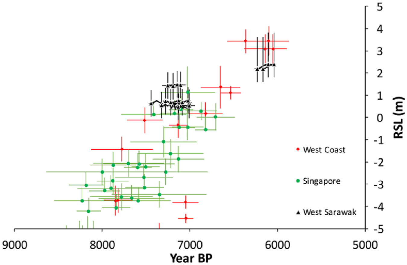
The microatoll evidence suggests that the RSL rise on the Sunda Shelf slowed earlier than modeled (Bradley et al., 2016) and earlier than seen in most published studies from the Sunda Shelf (Horton et al., 2005, and references therein). The only studies from the Malay Peninsula to show RSL stability prior to 7000 yr BP are those by Bird et al. (2007, 2010) from Singapore. The Bird et al. data show an earlier period of stability, between 7800 and 7400 yr BP; however, with many of the SLIP data in the Bird et al. studies having large chronological and elevation errors, and with our data spanning only the periods 7450–7000 and 6100–6000 yr BP, it is difficult to compare the timing of the periods of stability at the Sarawak and Singapore sites. Rather, our highest RSL observations date to ~6000 yr BP (Figure 10), similarly to other sites including Kelang (Kamaludin, 2002) and Phuket (Scoffin and Le Tissier, 1998). A plot of Malay Peninsula and Singapore data from 10,000 yr BP to present (Figure 2) shows that with the exception of three high points around 5000 yr BP (Geyh et al., 1979), both east and west coasts appear to reach a highstand between 7000 and 6000 yr BP, and experience falling RSL thereafter.
Relative sea-level (RSL) history of the Malay Peninsula (from Figure 2) with data from west Sarawak added. Note the period of stability between 7450 and 7000 yr BP. Sarawak data appear to be closer in elevation to the eastern coast of the Malay Peninsula, although the error bars allow some ambiguity, particularly for the data around 6000 yr BP. For reasons of clarity, each fossil microatoll series plotted only as a beginning and an end point. Note that error bars of the U–Th ages of microatoll samples (this study) are plotted; but they are typically smaller than the symbol size.
One possible explanation for the inconsistency between the model (Bradley et al., 2016) and the microatoll data is that differences in resolution of the model (1000 year steps for the model, compared with roughly two decades between successive concentric rings on the top of each microatoll) or the short window of the microatoll records (~450 years) make the comparison impractical. Another possibility is that the model resolution may be insufficient to precisely predict the timing of the cessation of rapid RSL rise. Specifically, a slowdown in eustatic sea level rise, and hence in RSL, may have occurred earlier than assumed in the Bradley et al. (2016) model, as is assumed in the ICE5G model (Figure 8) (Peltier, 2004).
Conclusion
We investigated four microatoll sites in western Sarawak to produce the first microatoll-based Holocene RSL record for Borneo. We document an early period of RSL stability, perhaps similar to that in Singapore, but in contrast to many studies elsewhere on the Sunda Shelf. Our data suggest rapid RSL rise was over by 7450 yr BP. This, in turn, suggests either an earlier end to rapid ice-sheet melting than is incorporated into the latest generation of GIA models, significant spatial differences in rheology on the Sunda Shelf, or both.
We compared the microatoll elevations and the gradients between the various Sarawak sites with predictions from a suite of GIA models (Bradley et al., 2016). Notably, the spatial gradients in RSL predicted by the GIA models are largely independent of the assumed ice history or rheology. A ~1.1-m difference between the spatial gradient reconstructed from RSL proxy evidence and that predicted by the GIA models implies previously unrecognized tectonic movement along the Serabang Line, sometime after 7000 yr BP; the Serabang Line was previously thought to be inactive. We argue that the Serabang Line should be considered a Holocene-active fault and investigated further. This finding shows that the approach of comparing RSL models with local data may be valuable not only for RSL studies but also for understanding tectonic processes and hazards in coastal regions.
To better understand the seismic hazard associated with the proposed Serabang fault, future investigations should (1) map the full extent of the Serabang fault with offshore seismic chirp profiles and further studies of the geology onshore Tanjung Datu peninsula, (2) improve continuous GPS coverage of the region, and (3) conduct additional paleo-sea level investigations (such as this study) both on Tanjung Datu and on the islands off the Sarawak coast which were not investigated in this study.
Footnotes
Acknowledgements
We thank the Forest Department Sarawak for granting research permit No. NCCD.907.4.4(JLD.12)-151 and park permit no. 89/2016, as well as logistical assistance in the field. The authors wish to express their gratitude to Thomas Mann and an anonymous reviewer for helpful comments on an earlier draft of this paper.
Funding
This research was supported by the National Research Foundation Singapore under its Singapore NRF Fellowship scheme (Awards NRF-RF2010-04 to ADS), the Singapore Ministry of Education under the Research Centres of Excellence initiative, and by Academic Research Fund (AcRF) Complexity Tier 1 Project RGC4/14. This work comprises Earth Observatory of Singapore contribution no. 153.
SLB acknowledges support from the Netherlands Earth System Science Centre (NESSC), which is financially supported by the Ministry of Education, Culture and Science (OCW).