
Abstract
By redistributing water and sediment in delta plains, avulsions of river branches have major environmental impacts, notably in changing hydrological and peat-forming conditions in floodbasins. The central part of the Rhine-Meuse delta, with its extensive databases including detailed lithological data and high-resolution age control, offers a unique opportunity to study middle-Holocene avulsion impacts on floodbasin groundwater level and peat formation. Avulsion has caused local accelerations of rising groundwater tables to be superimposed on decelerating base-level rise. This is evident from comparing single-site groundwater rise for multiple floodbasins in the river-dominated part of the delta, with regionally averaged groundwater-rise reconstructions. Floodbasin type (lacustrine versus terrestrial wetland), size and openness, partly through effects on discharge dispersal, affect how strongly the floodbasin groundwater tables respond to avulsion-diverted discharge. Cross-sectional lithology repeatedly indicates a shift from high-organic wood peat to low-organic reed peat in the vicinity of the avulsed channel, resulting from changes in water-table regime and nutrient status. Avulsive impact on the floodbasin groundwater table was most pronounced during the transition from transgressive to high-stand stage (between ca. 6000 and 4000 years ago), owing to developing floodbasin compartmentalization (size reduction, confinement) resulting from repeated avulsion. By way of environmental impacts on groundwater tables and vegetation, avulsions thus affect the heterogeneity of floodbasin facies.
Keywords
Introduction
Avulsion is the process by which a new channel is initiated by drawing discharge away from a former route that may later become abandoned. It is the common mechanism that creates bifurcations and distributary channel networks in delta plains. Avulsions cause redistribution of floodwater and sediment over the delta plain with significant consequences at both human and geological time scales. For example, avulsion increases flood risk in the intruded part of the delta plain and thereby threatens the people living there (Qian, 1990; Slingerland and Smith, 2004; Soong et al., 1994). Within deltas, avulsion is a key process controlling floodplain topography, alluvial architecture and coastal evolution through its influence on temporal and spatial sedimentation patterns (e.g. Aslan et al., 2005; Bos, 2010; Gouw, 2008; Hijma and Cohen, 2011; Lewin and Ashworth, 2014; Smith et al., 1998; Stouthamer et al., 2011).
On a local (floodbasin) scale, avulsion may lead to rise in the groundwater table, causing deviations from the regional trend in groundwater table rise (Berendsen et al., 2007b). Moreover, because avulsions redistribute the discharge of river water and sediment across the delta plain, they may affect plant communities. Peat-forming vegetation in floodbasins is highly sensitive to water depth and nutrient availability (Bos et al., 2012; Charman, 2002; Den Held et al., 1992; Dirschl, 1972; Kosters et al., 1987), and altered (flood) discharge distribution would change the delivery of nutrients, if not the annual mean groundwater level. Which plant communities dominate is therefore affected by avulsion-induced environmental changes. Finally, increased amounts of fine sediment supplied by the newly forming avulsion channels are incorporated into the intruded floodplain vegetation, forming low-organic peats. Interactions between water, clastic sedimentation and organic accumulation determine the filling of Holocene floodbasins. This is a dynamic process that to our knowledge has been little studied and not resolved at the larger spatial and temporal scales of Holocene delta building.
Berendsen et al. (2007b) suggested that avulsion locally raised groundwater tables in floodbasins. This was based on their observations of accelerations in water-level rise reconstructions in the lower Rhine-Meuse (RM) delta. Their reconstructions were based on analyses of radiocarbon-dated peat samples that overlie a compacted sandy substrate at the flanks of Late-glacial inland dunes. This method was adopted from relative sea-level rise reconstruction studies going back to Jelgersma (1961) and Van de Plassche (1982). In data series obtained in the downstream reaches of the delta (Oud-Alblas and Wijngaarden; Berendsen et al., 2007b), accelerations in groundwater-level rise were interpreted as avulsion impacts. A drawback at these downstream sites is that the groundwater tables are, in part, tidally controlled (Cohen, 2005; Van Dijk et al., 1991). Water-level rise effects of avulsions are hence difficult to isolate from similar effects of inland tidal dampening occurring as part of the coastline sedimentary evolution and accompanying relative sea-level rise. Moreover, where avulsions have redistributed water both towards and away from the area, this will have affected the tidal dampening and one can debate the relative importance of the avulsion and the tidal factors in explaining deviations at locations that are too far downstream. We regard more inland locations with floodbasin wetlands more suitable to study avulsion impacts on groundwater tables in relative isolation.
In this study, we target the central part of the RM delta to study changes in floodbasin groundwater levels at the time of known avulsions. We consider changes in peat type and local curves of groundwater table rise as superimposed on the background regional rising trend, and we contrast developments in times before, during and after 14C-dated avulsions. Our study area is (1) located upstream of the tide-affected delta plain (see Hijma and Cohen, 2011; Martinius and Van den Berg, 2011; Van de Plassche, 1995; Van de Plassche et al., 2010) and (2) located well downstream of the seepage-prone delta rim and the topography and neotectonics-controlled transition to the upper delta and local subsidence centres of the Roer Valley Graben (see Cohen, 2005; Gouw, 2008; Stouthamer et al., 2011; Törnqvist et al., 1998). Over the past decade, abundant lithological data and basal peat radiocarbon dates (Figure 1) have become available that permit exploration of avulsion effects on local groundwater table and peat-forming vegetation in the central delta. For this study area, the location and period of activity of all channel belts are known. They have been mapped, dated and catalogued and then presented with palaeogeographical overviews (Berendsen and Stouthamer, 2000; Bos, 2010; Cohen et al., 2012; Gouw and Erkens, 2007; Stouthamer and Berendsen, 2000). The avulsed channels that invaded the study area over the time frame of interest all spawned from the long-lived main Rhine trunk distributary along the north of the delta plain (Figure 1). The database is especially rich in avulsion cases (references above) and groundwater data (e.g. Cohen, 2005; Koster et al., 2016; Törnqvist et al., 1998) for the period 7000–4000 calibrated (cal.) yr BP, when widespread peat formation occurred under conditions of decelerating sea-level rise (Gouw and Erkens, 2007; Hijma and Cohen, 2011).
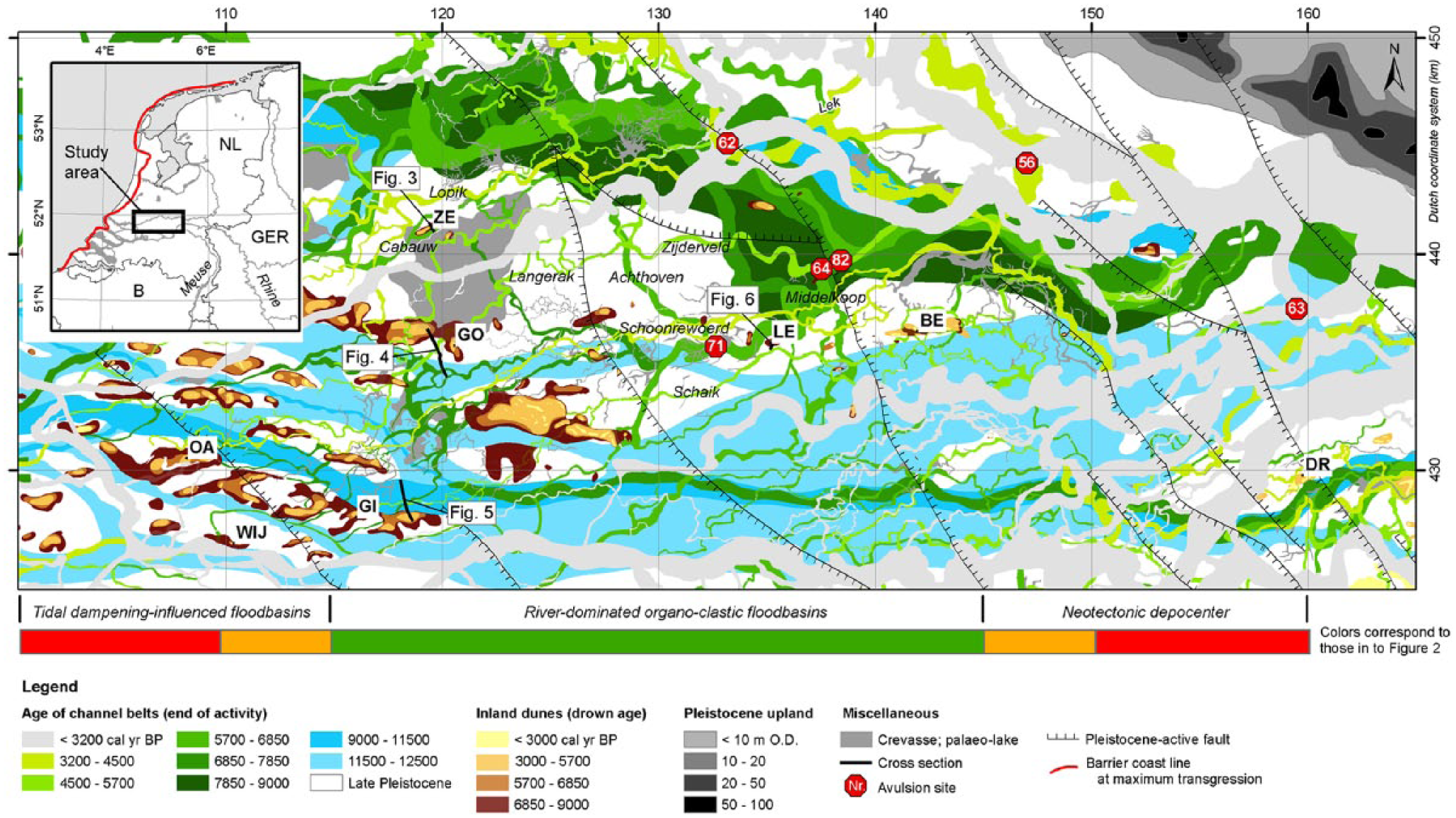
Study area in the central part of the Rhine-Meuse delta, including the locations of cross sections, avulsion sites and inland dunes. The approximate location of the barrier coastline in the inset is redrawn after Hijma and Cohen (2011) and Vos (2015).
The main objective of this study is to investigate the effects of avulsion on groundwater tables and peat-forming plant communities in floodbasins. We will discuss identified effects and their implications for Holocene and modern deltas. This will contribute to a better understanding of past, present and future delta evolution, alluvial architecture and the heterogeneity of organo-clastic Holocene sequences.
Groundwater table rise and avulsion history in the RM delta
The dominant controls on rising groundwater tables during the Holocene have been eustatic sea-level rise and regional net subsidence (combined basin tectonics and glacio-hydro isostasy). Other local factors are tides, differential subsidence, fluvial discharge and topographical and hydrological setting (Cohen, 2005). The relative importance of these local factors in the RM delta has varied in time and space. Rising sea levels and groundwater tables in the RM delta have mostly been reconstructed using radiocarbon-dated basal peat samples (e.g. Berendsen et al., 2007b; Cohen, 2005; Hijma and Cohen, 2010; Jelgersma, 1961, 1979; Törnqvist et al., 1998; Van de Plassche, 1982, 1995; Van Dijk et al., 1991; Vink et al., 2007). As in most deltas around the world (Stanley and Warne, 1994), the final stages of postglacial transgression established the modern RM delta at the beginning of the middle-Holocene. The resulting deltaic wedge is composed of intercalated tidal, estuarine and fluvial deposits, including organic beds (e.g. Berendsen and Stouthamer, 2000; Bos, 2010; Gouw and Erkens, 2007; Hijma and Cohen, 2011). The wedge is ~25-m thick in the westernmost part and thins eastward to the delta apex near the Dutch–German border (Figure 1). The base of the transgressive systems tract was largely formed between ca. 8450 and 8250 cal. yr BP during the last significant Holocene sea-level rise acceleration (~2 m/100 years), causing near-instantaneous drowning of significant areas of the former RM palaeovalley (Hijma and Cohen, 2011).
Rapid sea-level rise during the beginning of the middle-Holocene (Figure 2) resulted in coastal retrogradation and a high avulsion frequency between 8000 and 7300 cal. yr BP (Stouthamer and Berendsen, 2001). Thereafter, the rate of sea-level rise slowed significantly, tidal inlets narrowed and coastal barrier retrogradation slowed to stabilize ca. 6300–6000 cal. yr BP. Successively, widespread freshening of the back-barrier lower delta plain occurred, and peat formation was widespread for 3000 years (Gouw and Erkens, 2007; Hijma and Cohen, 2011; this stage hosts the ‘maximum flooding surface’ in sequence stratigraphic division schemes). The time period of completed transgression and widespread peat formation coincides with a relatively low avulsion frequency, which can be explained by (1) increased fixation of channels under altered overbank sedimentation conditions and (2) reduced transverse floodplain gradients, reducing the opportunity for avulsion (Stouthamer and Berendsen, 2001). Between 3200 and 1400 cal. yr BP, the avulsion frequency in the central delta increased again, and this has been attributed to the increased fine-grained sediment load of the river (Erkens et al., 2009; Stouthamer et al., 2011) that, in turn, was because of prehistoric deforestation in the German hinterland (Erkens et al., 2009; Hoffman et al., 2007).
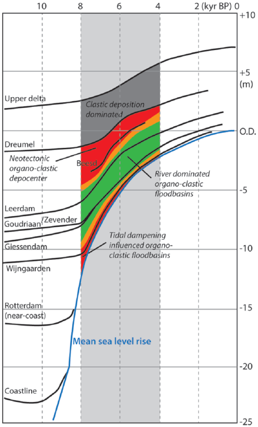
Relative groundwater table rise at a series of locations in the lower, central and upper RM delta (after Cohen, 2005; Hijma and Cohen, 2010; Van Dijk et al., 1991; Vos et al., 2015). This study focuses on the middle-Holocene time period and the river-dominated organo-clastic part of the delta (in green; X = 115 to X = 145 in Figure 1). Site selection avoided areas where floodbasin sedimentation was influenced by tidal dampening or neotectonics (in red, transition zone in orange).
Methods
Local groundwater table reconstructions using dune sites
The curves of Holocene local groundwater table rise were reconstructed from radiocarbon-dated peat samples that directly overlie the flanks of inland dunes. These age–depth plots represent relative groundwater table rise in the palaeovalley in the same manner that basal peat curves in the downstream estuarine and lagoonal parts of the delta represent relative sea-level rise, that is, including regional land subsidence as well as absolute water-level rise. Basal peat samples come from strata that directly overlie sandy aeolian sediments, minimizing compaction effects in the curves.
The basal peats sampled for these reconstructions are swamp peat and fen-edge peat (Alnus peat, that is, alder peat), which form approximately at or slightly below the annual mean groundwater table (Charman, 2002). During the middle-Holocene period, predominantly Alnus peat formed on the flanks of inland dunes, against a background of steady net rise in groundwater tables. The stratigraphic position of these Alnus peat layers confirms that drowning occurred. These layers directly overlie a palaeosol of early-Holocene age developed in the sandy substrate of Late Pleistocene and earliest Holocene age. The palaeosol indicates that groundwater level stood below the pre-transgression land surface, whereas subsequent burial of the soil by the basal peat indicates rise in the groundwater table above that surface. This implies that the dated palaeosol–peat contact reflects the timing of palaeosurface drowning at sampled depth (Jelgersma, 1961). Because of that, the indicative meaning of basal peats for reconstructing rising groundwater positions can be firmly established (Van de Plassche, 1982). Furthermore, the rising trends in age–depth plots of reconstructed groundwater rise are independently reproduced at multiple locations. This has confirmed the general robustness of the basal peat method (Vis et al., 2015) for reconstructing Holocene relative sea-level rise (e.g. Hijma and Cohen, 2010; Jelgersma, 1979; Kiden, 1995; Makaske et al., 2003; Van de Plassche, 1995; Van de Plassche et al., 2005, 2010; Vos et al., 2015) and deltaic groundwater table rise (Berendsen et al., 2007b; Cohen, 2005; Törnqvist et al., 1998; Van Dijk et al., 1991).
When the age of the base of a peat bed is radiocarbon dated, the depth–age combination gives an ‘index point’ for groundwater table rise. All basal peat samples used in this study were collected and dated during previous field studies in the RM delta (explained and referred to in the following sections and in Supplementary Material A, available online).
Age calculations
We used 16 conventional radiocarbon-dated basal peat samples from earlier studies at the inland dune sites Leerdam, Goudriaan and Giessendam (Figure 1; Supplementary Material A, available online; Berendsen and Stouthamer, 2001; Cohen et al., 2012; Van Dijk et al., 1991). In addition, we used 13 accelerator mass spectrometry (AMS) radiocarbon-dated basal peat samples obtained from the dune sites Zevender and Giessendam (Figure 1; Supplementary Material A, available online; Bos, 2010; Van de Plassche et al., 2010). Methods for preparing peat samples for dating using conventional and AMS techniques are described in Törnqvist et al. (1992, 1998).
All radiocarbon dates were calibrated using Oxcal 4.1 (Bronk Ramsey, 2001) with the IntCal13 calibration curve (Reimer et al., 2013). A vertical series of basal peat samples, collected from the flank of an inland dune, were calibrated using the Sequence deposition model (Bronk Ramsey, 2008). This model assumes that deposition occurs in a specific order, that is, age increases with depth. If two samples were obtained from the same depth, they were pooled using the function Combine (Bronk Ramsey, 2008).
Depth calculations
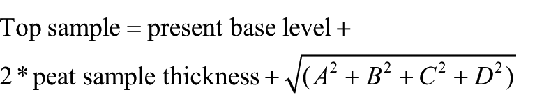
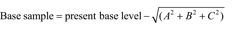
The depth of the palaeogroundwater table, relative to the Dutch Ordnance Datum (≈ present mean sea level), was derived from the current depth of the basal peat sample. Depending on the peat type, this depth should be corrected for the water depth at which the peat sample has formed. We used only index points derived from wood peat (mainly Alnus peat), as commonly occurs along the flanks of inland dunes. Wood peat forms approximately at the annual mean groundwater table. If used as a groundwater-level index point collected in a consistent vertical series, it has a commonly used uncertainty range of ±0.1 m (Hijma and Cohen, 2010; Törnqvist et al., 1998; Van de Plassche et al., 2005). In addition, height correction for compaction was applied as follows. The base of a basal peat sample is positioned at or slightly above the sandy surface of the dune, and therefore this depth will not have changed significantly since formation. The top of the sample, especially when dates are derived from relatively thick basal peat samples, may have been lowered because of compaction. We used 20 samples that are less than 5-cm thick, 4 samples that are 5- to 10-cm thick and 5 samples that are 10- to 15-cm thick (Supplementary Material A, available online). Recent studies in the central RM delta indicate peat compaction percentages of around 50% at maximum for peat at the base of the Holocene sequence (Van Asselen, 2010; Van Asselen et al., 2010). Accordingly, a factor 2 was used to acquire a compaction-corrected thickness and the original height of the peat sample. In more downstream tidal-influenced areas in the lower delta (formed in the 8000–6000 period; sites used by Berendsen et al., 2007b; Van de Plassche et al., 2010), greater compaction-correction factors for basal peat apply, because of loading by relatively thick and dense tidal estuarine deposits (Hijma and Cohen, 2011).
Vertical uncertainties in the calculated groundwater table positions arise from the following:
Measuring the surface elevation relative to fixed benchmarks of known elevation. We used an estimated error of ±0.01 m (cf. Berendsen et al., 2007b).
Measuring sample depth relative to the surface (error set at ±0.02 m cf. Berendsen et al., 2007b).
Uncertainty in water-depth calculations (±0.1 m for wood peat, see above).
Uncertainty in compaction calculations. We consider this uncertainty to be proportional to the thickness of the peat sample (factor 2 correction).
Based on these inputs, the palaeogroundwater level, including error range, was calculated (see also Supplementary Material A, available online), using standard error-propagation rules:
Basal peat data from the selected dune sites were plotted in age–depth diagrams, including error boxes, and evaluated versus a background regional rising trend to identify local fluctuations. The excess local groundwater table rise was calculated as the difference between the vertical error ranges of index points and the regional trend curve. The regional rising trend was derived from a three-dimensional (3D) geostatistical interpolation of Holocene groundwater table index points (basal peat) in the RM delta for blocks of 1 km × 1 km by 200 years (Cohen, 2005). Groundwater tables were estimated from 313 index points defined by a location (X, Y) and age (A). The interpolation consists of two parts: (1) composing a trend function that captures the general Holocene rising trends downstream and upstream in the RM delta, including a time-dependent rate of the groundwater table rise, and (2) a block-kriging interpolation of residuals with respect to the trend function, to cover subregional deviations of the general trend (Cohen, 2005). The objective of the interpolation was to yield a smoothed groundwater table rise result, which was done using a wide range and a relatively large difference between the nugget and sill in the 3D variogram (Cohen, 2005). The relative weights and distance of index points to the prediction location depend on the configuration of the index points, with a maximum distance of 42 km in east–west direction and 30 km in north–south direction. In the central middle-Holocene part of the RM delta, where the density of observations is relatively high, we estimate that observations located within a radius of ~20 km significantly contribute to the prediction of the regional groundwater level. Hence, local groundwater table fluctuations observed from age–depth plots are compared with a regional rising trend covering ~1250 km2 surrounding the studied site. Holocene groundwater-level gradients in the RM delta (apex-to-coast) are visualized at 1000-year intervals in Cohen (2005). 3D groundwater distribution maps for the same time intervals are presented in Koster et al. (2016), derived from an updated version of Cohen’s (2005) model.
Cross sections for organo-clastic avulsion cases
Cross sections were used to evaluate peat-type stratigraphy which was then used to assess impacts of groundwater table fluctuations observed in the age–depth plots on peat formation. The exact location of cross sections was selected based on (1) the proximity to dune sites where local and regional groundwater table rise was reconstructed and (2) availability of detailed lithological borehole data from past studies (e.g. Berendsen et al., 2007b; Berendsen and Stouthamer, 2000; Bos, 2010; Cohen et al., 2005; Makaske, 1998; Törnqvist et al., 1993, 1998; Törnqvist and Van Dijk, 1993; Van Dijk et al., 1991). These studies are, in part, the same studies that identified the locations of the dune sites, but also include channel-belt architectural and geomorphological studies. The age-control and lithological data have been collected by staff and students of the Department of Physical Geography at Utrecht University during the past 40 years. The boreholes were logged at 10 cm intervals for sediment texture, colour, oxidation/reduction characteristics, calcium carbonate content and other relevant properties such as the occurrence of shell fragments, concretions and sediment-layer transitions (e.g. Berendsen et al., 2007a; Berendsen and Stouthamer, 2001). For classification of peats, two basic descriptive criteria are particularly useful. First, the field description of visible plant remains allows a distinction to be made between reed peat (mainly Phragmites Australis) and wood peat (mainly Alnus; see Bos et al. (2012) for descriptive treatment of this type of data). Second, field estimates of organic-matter content based on colour and textural observations permit identification of three peat classes (org1 = high-organic, org2 = medium-organic and org3 = low-organic) and three humic clay classes (strongly humic, humic, slightly humic; see Supplementary Material B, available online; after De Bakker and Schelling, 1966). The quality of the lithological borehole descriptions differs from region to region and the type of study during which they were collected (see Berendsen et al., 2007a; Berendsen and Stouthamer, 2001; Bos et al., 2012). For this study, only high-quality borehole descriptions were used (references in Table 1).
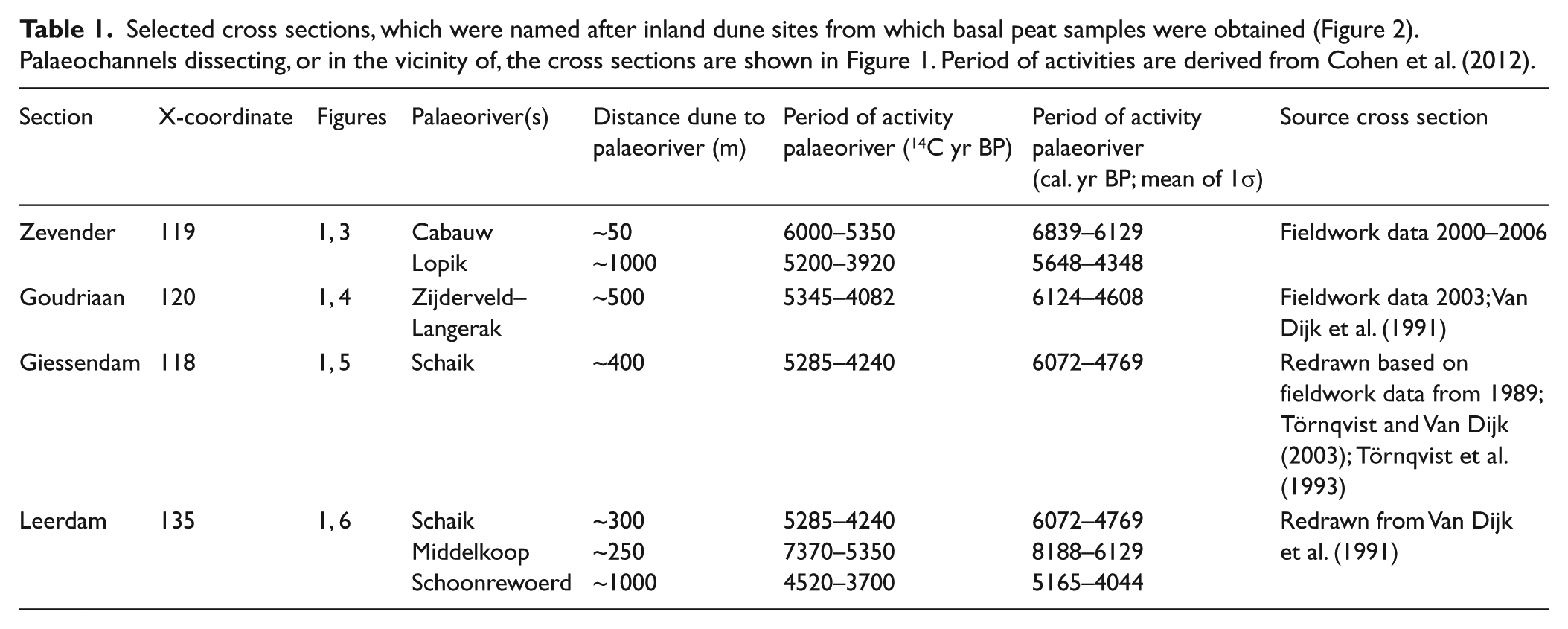
Selected cross sections, which were named after inland dune sites from which basal peat samples were obtained (Figure 2). Palaeochannels dissecting, or in the vicinity of, the cross sections are shown in Figure 1. Period of activities are derived from Cohen et al. (2012).
Specification of cross sections and avulsion events
Selected cross sections and avulsions in the central part of the RM delta are summarized in Tables 1 and 2, respectively. All sites are located inland of the limit of tidal influence in floodbasins that are 7000–4000 years old (at ~X = 115; Cohen, 2005; Van Dijk et al., 1991). Based on (1) the local groundwater age–depth plots superimposed on the background rising trend, (2) cross sections and (3) regional mapping of avulsive distributaries, we evaluated whether avulsions have affected the local groundwater table and peat formation. In particular, we examined the possible roles of floodbasin configuration and distance from the avulsion site.
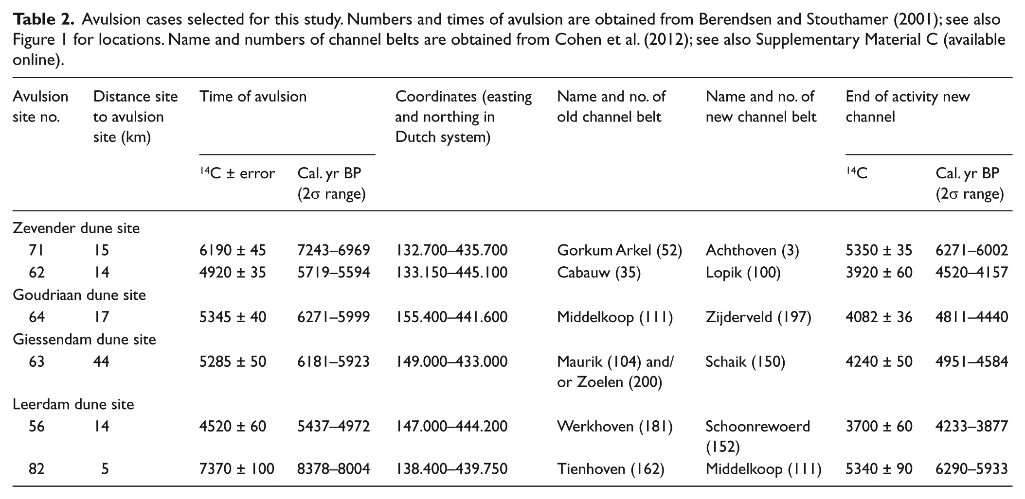
Avulsion cases selected for this study. Numbers and times of avulsion are obtained from Berendsen and Stouthamer (2001); see also Figure 1 for locations. Name and numbers of channel belts are obtained from Cohen et al. (2012); see also Supplementary Material C (available online).
Results
Zevender site
The age–depth plot of dated basal peat samples obtained from the flank of the Zevender inland dune shows an increased rate of local groundwater table rise at ca. 5800 cal. yr BP (Figure 3b). The excess groundwater table rise, compared with the regional signal, is between 0.41 and 0.97 m. The accelerated rise corresponds to the starting phase of activity of the Lopik channel, located approximately 1 km north of the Zevender dune (Tables 1 and 2; Figure 1). The avulsion site is located ~14 km from the dune site (Table 2). At that time, the relict Zevender inland dune top was a small island in the swampy floodbasin that received the Lopik channel, reaching >3 m above the surroundings. Adjacent to it, the Cabauw channel belt appeared as an alluvial ridge ~1.5 m above the floodbasin (Figure 3: compare the top of the Cabauw natural levee (coring 2002.05.101) with the level of Lopik clayey overbank deposits overlying the sandy dune surface (coring 2002.05.503)).
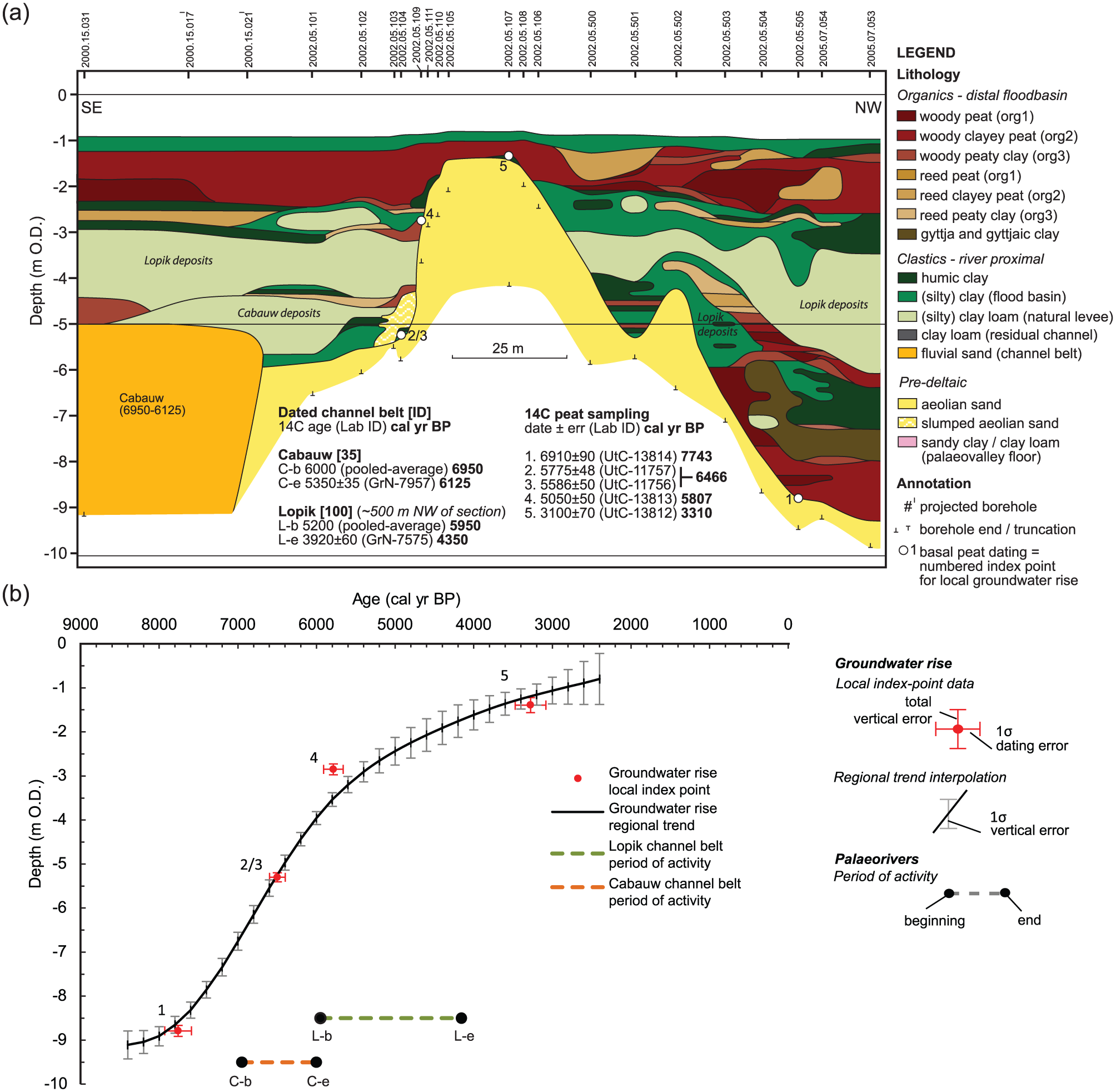
(a) Lithological cross section of the Zevender site. For location, see Figure 1. (b) An age–depth plot for local groundwater index points and regional groundwater rise for the Zevender site. Index point numbers correspond to those used in (a). See Supplementary Material C (available online) for details on the period of activity of the channel belts.
At depths below ~−4.5 m OD, the older Cabauw channel belt is found, which is the downstream continuation of the Achthoven channel belt (Figures 1 and 3a). The Cabauw channel was active from ca. 6800 cal. yr BP onwards and dissected the southern flank of the Zevender dune. During the Cabauw period of activity, wide floodbasin lakes developed in the vicinity of the dune (Bos, 2010; Cohen et al., 2012). A large (>100 km2) shallow lake environment extended both to the north and the south of the Zevender dune. The southern part of this floodbasin lake received clastics (Bos, 2010; his Schoonhoven lake), and the Cabauw channel belt emerged from the gradual progradational filling of the lake with riverine sediment. To the north of the dune, the lake was mostly filled by organics, initially predominantly gyttjas (Bos, 2010). In this part of the lake, clayey clastic sedimentation and terrestrial (wood) peat formation expanded once the Cabauw system activated. Prior to ca. 6800 cal. yr BP, wood peat was forming along the northern flank of the dune (between ~−6 and −9 m OD; Figure 3a). The organics filled the lake, shallowing and transforming open waters to fen and swampy wetland which was impacted by the Lopik channel avulsion. The main Lopik channel belt occurs approximately 1 km north of the dune, and minor distributaries (crevasse channels) occur closer by, in part, occupying residual-channel topography of the Cabauw system. The Lopik channel belt directed part of its discharge through the floodbasin surrounding the Zevender dune.
On the flanks of the Zevender dune, overbank deposition of the Cabauw and Lopik palaeorivers temporarily stopped most formation of wood peat, with only few small patches remaining (roughly between −6 and −2.5 m OD in Figure 3a). At the same time, further away from the dune and closer to the channel belts, patches of reed peat are intercalated between clastic deposits of the Cabauw and Lopik rivers. After termination of the Lopik channel at ca. 4350 cal. yr BP, clastic input decreased drastically and swamp forestation resumed. This resulted in the formation of predominantly wood peat, with some patches of reed peat (approximately between −2.4 and −1 m OD in Figure 3a).
Goudriaan site
An accelerated rise in the groundwater table is observed at ca. 5250 cal. yr BP (Figure 4b), corresponding to a local elevated groundwater table of 0.33–0.86 m. This matches the period of activity of the Zijderveld–Langerak channel belt that feeds the Goudriaan area (Table 2; Figure 1). The Zijderveld–Langerak channel originated ca. 6250 cal. yr BP following an avulsion ~17 km upstream and flowed ~500 m north of the site (Tables 1 and 2; Figure 1; Cohen et al., 2012). North and south of the Zijderveld–Langerak channel relict inland dunes appeared as islands. The site is located at the distal southern side of the large Schoonhoven lake (see above). At the time the Zijderveld–Langerak channel came into existence, the lake was filling in with clastics by the Cabauw river, but at a lower rate than the Zevender site (Bos, 2010) so that the southern part of the floodbasin was still mostly lacustrine. The older Nieuwland–Vuilendam channel, occurring at greater depth, was buried and no longer an alluvial ridge (Figure 4). Crevasse channels developed while the Zijderveld–Langerak channel belt was active (Figure 4a, borehole numbers 2003.41.011, 2003.41.29 and 2003.41.032).
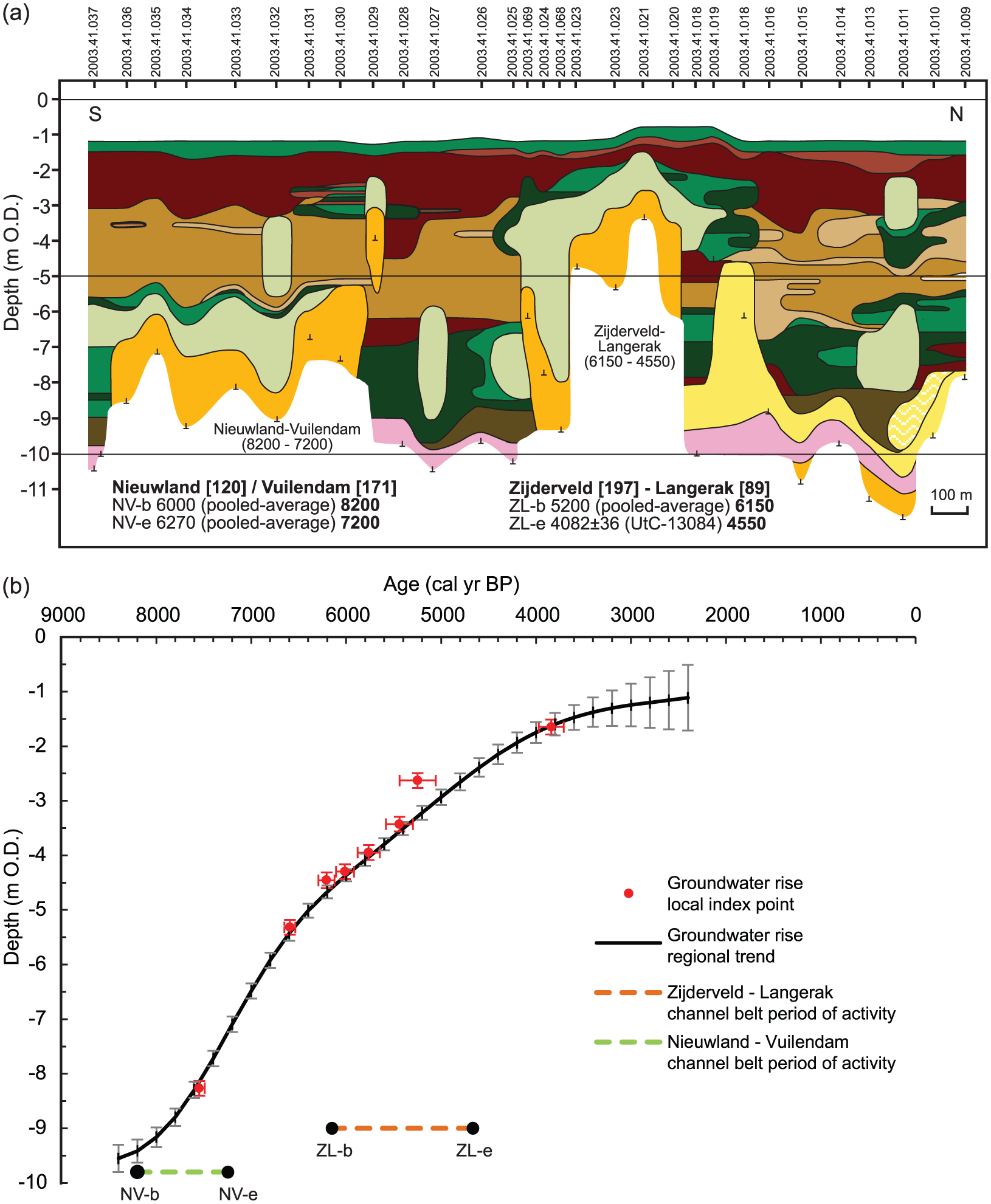
(a) Lithological cross section of the Goudriaan site. For location and legend, see Figures 1 and 3a, respectively. (b) An age–depth plot for local groundwater index points and regional groundwater rise for the Goudriaan site. For the full legend, see Figure 3b; for details on the period of activity of the channel belts, see Supplementary Material C (available online).
At ~100 m from the Zijderveld–Langerak channel belt, a 3-m-thick layer of reed peat occurs between ~−6 and −3 m OD, which extends for several hundreds of metres north- and southward (Figure 4a). At the same level, natural-levee and clastic floodbasin deposits occur closer to the palaeochannel, which was active between ca. 6100 and 4600 cal. yr BP (Figure 4a; Table 1). Below this level (<−6 m OD), overbank deposits of the older Nieuwland–Vuilendam channel belt dominate the sequence, intercalated with thin, often clayey, wood peat (on top of sandy channel-belt deposits) and reed peat (next to channel-belt deposits) layers. Above the 3-m-thick reed-peat layer, high-organic wood peat has formed after abandonment of the Zijderveld–Langerak channel (Figure 4a; Table 1).
Giessendam site
At this relatively downstream-positioned site, no significant accelerations of local groundwater table rise are observed when the Schaik channel belt was initiated (Figures 1 and 5; Table 2). The Schaik channel belt and its flanking distributaries comprise a relatively long system traversing the entire central delta from its avulsion site ~44 km upstream to the Giessendam site. Wood-peat forming wetlands dominated the immediate vicinity of this site when the Schaik channel belt was active.
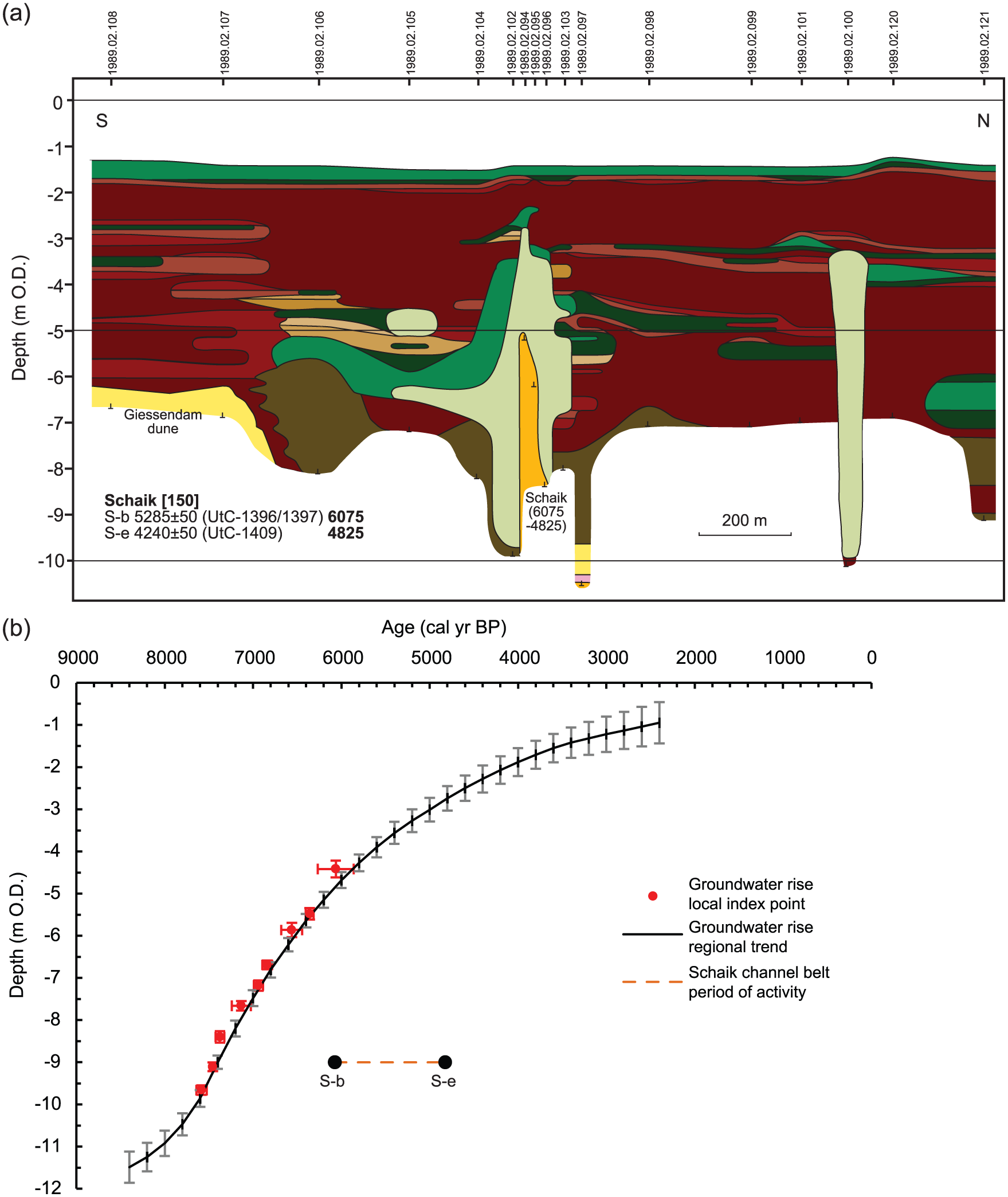
(a) Lithological cross section of the Giessendam site. For location and legend, see Figures 1 and 3a, respectively. (b) An age–depth plot for local groundwater index points and regional groundwater rise for the Giessendam site. For the full legend, see Figure 3b; for details on the period of activity of the channel belts, see Supplementary Material C (available online).
In the lowermost parts of the cross section, gyttja deposits suggest similar lithostratigraphic, biostratigraphic and chronostratigraphic interpretation as those from the nearby site Molenaarsgraaf (Van der Woude, 1981). The organo-clastic sedimentology and palynology studies indicate the presence of lakes, here originating from the early part of the middle-Holocene (8000–7000 cal. yr BP). During following periods of decelerating relative sea-level and groundwater-level rise, these lakes filled successively with gyttja, reed and swamp forest (Van der Woude, 1981). The initiation of the Schaik channel is indicated by increased clastic deposition, partly filling the nearby lake south of the palaeochannel with clay and depositing clay in the swamp forest (Figure 5a; Van der Woude, 1981). During this period, both north and south of the Schaik palaeochannel patches of mostly clayey reed peat developed within several hundreds of metres from the channel (Figure 5a). Directly next to the Schaik channel and its natural-levee deposits, predominantly wood peat formed (Figure 5a). After abandonment of the Schaik channel, regional wood-peat formation resumed.
Leerdam site
The age–depth plot for the Leerdam site is based on conventional radiocarbon dates from relatively thick samples processed in the late 1980s and early 1990s. The data from this site are thus of somewhat lower quality compared with the other sites (see section ‘Methods’). The slightly greater rise in the groundwater table observed at ca. 7500 cal. yr BP (Figure 6b) is not further discussed here. This occurred in a newly transgressed local setting before our studied time period of 7000–4000 cal. yr BP and during which minor dm-scale eustatic effects cannot be ruled out (Van de Plassche et al., 2010). In later times, no local groundwater-rise accelerations or decelerations are detected that correlate with known avulsions affecting this area. All index points from the Leerdam site are, however, positioned above the regional trend, indicating that in the vicinity of the Leerdam inland dune, the groundwater table was up to 1.11 m higher than the regional groundwater table. This may have been because of the continuous influence of middle-Holocene channels (Middelkoop, Schaik, Schoonrewoerd) that flowed towards and closely alongside this site (Table 1, Figure 1). The dune appeared as an island throughout the periods of activity of these palaeochannels. At the beginning of activity of the Schaik channel, the Middelkoop channel belt was an elevated alluvial ridge reaching a height of ~1.0 m above the floodbasin level (Figure 6a; compare top levee of the Middelkoop channel with the groundwater level related to the beginning of activity of the Schaik channel).
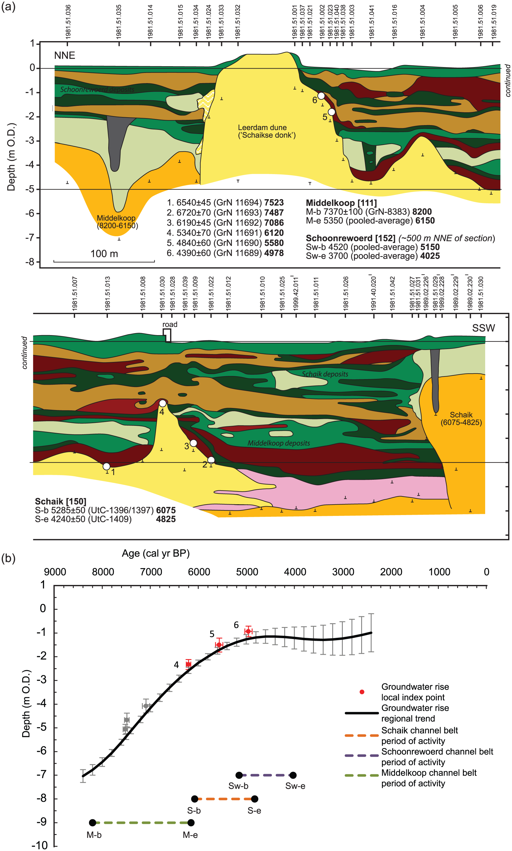
(a) Lithological cross section of the Leerdam site. For location and legend, see Figures 1 and 3a, respectively. (b) An age–depth plot for local groundwater index points and regional groundwater rise for the Leerdam site. For the full legend, see Figure 3b; for details on the period of activity of the channel belts, see Supplementary Material C (available online).
During the active period of the Schaik channel, predominantly reed peat was formed near the Leerdam dune (peat layer around −2 m OD; Figure 6a), intercalated with clastic deposits, while before and after that time mainly wood peat was formed. This is supported by borehole data used to construct a cross section 3 km downstream of the dune (Törnqvist and Van Dijk, 1993; their Figure 5). Evaluation of these data revealed that during activity of the Schaik channel, mainly reed peat was formed near the channel.
Discussion
Effect of avulsion on local groundwater table
We have documented different impacts of middle-Holocene avulsions on local groundwater table rise in floodbasins of the central RM delta. Explanations can be sought in (1) differences in the receiving environment, that is, shallow lacustrine versus terrestrial wetland floodbasin, and (2) reduction in impact with increased distance downstream from the avulsion site, for example, by the leaking away of discharge to a complex crevasse network parallel to the main channel (Törnqvist et al., 1993). The Goudriaan, Giessendam and Zevender cases during Cabauw channel-belt activity comply with the first explanation. The palaeochannel avulsions did not induce significant groundwater-level rise in the receiving floodbasins while these were occupied by lakes. Excess water supplied by the avulsed rivers entering these floodbasins is reckoned to have dissipated in the lakes, thereby impeding any effect on the local water-table height. This mechanism also explains the delayed effect of the Zijderveld–Langerak channel at the Goudriaan site: at the beginning of activity, lakes still existed in the affected floodbasin. Only when these lakes (remnants of the larger Schoonhoven lake) were filled by clastic sediments and organics could excess water supplied by the palaeoriver cause accelerated rise in the groundwater level.
The second explanation, that of distance from the avulsion site, is best illustrated by the Giessendam case. Those sites that show significant rises are located at 5–20 km downstream from the avulsion site (Figure 1; Table 2). In contrast, the Giessendam site, located at a greater distance from the avulsion site, does not show a significant rise. The more distal sites Wijngaarden and Oud-Alblas, however, do show a rise in the groundwater table between approximately 6000 and 4000 cal. yr BP (Berendsen et al., 2007b). This signal may be attributable to tidal influences which may be affected by avulsion (see section ‘Introduction’). Unravelling interacting controls on avulsion impacts in floodbasins is a topic for future research.
Our studied cases thus suggest a relationship between distance from the avulsion site and the effects on the local groundwater table. A possible explanation for this trend is the downstream-increasing dispersal of discharge carried by the avulsed river. It follows that distance from the point where the avulsed river enters the floodbasin compartment is the controlling factor, not distance from the avulsion site. Delta-plain floodbasins are bound by alluvial ridges left by earlier avulsions. Discharge dispersal, that is, by leakage from the main channel into the floodbasin, will be more significant where an avulsed channel dissects a relatively wide and elongated floodbasin than where it traverses a narrower and shorter one.
In other words, the floodbasin’s inherited configuration influences its sensitivity to hydrological impacts of avulsions. In a small floodbasin, avulsion-induced excess discharge will effectively raise the groundwater table more than in a larger floodbasin. Similarly, in floodbasins with a downstream outflow, as in the lower delta, water tables will rise less than in ‘closed’ floodplains (Dirschl, 1972). For example, when the Lopik channel belt avulsed to the Zevender dune site, this site was a relatively small enclosed area surrounded by alluvial ridges inherited by the Cabauw channel system (Figure 1). This confined setting, in addition to the differences in receiving environment discussed above, probably promoted the observed accelerated rise in the groundwater table. Also at the Leerdam site, alluvial ridges and inland dunes were island outcrops in the floodbasin (Figure 1, see also section ‘Results’), acting as barriers to floodwater dispersal (e.g. Davies-Vollum and Smith, 2008; Dirschl, 1972).
Ultimately, the impact of an avulsed river on the local groundwater table will depend on the combination of river discharge, sediment load and floodbasin configuration, besides boundary conditions that influence local hydrological conditions such as sea-level rise, land subsidence and subsurface composition (Cohen, 2005).
Effect of avulsion on peat formation
At all studied sites, reed peat increases relative to wood peat with increasing distance from the channel belt (Figures 3–6). Directly adjacent to or overlying inland dunes, channel belts and natural levees, wood peat predominates as would be expected on such higher and drier locations (e.g. Bos et al., 2012; Dirschl, 1972; Van der Woude, 1981). Further away from the channel and/or dune, the shift to reed peat is brought about by changing water regime (deepening), nutrient status (increased) and probably also pH (to less acidic). Avulsion thus affects several environmental gradients associated with vegetation and peatland evolution (e.g. Charman, 2002; Den Held et al., 1992; Dirschl, 1972; Tuittila et al., 2012).
The cross sections illustrate that formation of reed peat occurs at varying spatial and temporal scales. At the Goudriaan site, a reed-peat bed up to 3-m thick and distributed over hundreds of metres has formed during the active period of the Zijderveld–Langerak channel. At the Leerdam site, widespread and long-lived accumulation of reed peat formed two separate layers of up to 1 m thick each. At the Giessendam site, only thin patches of clayey reed peat occur. This is most likely because of the greatly dispersed and nutrient-rich discharge. Discharge of the Zijderveld–Langerak river and upstream Schaik and Schoonrewoerd rivers, at the Goudriaan and Leerdam sites, respectively, was probably less dispersed, and their flanking wetlands were regularly (re-)inundated with sediment- and nutrient-rich floodwaters. This promoted reed and clayey peat formation at enhanced aggradation rates. At the Zevender site, clastic deposition from the Cabauw and Lopik palaeorivers dominated over peat formation, resulting in thin and relatively less extensive layers of reed peat intercalated with clastic deposits. These central-delta case studies show the extent and duration of reed-peat formation to largely reflect avulsion-distributed discharge and sediment loads.
The repeatedly observed shifts in botanical composition are related to changes in admixed siliciclastics: the avulsion-associated reed peats are more clayey than the wood peats below and above. This suggests that in the initial stages of the development of new channels, their fine sediment is trapped over a relatively wide zone across the adjacent floodbasin. At the end of the avulsion-belt initial stage (cf. Smith et al., 1998; Stouthamer, 2001), after which a matured channel-levee system continues to function, the pattern of distal sedimentation changes. A larger proportion of clastic overbank deposits is then trapped close to the channel, while further away from the channel floodbasin peats become higher organic and less nutrient-rich in status. This channel-belt maturation process may take centuries, which implies that avulsion-triggered changes in hydrological conditions and peat type in floodbasins need not be long-lived, as also appears from the cross sections reconstructed in this study.
Especially at the Zevender and Goudriaan sites, the age–depth plots indicate that floodbasins invaded by avulsed river and crevasse channels show a stepped rise in the groundwater table that is accompanied by shifts to formation of reed peat. However, sites without a prominent accelerated rise in the groundwater table (e.g. the Giessendam site) may also show increased production of reed peat in the floodbasins, albeit more clay-rich. Thus, whereas the impact of avulsion on peat formation is seen at all sites owing to changes in sediment and water delivery, nutrients and pH, avulsed channels do not always raise local groundwater tables.
Linkage with transgression and high-stand delta development stages
We observe environmental changes in the organo-sedimentary functioning of floodbasins in the central part of the Holocene RM delta from ca. 6000 cal. yr BP onwards and relate this to decelerating and stabilizing sea-level rise. Before that time, rates of sea-level rise and, concomitantly, rates of inland groundwater table rise, were relatively high. In the last stage of postglacial transgression (Hijma and Cohen, 2011), wide delta plains with extensive floodbasins and large lakes were established in the study area (Van der Woude, 1981; Bos, 2010; this study). Between 8000 and 6000 cal. yr BP, while sea-level rise gradually decelerated, these lakes accumulated mixed clastic and organic fills (Bos, 2010). From 6000 cal. yr onwards, when the coastal barrier system stabilized, the lakes of the central delta, like the tidal systems downstream, had mostly developed infilled and extensive peat wetlands. Over the same middle-Holocene period, several generations of channel belts were formed and subsequently abandoned by avulsions (Berendsen and Stouthamer, 2000; Stouthamer and Berendsen, 2000). Under the reduced rates of sea-level rise during the past 6000 years, abandoned channel belts have remained as alluvial ridges in the delta plain, and repeated avulsions have gradually increased the degree of floodbasin compartmentalization. In the successively smaller floodbasins, our findings show that succeeding avulsions have had more pronounced effects on the local groundwater table and peat formation than in the large open settings during final transgression earlier in the middle-Holocene.
The deceleration of eustatic sea-level rise is a common control on global delta development (Cohen and Hijma, 2014; Stanley and Warne, 1994). The mechanism of transition from large open floodbasins to smaller compartmented floodbasins, identified here, probably occurs in other large deltas containing extensive organo-clastic sub-environments.
Our research shows that palaeogeographical evolutionary changes – affecting the dimensions and connectedness properties of floodbasins – strongly determine how the interactions work out, and in what ways they are architecturally and lithologically recorded. We propose that future research further explores the magnitude and duration of avulsion impacts in different Holocene deltaic settings in relation to, for example, the influence of floodbasin configuration, as well as other factors that may influence local groundwater tables and peat formation.
A better understanding of relationships between avulsions, local groundwater tables and peat formation will improve assessments of the environmental impacts of natural avulsions and ‘managed’ avulsions in modern densely populated deltas. Current examples include ecological engineering measures for restoring Mississippi delta swamps (Costanza et al., 2006; Day et al., 2007), and assessing the boundary conditions for ecological variation in modern ‘natural’ deltas (e.g. Pantanal, Brazil: Makaske et al., 2012). The risk of permanent status changes in land inundation and ecology, for example, would affect livelihood conditions in these areas, forcing changes in land use and food and water supply, and altering the risk of certain diseases (e.g. malaria and other mosquito-transferred infections). Because avulsions may change the local mean groundwater table, and hence environmental conditions, their likelihoods of occurrence should be considered in sustainable delta management strategies.
Conclusion
In the organo-clastic part of the RM delta, middle-Holocene case studies show that avulsion may enforce temporary acceleration of groundwater table rise in affected floodbasins. The impact of discharge and sediment diversion is especially pronounced in small and confined floodbasins that were initiated in the central RM delta since ca. 6000 years ago (at the beginning of the high-stand stage). In the preceding transgressive times, central and downstream delta floodbasins were larger, less enclosed and were occupied partly by lakes. In that situation, avulsions had much less impact on groundwater table variations, and downstream (tidal) control was stronger. In the central delta, groundwater effects of avulsions are more direct and apparent than in the downstream regions where tidal controls interact with avulsion effects so as to prohibit simple reconstruction. In wide and elongated organo-clastic floodbasins, downstream dispersal of river discharge yields reduced discharges at individual sites, resulting in smaller avulsion-induced groundwater rise.
In addition to its effects on groundwater tables, avulsion also affects peat formation, because of the changes in average water depth, sediment delivery, nutrient status and acidity. Such avulsion-induced changes promoted shifts from relatively high-organic wood peat to more clayey reed peat in the vicinity of newly avulsed channel belts. The extent and duration of this shift are largely controlled by distance from the active river, local discharge and sediment load.
A better understanding of relationships between avulsions and their environmental impacts in invaded floodbasins is vital for interpreting facies and buildup history of Holocene floodbasin sequences, and for managing the organo-clastic regions within often densely populated deltas worldwide.
Footnotes
Acknowledgements
The authors thank the reviewers and editor for their constructive comments and editorial suggestions, which substantially improved this article. They also thank their partners within the Department of Physical Geography, Utrecht University, for discussions.
Funding
This research was supported by Utrecht University, The Netherlands, and is part of the research focus area Future Deltas (https://www.uu.nl/futuredeltas) and the Delta Evolution research programme of the Department of Physical Geography (![]() ), Utrecht University.
), Utrecht University.
References
Supplementary Material
Please find the following supplemental material available below.
For Open Access articles published under a Creative Commons License, all supplemental material carries the same license as the article it is associated with.
For non-Open Access articles published, all supplemental material carries a non-exclusive license, and permission requests for re-use of supplemental material or any part of supplemental material shall be sent directly to the copyright owner as specified in the copyright notice associated with the article.