
Abstract
We present 17 cosmogenic 10Be ages of glacial deposits in Coire an Lochain (Cairngorm Mountains), which demonstrate that glacial and nival deposits cover a longer timescale than previously recognised. Five ages provide the first evidence of a late-Holocene glacier in the British Isles. A previously unidentified moraine ridge was deposited after c. 2.8 kyr and defines a small slab-like glacier with an equilibrium line altitude (ELA) at c. 1047 m. The late-Holocene glacier was characterised by rapid firnification and a dominance of sliding, enabling the glacier to construct moraine ridges in a relatively short period. Isotopic inheritance means that the glacier may have existed as recently as the ‘Little Ice Age’ (LIA) of the 17th or 18th century
Keywords
Introduction
Scotland’s last glaciers are generally accepted to have vanished at the close of the Younger Dryas Stadial (YDS), around 11.5 kyr (Golledge et al., 2008). Geomorphological evidence of Holocene glaciers has proved elusive, though a favourable climate for cirque glaciation in the ‘Little Ice Age’ (LIA, c.
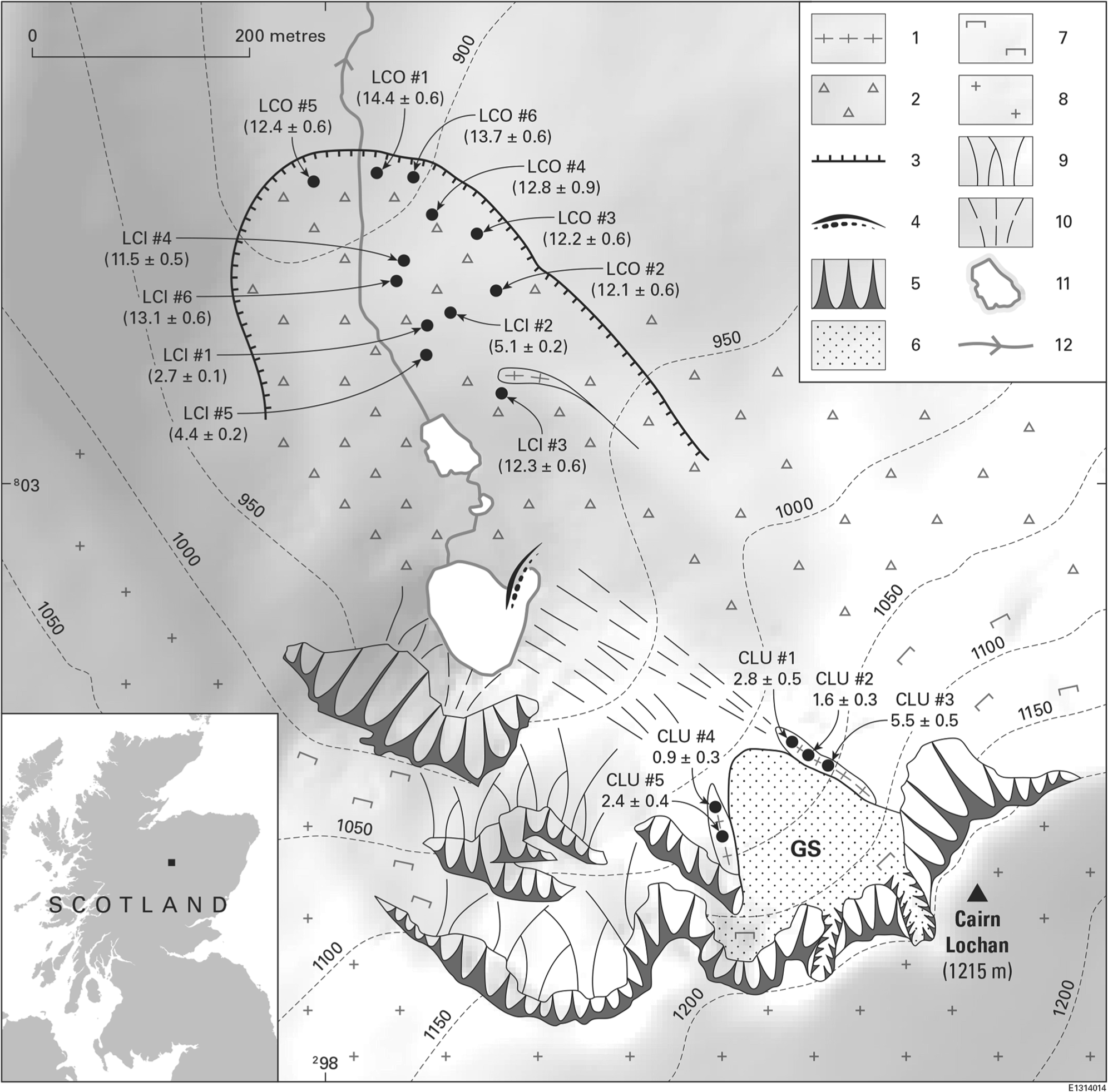
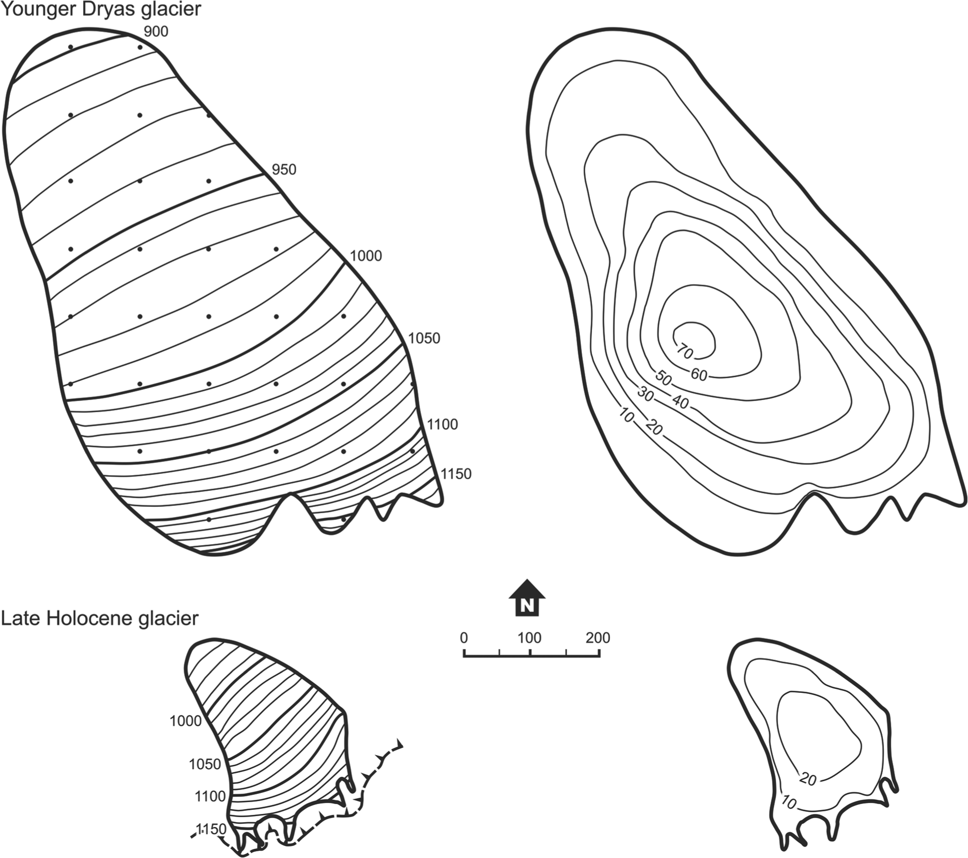
Geomorphology of Coire an Lochain showing the locations, sample numbers and exposure ages of 10Be samples and the former glacier extents in the cirque. Key: GS = Great Slab; 1 = moraine ridge crest; 2 = boulder sheet; 3 = margin of YDS till sheet; 4 = avalanche-impact pit; 5 = rock faces; 6 = rock slab; 7 = rock outcrops; 8 = frost-shattered mountain-top debris; 9 = scree slopes; 10 = polygenetic debris cones and avalanche aprons; 11 = lake and 12 = permanent stream. Contour lines are in metres above sea level. Easting and northing reference points refer to UK National Grid.
Geomorphological evidence
Several glacial and nival landforms are identified within the cirque (Figure 1). The cirque-floor boulder sheet was deposited as supraglacial melt-out till during retreat from the YDS maximum extent, and was ascribed a YDS age by Sissons (1979). The maximum glacier extent is clearly defined by its distal edge, although lack of a distinct terminal moraine ridge suggests that the maximal extent was short-lived. A lateral moraine can be traced up the eastern glacier margin, constraining reconstruction of the glacier ablation zone.
The cirque backwall comprises a debris slope leading up to the Great Slab, a stepped, plucked, low-angled (c. 25°–30°) granite slab which merges upslope with the vertical 100-m-high headwall (Figures 2 and 3a). The junction of slab and cliff is free of rockfall talus, in contrast to ledges elsewhere on the cirque walls. The rock scenery of the upper cirque is ‘clean’ and has been interpreted as the source of a pre-YDS rock slope failure by Ballantyne (2013). Bordering most of the east edge of the slab, and the lower west edge, are small but prominent steep-sided debris ridges, of which the eastern ridge extends for >100 m obliquely downslope (Figures 1 and 3b). The western ridge terminates abruptly upslope at a rock wall. The two ridges do not meet at the base of the Great Slab, but form an opposing pair, and are interpreted as ice-marginal moraines.
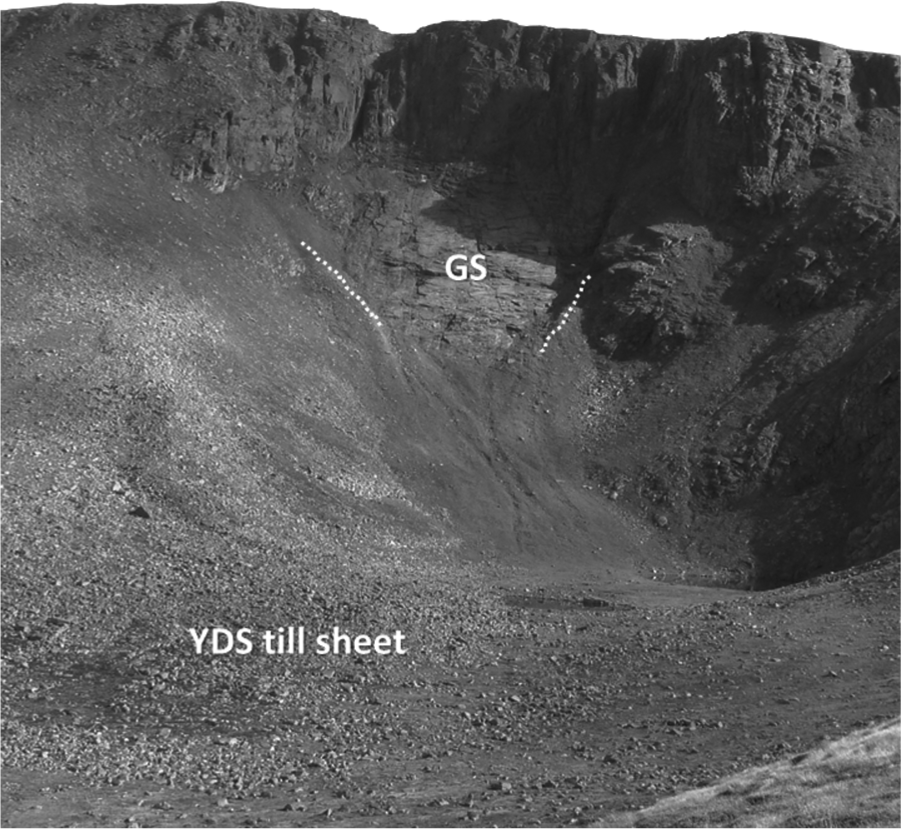
View from the north into Coire an Lochain. Moraine crests in the upper cirque are indicated by white dotted lines. Below the Great Slab, an apron of snow-avalanche and debris-flow debris extends downslope to the main cirque lake (just visible to the right). The bouldery till sheet of YDS is indicated.
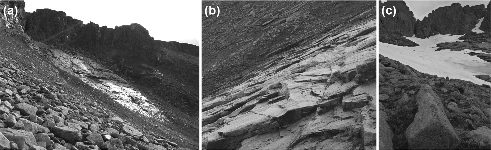
Details of the late-Holocene glacial landforms in the upper part of Coire an Lochain. (a) Looking south-west to the prominent right-lateral moraine on the near side of the Great Slab. Note the absence of debris accumulation between the slab and the headwall in (b) view from the left to the right-lateral moraine, across the plucked steps of the Great Slab. The right-lateral moraine is the steep grassy boulder ridge at the far side of the slab – (c) a boulder, embedded in the late-Holocene right-lateral moraine, sampled for 10Be dating.
The Great Slab (Figure 3b) is a source of full-depth snow avalanches in heavy-snow years, which are continuing to trim the lower ends and proximal slopes of the moraine ridges to deposit elongated splays of avalanche-reworked debris downslope (Figure 1). The avalanche debris apron extends to the lake (Figure 2), whose small eastern bay is interpreted as an avalanche-impact pit. Snow avalanches from the south-western cirque headwall onto lake ice have been observed to generate floods downstream through the till sheet (Bullivant, personal communication, 2011).
A glacial origin of the ridges is interpreted on the basis of their form and location. They contain matrix-supported angular granite clasts, up to boulder size, in a matrix of coarse sand and grit (Figure 3c). Boulder surfaces are pink in colour and markedly less edge-rounded compared with the grey weathered boulders on nearby slopes and till sheets (Figure 3a). Moraine boulders are smaller than in the cirque-floor till sheets, and soil cover is thin with no horizon development. The ridges are oriented at a highly oblique angle to the headwall above, do not extend up to it and extend too far downslope for gravitational transport of debris across a firn field to have been the main debris source (cf. Ballantyne and Benn, 1994). For these reasons, a protalus origin for the ridges is discounted. No clast shape analysis has been conducted because a significant contribution to construction of the ridges may have come from reworking of pre-existing debris, which could have incorporated material with different transport histories. Thus, clast shape data are unlikely to provide diagnostic evidence of genesis.
Field and laboratory methods
The location and relatively unweathered clasts of the Great Slab moraine indicates a significantly younger age than the cirque-floor till. Exposure-age dating was used (1) to test the presumed YDS age for the latter, which was initially sampled with a view to investigating whether the whole deposit was of a single age, and (2) to investigate whether the Great Slab moraine represents evidence of a small Holocene glacier in the upper cirque. Rock samples were collected from large embedded boulders protruding from the moraine (Figure 3c), to avoid more recent debris deposited on the ridge surface by rockfall or snow avalanches. Samples CLU#1 to CLU#3 were from the longer right-lateral moraine, and CLU#4 and CLU#5 from the left-lateral moraine. Six samples were collected from each of the inner and outer parts of the cirque-floor boulder till, labelled LCI#1 to LCI#6 and LCO#1 to LCO#6, respectively. All were from the upper surfaces of boulders large enough to protrude above the surrounding boulder layer to minimise snow shielding. Sample locations are shown in Figure 1.
Samples were processed at the Cosmogenic Isotope Analysis Facility (CIAF) in the Scottish Universities Environmental Research Centre (SUERC). Rock samples were crushed and ground, and quartz was separated from other minerals by mechanical (magnetic) and chemical (hexafluorosilicic acid treatment and hydrofluoric acid leaching) procedures. 10Be extraction and target preparation followed procedures modified from Kohl and Nishiizumi (1992) and Child et al. (2000). The 10Be/9Be ratios were measured using the 5 MV accelerator mass spectrometer (AMS) at SUERC (Xu et al., 2010). The Be ratios were converted to nuclide concentration in quartz. Details of sample locations and analytical data are given in Table 1. We provide two sets of exposure ages (Table 2), both calculated using the Cronus-Earth online calculator v. 2.2 (http://hess.ess.washington.edu/). However, the first set is calculated using a global production rate (4.39 ± 0.37 atoms/g/yr; Lm scaling) obtained from age-constrained calibration measurements (Balco et al., 2008). The use of these widespread calibrations points leads to an increase of the scaling uncertainties.
Sample locations and analytical details for the late-Holocene moraine (CLU) and the YDS till sheet (LCI and LCO).
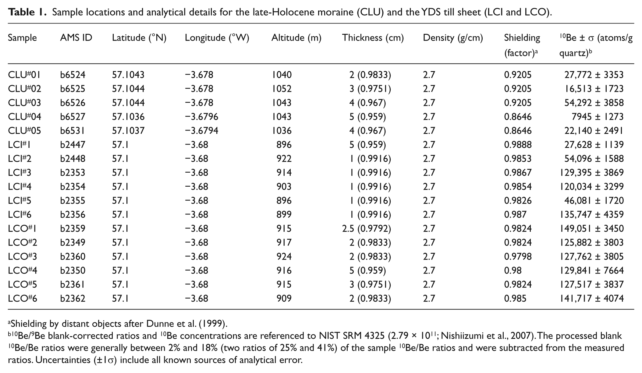
Shielding by distant objects after Dunne et al. (1999).
10Be/9Be blank-corrected ratios and 10Be concentrations are referenced to NIST SRM 4325 (2.79 × 10¹¹; Nishiizumi et al., 2007). The processed blank 10Be/Be ratios were generally between 2% and 18% (two ratios of 25% and 41%) of the sample 10Be/Be ratios and were subtracted from the measured ratios. Uncertainties (±1σ) include all known sources of analytical error.
Exposure ages and associated analytical uncertainties based on global and local production rates.
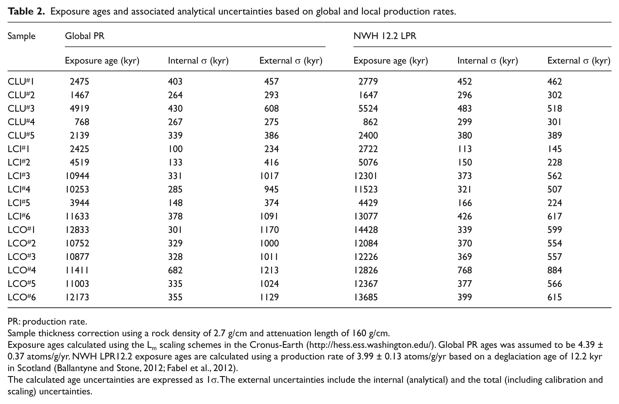
PR: production rate.
Sample thickness correction using a rock density of 2.7 g/cm and attenuation length of 160 g/cm.
Exposure ages calculated using the Lm scaling schemes in the Cronus-Earth (http://hess.ess.washington.edu/). Global PR ages was assumed to be 4.39 ± 0.37 atoms/g/yr. NWH LPR12.2 exposure ages are calculated using a production rate of 3.99 ± 0.13 atoms/g/yr based on a deglaciation age of 12.2 kyr in Scotland (Ballantyne and Stone, 2012; Fabel et al., 2012).
The calculated age uncertainties are expressed as 1σ. The external uncertainties include the internal (analytical) and the total (including calibration and scaling) uncertainties.
New local calibration sites indicate that the global production rate used in the Cronus-Earth calculator is too high (e.g. Balco et al., 2009; Fenton et al., 2011). The second set of exposure ages was calibrated using a locally derived 10Be production rate (NWH LPR12.2; Ballantyne and Stone, 2012; Fabel et al., 2012), which is lower than the global production rate and has lower uncertainties related to scaling (sea-level high-latitude production rate 3.99 ± 0.13 atoms g/yr; Lm scaling). Thus, the 10Be ages calculated using the LPR (Table 2) are older and more precise than 10Be ages calculated with the global production rate. Although the NWH LPR12.2 is not independently constrained, it corresponds closely to the Loch Lomond production rate (LLPR) of 3.92 ± 0.18 atoms/g/yr (Lm scaling; Fabel et al., 2012). The LLPR is based on the 10Be concentration from boulders on the Loch Lomond terminal moraine and is independently constrained by radiocarbon dating (MacLeod et al., 2011).
Results
Chronology
The whole cirque-floor till sheet yields ages consistent with deposition in the YDS (Table 2). For the inner area of till (samples LCI#1 to LCI#6), the LPR calibration gives three ages of between 11.5 ± 0.5 and 13.1 ± 0.6 kyr (mean = 12.3 kyr). Three samples yield mid-Holocene ages of between 2.7 and 5.1 kyr. These boulders are interpreted to have been overturned after deposition either by snow avalanching from the western slopes of the cirque, or by avalanche-generated flood waves from the lake (freshly avalanche-disturbed boulders were observed nearby after the 2009–2010 winter). Four of the six samples from the outer till range in age from 12.1 to 12.8 kyr; the other two (LCO#1: 14.4 kyr and LCO#6: 13.7 kyr) may be inherited ages from older foreland debris incorporated into the YDS till close to the maximum of the advance. The mean age of samples LCI3, LCI4, LCI6, and LCO2 to LCO5 is 12.3 kyr – several centuries older than the dated YDS maximum at the type site in the south-western Scottish Highlands (MacLeod et al., 2011).
Five 10Be ages from the Great Slab moraine (Table 2) range from 0.9 ± 0.3 years (CLU#4) to 5.5 ± 0.5 years (CLU#3) using the LPR calibration: four are younger than 2.8 ± 0.5 kyr. The wide spread of ages is interpreted as an effect of isotopic inheritance. Low rockfall rates in the Holocene (Ballantyne and Harris, 1994) would logically be associated with variable concentrations of cosmogenic beryllium in cliff faces, whose exposed surfaces will comprise a mosaic of small facets of very different exposure ages. Rock falls can therefore be expected to contain varying concentrations of cosmogenic beryllium which are inherited by the moraine ridges following a short glacial transport path. It follows that 10Be ages should be interpreted as maximum ages for the moraines, and that the youngest boulder sampled provides the closest chronological control on moraine age. By this reasoning, the maximum moraine age lies between c.
Glacier reconstruction and climatic implications
Glacier morphology was reconstructed at a scale of 1:6250 and contoured at a 10 m interval, from which surface slopes and hypsometric curves were calculated and former equilibrium lines estimated using an accumulation area ratio of 0.6 (Figure 4). Isopach maps were constructed by subtraction of present-day relief from the former glacier surface topography by grid sampling of the reconstructed glacier surfaces. Glaciological reconstructions followed the method of Carr et al. (2010), based on the best-fit regressions of empirical relations from contemporary glaciers. An independent estimate of summer (June–August) temperature was used to calculate total accumulation and winter balance at the equilibrium line altitude (ELA) of each glacier. Accumulation is used to estimate ablation gradients, which are in turn applied to the hypsometric curves to estimate mass loss per altitudinal band of each ablation zone (mean annual ablation multiplied by the area between contour lines). In equilibrium mass balance, total mass loss from an ablation zone equates to the balance discharge through the ELA, which divided by cross-sectional area gives the balance velocity. The creep velocity equation of Paterson (1994) is then applied to calculate the average rate of ice flow due to deformation, using flow law parameters of n = 3 (exponent) and 5.3 × 10⁻¹⁵/s/kPan (constant). The latter value is for temperate ice so a lower value may be appropriate for the YDS glacier, in which case the present results will overestimate creep velocity. Average sliding velocities through the ELA are estimated as the difference between the balance and creep velocities.
Reconstructions of the Younger Dryas (top) and late-Holocene (bottom) glaciers in Coire an Lochain, to the same scale. Surface topography is shown on the left, and ice thickness on the right, each with a 10 m contour interval.
The mean summer ELA temperature for the late-Holocene glacier was taken as the present (1981–2000) temperature minus 1.5°C (see Harrison et al., forthcoming). Present-day temperature was based on Aviemore weather data recorded at 228 m altitude, adjusted to the ELA using an empirical lapse rate of 0.007°C/m calculated from the temperature difference between Aviemore and Cairngorm summit (1245 m, 2.5 km to the east-northeast). The mean summer temperature for the YDS glacier ELA was derived from a contemporary chironimid-based mean July temperature of 6.8°C (from Brooks et al., 2012) from Abernethy Forest, 230 m a.s.l. and 15 km to the north. The mean July temperature was adjusted to a June–August average using their present-day ratio, and then to the ELA using the same lapse rate. The YDS July temperature at 230 m altitude was 7.3°C cooler than the present day.
The results of the glaciological and climatic reconstructions are shown in Table 3. The startling statistic is the three-fold decrease in precipitation and accumulation values in the YDS, associated with ablation-season temperatures close to freezing and very low turnover. In contrast, the late-Holocene glacier required high winter accumulation to sustain the glacier through summers averaging 4.1°C across the ablation season, and 6.9°C for July. Similar average shear stresses between the two glaciers mask the contrast between a thin, steep and more dynamic late-Holocene glacier in which 85% of motion was through basal sliding on a smooth, impermeable rock slab, and a thicker, colder and less dynamic YDS glacier, which existed in a cold continental environment (Table 3). One commonality between the glaciers is that both depended strongly on enhanced accumulation by blown snow from the surrounding plateau (Harrison et al., forthcoming; Sissons, 1979). This offset the aridity of the YDS and the warmth of the late Holocene to allow glaciers to form and survive in each period.
Reconstructed climatic and glaciological parameters for the Coire an Lochain glaciers, following the method of Carr et al. (2010).
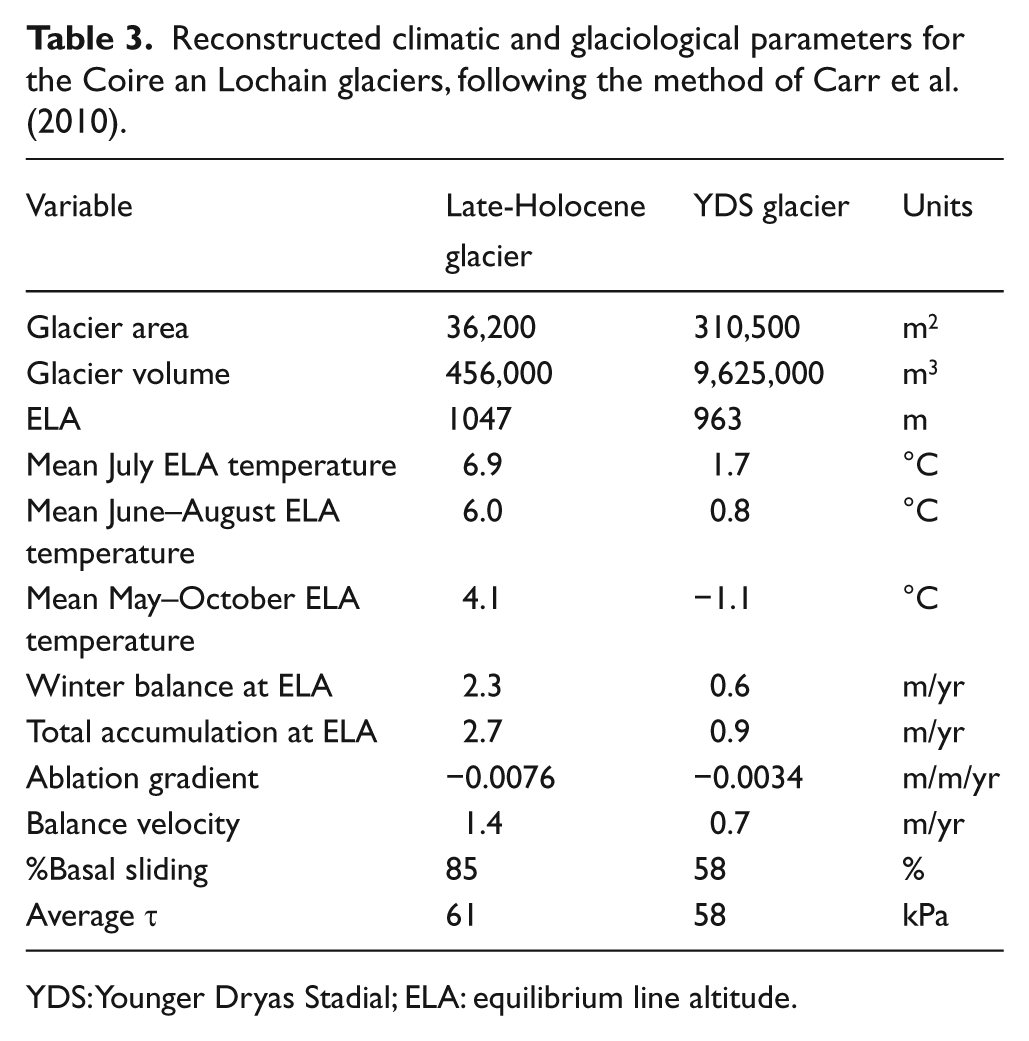
YDS: Younger Dryas Stadial; ELA: equilibrium line altitude.
In Carr et al.’s (2010) method, sliding velocity is pragmatically a residual value after other parameters have been calculated, and is ultimately dependent on the best-fit summer temperature-accumulation regression. Ohmura et al.’s (1992) relation of June–August temperature and approximate annual precipitation (winter accumulation plus summer precipitation at ELA) includes the standard deviations around the best-fit curve, allowing a range of possible precipitation scenarios to be modelled. Taking the June–August ELA temperature of 6.0°C for the late-Holocene glacier (Table 3), Ohmura et al.’s relation also yields an annual precipitation value of c. 2.70 m/yr but with a ±1σ range of 2.25–3.25 m/yr. At the upper end of this range, mass turnover in the Coire an Lochain glacier could therefore have been 20% greater, with a higher sliding velocity to maintain equilibrium.
Reconstruction of the late-Holocene glacier gives results that are climatically and glaciologically credible. However, the question remains as to whether a small accumulation zone of 27,500 m2 combined with a high accumulation rate was able to hold firn for a sufficiently long period to form glacier ice above the ELA. This question is addressed by comparing an estimated mean residence time of snow and ice in the accumulation zone with the time taken for attainment of the firn–ice transition (a density of 0.85 g/cm3: Paterson, 1994). For a calculated accumulation-zone volume of 413,000 m3 and a balance discharge through the ELA of 4150 m3/yr, the mean residence time would have been c. 100 years. In temperate glacial environments where saturation of the snowpack occurs, the firn–ice transition can be reached in as little as 5–7 years (Paterson, 1994). Glacier ice therefore would have formed quickly above the ELA.
However, a residence time of c. 100 years also requires the glacier to have survived for longer than this in order to construct moraines at lower altitude, and this may pose a problem given the marginal conditions for glaciation in the late Holocene. The possibility exists that the glacier may not be accurately represented by Carr et al.’s model due to its thin, steep form and smooth impermeable bed: conditions of high shear stress combined with low normal stress promote effective basal pressure variations and bed separation (Benn and Evans, 2010). A significantly higher mass turnover may have been possible if sliding velocity was faster, sustained by greater local wind-blown enhancement of accumulation than the above calculations have estimated. By back-calculating from balance velocity to the mean specific net accumulation required to maintain equilibrium, a balance velocity of 5 m/yr would require net accumulation of only 0.67 m/yr with a 27 years accumulation-zone residence time. Corresponding values for a balance velocity of 10 m/yr are 1.34 m/yr and 14 years. These scenarios seem more plausible, and would have allowed the glacier to construct moraines within a lifespan of much less than 100 years, although ablation would also have to be greater than calculated by the Carr et al. method.
Discussion: A LIA glaciation in the Cairngorm Mountains?
The orbitally driven decline in Holocene temperatures since the Climatic Optimum (Mayewski et al., 2004; Wanner et al., 2008, 2011) led to the earliest neoglacial glacier advances in high-latitude and high-altitude mountains in Europe and Scandinavia, where the terrain was high enough for the glaciation threshold to be crossed at earlier stages of the mid-Holocene cooling. Subsequent cooling led to a later onset of neoglacial advances in lower ranges. The Scottish Highlands were only approaching the glaciation threshold late in the Holocene. Our results demonstrate that a small glacier existed in the upper cirque of Coire an Lochain since c. 2.8 kyr, after snow-avalanche disturbance of YDS boulders since the mid-Holocene. This finding is the first firm evidence of Holocene glacier formation in the British Isles. The glacioclimatic reconstruction shows that the ELA lay closer, in altitudinal terms, to the YDS glacier than a simple temperature driver would allow. This emphasises both the importance of enhanced precipitation for allowing glacier ice to form (Harrison et al., forthcoming), and the aridity of YDS winters in the Cairngorm Mountains.
A question of great interest is whether the glacier existed during the period of LIA glacierisation (sensu Matthews and Briffa, 2005) after
A significant question is whether the long, snowy winters of the late 17th and 18th centuries occurred frequently enough to generate and sustain glacier ice for a sufficient period to form moraine ridges. Several summaries of historical climate (Dawson, 2009; Kington, 2010; Lamb, 1995) concur that the late 17th and 18th centuries experienced the most sustained ‘glacier-friendly’ climates, and several periods when climate approached glaciation are noted by Lamb (1995) and Kington (2010). The central England temperature series (Lamb, 1995) places the greatest post-Mediaeval cool temperatures within this period. We suggest here that the period
The glaciological reconstruction of the late-Holocene glacier creates a picture of a thin, steep, sliding glacier existing close to the limit of climatic viability, facilitated by enhanced snow accumulation, rapid transformation to glacier ice, and short ice residence time. Thus, construction of small ice-marginal moraines would have been aided by a rapid supply of debris to the ablation zone margin. The location of the Holocene glacier is unusual to the extent that we suspect there would have been very few, if any, similar topoclimatic niches in the British mountains where contemporary late-Holocene glaciers could have formed (cf. Harrison et al., forthcoming). The glacier existed partly because the Great Slab supported an accumulation zone on a relatively low-angle surface above 1050 m altitude. The upper cirque is narrowly enclosed by vertical faces, providing effective shading for such a small glacier, and accumulation enhancement by the extensive plateau above is very effective, even today. Only such a combination of geomorphological factors could allow marginal glaciation in recent millennia of a warm Atlantic Ocean and dominantly westerly cyclonic airflow. Conversely, altitudes of the main cirque floors in the Cairngorm Mountains appear to have been just too low to allow ice to survive for long enough to construct moraine ridges, and reconnaissance of several cirques has produced evidence of pronival deposition rather than Holocene moraines.
In conclusion, this study has demonstrated the former presence of a glacier ice in the British Isles in the late Holocene. It seems probable that a glacier existed in Coire an Lochain in the LIA. However, few other sites in the Cairngorm Mountains are likely to have correlative moraines due to stringent topoclimatic criteria that would have been needed to be met. Glacioclimatic reconstructions highlight the extremes of glaciological environment represented by the Younger Dryas cirque glacier and the late-Holocene niche glacier. The irony is that the elusive landform evidence for recent glacial activity was discovered in one of the most visible locations in the massif.
Footnotes
Acknowledgements
Cosmogenic nuclide dating was supported by the Natural Environmental Research Council CIAF SUERC allocations 9095.1010 and 9011.0405. The support of the British Geological Survey is acknowledged. Field assistance was provided by Iain Forteath and Scott Tipple. We thank Stephan Harrison (University of Exeter) and Nic Bullivant (Cairngorm Mountain) for helpful discussions on different aspects of this research, and Simon Carr (QMUL) and an anonymous referee for their constructive comments on an earlier version of this paper.
Funding
The research received no specific grant from any funding agency in the public, commercial, or not-for-profit sector.