
Abstract
In his accounts of Montmartre and Marseille, Nicholas Hewitt shows how places on margins and frontiers channel flows of different sorts running across city, nation and world. In doing so, they open up suggestive perspectives on the nature of French territory, how it is conceived, and how it can be imagined. In particular, they foreground the productive tension of the marginal place as edge and opening, and interrogate the bounded and regulated space implied by the geometrical trope of the French ‘hexagon’. What emerges instead is a curiously liquid sense of French space-in-time as shifting, shimmering and mercurial, caught up in and contributing to the ebb and flow of global circulation. This article explores how movement, flow and liquidity have featured in recent explorations of French territory and topography, drawing on work by Jean Rolin, Agnès Varda and the photography project France(s) territoire liquide, whose title spells out its assumption about the nature of contemporary French space. At the same time, the article situates those accounts in relation to conceptions of French territory which informed the work of post-war spatial planners, whose substantial material and infrastructural legacies reflected their own sense of territory as flux, flow and liquid force.
Fluid dynamics
How do we understand France and French territory? Where might we go looking to grasp its distinctive qualities, textures, forms and functions? What figures and images do we have to describe it? Put another way, what constitutes France's territorial imaginary, the ways in which French space is conceived, perceived, thought and talked about? One of its most persistent structuring principles remains the opposition cast in spatial terms between centre and periphery, whose various manifestations (Paris and the provinces, city and suburbs, metropolitan and ‘overseas’ France) are an enduring consequence of the Jacobin reflex of centralization.
That structuring tension is held within the geometric figure of the French ‘hexagon’. The now ubiquitous discursive trope gained particular traction during the 1960s as post-imperial France reimagined its territorial (and therefore national) identity and pursued a vigorous programme of civilizational advancement through spatial planning and modernization (aménagement du territoire). Contained within it is an idea of France precisely as a contained or bounded space. From the happy geographical accident provided by the outline of the mainland frontiers could be abstracted a visual image whose geometric form at once asserted the nation's legacy as a birthplace of scientific reasoning, and enabled a politico-administrative sense of French space as a clearly demarcated and defined territorial entity – a theatre of intervention to be managed, improved, regulated, policed and otherwise governed.
A consequence (or irony) of such clear-cut and centripetal imaginings of the national territory is the extent to which marginal locations become important for getting to grips with French territory and understanding the dynamics at play within it. The forces shaping territory, nation, culture and identity often seem to be most visibly at work, most energetic or most vital at what appear to be marginal or peripheral locations; in other words, locations whose function and significance are determined by their relationship to a locus of power or agency assumed to lie elsewhere. This is one of the many insights to be gleaned from the work of Nicholas Hewitt.
In his writing on France, Hewitt was drawn to locations that exude a strong sense of place but are in some way marginal or eccentric places; or perhaps better, places whose strength of character derives specifically from their eccentricity or their marginal location. Hewitt's accounts of ||Montmartre (1996, 2017) and Marseille (2019) make manifest how places on margins, frontiers or thresholds become hubs or nodal points for lines and flows of different sorts running across city, nation and world. In doing so, they open up suggestive perspectives on the nature of French territory, how it is constituted and conceived, and how it might alternatively be imagined. In particular, they foreground the productive tension of the marginal place as edge and opening, fissure and fistula, and invite us to interrogate the bounded and regulated space assumed by the geometrical trope of the French hexagon.
Both Montmartre and Marseille are frontier locations, one in relation to the capital city and the other in relation to the national territory. As such, they have an eccentric position within a larger spatial configuration; but they are also gateways or thresholds because of that. They function as junction points for lines of various sorts: metro lines, shipping lines, lines of flight. They are points of arrival and departure, transition or orientation towards other places. As threshold locations, they are places that see the convergence, congregation and circulation of people and things, and where the conditions emerge for openness, indeterminacy and unpredictability as a result.
The creative energies that accumulated in and around Montmartre during the nineteenth century, argues Hewitt, did so in large part because of its location on the edge of the specific customs regime that demarcated central Paris and was defined physically by the Mur des Fermiers Généraux, built in 1784. ‘In the beginning was the Mur’, he notes, ‘probably one of the single most significant factors in the cultural development of Paris’ (1996: 31). The regime meant that customs tariffs were payable on food, drink and other goods destined for the city, and led to the proliferation of ginguettes and other places of leisure and entertainment on the provincial side of the barrier. Marseille, meanwhile, geared into the trading flows and migratory movements around the Mediterranean, and close by the mouth of a transcontinental river, has long seen itself as a frontier post liminal not just to the French territory, but to the European sub-continent as a whole: ‘a Mediterranean city-state at the centre of a pan-Mediterranean network’ (Hewitt, 2019: 8). In an observation with which Hewitt would undoubtedly concur, Stephen Barber suggests that Marseille is where ‘the homogeneous façade of Europe is irreparably fissured’ (2001: 34).
As Walter Benjamin well understood, the energies of marginal and threshold locations, with their possibilities and indeterminacies, are as much psychical and libidinal as they are economic. For Benjamin, one of the great attractions of the nineteenth-century Parisian arcades lay in how, as they wormed their way through the city, they folded entrances, gateways, moments of transition, traversal movements and opportunities for the unexpected into its fabric. Yet if they did so, it was in ways that were not always tangible, but might be signalled only by a pause, a hesitation, or a hover at the entrance. ‘No stone step serves to mark them. But this marking is accomplished by the expectant posture of the handful of people. Tightly measured paces reflect the fact, altogether unknowingly, that a decision lies ahead’ (Benjamin, 1999: 89). Margins and thresholds take shape as paradoxical places where movement, energy and dynamism are particularly concentrated even as they are overlooked as ordinary or unremarkable, or in some other way relegated to secondary significance, somewhere merely to pass through or move beyond.
Paying attention to the dynamics of marginal locations also opens up a more complicated sense of territory-in-movement and space-in-time, one occluded by the structurally stable opposition between centre and periphery or the geometric a-historicity implied by the figure of the hexagon (even if that figure, as I explore elsewhere – see Welch, 2023 – in fact comes loaded with all sorts of post-colonial and post-imperial ballast). Doing so brings into focus the shifting pressures at work on the national territory, how they course through marginal locations, and how as a result, the margins and frontiers of the territory (which might be at its geographic margins, but not necessarily) work to apply centrifugal force to the national territory.
Meanwhile, as the writer Jean-Christophe Bailly observes (2011: 166–167), those centrifugal pressures pull against an opposite force of inertia constituted administratively and politically to maintain a state of interior cohesion, and asserted rhetorically through naming the government ministry in charge of managing, policing and maintaining that cohesion explicitly as the ministry of the Interior. Contemporary France takes shape as a country in a constant struggle to hold the centre against a range of forces and pressures, where the consistency implied by the notion of an ‘interior’ exists more in the realm of wish and imagination, and in fact proves to be something more mercurial, shifting and uncertain.
At the same time, one of the striking things about France's territorial imaginary is the state's own preoccupation with territory in/as movement, not least as a sign and driver of economic growth, national prosperity and civilizational advance. Perhaps its most noticeable expression is the aspiration towards fluidity as an ideal of circulation on the nation's road network, one whose importance is underscored when it can be announced (circulation: fluide) on the electronic signs of the Boulevard Périphérique and other urban expressways around the country. But the stakes and consequences of that concern with fluidity emerge in other ways as well, for example when Agnès Varda films trucks cruising along the motorway in Les Glaneurs et la glaneuse (2000), her documentary about gleaners and other people who survive on the margins, making what use they can of the leftovers from the system sustained and symbolised by the trucks on the move.
It emerges too when a writer like Jean Rolin – one of the most persistent investigators of marginal space in contemporary France – turns our attention to the unremarkable or out-of-the-way infrastructural forms which engender that movement (industrial plants, port zones, motorway flyovers) as well as friches, terrains vagues and other sorts of space in transition. Through his scouting of edgeland locations, Rolin unpicks the role of such places in the contemporary world, their distinctive qualities, and how they function as niches for life on the margins. Arising from these scenes, moments and observations is a shimmering sense of French space-in-time, imbricated in and contributing to the ebb and flow of global circulation in a way that exemplifies the condition of ‘liquid modernity’ being theorized by Zygmunt Bauman (2000) around the time Varda's eye was caught by the endless stream of trucks moving goods and commodities across France (Figure 1).

Liquid modernity: trucks on the move in Agnès Varda's Les Glaneurs et la glaneuse (2000).
Inspired by Hewitt's sensitivity to the nature of marginal dynamics, my aim in the remainder of this essay is to explore how movement, flow and fluidity have featured in some recent accounts of French territory and topography, not least through gravitation towards rivers, river basins and other physical manifestations of flow in the landscape. I draw in particular on texts by Jean Rolin, always alert to the material and sensorial qualities of space, how it is transformed through human intervention, and what its forms can reveal about the forces shaping the world. I also explore work in the collaborative photography project, France(s) territoire liquide, begun in 2011 and directed by the British curator Paul Wombell. The project's title makes clear its working assumption about the nature of French space, one informed explicitly by Bauman's understanding of the contemporary era as a matter of movement and circulation, but also of the inequalities and uncertainties (social, political and financial) which derive from the fact that its main driver and beneficiary is the increasingly deregulated and unfettered flow of capital. 1
The investigation of marginal locations and marginal dynamics teases out how the dominant forms of space in contemporary France, space oriented towards movement and flow, coexist with and produce other forms of being in space and time. Also part of the story, though, are the conceptions of French territory that informed the work of post-war aménagement, whose substantial material and infrastructural legacies within the space of the nation – legacies frequently encountered in contemporary French culture – reflected the planners’ own sense of territory as flux, flow and liquid force.
A Sunday afternoon in Gennevilliers
In Le Pont de Bezons (2020), Jean Rolin's narrator relates his discontinuous and apparently haphazard investigation of a stretch of the river Seine between Melun to the south of Paris and Mantes to the north during 2019. Its focal point (though not quite its fulcrum) is the eponymous bridge of the title, which crosses the Seine downstream of the capital at Bezons, a suburban town situated alongside the river and within one of the vast, looping meanders it describes on its way to Rouen and the sea. Quite why the bridge at Bezons is given centre stage in the text and the project is unclear (as is usually the case in Rolin's texts). There is the narrator's quixotic desire to see dawn break over it, inspired by an aphoristic statement of dubious provenance that serves as the text's opening sentence: ‘heureux celui qui a vu le jour se lever sur le pont de Bezons’ (Rolin, 2020: 9). More prosaically, its centrality seems to derive from it being the northern terminus of the T2 tramway originating at the Porte de Versailles, one of the first of a new generation of tramways which the RATP began developing in the 1990s to facilitate transversal movement across the Parisian suburbs. The journey is one the narrator takes on a regular basis, he tells us, and serves as one of the main points of entry into the area under investigation.
Other, darker associations and resonances may also be in play, most notably the bridge's association with the infamous night of 17 October 1961. It was one of several locations near the Seine where Algerian protestors were killed by the French security forces in the aftermath of their march in protest against a curfew and their bodies disposed of in the river (House and MacMaster, 2006: 295). As we shall see later, the text's insistence on making visible how marginal spaces are home to marginalized people suggests that a quiet political memory might be at work in the text. Overlaying that sinister and occluded past is the everyday ordinariness of the bridge and the town from which it takes its name. For the narrator also has in mind the remark by Louis-Ferdinand Céline, perhaps the town's most famous resident: ‘Chanter Bezons, voici l’épreuve!’ (Rolin, 2020: 9). Snagged by Céline's elliptical phrase, Bezons becomes a shorthand for the archetypal peripheral location and its (lack of) qualities: somewhere that is unremarkable, undistinguished or largely functional; that is without significance, charm or distinction; somewhere, we might say, that represents a sort of degree zero of place. Yet if Rolin's narrator is drawn to explore the hinterland of Paris as it unfolds along the banks of the Seine upstream and downstream of the bridge, it is undoubtedly because of the complexity lurking in space that is overlooked or seemingly unremarkable, and what it can tell us about the world, as becomes clear in a scene early on in the text.
One Sunday in February, on the inaugural afternoon of his project, Rolin's narrator pays a visit to the port of Gennevilliers, the largest inland port in France a few kilometres up the Seine from Bezons. He spends time walking the access roads and observing the layout and composition of the space. While at first, he appreciates the calm of the port on a Sunday afternoon, ‘du fait du retrait dominical’ (2020: 13), the narrator becomes increasingly disconcerted by its stillness and quiet. His unease stems in particular, he realizes, specifically from the fact that nothing is moving: ‘à la longue le silence et l’immobilité, sur de telles distances, de tout ce qui m’entourait, et dont on sentait bien que la pente naturelle était de se mouvoir et faire du bruit, ce silence et cette immobilité se mirent à me peser’ (2020: 14).
Gennevilliers on a Sunday acquires the character of a photographic negative in relation to its dominant mode of being. The absence of noise and movement reveals them to be the port's defining qualities. It appears as a place geared towards sustaining and enhancing productive circulation, and where the energies of motion are inherent in its forms, functions and organization. Its kinetic agency is captured neatly in the narrator's use of verbal forms (‘se mouvoir et faire du bruit’) to describe its natural disposition. As an industrial location, the port is a location precisely of industry, the most celebrated and fetishized of capitalist activities in terms both of the generation of surplus value through commodity production and the morally sanctioned human effort that drives it.
The role of infrastructure in vectoring movement, noise and other forms of energy becomes apparent once again when the narrator approaches a spot near the centre of the port. Here, the ‘silence dominical de la zone portuaire’ is broken by the ‘rumeur, incessante’ of the A15 motorway as one of its elevated sections traverses the port on a sequence of concrete pillars, before bridging the Seine and heading north-west (2020: 15). The constant hum generated by the traffic on the motorway is also a reminder of how infrastructural spaces make their presence felt in the world by producing a total sensorial environment, one that impinges on sound, vision and bodily sensation. For if the port's expression of energy as noise and movement is notable by its absence on a Sunday, so too are the related sensorial and physical impingements – ‘le bruit, la poussière, les claques engendrées par le déplacement d’air au passage en trombe de poids lourds’ (2020: 14) – which a walker would endure on a weekday. Those impingements would in any case underline that walking is a mode of circulation ill-suited to the demands and tempo of such installations.
Ill-suited, perhaps, but nonetheless (or indeed, because of that) valuable heuristically as a way of grasping the singularities, qualities and significance of edgeland places. In drawing our attention to the juxtaposition of port, river and road in the middle of the port zone, the narrator also draws out how forms of infrastructure congregate at key points in the landscape. At one level, their convergence derives from topographical practicalities or technical decisions in relation to the efficient organization and use of space. Thus it made entire sense for the A15, built in the 1970s as part of the national effort of modernization through spatial planning, to be directed through Gennevilliers and ensure the port's effective integration into the national and European road network. But as nodal points of flow and exchange, such configurations also take shape in the landscape as expressions of a more fundamental human urge to circulate and the psychical stakes in doing so.
Their symbolic significance as threshold locations, unobtrusive yet profound, is mined by Béatrix von Conta in ‘Flux’, her contribution to France(s) territoire liquide (Conta, 2014). Von Conta displays a psycho-geographical sensitivity akin to that of Rolin's narrator as she homes in on points where roads cross rivers, to explore what she calls ‘ces espaces complexes et hybrides qui se forment autour des ponts enjambant les cours d’eau’ (2014: 95). As Von Conta observes, rivers themselves are complex physical entities which produce a similarly complex psychical response in the humans who encounter and live with them. They are at once link and separation, boundary and gateway, opportunity and obstacle: ‘fil réel et symbolique à la fois, la rivière traverse le paysage, mais elle est également traversée. De liaison fluviale elle devient séparation, oppose ses bords, sépare communes et paysages’ (2014: 95). In the long history of spatial development, the accelerating pace of human activity, and economic activity in particular, means that they come to be perceived primarily as boundaries or obstacles, ‘exigeant la construction des ponts, passerelles et autres passages à gué’ (2014: 95).
Yet the technical and economic imperative to solve the problem of river crossing also expresses a more elusive, perhaps more basic and more powerful human response to the world: ‘les ponts incarnent depuis toujours le désir et la nécessité pour l’homme de passer de l’autre côté, tout en employant pour y parvenir les dernières avancées technologiques. Plus haut, plus loin, plus léger. Jusqu’au plus profond du paysage’ (2014: 95). ‘Flux’ begins with images of the port of Marseille, where ferries, refrigerated trailers and lines of cars awaiting export on the quay remind us of its role as a conduit and territorial interface with the rest of the world. At the same time, Von Conta's wide-angled, elevated shots across the port enable us to grasp the architectonics of port space, and how a combination of installations (port basins, quays, jetties, seawalls) is deployed in order to bring productive order to bear on the water and enable the country's integration into global flows of circulation and exchange. The series then turns inland to consider different scales of intervention and spatial organization around rivers in the south of France. Some are barely noticeable, like the drainpipe carrying a stream beneath a road. Major rivers like the Rhône, where engineering is required both to span the river and to manage and channel its flow, demand more complex and sophisticated arrangements.
Just as Rolin's narrator opens up defamiliarizing perspectives for the reader by nosing out obscure vantage points, so too Von Conta positions her camera obliquely, off to one side, to show the structures that do the hidden work of bridging, and thereby capture something of the determination with which humans reshape and impose themselves on their surroundings. Her image of one of the Rhône's bypass canals at Montélimar, for example, shows not the body of water itself but the layering of drainage ponds, channels and other structures installed by its banks. The sense of geometric order latent in the series of horizontals intersecting with the regular incline of the canal bank is reinforced by the span of the road bridge emerging confidently from the trees uppermost in the frame. Like the other images in the series, and in a way that recalls Varda's attention to trucks on the move in Les Glaneurs et la glaneuse, a lorry is caught as it passes over the bridge, reminding us of the incessant imperative of movement and flow that has produced these spatial formations (Figure 2).
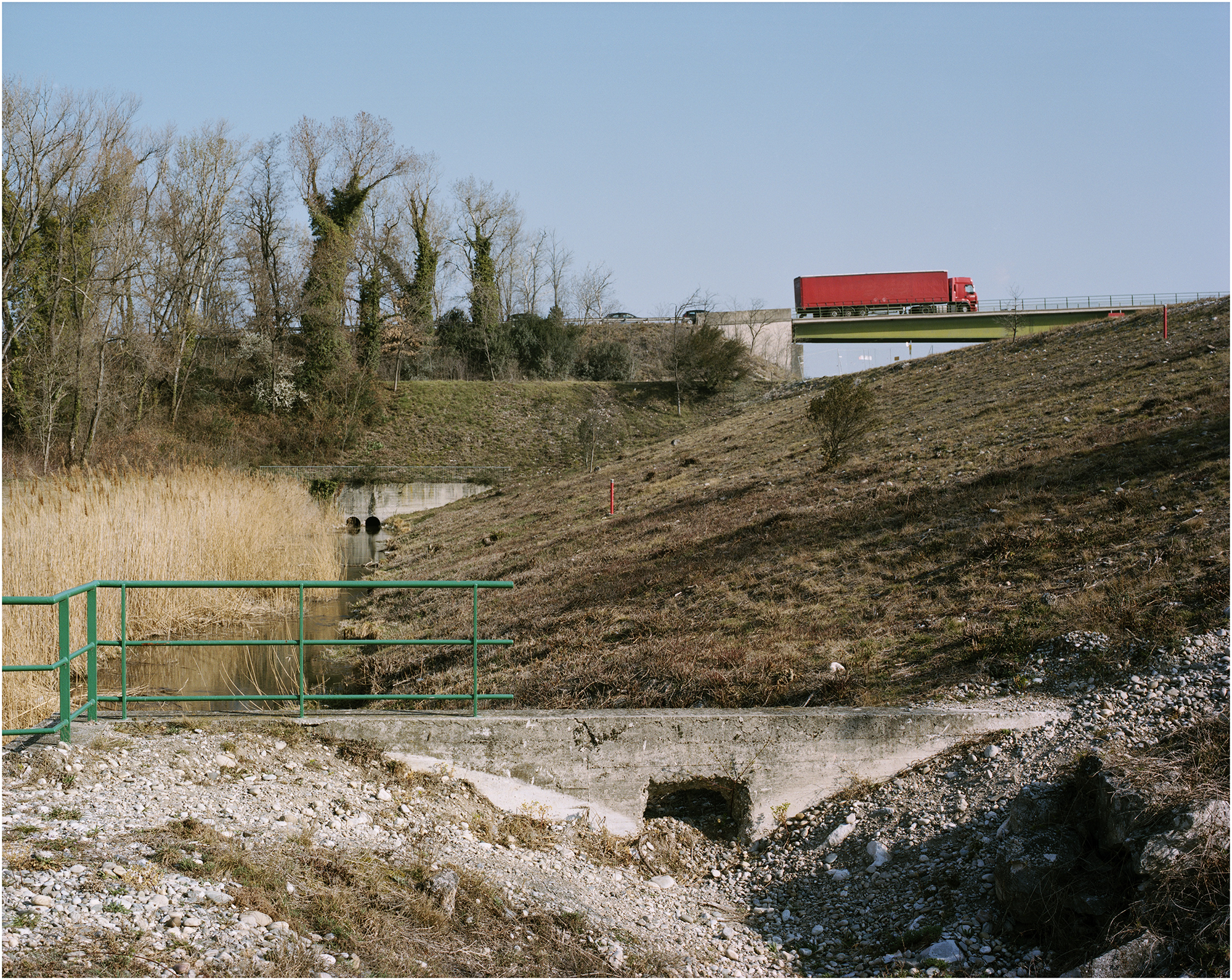
Béatrix von Conta, Pont sur le canal de dérivation de Montélimar (Rhône), Drôme 2012. Reproduced by kind permission of the photographer, courtesy of Galerie Le Réverbère, Lyon.
Between them, Rolin and Von Conta crystallize the structuring role of rivers, waterways and seaboards in French territory, and the extent to which waterways are woven into the territorial fabric as a means of sustaining the global commodity flows on which the national economy depends. Ari J. Blatt puts it nicely when he suggests that Von Conta's images of bridging bring home ‘how globalization works on an everyday scale’ (2019: 205). In exploring the extent to which humans work and negotiate with rivers, Rolin and Von Conta also capture the uneasiness of that relationship, which resides in the river's fundamental ambiguity as both link and separation. The strategic function of river crossings in a system of flow and communication also makes them points of vulnerability in times of crisis or conflict. It is not for nothing that in Les Événements, Rolin's novel from 2015 about a France in the near future riven by civil conflict, much of the narrative revolves around the feasibility of river crossing, how they gain strategic significance as locations where movement can be controlled and regulated, and how quickly they can reassert their presence as obstacles in the landscape. And as Joshua Armstrong discusses (2019: 172–174), the narrator's journey south, following roads winding along the valley of the Allier towards Port-de-Bouc on the Mediterranean coast, from where he plans to escape the territory, reveals how the physical geography of river basins determines human movement around the country.
What we might term the hydrographic approach of Von Conta and Rolin – one that writes the geography of river basins and waterways into our understanding of French territory – is not about proposing a more bucolic or nostalgic sense of a rural or pastoral France placed in opposition to the manufactured landscapes of modernization. Rather, it is a case of mapping how the physical landscapes of rivers and river basins have been co-opted into the making of French territory, and have emerged as locations whose hybridity, to use Von Conta's term – a curious fusion of human will and natural substance – captures the distinct forms and qualities of modernized French space. What they also help us to understand is how a hydrographic sense of France has permeated the ways in which French territory has been conceived and shaped and how, as a result, the qualities of uncertainty, indeterminacy and unpredictability that come with rivers, coastlines and other liminal forms are embedded and lurk within it.
French hydrographies
In Le Dépaysement, his own investigation of the relationship between France's physical geography and its territorial imaginary, Jean-Christophe Bailly reminds us of the longer history of hydrographic conceptions of French national territory. In particular, it was through an emphasis on topography, but also the relationship between topography, territory and national identity, that the discipline of geography, pioneered by Paul Vidal de La Blache, took shape in Third Republic France as both a legitimate form of academic enquiry and a means through which the nation could envision itself.
Among its most tangible manifestations were the maps of metropolitan France that began to appear in the classrooms of the nation. The most prominent, notes Bailly (drawing on his own childhood memories) was ‘celle, simple, du relief et des principaux fleuves de l’Hexagone, verte, jaune et brune, avec la Corse ajoutée dans un cartouche en bas à droite’ (2011: 168). The ‘simplicity’ of the relief map, in foregrounding the country's river basins and other physical characteristics, belied the fact that it was doing ideological as well as educational work – or more accurately, perhaps, was doing one through the other. The map's visual rendering of what Bailly calls the ‘données physiques du territoire’ (2011: 168), framed by the natural frontiers of mountain, river and sea, asserted a similarly natural and self-evident relationship between coherent physical unity and national identity that could hang on a permanent basis before the country's apprentice citizens. 2
The locations scouted by Rolin and Von Conta reveal the persistence and importance of hydrographic conceptions of French territory and how fluvial geographies have been deployed more or less visibly in the development of French territory. In 1973, the CERFI research group (Centre d’études, de recherches et de formation institutionnelles), founded by Félix Guattari, published a special issue of its journal Recherches on équipements collectifs and other forms of infrastructure, investigating them as expressions of state power but also instruments of territorial production and societal organization. Those questions were in sharp focus at a time when French space was undergoing profound transformation as the Gaullist and post-Gaullist state pursued its post-war project of modernization and civilizational advance through aménagement du territoire. In their chapter on territoriality, the group noted how rivers are dynamos whose natural force civilizations have long worked to harness and transform into productive energy, ‘énergie utile’, that can in turn drive the creation and consolidation of wealth, power and territory (Chatelet et al., 1973: 71–72). One of the most eye-catching things about the Gaullist planners’ approach to spatial development was how that ancient civilizational instinct about rivers resurfaced, most notably in their mobilization of the Seine river basin as an engine of growth.
Co-ordinated by Paul Delouvrier and published in 1965, the Schéma directeur d’aménagement et d’urbanisme de la région de Paris was oriented around the north and south banks of the Seine as ‘axes préférentiels d’urbanisation et de transport’ (DGRP, 1965: 111). Its scope of operations covered a distance of some 90 km between the two extremities of Melun to the south west and Mantes to the north west. Development of the valley downstream would connect Paris with Rouen, Le Havre and the Atlantic beyond, creating a ‘ligne de force géographique et économique à l’échelle du bassin parisien, et, plus largement, du territoire national’ (DGRP, 1965: 76). The energies of that ‘ligne de force’ would be marshalled by infrastructural improvement (road, rail, river) and by the creation of a series of new towns along the structuring axes, one of which would be Melun-Sénart (another planned for the vicinity of Mantes failed to materialize). Meanwhile, on the south coast, close to the mouth of the Rhône, the DATAR (Délégation à l’aménagement du territoire et à l’action régionale), which had been set up in 1963, was tasked with developing the Étang-de-Berre west of Marseille as a petro-chemical complex in an attempt – not wholly successful, as Hewitt notes (2019: 5) – to strengthen Marseille's economic and industrial position in the Mediterranean basin.
By the time Rolin came to undertake his ‘reconnaissances aléatoires’ (2020: 10) along the banks of the Seine between Melun and Mantes, the idea of the Seine valley as a growth corridor had reappeared as part of the ‘Consultation internationale sur l’avenir de la métropole parisienne’ launched by Nicolas Sarkozy in 2007, during the first year of his presidency. One of the ten projects in that consultation, by Agence Grumbach et Associés, was predicated on the creation of a single metropolitan area, the ‘Seine Métropole’, out of Paris, Rouen and Le Havre. Noting that the germ of the idea was present in Delouvrier's Schéma directeur, but that it had failed to make progress in reality, Antoine Grumbach argued that connecting Paris more effectively to its maritime gateway at Le Havre was essential in order for the capital to ‘se donner les moyens de maîtriser la puissance des flux commerciaux’ and secure its position as one of the great trading cities in the era of globalization (Lenne, 2008: 128). 3 The most tangible manifestation of that aim to date came in June 2021, when the ports of Paris (with Gennevilliers as its key site), Rouen and Le Havre merged to form Haropa Port, described on the group's website as ‘le Grand port fluvio-maritime de l’axe Seine’. 4
To a striking degree, then, French space is conceived and imagined in fluvial terms. If river basins are co-opted as structuring axes of the territory, they also infuse it with threshold moments and nodal points where energy, movement and flow are especially concentrated. Von Conta's work captures the material complexities and realities of crossing points, and the extent to which they are embedded in the territory. 5 Meanwhile, the fact that Rolin's narrator is drawn to explore what is to be found along the banks of the Seine is revealing at once of the locations themselves, and of a sort of gravitational pull towards the liminal that signals something about the human psyche. On the threshold of Le Pont de Bezons is an epigraph from Louis Aragon's novel Aurélien: ‘personne ne s’avisait de marcher le long de la Seine. Pourquoi l’aurait-on fait? et qui? Les gens sont raisonnables. Cela n’a pas de sens de marcher le long de la Seine. Après il faut revenir. On est bien avancé’ (2020: 7). But Aragon himself, one suspects, not least having celebrated the liminal power of the Parisian arcades in Le Paysan de Paris (1926), would concur with Rolin that common sense or reason have little to do with it. At stake are the insights to be gleaned in unassuming places, what they have to tell us about the forces at work in the world, and the glimpses they provide of alternative ways of being.
Indeed, Rolin's account of the river between Mantes and Melun continues his long-standing (though never overtly acknowledged) investigation into the nature, qualities, afterlives and aftereffects of spatial production and modernization in post-war France. It is notable, for one, that the narrator's enquiry takes place between the two towns that defined the range of the Schéma directeur's ‘axes préférentiels’. For his part, the narrator observes merely that using Mantes and Melun to delimit his field of operations ‘tient peut-être’, is perhaps due (a typically playful qualification) to their symmetrical position in relation to the capital (2020: 39). But it is also because Mantes marks the limit of validity downstream of the Navigo transport pass, an administrative descendent of the frontiers of activity staked out by the Schéma directeur. Nor is it a coincidence, arguably, that the narrator's first port of call is Gennevilliers, as one of the most important components of an economic machine built around the Seine.
Also key is Rolin's persistent concern with marginal, frontier and liminal locations. 6 After all, Le Pont de Bezons is not the first time we encounter his narrator in places like this. The titles of his texts are a clear signal of Rolin's preoccupation with spatial production and organization. Zones (1995) and La Clôture (2002), on the one hand, speak of enclosures, boundaries and the administrative demarcation of space. Le Pont de Bezons, on the other, foregrounds the engineering constructions (what in French are elegantly called ouvrages d’art) that Von Conta shows us to be the inevitable requirement of a productive territory. In between come the container ports and logistics hubs of France's seaboard in Terminal Frigo (2005), which serve as the country's interface with the global flows of commerce. 7
Put another way, investigations of the liminal are in fact central to our understanding of the world in its current and possible configurations. The question is not just one of how marginal and liminal places function within the territory, not least by making the territory function; nor how they underpin and make tangible the movement, flow and energy of the dominant socioeconomic system. As out-of-the-way or unremarkable locations, they can also be home to spots of resistance, counter-movements, parallel ways of being, and niches where the marginalized try to find a place.
Marginal ecologies
Agnès Varda brought the dynamics of marginality into focus in Les Glaneurs et la glaneuse, her film about gleaning at the turn of the millennium. As she went round the country filming trucks on the motorway and meeting people who were practised in gleaning and recuperation, Varda was capturing French territory at a pivotal moment in its history. The introduction of the single currency at the start of 1999 marked the most significant phase of European integration since the single market and the four fundamental freedoms of movement (goods, capital, services, people) were enshrined in the Maastricht Treaty of 1992. The intended economic benefits of those freedoms, most notably in terms of the free movement of goods, were being made manifest, amongst other things, by the steady flow of trucks on the move. But as Ruth Cruickshank notes (2007: 120), the moment was also defined by growing unease in France about the impact and implications of globalization and global consumption.
By weaving the flow of trucks into her film, Varda was capturing the nature of territory in movement, and the material forms it takes. She was interrogating the consequences of that movement as she did so, not the least of which are the informal economies of gleaning, recuperating and making ends meet. Gleaning is at once on the margins of, yet unavoidably positioned in relation to, a dominant economic mode oriented towards consumption, production and circulation. The system symbolized and sustained by the moving trucks itself produces what Varda calls the ‘modest gesture’ of the gleaners’ stoop as they follow on behind and gather its leftovers; but it is the case as well, reflecting the ambivalence inherent in marginality, that gleaning and recuperation take shape in the film at once as a necessity and a gesture of resistance in response to an economic system oriented towards consumption.
Rolin's work, both in Le Pont de Bezons and elsewhere, similarly maps out the dynamics of marginality engendered by the contemporary economic realities of circulation and consumption. Central to it is the tension of scale and agency that defines his writing about French space, the insights about societal transformations to be had from patient investigation on (and of) the ground. Two things emerge from his narrator's foot-bound explorations. The first is a phenomenology of marginal or liminal spaces. The narrator's perceptual attentiveness captures shifts and collisions in the forms and qualities of the landscape, the coexistence of different modes, paces and rhythms of movement, or the odd ecological realities of peri-urban zones where human and animal habitats fold in on one another. 8 At the same time, the attentive exploration of marginal and liminal locations forms the basis of a politics of spatial practice, through the way it uncovers what happens at the margins within French territory, and what the treatment of marginal elements tells us about contemporary French society. With it emerges what we might term the quiet politics of Rolin's texts.
Rolin's attentiveness to the marginal defines what Églantine Colon has called the ‘soin littéraire’ of his writing about peripheral locations (2019: 11), an ethics of care and engagement with marginalized life that demonstrates ‘une prise de parti pour le camp des vaincus’ (2019: 10). 9 In Le Pont de Bezons, the narrator is insistent on drawing our attention to the presence of the Roma community in the vicinity of the river, a population constantly harassed and displaced. He captures the ways in which the Roma are obliged to seek out vestiges and leftovers of space in which to make a provisional and furtive home, as well as the improvised spatial interventions used by various municipal agencies to prevent them from settling, ‘la technique généralement employée consistant à labourer le sol comme pourrait le faire une charrue gigantesque, de manière à ce qu’il présente une succession de crêtes et de fossés entre lesquels il est parfois difficile de se tenir debout’ (2020: 40).
More generally, Rolin's careful enquiries underline the remarkable human capacity to seek out hidden and secret corners, or squeeze into and occupy spaces between. ‘Si peu accessible et inhospitalier que soit un espace délaissé’, observes the narrator in Le Pont de Bezons, having come across empty beer cans inside one of the pillars supporting the A15 at Gennevilliers, ‘et peut-être d’autant plus qu’il est moins accessible et moins hospitalier, on est sûr d’y trouver des graffs, à l’extérieur, et à l’intérieur, au minimum, des emballages de boissons’ (2020: 15). They also suggest that there is something in the way French space and society are organized and managed that creates the conditions whereby some people need, want or have to seek out such spaces. It might be because they set out to live alternative lives (like those living on the site of the future Stade de France in Zones) because they must contend with societal stigma and marginalization (like the Roma in Le Pont de Bezons), or because they are caught up in the shadow economies of clandestine migration, human trafficking and sex work (like the people we encounter on the fringes of Paris in La Clôture).
Whatever the reason, their existence is always provisional, uncertain and inherently mobile. It is a condition of mobility and provisionality usually imposed rather than willed, and which as a result is an odd sort of enforced imitation of the modes of mobility that the dominant socio-economic order deems productive and valuable. At the very least, nevertheless, Rolin's writing serves to make the marginalized visible as inhabitants of French space. At the same time, it helps us to grasp the tensions and dynamics which produce the conditions in which they find themselves, chief amongst which are the dynamics of capitalist flow and movement that, as Von Conta makes clear, are not only embedded in the landscape, but mobilize the physical forms of the landscape itself.
Like Agnès Varda, we could say, Rolin and Von Conta undertake a form of gleaning in their patient gathering together of obscure fragments of French territory. Or rather, like Varda, they use their perceptual attentiveness to highlight the complexities of a socio-economic order predicated on the energies of movement, flow and circulation; its overlooked locations and forms; the material consequences of its effects; and the alternative ways of being that exist in parallel and relation to it. They show the extent to which French territory is constituted by marginal and frontier locations, and how those locations are where we find the most revealing insights about the nature and qualities of French territory. They also encourage us to see spatial leftovers, vestiges, asides and oddities as amongst the most interesting and productive forms of space, and leave us to wonder whether the qualities of the terrain vague and other forms of marginal location might lie precisely in their vagueness and uncertainty, a vagueness which also give them potentiality as spaces of becoming.
Footnotes
Notes
Author biography
Edward Welch is Carnegie Professor of French at the University of Aberdeen. His research explores the radical transformation of French space and territory during the post-war period, as the country navigates decolonization and modernization, and how the consequences of French modernization and spatial planning have been captured in literary and visual culture. His book on the subject, Making Space in Post-war France: The Dreams, Realities and Aftermath of State Planning, is published by Legenda in 2023.