
Abstract
We examine Africa’s emerging urban geography from a demographic perspective and discuss implications for development policy. We adopt an approach that defines urbanisation purely in spatial-demographic terms in recognition of the decoupling of urbanization (as a spatial-demographic process) from economic development in Africa. Our analysis uses the most up-to-date gridded population data (WorldPop) to analyse diverse patterns of “urban” settlement emerging on the continent and to show that the crucial variable influencing urbanization estimates is population density. Our analysis confirms that increased population density and concentration are only weakly linked to income in Africa and argue that the profound spatial-demographic changes underway are driving implicit demand for “urban” development interventions, including changes in governance and planning practice. We conclude that a spatial-demographic approach to measuring and monitoring changing patterns of human settlements is both conceptually and empirically robust and suggest improvements to current UN statistical practice.
Keywords
I. Introduction
According to the most recent World Urbanization Prospects report in 2018, Africa was the least urbanized major world region, with just 43 per cent of the population estimated to be living in urban areas. However, it is also the fastest urbanizing region and already has an urban population larger than that of Europe. Based on current trends there will be more than 1.34 billion Africans living in towns and cities by 2050, more than the total populations of Europe, North America, Australia and New Zealand combined.(1) The local, regional and global economic implications of urban population growth in Africa are profound.
Yet there is a well-known problem with these statistics: they are drawn directly from the national statistics offices of each country, each of which has a unique definition of what constitutes an “urban” settlement.(2) As noted in the methodology of the World Population Prospects publication, “no attempts have been made to impose consistency in definitions across countries”.(3) Consequently, these traditional UN statistics, which are widely used to compare countries, are not strictly comparable.
To address this problem, the UN recently adopted a new methodology for generating urbanization estimates from georeferenced population data alone. The Degree of Urbanisation (DEGURBA) methodology uses a gridded population dataset (the Global Human Settlement Population Grid, or GHS-POP) and a predetermined set of population density and count thresholds to create de facto maps of human settlements – i.e. their footprints do not necessarily conform to formal administrative boundaries.(4) This classification approach, based solely on gridded population, is applied consistently across countries to generate estimates that are directly comparable.
However, the urbanization estimates that this approach produces have proven controversial. In East Africa, for example, the DEGURBA methodology indicates that 71 per cent of the population lived in areas classified as urban by 2015, while traditional UN estimates, based on national statistical agency data, indicate just 26 per cent do so.(5) Angel et al. argue that this strictly population-based approach to urban definition and measurement doesn’t “correspond to our intuitive understanding of urban”,(6) which development economists traditionally associate with economic development – i.e. a shift away from employment in agriculture and towards employment in the production of tradable goods and services.
But African urbanization in the post-WWII era has been characterized by a decoupling of the spatial-demographic process of population concentration from structural economic changes characterized by the growth of manufacturing, industry and tradable services.(7) As Turok and McGranahan observed, this has led some to suggest that “Africa has urbanized prematurely”.(8) We argue that it is useful and important to understand spatial-demographic change irrespective of economic change, and that urbanization as a demographic process should be interpreted as driving implicit demand for interventions that are typically associated with addressing the “urban” challenges that arise when large numbers of people live in close proximity. From this perspective, the notion of “premature urbanization” is problematic and the new UN approach to measuring urbanization is conceptually sensible.
However, there are problems with both the data source underlying these new estimates,(9) and with the population density thresholds applied by the DEGURBA methodology, which were initially developed to create a harmonized system of classification for the European Union. In this paper we use an increasingly popular alternative source of geospatial population data (WorldPop) to examine how continuous various density thresholds influence our interpretation of Africa’s emerging urban landscape, following Statham, Fox and Wolf.(10)
We find that, when it comes to measuring urbanization trends in this way, the crucial variable influencing estimates is population density, not settlement size as some have argued. We also show that urbanization is only weakly linked to income in Africa, regardless of how one measures the process demographically. Our results provide a useful counterpoint to both traditional UN estimates based on national definitions, and the new DEGURBA approach that has been adopted by the UN.
In the next section we make the case for viewing the process of urbanization through a spatial-demographic (as opposed to economic) lens, particularly in Africa. We then introduce our alternative methodology for analysing Africa’s evolving urban landscapes using gridded population data and a spectrum of population size and density thresholds. Section IV summarizes results for continental Africa and supplements them with the findings of selected case studies, illustrating key trends. We conclude with a discussion of the wider implications for urban research and policy in Africa.
II. UrbaniZation as a spatial-demographic process
The proliferation and growth of dense concentrations of people living in permanent settlements is a profound megatrend on the African continent. However, some scholars are reluctant to label this demographic process as “urbanization” because it does not conform to traditional or intuitive understandings of urbanization as intrinsically associated with economic development, defined as a structural shift in economic output (and hence employment) away from agriculture and towards the production of tradable goods and services.(11)
Historically, economic development has played a central role in the process of urbanization in many parts of the world. The industrialization of many nations in the global North saw a restructuring of the human and economic geography of these nations. The classic model of industrialization saw firms collocate in urban areas to leverage the benefits of agglomeration, shifting people out of rural agricultural employment and into the urban-industrial labour force, and driving urban population growth. This is why economic historians have often used demographic indicators of urbanization (e.g. the size or share of a region’s population living in towns and cities) as proxies for historical levels of economic development where income or asset data are missing.(12) Urbanization has also been theorized as instrumental to “modernization” more widely, contributing to social and political shifts associated with “development” broadly defined.(13) For these reasons, many scholars have found demographic measures of urbanization to be useful indicators of economic development, and continue to do so.(14)
However, recent evidence shows that the equation of economic development with urbanization is problematic in contexts where there is a mismatch between the demographic densification of human settlement patterns and structural economic change. This “decoupling” is evident across many of the world’s most rapidly urbanizing regions today. Unlike Western Europe (or more recently China), the growth of towns and cities in much of Africa has been driven primarily by population growth stimulated by a decline in mortality. This is a consequence of improvements in disease control and food security in the post-WWII era rather than of industrialization.(15) The result is rapid growth in existing urban centres as well as the emergence of new densely populated settlements in previously rural areas.(16) Simply put, the densification of human populations has not been matched by a structural shift out of employment in agriculture in many African countries, as was the case with “early urbanizers” of Europe, the Americas and Japan.(17)
The growth, densification and concentration of populations in space give rise to the challenges associated with cities and urban settlements, whether or not these places are formally classified or recognized as “urban” places. These challenges include adequate provision of water, food and energy, as well as housing, transport and the services associated with “development” goods such public health and education.
It is therefore analytically and practically beneficial to separate indicators of economic development from patterns in the spatial distribution of populations.(18) This distinction is likely to be particularly important for analysts of African urbanization. For example, Potts demonstrates this with a handful of case studies from African countries,(19) where there is often a clear dissonance between reported levels of urbanization and labour force indicators. If we make a conceptual and empirical distinction between economic processes and the changing spatial patterns of populations on the continent, we can begin to interrogate the relationships between them more clearly and systematically. Indeed, a key benefit of a strictly population-based approach to human settlement classification is that it facilitates comparisons across countries and over time.(20)
This is the primary justification for the new DEGURBA approach adopted by the UN Statistical Commission as a global standard for identifying urban areas and populations across countries. Unlike measures of urbanization that rely on classifying whole administrative areas, the DEGURBA methodology applies a simple 1 km2 grid to the whole planet and classifies cells into one of three categories (urban centres, urban clusters and rural areas) based on their population density. The result is a map of de facto urban areas that may or may not align with the administrative boundaries within (or between) countries.(21)
Importantly, these three settlement categories are defined by fixed population size and density thresholds. An “urban centre” is a set of contiguous cells with a minimum collective population of 50,000 living at a minimum density of 1,500 people per square kilometre; urban clusters are collections of cells with a minimum collective population of 5,000 living at a minimum of 300 people per square kilometre; all other inhabited cells are classified as rural. As a purely spatial-demographic approach, this is far more consistent than the previous system relying on national data derived from conceptually variable “urban” definitions. It creates an international benchmark for comparison – we are no longer comparing apples and oranges. However, it has proven controversial for two reasons.
First, while fixed density and settlement size thresholds ensure direct comparability of estimates across diverse countries and regions, the thresholds used were first calibrated on European human settlement patterns and then applied to the rest of the world. Second, the underlying population data used in the DEGURBA methodology, GHS-POP, has proven unreliable for estimating urban populations.(22) We address the first critique here before addressing the question of data sources in the methodology section.
The DEGURBA schema was originally developed by Eurostat to ensure standardized data within the European Union.(23) The countries of the EU urbanized in a historical context profoundly different from that in other parts of the globe, including Africa.(24) Given their relative scarcity of land, Western European countries tended to exhibit greater population densities at similar levels of urbanization on average than their African counterparts.(25) The fact that many European and North American cities are less dense than African ones today reflects the fact that cities undergo a process of de-densification as incomes rise and people demand more space.(26) This raises questions about the suitability of the DEGURBA schema for reliably measuring the spectrum of African urbanity, as it was developed with reference to a particular sample of cities in a very different historical phase of urbanization.
This approach can lead to peculiar results when applied in the African context. For example, the East African nation of Rwanda is the most densely populated country on the continent. Applying the DEGURBA methodology, Rwanda would be classified as 69 per cent urban with 15 per cent of its population (1.7 million people) living in identifiable, high-density urban centres and a further 54 per cent (6.3 million people) living in lower density urban clusters. Yet those familiar with the country are likely to find this implausible: there are relatively few identifiably “urban” centres in the country. These high estimates arise because of the large number of small farm holdings close together in mountainous terrain – i.e. these are densely populated rural landscapes dominated by homesteads rather than a collection of densely populated urban settlements. Indeed, the 15 per cent figure estimated to be in urban settlements is closer to the UN level of urbanization estimate for the country of 17.4 per cent.
To address the shortcomings of both traditional UN urban statistics and the more conceptually robust but empirically problematic DEGURBA approach, which embeds assumptions about the nature of “urban” settlement patterns benchmarked against Europe, we explore how applying various population size and density thresholds affects our interpretation of patterns of urbanization across the African continent (and Madagascar).
III. Measuring urbaniZation with gridded population data
We use gridded population data from WorldPop to estimate urban settlement counts, urban shares and urban population counts for all continental African countries and Madagascar across a range of population size and density thresholds. The outputs are sets of unique urban boundaries for each country, as well as curves that visualize the sensitivity of these estimates across continuous density and settlement size thresholding criteria.
a. Case studies and data
We provide estimates for 48 mainland African countries and Madagascar. To illustrate how changes in size and density criteria affect urban geographies at the country and city level we use case studies from Nigeria, Rwanda and Zambia, which are geographically and demographically diverse.
We use estimated population counts from WorldPop.(27) WorldPop is a gridded population dataset that models subnational populations by reallocating official population statistics to a regular lattice of grid cells that are approximately 1 km2. We use the constrained population data which, unlike the unconstrained version, use satellite imagery of physical human settlements and buildings to constrain its targeting of population distributions to grid cells. While there has been shown to be little difference between the methods when reproducing national population maps,(28) the unconstrained approach results in non-zero population counts for grid cells. One advantage of this approach would be that it is less sensitive to the accuracy of underlying buildings and settlements data. The unconstrained data are also available over multiple years between 2000 and 2020, allowing for longitudinal analysis. However, this approach has the crucial disadvantage of allocating populations to uninhabited areas, smoothing differences in population density and producing larger areas of moderate density. This is likely to be problematic for creating urban estimates and may overstate urban populations at low-density thresholds whilst underestimating them at high-density thresholds. Given this drawback, we prefer the constrained data approach and provide urban population estimates for 2020 only.
Several other gridded population datasets exist that could be used, including the Global Human Settlement Population Grid (GHS-POP) and Gridded Population of the World (GPW) datasets upon which the DEGURBA methodology is based. However, there are problems in using these data sources to estimate urban populations in Africa. Recent evidence suggests that the GHS-POP is relatively poor at accurately estimating population distributions across a range of countries.(29) While model errors were generally high across the international income distribution, with 75 per cent of urban area samples being wrongly estimated, they were especially high for low- and middle-income countries.(30) Furthermore, the GHS-POP is itself based upon the Gridded Population of the World (GPW) dataset produced by the Center for International Earth Science Information Network (CIESIN) with the addition of a built environment layer. In a comparative analysis of several gridded population datasets (GPW, GHS-POP, LandScan and WorldPop) in Asia, GPW and GHS-POP were shown to perform comparatively poorly on measures of spatial accuracy and estimated errors.(31) For this reason, we prefer the more reliable WorldPop data. WorldPop is also preferred to LandScan gridded population data, which represent an ambient population approach, estimating the day–night population average based upon commuting patterns. This has the effect of reducing population counts in densely populated areas and is likely to underestimate the size of urban populations and number of settlements, particularly in the low-income countries typical of the African continent.(32)
As a gridded population dataset, WorldPop does not identify unique urban settlements. This requires users to define an approach to bounding populations into “urban” settlements. The DEGURBA classification scheme does this, as noted earlier, by defining urban centres as contiguous cells with a minimum population density of 1,500 people per km2 and a combined population greater than 50,000 people and urban “clusters” as contiguous cells with a minimum combined population of 5,000 people living at a minimum density of 300 people per km2. We argued that this classification schema imposes European assumptions about the population characteristics of urban areas.(33)
To address this issue, we examine a range of minimum population size and density criteria to determine which assumptions matter most when measuring urbanization from a strictly spatial-demographic perspective. Our approach closely follows that of Statham et al.(34) by constructing urban areas by first defining a regular 1 km2 vector grid over the African continent. Population values are then extracted from WorldPop raster images and aggregated to the grid via an areal overlay. This returns estimated population counts for each cell. Next, we apply a population density threshold to the vector grid by filtering “non-urban” cells, retaining only those that meet the chosen density threshold. We then identify those that form part of a unique urban settlement. For each cell we find its connected components of the network graph – identifying all other cells to which it is connected via a common boundary or corner. This is also termed eight point or “queen” contiguity.(35) We search for all cells that are connected either directly or indirectly through their immediate neighbours, the neighbours of their neighbours, and so on.(36) All urban cells connected in this way are then considered to be members of a cluster of cells which represent a unique urban settlement. It is worth noting that individual urban cells form a unique cluster at this stage. Once the cluster memberships have been established, the cells are then merged to form a single boundary polygon representing the extent of the urban area. Next, we filter out all settlement polygons that do not meet the given settlement population count, which, at most combinations of population density and count thresholds, will exclude single cell clusters. This procedure is repeated over every combination of the population density and count threshold sets for each country in the study area.
There is no global consensus on the minimum number of people that must live in a settlement for it to be classified as urban. Some countries use a threshold as low as 200, while at the other end of the spectrum Japan and China have minimum population thresholds of 50,000 and 100,000 respectively.(37) However, most countries use thresholds between 2,000 and 10,000. We therefore conduct our analysis with population size thresholds ranging from 2,000 to the uncontroversial 50,000, denoting urban centres in the DEGURBA methodology, to explore how minimum population size thresholds influence our understanding of the scale and geography of urbanization in a country.
As with population size, country-specific population density thresholds can vary substantially. We benchmark our density thresholds against those applied in the DEGURBA methodology, which range from 300 people per km2 (in urban clusters) to 1,500 people per km2 (urban centres). We use a lower bound of 200 people per km2 and an upper bound of 2,000 people per km2, progressing in increments of 200.
We apply these size and density thresholds systematically for each cell in every country. Each iteration returns a single set of urban boundaries and selected urban indicators for a single country, density threshold and population count threshold. So, for example, we have estimates of the number, size and populations of all settlements with a minimum of 2,000 people living at minimum densities of 200, 400, 600, 800, 1,000, 1,200, 1,400, 1,600, 1,800 and 2,000 people per km2. We repeat this for every population size threshold, yielding a total of 49 different maps and estimates for every country in continental Africa and Madagascar.
We calculate three key summary statistics at each iteration: (1) population share – the proportion of a country’s population living in areas that would be classified as urban at each size and density threshold; (2) settlement counts – the number of unique settlements identified at each combination of thresholds; and (3) urban population counts – the total number of people living in areas that would be classified as urban at each size and density threshold. The values at each iteration are summarized as curves that allow us to characterize how urban estimates vary in relation to assumptions about density and to understand how urban density relates to the economic geography of Africa.
IV. Africa’s emerging urban geography
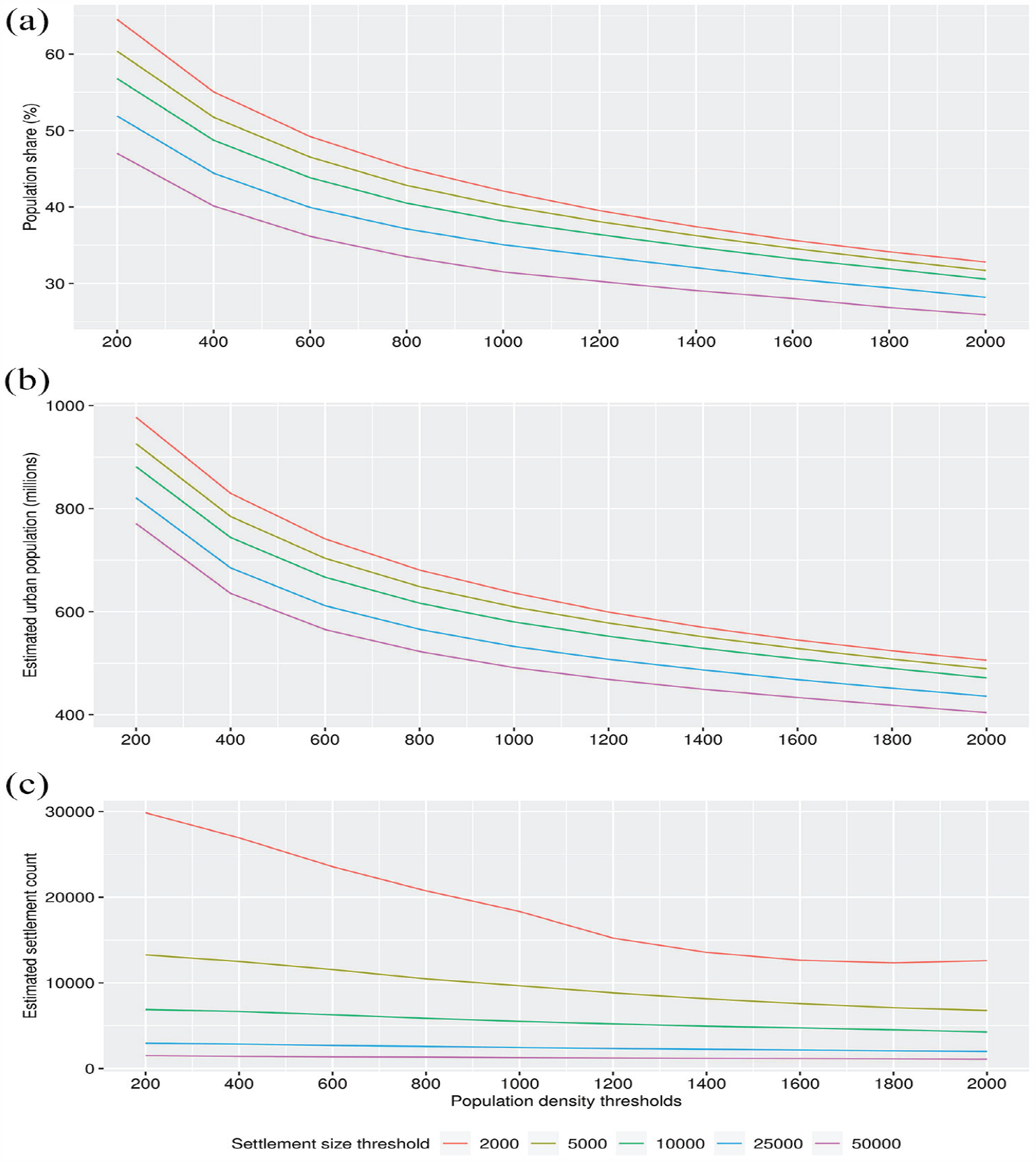
Figure 1 features three graphs showing estimates for (a) the “urban” population share at the full range of population density and settlement size thresholds for all countries in our sample; (b) estimates of the “urban population” (in absolute numbers) for all countries; and (c) estimates of the number of unique “urban” settlements across Africa at each size and density threshold. For each graph, the distinct lines illustrate estimates at each minimum settlement population count threshold (from 2,000 in red to 50,000 in pink).
Population shares, counts and settlements by size and density thresholds
Figure 1a shows that estimates for the share of people living in urban areas across Africa are highly sensitive to the chosen density threshold, with differences of roughly 20–30 percentage points between the lowest and highest densities within each minimum population size threshold. However, these estimates are far less sensitive to the minimum population size thresholds, which display differences of between 5 and 15 per cent within each density threshold. A similar pattern is evident in Figure 1b when we consider urban population counts. Again, the chosen density threshold is the key variable determining variation in urban population estimates. In other words, density is the critical variable in determining how many people are estimated to live in urban places.
Conversely, Figure 1c shows that settlement size thresholds have a more significant effect on the number of places that might be considered urban. Low population thresholds (e.g. minimum populations of 2,000 or 5,000) yield much higher estimates of the number of locations that might be classified as urban. As expected, the number of “urban” settlements generally declines as the minimum density threshold rises, and this is more pronounced for smaller settlements. The y-axis has been log transformed to better display this general decline, so it is worth noting from the absolute values shown that the influence of the minimum population size cut-off is far greater at lower density thresholds.
Overall, Figure 1 suggests that the population density threshold is the key variable shaping variation in estimates of urban shares and absolute population sizes when adopting a strictly spatial-demographic perspective to the measurement of urbanization. However, minimum population count thresholds are shown to have a significant influence on estimates for the number of unique urban settlements. These results confirm the importance of minimum settlement population thresholds in shaping urbanization estimates, and the bias inherent in overcounting small settlements.(38) Nevertheless, decisions surrounding how dense a settlement needs to be in order to be considered urban are clearly of utmost importance.
Next, we turn to a selection of country case studies to determine whether these aggregate results hold at the individual country level. Figure 2 presents estimated urban shares across the spectrum of population size and density thresholds for Nigeria, Rwanda and Zambia. These countries represent diverse cases. Nigeria is Africa’s largest country and has more people living in mid- to high-density places that might be classified as urban than any other. Rwanda is a small and very densely populated country and, as discussed, presents a potential challenge to the spatial-demographic approach. Zambia’s population lives at relatively low-to-moderate densities and, according to UN statistics, the country experienced de-urbanization in the late twentieth century. Together these countries provide a reasonable cross-section in which to ground the continental analysis.
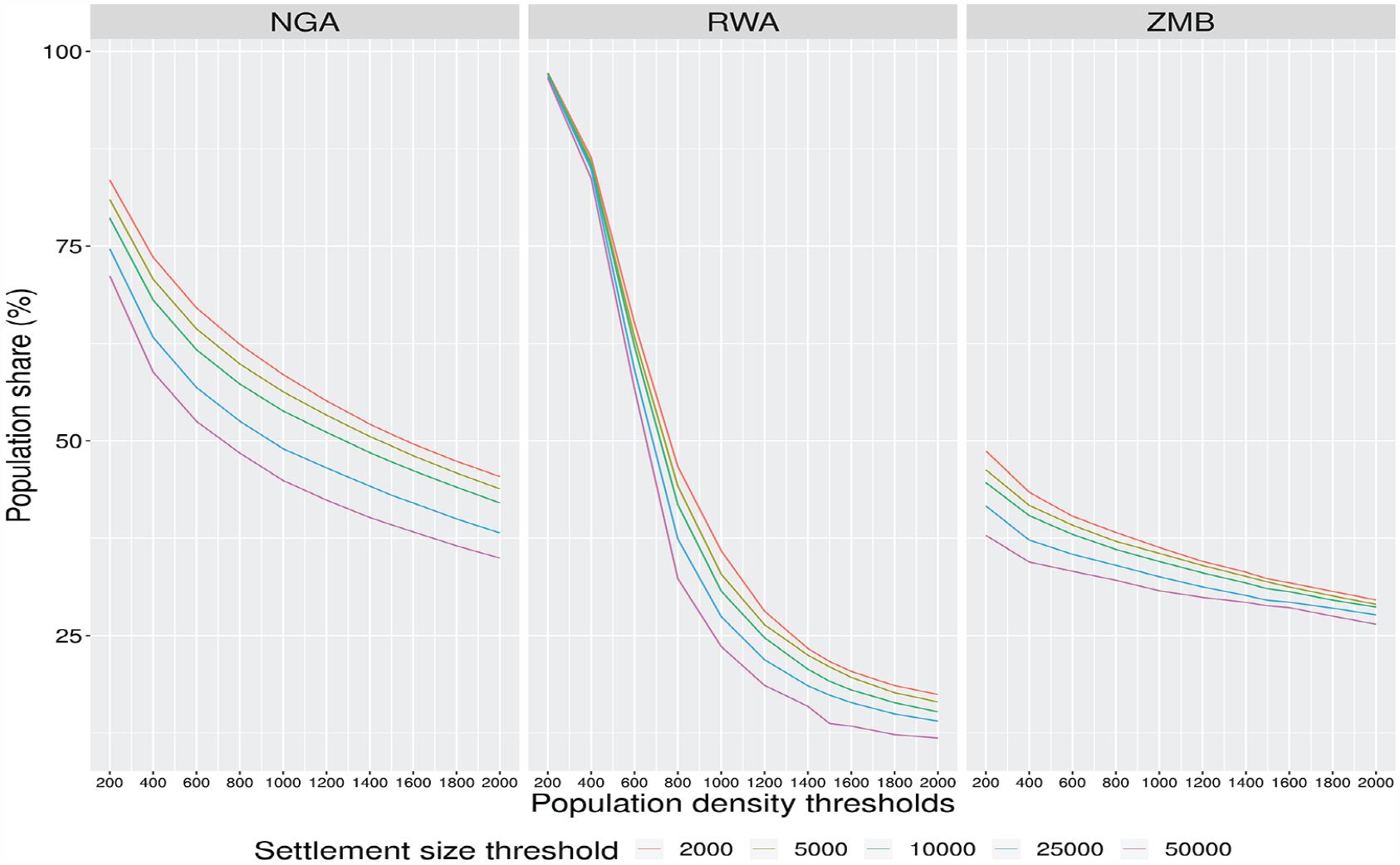
Population shares by population size and density for Nigeria, Rwanda and Zambia
Consistent with the continent-wide analysis, urban estimates are more strongly influenced by the density threshold that is used to define what is “urban”, while population size thresholds exert a comparatively limited influence across these quite different countries. In the case of Rwanda, the country would be considered almost completely “urban” at the lowest density thresholds, but the estimates begin to stabilize above population densities of 800 people per km2.(39)
Figure 3 shows estimated settlement counts for these three countries. In the case of Zambia, increasing the density threshold systematically reduces the number of places that would be classed as urban across all population size thresholds. Nigeria and Rwanda display a more complex picture. In the case of Rwanda, the number of individual settlements with a population density below 400 is very small. As the density threshold rises, the number of settlements initially grows rapidly and then falls at a density threshold of 600 people per km2 for all years and size thresholds. The pattern is less dramatic in Nigeria. While the y-axis has been log transformed to prevent Nigeria masking variation in Rwanda and Zambia, the absolute numbers show that there is still an initial rise in settlements as the density threshold increases, and then a decline after 600 people per km2.
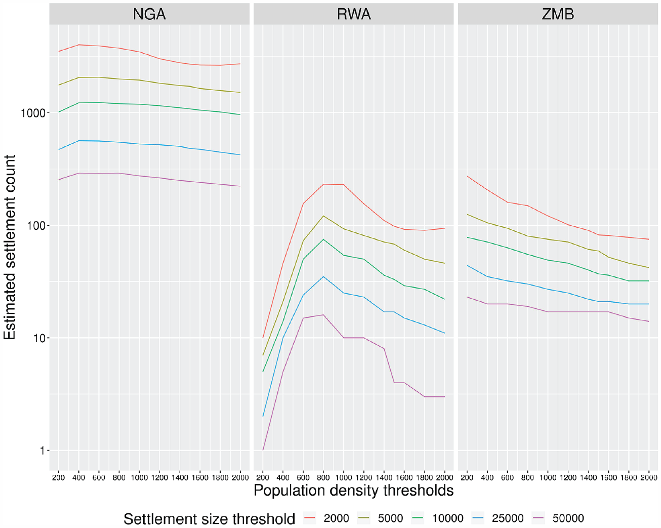
Settlement count by population size and density for Nigeria, Rwanda and Zambia
Overall, these case study analyses support the previous results surrounding the importance of density threshold criteria relative to minimum settlement population sizes, although the latter does have greater influence over the number of distinct settlements identified.
To illustrate why this is the case, Maps 1a–d show the de facto urban extents of four regions in Rwanda, Nigeria and Zambia (two of them in Nigeria) as they would be defined at relatively low-, medium- and high-density thresholds. Map 1a shows that, at a density threshold of 400, which is lower than the average population density for the country as a whole, the core of Kigali would be considered a dense hub in a vast peri-urban sea – an urban region covering most of the inhabited areas of the country. When the density threshold is lifted to 1,200, the core of Kigali remains visible, as well as two satellite settlements, each with over 50,000 people – the cities of Byumba and Muhanga. At a minimum density threshold of 2,000 people, the estimated boundary of Kigali barely changes, but Byumba falls off the map (although it would remain an “urban centre” according to the DEGURBA threshold of 1,500). In short, with a low-density threshold most cells are connected and appear as one enormous urban area; as the density thresholds increase, key nodes in the urban system become apparent and the settled spaces between them are reclassified as non-urban.
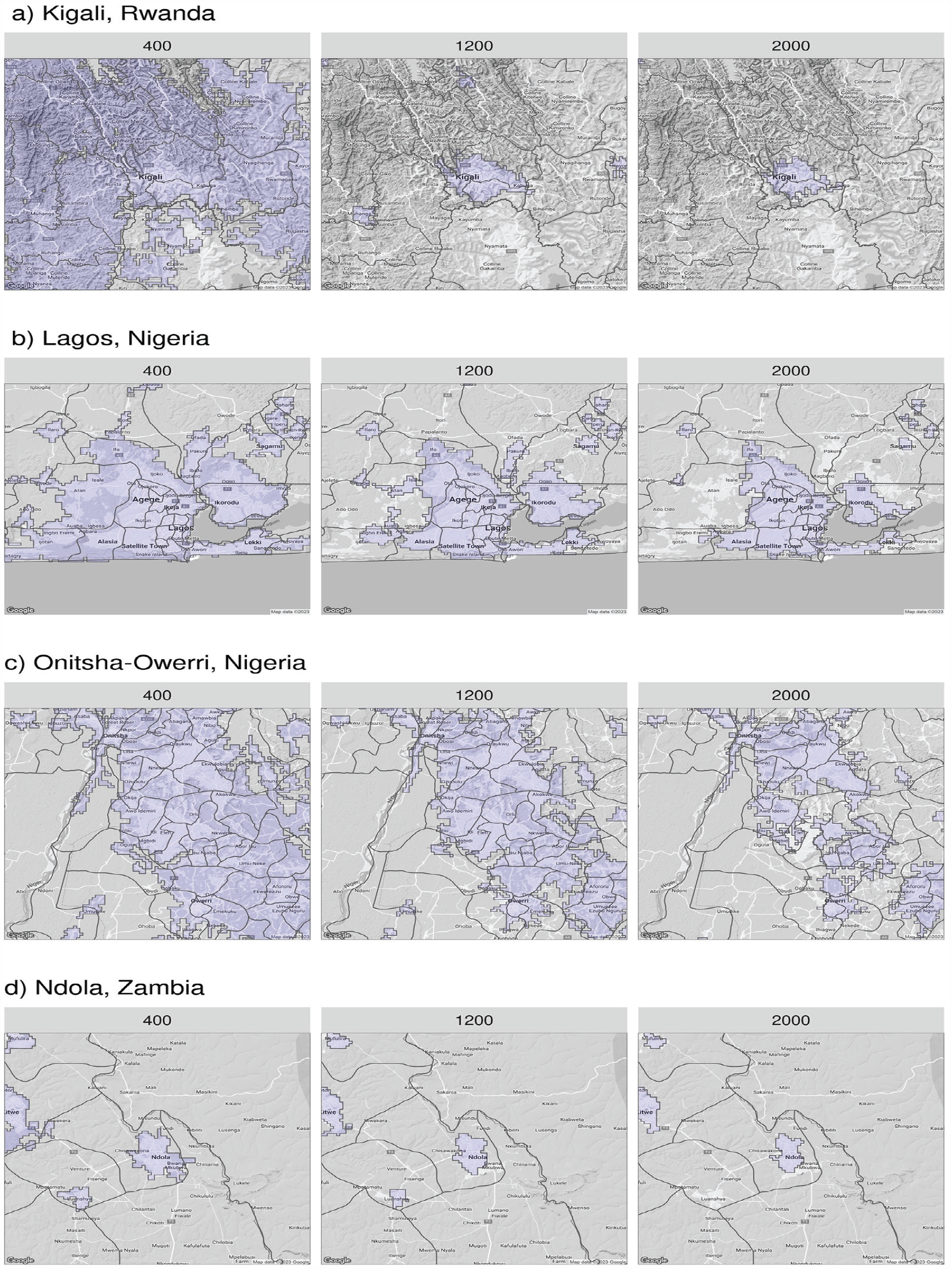
Mapping urban extents with variable population density thresholds
Similar patterns are apparent in Nigeria. Map 1b shows how varying density thresholds influence our perspective on the physical extent of the greater Lagos city region. At 400 people per km2, Lagos is one giant urban region, sprawling across multiple government boundaries. When the threshold is raised to 1,200, Lagos is still large, but distinct and independent nodes emerge, such as Ilaro and Sagamu – a conglomeration of towns with a collective population in the hundreds of thousands.
A similar pattern is evident in the Onitsha-Owerri conurbation, shown in Map 1c. In this case, at density thresholds of 400 and 1,200, a huge continuous agglomeration comes into view, spread over thousands of square kilometres, multiple states and dozens of Local Government Areas. At the highest density threshold, the agglomeration is broken into several nodes (thereby increasing the overall settlement count of the region from a strictly statistical point of view) but nevertheless it remains a highly and largely contiguous “urban” region from a spatial-demographic point of view.
To show why Zambia does not exhibit the same pattern of rising and falling settlement counts, Map 1d shows the Copperbelt region, which hosts the cities of Ndola and Kitwe. At a minimum density of 400, there are four clear settlements. At 1,200, Luanshya drops out, despite having an estimated population in excess of 100,000. At a density threshold of 2,000, Mufulira also drops out, despite having a population greater than 150,000. In short, relatively large, low-density settlements vanish from the frame when high population density requirements are imposed for urban settlement classification. Moreover, we are only considering settlements with 50,000 people or more as “urban” in this case. If a lower threshold were chosen, many more “urban” settlements would come into view.
We have argued that a key advantage of the spatial-demographic approach is the perspective it offers on the relationship between the density of human settlement patterns and economic development. Figure 4 shows the cross-sectional correlation between estimated urban populations at increasing density thresholds (400, 1,200, 2,000) and GDP per capita in constant US$ (2015). Again, we have held the population size threshold constant at 50,000+. We would expect to see a strong correlation between GDP and the proportion of people living in urban areas if the former was significantly contributing to the latter. We see that this is not really the case and there is a fairly weak correlation between the two, indicated by the R-squared values. The strongest correlation, which is found at a moderate density threshold of 1,200 people per km2, only explains 23 per cent of the variation in urban population shares across African countries.
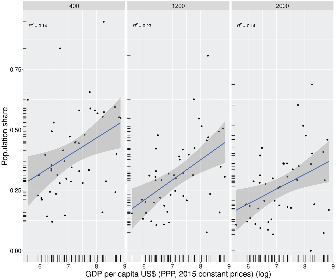
GDP per capita and urban shares in Africa
Finally, Table 1 illustrates the differences in urbanization estimates across data sources and methods for a sample of African countries, focusing on cases where demographic-based estimates deviate most significantly from those reported in traditional UN statistics based upon national definitions. Here, we have fixed the minimum “urban” population threshold at 5,000 people to match the minimum used in the simplest DEGURBA classification scheme, which has just three categories: urban centre, urban cluster and rural grid cell. This sample is drawn from our wider sample that includes all continental African countries and Madagascar.
Comparing estimates of “urban” population share across methods and data sources (in per cent)
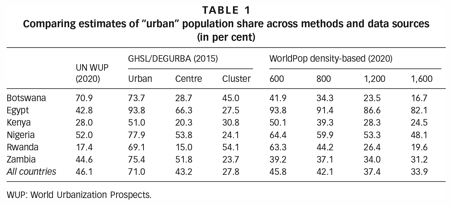
WUP: World Urbanization Prospects.
Several initial observations can be made. First, across all countries, the estimates provided by the Global Human Settlements Layer (GHSL) using the tripartite classification scheme are substantially higher than traditional UN estimates drawing on national definitions and data. Second, our single-density thresholds estimated at a minimum threshold of 600 people per km2 are virtually identical to UN estimates in the aggregate (i.e. for all countries in the sample) but there are very significant deviations from UN estimates at the individual country level. Third, as we increase the density threshold the “urban” share estimate falls in all countries. Turning to individual cases provides further insight into sources of similarity and difference between these various estimates.
Our estimates of the urban share in Botswana deviate significantly from the UN and DEGURBA estimates. At a density threshold of 600, we find a population share of 42 per cent, compared with the UN estimate of 71 per cent and DEGURBA estimate of 74 per cent. An analysis of Botswana’s latest (2022) census data indicates that about 66 per cent of the population lives in cities, towns or villages with a population of 5,000 or more. Collectively these figures suggest a very low level of settlement density despite Botswana being classified as an upper-income country with agriculture contributing just 1.7 per cent of value-added to GDP, according to World Bank data. This is a prime example of low-density economic development.
In stark contrast, our estimate of the “urban” share of the population in Egypt ranges from 82–94 per cent (depending on the density threshold chosen) – 40 to 50 percentage points higher than the UN estimate and similar to DEGURBA estimates. This is despite Egypt having roughly half the GDP per capita of Botswana and a much higher share of agriculture in GDP (11.8 per cent). These “extreme” cases demonstrate the value of disaggregating human settlement patterns from processes of economic development, defined as a structural shift out of agriculture and into tradable goods and services.
The case of Rwanda, highlighted above, also shows just how sensitive estimates are to the chosen density threshold. At a minimum density threshold of 600, twice the minimum used in the DEGURBA classification system, we still estimate an “urban” share of 63 per cent. But the share drops significantly as the threshold is raised, falling to about 20 per cent at a minimum of 1,600 people per km2. Nevertheless, this estimate is higher than the UN estimate of 17.4 per cent. This steep gradient suggests that the majority of Rwandans live at moderate densities, with a comparatively small share living in areas of high density. The implication is that the majority of Rwandans, while still being engaged in agricultural livelihoods, are living at densities approaching, or already within, what would be considered “urban” areas in other parts of the world.
In sum, a simple single-density-based process for estimating “urban” populations reveals the limited correspondence between economic indicators and patterns of human settlement in the context of Africa and raises an important practical question around how we define “urban” from not only a statistical point of view, but also a practical policy perspective.
V. Discussion
Our analysis suggests that a growing number of settlements and regions in Africa should be considered incipient “urban” places from a spatial-demographic perspective. This perspective raises challenging conceptual issues. Can population density alone be sufficient to classify a place as urban? How many people need to live in a settlement to classify it as urban? Is intensive rural densification, as in Rwanda, a form of urbanization?
While it is beyond the scope of this article to pin down precise demographic thresholds for defining settlements or regions as “urban”, we would argue that when the densification or concentration of people in space gives rise to “urban” challenges – such as congestion, public health threats or implicit demand for basic services and amenities at scale – this is a form of urbanization irrespective of the cause of this densification and concentration. Identifying such places is important for decision makers who need to understand the evolving geography of demand for investment and governance mechanisms that can cope with the intensifying externalities associated with population densification.
While the desirability of densification has become a kind of dogma in planning circles,(40) Visagie and Turok caution against “relating density to all-around progress”(41) in the context of Africa. As they point out, much of the continent’s rapidly growing urban population is housed in informal settlements that lack planning and public investment. In this context, what Glaeser described as the “demons of density”(42) can undermine the economic and environmental potential of population density.(43) Rising density can be associated with increased congestion, overcrowding, public health challenges and rising housing costs, which can exacerbate socioeconomic inequalities.(44) The blessings of density cannot be taken for granted. But in Africa, the fact of rising density cannot be ignored.
Given the spatial-demographic trends described above, and projections of rapid population growth and urban expansion in coming decades in Africa,(45) there is clearly an urgent need to address governance and investment challenges to cultivate the benefits of density while mitigating the costs. The concept of building upwards rather than outwards(46) may form a key strategic objective to guide investment and improve the liveability and functionality of emergent urban areas. Furthermore, the diffuse pattern of urban settlement emerging in Africa reinforces the case for considering what Randolph and Deuskar called “Barefoot Planning” at scale(47) given rapid growth in the number of incipient urban places that are being developed without reference to traditional urban planning considerations. Without conscious effort to consider the long-term collective consequences of development at the neighbourhood scale, negative externalities may be locked in. Barefoot planners – community members trained in basic principles and practices of urban planning – could therefore make significant and positive long-term contributions to local urban development as areas transition demographically into places with urban scale challenges (and opportunities).
Africa’s “demographic urbanization” also raises a question of fundamental interest in economic theory: can agglomeration drive economic development? Traditionally, agglomeration has been seen as a by-product and amplifier of economic growth and change. In Africa, a critical question now is whether demographically induced densification will help drive growth and change, and what the distributional consequences might be. Will densification and concentration facilitate greater specialization and exchange, or the ability of small firms to scale up and benefit from associated productivity gains?
V. Conclusion
From a demographic perspective, Africa is urbanizing fast and in ways that often defy traditional assumptions. The growth, densification and concentration of populations is occurring in many places without economic development, as understood in traditional terms. In other cases, rising incomes have not been associated with the kind of spatial-demographic concentration seen in other regions and eras.
Much of our understanding of urbanization and its relationship to economic development has been based on a particular historical interpretation of these processes in “early urbanizers”. But new data and concepts are changing our understanding of these processes. Using gridded population data, we can now easily measure and monitor where and what types of interventions are required to best support human development, understood holistically as improvements in health, education and opportunity. These “goods” require investments in things such as infrastructure, housing, education and health facilities – all of which must be calibrated against demographic patterns and trends.
When it comes to international comparison of human settlement patterns, we support the new UN approach that uses gridded population data and universal settlement size and density thresholds – an approach that is both conceptually and empirically more robust than relying on data from national statistics offices with varying underlying concepts and definitions. However, we would argue that the current thresholds embedded in the DEGURBA methodology may not be appropriate for many countries in Africa. Moreover, greater insights may be gained by using increasingly accurate geospatial population data across a spectrum of thresholds to identify and compare the diverse urban geographies emerging across Africa.
Footnotes
Correction (January 2025):
Funding
We acknowledge funding received from Norges Forskningsråd, grant number 315400 and UK Economic and Social Research Council [ES/R009848/1] (studentship code: 1954246).
11.
Potts (2009, 2012, 2018); ![]() .
.
13.
16.
Fox (2017); ![]() .
.
18.
20.
Turok (2018); ![]() .
.
35.
“Queen contiguity” refers to the game of chess, in which the queen can move to any adjacent square. In this context the eight pixels surrounding each grid cell are its contiguous neighbours.
36.
In spatial analysis terms this means that we search for connections, corridors of densely populated cells, to all higher-order neighbours up to the order of n.
39.
Although not reported here to save space, the urban population plots for these three countries are similar to the share plots and the plots for all African countries.