
Abstract
Capital investment-laden green blue infrastructures (GBI) are being globally celebrated as harbingers of urban resilience to address environmental risks. These technocratic designs exclude historical and micro-political processes shaping urban environments. It is within this context that exposure to social sciences frameworks remains significant. Here, I formulate and deploy historical urban political ecology (HUPE) to explore the mutual relationship between Kolkata and her wetlands, finally demonstrating that cities need to be perceived as complex and adaptive “living systems infrastructure” evolved over time, across an intersecting array of technological apparatuses and social arrangements through constant interactions between human and non-human actors. Beyond linear choreographies of power equations, HUPE conveys the “plural” by exemplifying collaborations, compulsions and contingencies that mediate urban ecologies. I argue that HUPE is an enabling framework, eliciting emancipatory possibilities within political ecology by envisioning the translation of epistemological insights into implementable actions, towards more just and resilient urban ecologies of future.
I. Introduction
Infrastructure planning and management is the contemporary focus of any discussion on urban sustainability and resilience during the Urban Anthropocene. Numerous technocratic and investment-laden approaches to urban sustainability such as smart, zero-carbon, U(eco) and compact cities have flooded the urban scene in the last two decades. These tend to emphasise the role of innovative technologies in reducing greenhouse gas emissions and achieving other environmental goals.(1) Meanwhile, United Nations agencies have laid out a vision for “sustainable urbanization”,(2) including Sustainable Development Goal 11 (sustainable cities and communities) that includes targets such as safeguarding natural heritage and providing universal access to green and public spaces. These discourses and trends help to explain growing attention to urban green and blue infrastructure to enhance urban resilience within the contemporary context of disruptive environmental risks, including climate change.
Drawing insights from critical urban scholarship that interrogates capital-intensive models of urban sustainability,(3) I argue that technocentric initiatives at best address ecology “in” but not the ecology “of” cities.(4) Such infrastructural planning and upgrades are too often ahistorical and apolitical, and therefore do not reflect the needs, desires, or experiences of the multiple actors – human and non-human, living and non-living – that have shaped urban nature. I propose that there is the potential to complicate, critique and improve such interventions by studying urban flows of resources and their (unequal) distribution across changing social configurations of cityscapes. A patient approach that embraces complexity is necessary to nurture resilient infrastructure, which, as Carlisle (2013) points out, “grows slowly but extensively, building up relationships in steps and bounds, integrating into surrounding systems, flows and entities; it evolves and shifts till it is essential and invisible”.(5)
In this article, I have applied historical urban political ecology (HUPE) approaches within the city of Kolkata in India. By triangulating a wide range of datasets – archival/historical sources, grey literature and ethnography – I have unravelled different accounts of the making and remaking of Kolkata’s urban ecologies during different historical and political epochs. Through HUPE, I have surfaced alternative “storylines” about the co-production of urban nature in Kolkata. The key storylines comprise the dominant or mainstream discourses, counter-narratives, and suppressed or sublimated sagas of the city’s interactions with her wider environments. I assert that all of these storylines should be accommodated in understanding urban nature and planning green and blue infrastructures in Kolkata.
In the next section, I introduce HUPE and explain the value of this interdisciplinary, politically sensitive approach in the context of contested urban environments. I also explain my methodology. I have then divided the remainder of the paper into three sections that each represent alternative storylines of Kolkata’s natural environment:
a) the colonial-era remaking of a “wild”, “unhygienic”, and “insanitary” space;
b) the wetlands as an important source of provisioning and regulating ecosystem services; and
c) the much-needed space to provide urban housing and enable development.
Each of these sections are also plural and non-linear, clashing and converging with each other at different points in history and in different parts of the city. These wider historical revelations are crucial to interrogate reductionist discourses that position the state against communities, or development needs against ecological services. Instead, we can perceive cities as “living-systems infrastructure”, deeply imbued and enmeshed with more-than-human elements. Finally, I note different types of environmental activism that have shaped the wetlands over recent decades and the extent to which these have gained widespread recognition and support. The article ends with the conviction that HUPE makes it possible to map plural voices, and hence identify and craft collaborative opportunities to advance urban sustainability and resilience.
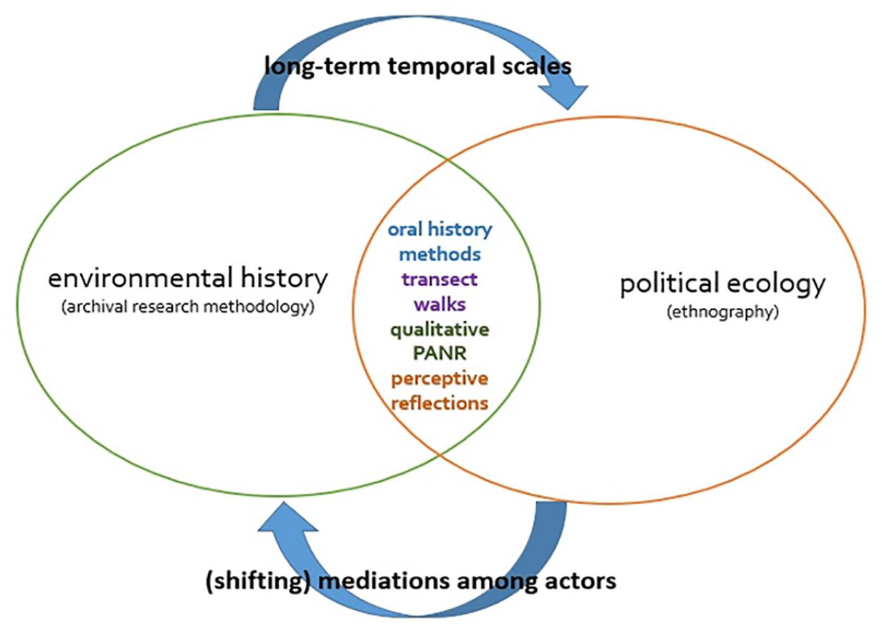
II. Historical Urban Political Ecology (HUPE)
Political ecology emerged as a radical interdisciplinary domain and community of practice(6) during the late 1970s. Drawing inspiration and insights from the Marxian framework of political economy, the discipline emerged in response to apolitical studies of the environment. Political ecologists seek to understand the environment as simultaneously physical and social, accounting for how the choreographies of power determine the uneven distribution of environmental resources and risks among divergent social groups and regions.(7) The domain started gaining ground in the 1980s, particularly in studies of the Third World context of “environmentalism of the poor”.(8) Growing attention to the shifting, sprawling and splintering urban geographies of the global South – dotted with inherent crises of “urbanization without growth”(9) and “urbanization without infrastructures”(10) – has laid the backdrop to foreground the “urban” in political ecological analyses, spearheading and consolidating the sub-field of urban political ecology. While urban metabolism, resource circulation and ecological flows have been key concepts, urban political ecology also provides useful analytical frameworks to study the co-production of urban nature, bringing to the fore, “who controls, who acts and who has the power”.(11)
A separate but related approach is environmental history: the study of past interactions between nature and humanity. Widely thought to be pioneered by US and Indian historians,(12) political ecologists quickly recognised that the application of historical scales in political ecological analyses enables the researcher to unravel socio-ecological configurations through the examination of long-term systemic conditions and resource allocation or accumulation processes of the past. Davis (2015) suggests that “it is precisely the historical components of political ecology research that help to guard against ‘apolitical’ analyses”.(13) The significance of critical historical approaches has been recognised in the early tradition of political ecology(14) with scholars subsequently carving out “historical political ecology” as a sub-field within the domain.(15)
To date, urban environmental scholarship has failed to convey the more comprehensive and all-encompassing accounts that might be possible through cross-fertilisation of conceptual frameworks and methodologies. Although some urban political ecologists apply history as the background to reveal unjust urban environmental conjunctures rooted in unequal resource allocation,(16) urban environmental historians seldom accommodate the contemporaneous.(17) Political ecological perspectives could equip environmental historians to meticulously investigate power dynamics in resource allocation and access, combining archival and ethnographic research to objectively establish the link between past, present and posterity. Meanwhile, political ecology too often offers a narrative of decline, inveigled by reductionist mapping of power hierarchies.(18) Environmental history could guard against this tendency through surfacing sublimated and counter-narratives about the relationships between people and ecosystems.
I assert that the HUPE framework, formulated through the cross-fertilisation of political ecology and environmental history and applied to the urban realm, is more inclusive. Its application has allowed me to comprehend urban ecological transitions by triangulating information from multiple sources and stories narrated by multiple actors at different points in history. The detailed explorations of Kolkata’s social, economic and environmental infrastructure over one-and-a-half decades has exposed me to competing narratives and claims surrounding Kolkata’s urban ecology.
This paper relies on the following sources, and I have constantly compared information from these multiple sources to unpack the relationship between Kolkata and her wider ecological infrastructures over time:
First, archival research. I have consulted primary historical sources such as technical designs and maps, revenue reports and proceedings, correspondence, gazetteers and grey literature (unpublished primary documents preserved at repositories of non-governmental organisations [NGOs] and grassroots institutions).
Second, given that Watts warns against over-dependence on archives as they are mainly produced by the state,(19) I have also undertaken ethnographic research, including 12 key informant interviews with municipal engineers, irrigation (executive and sub-divisional) officers, local pump operators and lock-gate personnel, projects-in-charge, managers, secretaries, leaseholders, fishers involved in running and managing bheris (Bengali word: manually excavated sewage-fed fishponds), and secretaries and members of environmental NGOs and grassroots organisations. I have conducted eight focus group discussions (FGDs) in the wetlands with elderly fishers and women workers, as well as FGDs with mixed groups of people involved in waste-recovery practices in the East Kolkata Wetlands (EKW). To explore specific challenges and potentials faced by different bheris as per their ownership patterns, I have focused on six particular bheris as case studies. These include: government bheris (Nalban and Goltala), cooperative bheris (Captain Bheri and Baro Chaynavi Samabay Matsya Samity) and private bheris (Jhagrashisa and Munsher Bheri).
Third, I have completed transect walks and incorporated visual/perceptive reflections at key points, such as the Bantala lock gate, pumping stations, sluices, specific bheris, and the wetland entry point of the main sewage canal in this long urban ecological research (Figure 1).
The HUPE framework
III. Colonial Hydrology and the Making of the Modern City
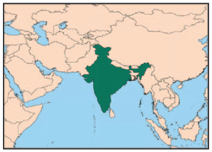
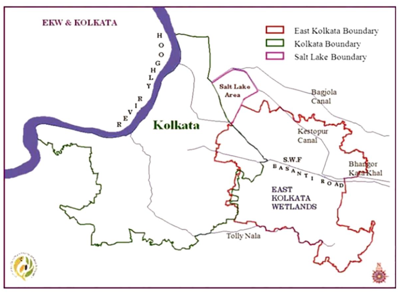
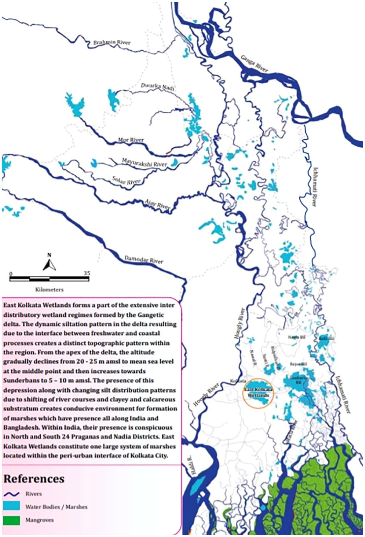
Kolkata is located in the tropical delta and estuaries on the edge of the Sundarbans, the largest mangrove forest in the world. The Bhagirathi-Hooghly River (a major distributary of the Ganga River to the west of Kolkata), Bidyadhari River, Adi Ganga River, numerous inlets and creeks in the east, and the vast saltwater marshes on the further east are all part of this dynamic deltaic system (Map 1). The saltwater lakes are formed by tidal rivers flowing from the Bay of Bengal, especially the Bidyadhari.
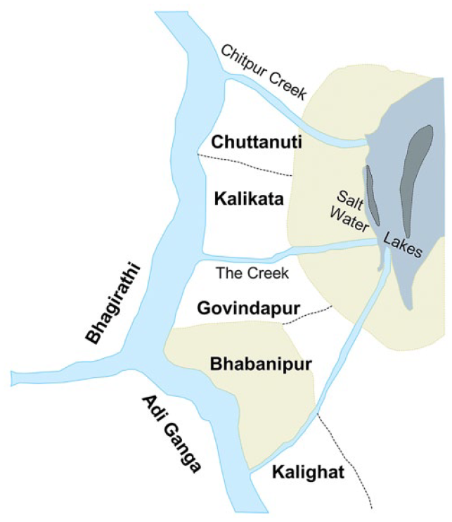
The earliest map of the site
Archival records demonstrate that when the British first arrived at the site during the last decade of the seventeenth century, they found the region to be “unhygienic” and “wild”. Fever-committee reports and medical topography notes of the eighteenth and the nineteenth centuries describe how the saline water marshes on the eastern part of the site were “highly productive of malaria – the air, when the wind is eastward of us has to find its way to our city, only over swamps, jangals [forests] and villages themselves highly productive of the same malaria, and therefore not calculated to dispel the evil”.(20) In practice, the wild marshes served as the breeding ground for mosquitoes that carry malaria and other vector-borne diseases.(21)
From the mid-seventeenth century, the colonial archive is dotted with anxieties, apprehensions and complaints about this marshy terrain and “insanitary” space. However, the same archive and datasets(22) confirm that Kolkata was not a “chance-directed” and “chance-erected” city but a deliberately selected site. The British conducted meticulous cost-benefit exercises over a series of surveys to ascertain the strategic value of this location, ecology and terrain.(23) The tributaries and spill channels of the Ganga River could be used for communication and trade between Kolkata and her fertile hinterlands, catering to the needs of a budding city and global economic enterprise.
The subsequent step was the elaborate colonial project of the drainage, reclamation and repurposing of the marshes. The natural ecology was transformed into tamed, networked infrastructure through a series of interventions: artificial cuts and excavations, and the construction of pumping stations, lock gates, sluices and mortar sewers. The resulting Eastern Canal System accomplished the dual functions of transportation (connecting the city with its hinterland for trade and other revenue extraction) and drainage–sewerage–sanitation, enabling cost-effective delivery of urban utilities (Map 3).(24) Tollage receipts from colonial proceedings and revenue records shed light on huge profits yielded on investments from this networked infrastructure during the nineteenth and the early part of the twentieth centuries.(25) Meanwhile, the Bidyadhari River was appropriated as the main outfall channel (for the disposal of human waste) until the early twentieth century. This enabled sewage farming and fishing to be practised by embanking parts of the saltwater lakes. Between 1868 and 1869, experiments were conducted to grow rice, vegetables, cotton and cattle fodder in sewage farms by the-then health officer, Fabre-Tonnerre.(26) In 1928, the Bidyadhari River was officially declared to be dead due to both natural reasons and artificial interventions as part of the colonial canal network initiative.
Archival correspondence and reports between the 1920s and 1940s show that government agencies and departments wanted to harness the integrated canal–wetland system connecting the city and her periphery.(27) After detailed debates and consultations, the Kulti Outfall Scheme was implemented in 1939 (Map 2).(28) The dry-weather flow and the stormwater flow canals from Bantala to Kulti (17 miles) were constructed to carry wastewater out of the city (Map 3). Technical designs, including 40-foot-deep sedimentation tanks at Bantala (1945), were laid out by the Calcutta Corporation (as it was then known) and the Department of Fisheries of the government of Bengal, to promote low-cost, ecologically subsidised fish production from municipal wastewater that would simultaneously empower local communities and establish a sustainable revenue regime for the state.(29)
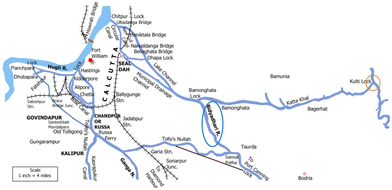
The Eastern canal system and the Kulti lock gate
The East Kolkata wetlands
I consider the construction of the Kulti Outfall Scheme as a crucial moment in the ecological history of Kolkata because the diversion of the city’s outfall to the Kulti from the Bidyadhari (i.e. further east) led to a major transformation in the constitution of the marshes – from tide-fed to wastewater-fed wetlands (Maps 2 and 3). The sedimentation tanks did not continue to function, but an adequate waterhead was additionally raised for supplying sewage to the bheris by gravity. This led to the extension of wastewater fishponds further east and southeast for about 8,000 hectares. The changes to the natural and built infrastructure led to a decline in the salinity of the saltwater marshes from 800–1,200 parts per million to 500–600 parts per million.(30) Thus, the saline marshy area behind Kolkata gradually evolved into sewage-rich marshes bereft of salinity,(31) which came to be known as the East Kolkata Wetlands (EKW) (Map 4).(32) An elaborate system of municipal–local apparatuses and social arrangements evolved over time to manage these wetlands.(33) EKW remains the major sink to receive and recycle Kolkata’s wastewater, which led interviewees to grant them the epithet of the “natural kidney” of the city and making her “ecologically subsidised”.(34)
The East Kolkata wetlands catchment and the interfluvial area
The Eastern Canal System no longer functions as a commercial transport network. Limited historical records on canal traffic since the 1920s and subsequent archival silence indicate the diminishing importance of canal trade and transportation. The Tolly’s Nullah and the Beleghata Canal functioned until the 1970s, and interviews with elderly people living in proximity suggest that boats still plied through the canals, carrying goods such as bricks, oil and rice. However, these waterways too have now transformed into drainage and sewerage channels only. Undredged and untreated, the clogged canal network has dwindling abilities to manage the drainage load of the ever-expanding metropole.
This narrative of the degradation of the Eastern Canal System is common in Kolkata. The colonial and post-Independence eras are carved out as distinct chronological categories, juxtaposed against each other, with the canal system’s decline seen as the result of contemporary bureaucratic reluctance, indifference and neglect, unlike the preceding regime of colonial enthusiasm and technocratic efficiency. I have previously critiqued this reductionist interpretation; using archive material, I have demonstrated how the declining importance of canals has to be historically contextualised within the larger interplay of political, economic and technological forces.(35) Steamer traffic replaced canal boat traffic and in turn was replaced by the rail network that offered greater returns on investments. In the next section, I further enrich this alternative narrative by expanding upon the ways that Kolkata’s green and blue infrastructure has been used and maintained in post-colonial India.
IV. Converting the Canal Network Into Living Systems Infrastructure
The EKW recycles 750 million litres of municipal wastewater, produces 22 tonnes of fish and 150 tonnes of vegetables per day, and caters to the survival needs of 200,000 people.(36) To date, Kolkata has no sewage treatment plants within its municipal boundary and EKW treats almost 80 per cent of the city’s effluents and waste. These free ecosystem services would have otherwise cost the city around US$ 80 million per annum.(37)
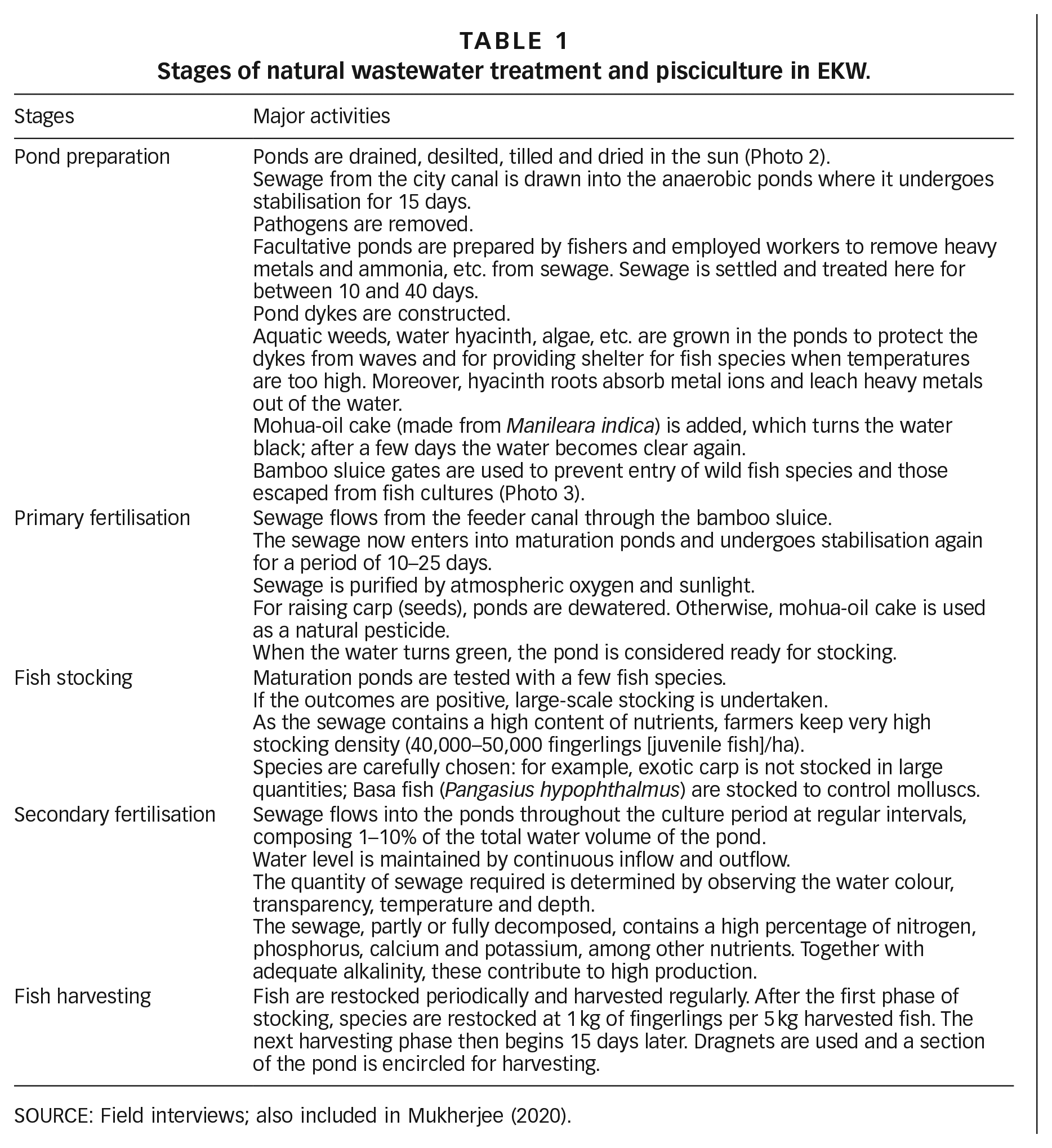
The mechanism through which effluent is treated involves extensive humanmade and natural waterways, biogeochemical processes, and coordinated efforts at state, municipal and local levels. There have been extensive efforts to maintain the canal–wetlands system in contemporary times. Kolkata Municipal Corporation (KMC) carries out frequent clean-up activities by employing local youth on several stretches of the canal network, the latter attempting to elicit awareness among canal bank inhabitants not to throw inorganic waste into the water (see Photo 1). Under the Kolkata Environmental Improvement Investment Program (KEIP) funded by the Asian Development Bank,(38) approximately 70 kilometres of inlet canals have been dredged, and six sluice gates and nine culverts constructed to manage wastewater and sewage distribution. These improvements have often been neglected in the mainstream declensionist narratives about the EKW.
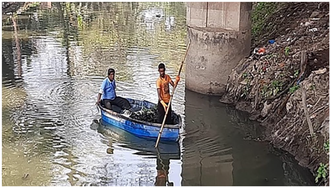
KMC youth volunteers cleaning a stretch of the Tolly’s Nullah
Municipal wastewater is channelled by the canals and underground sewers to the pumping stations, to be then pumped into open channels through six terminal pumping stations in the KMC area: Bagjola, Chowbhaga, Topsia, Dhapa Lock, Ballygunge and Palmer’s Bridge (formerly Palmer Bazaar). The primary municipal dry-weather flow canal carries wastewater from the pumps to the bheris, which receive pre-settled sewage from the canal through an intricate network of locally excavated secondary and tertiary channels with local names such as the Paran Chaprashir Khal, Lalkhuti Khal and Ghoser Khal (khal is ‘canal’ in Bengali). Wastewater flow is ensured through a regulation mechanism at the Bantala lock gate under the management of the government of West Bengal’s Irrigation and Waterways Department (I&WD), which is also responsible for maintaining the municipal canal and associated sluice gates (Map 5).
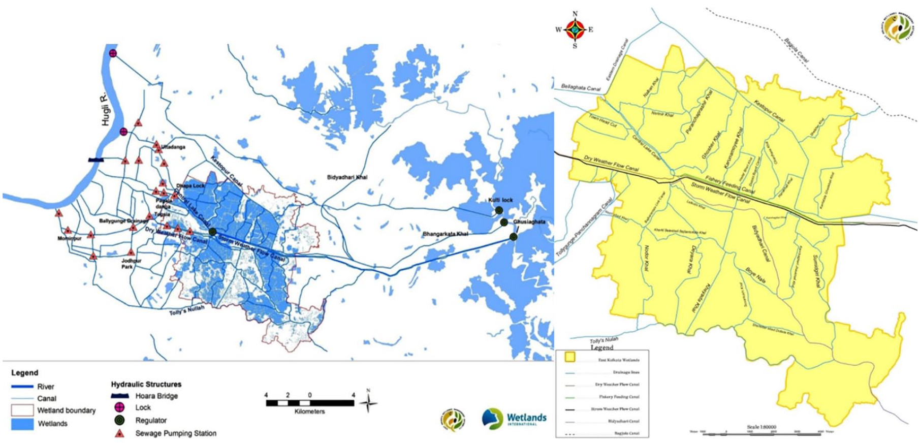
Kolkata’s intricate drainage–sewerage–wetlands system
Wastewater reaches the inlet canals from the municipal canal via gravity. Its distribution among bheris is then regulated by wastewater-user committees represented by fishers, private bheri-owners, cooperative members and others. The access to and intake of wastewater by each shared bheri is controlled by the locally constructed lock gate system (known as kapat in the local language). While one particular bheri receives wastewater, the kapat of other bheris in the shared system are closed to ensure just distribution of allocated wastewater. The size of bheris, roughly ranging between 5 and 50 hectares, is the key variable in deciding on wastewater quotas and time of intake, varying from a few hours to three days a week. Interviewees stated that the wastewater-user committees meet every month to discuss and fix wastewater quotas and related issues to ensure more effective fish production.(39) Locals seldom violate the agreements due to fear of social ostracism.
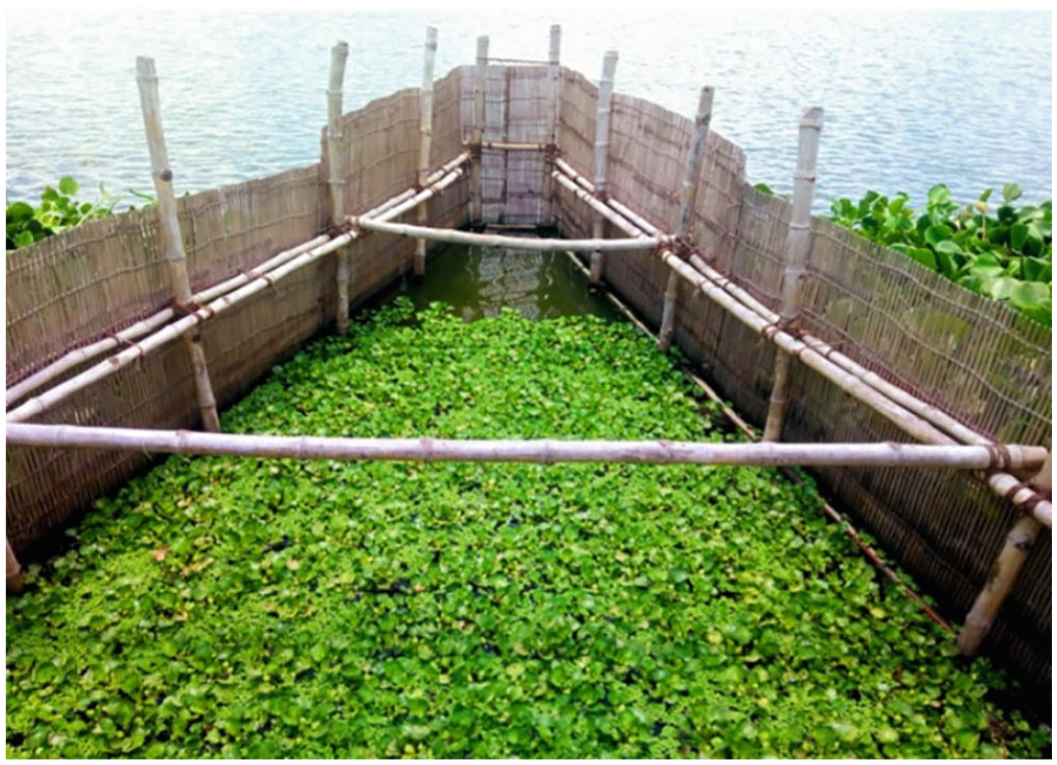
The bheris act as waste stabilisation ponds that retain sewage as the wastewater is treated according to local knowledge and experiments. Three different varieties of waste-stabilisation ponds exist: facultative ponds, anaerobic ponds and maturation ponds. Sewage is retained in an anaerobic pond following a prolonged retention phase in a facultative pond before the final entry of the partially treated sewage into the maturation fishpond. In the primary and secondary stages, the biochemical oxygen demand level reduces through sedimentation or settling of sewage. Five distinct phases are involved in the fish production and sewage-treatment process: pond preparation, primary fertilisation, fish stocking, secondary fertilisation and fish harvesting (Table 1).
Stages of natural wastewater treatment and pisciculture in EKW.
SOURCE: Field interviews; also included in Mukherjee (2020).
Fishers cleaning ponds manually
Bamboo sluice gate
The wetland ecology around Kolkata today is a vivid illustration of more-than-human entanglements and agencies, collectively determining successful fish harvests in wastewater. For example, elderly women collect snails from the pond floor to sell. The snails are crushed and used to feed the ducks who paddle in the ponds and whose droppings offer a valuable source of fish feed, triggering fish growth and production.
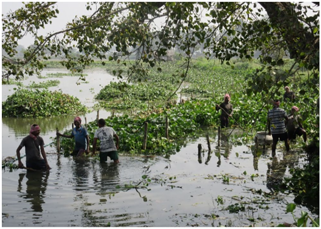
Water hyacinth also performs multiple functions such as providing shelter to fishes during the day, absorbing toxic metals from effluent and preventing waves generated in water bodies from eroding the banks of the bheris. To prevent waves reaching from the shore, locals create and retain a three metre-wide layer of water hyacinth behind a fence comprised of two poles dug in the floor of the pond and tied with an iron wire (Figure 2). The use of water hyacinth as a purification agent and buffer is a traditional practice adopted by many generations of fishers in the EKW. Microbes including phytoplankton are significant actors expediting bioremediation in fishponds. When sunshine reaches the bheris in the EKW, the algae population grows and the pond water shimmers with a lush green shine. Different bacterial strains break down the organic matter in the bheris to produce oxygen and kill pathogens. Some of the fish varieties feed on algae, increasing the fish yield.
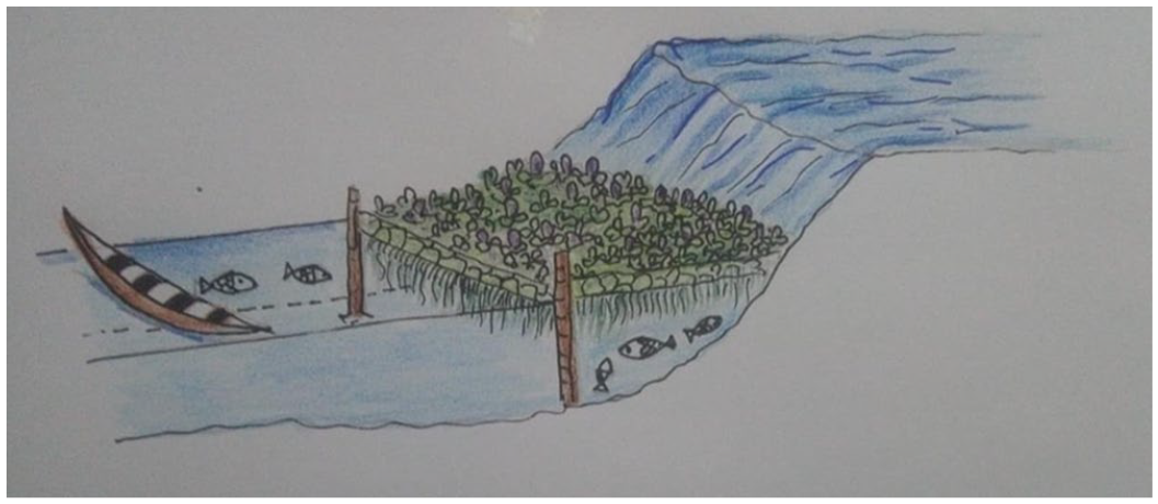
Local use of water hyacinth to prevent bank erosion
In contrast to the colonial era that depended on building infrastructure such as canals to harness the wetlands, the fishers focus much more on creating cost-effective and easily manageable biological systems to achieve their goals. Although they actively manage large tracts of the wetlands, they are not always recognised as environmental actors. The 12,500 hectares of EKW was designated a Ramsar site in 2002 (a wetland site designated to be of international importance under the Ramsar Convention because of its biological diversity), in part reflecting the fishers’ activities. However, it is important not to idealise the use of animal and plant species by the fishers as inherently “natural” or ecologically beneficial:(40) wild hyacinth, for example, was introduced to West Bengal by its British rulers, where it proved to be highly invasive. Left unchecked, it threatens native plant species and clogs water bodies.(41) The combination of species and levels of sewage therefore must be carefully managed by the wastewater-user committees to avoid eutrophication of the ponds, manage introduced species, and maintain the biodiversity of the EKW.
The latest report published by the East Kolkata Wetlands Management Authority (EKWMA) assesses land-use and land-cover changes between 2000 and 2019 using satellite data. Interestingly, while a long-term change assessment based on remote sensing images of 1973, 1989 and 2010 indicates continuous shrinkage in sewage-fed fisheries, the land used for this purpose has increased since 2015 (Map 6).(42) The report attributes this increase in fish farm area to the increased availability of wastewater as the result of canal desilting measures – a conclusion confirmed by cooperative and private bheri owners in recent interviews.(43)
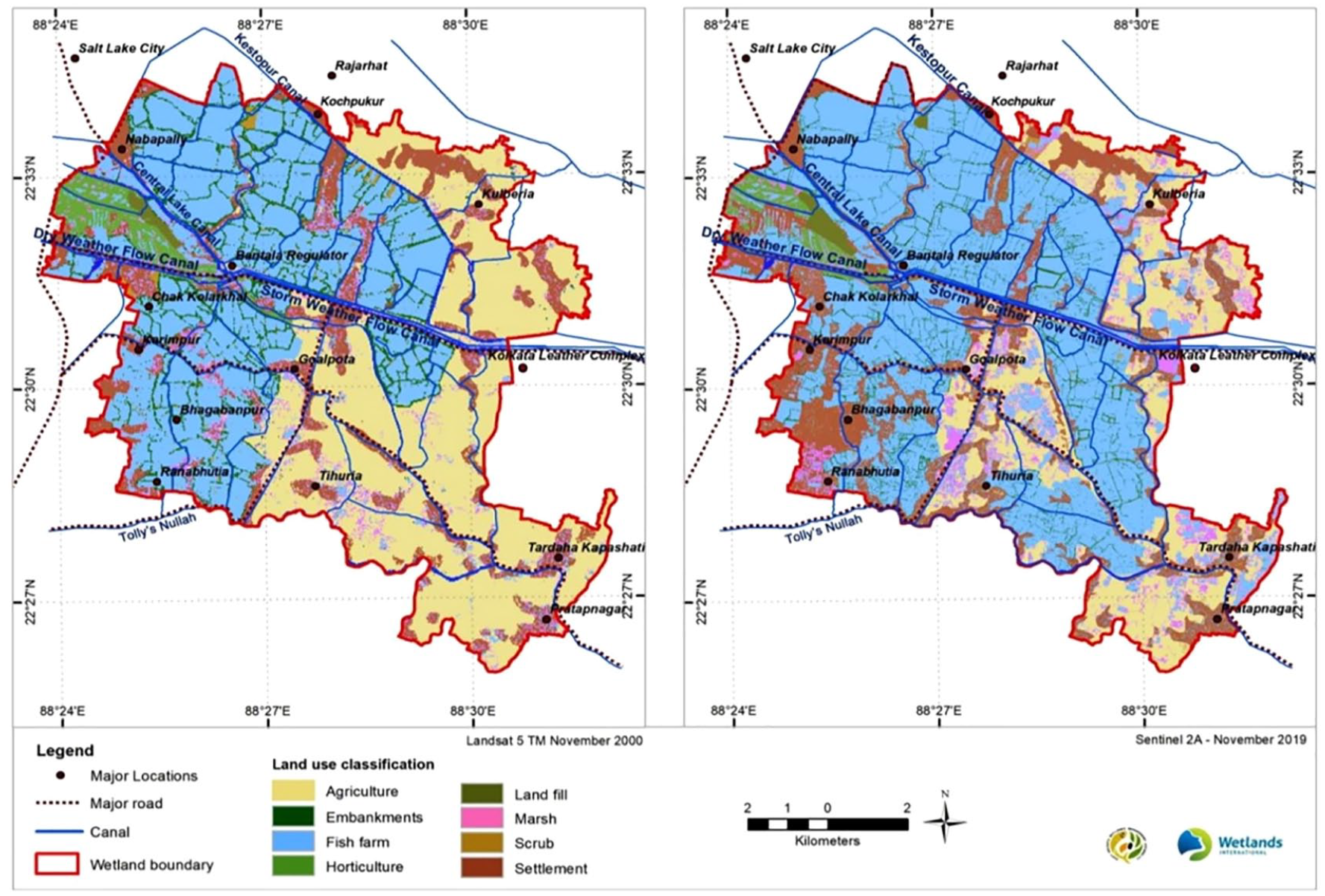
Land use and land cover of EKW between 2000 and 2019
V. Much-Needed Housing or a Speculative Spree?
Massive transformation in land use has occurred in and around Kolkata since the 1950s, with new townships and development projects leading to the constant shrinkage of waterbodies and wetlands.(44) The large-scale conversion of natural ecosystems into agricultural and urban land is unsurprising, given that Kolkata’s population has tripled from less than five million people in 1950 to nearly 15 million today.(45) Thus, the wetlands have had to make way for real estate, epitomising “a saga of space, capital and people in the vortex of globalised time”.(46)
One of the dominant discourses about Kolkata’s urban ecology throughout this period focuses on the degradation of the wetlands and displacement of marginalised communities. Since 2015, journalists have documented how the Kolkata Municipal Corporation and I&WD are discharging municipal effluent into the outfall system rather than to the feeder canals. This means that the wastewater supply, the lifeline of the sewage-fed EKW, is not flowing to fisheries on Kolkata’s eastern periphery. Some leading environmental journalists argue that this is an intentional strategy to destroy livelihoods and thus compel fishers to sell their bheris to the real-estate market.(47),(48) Such narratives are reinforced by other development projects in the EKW, such as the state government’s plans to construct a five kilometre-long flyover along 146 tiers spanning eight large bheris.(49)
Speaking to officials and engineers from the Kolkata Municipal Corporation and the I&WD, it is apparent that the regulation of wastewater is shaped by multiple pressures that need to be accommodated in urban environmental planning, management and governance. Officials open the Bantala lock gate to lower the wastewater level in the main canal; during monsoons, this facilitates a faster flow of sewage and stormwater to reduce the risk of urban flooding. The threat of waterlogging in the deltaic city of Kolkata, densely packed with informal settlements, looms large; and the degradation of both natural and humanmade blue infrastructure increases Kolkata’s vulnerability to floods.(50) Officials are therefore apprehensive about catching media attention and provoking criticism of their departments if they do not manage flood risks. On the other hand, opening the Bantala lock gate obstructs the wastewater supply to the inlet canals and hence the bheris. Kolkata Municipal Corporation and the I&WD are thus caught between the needs of low-lying urban residents and fishers during the monsoons. The media projection that the state is deliberately jeopardising fishing livelihoods to create land for real-estate development is therefore likely an exaggeration.
Decisions by other government agencies and departments underscore that there is no systematic effort to convert the wetlands into built-up areas. In a joint move in 2012, Kolkata Municipal Corporation, EKWMA and Kolkata Police demolished a wall around the Collector Bheri to stop land speculation. In 2013, a 10-hectare bheri that had been partially filled up illegally was re-excavated and restored. The former was a result of continuous pressure from environmental action groups; the latter from fishers approaching the state environment minister. More recently, in 2019, Kolkata Municipal Corporation pulled down two buildings in EKW as part of a larger demolition drive against encroachment following orders by the National Green Tribunal (NGT).(51) It can be considered a giant step towards improved wetland protection that the administration acted without being repeatedly impelled, providing reassurance that EKW should be envisioned as more than “real estate in waiting”(52) or “real estate in making”.(53)
VI. Varieties of Urban Environmentalisms
The EKW conservation movement has sometimes been portrayed as elitist. I believe that this argument results from focusing on specific subsets of environmental action, such as judicial activism through public-interest litigations.(54) These sources reveal only a small component of the environmental activism surrounding the wetlands between the 1970s and the present. For example, protests have also been launched by fishers against the bheri owners, often backed by the then pro-poor leftist government, to ensure for example tenure rights and wage protection that would allow the fishers to continue managing the sewage-fed parts of the wetlands as they have done for decades.
Similarly, we can construe two distinct types of activism surrounding the conservation of the Adi Ganga–Tolly’s Nullah against the metro-rail project.(55) The urban middle classes were fighting to preserve the “heritage” river using non-violent methods such as media activism, seminars, peaceful rallies and judicial activism. Grassroots organisations were fighting against the removal of squatters and informal settlers from the banks of the waterway. Their activism often took a brutal turn as evidenced through violent clashes between police and protesters. The failure to recognise their common cause and the lack of integration between the two groups played an important role in the outcome of the movement: the metro-rail project was executed, obstructing the water flow through the river-canal and displacing squatter dwellers from its banks. The breadth of tactics including protest rallies, public interest litigations and online eco-activism signifies wide and sustained interest in saving Kolkata’s wetlands over the last five decades.(56)
In 2006, the EKWMA was established as a statutory body for wetland conservation and management. This statutory body has 19 members drawn from government and civil society, including leaseholders, fishers and cooperative secretaries and members. Stakeholder meetings are held at frequent intervals to discuss challenges and possible solutions to facilitate wetland functioning. EKWMA also organises onsite awareness-raising programmes such as exhibitions, workshops and celebrations of World Environment Day and World Wetlands Day. In spite of some failures and several complaints against conversion of bheris pending at local police stations, EKWMA is doing a laudable job in terms of improving information, identifying challenges, and building a shared understanding of how to keep the system functioning effectively. The latest 2021 EKWMA and WISA report consists of land use, land cover and catchment maps using sophisticated cartography, which I consider to be a major step in the right direction.(57)
VII. Conclusion
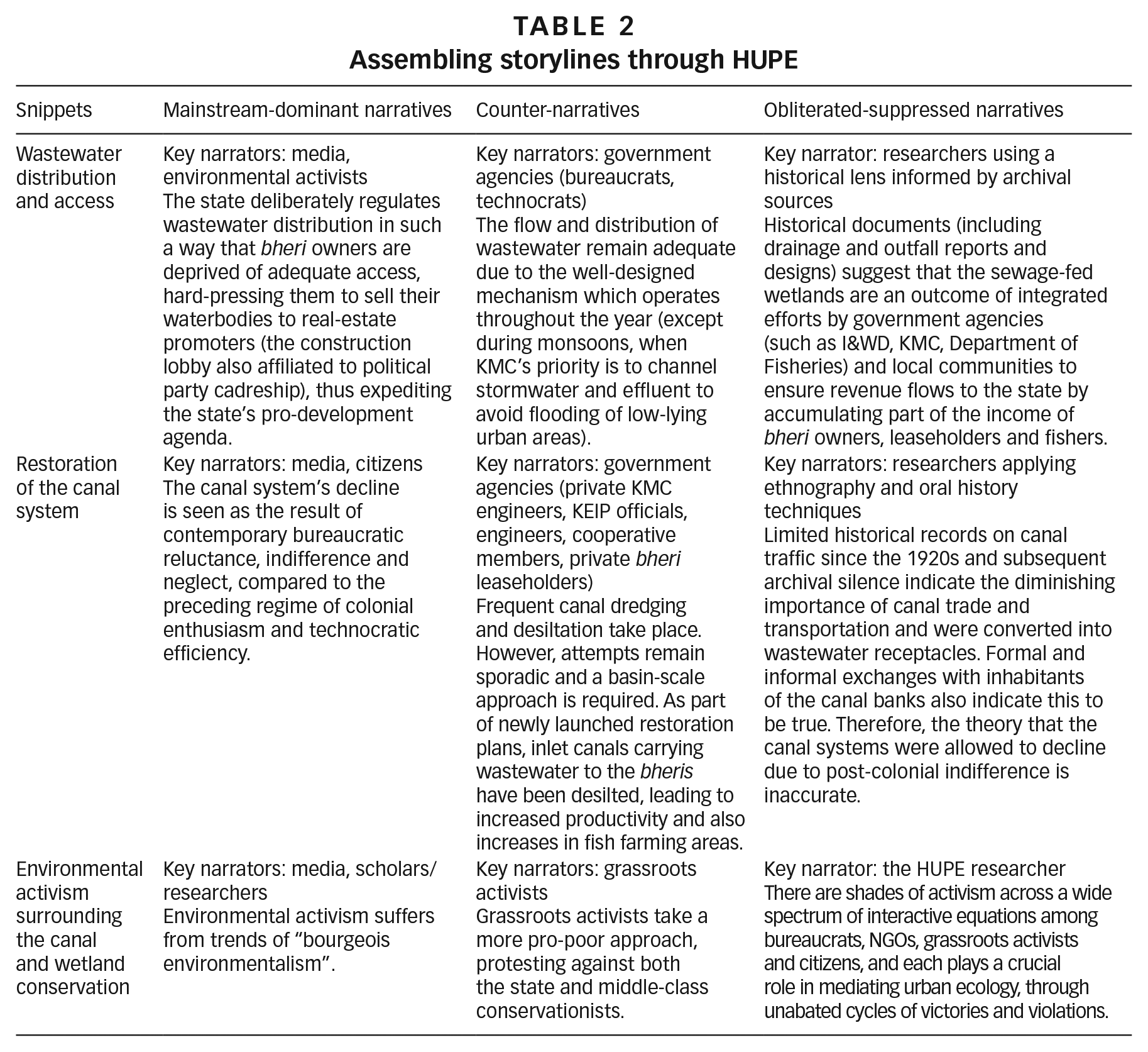
The Kolkata case study, unpacked and analysed with the application of HUPE, critically interrogates the popular narratives of post-colonial decline and “bourgeois environmentalism” that also position the state against marginalised groups, and environmental needs against development aspirations.(58) Instead, I have compiled and interpreted storylines of Kolkata’s urban ecological trajectories by triangulating information from archival sources and ethnographic research. The resulting narratives map the co-production of urban nature around Kolkata through dynamic interactions among multiple actors across different historical scales. Some snippets (Table 2) reveal collaborative potentials and possibilities within the urban environmental fabric that need to be carefully investigated and harnessed to foster urban resilience.
Assembling storylines through HUPE
To conclude, applying the concepts and methods of political ecology has enabled me to accommodate the “plural”, bringing to the fore the different collaborations, compulsions and contingencies that mediate urban ecologies. The tools of environmental history have allowed me to consider how the tensions and tussles among multiple stakeholders are shaped by past power relations, which have influenced resource allocation as well as the norms and systems that continue to influence resource allocation. Together, these explain the state of green and blue infrastructure planning and management in modern Kolkata and HUPE proves itself an enabling framework, eliciting emancipatory possibilities for more just and resilient urban ecologies of the future.
Footnotes
Acknowledgements
I would like to acknowledge that the archival access and field investigations pertaining to this research were funded through the Institute Scheme for Innovative Research and Development (ISIRD) Project (2017–2021), Sponsored Research and Industrial Consultancy, Indian Institute of Technology Kharagpur and the EU-ICSSR-sponsored EqUIP Project (2019–2022) entitled Towards a Fluid Governance: Hydrosocial Analysis of Flood Paradigms and Management Practices in Rhone and Ganges Basins (India, France and Switzerland). My heartfelt gratitude to my PhD students Raktima Ghosh and Souradip Pathak for providing technical assistance. I would like to convey my thanks to Sarah Colenbrander for offering her critical feedback on numerous versions of the draft and also thoroughly editing the final article so that it could reach a wider readership.
Correction (May 2024):
16.
Gandy (2004, ![]() ).
).
18.
21.
23.
25.
Administrative reports, revenue records and proceedings were accessed at the West Bengal State Archive, Kolkata; the Town Hall library, Kolkata; and the National Archives of India, New Delhi, including Selections from Records of Bengal Government relating to Calcutta and Eastern Canals, 1865–1904, cited in ![]() .
.
26.
Profiteering through marsh reclamation based on modern hydraulic principles is evident in the imperial mindset – “even if nothing else but mere guinea-grass were grown, the returns would be such as to secure shareholders a fair percentage on the invested capital” (Inglis, 1909, page 259).
28.
29.
32.
The East Kolkata Wetlands were named by the ecological sanitary engineer Dhrubajyoti Ghosh. He dedicated his life to understanding the socio-ecological dynamics shaping the functioning of this ecosystem.
34.
Source: personal communications (formal interviews and informal exchanges, January 2008 to December 2009) with Dr Dhrubajyoti Ghosh, who was Kolkata’s sanitation engineer and former chief environmental officer for the government of West Bengal.
38.
39.
Source: interviews conducted in January 2018 with leaseholders and fishers of different bheris.
43.
Source: interviews conducted with Gobinda Sardar (secretary); Baro Chaynavi Matsyabay Samity and Sasidulal Ghosh (leaseholders); and Jhagrashisha (private bheri owner) in November 2021.
44.
48.
To facilitate the flow of wastewater via gravity, the distribution of sewage must be maintained at a maximum Great Trigonometrical Survey (GTS) of 9 points from the Bantala lock gate that controls and regulates water distribution from the main canal. However, at the Bantala point, water is now being diverted into the outfall Kulti River after only 7.5 points of accumulation as opposed to the regulated 9, which is causing the crisis.
51.
52.
Ghosh, quoted in Sarkar (2016); ![]() page 2.
page 2.