
Abstract
African cities, faced with rapid urbanization and haphazard land use practices, struggle to address their fast-declining urban green space (UGS). Yet the spatial extent of UGS, and the influence of city planning legislation and frameworks, remains largely unexplored. Using a case study of Kumasi, Ghana, this study draws on mixed methods to address three research questions: (i) How did Kumasi’s UGS evolve from 1991 to 2019? (ii) How do city planning, legislation and the regulatory framework influence UGS management? (iii) What is the land governance institutional culture for managing UGS? Findings from the spatial analysis indicate a loss of over 80 per cent in Kumasi’s UGS between 1991 and 2019. Although unplanned urbanization, poor urban planning and political interference were frequently discussed as contributory factors, the foundational cause was found to lie in the complex and conflicting relationship between land governance agencies. This situation has resulted in the absence of a culture of coordination with regard to urban development, particularly towards UGS.
I. Introduction
The United Nations’ Sustainable Development Goal (SDG) 11 on sustainable cities and communities(1) emphasizes the importance of urban green space (UGS).(2) This is because the quest for sustainable urban development has become central in this era of increasing urbanization and a changing climate, with their accompanying socioeconomic and human health challenges. The World Health Organization(3) describes UGS as providing key ecological and health functions in many urban agglomerations, including regulating climate conditions, improving air quality, promoting biodiversity and enhancing flood control. Emerging global literature(4) shows that the discourse on UGS in urban ecosystems has been broadened under the blue-green infrastructure framework, an approach to developing resilience to urban flooding that takes advantage of UGS and naturalized water flows.
Yet most urban development in Africa continues to occur without consideration of UGS,(5) despite recent cases of a policy focus on integrating green spaces into city planning and design. For instance, Zakka et al.(6) indicate that in Northern Nigeria, the masterplans of Abuja and Zaria made provisions for green spaces, including natural rock outcrops, open space, parks and monuments. Related cases are discussed for elsewhere in Africa, including South Africa(7) and Ghana.(8) However, evidence on the ground suggests a more general dearth of attention to UGS. As the demand for urban land increases, UGS is ignored, rezoned, or encroached upon by urban planners and residents to provide space for land uses with greater economic benefits, such as commercial, residential and industrial uses.(9) In South Africa, no more than 10 per cent of the land extent of most towns consists of green space.(10) Similar findings are reported in Ghanaian cities.(11) Meanwhile, evidence from cities like Singapore suggests that rapid urban development can coexist with UGS,(12) but this coexistence depends on effective planning and management frameworks, which unfortunately are lacking in most African cities.(13)
The current state of UGS in Africa raises concerns about land governance(14) in terms of legislative regulatory frameworks(15) and institutions in place for managing UGS. These frameworks and institutions of urban planning and management are expected to be proactive and responsive to the needs of residents,(16) and remain critical in UGS provision and management. However, the condition of UGS in Africa demonstrates an incoherence in land governance. Although there is some significant literature on UGS in Africa,(17) none of it has examined how land governance – legislative regulatory frameworks and institutions – affects UGS management.
This paper addresses three research objectives:
(i) To map the spatio-temporal evolution of UGS in Kumasi from 1991 to 2019;
(ii) To examine the influence of city planning, legislation and the regulatory framework on UGS management; and
(iii) To assess the institutional culture(18) of land governance for managing UGS in Kumasi.
The research draws on insights from urban political ecology (UPE) to advance our understanding of the provision and management of UGS, and how land use–planning relations unfold in African cities. UPE is a theoretical framework that argues that power relations and other socio-political factors trigger the provision and management of urban spaces.(19) The theory engages with the growth of cities by explaining the relationships between social, economic, and cultural power interactions and the physical environment and how they shape urban planning and management patterns.(20) Literature on UPE suggests that rapid urban growth continues to feature significantly in UGS discourse as an important lens to uncover more broadly the complex relationships among urban land management, sustainability and resilience.(21) Our interest in UPE in this study is thus predicated on its utility in explaining how UGS is planned and managed through socioeconomic and ecological processes; and how urgent it is to focus on the foundational political processes involved in the relationship among urban growth, land use planning and UGS management.(22)
By using the UPE framework, we aim to examine how access to, and the control and use of, urban land(23) contributes to UGS decline amid rapid urbanization. UGS has evolved in design and function to reflect changing societal needs and priorities. Historically, UGS has been used to address such societal challenges as city overcrowding,(24) loss of nature,(25) post-industrial degradation,(26) interpersonal disconnections(27) and spatial injustice.(28) Presently, the understanding of UGS has evolved in complexity, justified not only on civic, recreational or environmental grounds, but as a key component for urban sustainability(29) and for tackling climate-related vulnerabilities such as flooding.(30)
Insights from UPE help to illuminate two critical issues in this study. First, UPE provides a context for evaluating UGS as a combination of public and private green areas that provide a critical variety of ecological services, including cultural, aesthetic, environmental and socioeconomic aspects of urban living.(31) Second, the UPE framework relates land governance to institutional decision-making structures and processes for land access and use, and for the enforcement and handling of conflicting land interests.(32) Given that land governance affects the uses to which land is put, it can be leveraged to offer solutions to the challenges confronting UGS. This study explores this understanding of the relationship between UGS management and land governance.
This research contributes to UGS literature in three main ways: (i) it explores through a UPE lens how a lack of collaboration between various land governance institutions is a recipe for poor UGS management in African cities; (ii) it provides case study evidence on the roles of and links between land governance and UGS management; and (iii) it offers insights into the urgency of an integrated approach to UGS management in African cities.
This paper has five parts. After this introduction, Section II presents the study setting and the research approach used. Section III presents and analyses the findings of the research. Section IV provides a critical discussion of the results. Section V presents concluding remarks.
II. Study Area and Research Methods
a. Study setting
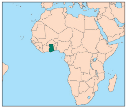
The research focuses on the metropolis of Kumasi, the capital of the Ashanti Region and the second largest city in Ghana (Map 1). In 2012, the Kumasi metropolis comprised nine sub-metropolitan areas.(33) However, in 2018, five new municipalities were created out of the metropolis, confining the main city to a small geographical space despite its widespread influence. For this research, the state of the metropolis as of 2012, when it consisted of the nine sub-metropolitan areas, is used because of the availability of data and the contiguous nature at that point of green space across the city’s landscape.
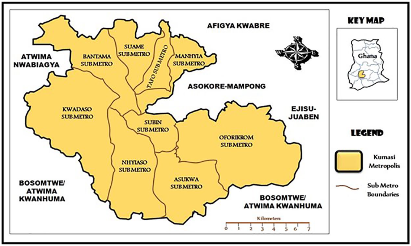
Kumasi metropolis
The city falls within the tropical forest region, with an average minimum temperature of 21.5°C and an average maximum temperature of 30.7°C.(34) It experiences two yearly peaks in rainfall, from March to July and from September to October. In agroecological terms, the city lies within Ghana’s semi-deciduous South-East Ecological Zone.
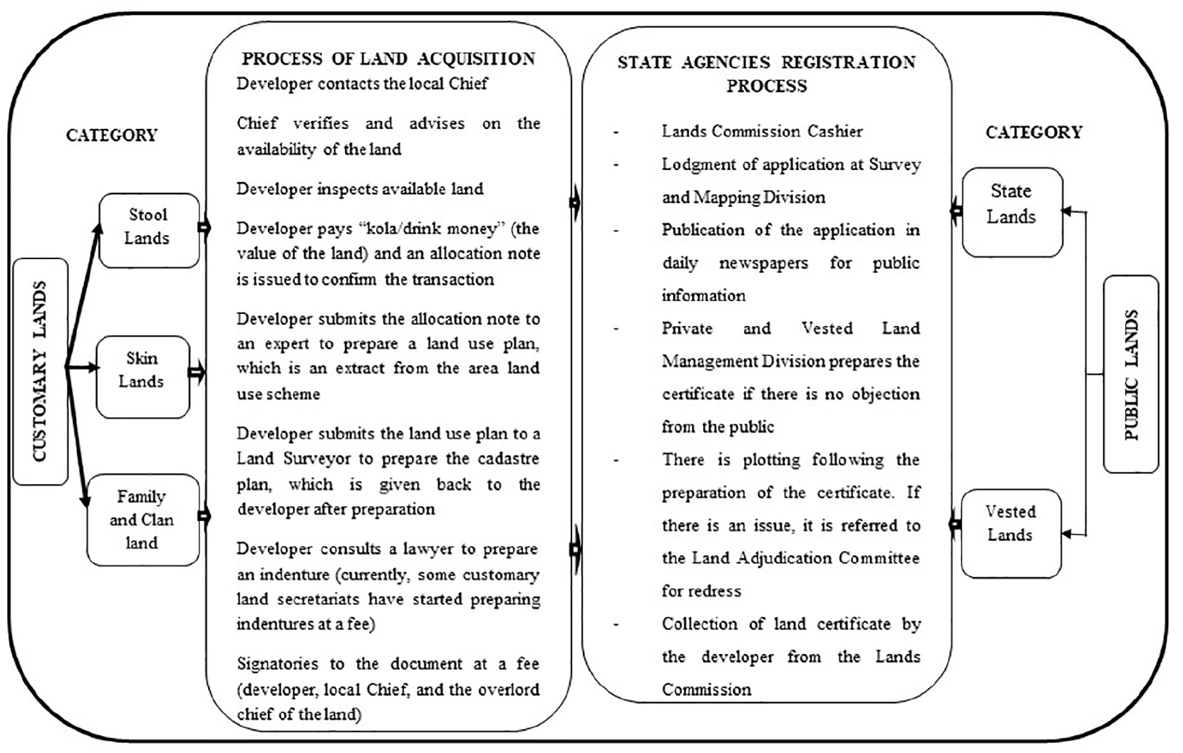
With a population of about 1.7 million, Kumasi accommodates a considerable proportion of the total populace in the Ashanti Region (population of 4.8 million) on 214 square kilometres of land.(35) Kumasi’s total area, however, represents only 0.9 per cent of the Ashanti Region’s land. The high concentration of people within the city has resulted in rapid development there, even spreading to adjoining districts.(36) With an average annual population growth of over 5 per cent since 2000,(37) and an annual rate of expansion of 3.5 per cent between 1986 and 2018,(38) city authorities are confronted with formidable planning and management challenges, including housing inadequacy, haphazard urban development, and the need for informal settlement development and social amenities.(39) A particular land governance concern is the continuous loss of UGS. Kasim Kasanga has written extensively on land governance in Kumasi and Ghana in general,(40) and this subsection draws insights from these studies and other current research to demonstrate the critical nature of land governance in UGS management. Land governance in Ghana reflects a unique mix of statutory and customary arrangements that coexist in claiming authority and rights over land.(41) This form of land governance is popularly referred to as dual governance. The traditional authorities(42) act in parallel with state structures to determine rules, regulations and obligations governing interest in land, ownership of rights and land use.(43)
As with any city in Ghana, the dual land governance practice in Kumasi has arguably affected land management, and for Kumasi specifically, the successful continuation of the colonial garden city plan. Historically the British used the built environment to express their colonizing power and control, in this case over the people of Kumasi (Asantes), by rebuilding the city based on European design features. This process marked the beginning of a change in Kumasi’s morphology from a traditional capital to a colonial city developed for European habitation. Kumasi was rebuilt according to principles drawn from a 1945 garden city physical plan designed by Maxwell Fry and Jane Drew. Substantial provisions were made for UGS, with a green belt 300 yards wide surrounding the central city,(44) and several other green spaces including Kumasi Zoological Gardens, Kejetia Park, Suntreso Park, Suame Park, Amakrom Park and Fante Newtown Park. Kumasi was known as the Garden City of West Africa. Korboe and Tipple(45) assert that: “. . .Kumasi was a very attractive city indeed. Large parts of the city were now covered in lush vegetation (of colourful flamboyants, various shrubs, and well-tended grass lawns). It was indeed a city of which the people of the newly independent nation were proud.”
Even after independence in the late 1950s, Kumasi’s 1945 plan was continuously referred to by successive regimes. Another attempt was made to consolidate Kumasi’s garden city legacy through a 1963–1988 plan that increased UGS coverage in the city, allocating 20,000 hectares of land for agricultural and other UGS development. Since then, not much has been achieved in the direction of UGS provision and management, despite the implementation of several UGS projects (e.g. Kumasi Beautification Project) and operations of UGS institutions (Department of Parks and Gardens, Environmental Protection Agency, Kumasi Metropolitan Assembly, etc.). The UGS (Table 1) that dates back to the days of Kumasi’s garden city prominence have been encroached upon, changed into different land uses or poorly maintained. A study by Owusu-Ansah(46) on 19 colonial urban green spaces reveals that only six of them are currently being used for their intended purposes, while the rest have been partially or wholly encroached upon by retail stalls, transport terminals and other informal activities.
Status of green spaces in Kumasi

As shown in Figure 1, the dual land governance division in Ghana, between public lands and customary lands, is divided further into state/vested, family/clan and stool/skin lands.(47) The two broad categories of public and customary land have their institutional establishments and procedures for land administration and are required to work cooperatively. Given the continued existence of supportive legislation, regulatory frameworks and institutions, one would expect strong land governance practices in place to manage Kumasi’s green spaces. On the contrary, as of the end of 2019 considerable UGS had disappeared from Kumasi, and the aesthetic draw of the city has greatly declined.(48)
Land governance structure in Ghana
Kumasi was selected for this research: (1) because it is the only city in West Africa that was historically characterized as a garden city;(49) (2) because of the socio-political power conflict over the management of UGS between state agencies and traditional authorities;(50) and (3) because of the evidence of UGS decline, rapid urbanization and an unresponsive urban planning regime.(51)
b. Research methods
A mixed-methods approach was adopted for this study. This included a review of secondary data, the use of the Normalized Difference Vegetation Index (NDVI) to assess changes in vegetation coverage, and interviews with the staff of key agencies. The secondary data review focused on over 20 relevant local studies on the topic, published as journal articles, books and conference proceedings.(52) The secondary data review further examined six local government and planning documents, including the 2016 Land Use and Spatial Planning Act and the Local Governance Act, 2016 (Act 936), the Kumasi Metropolitan Assembly (KMA) Medium Term Development Plans (2014-2017; 2018-2021),(53) the KMA residential categorization (Kumasi Metropolitan Assembly, 2019)(54) and the Kumasi Beautification Project report.(55)
The secondary data review was useful in identifying the key institutions and actors involved in land governance and the provision and management of UGS in Ghana. It also served as the basis for choosing Kumasi as the case study for this research and selecting relevant agencies for the data collection. For instance, the review showed that the poor maintenance culture, uncooperative attitudes of urban residents, land tenure challenges, low priority accorded to green spaces, and weak enforcement of development control regimes, all characterizing poor management of UGS, have their foundation in the prevailing land governance practice. Based on this, the present study addresses land governance practice – legislation, the regulatory framework and institutions – in UGS management from the perspective of both government agencies and traditional authorities.
To address the study’s objective of mapping the spatio-temporal evolution of UGS, NDVI was used. Several studies on UGS(56) assess the change in the coverage of green space using NDVI. NDVI is a technique that employs a specific formula – (Near Infrared - Red) / (Near Infrared + Red) – to measure the characteristics of vegetation through remotely sensed data. NDVI values range from –1 to +1. Values close to +1 signify active vegetation, which includes nature reserves, farmlands and forests. Values less than 0.1 have low to no presence of vegetation, and include built-up areas. In this study, the NDVI values were calculated using the raster calculator command in ArcMap 10.6 in ArcGIS. The spatial classification of UGS in this paper is based on the definition of UGS as land partly or totally enveloped with greeneries (e.g. grass, trees or other vegetation), including parks, urban forest, community playgrounds, gardens, undeveloped green areas, and nature reserves.(57)
First, the Ghana district shapefile data were obtained from https://www.rsgislab.ug.edu.gh and used to extract the area of interest, KMA. The KMA shapefile was overlaid on the Landsat images to establish a boundary of the study area. The Landsat satellite images [Thematic Mapper (TM) 1990, Enhanced Thematic Mapper (ETM+) 2000, Landsat 8 Operationalized Landsat Imager/Thermal Infrared Sensor (OLIS/TIRS) 2010, and ASTER GLOBAL Digital Elevation Model (DEM) 2019] for Kumasi were acquired during Ghana’s rainy season, to ensure that all green spaces were not negatively impacted by dry weather conditions. The Landsat images were acquired from the USGS database with 194 and 55 as the path and row scene, with geometric correction to the WGS 1985 UTM Zone 30N coordinate system. The images had a spatial resolution of 30 metres; while this level of resolution is not ideal, other studies have effectively used such images to examine changes in urban land use and land cover.(58) The images’ multispectral bands capture data on vegetation, water features and bare areas. They are sufficient for analysing changes in urban land use and cover at the city scale.(59) To improve the image clarity, all satellite images were downloaded with a cloud cover limit below 10 per cent. This process has been summarized in Figure 2. The NDVI (Formula 1) was calculated using Band 3 (Near Infrared) and Band 4 (Red) because the satellite images were obtained from Landsat 4-7. Table S1 (in the online supplement) presents the NDVI values for the three major vegetation cover types identified in Kumasi. These are tree canopy cover (such as urban forest), irrigated grass cover (such as parks, gardens and nature reserves) and non-irrigated grass cover (including undeveloped green areas).

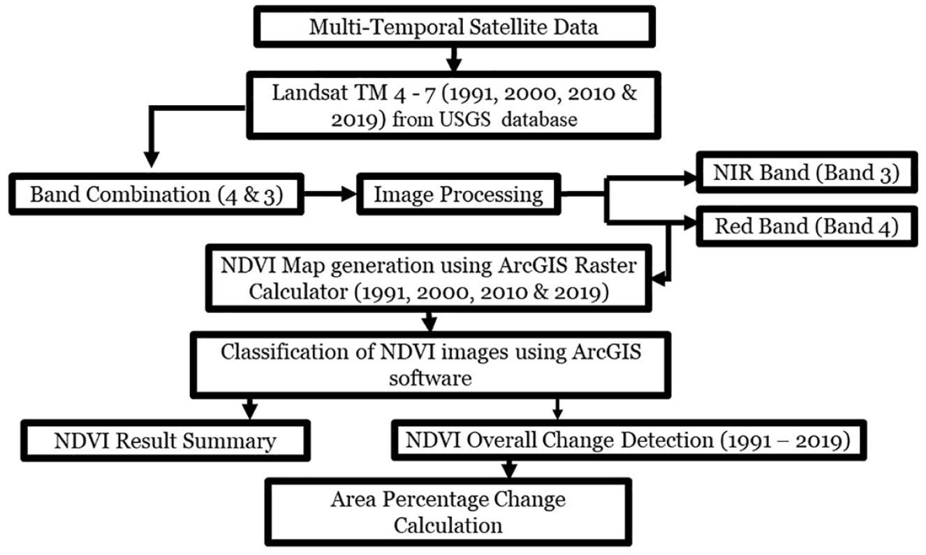
Flow chart for NDVI calculation
To address study objectives two and three (the influence of city planning legislation and frameworks on UGS management and the land governance institutional culture for managing UGS), semi-structured agency interviews were used. As presented in Table S2 (in the online supplement), 12 agency respondents, including six government agency officials and six representatives of the traditional authorities, were involved in this study. The six selected institutions were the Kumasi Metropolitan Assembly (KMA), the primary authority for planning and development; the Physical Planning Department, in charge of delineating areas for UGS; the Department of Parks and Gardens, in charge of landscape beautification, development and management; the Environmental Protection Agency, responsible for environmental protection; the Regional Lands Commission Kumasi, which manages public land; and the Development Control Unit, which performs development control functions. In addition, representatives of traditional authorities in six suburbs across the city – Manhyia, Kwadaso, Atasomanso, Ayigya, Old Tafo and Amakom – were interviewed in order to understand their role and influence in UGS management, considering that they serve as guardians of about 80 per cent of Kumasi’s land. The interviews focused on four thematic areas: UGS design and management challenges; the condition of UGS; the influence of city planning legislation and frameworks on UGS; and institutional initiatives towards managing UGS.
The interviews were conducted in June 2019 and allowed ample flexibility to engage with the responsible staff from various institutions while still addressing the thematic focus of the data collection.(60) The interviews were conducted on weekdays during working hours, mostly at the offices of the institutional respondents, and lasted between 45 and 60 minutes. The NVIVO 10 software package was used to determine categories and code the interview data. Content analysis was both inductive and deductive. Interview content on issues such as the institutional responses, collaboration and coordination led to inductively developed codes, whereas categories such as the drivers/causes of poor conditions of UGS were deductively generated based on the review of the secondary data. However, mindful of the discrepancies that might result during data analysis,(61) the codes and categories were further merged and refined to produce conceptual groupings using common associations. This process increased our understanding of the whole body of data, as the respondents’ perceptions of UGS and land governance were reflected in the final categories. For example, findings from the institutions and traditional authorities were cross-referenced to examine institutional collaborations and interrelations among UGS institutions. Cobbinah et al.(62) indicate that this process is useful to identify and address any inconsistencies that emerge during the data analysis process.
III. Results
a. Urban morphology in Kumasi: spatio-temporal analysis of UGS
Table S3 (in the online supplement) summarizes the NDVI values from 1991 to 2019 over a land area of 21,431 hectares. Based on the NDVI values in Table S3, the UGS cover in Kumasi has declined rapidly, mostly having been converted into built-up development, including buildings and roads. Over a period of three decades (1991 to 2019), the NDVI value for vegetation cover (tree canopy cover, irrigated and non-irrigated grass cover) in the city declined from 0.4 to 0.1, representing a reduction of about 88.42 per cent in UGS cover. Within the NDVI value range of 0.1 to 1.0, indicating varying degrees of vegetation cover,(63) Kumasi’s NDVI value of 0.1 as of 2019 indicates limited UGS. A comparison of the NDVI images in Figure 3, as well as their associated land use changes in hectares (Table 2), allows for a graphic appreciation of the rate of vegetation cover decline.
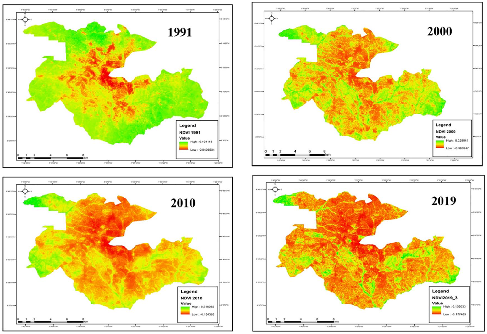
Spatio-temporal evolution of UGS in Kumasi (1991–2019)
Changes in land use and land cover (in hectares) and population in Kumasi (1991–2019)
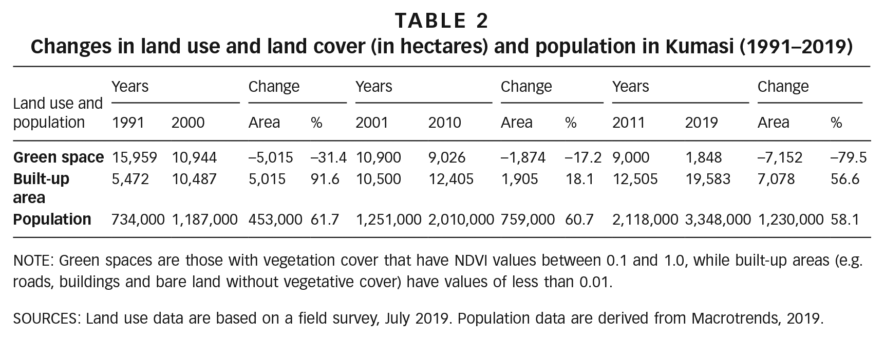
NOTE: Green spaces are those with vegetation cover that have NDVI values between 0.1 and 1.0, while built-up areas (e.g. roads, buildings and bare land without vegetative cover) have values of less than 0.01.
SOURCES: Land use data are based on a field survey, July 2019. Population data are derived from Macrotrends, 2019.
Table 2 shows that over a 28-year period, Kumasi has experienced 88.42 per cent reduction in UGS. The periods 1991–2000 and 2011–2019 registered the highest reductions in UGS: 31.4 per cent and 79.5 per cent respectively, which translates to an expansion of the built-up area by 91.6 per cent and 56.6 per cent for the same periods, respectively. This change in Kumasi’s morphology has been influenced by the administrative and economic structure of the city, which has pulled people to the city. This lends further credence to the UPE characterization of control, access and use of urban land(64) as fundamental determinants of the state of UGS. The city’s central location as a commercial hub, with major thoroughfares to all parts of Ghana, has led to an influx of population from various parts of the country into Kumasi. Unsurprisingly, Kumasi has recorded a yearly growth rate in population of over 5 per cent since 2000. As illustrated in Table 2, losses in green spaces have been traded for development in the built-up areas. In explaining the lack of action in response to this trend, an official at the Physical Planning Department revealed that: “the preparation of Kumasi’s 1945 garden city plan accompanied by the imposition of English land governance legislations such as Kumasi Lands Ordinance (1943), Local Government Ordinance of 1951 and Native Administration Ordinance (1927) . . . led to the development and protection of UGS in and around the city for colonial interest. These conscious efforts by the British commemorated Kumasi’s success as a garden city.” (Physical Planning Department official, June 2019)
The interview data show that the rapid loss of UGS in Kumasi reflects the socio-political land governance rivalry between traditional authorities and government agencies. The UPE approach considers this rivalry as resulting mostly from control, access and use of land.(65) In fact, a major factor remains poor coordination between traditional authorities and state agencies. For instance, an interview with the Physical Planning Department official suggests that traditional authorities often allocate and sell land without prior approval from government agencies: “We [Physical Planning Department] have well-designed planning scheme for almost all urban communities in Kumasi. However, most of the traditional authorities sell land without consulting us. They work with informal surveyors to demarcate and lease land . . .that is why development on the ground is different from our plans.” (Physical Planning Department official, June 2019)
As this official indicates, state institutions are unable to ensure provisions for UGS in land use schemes as they are rendered powerless by traditional authorities over the control of green spaces. Representatives of the traditional authorities, however, disagreed with this claim, indicating that state institutions are unable to manage the UGS because of their lack of recognition and respect for the traditional authorities: “They [government institutions] think they have power to determine how land in this community should be used, forgetting that we are the traditional owners and custodian of the land . . . You can’t disrespect us and exercise control over our land. That can never happen.” (Traditional authority representative Atasomanso, June 2019)
As indicated here, the conflicting land governance roles of government agencies and traditional authorities have consequences for UGS management. Further complicating the capacity of government agencies to effectively regulate physical development are limited resources, political interference and corruption: “All those building along the stream [nature reserve] here [Manhyia community] have permits from the government agencies because they [owners/developers] are politicians or know someone who has political influence. Some also make huge payments to have their ways. . . And when we [traditional authority] talk about it, they [government agencies] say we are part of the problem. . .” (Traditional authority representative Manhyia, June 2019)
While the majority of the interviewed government agency officials (five out of six) admit that there are some cases of corruption and bias associated with their activities (e.g. development permit issuance) in the state institutions, they maintain that the traditional authorities facilitate poor land development and the destruction of nature and pristine areas (e.g. water resources). Unfortunately, this situation has resulted in uncontrolled and haphazard urban development and the encroachment of UGS across the cityscape. As shown in Table 2, a reduction in UGS is associated with an upsurge in the built-up area. For example, between 1991 and 2000, there was a 5,015-hectare reduction in UGS and a corresponding increase in the built-up area. Similar changes were identified for the other periods (i.e. 2000–2010 and 2011–2019). An agency interview revealed that: “. . .Encroachers have less regard for green spaces and often ignore attempts by the Development Control Unit to regulate development. The government agencies are unable to follow up with actions against nonchalant developers because we have low institutional capacity in the form of limited personnel, finance, and logistics.” (Development Control Unit, June 2019)
As of 2019, out of a total land area of 21,431 hectares, Kumasi has only about 1,848 hectares of UGS, or 8.6 per cent. The secondary data review (Table 1) and the spatio-temporal analysis (Figure 4) indicated that the major remaining UGS is mostly under institutional control, including by the Kwame Nkrumah University of Science and Technology (KNUST), Kwadaso Agriculture College, Baba Yara Sports Stadium, some areas within the Adum (Central Business District) area (Rattray Park, Kumasi Golf Course, Kumasi Zoological Garden and Ridge areas), and the Barekese Dam buffer.
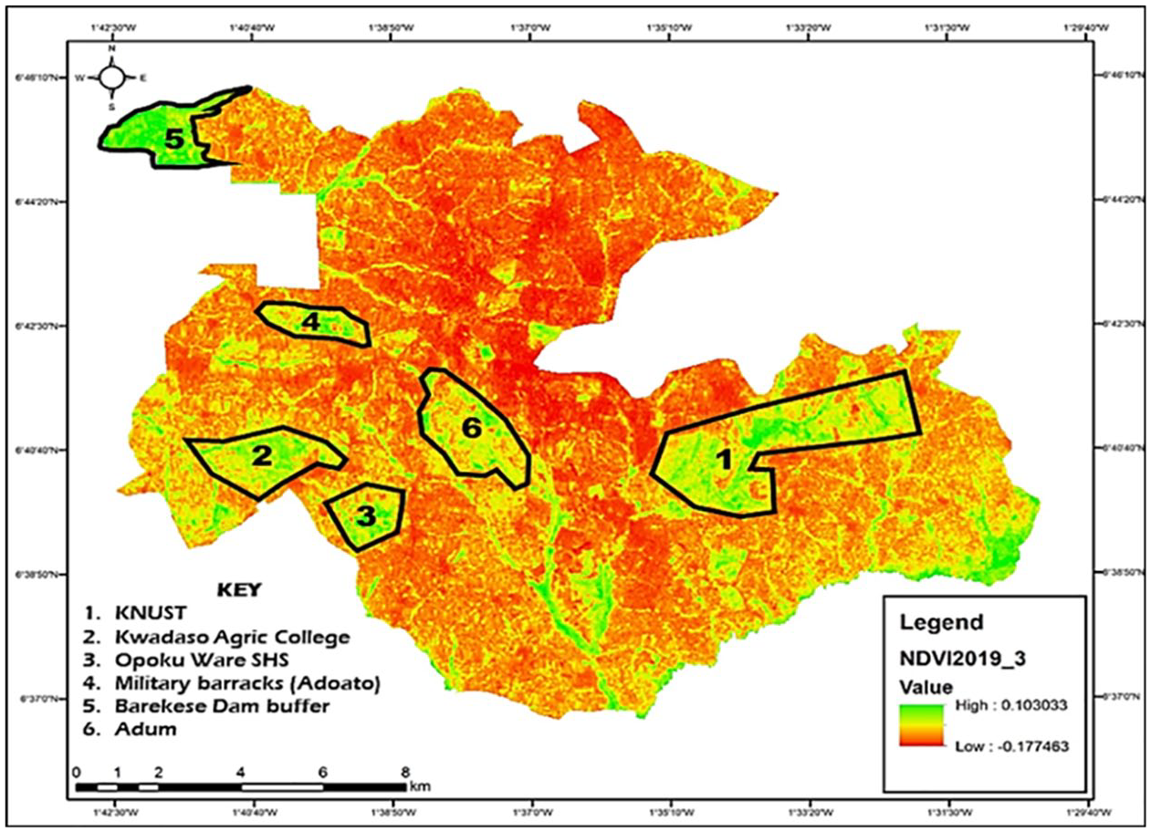
Major remaining UGS in Kumasi
The urban political ecology of UGS in the city of Kumasi is challenged by the lack of agreement among the key agencies on the access to, and control and use of, these important urban spaces. This rivalry between state agencies and traditional authorities hinders the capacity for UGS to provide the ideal variety of ecological services, thereby affecting the cultural, aesthetic, environmental and socioeconomic aspects of urban living.(66) This situation has implications for the UGS management regime, as discussed in Section IIIb.
b. UGS management in Kumasi: legislation and framework
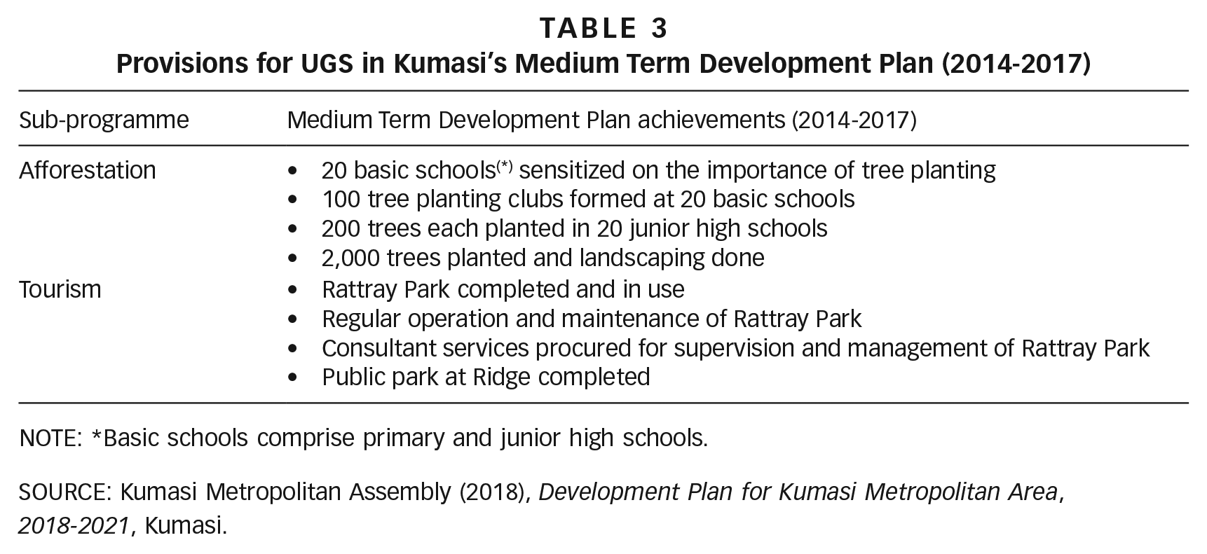
As discussed in Section IIa, land governance practices in Ghana manifest principally in three forms: legislation, the regulatory framework and institutions. Findings from the agency interviews and secondary data review show that the Local Governance Act of Ghana, 2016 is the only major legislation at the city level that mandates Ghanaian city authorities to act as the principal authority for the planning and control of spatial development, including UGS. An interview with the KMA development officer revealed that the KMA does not develop specific green space designs and strategies, even though its current Medium Term Development Plan (MTDP 2018-2021) recognizes declining vegetation cover as a key development issue. To address this issue, the objective of the MTDP (2018-2021) is to “combat deforestation, desertification and soil erosion” by improving motivation to act, along with other strategies to inspire operators of environmental resources to use limited exploitative and non-destructive approaches in farming.(67) As outlined in Table 3, the MTDP 2014-2017 also had strategies to reverse forest and land degradation.
Provisions for UGS in Kumasi’s Medium Term Development Plan (2014-2017)
NOTE: *Basic schools comprise primary and junior high schools.
SOURCE: Kumasi Metropolitan Assembly (2018), Development Plan for Kumasi Metropolitan Area,
2018-2021, Kumasi.
However, these medium-term development plans (2014-2017 and 2018-2021) show only marginal incorporation of UGS concerns, with no clear regulatory framework or guidelines for managing UGS. Rather, strategies focus mainly on planting trees, with little attention to the overall management of UGS. The development planning official from KMA explained: “We do not have any specific framework available for managing green spaces in Kumasi. The assembly protects those areas [designated green spaces] so that we don’t change their uses . . . so we [the assembly] focus on tree planting in schools, our communities and along major roads.” (KMA official, June 2019)
This statement indicates that the city authorities are more focused on increasing the number of trees than on managing UGS as a critical force for urban socioeconomic and environmental development. Even with these planting efforts, the city authorities are still unable to protect the “designated” UGS. The KMA development officer admitted that: “. . .inasmuch as we are protecting urban green spaces, sometimes we have to reclaim the land [designated green spaces] for other land uses. We all know the era in which we are [urbanization], the land is scarce, and everyone needs land for certain things. . .” (KMA official, June 2019)
The UPE focus is on linking land governance to institutional decision-making structures and processes on land access and use. But with no regulatory framework, enforcement and conflict resolution are hampered.(68) In this sense, it was unsurprising that the interview data showed a low prioritization of green spaces in the city’s development agenda, given the degree of competition with other “pressing” development concerns such as waste management, transportation, energy, water management and education. However, interviews with all six traditional authority representatives indicated that they do have a framework that guarantees the protection and management of UGS: “We have traditional customs such as recognizing nature reserves, sacred groves and water bodies as gods, and this prevents people from encroaching and developing into those areas. But the government officials think that they know better, and often go against our decisions . . .” (Traditional authority representative Atasomanso, June 2019)
As indicated here by this representative, while traditional land governance practices may be useful in protecting UGS, they are largely unofficial or unrecognized by the government agencies. This finding is consistent with previous research reporting the unofficial dominance of traditional authorities in land use planning.(69) The lack of recognition means these practices are not enforced; meanwhile the state agencies’ responses are ineffective in addressing UGS management problems. It is worth acknowledging that traditional practices and norms are well known, but this does not automatically lead to their enforcement and observance. In fact, research(70) shows that traditional authorities are often primary contributors to the depletion of UGS through indiscriminate land leasing and non-adherence to planning requirements. As discussed in Section I, the strength of the UPE approach is the context it provides to leverage land governance prospects via stronger structures and collaboration.(71) This could offer solutions to the challenges confronting UGS.
c. Land governance institutional culture in UGS management
Lessons from UPE emphasize the centrality of access to and control and use of urban land, consistent with the governance structures(72) in determining the condition of UGS. This subsection presents an analysis of the institutional culture of land governance in Kumasi to contribute to a better understanding of UGS management. Although the KMA is established as the overall management agency in Kumasi, the institutional interviews revealed that the management of green spaces is also affected by the activities of other local government departments and agencies, including the Physical Planning Department, Department of Parks and Gardens, Development Control Unit, Regional Lands Commission Kumasi and Environmental Protection Agency. Unfortunately, their activities are uncoordinated. The Physical Planning Department official mentioned that, although the agency had demarcated several green spaces in its land use plans/schemes, the Department of Parks and Gardens has failed to plan and develop the necessary landscape and floral beautification. Meanwhile, the Department of Parks and Gardens official indicated that they lacked the equipment and skilled personnel to provide the necessary landscape and management services. Officials from the Development Control Unit and Regional Lands Commission Kumasi also pointed to the need for coordination: “. . .We [the Works Department] have carried out several eviction exercises to sack people encroaching on urban green spaces. However, we realized that the people [encroachers] always return because those areas [urban green spaces] are mostly undeveloped and are considered by encroachers as vacant lands. What else can we do? We can’t be going for inspections every day. . .” (Development Control Unit official, June 2019) “. . .sometimes, designated urban green spaces are changed to suit the use of residents applying for a lease. If town planning [the Physical Planning Department] with all its expertise decided that it is now okay [to change use], we will go with them because it’s their mandate. . .” (Representative of the Regional Lands Commission Kumasi, June 2019)
Other institutional representatives (e.g. from the Department of Parks and Gardens and the Environmental Protection Agency) attributed the lack of coordination to “institutional plurality” in UGS management, whereby each department or agency is intended to have special expertise in some aspect of the management process, but without collaboration. The Physical Planning Department official explained that – except for the Department of Parks and Gardens, which is primarily in charge of landscape beautification – the additional responsibilities of other government departments often overshadow urban green development and planning. Even when one department effectively executes its responsibility with regard to green spaces, positive outcomes may be undermined by the negligence or limited efforts of the other departments.
The traditional authorities, which control 80 per cent of the city’s total land, have taken the brunt of the blame for leasing UGS for other development purposes (e.g. commercial and residential uses). However, interviews with their representatives show their stated commitment to protecting green spaces. According to these representatives, their presence in the city allows them to keep constant oversight over UGS to ensure its protection from encroachment. They do, however, admit that preserving stool lands for green space is often left to their discretion since they are not aware of standards for green space provision. A secondary analysis of Ghana’s planning standards and zoning guidelines by the Town and Country Planning Department(73) reveals that available standards for open spaces only pertain to the size of the populations served. For instance, one durbar ground,(74) with an area of 0.2 hectares to 1 hectare, is supposed to be provided in any area with a population of at least 35,000.
The consensus among the traditional authorities’ representatives was that encroachment on green spaces in Kumasi has been aided by the unauthorized sale of lands and weak administration by state regulatory institutions. A representative of the Ayigya traditional authority remarked that: “. . .not everyone buys their land from the chiefs. Even without having the right papers [allocation note] from the chiefs, some people have permits to develop the land. This is because they find a devious way of working things out with the government institutions in charge. . .” (Traditional authority representative Atasomanso, June 2019)
Analysis of the agency interviews indicates that the existing friction between traditional authorities and state regulatory institutions on the state of UGS on stool lands would be nonexistent if UGS were regarded as public lands (Section II) by Ghana’s Constitution. The official from the Regional Lands Commission Kumasi explained that classifying green space as public lands would give the Regional Lands Commission Kumasi the mandate to exercise the legislative power of eminent domain, which allows stool land to be acquired from the traditional authorities, and to be designated for UGS for community interest. The Regional Lands Commission Kumasi official commented: “. . .Since green spaces are developed on stool lands, we [the Regional Lands Commission Kumasi] can’t question chiefs on why green spaces haven’t been allocated. We are not landlords. However, if such lands are acquired by the assembly as public lands, prior stool rights can be relinquished, and management transferred to Lands Commission on behalf of the government.” (Representative of the Regional Lands Commission Kumasi, June 2019)
The current administrative rivalry is fuelled by the overlapping claim to green spaces, whether as stool land by traditional authorities or as public land for the public good by the state agencies. Addressing these institutional gaps, using insights from UPE, is key in facilitating the effective management of UGS.
IV. Discussion
This research demonstrates that UGS management is an extremely difficult part of city planning and management in Kumasi, as in Africa as a whole. It is reasonable to contend that unplanned urbanization, increasing demand for housing and land, political interference, and limited provision of social services in Kumasi are in themselves foundational causes of poor UGS management. While this may be true to some extent, many researchers(75) have explained that convoluted processes of land governance, involving the uncoordinated activities of government agencies and traditional authorities, have limited the capacity to address emerging urban development issues, particularly UGS depletion. Kumasi, in effect, is deficient in the kind of collaborative land governance practices that could effectively support an urban political ecology emphasizing planning, promoting collaboration and coordination, addressing urban development problems and advancing resilient and functional futures.
Most particularly, however, this research recognizes the effect of land governance in terms of management regimes on the political economy of UGS in Kumasi. Land governance institutions – both government and traditional – provide important cultural, social, economic and sometimes environmental frameworks for city residents to maintain their culture by revering and following traditional authorities’ protocols, while adhering to government institutions’ requirements on land management. Yet the increasingly wide gap between these institutions results in UGS management worries, paradoxes and clashes in Kumasi. First, land governance challenges have contributed significantly to UGS decline in Kumasi. Over 80 per cent of UGS has been lost in less than three decades. Second, city planning and management institutions seem to have abandoned UGS management. Due to rapid urbanization in Kumasi, physical development has dominated, and there is no administrative or policy framework for managing UGS. Third, there is a striking gap between the present state of UGS in Kumasi and the roles played by the management institutions, suggesting that these roles are merely conceptual and find no expression in space.
The focus of this research differs from that of a number of past works on UGS in many Southern cities in that it has drawn on UPE to analyse land governance experiences and their influence on UGS management. However, it also lends credence to more general findings that UGS in developing countries is rapidly declining,(76) and that its management and sustainability are influenced by land management systems.(77) UGS is affected by urbanization and climate change,(78) but also by the socio-political power relations that lead to conversion of, and encroachment on, UGS.(79)
A number of studies have pointed to the association of UGS decline with increasing urban development.(80) Consistent with those research findings, this study, through its spatio-temporal analysis, has shown how much UGS in Kumasi is lost to development (Table 2 and Figure 3), despite the well-established importance of UGS in providing sustainable, resilient and functional urban futures.(81) Emerging literature indicates, in fact, that the centrality of UGS in the urban ecosystem has led to the understanding of blue-green infrastructure as a more nature-friendly framework for addressing urban flood risk in cities across the world,(82) and to a recognition that the success of blue-green infrastructure depends on the management of UGS and naturalized water flows. Adedeji and Fadamiro(83) have already signalled the negative outcomes (e.g. increased pollution) of poor UGS management in Southern cities.
In essays on UGS, the production of functional and sustainable urban systems that balance environmental, economic and social aspects of urban living remains hotly debated.(84) The institutional interviews in this study showed that the absence of frameworks for UGS management is aggravated by a lack of coordination both between the city’s land management agencies, and between government agencies and traditional authorities. In the context of rapid and unplanned urbanization, the production of sustainable, resilient, functional urban spaces cannot be realized in the absence of such cooperation, which will also affect more adverse and complex urban challenges such as pollution, flooding and informal settlement formation in the future.
This study demonstrates that adequate attention to UGS on the part of land governance agencies presents an opportunity to spur the recovery and improve the management of UGS in Kumasi and beyond. Unfortunately, the obstacles detailed here make the creation of a sustainable, resilient and functional city a distant hope in Kumasi. Conflict within land governance institutions is clearly not the sole cause of UGS decline in Kumasi. As discussed in Section I, UGS management in Africa also battles rapid urban population growth and increasing demand for housing and other social services in the face of weak urban planning systems.
For UGS to be adequately provided and well managed, there should be an understanding of the land governance structures and processes. Land governance institutions in Ghana and other developing countries should act as leaders, improving their relationships and working together both within government agencies and between these agencies and traditional authorities. This is important not only to support urban functionality through improved UGS management, but also to address the myriad related challenges of urbanization.
V. Conclusions
The future of UGS, so important for urban sustainability, is increasingly uncertain in Kumasi due to the activities of both formal and traditional land governance agencies. With over 80 per cent of UGS in Kumasi lost between 1991 and 2019, remaining green spaces – including nature reserves for water bodies, urban parks and playgrounds – continue to be under threat because of evolving land use patterns, with other uses (e.g. residential, commercial and industrial) rapidly dominating the urban space.
Land governance institutions are struggling to address the changing urban morphology with limited intervention strategies, insufficiently respected traditional approaches, and conflicting institutional roles. The common UGS management strategy presented in development plans consists of tree planting, while the traditional authorities draw on customary practices to limit destruction of UGS. These strategies are autonomous and uncoordinated. In order to restore UGS in the city, there is a need for immediate interventions that incorporate traditional knowledge into formal strategies, and for effective collaboration between government agencies and traditional authorities.
Based on the findings from this study, as well as from the recent Blue-Green Infrastructure initiative, recommendations are urgently needed to improve and strengthen UGS in African cities in general and Kumasi in particular. These recommendations should focus on an integrated and coordinated management approach to land use planning and development. The increasing conversion of urban vegetation into built-up development, and the need for a blue-green infrastructure approach, calls for integrated and sustainable land use planning and development. The major aspects of this approach to UGS could include the following principles:
(i) Fostering partnerships and cooperation between government agencies and traditional authorities is critical in addressing land use conflicts and power struggle issues. A cooperative and united force would eventually result in an integrated management approach to UGS and help improve the conditions of green spaces across African cities.
(ii) Ongoing initiatives such as tree planting across African cities should be strengthened by city authorities, especially in areas within the urban environment that have experienced a considerable decline in tree cover. These initiatives should be supported by legal instruments to make them enforceable, effective and realizable. An important component of this intervention would be public awareness creation to ensure that initiatives are understood and embraced by all, as well as properly managed.
(iii) Considering the limited research on land use–UGS interactions in African cities, local council-level data collection and monitoring programmes for UGS and land use changes could provide a catalyst for mitigating any negative outcomes of land development on UGS.
(iv) Education of land management agencies and traditional authorities is critical, via regular training workshops on the importance of green spaces in urban ecosystems, and the safeguarding of UGS through measures for land allocation, land uses, land development and land management. The education would provide a platform for the various institutions and agencies to understand the importance of UGS management regimes, but would also offer an avenue for learning and experiencing new and emerging approaches and technologies for managing UGS.
Supplemental Material
sj-pdf-1-eau-10.1177_09562478211019836 – Supplemental material for A city on the edge: the political ecology of urban green space
Supplemental material, sj-pdf-1-eau-10.1177_09562478211019836 for A city on the edge: the political ecology of urban green space by Patrick Brandful Cobbinah and Valentina Nyame in Environment & Urbanization
Footnotes
Supplemental Material
Supplemental material for this article is available online.
2.
UGS refers to land that is partly or totally enveloped with greenery (e.g. grass, trees, shrubs or other vegetation). This includes parks, urban forests, community playgrounds, gardens, undeveloped green areas and nature reserves. [Mahdavinejad and Abedi (2011); Mell (2014); Stigsdotter (2005); ![]() .]
.]
5.
14.
Land governance is defined as including decisions on processes, policies and institutions by which matters relating to land use, natural resources, land rights, public land management, information management, land development and conflict settlement are managed. [Chaka et al. (2018); ![]() .]
.]
15.
The term “regulatory framework”, as used in this paper, refers to legal, administrative and operational structures for planning and managing UGS.
17.
E.g. Assaye et al. (2017); ![]() .
.
18.
The term “institutional culture”, as used in this paper, refers to an institutional set of rules and practices that is developed to assure its adaptation and survival in relation to UGS management.
19.
21.
23.
40.
E.g. Kasanga (1999, 2001, 2002); ![]() .
.
41.
Bugri (2012); ![]() .
.
42.
Traditional authorities in Ghana consist of chiefs, queen mothers, clan heads, elders, youth groups and traditional priests [Guri et al. (2008)]. They are “. . . greatly revered and held in awe as they are perceived to be the embodiment of the spirit of the ancestors and a link between them and the living community and further provide a renewed sense of belonging as well as being a powerful agent of social cohesion and harmony” [![]() , page 2].
, page 2].
47.
50.
52.
56.
E.g. Biswajit (2014); Pervaiz et al. (2019); ![]() .
.
57.
Mahdavinejad and Abedi (2011); Mell (2014); Stigsdotter (2005); ![]() .
.
58.
E.g. Acheampong et al. (2017); ![]() .
.
63.
Pervaiz (2019).
64.
65.
73.
Town and Country Planning Department (2011).
74.
A durbar ground is an open space where community functions are held, especially by the traditional authorities.
75.
E.g. Adjei Mensah (2014b); ![]() .
.
77.
78.
80.
81.
E.g. Mahdavinejad and Abedi (2011); Mell (2014); Stigsdotter (2005); United Nations (2016); ![]() .
.
84.
References
Supplementary Material
Please find the following supplemental material available below.
For Open Access articles published under a Creative Commons License, all supplemental material carries the same license as the article it is associated with.
For non-Open Access articles published, all supplemental material carries a non-exclusive license, and permission requests for re-use of supplemental material or any part of supplemental material shall be sent directly to the copyright owner as specified in the copyright notice associated with the article.