
Abstract
This paper describes a proposal for affordable housing across all income groups on urbanizable mostly greenfield peri-urban sites served by a suburban railway station. Connecting to this arterial transit node, a bus rapid transit system (BRTS) of high frequency would provide a feeder service that penetrates areas too far to be otherwise easily reached from the station. Starting with an income profile of the city’s residents, we estimate what households can afford to pay for housing. Then, assuming cross-subsidized differential pricing of land for different income groups, we determine the financial viability of any particular site. Two specific sites in northern Mumbai are studied for their implementation problems. But the proposal is generic, and with altered assumptions could be applied internationally wherever the context allows.
Keywords
I. Introduction
India’s social housing programmes, always reluctant and faltering, have slowed and now more or less stopped. Many countries that earlier had vigorous social housing programmes have also given them up and now favour a policy of inclusionary housing, requiring developers to provide affordable housing on their commercial project sites as a condition for development permission. India has no such requirement. Market forces are expected to deliver housing for all, from the very rich to the very poor. Recognizing that this is not working for the poor, the government is providing financial assistance in a variety of ways to anyone constructing low-income housing. Beyond these incentives, no projects or policies are proposed that would actually deliver low-income housing.(1)
Democracy adds its own perils. Wooing voters requires policies that support tenants against landlords. Coupled with taxation and other policies discouraging ownership of rental property, this has meant, since Independence 70 years ago, practically no private construction of rental units, and certainly none for the lower-income groups that need it most. Only in slums(2) can these groups find rental accommodation (at market rates), because rent-restricting laws do not extend into unauthorized settlements.
A third aspect, poorly understood, is that key to low-income housing is not just affordability of accommodation, but also its location with regard to transport connections to the rest of the city. In-situ slum redevelopment dodges this problem, because many slums are already embedded within the city’s transport network. But these slums generally lack amenities. If residents’ living conditions are to improve, they need alternative, attractive relocation sites, such that both those who move and those who stay are more comfortably housed.
The world’s urban population, as we are continually reminded, will expand dramatically, so city footprints must also expand. This should not be confused with urban sprawl, which comes with the automobile and low-density living. We are proposing instead expansion into quite dense settlements that can be efficiently served by public transport. Besides accommodating new arrivals, such new settlements would improve living conditions in existing over-congested areas by attracting away some residents.
Addressing all these issues, we propose a strategy that consists of:
Identifying potential peri-urban mostly greenfield sites that can be connected to the city’s existing urban transit network;
Designing a feeder rapid transit system to serve such sites through inter-modal transfer with the city’s larger transit network;
Establishing the financial viability of such projects, and determining what each income group can afford, including costs of construction, land and infrastructure;
Devising a zero-subsidy framework for implementation that deals with land acquisition, project management, and subsequent governance.
a. Goals for development
Development on these new peri-urban sites would be mixed-use, with jobs as well as homes; and mixed-income, providing housing of different sizes for as wide a range of income groups as possible – on separate plots if need be, but within the same locality. Such mixed-income housing across a locality is mandated in Spain and Ireland, and enabled in many countries, including England, France, the United States and Canada.(3) With shared amenities – schools, parks, medical facilities – this makes for a more egalitarian social mix, and very likely a more peaceful society than one with ghettos for the poor in one location and gated communities for the rich at a distant and entirely different location. The mixed-income and mixed-use arrangement also reduces commuting, because many lower-level service jobs will be in the households or activity centres of the better-off within the same locality. The older parts of many Indian cities have this kind of mixed-income and mixed-use habitation. It is the newer developments that tend to be income- and use-segregated.
In developing this proposal, we adopt the following principles:
The entire spectrum of income groups across the city is proportionately represented in the housing, with as many jobs as there are resident workers – although, admittedly, many such local jobs may be filled by non-residents, and many residents will find outside employment.
This is a public transit-oriented development with strict segregation of transit from normal traffic – to guarantee high speed transit.
Net plot densities are uniform for all income groups in dwelling units per hectare (du/ha) (4).
A cross-subsidy in land prices across income groups follows automatically with uniform densities of du/ha across all income groups, but different limits for buildable area: more for higher-income plots, less for lower-income ones, with payment proportionate to income.
Although this process has been worked out for Mumbai, following these principles, we believe the strategy has wider relevance and could be adapted to suit other contexts, both within and outside India.
We conclude by looking at two possible sites in Mumbai to validate our suggested strategy.
II. Connectivity
Of vehicular travel in the Mumbai Metropolitan Region, 76.3 per cent of daily passenger-kilometres is by heavily subsidized train, another 14.5 per cent by bus.(5) Because land prices are among the highest in the world,(6) workers commute long distances to work from suburbs where land and housing are more affordable. Employment is somewhat distributed, so travel is not concentrated towards a single destination. But transport feeder services to suburban railway stations are poor, so land prices vary significantly with distance from a railway station.
In Shahapur and Palghar, two of the most distant stations on Mumbai’s suburban railway, land prices vary from US$ 1.3–1.9 million 1 kilometre from the station to US$ 0.45 million 5 kilometres away (Figure S1 in the online supplement(7)).
In both cases distant locations are connected by a local road network to the railway station. Three-wheeler services are available but expensive. Buses are too infrequent, and too slow in mixed traffic to be acceptable. The cost and delay due to poor last-mile connectivity explains the drastic falling away of land prices beyond reasonable walking distance from the station.(8)
a. Bus rapid transit(9)
A reliable, rapid transit feeder system could make land distant from the railway station attractive for residents. Of the systems currently on offer, by far the cheapest(10) and most readily expandable would be a bus rapid transit system (BRTS) on a dedicated track. For successful operation in regard to speed and capacity, a BRTS must mimic a railway system: boarding and alighting are on platforms flush with the floor of the vehicle; wide doors minimize boarding time at stops; and access to platforms is ticketed to minimize delays. The BRTS is not a regular bus system. That the word “bus” is common to both is unfortunate. As in a railway, these BRTS vehicles and the BRTS track are exclusive to the system, absolutely not to be mixed with other traffic.
Any BRTS line would open up new land on that side of the station. If the BRTS can be assumed to serve people residing within 500 metres on either side, a 10-km long BRTS line or loop would open up about 10 square kilometres (1,000 hectares) of land for new development.
To make the BRTS attractive, the headway between vehicles should never exceed, say, 10 minutes, and much less at peak hours. Vehicles may be smaller when the settlement is sparsely inhabited, larger as demand builds.(11) Average speed, including stops, should be above 25 kilometres/hour. This means that on a 10-km BRTS line, travel time end to end would be 24 minutes. On a 10-kilometre closed loop it would be 12 minutes to the farthest point on the loop. An open-ended line (with a U-turn at the end) and a closed loop of the same 10-kilometre length serve the same land area, 1,000 hectares.
With stops spaced at say 700 metres, to achieve an average speed of 25 kilometres/hour, including stopping time, the BRTS must have exclusive right-of-way and no intersections. All other traffic must be grade separated, crossing below or above the ground-level BRTS. Keeping the BRTS at ground level minimizes initial investments in the track and platforms, but at the railway station the BRTS arrives at an upper level, discharging passengers at the level of the footbridge crossing the railway tracks. This leaves the ground level immediately outside the station free for other vehicular traffic.
Figure 1 shows a cross-section through a typical railway station. Trains and their platforms are at centre and left, with a pedestrian footbridge above. On the extreme right the footbridge extends to a BRTS platform on which BRTS vehicles discharge passengers through their right-side doors (vehicles drive on the left in India). BRTS is one-way over this stretch, with an overtaking lane, but all passengers alight on the platform. No one crosses the BRTS track. Notice the deck for bicycle parking under the BRTS level, with regular vehicular traffic below.
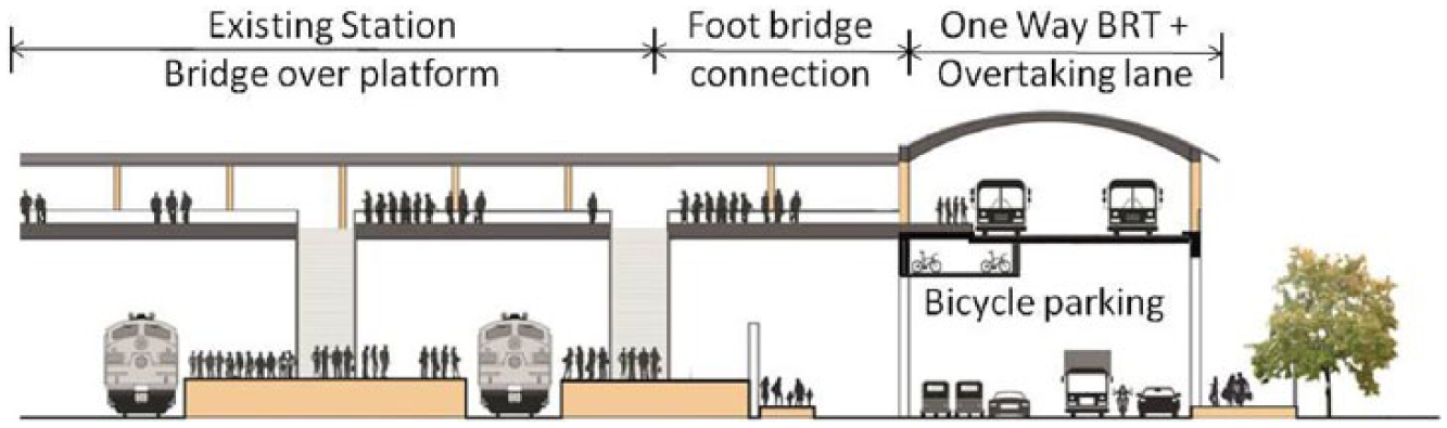
BRTS connectivity with a station at elevated footbridge level
Figure 2 shows cross-sections of the BRTS track between platforms and at a BRTS platform. Bicycle tracks and a footpath are provided on either side of the fenced-off BRTS. Users cross to the other side via the underpass at a BRTS platform.
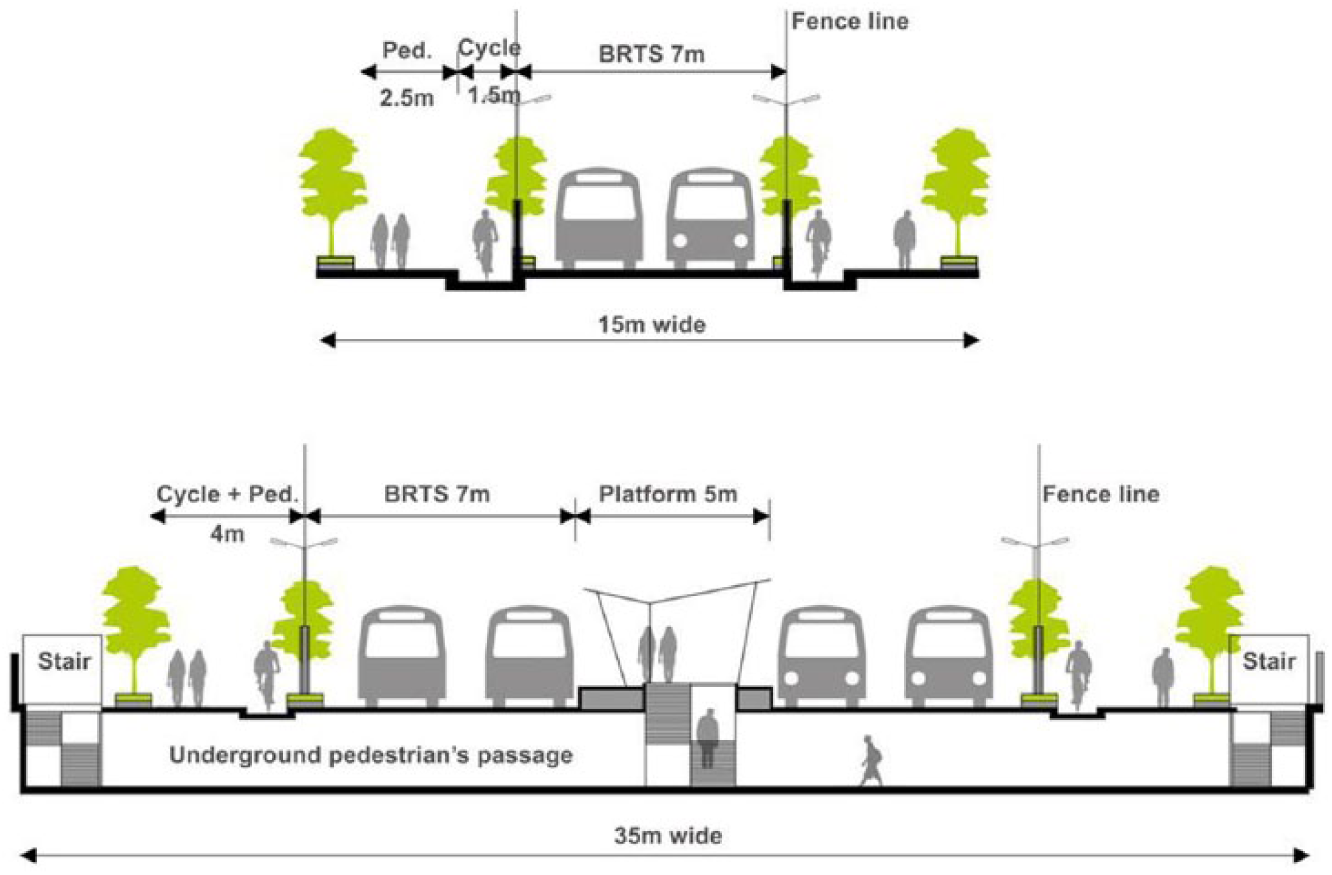
Typical cross-section of the BRTS right-of-way between platforms and at a typical platform
Figure 3 shows the island platform, accessed by a pedestrian underpass via a fixed ramp at one end and a movable staircase at the other. Platforms may be long enough for one bus to begin with, but are expandable at the staircase end as needed.
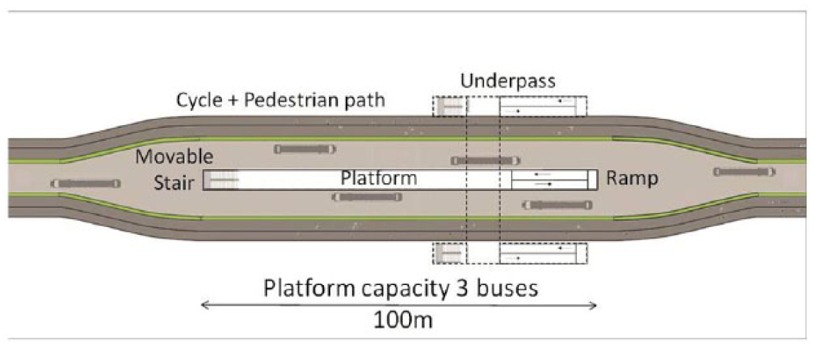
Island platform design for BRTS
Figure 4 shows the underpass widened at alternate platforms to allow cars to cross under the BRTS. Heavier vehicles would use shallow-rise overbridges spaced every few kilometres. The road network for cars and other motorized vehicles through the development is completely grade separated from the ground-level BRTS. Only at the railway station is the BRTS track lifted to deliver passengers at footbridge level. Just before this would be a roundabout on the BRTS two-way track through the settlement, from which another one-way track loops up to the station and back down to the roundabout.
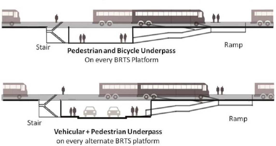
Underpass design for BRTS
An alternative to underpasses at every BRTS platform is shallow overbridges, just high enough to clear BRTS vehicles below. Underpasses would have a floor about 3 metres below the BRTS track; overbridges would be about 4.5 metres above the track. Underpasses are generally more inviting for pedestrians than overbridges because one begins with a descent;(12) and the greater height of the overpass means a longer ramp on either side.
III. Financial Viability
To be replicable, the proposed development needs to be self-financing, without any dependence on external subsidies. That is, we must recover from occupants the cost of land + physical and social infrastructure + construction of their own homes, all at a price they can afford. International practice recognizes that four years’ income for a household is an acceptable standard for housing affordability.(13)
a. Income-based housing affordability
Figure S2 in the online supplement(14) shows the 2015 monthly income profile for households in Mumbai(15) (median income is about US$ 600).
Column 1 in Table 1 shows ranges of monthly household income. Column 2 shows the percentage of the population in each income range, excluding the 4 per cent in the highest income bracket, which we consider irrelevant to the scheme. Column 3 lists four years’ income for each category – that is, Column 1 multiplied by 48 months. In Column 4 we suggest house sizes for each income category, based on what in Mumbai would be generally acceptable.(16) We assume construction costs vary from US$ 270 per square metre for the lowest income group to US$ 360 for the highest, and that US$ 300 per square metre is the cost for workers’ spaces (see page 8 for what these are). The cost of construction is in Column 5. Column 6, the difference between Columns 3 and 5, represents the surplus after construction available per household in each income group to pay for land and infrastructure. Note that it is negative for the lowest income group – that particular group cannot afford to pay for house construction, let alone land and infrastructure.
Affordable land cost with four years’ income from 1,000 households
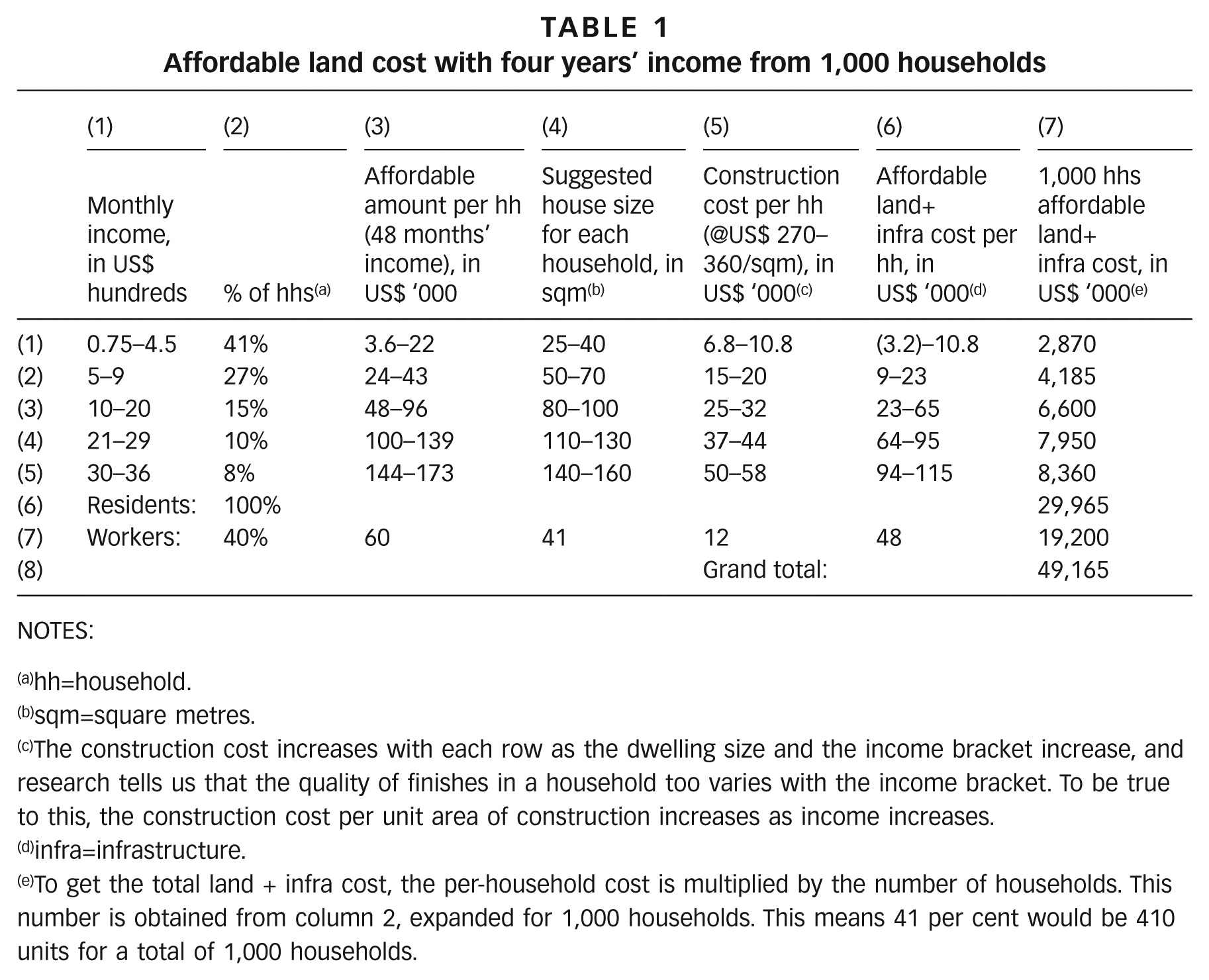
NOTES:
hh=household.
sqm=square metres.
The construction cost increases with each row as the dwelling size and the income bracket increase, and research tells us that the quality of finishes in a household too varies with the income bracket. To be true to this, the construction cost per unit area of construction increases as income increases.
infra=infrastructure.
To get the total land + infra cost, the per-household cost is multiplied by the number of households. This number is obtained from column 2, expanded for 1,000 households. This means 41 per cent would be 410 units for a total of 1,000 households.
We convert fractions in Column 2 to absolute numbers in each income group for every 1,000 households that we expect in our development. Multiplying these absolute numbers by the surplus per household in Column 6, Column 7 shows the surplus generated by each income category.
We do not want a purely residential development. Intermingled jobs would be desirable.(17) The employment ratio in Mumbai is 40 per cent. So we provide for a commensurate number of jobs. The resident population itself will generate many lower-income jobs, ideally taken up by local residents to minimize their transport costs. Other jobs would be filled by locals and outsiders using the BRTS to shorten the final leg of their journey to work. We should not inhibit the mixing of residences and zero-nuisance businesses in the same building, nor be too rigid about proportions of residential to work space – let the market decide that, and keep planning flexible enough to accommodate variations. To calculate area requirements and construction costs we assume 9 square metres of built-up area per job,(18) and a floor area ratio(19) of 1, which allows for a mix of single- and multi-storeyed construction.
In Table 1, Rows 1 to 6 are for residential construction. Row 7 concerns construction of workplaces. Row 7, Column 2 shows the percentage of all households that is employed (40 per cent). Assuming Mumbai’s average household size of 4.5 persons, with an employment floor space requirement of 9 square metres per worker, we get about 40 square metres required for 4.5 workers (Row 7, Column 4). Since we are calculating per household, we might think of this as “workers’ spaces” for computational purposes, with each accommodating 4.5 workers (as in a household). The affordable value for this, after paying for construction (Row 7, Column 6) is based on current business property prices per square metre at sites similar in location to the two sites studied below.(20)
From our 1,000 households, each paying four years’ household income, after paying for all house construction, we have a surplus of nearly US$ 29 million. The additional 400 workers’ spaces also generate a surplus of US$ 19 million, the difference between market price and construction cost. Thus for every 1,000 households + 400 associated workers’ spaces, we have nearly US$ 48 million to pay for land + physical and social infrastructure.
If we are unsuccessful in attracting the highest income group to the settlement, we could reduce their home sizes to attract the second-highest income group, and rework the calculation accordingly. Or we could remove that highest income group entirely, and increase the percentages proportionately for all the remaining groups. But for the moment we can work with the figure of US$ 48 million for 1,000 households + 400 associated workers’ spaces, or about US$ 48,000 per residential household as the surplus available to fund the entire development, excluding only building construction costs already allowed for.
b. Land required
We start by assuming a within-plot density on buildable plots of 270 households per hectare. In the successful 30-year-old Charkop project,(21) density in low-income areas is 278 households/hectare,(22) which would still be considered acceptable in Mumbai. Other contexts of course may call for different assumptions of viable density.
An important assumption here is that the same density applies across income groups, so wealthier residents, taking up a larger floor area, will live in taller buildings. Moreover, each household accounts for the same land area (with identical plot densities of households per hectare across all income groups). Since we are taking four years’ income from every household, the wealthier are paying more per unit of land – a cross-subsidy – and land per se is differentially priced across income groups. This can be justified in many ways, including attractiveness of the location or building regulations, say, that might limit the volume of permissible construction or deny car access or parking in the lower-income locations. Or the charge for land could be uniform per unit of built-up floor space, and with uniform densities this would painlessly deliver the desired cross-subsidy.
At a density of 270 households/hectare, 1,000 households need 3.7 hectares of buildable plot area. The workers’ spaces for 1,800 workers at 9 square metres/worker work out to 16,200 square metres, which at a floor area ratio of 1 is 1.62 hectares of land.
We allocate 30 per cent(23) of the total area for roads and rapid transit, 4 per cent for institutions (mainly schools and hospitals), 13 per cent for parks (based on a minimum of 3 square metres per capita, low but acceptable in Mumbai) and the rest (53 per cent) for buildable plots. Of these, about 5 per cent is for purely industrial or commercial use and the balance for mixed use, mainly residential but with shops and offices allowed on such plots.
Our land area requirement is then as in Table 2.
Land area requirement for 1,000 residential households + 400 associated workspaces
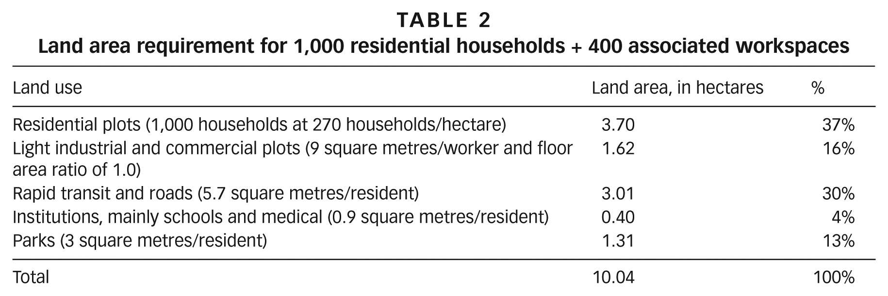
The gross residential density of the development would be 99.6 households/hectare (1,000/10.04). Assuming a family size of 4.5, this is 448 persons/hectare.
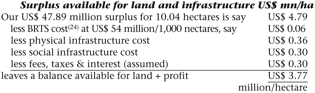
What is striking is how little the BRTS costs in relation to all other infrastructure. Providing this kind of dedicated transit service is not as extravagant as one instinctively imagines. The figures indicate that the scheme is financially viable wherever we can find land around Mumbai under US$ 3.77 million/hectare. This sounds eminently within reach in several places around the city.
Although we have accounted for interest on financing, we have not looked at cash flows or the seed financing needed to start the project. In India’s housing sales, buyers make down payments before construction begins, and further instalments as construction proceeds, so initial investments are rapidly recovered and no further financing is needed for later work. We would expect the implementing agency to assist buyers, particularly lower-income groups, to obtain available government subsidies and loans against mortgages on the property they are buying.
IV. Implementation
a. Land acquisition
The viability of the scheme is critically dependent on successful land acquisition. In Maharashtra most peri-urban land is owned by farmers or developers. Two mechanisms, tried earlier, are described below.
In the early 1970s CIDCO(25) provided monetary compensation to farmers for 344 square kilometres for the establishment of Navi Mumbai (New Bombay). With no experience of managing money, the farmers soon ran through their compensation and demanded more. In March 1990, almost 20 years into the project, it was decided to return to the earlier landowners developable plots equivalent to 12.5 per cent(26) of the acquired land area. Until then CIDCO’s steadily released plots had been selling well. Now suddenly it had competition from farmers offering large areas to developers. Land prices fell, and CIDCO lost its earlier financial buoyancy.
While such land acquisition processes are essentially compulsory for landowners, town planning schemes (TPS) are fundamentally voluntary, with government usually taking the initiative and providing leadership. In India, a state government issues a notification of several hundred hectares of contiguous land as a TPS, a layout is prepared, and some commercial plots are withheld by government for sale to finance infrastructure. The rest are distributed among original landowners in proportion to their original holdings. The proportion returned varies, but in Gujarat has recently been 50 per cent or more,(27) and the plots are now worth much more. What has been left out in such schemes is any serious provision for middle- or lower-income housing beyond occasional token gestures.
An interesting entirely private variant started in 1993(28) is Magarpatta City on the Mumbai-Pune Expressway, on 174 hectares once owned by 120 farmer families. Coercive land acquisition was replaced by an equitable, inclusive model for the original landowners, which emphasized their right to a say in the development process and maximized their returns to themselves. The youth in these families became second-generation landowner-entrepreneurs, training and acquiring skills to own and run support companies for construction and upkeep of the township. This worked as a process of social change through a policy of inclusion.
The initial investment required was only for preparation, submission and approval of plans. The Housing Development Finance Corporation (HDFC) Bank provided US$ 300,000 as an initial loan. The project became creditworthy when the bank also became its marketing partner and agreed to fund infrastructure.(29) Thereafter, instalments from pre-construction sales financed the entire development. The Pune Municipal Corporation approved the master plan, Magarpatta Township Development and Construction Company Limited (MTDCCL) was formed in 1995, and ground was broken in 2000. Farmers became shareholders in proportion to their original landholding. All land was transferred to the company.
Returns to farmers accrued in four ways. First, appreciation in property prices brought dividends from the company. Second, all farmers were encouraged to buy at least one residential property (at market value) within Magarpatta City. Many bought more, and rented them out for a regular income. Third, the non-residential commercial areas leased to various companies ensured a regular rental income to MTDCCL. Fourth, the original shareholders are now becoming shareholders in other projects as well.(30) We should remember that the Magarpatta initiative, while a co-operative, is strongly profit-driven, with no place for weaker-section housing and no improvement in transit facilities.
The Land Acquisition, Rehabilitation and Resettlement Act, 2013 is so pro-landowner that one can rule out compulsory land acquisition for a housing project. The only practical option left is a voluntary scheme like a TPS, and this is constrained by landowners’ expectation of getting back 50 per cent of their original area (as in Gujarat) as developed plots they can sell. This leaves nothing for middle- and lower-income groups.
We propose a variation on these two kinds of schemes, each of which has succeeded in its own way. The purpose is to make the scheme palatable to landowners as well as inclusive of lower-income groups. We assume that government is the driving force leading the initiative.
First, from the time the land is taken over we provide all landowners with an assured income equivalent to current earnings. This will eventually come out of the proceeds from sales of land and housing, but it implies start-up financing to cover these costs. This assured income should be indexed to inflation. The average income from farming in the area can be determined with help from the district collector.
Second, landowners are assured that they will be given developed plots in proportion to their original holding, adjusted to variations in their current land price. Such allotments should be across the income spectrum of developable plots.
Third, landowners are made minority shareholders of a development corporation that owns all the land and is entrusted with executing the project. Shares are inheritable but not tradable. Shareholders can only sell to the corporation, at a price based on the corporation’s current net worth. Shares can be pledged for their buy-back value against loans or mortgages. Once the corporation starts declaring dividends, these will replace the income assured under the first compensation. As long as shares are not sold back to the corporation, the original landowner and heirs are assured of a perpetual income of annual dividends guaranteed to never be less than the income assured at the start, although it could be more. This is over and above the windfall gains they could realize from sale of the plots allotted to them. To ensure that the corporation always has sufficient funds to provide income to the original landowners, all premises offered to incoming purchasers will be under a land lease sufficient to cover the annual disbursement.
We must concede that this is an untested proposal, and unlikely to be acceptable to existing landowners unless placed in the context of a wider government policy that mandates inclusionary housing.(31)
b. Governance of low-income housing
After Independence in 1947, private construction in India for renting to low-income groups stopped altogether. Existing rents were frozen at World War II levels, and new rentals were frozen at the value of their first letting. Private construction for sale to low-income groups was out of the question because they had no access to housing finance. The only low-income housing built was by government agencies on government land, and it met a small fraction of the total demand. Such housing was sometimes rented, but government soon found the management too difficult and preferred outright sale of these multi-storeyed housing units. Such units were organized into co-operative societies,(32) each comprising either a single building or a cluster of buildings.
As in other countries, the State Government of Maharashtra has now virtually stopped all construction of low-income housing on public land. Instead, it gets private developers to construct low-income units, handed over to government without charge, in exchange for extra floor space that can be built for sale on the same plot. Such units are then offered by government at well below market value. Getting such a unit is like winning a lottery.(33) These units are also organized into co-operative societies, where the occupant on resale realizes any appreciation in the value of the underlying land. However affordable a house may have been when allotted, at the time of resale, when the real and appreciated value of land is incorporated into the price, such an apartment will no longer be “affordable”.
For more enduring affordability, an alternative model of housing ownership and governance is required, where the land is taken off the market and the cost kept low for all time. A community land reserve (CLR)(34) is one such model.(35) The land is pooled, owned and managed by a single non-profit corporate entity on behalf of the community. Land parcels are given on a long-term lease to individuals or organizations to build on, with a clear contractual understanding that all appreciation in land value belongs to the CLR, not the lessee. The structures are owned by individual residents, who on resale can recover their investments, adjusted for inflation and depreciation based on a formula agreed with the CLR as a condition of the initial lease.
The governance of this non-profit entity is by a tripartite Board of Directors, one-third elected by resident members, another third by “general members” (residents of land surrounding this community), and the last third nominated by the first two-thirds and consisting of experts, professionals, government servants or other persons representing the public interest. Board members are re-elected every two or three years with limited successive terms. The Board focuses on community development while upholding an ethic of stewardship towards the land.
All Board meetings are open to (non-Board) members. Delicate matters may involve meetings from which members are excluded, but all decisions are taken in an open session. Thus transparency is much greater than for a traditional company with its shareholders.
Because a CLR retains ownership of the underlying land, housing remains permanently affordable even as the original owners sell and move on.(36) In effect, the CLR rents land to homeowners. It could just as well carry out construction and rent the finished house, or act as a guarantor for the owner to a housing finance agency.
By locking in permanent access to affordable housing, CLRs can play an important role in ensuring that low-income households remain distributed throughout a growing city. The incoming poor would not be forced to seek shelter only on the city perimeter, from which, as the city expands, commuting to work would be increasingly costly, in both time and money. With stewardship of land for the public good and not for speculative profit, CLRs can play an important role in stabilizing communities and ensuring they encompass the widest possible range of income groups.
Housing finance for the urban poor has always been a problem. Ways to obtain it have been successfully explored, for instance, by the Alliance of SPARC, Mahila Milan and the National Slum Dwellers’ Federation.(37) Micro-finance institutions are beginning to develop in India,(38) but perhaps conventional banks would agree more readily to dealing with a CLR, as a single-point collector of individual instalments. Or better still, the CLR might decide to build the house and rent it out. Many poor households might prefer rental to ownership.(39)
c. Generic layout plan
Assuming that the BRTS loop serves an immediate walkable community of 500 metres of development on either side, and that BRTS platforms are spaced 700 metres apart, we suggest a possible layout in Figure 5. The green plots could be parks, schools or other common amenities. Roads would be hierarchical, with a 24-metre arterial road crossing under every alternate platform (every 1.4 kilometres) as an underpass for light vehicles only. A grid of 9-metre local roads and 12-metre and 18-metre feeders would further serve the neighbourhood.(40)
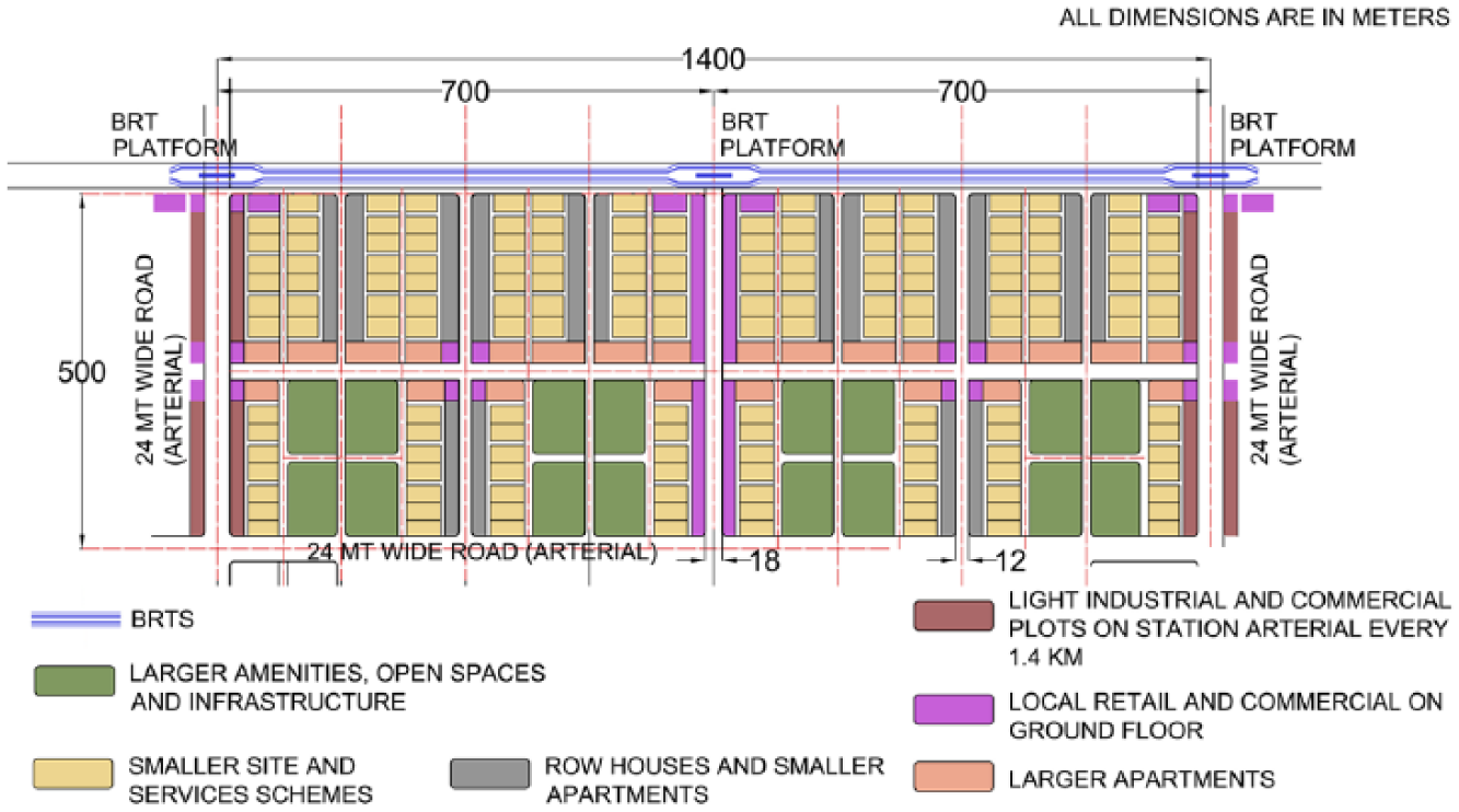
Generic layout plan option for BRTS-led affordable housing development
Light industrial and commercial plots could be along the 24-metre arterial roads to form a compact commercial zone for the community close to each BRTS platform.
Residences could then be located between the BRTS and the amenity hubs. Smaller households and sites-and-services schemes would be distributed within the development, accessed by 9-metre lanes to reach the less desirable and cheaper plots. Multi-storey dwellings for higher-income households would be planned along the arterial roads with better vehicular accessibility, more buildable area permitted and higher land prices. Mixing residences with other no-nuisance business uses would be encouraged.
The layout shown in Figure 5 is not a model, but is provided just to demonstrate the viability of the scheme. Detailed area layout planning should be deferred until it is really needed, and then, within overall constraints, should be flexible, sensitive to heritage sites, natural features and local topography, and responsive to market indicators.
But it is equally vital that this flexibility be fully consistent with the principles that guide the overall scheme (set out in the introduction), which need to be rigorously respected and firmly adhered to.
d. Transportation
Here we only flag two issues whose resolution is critical to success:
The capacity of the suburban railway station to cater to the additional demand created by the new settlement;
The financial viability of the BRTS. Apart from being fast and reliable, it also needs to be cheap.(41) This almost certainly implies a subsidy,(42) whether a surcharge on electricity tariffs, on property taxes, or some other carefully considered progressive tariff independent of BRT ticket cost to travellers.(43) Those who frown at subsidies should know that bus systems around the world are subsidized, and that this can be amply justified by their contribution to reduction in traffic congestion and pollution.(44)
e. What is needed for implementation?
Once a suitable and financially viable site has been found, a series of complex steps involving multiple players must ensue to reach a successful conclusion. The complexity and magnitude of the task are best addressed by a corporation specifically set up for the purpose, with a long-term commitment to continued success. The lead promoter could be a government officer with sufficiently wide-ranging powers, or a developer, leading a consortium of developers, who supports the objective of a desirable pattern of settlement and not just one that maximizes profits. If a developer leads the project, a succession plan needs careful thought, transferring control to a body with lifetime commitment. For a developer to be interested in this kind of scheme, an inclusionary government housing policy would need to be in place, mandating housing for the poor as an essential component of every project across the city for either housing or employment. Whether led by government or a private developer, the corporation must have adequate powers to charge fees or taxes to meet maintenance and operating costs, and active government support, both in the early years and beyond.
It is important that the corporation sets up and manages the BRTS (or sets up a subsidiary to do this). Its contracts with individual plot owners must empower it to charge a regular fee for maintenance and upkeep, and to subsidize the BRTS if necessary (unless an alternative source has been identified). While the day-to-day working of the BRTS could be contracted out for specified periods, with contracts renewable depending on performance, the corporation must recognize its own ultimate responsibility for a high-quality, inexpensive BRTS as key to a successful development.
V. Two Possible Sites in North Mumbai
Mumbai’s 67.8-square kilometre linear island city extends into 370 square kilometres of suburbs to the north (Western suburbs) and north-east (Eastern suburbs).(45) Run by the Municipal Corporation of Greater Mumbai, these form the most populous part of the 4,355-square kilometre Mumbai Metropolitan Region (MMR), which includes seven other municipal corporations. The Mumbai Metropolitan Region Development Authority (MMRDA) is responsible for the MMR’s balanced development.
Two parallel suburban rail systems start at the southern tip of the island city, then fork into the Western and Eastern suburbs and continue into the MMR.
The two possible sites in Mumbai studied to establish the viability of our proposal are located in the Municipal Corporations of Mira-Bhayandar and Vasai-Virar in the Western suburbs (Figure 6). Both corporations are recommended by MMRDA as future growth centres.
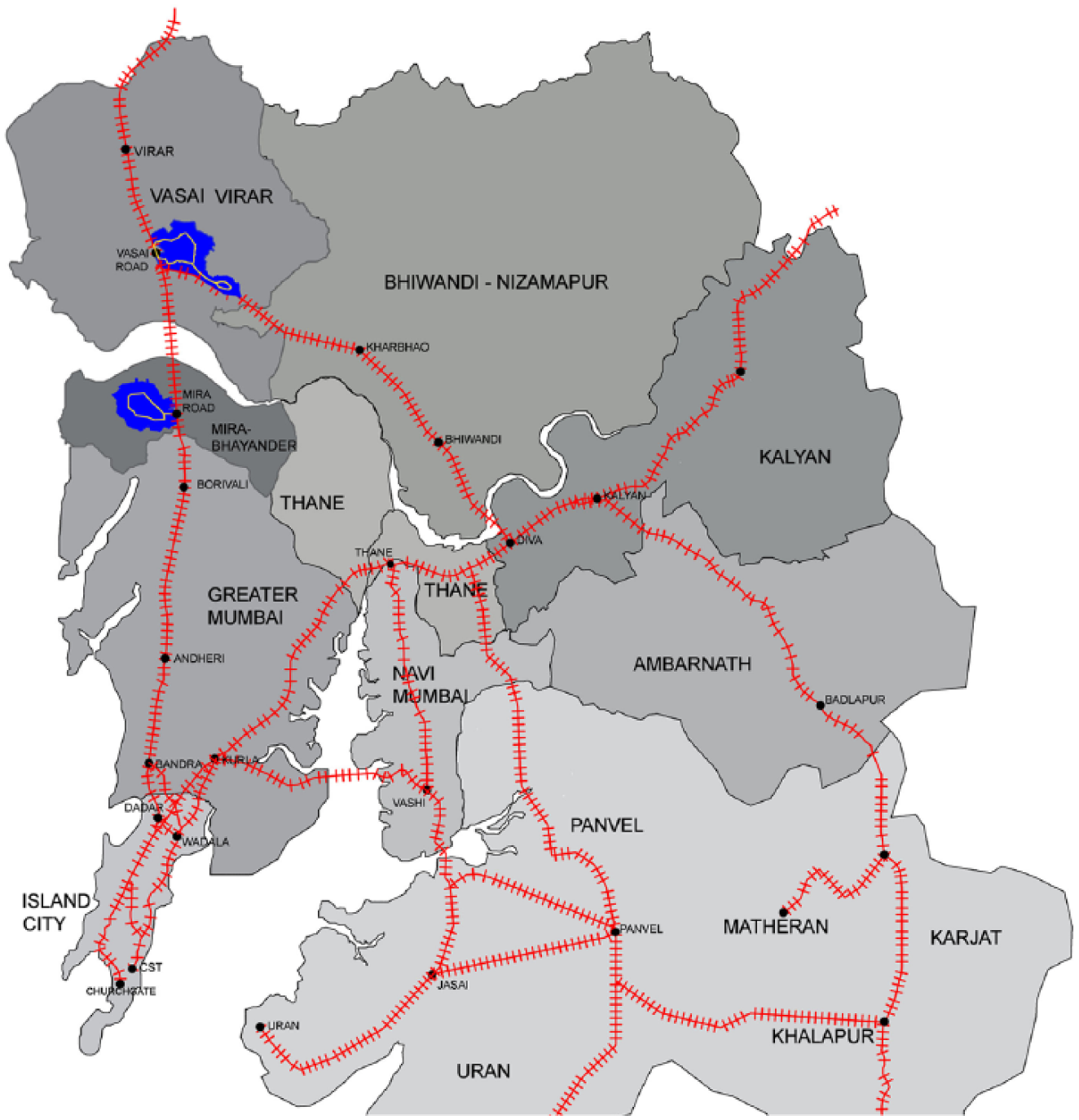
Municipal corporations and councils within MMR
The population of Vasai-Virar has more than tripled in the last two decades, from 365,480 in 1991 to 1,221,233 at the 2011 census.(46) From being primarily an agricultural town, Vasai-Virar is now a centre for manufacturing and service-related industries.
On the eastern side of Vasai Suburban Railway Station, an integrated BRT loop of 14.5 kilometres could open up almost 1,600 hectares of land, which could house approximately 717,000(47) people at a net developable plot density of 270 households/hectare, as well as 287,000(48) jobs. This could be developed as a town planning scheme (TPS) in one or two phases, depending upon land availability. Figure 7A shows TP1 with a land area of 1,370 hectares serviced by a 9.8-kilometre BRT loop, housing 614,000 people, or alternatively the much smaller (but somewhat overlapping) TP2 with a land area of 660 hectares serviced by an 8.5-kilometre BRT loop housing 296,000 people. An industrial belt already surrounds Vasai; the emergence of a mixed-use and mixed-income township development would further benefit the suburb in simultaneously creating employment and housing.
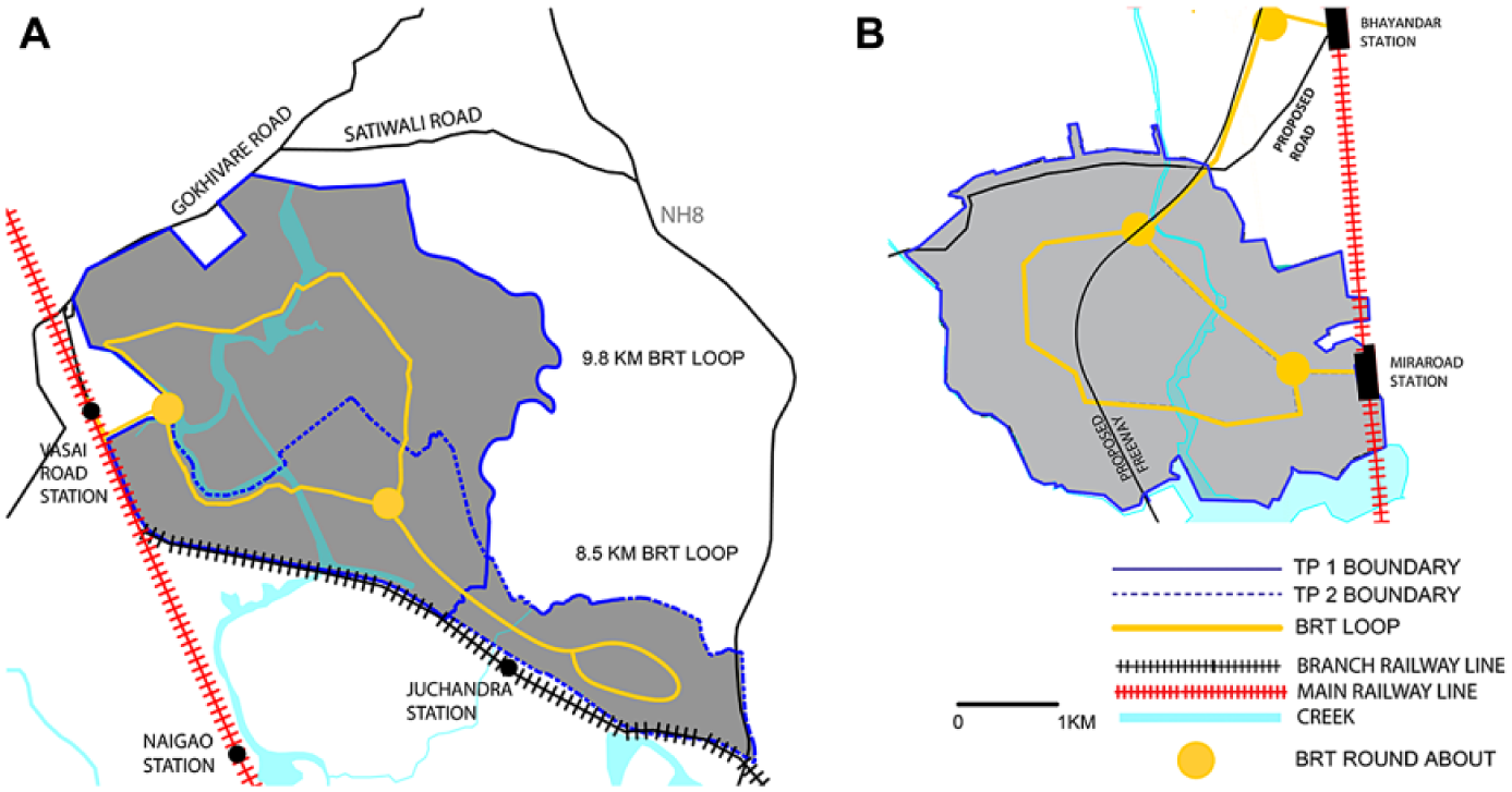
Vasai East TPS land area (A) and West Mira Road TPS land area (B)
Although the recent Draft Regional Plan 2036(49) demarcates this area as an urbanizable zone, certain natural and local political constraints reduce its developable capacity to about 45 per cent of the land area. But even developing this reduced fraction would usefully increase the city’s stock of affordable housing.
The second possible site is west of Mira Road Station, two stations further south. The area to the east of the station has seen maximum development, whereas the west side has been left untouched, reserved for a future electronic city. This 1,028-hectare area, with a 10-kilometre BRT loop, could house about 461,000 people and 184,000 jobs (Figure 7B).
The municipal corporation of this region is presently revising the land use plan – an opportunity for introducing a new model for affordable housing, limited only by some natural land constraints.
VI. Conclusions
This paper has proposed an approach to the development of affordable housing that could well be relevant to many cities in the developing world in situations not too dissimilar to the conditions prevailing in Mumbai. We calculate what a mixed-income settlement could generate by way of surplus if each household were to pay four (or possibly five) years’ income for housing. Deducting infrastructure and construction costs leaves a surplus that can pay for land and profits. If peri-urban land can be found within the price range of what the surplus offers, and which is also reachable by a feeder BRTS transit system connecting to the city’s transit network, then a scheme there would be both attractive to local residents and financially viable, requiring no external subsidy. The matter would then boil down to finding a local champion, who subscribes to the notion of a mixed-income development, and who can lead and drive the project to fruition.
Supplemental Material
patel-saluja-kapadia-supplement – Affordable housing needs affordable transit
Supplemental material, patel-saluja-kapadia-supplement for Affordable housing needs affordable transit by Shirish B Patel, Jasmine Saluja and Oormi Kapadia in Environment and Urbanization
Footnotes
Acknowledgements
This paper was much improved by inputs from an anonymous reviewer, Anuj Bhagwati, EMBARQ, Kieron Hendicott, Peter Bevington and V K Phatak.
Notes
References
Supplementary Material
Please find the following supplemental material available below.
For Open Access articles published under a Creative Commons License, all supplemental material carries the same license as the article it is associated with.
For non-Open Access articles published, all supplemental material carries a non-exclusive license, and permission requests for re-use of supplemental material or any part of supplemental material shall be sent directly to the copyright owner as specified in the copyright notice associated with the article.