
Abstract
This paper describes research investigating UN-Habitat’s experience supporting communities and local government to undertake urban planning following humanitarian crises. Two case studies were examined: Banda Aceh, Indonesia, following the Indian Ocean earthquake and tsunami in 2004; and Tacloban, the Philippines, following Super Typhoon Haiyan in 2013. The study found that urban planning following humanitarian crises can empower communities and governments to manage their own recovery. However, they may lack the knowledge, experience, time, tools or technology needed to take the lead. Organizations supporting urban communities and local government to undertake urban planning following humanitarian crises should consider: the most appropriate speed, scale and depth of the intervention given the context and their own funding and capacity; building local government capacity through secondments or partnerships; establishing a recovery and reconstruction planning task force; appropriate strategies for working with affected communities and their leaders; and advocating for national government support.
Keywords
I. Introduction
a. Background
Humanitarian crises such as displacement, conflict or natural disasters increasingly occur in urban areas.(1) This urbanization of risk presents a significant challenge for humanitarian agencies – both in the complexity of responding to urban disasters and in operating in environments in which these agencies lack significant experience and expertise.(2) In responding to urban crises, the Global Alliance for Urban Crises recommends that “humanitarian agencies work in support of and in collaboration with municipal authorities”.(3) However, while initiatives such as Making Cities Resilient(4) and 100 Resilient Cities(5) are working with city governments in advance of humanitarian crises, there are few examples of support during response, recovery and reconstruction and little guidance.
Urban planning(6) is one of the key responsibilities of local government, particularly after urban crises, when there are both urgent needs and opportunities to reduce the risk of future disasters.(7) However, while local governments may be closely connected to communities, governments typically have limited resources and capacity to meet communities’ needs,(8) especially when urban crises place staff under abnormal levels of demand.(9) Urban crises are infrequent, so planners are unlikely to be able to rely on personal or institutional memory.(10) There is also limited guidance available – either for urban planners working in humanitarian contexts or for humanitarian agencies trying to provide them with support.
Glossary
b. Aims and objectives
This paper reports the findings of a study that aimed to document learning from UN-Habitat’s(11) intervention supporting local actors with urban planning in Banda Aceh after the Indian Ocean earthquake and tsunami in Indonesia in 2004 and in Tacloban after Super Typhoon Haiyan in the Philippines in 2013.(12) The research addresses key evidence gaps in humanitarian response to urban crises, including: documenting the experiences and perceptions of local actors; analysing complex multi-sectoral and multi-scalar urban systems; and investigating longer-term impacts.(13) Additionally, the study compares recovery after the crisis in Banda Aceh, which has been under-researched,(14) with the more recent case in Tacloban.
The objectives of the study were to examine the process, outputs and effects of the collaboration between UN-Habitat and local actors with regard to urban planning; document the advantages and challenges of this approach; and analyse the contextual factors that helped or hindered its adoption and implementation. This paper highlights the key lessons from this research that may be useful for local governments, humanitarian agencies and donors working in similar contexts. Section II describes the context in each city and provides an overview of UN-Habitat’s intervention. Section III discusses the key lessons identified in this research. Section IV considers the implications for future policy and practice and makes suggestions for further research.
c. Methodology and limitations
This research followed a comparative case study design. This provided greater depth of understanding of the urban planning process in Banda Aceh and Tacloban by investigating the similarities and differences in each of the locations.
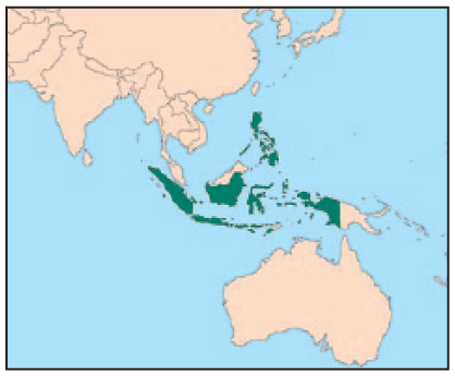
The case studies were chosen for their similarities and because UN-Habitat had undertaken urban planning programmes in both cities. Banda Aceh and Tacloban are similar in terms of their population, tropical climate and coastal location. They are also the social, economic and administrative centres of their surrounding provinces and have relatively high levels of autonomy from national government. In addition, Indonesia and the Philippines are both lower middle-income countries in Southeast Asia with comparable systems of decentralized governance and approaches to urban planning and disaster risk management.
Fieldwork was undertaken during July and August 2016. This included 52 interviews (33 in Indonesia and 19(15) in the Philippines) with key informants from communities, government, humanitarian organizations, academia and the private sector. Interviewees were identified through the authors’ professional networks and snowball sampling while undertaking the research. The fieldwork also involved workshops with community members involved in the programme (Indonesia) and current and former UN-Habitat staff (both countries); and direct observation in the form of guided tours of the city (both countries) and attendance at public meetings (the Philippines).
The diverse perspectives of key informants were analysed using logic models(16) alongside textual descriptions, tabulation, grouping and clustering, and conceptual mapping.(17) Interviews were given equal weight. In order to verify personal accounts, interview data were triangulated with direct observation and an extensive literature review. Finally, 14 of the key informants (eight in Indonesia and six in the Philippines) reviewed each of the working papers to verify the findings.
The research was undertaken after all (Indonesia) or the majority (the Philippines) of UN-Habitat’s activities had been completed, and limited UN-Habitat or secondary documentation was available to describe the interventions. This resulted in a strong reliance on key informants’ recollections of events – which is particularly challenging given the fast-paced and stressful nature of humanitarian interventions and the fact that the research was undertaken at a later date (approximately two and a half years after Super Typhoon Haiyan in the Philippines and almost 12 years after the Indian Ocean earthquake and tsunami in Indonesia). Wherever possible, the statements of interviewees were triangulated with each other and with available secondary data. However, it was challenging to capture all the details – a limitation of the research.
In the Philippines, a former UN-Habitat staff member was part of the research team and UN-Habitat provided introductions to potential interviewees – thereby introducing a risk of bias into both the selection of informants and the data collected. However, the advantages outweighed the disadvantages because this staff member provided access to a wide range of key stakeholders and detailed insight into UN-Habitat’s work. This risk of bias was mitigated during interviews by stating clearly that the former UN-Habitat staff member was functioning as an independent researcher. A researcher with no previous relationship with UN-Habitat undertook the analysis.
II. Case Studies
a. Pre-crisis situation
Banda Aceh is the administrative, economic and cultural centre of the province of Aceh in Indonesia. Prior to the 2004 earthquake and tsunami, the population of the city was 263,668 with an annual growth rate of 2.1 per cent. The main economic activities were commerce and fish cultivation.(18) The kota (city) consists of nine kecamatans (sub-districts) and 89 gampongs (wards or villages).(19) Included within the kota administrative boundaries are the historical city centre around the Baiturrahman Grand Mosque and the Krueng Aceh River, and coastal areas including the port of Ulee Lheu in the Meuraxa kecamatan. The city’s location and topography make it vulnerable to hazards such as earthquakes, floods, typhoons and tsunamis. By 2004, almost 30 years of conflict in Aceh between the Indonesian government and the Gerakan Acheh Merdeka (the Free Aceh Movement – known as GAM) had claimed between 15,000 and 20,000 lives and isolated Banda Aceh from rural areas and Aceh Province from the rest of the country.(20)
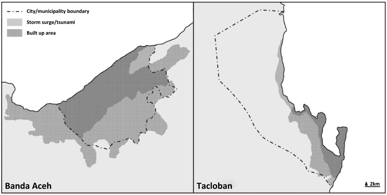
Tacloban City in the Philippines is the social, economic, transportation and administrative centre of the Eastern Visayas region. It was granted “highly urbanized” status in 2008 – giving it autonomy from the provincial government of Leyte. Prior to the typhoon, Tacloban City was the fifth fastest-growing city in the country, with a population of 221,174(21) and an economy focused on trade and commerce.(22) The municipality is sub-divided into 138 barangays (wards or villages), ranging from “downtown” barangays in central Tacloban to peri-urban suburbs and fishing villages, and to rural barangays in north Tacloban. The city’s location and topography make it vulnerable to typhoons, landslides, storm surges, earthquakes and tsunamis. It was devastated by a typhoon and storm surge in 1897 and again in 1912.(23) See Map 1 for the locations of Tacloban and Banda Aceh.
Banda Aceh and Tacloban
b. Disaster impact and immediate response
On 26 December 2004, a magnitude 9.0 earthquake struck off the coast of Aceh Province, followed within 30 minutes by a tsunami. In Banda Aceh, waves approximately 10 metres high devastated an area between 2 and 4 kilometres wide along the coast and left large areas of land submerged.(24) More than 60,000 people lost their lives in the city while more than 6,500 were reported missing. In excess of 17,000 houses were “totally damaged” while 4,193 were “partially damaged”.(25) Water, drainage, electricity and communication networks as well as administrative buildings, health and educational facilities, roads, markets and ports were also heavily damaged or destroyed. In the kecamatan of Meuraxa, one of the most severely affected, more than 30,000 people, or 80 per cent of the population, lost their lives.(26)
At the time of the tsunami, Aceh was under military rule and there was little presence of international agencies. The Indonesian military and the police were the first to support local people in responding to the disaster, while the Indonesian government requested international assistance after securing a ceasefire from GAM.(27) In the first few months, the UN High Commissioner for Refugees coordinated the shelter response but it handed over this responsibility to UN-Habitat, which established and coordinated a Shelter Working Group from April 2005 to May 2007. Meanwhile, more than 100 organizations began implementing shelter programmes – many with little or no previous experience with shelter.(28)
On 8 November 2013, Super Typhoon Haiyan (known locally as Yolanda) devastated the Visayas region of the Philippines. Tacloban was on the direct path of the super typhoon and experienced wind speeds of more than 300 kilometres/hour and a 5-metre storm surge.(29) More than 2,600 people lost their lives and 701 were reported missing.(30) More than 28,500 houses were categorized as “totally damaged” while 17,643 were “partially damaged”. All seven hospitals and 17 public health facilities sustained major damage, as did educational facilities and the city’s electricity, water and communications networks.(31)
In the first few days after the typhoon, the Philippine government declared a state of national calamity and accepted international humanitarian assistance. The Inter-Agency Standing Committee (IASC)(32) subsequently launched a system-wide (“level three”) activation of the humanitarian system (immediately deploying significant international resources and capacity), coordinated via sector-specific clusters.(33) In the first 100 days of the response, the 55 organizations reporting to the Shelter Cluster provided tarpaulins or tents to almost 500,000 households, while more than 55,000 households received tools, building and roofing materials to enable families to repair their own homes.(34)
Impacts of the crises are listed in Table 1.
Tacloban, Banda Aceh and Meuraxa – before and after the crises
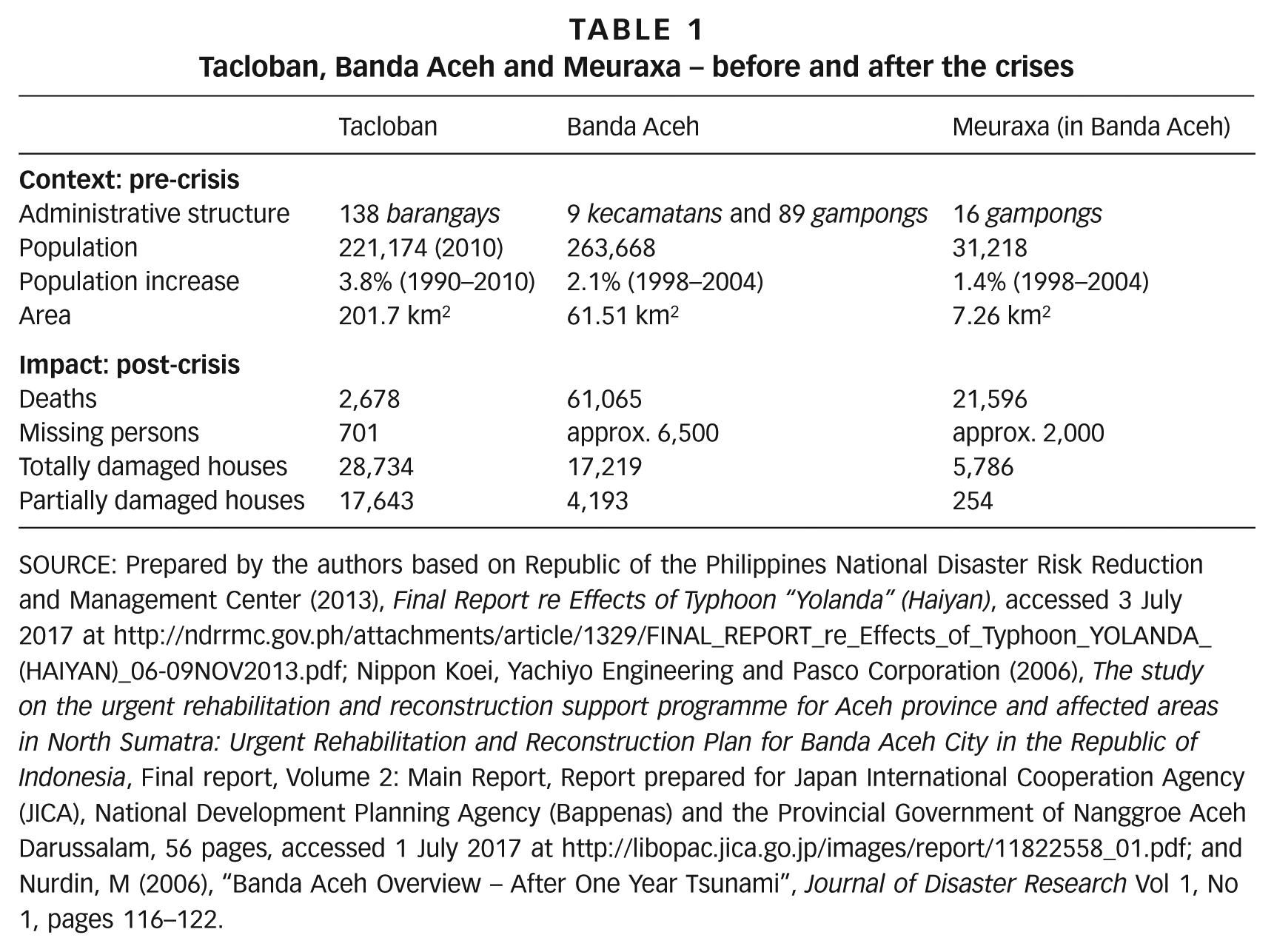
SOURCE: Prepared by the authors based on Republic of the Philippines National Disaster Risk Reduction and Management Center (2013), Final Report re Effects of Typhoon “Yolanda” (Haiyan), accessed 3 July 2017 at http://ndrrmc.gov.ph/attachments/article/1329/FINAL_REPORT_re_Effects_of_Typhoon_YOLANDA_(HAIYAN)_06-09NOV2013.pdf; Nippon Koei, Yachiyo Engineering and Pasco Corporation (2006), The study on the urgent rehabilitation and reconstruction support programme for Aceh province and affected areas in North Sumatra: Urgent Rehabilitation and Reconstruction Plan for Banda Aceh City in the Republic of Indonesia, Final report, Volume 2: Main Report, Report prepared for Japan International Cooperation Agency (JICA), National Development Planning Agency (Bappenas) and the Provincial Government of Nanggroe Aceh Darussalam, 56 pages, accessed 1 July 2017 at http://libopac.jica.go.jp/images/report/11822558_01.pdf; and Nurdin, M (2006), “Banda Aceh Overview – After One Year Tsunami”, Journal of Disaster Research Vol 1, No 1, pages 116–122.
c. Post-crisis governance
In Indonesia, the national government appointed BAKORNAS PBP (the National Disaster Management Agency) to coordinate the emergency relief effort and BAPPENAS (the National Planning Agency) to lead recovery and reconstruction planning in the first three months of the response.(35) Both agencies handed over responsibility to the newly created Badan Rehabilitasi dan Rekonstruksi NAD-Nias (the Office of Rehabilitation and Reconstruction for Aceh and Nias – known as BRR) upon its establishment in April 2005. BRR had a four-year mandate and was responsible for the coordination and implementation of recovery activities following BAPPENAS’s Master Plan for the Rehabilitation and Reconstruction of Aceh and Nias (known as the “Master Plan”).(36) Conflict continued in rural areas in Aceh until the signing of a peace agreement in August 2005.(37) This was followed by the Law on Governing Aceh (LoGA) in July 2006 (which devolved significant power and resources from national to provincial government) and the first democratic elections in December.(38)
Indonesian law states that spatial planning should be undertaken from the top down(39) and a spatial plan for Banda Aceh was included in BAPPENAS’s Master Plan for the entire response. However, the Master Plan allowed for little involvement of local stakeholders and was resisted by communities, local government and NGOs for three reasons: they had been excluded from the process; the resulting plan was too macro and too difficult to implement; and they were opposed to the proposed “buffer” (or no-building) zone extending 2 kilometres from the coast. BRR’s “village planning” approach,(40) on the other hand, promoted from June 2005, involved rapid, community-driven spatial planning at the gampong level and approval by community leaders.(41)
In the Philippines, Local Government Units (LGUs) are mandated to develop a Comprehensive Land Use Plan (CLUP) to guide the long-term development of the municipality. This is supported by a Comprehensive Development Plan that details the implementation process. LGUs also have the primary responsibility for disaster management and response.(42) Consequently, national government requested that each LGU develop a recovery and rehabilitation plan (RRP) following Super Typhoon Haiyan. These were to be submitted to the Office of the Presidential Assistant for Rehabilitation and Recovery (OPARR) for inclusion in the national government’s Comprehensive Recovery and Rehabilitation Plan (CRRP) for the Typhoon Haiyan response, and subsequent access to funding.
d. Intervention
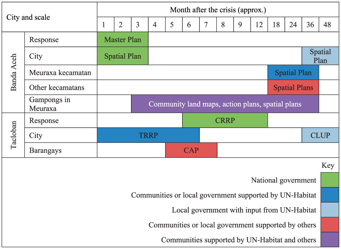
In Banda Aceh, UN-Habitat supported a lengthy bottom-up planning process – supporting communities and local government to develop spatial plans at the dusun (neighbourhood), gampong, kecamatan and later city levels.
In Tacloban, UN-Habitat worked with the LGU and key stakeholders to rapidly develop a strategic recovery and rehabilitation plan for the city that later informed updates to the city’s spatial plan (Figures 1 and 2). In both cities UN-Habitat established forums to coordinate recovery planning activities.
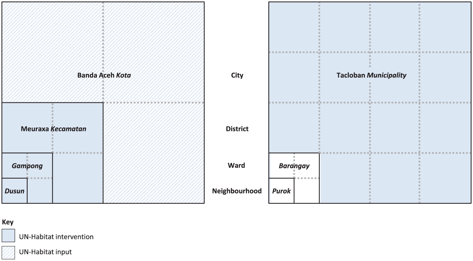
Scale of the interventions
Timing of the interventions
Planning
In Banda Aceh, UN-Habitat worked with communities and local government for more than five years, starting in January 2005. First, UN-Habitat supported communities in three gampongs in Meuraxa (where it was also supporting households to rebuild their houses) to undertake land mapping and adjudication(43) followed by community action planning.(44) Later, UN-Habitat supported all gampongs in Meuraxa to undertake spatial planning at the dusun and gampong levels (although some had already been provided with community mapping/planning assistance by other organizations). From June 2006, UN-Habitat then worked with communities and local government to combine action plans and spatial plans from each of the 16 gampongs into the “Vision for Green Meuraxa” strategic plan and subsequent spatial plan for the kecamatan. It also collaborated with these local actors to integrate the spatial plan for Meuraxa with similar plans from eight other kecamatans into the mid-term city-wide development plan (2007–2012) and subsequent regional spatial plan (2009–2029) for Banda Aceh City. From 2007 there were also efforts to integrate the lists of priorities identified through the CAP process into the annual musrenbang.(45)
In Tacloban, UN-Habitat supported the LGU and key stakeholders to rapidly develop the Tacloban Recovery and Rehabilitation Plan (TRRP) for the city within the first six months after the crisis. This was submitted to OPARR for approval and inclusion in the national government’s Comprehensive Recovery and Rehabilitation Plan (CRRP) and later served as a “conceptual roadmap” for updates to the city’s Comprehensive Land Use Plan (CLUP).(46) UN-Habitat also provided additional support to the LGU for the development of planning documents required as inputs to the CLUP – for example a draft Local Shelter Plan and a Local Climate Change Action Plan, the latter of which was being drafted at the time of the research (July 2016). One organization supported residents in some high-risk coastal barangays to undertake community action planning in April, May and June 2014 prior to implementing settlement-level infrastructure projects.(47) However, the relationship of these barangay-level plans with the TRRP was unclear.
Coordination
To coordinate activities in Banda Aceh, UN-Habitat established the Komite Rehabilitasi dan Rekonstruksi Meuraxa or Forum Korrexa around 18 months after the crisis. The Forum met weekly in Meuraxa and was attended by 20–40 people (including representatives from communities, local government, BRR, UN agencies, other donors and implementing agencies) plus nine UN-Habitat staff. Additionally, UN-Habitat and UNORC(48) established a Working Group, which met at the Banda Aceh City Hall from 2006 to 2008 to discuss community issues and needs that were not addressed in Forum Korrexa. The Working Group included NGOs, local government officials from Meuraxa, and representatives from government departments and Banda Aceh City. It was sub-divided into smaller working groups depending on the issues raised.
In Tacloban, UN-Habitat also supported the LGU to establish the Tacloban Recovery and Sustainable Development Group (known as TACDEV or TRSDG), within a month of the crisis, to lead the planning process.(49) The TRSDG was sub-divided into a steering committee, a secretariat, and five technical working groups. All members of the TRSDG attended two major planning workshops (each attended by 50–100 people) and had ad-hoc meetings as required.
e. Effects
In Banda Aceh, active engagement in the collective planning process helped residents of Meuraxa Kecamatan to “revive their spirits and solidarity” according to a BRR case study.(50) In the longer term it also increased the capacity of communities to understand and contribute to mapping and planning activities as part of the musrenbang and other development plans. The success of Forum Korrexa, plus the request of newly elected Bupati (district heads) and Walikota (mayors) following the elections in December 2006 for a strategy and planning platform, led to the establishment of 23 Kabuptaten/Kota Recovery Forums (District/City Recovery Forums) between 2007 and 2009.(51) As of July 2016, most of the proposals in the Meuraxa Kecamatan plan had been completed. In general, the spatial structure of Banda Aceh City is now more organized than before the tsunami, while hazard mitigation measures have also been implemented. However, the city is still susceptible to vanity projects (such as the construction of flyovers) by elected leaders.
In Tacloban, the two most critical planning items in the TRRP were the implementation of “no-build zones” and the proposed city extension (known as Tacloban North). Both of these required significant relocation of the city’s population away from coastal areas to sites inland. As of July 2016, construction of new houses on sites in Tacloban North stood at varying degrees of completion and occupation. Households that have moved or are anticipated to move from the “no-build zones” to the relocation sites have voiced concerns regarding the availability of water, access to livelihoods, additional costs of transportation and land rental, hazards such as flooding and proximity to a landfill site, and the impacts for social cohesion.(52) Meanwhile, the majority of residents living in the “no-build zones” had rebuilt their homes in-situ.
In both countries, the ongoing mentoring and technical support from UN-Habitat increased the skills and knowledge base of local government staff, as well as introducing them to useful tools, technologies and frameworks. In Banda Aceh, the increased coordination skills of both local and national government have made it easier for them to facilitate the regular development planning of the city through activities such as the musrenbang. More broadly, their experience working with national government departments and international organizations has increased the capacity of staff in the city government for collaboration and learning with other local governments both nationally and internationally.
III. Discussion
a. UN-Habitat funding and capacity
UN-Habitat did not have long-term funding for urban planning support in either of the cities. Instead, different donors funded specific activities and outputs (such as developing the spatial plan for Meuraxa Kecamatan or the Tacloban Recovery and Reconstruction Plan), while UN-Habitat worked to secure additional funding from other donors or programmes to continue the work. In Banda Aceh, UN-Habitat secured sufficient funding to support a bottom-up planning process that eventually took more than five years. In Tacloban, UN-Habitat found that donors were unwilling to fund an urban planning programme. Consequently, UN-Habitat’s relatively high-level and rapid intervention focused on working with local government officials and key stakeholders rather than with communities directly. However, even with only two UN-Habitat staff members at city level, the organization’s top-down urban planning support enabled the LGU to develop a city-wide recovery and rehabilitation plan (the TRRP) within six months of the crisis.
According to Olshansky and Chang, “the central issue in post-disaster recovery is the tension between speed and deliberation”.(53) This tension implies a need to plan at the speed and scale that are likely to have the greatest impact. The mandates, structures and funding of humanitarian agencies, however, make it difficult to target interventions at the community rather than individual or household level.(54) Integrating plans developed at neighbourhood level with those at city or regional scales can also be a challenge.(55) Comparison of UN-Habitat’s urban planning support in both cities endorses Schwab et al.’s view that rapidly developing a city-wide recovery plan can provide a vision and framework for decision makers as long as it has sufficient credibility through local involvement and support.(56) The case studies also illustrate how rapid intervention at city level has the potential both to inform a broader plan for the response (potentially enabling the city to access funding) and to identify areas of the city that would benefit from more detailed multi-sectoral and participatory planning approaches.(57) However, both case studies highlight the significant time and resources needed to integrate recovery plans into the next iteration of the city’s comprehensive plan.
b. Building local government capacity
A second key issue was that of local government capacity. Both case studies described the limited financial, technical and human resources of these city governments prior to the humanitarian crises. In Banda Aceh, the ongoing conflict had left both local and national government departments with very limited capacity,(58) lacking the trust of communities(59) and facing accusations of poor performance and corruption.(60) In Tacloban, meanwhile, staff had little first-hand experience of planning because (as is common in the Philippines) the previous CLUP had been developed by external consultants. Limited pre-existing capacity in both cities was exacerbated by the destruction of offices, records and datasets during the crisis. In both cities, government officials lost their lives – for example, in Banda Aceh the National Land Agency lost up to 30 per cent of its staff,(61) while only two out of 16 Keuchik (elected Heads of Village) in Meuraxa Kecamatan survived.(62) In Banda Aceh, the elections in December 2006 also brought to power many newly elected mayors and district leaders who often had very little experience in public administration.(63)
The case studies also provided practical insights into the challenges facing city governments following humanitarian crises and the types of support required. The findings of the study were compatible with the opinion of experts at DFID’s workshop on humanitarian response to urban crises, that local governments “may require technical expertise in specific aspects of urban humanitarian response but also extra staff to cover the additional administrative and management burden”.(64) This is because government officials in both cities needed to deliver services in very difficult circumstances while simultaneously planning for the future. They also needed to meet the immediate needs of their own families in terms of housing, access to services and personal safety.
The Global Alliance for Urban Crises recommends seconding urban specialists into city governments from local governments, the private sector or academia elsewhere in the country to supply additional staffing, provide specific expertise, and build long-term capacity.(65) Effectively, UN-Habitat personnel in Tacloban were seconded into the LGU and “acted as an extension of the city”.(66) The LGU provided office space for one or two UN-Habitat staff near the Planning Department, which was leading the development of the TRRP. This was important because, according to a local UN-Habitat staff member, the “culture in the Philippines [is] when you are here, you are respected … people see you every day and they listen to you”.(67) UN-Habitat personnel in Tacloban were Filipino planners – often recruited from academia. While not experienced in humanitarian response, they were knowledgeable about urban planning, experienced, committed, personable and enthusiastic; they also had strong professional and personal networks. The relatively few UN-Habitat staff in Tacloban were supported by senior UN-Habitat staff based in Manila for “surges” such as workshops. As in Banda Aceh, the organization also partnered with teams of national and international experts to provide specific technical expertise.
c. Establishing a recovery and reconstruction planning task force
UN-Habitat established task forces in both cities. These improved coordination between stakeholders as well as increasing the capacity of local government to coordinate future planning activities. Coordination was hampered, however, by factors such as lack of space for offices or meetings; limited electricity, phone coverage or internet access for phones or computers; and poor or inconsistent attendance of key stakeholders at planning meetings. The case studies support Schwab et al.’s recommendation that the task force is best led, or at least initiated and strongly supported, by the mayor of the city and that participants should be chosen carefully both to ensure technical accuracy and to enhance political acceptability.(68) In Banda Aceh, significant involvement of both the mayor of the city and the governor of the province minimized delays caused by lack of national government capacity. In Tacloban, the support of the mayor, as chair of the TRSDG steering committee, meant that local government and key stakeholders prioritized the planning process even though there were many demands on their time.
The task forces took different approaches to dissemination, with quite different results. In Banda Aceh, discussions of the Forum Korrexa and the Working Group were disseminated via a weekly newsletter (published every Friday morning and placed at the door of every mosque before Friday prayers); a community radio station; and telephone and text messages. Draft versions of gampong and kecamatan plans were also displayed in the local government office. Conversely, in Tacloban, given the short time frame of the development of the TRRP and the many pressures on stakeholders leading the process, there was less focus on dissemination. However, social media were used to provide periodic updates,(69) and in March 2014 the Mayor and UN-Habitat presented the draft TRRP at an open meeting attended by 2,000–5,000 people. However, the TRRP has not been widely circulated to stakeholders, even some of those who were involved in the planning process. The lack of access to the TRRP is especially problematic for the residents of the city. It has made the process and resulting plan opaque, and it is difficult for people to connect to the vision or to assess details that directly relate to their lives. There is no opportunity to appraise the data on whose basis the strategy is developed, nor is it possible to hold the LGUs accountable.(70)
d. Working with communities and community leaders
The Global Alliance for Urban Crises recommends that humanitarian response to urban crises actively involve affected communities and build on local knowledge.(71) However, the case studies highlighted the challenges of working with affected communities during the initial stages of the response; the dangers of using “participatory” as a blunt term without analysing the various levels of power sharing and decision-making;(72) and the skills, experience, time and resources required to engage communities in strategic and spatial planning in a meaningful way.
Initially UN-Habitat found it very difficult to work with communities in Banda Aceh, as many people had died and the survivors were traumatized, grieving, searching for lost family members, living remotely with friends and relatives, or staying in “barracks” (government-built collective centres). To work around this, UN-Habitat initiated community engagement at the household level and built up to focus groups and larger workshops at dusun, gampong and kecamatan levels over time. The Keuchik in each gampong played a critical role in helping residents understand the importance of spatial planning, encouraging participation and resolving conflicts, but this was difficult as many Keuchik had died in the earthquake and tsunami. Supporting new community leaders therefore became one of UN-Habitat’s priorities, but it took time for new leaders to gain the respect of their communities.
UN-Habitat’s community facilitators in Banda Aceh were mostly young male Acehnese urban planners and architects. Often recent graduates, the facilitators were highly motivated. They knew the local culture and context and were willing to sit with, and sometimes live with, communities in order to build trust and learn about their challenges and priorities. Despite their commitment, however, the facilitators lacked adequate institutional support. Experts on community engagement were not initially included in the programme, but even after hiring an experienced Indonesian anthropologist, UN-Habitat did not adequately define a framework for community engagement or provide an exit strategy. While this allowed for flexibility at field level it also resulted in different approaches to the planning process in each of the 16 gampongs. In the words of a former community facilitator, “it was like a learning by doing project” and consequently took a lot of time.
e. Developing national government support
According to UN-Habitat, strong political will is always required for plans to be implemented successfully.(73) The case studies highlight the importance of political support at all levels of government – from wards, through cities to the national level – and describe some of the key national government policy decisions that helped or hindered urban planning at the city level.
In Banda Aceh, the establishment of a national government reconstruction agency (BRR) significantly improved the coordination of reconstruction activities.(74) This research noted that the urban planning process in Meuraxa Kecamatan benefitted from BRR’s provision of guidelines and standards for village planning. BRR also ensured that skilled and experienced personnel supported UN-Habitat’s intervention and that it had its own planning department, which agencies could coordinate with to avoid providing overlapping support. In contrast, despite the best efforts of the LGU and stakeholders in Tacloban in developing the TRRP, the poor relationship between the city and national government limited the opportunity to access national funding and delayed the approval of the plans. Additionally, different national government departments had different priorities, which did not necessarily match those in the TRRP. In these cases, the LGU did not feel confident rejecting offers of assistance from national government agencies because there was such need and the LGU was concerned about political and media pressures or being seen as obstructive.
In both cities, the national government quickly announced a “buffer” or “no-build” zone. In Aceh, a buffer zone – prohibiting construction within 2 kilometres of the coastline – was part of BAPPENAS’s Master Plan.(75) This was rejected by communities, however, and BRR soon acknowledged that it “would not follow the Master Plan to the letter”. Instead, the village planning process would allow communities “to participate in decision-making about where, how, and by whom houses and other buildings were to be reconstructed”.(76) In the Philippines, the Department of Environment and Natural Resources (DENR) proposed a 40-metre “no-build zone” within a month of the crisis.(77) This was followed by several months of confusion, with local governments trying to enforce the policy by restricting recovery support to residents living in the no-build zone and proposing wide-scale resettlement.(78) From March 2014, OPARR recommended the identification of “safe” or “unsafe” zones based on geo-hazard mapping as an alternative to the no-build zone policy; later these were termed “safe”, “controlled” or “high-risk”.(79)
IV. Conclusions and Recommendations
This study documented two cases where UN-Habitat supported urban communities and local governments to undertake urban planning following humanitarian crises. It described how the development of recovery and reconstruction plans can empower urban communities and governments to identify their needs and priorities and manage their own recovery process. However, communities and governments may lack the knowledge, experience, time, tools or technology needed to lead this challenging process – particularly given that the families, communities or workplaces of government staff and officials are likely to have been affected by the crisis and that carrying out immediate activities may leave them little capacity to plan for the future.
This research suggests that organizations intending to support urban communities and local government to undertake urban planning following humanitarian crises should consider the following aspects:
Based on this study, the authors recommend that further research into urban planning following humanitarian crises be undertaken, as there is currently limited evidence or guidance in this area. This could include documentation and comparison of other case studies where an external organization (a humanitarian or development organization, the private sector or academia) has supported urban communities and local governments to take the lead.
Footnotes
Funding
This paper is funded by the UK Department for International Development (DFID) through the Urban Crises Learning Fund. The fund is part of DFID’s Urban Crises Programme on the urban aspects of humanitarian action, which involves IIED and the International Rescue Committee (IRC).