
Abstract
This paper examines vulnerability to recent occurrences of wind hazards in the context of changing patterns of urbanization, land use, land cover and wind climate in Ibadan, the largest traditional urban centre in sub-Saharan Africa. The period 1989–2008 shows a significant increase in maximum wind gusts, with the latter half of the period, 1998–2008, recording higher mean maximum wind gusts and more frequent windstorms with peak gusts of 48 knots or more. Following a major windstorm event in March 2008, an assessment of the windstorm-induced damage and the vulnerability characteristics of residents of 69 wind-damaged houses in eight districts located in Ibadan’s high density core area and older suburbs was undertaken. This was based largely on primary data from interviews conducted with residents of windstorm-affected districts and with key informants in urban planning institutions. The study provides insights into changing climate risk patterns and emerging vulnerabilities of inner-city residents of Ibadan. The role of local institutions in shaping vulnerability to climate risks was also examined.
I. Introduction
The IPCC’s Fourth Assessment highlighted the likely increase in the frequency and intensity of extreme weather events related to temperature extremes and wind and rain, consequent to global climate change.(1) The occurrence of more extreme weather events, together with the increased social vulnerability of societies, has been largely responsible for the increasing global incidence of natural disasters.(2) In urban areas of Africa characterized by rapid and unplanned growth, poor environmental management and often worsening socioeconomic conditions, alterations in the frequency and intensity of extreme weather are likely to have devastating effects on humans, buildings and infrastructure. Unplanned urbanization modifies the physical environment and provides the conditions in which natural events such as floods and severe winds can be disastrous. This invariably makes it difficult to assert that any hydrological or meteorological hazard that takes place in a city is natural in origin.(3) The urban context is a significant determinant of people’s vulnerability to climate hazards, even as urban land use alters the dynamics of local and regional atmosphere and stability conditions.(4)
The importance of understanding the vulnerability associated with specific social processes, including those related to effective planning for and response to hazards and other extreme events, has been highlighted.(5) In the context of urban environments, the need for place-based research to enable a strong local understanding of the factors and processes that affect vulnerability has also been emphasized.(6) This is because the scale, nature and impacts of urban change vary greatly from place to place and over time within any one place. With growing urbanization and climate change, the interplay between urban planning and disaster risk is becoming increasingly important. This is crucial for Africa, where the geographies of the social vulnerability of urban populations to global environmental change and climate risks are a function of the interplay of many factors, including the rapidly changing urban forms of cities and the institutional context for climate change mitigation and adaptation at the city level. Local institutions are often either ill-equipped to act or lack the willpower to manage urban development to reduce disaster risk.(7) An understanding of these issues is a practical necessity for the management of the negative outcomes that result from global environmental change, including small-scale hazard events. This paper addresses some of these concerns by examining the environmental, physical, social and economic factors that influence the susceptibility of inner-city residents of the city of Ibadan to windstorm events. Specifically, it analyzes the changing pattern of windstorm events and the dynamics of the physical and social characteristics of windstorm-affected districts that make such locations especially vulnerable to windstorm hazards. It also considers the institutional contexts within which the local planning authorities function and that limit the adaptive capacity of residents of wind-affected districts.
II. Windstorms
Globally, much attention has been given to major extreme weather events such as droughts, floods and tropical storms. In sub-Saharan Africa, droughts and floods alone account for 80 per cent of loss of life and 70 per cent of economic losses linked to natural hazards.(8) Yet small hazard events, which are mostly neglected in the policy arena, have strategic importance to development planning as the aggregate loss that results from their occurrence is usually high. They are small and moderate scale localized disasters that are not registered into databases of relevant international organizations. They are spectacular in terms of individual damage and losses and may represent significant disruption to particular districts or neighbourhoods. A number of small events may add up and have a large impact on a city’s population and sectors of the economy as a result of their frequency and the accumulation of impact over time.(9)
One such kind of small-scale weather event is local windstorms. These are the outcome of meso-scale climatic circumstances that may be affected by climate changes.(10) As small hazard events, increasingly frequent local windstorms are becoming more important to human security; they have the capacity to lead to even more significant outcomes by eroding people’s assets and the integrity of critical infrastructure, consequently lowering the threshold of resilience in local communities.(11) In urban environments, windstorms have important implications. High gusts can result in mortality, the uprooting of trees and considerable structural damage to buildings, power and telephone lines, communication masts and other urban infrastructure. Small increases in weather and climate extremes have the potential to cause large increases in damage to infrastructure designed to withstand historical climate extremes. A 25 per cent increase in peak wind gust strength was shown to generate a 650 per cent increase in building damage in Australia.(12) At the international level, the increasing appreciation of the social and economic impacts of extreme wind events informed the launching of the International Group for Wind-Related Disaster Risk Reduction (IG–WRDRR) under the auspices of the United Nations International Strategy for Disaster Reduction Secretariat (UN–ISDR) in June 2009. A key expectation of IG–WRDRR is to implement the Hyogo Framework for Action in the area of wind-related disaster risk reduction.
The significance of severe convective weather as a precursor of disasters is adequately recognized in regions outside sub-Saharan Africa, informing the attention that has been accorded severe winds in several studies.(13) Nevertheless, few impact or vulnerability studies from a hazard perspective have been undertaken with respect to windstorms in sub-Saharan Africa.(14) In West Africa, the occurrence of strong winds is primarily associated with rainstorms generated by isolated thunderstorms or linear bands of thunderstorms, also known as line squalls or disturbance lines.(15) In southern Nigeria, rainstorms produced by line squalls are most frequent at the beginning (March to May) and end (late September/October) of the wet season. In the northern parts of the country, much of the rainfall during the short wet season is produced by isolated thunderstorms and line squalls that reach their peak between June and August. There is, however, limited knowledge of the wind climate over Nigeria.(16) This is because climate research in Nigeria has hitherto focused for the most part on the analysis of rainfall and temperature parameters. Analysis of observed highest wind gusts for the period 1953–1969 shows that, generally, higher values of extreme winds were recorded for the northern parts of the country than for the southern parts.(17) During this period, southern locations in the country recorded highest wind gusts of not more than 50 knots. Over Ibadan, the annual highest wind gusts for the three-year period 1984–1986 did not exceed 41 knots.(18) Media reports of impacts of severe wind events over Nigeria have, however, increased significantly, especially in southern locations in the past 10 years.
III. Study Area in Context
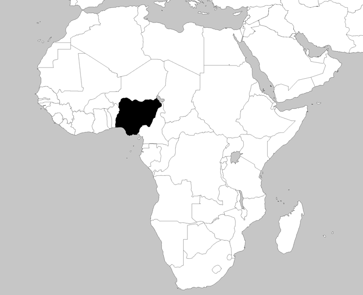
The city of Ibadan, founded in 1829, is the largest traditional urban centre in sub-Saharan Africa and represents the pinnacle of pre-colonial urban development in Nigeria. The city developed from what is now the core area, occupied by the early indigenous settlers (Figure 1). At present, this section of the city comprises the oldest and the lowest quality residences, as the buildings were constructed without any reference to building codes or standards.(19) Over the years, the pre-colonial city established on indigenous customs and traditions expanded, thereby integrating an outer region shaped by modern influences. A marked distinction exists between the traditional sections of the city and the newer areas as a result of the promulgation of the Town and Country Planning Ordinance by the British colonial authorities in 1946. The newer sections embraced to some degree planning interventions and development control.(20)
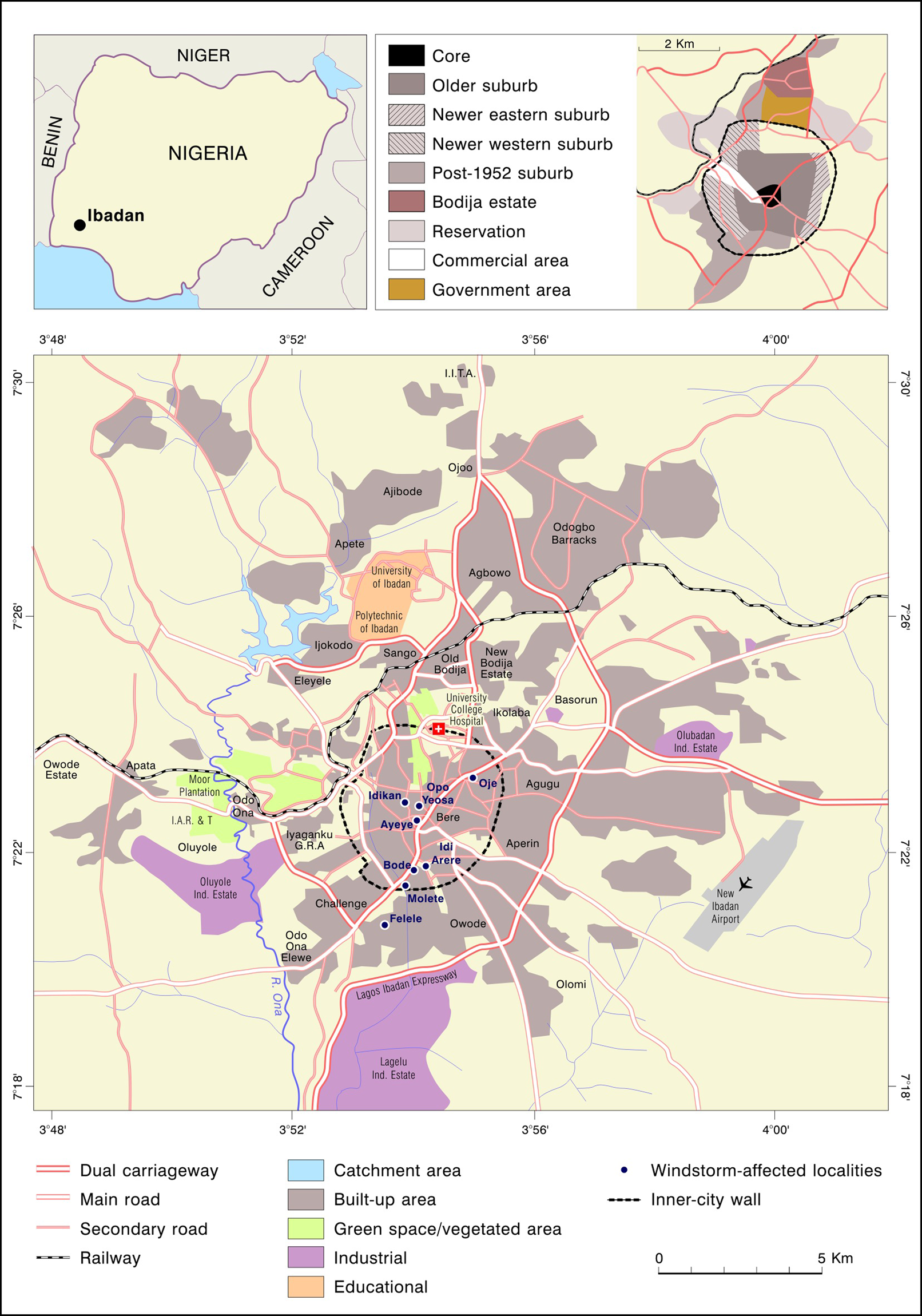
Windstorm-affected localities in Ibadan (2008)
According to the 2006 census, Ibadan metropolis, with about 828 persons per square kilometre, has one of the highest population densities in Nigeria. The designation of Ibadan in 1952 as the headquarters of the old Western Region of Nigeria (with an area measuring 114,271 square kilometres) contributed to rapid population growth and increased numbers of buildings to cater for the city’s political and economic activities. From a modest population of 70,000 inhabitants in 1856, the population of the city (otherwise known as Ibadan metropolis) had increased to 1.34 million by 2006 (Table 1), while the total population of Greater Ibadan was 2.55 million. Natural spaces surrounding houses in the traditional core area were built up to provide for more dwelling houses within traditional family compounds, as family units grew larger. This compound disintegration was largely a reflection of changes in the socioeconomic and cultural circumstances of the people.(21) About 26,254 housing units are located in the core area of the city.
Population growth of Ibadan city
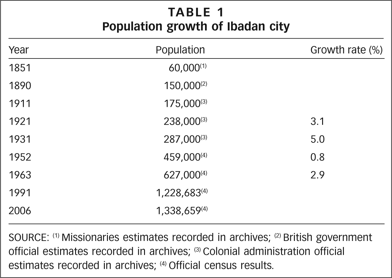
SOURCE: (1) Missionaries estimates recorded in archives; (2) British government official estimates recorded in archives; (3) Colonial administration official estimates recorded in archives; (4) Official census results.
Table 2 shows how land cover within Ibadan metropolis transformed significantly from the 1970s as a consequence of the rapid national economic development of the oil boom years. In 1972, vegetation accounted for 92 per cent of the total area of the city, while peri-urban development and the urban core occupied about 3.7 per cent and 3.0 per cent, respectively. The peri-urban developments were principally residential zones. A noteworthy feature of the city prior to 1972 was the absence of high density areas; however, by 1984, 11.42 square kilometres of the urban area was classified as high density and by 2003, the figure had risen to 64.8 square kilometres. The proportion of land with vegetation cover had reduced to 63 per cent by 1984 and to 39 per cent by 2003.
Key land use land cover (LULC) change in Ibadan (1972–2003)
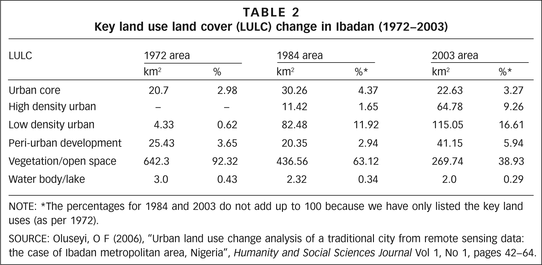
NOTE: *The percentages for 1984 and 2003 do not add up to 100 because we have only listed the key land uses (as per 1972).
A recent assessment of housing and environmental quality of representative high and medium density residential districts in Ibadan showed that about 72 per cent of houses in the inner-city core area were unfit for human habitation.(22) This is because toilet and bathing facilities, sewage disposal facilities, and potable water and electricity supplies were all lacking. Another 19 per cent were classified as sub-standard. In the medium density residential areas, 51 per cent of houses were considered either unfit for human habitation or sub-standard.
IV. Research Methods
The study is based largely on primary data obtained from the administration of a questionnaire and interviews conducted with 69 residents of windstorm-affected districts. In-depth interviews with key informants in urban planning institutions in the city were also conducted. Additional information was obtained from secondary sources such as local newspaper reports and other published documents. The occurrence and frequency of severe local winds with a threshold of 48 knots and categorized as windstorms on the Beaufort scale were also examined for the 20-year period 1989–2008. Analysis of monthly wind gust data for the city of Ibadan was done using data obtained from the Nigerian Meteorological Agency.
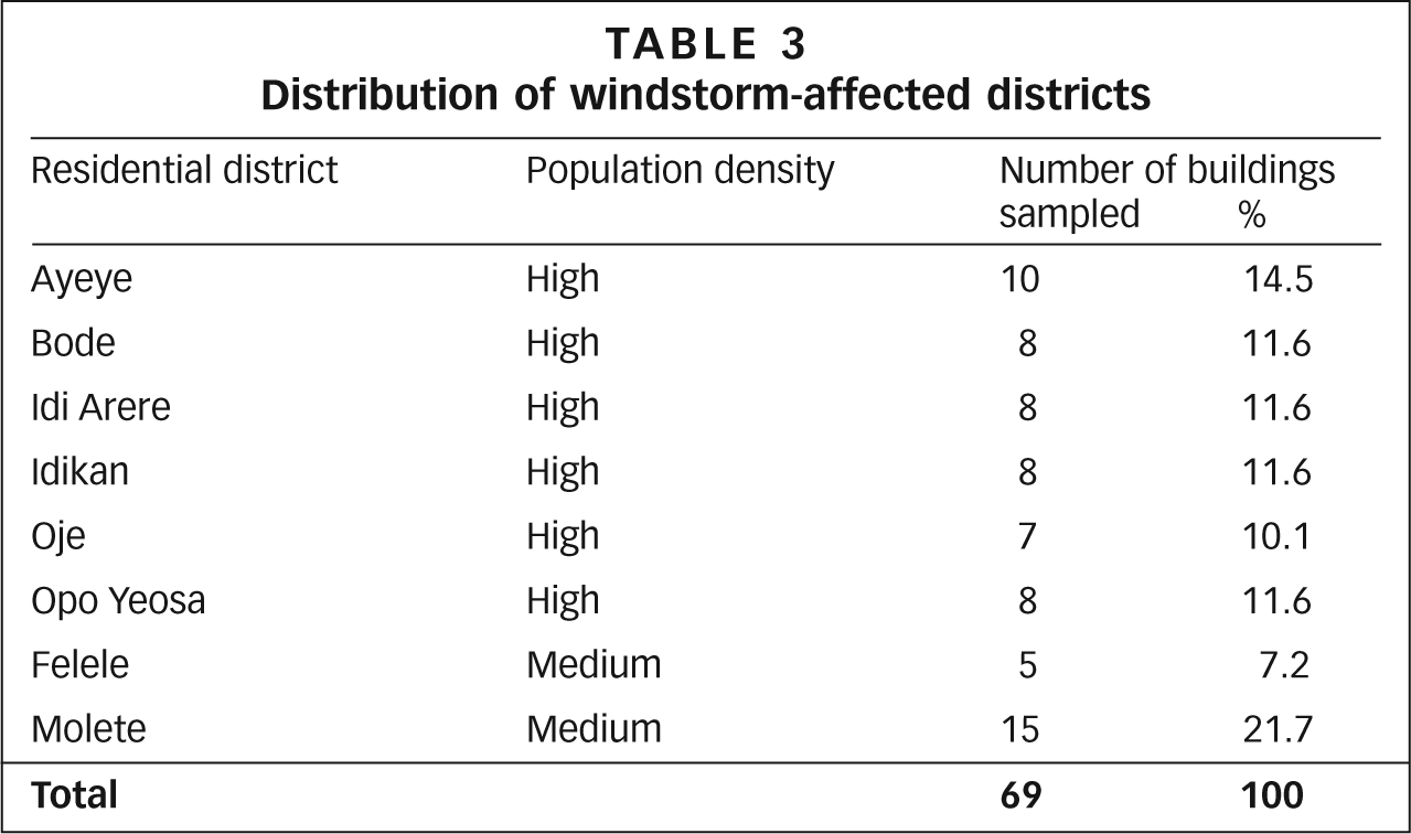
A survey of wind-damaged houses and affected residents following a severe windstorm event that occurred in March 2008 was done in June 2008. Districts affected by the windstorm event were identified and sampled based on local newspaper reports and identification by residents during a pre-study reconnaissance survey by two trained field assistants. Six of the eight affected districts are located in the high density traditional core area, while the remaining two, Felele and Molete, are situated in the older medium density areas of the city. Wind-damaged houses in the affected districts were identified by their wind-torn roofs, absence of roofs, broken walls and newly re-roofed sections of buildings. The identification of wind-damaged buildings was further confirmed by neighbourhood witnesses. The choice of affected buildings from which respondents were sampled for the administration of questionnaires was done randomly from as many streets as possible in each particular windstorm-affected district. This approach was adopted to ensure adequate spatial coverage of each residential district, and a total of 69 wind-damaged buildings were sampled in the eight identified districts (Table 3). The questionnaires were administered by two trained field assistants, and comprised semi-structured questions on household and socio-demographic characteristics of respondents, their past windstorm experience and their perception of the windstorm event, as well as the social and economic impacts of the windstorm event on the respondents’ households. Household and individual coping and recovery strategies were also examined, and for each building an adult resident who had good knowledge about the windstorm event was interviewed. Data collected from the completed questionnaire forms were analyzed using the Statistical Package for the Social Sciences (SPSS). The role of local institutions in the city with regard to urban sustainability and the reduction of vulnerability to climate risks was examined through in-depth interviews conducted with key personnel from the city’s planning authorities, including the Oyo State Urban and Regional Planning Board and the Sustainable Ibadan Project (SIP).
Distribution of windstorm-affected districts
V. Urban Vulnerabiity
The concept of vulnerability as applied to social systems has been interpreted as “…a set of conditions and processes resulting from physical, social, economic and environmental factors, which increase the susceptibility of a community to the impact of hazards.”(23) The significance of vulnerability with respect to effective planning for and response to hazards and other extreme events was highlighted by Sarewitz et al.,(24) who noted that the vulnerabilities associated with specific social and decision processes need to be well understood along with an understanding of the processes and probabilities of risk, in order for proper judgements to be made regarding effective management.
a. Maximum wind gust patterns (1989–2008)
Figure 2 shows the highest wind gust recorded each year from 1989 to 2008, and also shows that no windstorm event was recorded during the first 10 years, 1989–1998 (with the threshold for windstorms being 48 knots or more). The mean annual wind gust was 38 knots, with maximum wind events over the city varying from gale to strong gale. However, the mean annual wind gust for the period 1999 to 2008 was 46 knots, and 10 windstorm events were recorded during that period (Table 4). In 2000, a windstorm event with peak gusts of 52 knots was recorded, and since 2004, winds with peak gusts of 48 knots and above have become recurrent in the city, with each year recording at least one windstorm event (Table 4). The highest wind gust, measuring 60 knots, was recorded in 2005. The mean monthly maximum wind gust recorded for the months of February to November were also higher in the 10-year period 1999–2008 than for 1989–1998 (Figure 3). The difference in maximum wind events records for the two periods is statistically significant (Table 5). The observed pattern of increasing frequency of severe local winds in Ibadan city over the past decade has implications for climate risks within the city and underscores the emerging significance of windstorms as climatic hazards in the context of urban development. As described below, the severe windstorm event of March 2008 caused widespread physical damage to buildings and infrastructure, particularly in the inner core area of the city. This resulted in economic losses and social impacts for hundreds of residents in windstorm-affected areas; and the deaths of two young girls were reported after the windstorm brought the entire roof of a building about 20 metres away crashing down on them outside their home. The deaths of three children were also reported in Idikan district.
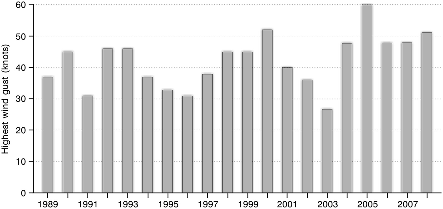
Annual maximum wind gust reports in Ibadan (1989–2008)
Windstorm events in Ibadan (1989–2008)
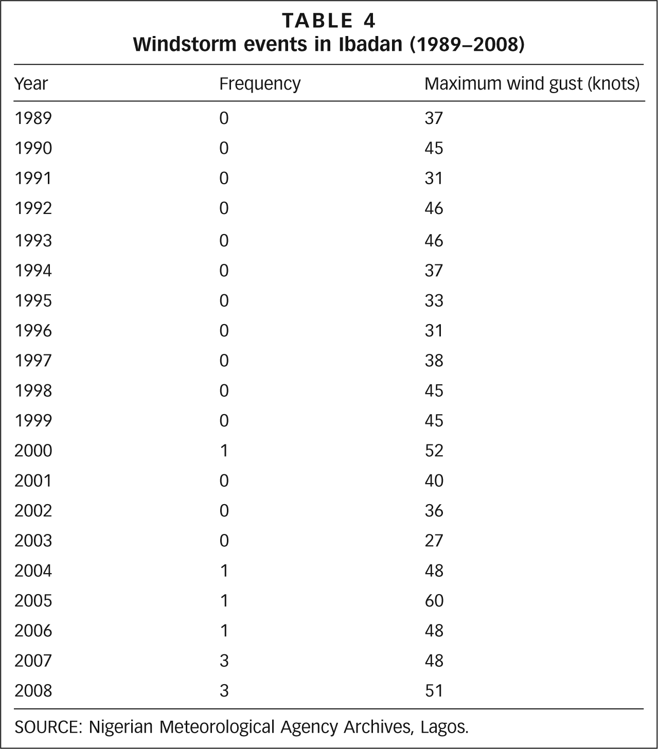
SOURCE: Nigerian Meteorological Agency Archives, Lagos.
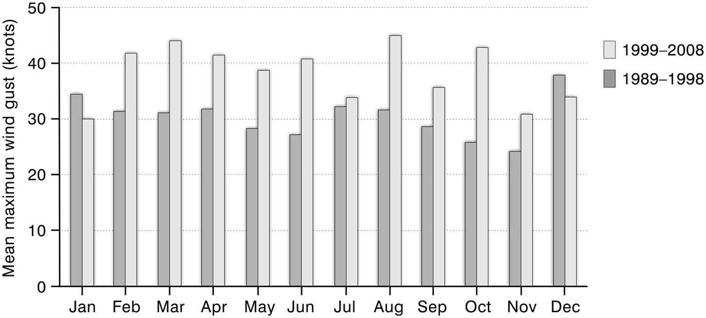
Variation in mean monthly maximum wind gusts
Results from the t-test (paired sample)
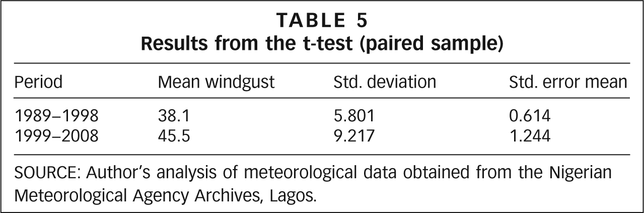
SOURCE: Author’s analysis of meteorological data obtained from the Nigerian Meteorological Agency Archives, Lagos.
b. Socioeconomic factors
The socioeconomic, household and housing characteristics of surveyed respondents that influence their vulnerability are described in this section. Forty-two (61 per cent) of the 69 respondents sampled were male and 27 (39 per cent) were female.
c. Windstorm-related damage and impact
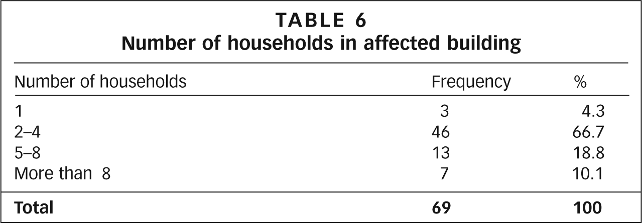
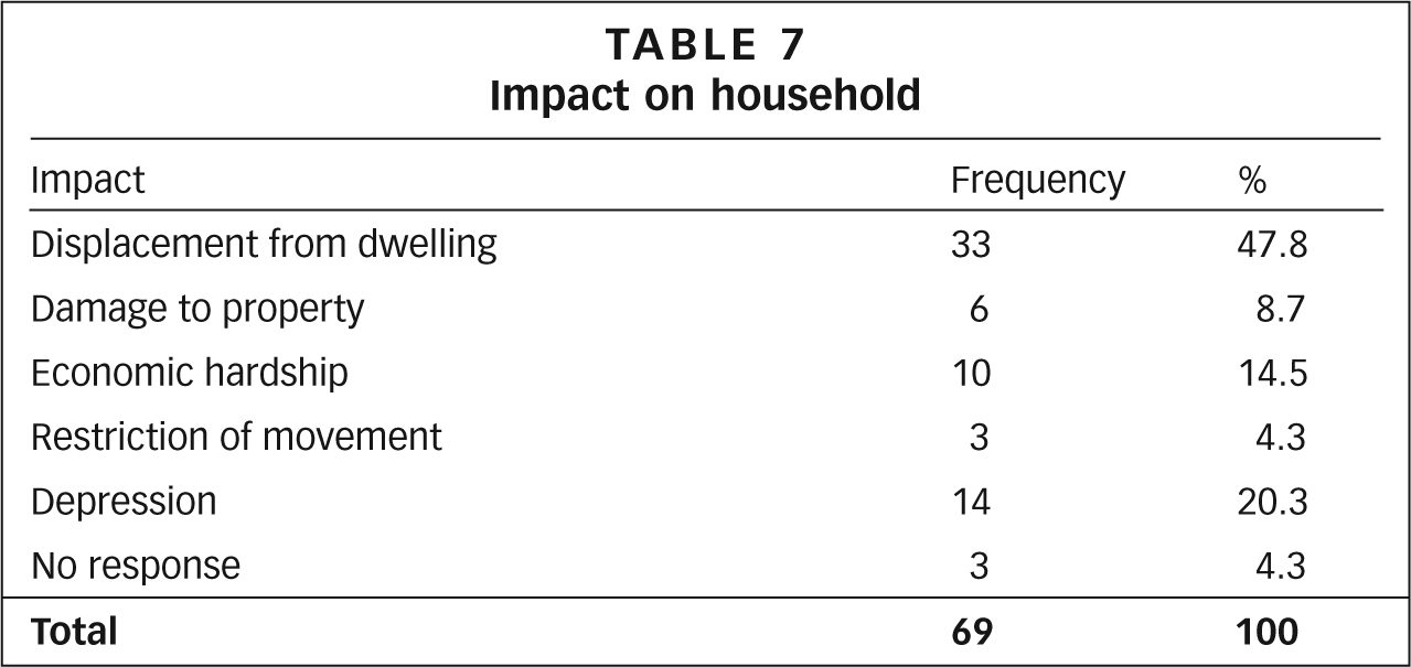
The impact of the windstorm event of March 2008 was considered to be severe because of the high concentration of residents in affected buildings. Most affected buildings (67 per cent) were occupied by two to four households, while 29 per cent had more than five households and only four per cent were occupied by one household (Table 6). Building type, configuration, condition, age and state of disrepair are all important factors influencing susceptibility to windstorm damage.(25) Wind impact resulted in partial or total damage to 87 per cent of sampled buildings, while 13 per cent suffered damage to both walls and roofs (Photo 1). Many one-storey buildings were damaged by falling rooftops blown off other multi-storey buildings. The loss of rooftops resulted in the displacement of 48 per cent of residents, as affected dwellings became exposed to the elements. Most households (81 per cent) incurred losses and damage to household property as a result of their exposure to the elements, especially rainfall. Those residing on the topmost floors of roof-torn multi-storey buildings and in damaged one-storey buildings were especially affected. Tenants and residents of family homes, who comprise the dominant group of residents in the study area (89.3 per cent), suffered losses from ensuing rainstorms. There was also the security dimension, as thieves seized the opportunity to steal household property in affected buildings. Other impacts of the windstorm event listed by respondents included economic hardship (15 per cent) and discouragement/depression (20 per cent) due to the disruption of their livelihood activities. Some could not leave their exposed houses to go to work for security reasons, while many others had to suspend their livelihood activities as their residences also served as the base of their economic activity (Table 7).
Number of households in affected building
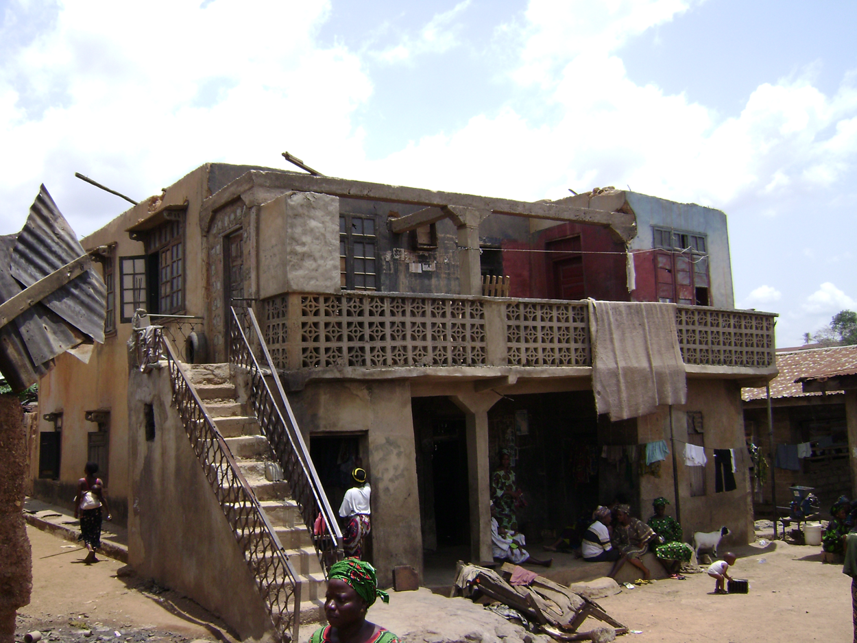
Wind-damaged building in the core area of the city, with its roof totally blown off
Impact on household
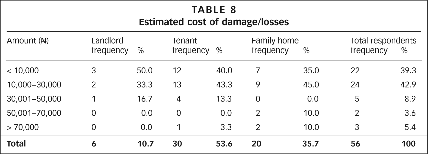
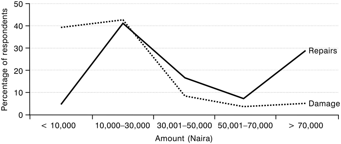
At the time of the survey, 78 per cent of sampled buildings had been repaired, albeit to varying degrees, while 22 per cent had yet to be repaired. The cost of repairs was borne by landlords (46 per cent), followed by family home residents (39 per cent). For many low-income households, losses exceeded their monthly income and therefore amounted to a huge drain on their economic state. The economic cost of the windstorm event on households was examined by asking respondents to estimate the amount that had been spent on effecting repairs to their dwellings and the value of property that had been lost. For 82.2 per cent of respondents, damage and property loss was estimated at not more than N30,000(26) (Table 8). The amount spent on repairs was directly proportional to the magnitude of loss and quality of roofing sheets used for repair works. In a number of cases, roof repairs were undertaken using roofing sheets that had been blown off in the windstorm; the cost of repairs was therefore relatively lower than the estimated cost of the damage, especially where this did not exceed N30,000. However, in cases where considerable damage was incurred, much more was spent on repairs. For example, more respondents (29.3 per cent) spent more than N70,000 on building repairs than the number whose damage had been estimated at no more than N70,000 (5.4 per cent), as shown in Figure 4. About 82 per cent of those who undertook building repairs spent less than N30,000, while fewer undertook repairs at a cost of between N30,000 and N70,000 (13 per cent), and more than N70,000 (5 per cent). Half of the respondents who spent less than N70,000 on building repairs were landlords, while 33.3 per cent of the same expenditure category were family home residents. Only about 17 per cent were tenants. This pattern is explained by the fact that tenants would not want to spend their resources on another person’s property.
Estimated cost of damage/losses
Relationship between the estimated cost of the damage incurred and the actual cost of repairs
d. Response and recovery measures
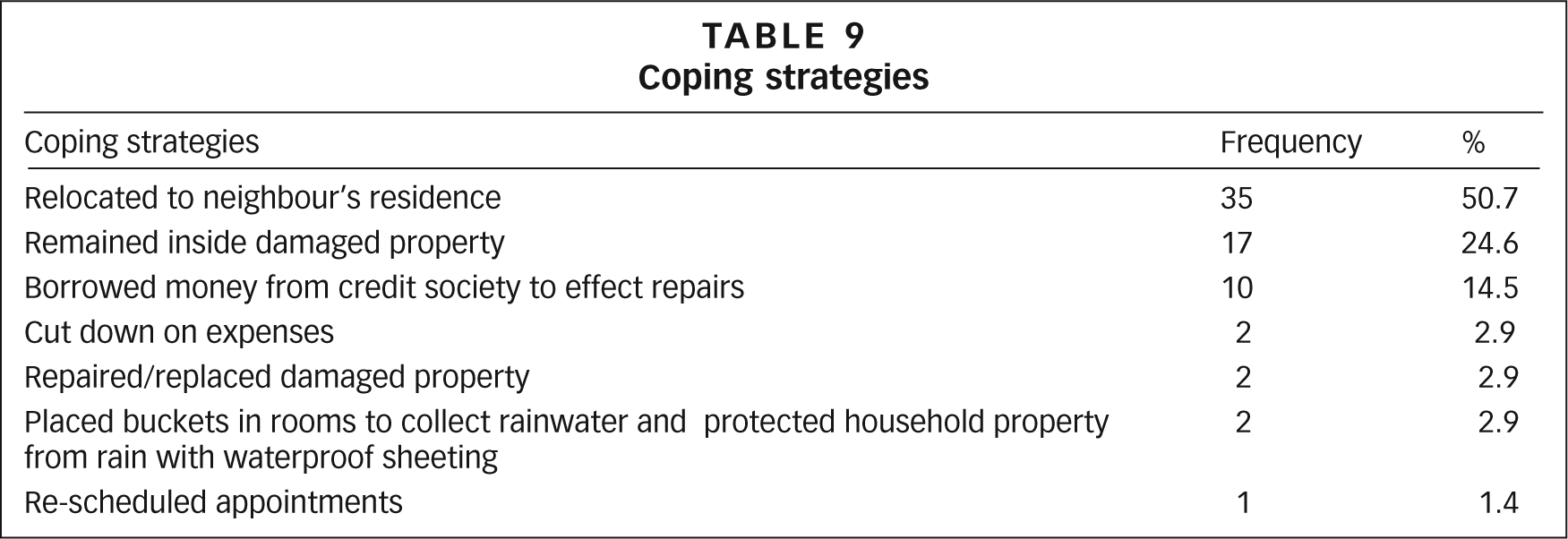
The effectiveness of responding to a disaster is considered to be a measure of the level of preparedness of a society.(27) The foremost coping strategy for about 50 per cent of respondents whose houses were damaged was to take refuge with family, neighbours and friends (Table 9). Family and kinship play an important role in the recovery process following a disaster event as they provide assistance to the affected through both emergency and temporary housing.(28) Others (25 per cent) stayed in the undamaged section of their dwelling, and some borrowed money from friends and social networks to fix the damaged parts of buildings (15 per cent). Other coping strategies included protecting household property with waterproof sheeting and placing buckets and containers in rooms to collect rainwater in the event of a future rainfall event.
Coping strategies
Repairs to affected buildings were undertaken by landlords (57 per cent) and tenants (15 per cent), and by family members (22 per cent) in cases where houses were either occupied by extended family members or were overseen by family. At the time of the survey, partial repairs involving re-roofing part of the buildings where residents could sleep and keep personal effects had been undertaken in four per cent of the damaged buildings. Thirty-seven per cent of respondents had completed repairs to damaged buildings within two weeks of the windstorm event, while 42 per cent had undertaken repairs within two to four weeks. Twenty-one per cent of wind-damaged buildings were not repaired until about two months after the event due to the inability to secure funds for repairs earlier. The majority of households (61 per cent) did not benefit from external assistance; of the 39 per cent who had assistance, in the form of gifts, moral support and cash, 56 per cent received these from family, friends and neighbours, 40 per cent from local government and four per cent from charitable organizations.
Government assistance was limited to the provision of building materials such as corrugated iron roofing sheets and nails for building repair works, while other materials, including wood planks, were provided by the people themselves. Nevertheless, some residential districts, particularly Idikan, Ayeye and Opo Yeosa, did not benefit from government assistance. In Ayeye, for example, most wind-damaged houses had yet to be re-roofed three months after the event, as residents waited for assistance from local government or charitable organizations. However, government or donor assistance was not assured; it may not be given at all, and when it is it may be poorly targeted or given on an ad hoc basis.(29) Respondents from these districts were of the opinion that districts that received support from government were favoured because of political and familial affiliations with the deputy governor of the state, who hailed from one of the compounds in the favoured districts. This assertion by respondents was documented more generally by Quarantelli,(30) who observed that disaster recovery assistance, in many situations either at the domestic or foreign level, is strongly affected by political considerations since help is sometimes given primarily, or at least earlier, to supporters of the political party in power. The political affiliations of vulnerable groups may therefore be a factor in their recovery process.
e. Risk perception
Risk perception is an important determinant of vulnerability, as it is associated significantly with disaster preparedness. If the risk of a damaging event is perceived to be relatively high, there is a greater probability of investment in loss reduction or preventive measures.(31) Past experience may raise an individual’s perception of risk to a level where he or she feels that it is a problem worthy of attention. Respondents’ perception of windstorms as a risk or threat in the surveyed areas is considered to be low, as the majority (80 per cent) indicated no previous experience of severe wind events. Of the remaining respondents with past experience of windstorms, only three per cent had experienced them during the period 1949–2005, while 64.3 per cent indicated that their experience had been within the previous three years. Some in this category were from Idi Arere, Molete and Bode in the high density core area of the city. This further confirms that windstorms are a recent phenomenon in the city.
More than one-third of respondents (35 per cent) couldn’t offer any reasons for the damage caused by the windstorm. Twenty-six per cent were of the opinion that damage to the buildings was due to their age, while 32 per cent saw the strength of the windstorm as the principal cause. Other causative factors suggested included sin, the absence of trees in the environment and poor quality construction materials. More than half of respondents doubted the possibility of a recurrence of a windstorm event of such magnitude in the near future, while 39 per cent thought that such an event could re-occur and nine per cent were uncertain. A small percentage of respondents (nine per cent) were of the opinion that a windstorm of such magnitude was natural, and hence nothing could be done to prevent or adapt to future events. These more fatalistic perceptions tend to hinder the embracing of prevention and adaptation measures.(32) Nor are they peculiar to traditional societies, as shown in an investigation of the perception of flood, windstorm and earthquake risks by residents of six hazard-prone communities in Germany, who conceived of disasters as inevitable events.(33) Because of limited possibilities to prepare and respond, residents would perceive risks as high even when the consequences might not be particularly disastrous.
f. Adaptation strategies
Adaptation measures suggested by respondents included retrofitting of roofs (33 per cent) and regular renovation/maintenance of buildings (29 per cent); the use of good quality and long-lasting construction materials was also mentioned (16 per cent). Prayer was considered to be the best option by 70 per cent of respondents, who felt that the windstorm event was an act of God/result of sin and therefore required spiritual intervention. The adoption of prayer by people affected by hydro-meteorological disasters has been recorded elsewhere, for example in Bangladesh, Peninsular Malaysia and New Zealand.(34) Prayer was the most frequent precautionary measure taken by more than 70 per cent of residents in two communities struck by a cyclone in Bangladesh.
g. Mitigating losses through insurance
Insurance is acknowledged as an important climate risk management tool for reducing present and future social vulnerability linked to climate change and to aid short-term recovery.(35) For low-income countries that are highly vulnerable to the impacts of climate hazards due to their low adaptive capacity, climate insurance is especially important.(36) Access to insurance markets for climate-related risks is, however, very low or non-existent in many developing countries, unlike in more developed societies where insurance is a viable mitigating measure for enhancing adaptive capacity against the impacts of climate change.(37) Virtually all wind-damaged buildings (93 per cent) in the affected districts were known to be uninsured. Some tenants did not know the insurance status of their dwellings and only one respondent claimed that his building was insured against natural events. It has been noted in other contexts that because individuals underestimate the losses and/or probability of a disaster, the benefits of insurance protection appear unattractive relative to the cost of the policy or the premium on a policy.(38) A large percentage of respondents (59 per cent) did not consider insurance a smart mitigation measure against future windstorm hazards because of their lack of confidence in insurance firms. They also felt that insurance premiums were too high considering the current economic value of wind-damaged buildings and the economic status of building owners.
VI. Implications of Urban Development for Future Vulnerability Patterns
A major area of settlement for those relocating from the inner core of the city is the eastern side of the core area where land is owned by indigenous communities and families. In these newly developing areas, development is progressing without adherence to planning regulations or building codes, and planning authorities do little to exercise any control. In many cases, buildings are partially roofed or not properly fitted before being occupied by those seeking to escape the high rents and slum conditions of the core area. As Chokor observes:
“The core indigenous city continues to maintain the character of its urbanism by expanding eastwards away from the largely immigrant suburbs to the west and north and, by refusing to adhere to planning prescriptions, recent developments create a further fragmentation of Ibadan’s urban growth.”(39)
This observation is also valid with respect to the spatial extension of urban vulnerability to wind hazards in Ibadan. These areas are therefore vulnerable because of their population characteristics, which are not much different from those of residents in the core of the city, and because of non-compliance with urban development and planning regulations, and not because of their spatial location or climatic risk. The path of urban development and ineffective urban planning is, therefore, a significant factor influencing potential vulnerability to wind hazards in sections of the city, even when these districts are not situated in geographically hazardous terrain.(40)
VII. The Role of Local Institutions
Small-scale weather events are barely acknowledged at the national level in Nigeria. This is evident from the content of two recent national documents developed to provide a framework for disaster risk reduction in Nigeria,(41) which made minimal reference to the risks resulting from windstorms. Nonetheless, as reports in some Nigerian daily newspapers indicate, windstorms are becoming increasingly important risks in Nigerian urban centres. The onus invariably rests heavily on cities’ municipal and local governments to plan towards managing future hazard events. In Nigeria, in most cases, local planning authorities lack the skills and expertise that are increasingly required for effective urban development planning and management. In the five local government areas comprising urban Ibadan, the authorities with responsibility for enforcing planning regulations and building codes do not function effectively. Poor remuneration causes poor work morale among staff, and there is a lack of tools for monitoring urban development that results in a gap between the current level of operation and what should be done by local institutions to address climate change. The Urban and Regional Planning Board, for instance, does not consider present and possible future climate conditions in its physical planning. There has been no hazard mapping of the city to date. Although an attempt was made to undertake flood hazard mapping in 1983 after some noteworthy flood events, none is currently available. Nor do standards and policy formulation take into consideration local changes in hazard exposure and the spatial distribution of vulnerability, because the relevant information is not available to planners and policy makers. Although emerging patterns of environmental change place new demands on urban planners, training and capacity building on climate change do not feature in the country’s national curriculum for urban and regional planners.
The city of Ibadan is, nevertheless, not without structures that may be organized to respond to climate change. One example is the Sustainable Ibadan Project (SIP), a long-term strategic initiative for sustainable development planning of the city launched in 1994 with support from UNCHS/UN–Habitat. SIP focuses on three cross-cutting environmental issues: sanitation, health and solid waste management; health and water supply; and institutional arrangements for improved solid waste and water supply management. SIP’s major shortcoming is the non-inclusion of the management of climate risks. An appreciation of the fact that making cities more sustainable requires the integration of adaptation responses would help the project to accomplish its goals more adequately. This may, however, be a challenge to a society whose risk management approach is more reactive than proactive. Another institutional structure is the Urban and Regional Planning Board (URPB), established in 2008 with the mandate to plan strategically for Oyo state and to produce development plans for cities within the state. Although at present the URPB has no programme to address and plan for climate risks in Ibadan, a step in the right direction is the recent introduction of a new service requiring every building plan (commercial or residential) to have a site analysis report before being approved. This is likely to enforce consideration of local wind characteristics, including direction, in the location of structures. The proposed renewal of the core area of the city also presents an opportunity to address the vulnerability of indigenous populations through the improvement of their social conditions.
In line with the international agenda, Nigeria has developed a National Action Plan for Disaster Risk Reduction for the country with the National Emergency Management Agency (NEMA) as the focal agency on disaster risk reduction. To date, however, a myriad of challenges face the development and implementation of the plan. Key among the challenges are the lack of political will and insufficient commitment to disaster risk reduction at state and local levels. The lack of cooperation between NEMA and state agencies is also a major hindrance to progress. This is clearly the case for Ibadan, as little or no collaboration exists between relevant agencies and stakeholders in the city that could work together to respond to climate risks and enhance urban sustainability. This is exemplified by the present lack of collaboration between the State Emergency Management Agency and the URPB. This lack of collaboration between relevant agencies is not peculiar to Nigeria. For example in Senegal, institutional coordination has been identified as a major challenge to the ex-ante disaster risk management efforts for the city of Dakar.(42)
VIII. Reducing Vulnerability: Local Institutions and Urban Sustainability
Urban planning is considered to be one of the key entry points for climate change mitigation and adaptation in cities.(43) The legal framework within which local planning authorities operate as well as the general planning process make them an ideal institutional body for managing global change outcomes.(44) Furthermore, local authorities are considered to be in a position to be conversant with local disaster risks. Empirical evidence establishing the legitimacy of local planning as an effective community-based tool for climate management was provided using a sample of central cities in contiguous states in the USA.(45) Nevertheless, the obvious advantages of protecting the public good through effective urban planning have not sufficiently motivated developing countries, particularly at the local government level, to make limited investment to ensure basic standards for the activities they implement.(46)
At the global level, a number of initiatives have been developed to assist cities and communities build resilience to the impacts of climate hazards and disasters. The Hyogo Framework for Action (HFA) 2005–2015: Building the Resilience of Nations and Communities to Disasters, which was adopted by member states of the United Nations in 2005, is the flagship of recent initiatives. With the overarching goal of promoting a strategic and systematic approach to reducing vulnerabilities to disasters and hazard risks in communities, the framework highlights five approaches to disaster risk management. In particular, the HFA advocates that national and local priority be given to disaster risk reduction, with a strong institutional framework for implementation. A follow-up initiative to the HFA is the Incheon Declaration, with the aim of localizing the HFA through an alliance of local governments for disaster risk reduction.(47) The Incheon Declaration acknowledges that local governments must become the drivers of adaptation and mitigation strategies that will result in greatly reduced disaster risk and loss potential. The Incheon Declaration is considered to be especially relevant to developing countries since it is at the local level that most pressure from the stresses and strains of rapid urbanization is felt. Other initiatives reflecting the growing interest in climate change in cities include the UN–Habitat Resolution on Cities and Climate Change, the International Council for Local Environmental Initiatives (ICLEI) and the more recent UN–ISDR Making Cities Resilient Campaign, inaugurated in Davos in June 2010.
For local institutions in Nigeria’s urban centres to respond effectively to the new pattern of climate risks arising from increasing frequency and intensity of extreme climate events and also to the emerging vulnerability resulting from urban development patterns, strong commitment is required on the part of local institutions to domesticate the international initiatives in line with their local experiences.
IX. Conclusions
African urban centres are considered to be especially vulnerable to natural hazards and extreme weather events because of the low adaptive capacity of their populations and the deficits in infrastructure.(48) Rapid urban growth, unplanned urban development and the changing urban forms of African cities in the context of increasing frequency and intensity of extreme weather provide the conditions for natural events, including severe local winds, to become disastrous. Vulnerability to windstorm hazards is high in the core areas of Ibadan, a traditional city setting characterized by poor quality and poorly maintained housing, occupied mostly by indigenous populations of low socioeconomic status. The aged and deteriorating nature of the buildings and infrastructure in the affected sections of the city also exacerbate the vulnerability of residents. The risk perception of residents of the city’s core area in relation to severe winds, along with changes in the socioeconomic and environmental characteristics of study populations over time, also contribute to their low adaptive capacity to this small-scale hazard event.(49)
The institutional context of urban development and the public’s disdain and apathy towards the city’s local planning authorities that has emerged since the 1950s and that still exists, together with the low socioeconomic status and the poverty levels of indigenous, inner-city residents all contribute to residents low adaptive capacity.(50)
With the probability of increased frequency of stronger local wind events in the future as a result of climate change, urban vulnerability to wind hazards, especially in traditional cities, will increase unless decisive action is taken to mainstream a consideration of climate and vulnerability profiles of urban centres within urban development and planning. For many African cities, a review of existing codes for the design and construction of buildings and rooftops is required, which take into account changing patterns of maximum wind gusts. Measures for climate change mitigation and adaptation in urban centres and responsive institutional structures are also needed in order to manage the new patterns of climate risks.
Footnotes
Acknowledgements
The author is grateful to the anonymous reviewers and the editors for their comments and constructive suggestions, which have greatly enhanced the quality of this paper. An initial version of the paper was presented at the International Conference on Urbanization and Global Environmental Change, Tempe, Arizona, 15–17 October 2010.
1.
Parry, M L, O F Canziani, J P Palutikof, P J van der Linden and C E Hanson (editors) (2007), Climate Change 2007: Impacts, Adaptation and Vulnerability. Contribution of Working Group II to the Fourth Assessment Report of the Intergovernmental Panel on Climate Change, Cambridge University Press, Cambridge, 976 pages.
2.
See reference 1; also Etkin, D (1999), “Risk transference and related trends: driving forces towards more mega-disasters”, Environmental Hazards Vol 1, pages 69–75; and Mirza, M M Q (2003), “Climate change and extreme weather events: can developing countries adapt?”, Climate Policy Vol 3, pages 233–248.
3.
See reference 1.
4.
Seto, K C and J M Marshall (2009), “Global urban land use trends and climate impacts”, Current Opinion in Environmental Sustainability Vol 1, pages 89–95.
5
Sarewitz, D, R Pielke and M Keykhah (2003), “Vulnerability and risk: some thoughts from a political and policy perspective”, Risk Analysis Vol 23, No 4, pages 805–810.
6.
Simon, D (2010), “The challenges of global environmental change for urban Africa”, Urban Forum Vol 21, pages 235–248.
7.
Parnell, S, D Simon and C Vogel (2007), “Global environmental change: conceptualizing the growing challenge for cities in poor countries”, Area Vol 39, No 3, pages 357–369.
8.
9.
Marulanda, M C, O D Cardona and A H Barbat (2009), “Revealing the socioeconomic impact of small disasters in Colombia using the DesInventar database”, Disasters Vol 34, No 2, pages 552–570.
10.
Dale, V H et al. (2001), “Climate change and forest disturbances”, BioScience Vol 51, No 9, pages 723–734.
11.
Kasperson, J X, R E Kasperson and B L Turner (1995), Regions at Risk: Comparison of Threatened Environments, United Nations University Press, Washington DC; also ![]() , “Disaster risk: conditions, trends and impacts”, in Global Report on Human Settlements 2007 – Enhancing Urban Safety and Security, Earthscan, London, pages 167–194.
, “Disaster risk: conditions, trends and impacts”, in Global Report on Human Settlements 2007 – Enhancing Urban Safety and Security, Earthscan, London, pages 167–194.
12.
Coleman, T (2002), “The impact of climate change on insurance against catastrophes”, Insurance Australia Group, Melbourne, Australia, 12 pages.
13.
Spence, R J S, W H Fawcett and A J Brown (1998), “The windstorm vulnerability of the UK building stock”, Proceedings of the 4th UK Conference on Wind Engineering, Bristol, 2–4 September 1998; also Blackmore, P and E Tsokri (2004), “Windstorm damage to buildings and structures in the UK during 2002”, Weather Vol 59, No 12, pages 336–339; Nadimpalli, K, R P Cechet and M Edwards (2007), “Severe wind gust risk for Australian capital cities: a national risk assessment approach”, 7 pages; and Tamura, Y and S Cao (2009), “Climate change and wind-related disaster reduction”, available at ![]() .
.
14.
Adelekan, I O (2000), “A survey of rainstorms as weather hazards in southern Nigeria”, The Environmentalist Vol 20, pages 33–39; also Goliger, A M and J V Retief (2007), “Severe wind phenomena in Southern Africa and the related damage”, Journal of Wind Engineering and Industrial Aerodynamics Vol 95, No 9–11, pages 1065–1078.
15.
Hamilton, R A and J W Archbold (1945), “Meteorology of Nigeria and adjacent territory”, Quarterly J. Roy. Met. Soc. Vol 71, pages 231–264; also Eldridge, R H (1957), “A synoptic study of West African disturbance lines”, Quarterly J. Roy. Met. Soc. Vol 83, pages 303–314.
16.
Soboyejo, A B O (1971), “Distribution of extreme winds in Nigeria”, The Nigerian Engineer Vol 7, No 3, pages 21–34; also Ayoade, J O (1980), “A note on spatial and seasonal variations in wind speed over Nigeria”, Singapore Journal of Tropical Geography Vol 1, No 2, pages 11–15; and Fagbenle, R L and T G Karayiannis (1994), “On the wind energy resource of Nigeria”, Int. J. of Energy Research Vol 18, pages 493–508.
19.
Arimah, B C and D Adeagbo (2000), “Compliance with urban development and planning regulations in Ibadan, Nigeria”, Habitat International Vol 24, pages 279–294.
20.
Chokor, B A (1986), “City profile – Ibadan”, Cities Vol 3, pages 106–116.
21.
Ayeni, B (1994), “The metropolitan area of Ibadan: its growth and structure”, in M O Filani, F O Akintola and C O Ikporukpo (editors), Ibadan Region, Rex Charles Publication, Ibadan, pages 72–84; also Chokor, B A (2005), “Changing urban housing form and organization in Nigeria: lessons for community planning”, Planning Perspectives Vol 20, pages 69–96.
22.
Coker, A O, O S Awokola, P O Olomolaiye and C A Booth (2008), “Challenges of urban housing quality and its associations with neighbourhood environments: insights and experiences of Ibadan city, Nigeria”, Journal of Environmental Health Research Vol 7, No 1, pages 21–30.
23.
UN–ISDR (2002), “Disaster reduction and sustainable development: understanding the links between vulnerability and risk related to development and environment”, Background Document for the World Summit on Sustainable Development, available at ![]() , page 21.
, page 21.
24.
See reference 5.
26.
US$ 1 is approximately Naira (N) 150.
27.
See reference 5.
28.
Bolin, R C (1982), Long-term Family Recovery from Disaster, Institute of Behavioural Science, University of Colorado, Monograph 36, Boulder, Colorado, 278 pages; also Quarantelli, E L (1999), “The disaster recovery process: what we know and do not know from research”, Preliminary Paper No 286, Disaster Research Centre, University of Delaware, 19 pages.
29.
Arnold, M (2008), “The role of risk transfer and insurance in disaster risk reduction”, available at ![]() .
.
30.
See reference 28, Quarantelli (1999).
31.
Kunreuther, H (1997), “Rethinking society’s management of catastrophic risks”, The Geneva Papers on Risk and Insurance Vol 22, No 83, pages 151–176; also see reference 2, ![]() .
.
32.
Weichselgartner, J and J Bertens (2000), “Natural disasters: acts of God, Nature or Society? On the social relation to natural hazards”, in M A Andretta (editor), Risk Analysis II, WIT Press, Southampton, pages 3–12.
33.
Plapp, T and U Werner (2006), “Understanding risk perception from natural hazards: examples from Germany”, in W Amman, S Dannenmann and L Vulliet (editors), Proceedings of the RISK 21 – Coping with Risks due to Natural Hazards in the 21st Century, Ascona, Switzerland, 28 November–3 December 2004, pages 101–108.
34.
Haque, C E and D Blair (1992), “Vulnerability to tropical cyclones: evidence from the April 1991 cyclone in coastal Bangladesh”, Disasters Vol 16, pages 217–229; also Chen, N W and D J Parker (1996), “Response to dynamic flood hazard factors in Peninsular Malaysia”, The Geograpical Journal Vol 162, No 3, pages 313–325; and Gregory, G and A Loveridge (1997), “Social and cultural aspects of natural hazards perception and response”, New Zealand Geographer Vol 53, No 1, pages 47–54.
35.
See reference 31, Kunreuther (1997); also Mills, E (2007), “Synergisms between climate change mitigation and adaptation: an insurance perspective”, Mitig Adapt Strat Glob Change Vol 12, pages 809–842.
36.
DFID (2004), “Adaptation to climate change: can insurance reduce the vulnerability of the poor?”, Key Sheet 8, Department for International Development, London, available at http://www.dfid.gov.uk/pubs/files/climatechange/keysheetsindex.asp, 8 pages; also Park, J (2005), “Enhancing security, reducing vulnerabilities: climate change and financial innovation”, Paper presented at Human Security and Climate Change Workshop, Asker, 21–23 June 2005, accessed 16 June 2010 at http://www.gechs.org/downloads/holmen/Park.pdf; and see reference 35, ![]() .
.
37.
See reference 29.
38.
Kunreuther, H (1984), “Causes of under-insurance against natural disasters”, The Geneva Papers on Risk and Insurance Vol 9, No 31, pages 206–220; also Kunreuther, H (1996), “Mitigating disaster losses through insurance”, Journal of Risk and Uncertainty Vol 12, pages 171–187.
39.
See reference 20, page 113.
40.
Chakraborty, J, G A Tobin and B E Montz (2005), “Population evacuation: assessing spatial variability in geophysical risk and social vulnerability to natural hazards”, Natural Hazards Review Vol 6, No 1, February, pages 23–33.
41.
42.
Trohanis, Z, F Shah and F Ranghieri (2009), “Building climate and disaster resilience into city planning and management processes”, Paper presented at the Fifth Urban Research Symposium on Cities and Climate Change, Marseilles, France, July 2009, 17 pages.
43.
See reference 2, Etkin (1999); also Wamsler, C, S Huq, S Kovats, H Reid and D Satterthwaite (2007), “Reducing risks to cities from disasters and climate change”, Environment and Urbanization Vol 19, No 1, April, pages 3–15.
44.
Burby, R J (1999), “Unleashing the power of planning to create disaster-resistant communities”, Journal of the American Planning Association Vol 65, No 3, pages 247–258; also UN–ISDR (2004), “Living with risk: a global review of disaster reduction initiatives”, United Nations, Geneva, available at http://www.unisdr.org/eng/about_isdr/bd-lwr-2004-eng.htm; Pelling, M and B Wisner (2008), “Urbanization, human security and disaster risk in Africa”, in M Pelling et al. (editors), Disaster Risk Reduction: Cases from Urban Africa, Earthscan, UK, pages 3–16; and Grover, H (2008), “Global impressions with local planning: managing environmental change”, Paper presented at UNU–EHS Summer Academy, 21 pages.
46.
Simon, D (2007), “Cities and global environmental change: exploring the links”, The Geogaphical Journal Vol 17, No 3, pages 75–79.
47.
UN–ISDR (2009), “Building a local government alliance for disaster risk reduction: ‘The Incheon Declaration’”, United Nations, Geneva, available at ![]() .
.
48.
World Bank–IEG (2007), “Disasters, climate change and economic development in sub-Saharan Africa; lessons and future directions”, available at http://worldbank.org/ieg; also Hope Snr, K R (2009), “Climate change and urban development in Africa”, Int. J. Environmental Studies Vol 66, No 5, pages 643–658.
49.
Romero Lankao, P and H Qin (2011), “Conceptualizing urban vulnerability to global climate and environmental change”, Current Opinion in Environmental Sustainability Vol 3, No 3, pages 142–149.
50.
See reference 19.