
Abstract
This narrative of governance and land issues in Mpasatia, a small traditional town in the Ashanti region of, Ghana focuses on the first “modern” plot sub-division project in the town, initiated in 1993. Land has always been a subject of interest in Ghana due to the belief that it belongs to three sets of people, namely the ancestors, those living now and future generations. This conceptualization provides some explanation of how land is delivered for development and how it complicates local governance of land, including land revenue, and also the difficulties associated with traditional settlements copying new urban development in cities like Kumasi. The paper discusses how the model of modernization of new sub-divisions was adopted in the Nkwanta Scheme within Mpasatia, reflecting the radical change seen over the last two decades in Kumasi and Accra, where recent developments have abandoned smaller plots for compound houses, providing big plots for detached villas. The paper provides possible reasons for the limited success of the scheme.
I. Introduction to mpasatia
Mpasatia is a small traditional town in the Ashanti region, 35 kilometres west of Kumasi, with nearly 8,000 inhabitants.(1) The residents prefer to call it a “traditional town”: “traditional” because it was founded centuries ago and because descendants, wherever they live, will ultimately return to live and be buried there – and least this is how it was and how local leaders like to conceive it; and “town” because “village” has negative connotations, referring to poor, outlying hamlets, and indeed Mpasatia’s inhabitants live in a concentrated urban-like settlement. The majority make their living from subsistence farming on the relatively fertile land around the town and a few commute to work in Kumasi, although the distance is quite prohibitive. Almost one-third of household heads are migrants, many from the north. Growth is very slow, perhaps in some years even negative. Most residents have modest or very modest incomes; 75 per cent of households have only one room and many are renters; 47 per cent have no electricity; and there are but a handful of private cars in the town.(2)
There is some degree of ethnic spatial division, with the so-called Zongo area, which in most Ghanaian urban centres accommodates migrants, a majority of whom are from the northern parts of Ghana. There is, however, no social difference between the town areas. In fact, the poorest live in the central area planned and developed in the 1920s, where we also find the Chief’s “palace”. The town has a central elongated square, where the main road from Kumasi to the west once went through. Here we find shops and stalls, the first church, residents playing draughts, and bus and taxi stands. Some trees remain from a “beautification campaign” in the 1970s and flowerbeds were recently refurbished. A new market was opened here in 2010, financed by the District Assembly, and this is also where the few public meetings are held, mostly government public announcements.
Some residents suggest that there are problems with the youth, not least due to limited access to employment. However, a common sentiment is that Mpasatia, unlike many other places, is very peaceful. In general, people express trust in their leaders.
Ii. Local governance
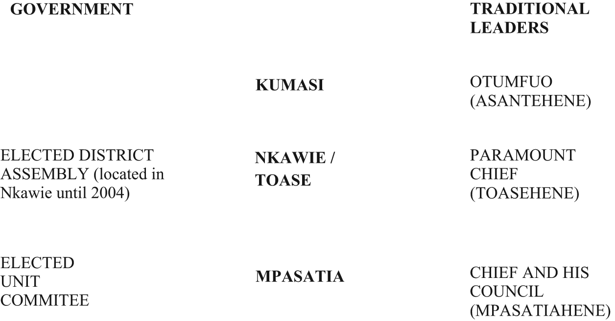
Local governance in Mpasatia, as in Ghana in general, is characterized by shared or joint governance by the government and traditional leaders. For 100 years, this has been the cause of many conflicts. The actors interviewed in Mpasatia include first and foremost the traditional leaders, with the late Chief (the “Mpasatiahene”(3) owing allegiance to the Paramount Chief (the “Toasehene”(4) in the nearby settlement of Toase in the small town of Nkawie, and ultimately to the “Asantehene” (also referred to as the “Otumfuo”) in Kumasi. Local clan chiefs are also influential, particularly Nana Ketehene.(5) The Chief is supported by a council that includes the chairman of the Land Allocation Committee (who died in 2010). The formal government system in Mpasatia includes a Unit Committee, and there are two assemblymen elected to the former Atwima District Assembly in Nkawie.(6) Decision-making in Mpasatia, however, is largely in the hands of the Chief. In fact, the democratically elected Unit Committee (earlier termed the Town Development Committee) functions as the Chief’s executive body.
Most of these actors were involved in the town’s biggest endeavour to develop a modern town, namely a project to provide new plots along lines more commonly seen in Kumasi, which involved changing a largely communitarian delivery of land to one based on commodity relations. In the following section we explain the origins of the peculiar local form of land tenure, and although we refer to the Ashanti region, many of these tenure characteristics are shared by other regions in Ghana.
The political system in and around Mpasatia
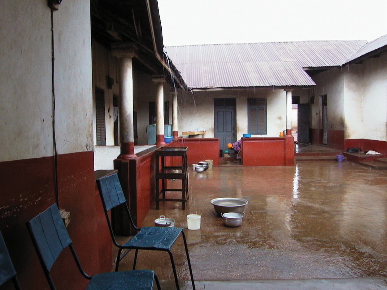
The Chief’s “palace” – the building is similar to most houses in Mpasatia
Iii. Some notes on land history
Traditionally, land is characterized as community property (owned by the dead, the living and future generations) while simultaneously having the status of a commodity. Although plots are still officially freely allocated for use, in reality they are also paid for. The Chief’s power is closely associated with his control over land, particularly with the question of who is entitled to command the revenue. The origins of this situation date back to before 1900. Konadu-Agyemang explains that the present land issue is rooted in old traditions. He suggests that in the case of Kumasi, “. . .people’s attitude to traditions, customs and beliefs regarding land ownership and the role of the spirits of dead ancestors in the affairs of the living may in effect be safeguarding the city against the development of squatter settlements.”(7)
Chief’s house with a bamaso – a concrete bench. The new Chief’s house is on the left
British intervention in land issues during the colonial era accepted the notion that chiefs held or owned the land as trustees for their people.(8) Regulation of “stool” property(9)was strict, particularly in Ashanti, but substantial parts of the revenue found their way directly into the private purses of the chiefs. The British tried in vain to establish a system that ensured that the bulk of the income was fairly used for the community and that an appropriate allowance was paid to the Chief.(10)
The first government after Independence tried hard to take control of the nation’s resources for development purposes. In 1958, just after Independence, two bills were passed that affected Abuakwa and Ashanti “stool” land. Those opposed to this move (the strongest opposition was centred in Kumasi and Ashanti) claimed that it was unconstitutional for the government to assume control over “stool” land, which is considered private property. The issue of how land revenue is used remains a central political question in Mpasatia, as in the rest of Ghana.
Land tenure may still be presented at official functions and in interviews with foreigners as vested in the Chief, as custodian on behalf of the people. It is true that formal customary ownership does not change when land is sub-divided and allocated to individuals, but a 99-year lease is traded freely. Land in the more urbanized areas is de facto a commodity, and the exclusive private individual right to dispose of it is, in reality, rarely challenged. There are often conditions attached to the allocation or sale – for example, that one must build within two years. In case of default, the Chief can re-allocate the plot upon refunding only the actual amount he was originally paid for it. However, we do not have any evidence of any such claims.
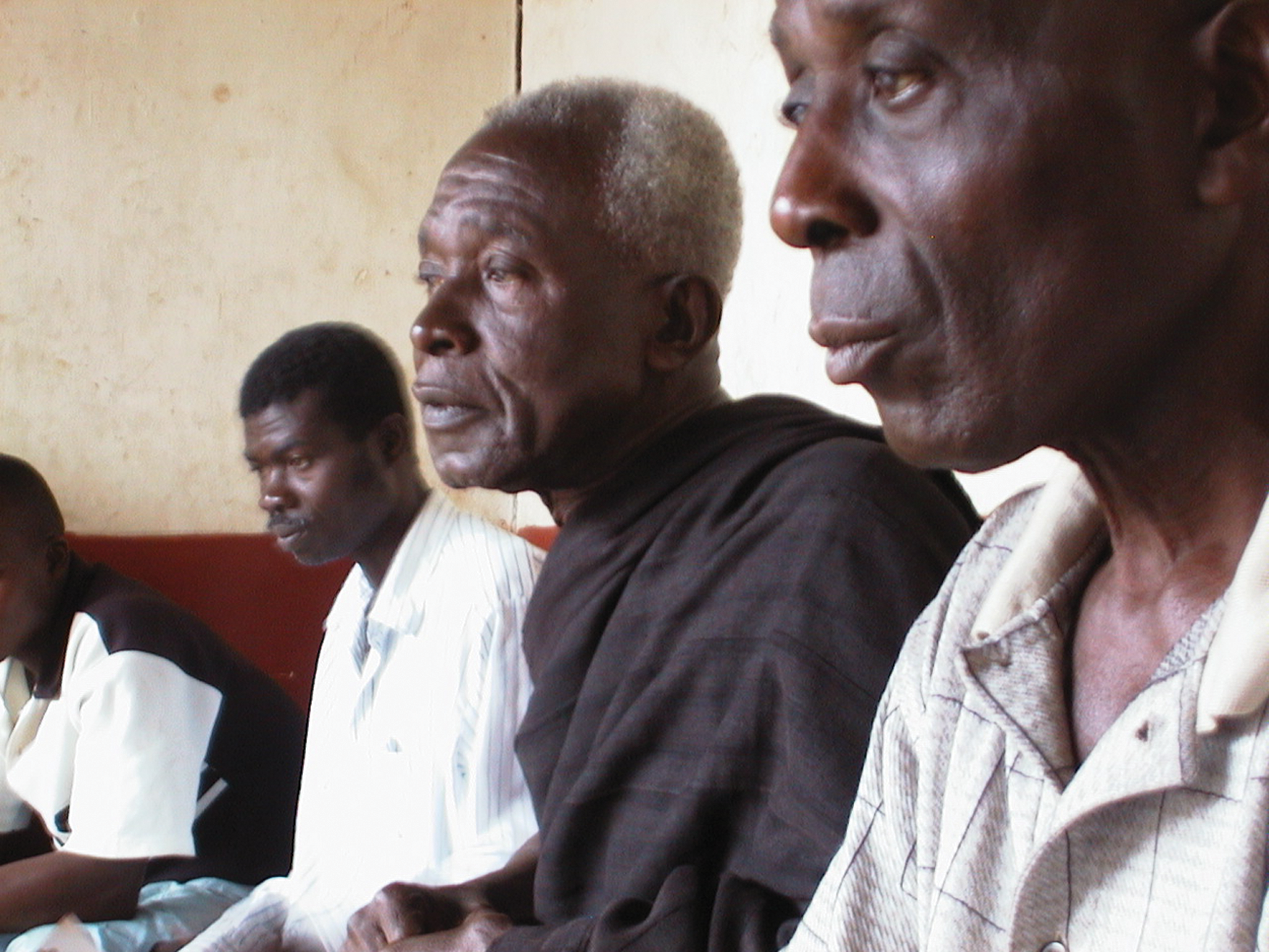
The late Chief, Nana Mpasatiahene (centre) and Nana Ketehene (right)
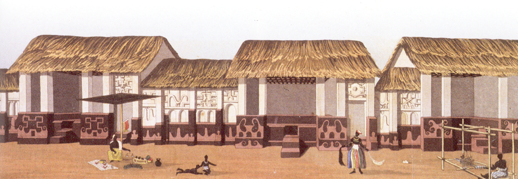
Houses in Kumasi, 1819. Ashanti kings prescribed houses built along straight lines, inspired by travellers’ accounts from Europe
There is considerable variation in how chiefs respect their traditional obligations as caretakers vis-à-vis the community. In a study of sub-divisions in former villages outside Accra, Gough suggested that while in some cases there had been blatant greed on the part of chiefs who personally pocketed the revenue from selling plots, other chiefs used the revenue for development in the wider interests of the community.(11)
In terms of land issues, Mpasatia is partly influenced by characteristics common to most traditional Ashanti villages or towns and partly by the proximity to Kumasi, which affects issues of transport, employment, housing and land prices. Officially, land in Mpasatia is “owned” by Nana Toasehene,(12) the Paramount Chief, but it is administered by the local Chief in Mpasatia with little outside interference. The Chief is sometimes referred to as the custodian of the land, sometimes as the owner. According to the Paramount Chief: “The amount of land somehow signifies the power and influence of the Chief. . .in Kumasi all the land has been sold and that diminishes one’s power to organize the people for communal activities.”(13)
The importance of land explains the strong feelings invested in the debate around who has the authority to interpret and narrate Mpasatia’s history. The origins of recent social and political conflicts date back to the 1990s, when the Nkwanta Scheme was implemented. This scheme involved the planned development of land to the south of Mpasatia to provide plots along more “modern” lines. During the debate around this scheme, the differences between the Chief, the clan leaders and the Paramount Chief were repeatedly stressed by the District Chief Executive;(14) however, he left no doubt that the Chief held authority over land under the Paramount Chief and ultimately the Asantehene, who has the ultimate authority over all lands in Ashanti. The local chiefs are expected to administer the lands under the supervision of the paramount chiefs. In our case, the differences were between the clan leaders and the Paramount Chief.
Authority over building regulations is weak in most non-urban areas of Ghana. There is a building code but it is hardly adhered to. When land is allocated to an individual by a chief, he is given an allocation note to be taken to the Land Title Registry so that title to the land can be registered. A plan for the structure that is to be built then has to be approved by the Town and Country Planning Department before any activity can take place on the land. In practice, developers do not wait for approval. This parallel system exists simply because most land belongs to individuals, families or clans, and there is no direct “interference” by the government in its allocation.
Iv. The study methodology
The research described in this paper involved an enquiry into the “democratization of planning” and identified a number of issues that were studied in depth, including governance/participation, communal labour and urban history. The case of the Nkwanta Scheme (which was to provide plots) included many of these issues.
The study was implemented through a series of qualitative and structured interviews, and also involved a search of archive material. The most important empirical data were obtained from in-depth interviews with the following: the late Chief, Nana Mpasatiahene; Nana Ketehene,(15) during the Chief’s long absence; the Toasehene; the Secretary of the Unit Committee; and the District Chief Executive (DCE) of what was Atwima district until 2004. This was backed up by a sample survey of 10 per cent of the households in Mpasatia and by in-depth interviews with 27 household heads.
Information about the Nkwanta Scheme specifically came from the Chief, the DCE, the Chairman of the Land Allocation Committee and record books held by the Chief. We are also indebted to a study carried out in 2001–2003 by two Danish students of architecture and geography, Lange and Rasmussen, who interviewed local leaders and surveyors about the Nkwanta Scheme.
It proved difficult to obtain formal records on spatial development. Most of the entries that were supposed to be listed in registry books in the archives in Accra and Kumasi were missing. The archives of the Asantehene in Kumasi had no information on Mpasatia. There were no traces of the plans of the 1925 layout in Mpasatia or of any later plans. Plots were added incrementally on the ground to the initial grid pattern layout. According to a 2003 account: “They were using a compass to know the bearings, a 100-foot measurement line to know the size and small cement bricks as demarcation pillars.”(16)
In addition to the dearth of formal records, other sources were not always easy to access. The Chief sometimes proclaimed that transparency was important to him; at other times he closed the books to the researchers. Appointments were rarely kept and most interviews with key informants were based on numerous visits, luck and patience.
History in Ashanti is in itself a sensitive issue, not merely a matter of interesting tales. The interpretation of the “truth” that is accepted by the majority (or endorsed by the high ranks of the chieftaincy hierarchy), about who owes allegiance to whom and which clans were historically given the right to use and take custody of the land is decisive in local power relations, not least for the control of, and right to allocate, land. In many traditional towns and villages there are conflicts between chiefs and the “truth” is often contested.
While in the absence of any records in the archives(17)the official version of Mpasatia’s history was provided by the Chief, in fact the Paramount Chief and Nana Ketehene recounted contesting versions. We were under pressure by some local leaders not to listen to anybody other than the Chief regarding Mpasatia’s history.
However, despite conflicting versions of some of the facts, all were agreed that Mpasatia first originated during the period of Osei Tutu, the first king to assemble the Ashante in around 1700. The settlement was founded in the eighteenth century not far from the Nkwanta Scheme area and moved to its present location in 1886 according to some informants. The narrative of how the original site of Mpasatia was identified 300 years ago was rich in detail, but accounts of even major events in the twentieth century were very spare.
V. Mpasatia – development prior to the nkwanta scheme
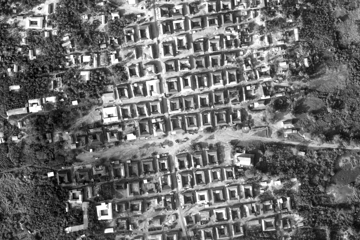
Rural Ashanti is exceptional from a spatial and planning point of view. Seen from the air, the country is scattered with small grid pattern-shaped settlements. The layout of square compound houses was characterized by British planners in the 1940s as “traditional” or “habitual”,(18) which was surprising for a forested area; however, the first foreign records from Kumasi confirm this.(19) The Ashanti kings were very interested in European urban planning and prescribed straight line development in Kumasi; the nobility were accommodated in classic compound houses. There is scarce data on the history of settlement (European archaeologists and donors are more focused on their own colonial past). We have no information to judge whether or not the nineteenth century grid patterns survived until the British burned down Kumasi in 1900. Judging by tales from Mpasatia, by the 1920s Ashanti settlements were unplanned and disorganized.
The British adopted the grid pattern as a template, accelerating redevelopment following a severe plague epidemic in Ashanti in 1924. Within a few years they had replaced virtually all non-permanent structures in Kumasi as well as most villages in Ashanti, including Mpasatia. Thus, a straight line, gridiron-shaped street pattern replaced Mpasatia’s unplanned “swish” (mud) hut settlement. No drawings have been found, but the Chief’s story of events was confirmed in an interview with a 100-year old lady who experienced the radical change that was positively received by residents as an improvement (modernization).
The original sub-division of 1924–1925 is believed to have been adequate in accommodating development right into the 1980s. There were around 40 plots in 1925, with compound houses measuring 60 x 60 feet, equal to the plot size; some were slightly bigger. By 2000, this dense housing area had grown to approximately 100 houses. Our surveys in 2003 showed an extra 90 plots in the eastern and western fringes of the central area, while post-1980 sub-divisions in “Cadbury” (named after the cocoa establishment in the area) and “Zongo” (also named “International”) outside this area had a further 320 plots, making a total of around 500 compounds. Indeed not a dramatic growth.
Decisions on the sub-division of land were taken by the Chief and his elders. As explained, the Paramount Chief, traditional owner of the land, was supposed to be consulted in all dealings concerning land. Planners in the then Atwima District Assembly had to approve any layout and, in principle, they could work out the plans for new land sub-divisions; however, this did not happen.
Chunks of land were converted incrementally from farming plots into urban plots. There was no formal plan for what land to develop next or where to locate future infrastructure. However, in Mpasatia, the Chief functioned as planner, and although a comprehensive plan was never drawn up, it existed in his mind. He had a clear idea of what to develop where, e.g. reserving the eastern part for institutional development, particularly schools, and limiting development to the west.(20)
Expansion meant that the town’s development was approaching its topographical limits within the boundaries of two major streams/valleys that converged towards the north. Development on the other side of the eastern stream had been encouraged for educational institutions, while the town shrine limited development to the west. It is still commonly accepted in Mpasatia that development should not go beyond the west of the shrine – indeed an effective type of land management.
Vi. Initiating and designing the nkwanta scheme (1993)
Until the late 1980s, town plots in Mpasatia had been “produced” ad hoc and in small numbers when the need arose, for example for housing or for schools. The Chief and his Land Allocation Committee decided where, how and to whom allocation was possible.
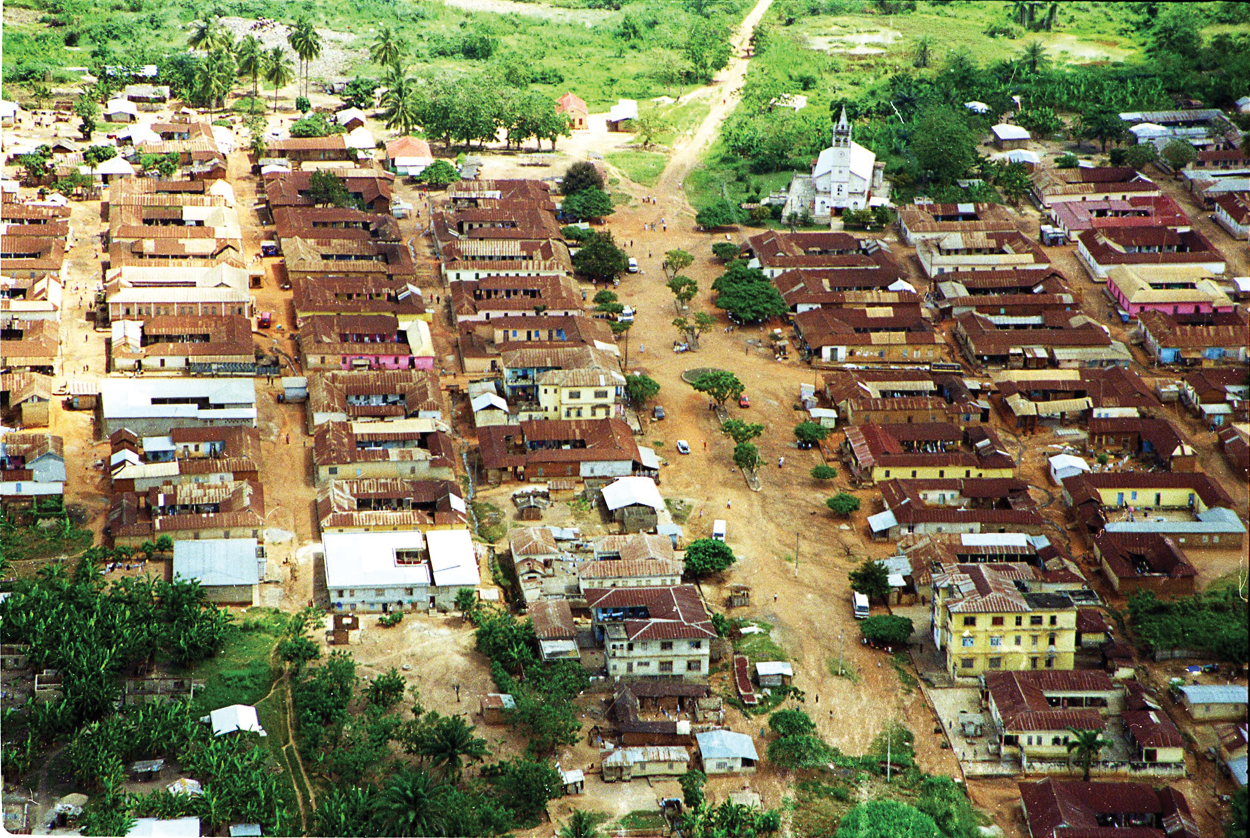
Aerial photo of Mpasatia
Compound houses in the central part of Mpasatia
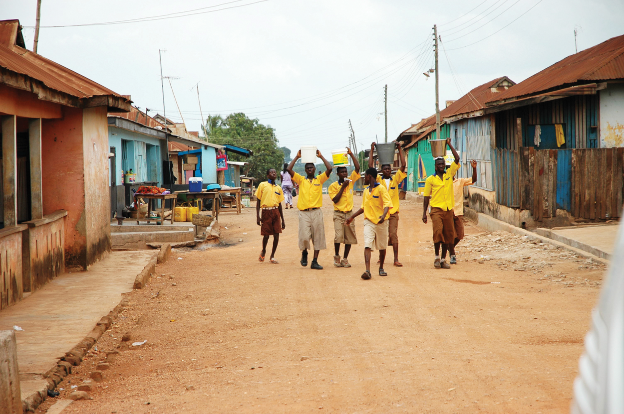
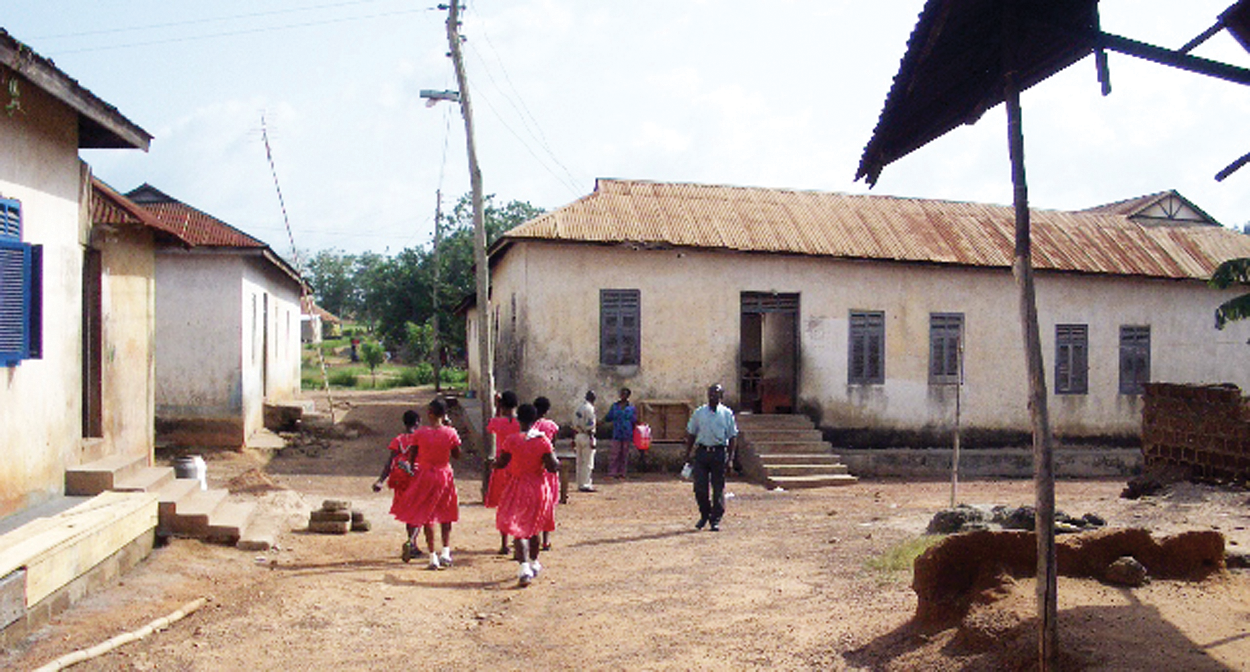
Typical street in Mpasatia
Reaching the limits of expansion within the boundaries mentioned above, in 1993 the Chief took the initiative to open up land south of Mpasatia for the development of big plots (100 x 100 feet) with wide streets, thus discontinuing the long tradition of plots measuring 60 x 60 feet being sub-divided by the local leaders themselves. The strategy was conceived by the Chief and one Mr Yeboah – then an assemblyman representing Mpasatia and later, until the end of 2004, DCE of the erstwhile Atwima district, and himself a native of Mpasatia. The Chief explained the motive, which was: “. . .to invite more developers and to expand the township. We wanted a fine town, a neat town. We have to do more than our ancestors did.”(21) His vision was clearly influenced by developments in Kumasi and further afield.
The change in Ghana from grid pattern layout with traditional compound houses to western-inspired middle-class neighbourhoods with accommodating big plots and detached houses, clean environments and beautiful shopping centres was fast and fundamental.(22) The ideals of the Nkwanta Scheme initiators are an example of this change in style. Although no formal design guidelines or building codes were established, the chairman of the Land Allocation Committee explained that the use of mud and bamboo or thatched roofs would not be allowed. Lange and Rasmussen quote the DCE:
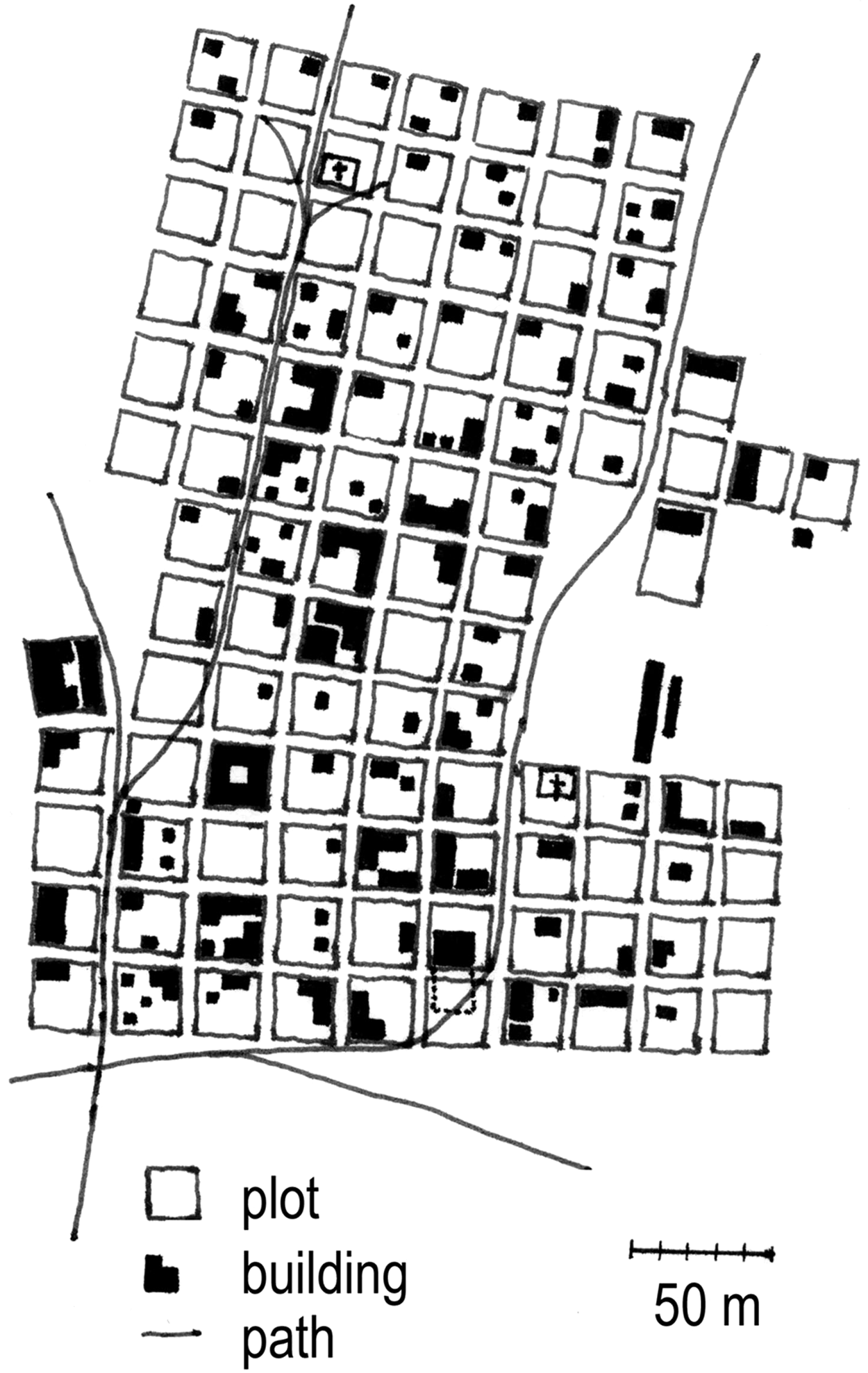
Zongo or “International”: the section to the northeast of the older part of town. Extensions and new plots implemented without drawn plans by the land allocation committee of Mpasatia by pacing, compass and rope prior to 1993
“We are going away from the old style. We have new technology and we have maybe done some imitations from you. The new scheme will make a safe neighbourhood with empty streets, because there are walls and gates and it is very easy to catch a thief running down these empty streets.” “As time goes by, people want more and more to be on their own” he explains. “The government planners agree on the individuality and explain that it is better to secure the houses and plots, than having them open as in the northeast area. Most find the form and the process of the new planning as progress.”(23)

Sign advertising typical services. Kumasi-style modern development was a vision for Mpasatia’s development after 1994
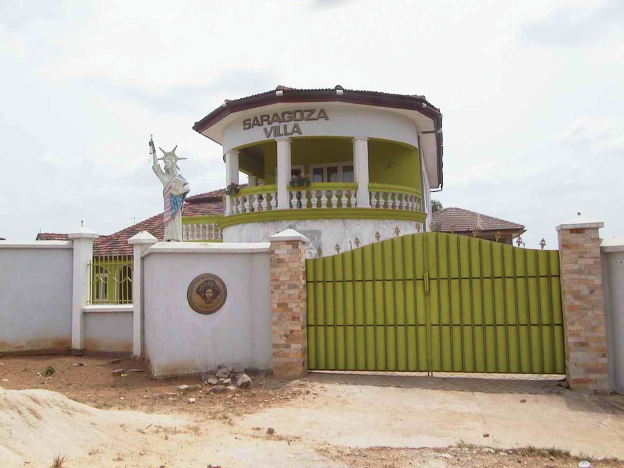
Villa on the outskirts of Kumasi, 2004
The design work had been assigned to surveyors. Lange and Rasmussen explain:
“The DCE […at that time the assemblyman] got permission from the Chief to find a private surveyor in Kumasi to make a scheme for a new area to the south. This location was chosen because of the road to Ivory Coast, which is seen to have great potential in relation to future commercial activities. According to the DCE it is normally the surveyors and planners from the DA [District Assembly] Planning Department who should prepare these plans, but in this case it was done without the DA planners. We were told that they normally would charge 3 million cedis (US$ 450 in 2001) to draw a plan like [the Nkwanta].”(24)
The process of designing the sub-division was not particularly inclusive. The Toasehene(25) (under whose authority the Chief administers the land) explained that he was not involved when the Chief in Mpasatia decided to sub-divide the Nkwanta Scheme: “I asked the Chief to bring the scheme to me and indicate the number of plots given out and he didn’t come.” The Toasehene claims that at the time he was not given a copy of the plan: “If there was cordiality between us he should have shown it to me first. Because the land belongs to the Awere [clan] ‘stool’ and he is the caretaker of the land, so I as the overlord should have been aware.”
The users of the land were not involved in the decisions. They were invited to a meeting in 1996 to be informed of the plans, but few seemed to be aware of them.(26) Farmers had to stop cultivation as soon as the demarcation started. However, “. . .they could continue farming until the new plot owners started building.”(27) Farmers who had to stop farming had to be compensated. Of five plots developed, they would retain one. We could only identify one case that followed this pattern.
Vii. Struggling for approval of the project
Approval was not just a matter of following technical protocol but was also victim to conflicting political power. As explained above, drawing up the plan had been particularly difficult. By 1994, 252 plots had been drawn up on paper,(28) and in spite of the fact that the plan had not yet been approved, by 1995 approximately 125 plots had been allocated. Building permits from the District Assembly cannot be issued in an area without an approved layout, and any violation of this can theoretically attract a fine. So while construction was therefore illegal, as mentioned earlier the Chief could, in principle, withdraw a plot from anybody failing to build.
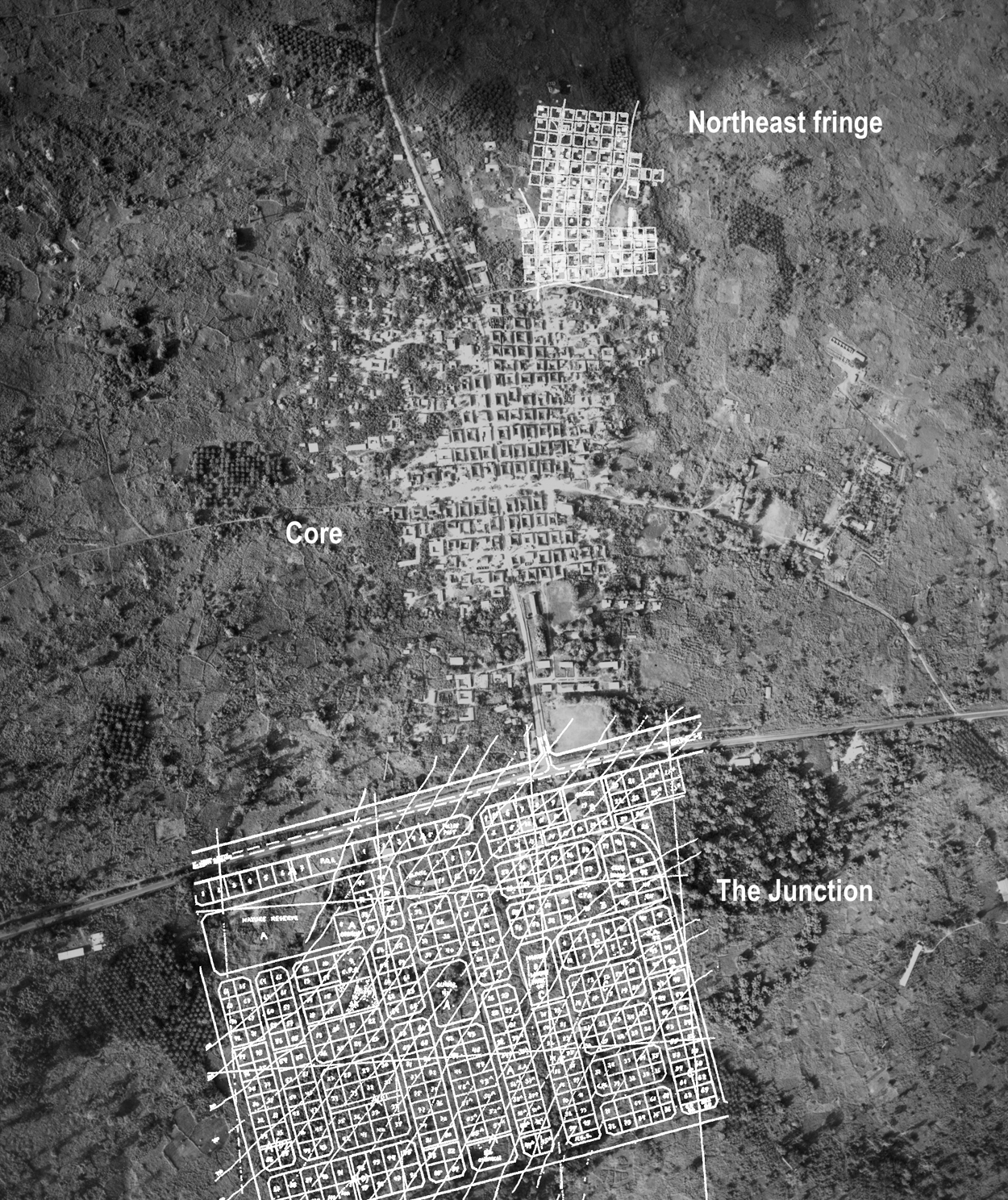
Location of the Nkwanta Scheme. This was named after the junction between the main east–west road and the access road to Mpasatia
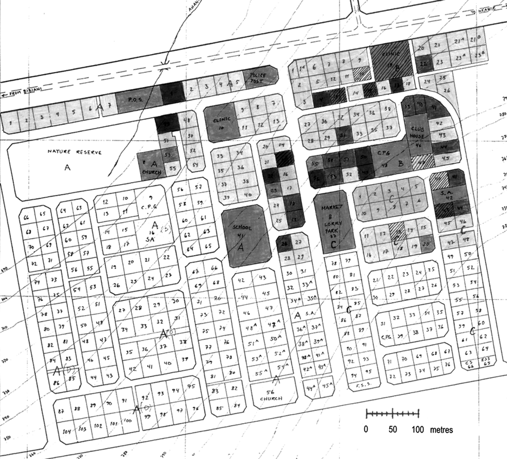
The plan for the Nkwanta Scheme in 1993, with the main road to the north. Plots sold before 2000 are shown as shaded
By 2001, the plans still remained with the District Assembly in Nkawie for approval. The planner had identified a number of imperfections in the first submission, errors that could be corrected by him and the surveyor, in return for plots as payment for the work, in order to approve the plan. The Toasehene explained the error: “It was about a road at the scheme that was not demarcated well. But I drew the attention and it was corrected.” This was confirmed by the DCE.(29)
The Chief trusted the planners in the District Assembly to respect the plots that had already been demarcated and sold. They finally accepted the plan and it was presented to the District Assembly for approval, but according to the planning office one (un-named) member opposed the approval for untold reasons. The Chief refused to comment on this in October 2004. The Toasehene, however, explained that he had discovered some errors, including a label on the drawing that read “Mpasatia stool lands”, suggesting that the land in question belonged to the Chief and not to the Awere “stool”. The use of “Awere” is important because only particular clans can ascend to the throne. By maintaining Awere, you entrench the history of the royal line. According to the former DCE,(30) by 2007 it had still not been possible to assemble the committee responsible for the approval.
Viii. Surveying the scheme – a nightmare for local leaders
Implementing the sub-division on the ground became a nightmare for local leaders in Mpasatia. The Chief explained that they had been cheated by surveyors several times, one in fact being fake surveyor. They charged for and were paid upfront for jobs that they did not complete.
The first surveyor delivered nothing. The second was paid, started measuring and drawing, “. . .but he left unceremoniously.”(31) The Chief’s council was unable to collect sufficient money to pay the third surveyor’s bill in full, although they paid him 1 million cedis (US$ 150 at 2001 rates) and gave him five plots. The surveyor considered that inadequate and demarcation was abandoned half way through, with 126 plots demarcated by 1996. According to the Chief, the fourth surveyor (employed in 1997) added some plots to the drawing but kept it to himself. He only used it when he came to Mpasatia, when requested by the Chief, to demarcate any added plot (charging 40,000 cedis per sub-divided plot for the work plus transport and other costs). Interestingly, the Ashanti region appears to have a history of problems with surveyors. According to archive letters from the Provincial Surveyor in 1930, a majority of sub-divisions were carried out by “. . .unauthorized surveyors and forwarded by unscrupulous clerks.”(32)
The plans, therefore, were not fully completed until 2001, by the fifth surveyor. However, of 252 plots now shown on the drawing, 125 had already been allocated by 1995. The least attractive 93 plots had still not been allocated by October 2003.(33)
By 2001 there were 20–25 houses on 150 allocated plots in the Nkwanta area,(34) a few of them in existence prior to the sub-division. A visit to the area in 2007 and a windscreen survey in 2010 suggested that very few houses had been built since 2001. Had people acquired the plots because of an immediate demand to build a house, or had they acquired plots for eventual future use, or perhaps for short-term speculative reasons? The latter seems unlikely; the Chief knew of only two cases of allottees selling their plots.
The idea of middle-class villas and shopping centres remained a dream. According to unwritten building regulations, the use of mud and bamboo and thatched roofs is not allowed. According to the late Chairman of the Land Allocation Committee (LAC) this is because the houses have to be “modern” and these simple materials could harm the town’s image. At the same time, not much weight is attached to these regulations: “Though people in the new areas to the northeast are building bamboo houses, it is not all that serious”, the LAC Chairman admitted.(35) Unauthorized construction emerges in the Nkwanta Scheme as elsewhere in urban Ghana. However, the council claims to keep development under surveillance. Houses are mostly of the conventional, very modest type seen elsewhere in the “old” Mpasatia.
Ix. Plot prices increase
The practice of low-cost plots meant that up to the 1980s any family who wanted to build a house could afford and in theory be allocated a plot in Mpasatia. According to the Chief, until 1991 a plot could be obtained for three bottles of schnapps (one of which was passed on to the Paramount Chief). The Chief explained that in the 1980s “. . .my interest was in the expansion of the town. So most of the plots in the International (Zongo) area and some other places were given for free.”(36)
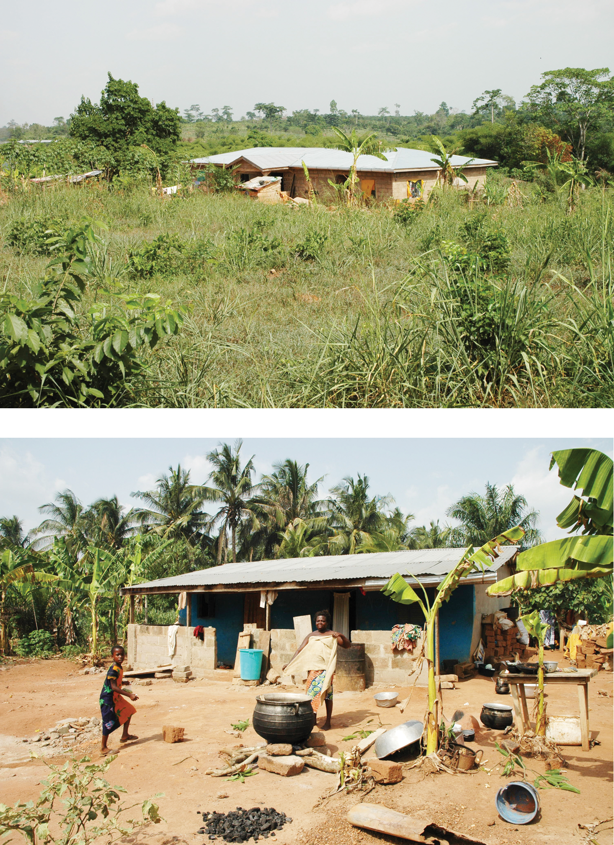
Most houses built in the Nkwanta Scheme are of poor quality
From 1991, before the Nkwanta Scheme was launched, a symbolic payment or “ground drink” of 40,000 cedis (US$ 100), rising to 60,000 cedis, was demanded.(37) This was not conceived as payment for the land itself; native Mpasatians did not have to pay for the plot itself, as in principle the land belongs to them as customary, collective property, not to be sold. The Chief explained:
“Even some part of the Nkwanta area, before the scheme was prepared, was given for free. Some members of families that have the right to farm on those lands started developing because it is their ‘family land’ and they are also natives of the town. So I did not stop them. All that we wanted to see was to see the town developed, so we did not charge them anything.”(38)
With the advent of the Nkwanta Scheme in 1995, the notion of free land was challenged. In the beginning, prices escalated in order to recover the actual costs of the surveyors and planners; the administrative costs had been calculated at 150,000 cedis(39). Hence, from an initial charge of 50,000 cedis (US$ 100) plus some topping-up, plots were soon being sold for 200,000 cedis (US$ 150) – with a reduced price of 150,000 cedis for Mpasatians – and increased to 500,000 cedis by 1998 (US$ 200).
From 2000, some plots were targeted at those who could pay or who had a strong lineage relation with Mpasatia. Who would be considered and who not? Would there be a preference for affluent “outsiders” or would there still be special consideration for Mpasatians, to whom the land belongs according to the traditional view? According to the Chief and the Land Allocation Committee chairman, this question was not an issue because there were more plots available than interested builders. By 2001, “outsiders” were being charged 1.5 million cedis (now around US$ 225), and in 2003 Mpasatians could get a plot for, perhaps, less than 1 million cedis. Steadily, however, prices followed the market and by 2004 had reached 2 million cedis (US$ 250 at current exchange rates) for outsiders, even though many plots remained unsold.(40) The argument for the higher prices for non-Mpasatians was that:
“. . . the strangers do not attend communal labour or pay taxes. For strangers the price is fixed, but when local people want to buy plots, the Chief and the LAC will discuss the price in each case, depending on what the buyer is doing for the community.”(41)
X. Suspicion about revenue and its distribution
Since the early colonial times, land revenue – whether as “ground drink” or plot payment – has remained an important source of income for the chiefs, hence also for the Mpasatia Chief.(42) Use of the revenue is subject to scrutiny in order to detect any improper appropriation, not least due to a tradition of closed decision-making with no obligation of accountability. In Ashanti, political conflicts often originate in struggles over the control of land allocation and the associated revenue.(43)
There are diverse answers to the questions of how land is redistributed and where the revenue goes. For example, in an interview in 2004, the DCE explained that in the absence of explicit rules for sharing the revenue, around 1998 the Asantehene established a formula for redistribution based on
Finally, however, the Chief explained that the
We tried to trace the flow of money paid for plots. The accounts book for the Nkwanta Scheme where payments were recorded (noted as “ground drink”) confirmed a price of 1.5 million cedis per plot (US$ 225) by 2001. We suspect that the buyers were non-Mpasatians but could not verify this before the interview was terminated. However, by 2004 the accounts book only had entries for 15 plots sold (all between 1997 and 2001), whereas the book of records listed 159 plot owners (with names) by 2003. The Chief could not explain this, but insisted that all payments had been carefully entered. It is likely that accounting did not start until 1997, when the Chief started the accounts book; he personally did all the recording.(45) We have no explanation as to why so few plots were recorded. It is possible that many plots were sold or allocated prior to 1997 (when the accounts book was started) but that records of the payments were never made. Other plots were perhaps not sold but given as compensation to those who farmed the land. It is also possible that some plots were given to recipients outside Mpasatia, e.g. to surveyors and planners in lieu of payment.
The Paramount Chief openly criticized the Chief in the Council of Chiefs at Toase for non-transparent handling of land and land revenue.(46) The Chief was (partly because of this) suspected by some citizens of misusing revenue from land sales. He did, however, not disclose the accounts concerning the issue.
The DCE monitored the development over many years, including during his 12 years as an assemblyman, prior to taking up the position of DCE. He was convinced that the Chief had a full account of his income and expenditure and that his spending might have been even higher than his income.(47)
On the issue of transparency, the late Chief explained that:
“I have prepared all these records in the name of transparency. I know a time will come when I will not be here. Then people can read to know what was going on when I was there. If I have made it then you can see it. I am telling everybody that this is what has been happening during my reign and I was doing it for the town.”(48)
After many weeks of requests, we were promised access to the accounts book. When we met as agreed at the Chief’s palace on the morning of 27 October 2004, the financial secretary in charge of the book had unfortunately left for Kumasi. We offered and were reluctantly allowed to wait for him at the palace. He returned after dark. The Chief asked him to bring the book and we started browsing through it. However, after five minutes the Chief changed his mind. Probably troubled by our interest in the details, and provoked by the camera, the book was withdrawn with the remark that he was under no obligation to show it to strangers.
The Chief’s accounts book where payments were recorded – noted as “ground drink” – had 15 entries, the first dated 7 April 1997. The last entry but four (23 April 2001) is quoted here:
Ground drink:1,500,000 Administrative costs: 150,000 Balance:1,350,000 1/3 for Toase (Paramount Chief) 450,000 2/3 balance for Mpasatia 900,000 (Divided into four parts:(49) for each): 225,000
As shown, there is no share for the Asantehene, who is not supposed to receive his share from the revenue of plot sales but, rather, by being given a number of plots. According to the DCE, there is no systematic check by the Asantehene of whether a share of revenue is paid when a sub-division is approved and plots are sold (this perhaps explains the strong interest of the Asantehene in proper land registration). However, when a sub-division case is brought before him as the result of a conflict a check will take place, and in certain cases this has contributed to some chiefs being “de-stooled” for not passing on the appropriate share of revenue to the Asantehene.(50)
Xi. Any funds for the community?
A critical point relates to the share of revenue that benefits the community. As evidenced from the accounts records quoted above, the “community” receives one-quarter of what is left after the administrative costs and the Paramount Chief’s share are paid. This is supposed to be administered by the Unit Committee.
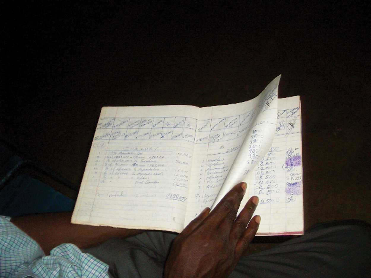
The accounts book for plot sales
The Chief did not pay the community its share although, according to the DCE, he could have handed over their share of revenue for the land to the Unit Committee. However, during the 1990s there had been a long conflict between the Chief and the former chairman of the Unit Committee (Nana Ketehene) and there were allegations of misuse of funds. Hence, the Chief decided to disburse funds only for concrete projects.(51)
The secretary of the Unit Committee was unable to assess the revenue from plot sales, and even the percentage he could use for public works was unknown to him:
“What is happening is, even though we do have a Land Allocation Committee in place, we’ve not yet completed the modalities for distributing funds. What was in place previously was that when land was sold before the formation of this committee, the Chief had a certain percentage that he gave back to the town, and it is out of this that for example he paid 300,000 cedis to assist on the micro project.”(52)
Xii. Social differences and spatial polarization
What was the impact of the Nkwanta Scheme on the socio-spatial structure? Local leaders and common Mpasatians live together in the small town area, both owners and tenants, and all quarters of the town are characterized by a high social mix. Partly due to this, the local leaders have a very good sense of the residents’ problems and priorities, even if democracy and participation are not highly developed in Mpasatia. One might have feared that the Nkwanta Scheme would lead to a geographical polarization, slowly siphoning off the better-off (and the leaders) and segregating the poorest in the old part of town, which could have had negative consequences for the democratic process. However, the failure for the time being to build a middle-class area in Nkwanta has made such fears unfounded.
Why did so few build in the Nkwanta Scheme? Our interviews suggested that 20 per cent of the population (350 households) could afford to acquire a plot in Nkwanta and to build, although some appear to have been excluded because the Land Allocation Committee did not consider them to be eligible. Nevertheless, only 157 persons acquired plots, and a brief check in July 2010 confirmed that up to now, only a few wanted to live there. The houses that have been built remain far from the dream of nice villas with flower gardens behind walls and elaborate gates. What we see instead are small urban farming sites with modest houses. Some Mpasatians say that the plots are too far from central Mpasatia; to non-Mpasatians it is too far from Kumasi. Despite the existence of a number of households with sufficient resources, there is little or no upper or middle class in Mpasatia, in the sense of a group with aspirations for a different kind of life.
Although Mpasatia experiences net out-migration, there is a need for expansion to accommodate newly established families. There was no explanation of how the leaders intended to settle new family members who did not have the means to obtain allocations or to build in the Nkwanta Scheme; neither did the leaders have any suggestions for the future settlement of people with modest or very modest incomes.
New households had previously been accommodated in the traditional sub-divisions, and it is therefore not surprising that there is a continued high level of building activity, leading to densification in the old areas of town. People remain in the old stock of compound houses, but limited income, complex ownership structures and a change in family patterns towards nuclear families has reduced the motivation to maintain the old stock. Hence, we may foresee a steady deterioration of the central areas.(53)
Xiii. The inappropriateness of sub-dividing large plots
The late Chief had good intentions for the town to grow when he took office in 1981: “When I became the Chief I made it a policy to make people make more houses. If I were to stay in office for 10 years, at the end of the period there should be double the amount of houses.” As he explained: “We wanted a fine town, a neat town. We have to do more than our ancestors did.” This remained a dream.
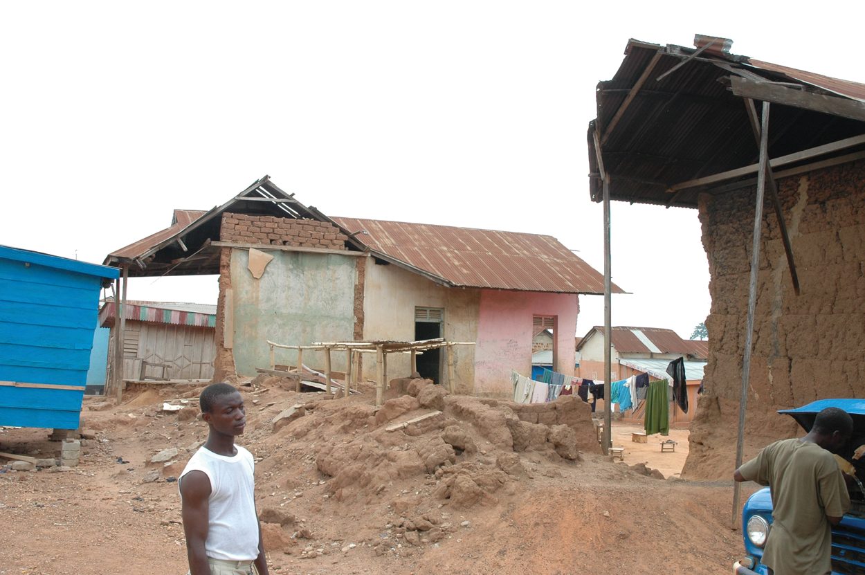
Partly collapsed house in central Mpasatia – removed by 2010
There are few winners in the case of the Nkwanta Scheme. The Chief and the council claimed to have spent a lot of money on plot sub-division, not least on surveyors who took money and parcels of land from the Chief but failed to deliver the expected outputs. However, the actual balance of expenses and proceeds from plot sales for the scheme cannot be verified. We have evidence regarding the sale of 15 plots, the rest remains written with ink on water.
Very few in Mpasatia have taken the opportunity to acquire one of the big plots in the Nkwanta Scheme, and there are only a couple of houses that have been built to the standard that was hoped for when the scheme was launched. Although there may be a demand for plots as a capital investment, any further sub-division of large plots for ownership rather than use would increase the amount of under-utilized land, with very expensive infrastructure for few if any houses. This would, at the same time, deprive Mpasatia of cultivated land.
The development of big plots for villas appears to be inappropriate in meeting the needs of the majority of households in small traditional towns, and even in Kumasi. The simple and classic layouts for compound houses implemented until 1990 by the Land Allocation Committee in the north of the town have been wholly appropriate for many. The low cost of land (“ground drink”) and the relaxed expectations regarding construction standards allow a majority of the population to start in a modest way, with chances of incremental improvement over the years.
The most important endeavour should be to sub-divide new land for smaller or mixed-size plots for common Mpasatians, with conditions for building that are appropriate to people’s resources – a stereotypical recommendation, but one that still holds.
Footnotes
1.
Our 10 per cent sample survey in August 2003 suggested that there were 7,750 inhabitants in Mpasatia, corresponding to 1,730 households.
2.
Regarding access to or ownership of a refrigerator, television, video, sofa set, freezer and electricity, the lowest score was found in the old central area, where most native Mpasatians live, and the highest was in the old palace and zongo areas, where most migrants from the north live.
3.
In this research, the Mpasatiahene is referred to as the “Chief”. Nana Owusu Piebere II, the late Chief, died in June 2005 and was replaced by Elvis Okyere, whose chieftain name is Nana Okyere Karikari II.
4.
The chieftain name is Nana Asiamah Afrifa Poku Ababio.
5.
“Nana” is the title used for chiefs. Five clan leaders are Otumfuo Abrimpong, serving at the court of the Asantehene and hence formally ranking very highly, but without authority over land. They include Nana Ketehene (Nana Kojo Adjei Boahene II, responsible for drums at the Asantehene court).
6.
Atwima district was divided into two in 2004.
7.
Konadu-Agyemang, Kwadwo O (1991), “Reflections on the absence of squatter settlements in West African cities: the case of Kumasi, Ghana”, Urban Studies Vol 28, No 1, page 149.
8.
Harvey, W B (1966), Law and Social Change in Ghana, Princeton University Press, New Jersey, 453 pages. One exception was Kumasi town lands, which after annexation of Ashanti in 1901 were treated as vested in the (British) Crown. In 1943, these lands were re-vested with the Asantehene.
9.
10.
See reference 8.
11.
Gough, Katherine (1999), “The changing nature of urban governance in peri-urban Accra, Ghana”, Third World Planning Review Vol 21, No 4, pages 235–247.
12.
Nana Asiamah Afrifa Poku Ababio.
13.
Taosehene, interview October 2004.
14.
The District Chief Executive of Atwima district until 2004, at which time the district was divided into two.
15.
Nana Kojo Adjei Boahene II.
16.
Lange, U and M F Rasmussen (2003), “Planning the future of Mpasatia – land sub-division and local planning”, in J Andreasen, J Eskemose Andersen and A L Schmidt (editors), Mpasatia – a Town in Ghana, Tales of Architecture and Planning, School of Architecture Publishers, Copenhagen, page 227.
17.
National archives in Kumasi and archives of the palace of the Asantehene.
18.
Fry and Drew, the first town planners in Kumasi refer to “. . .habitual Kumasi compound type laid out in a grid iron plan.” See Fry, E M and J B Drew (1945), “Draft town planning scheme for Kumasi”, Office for the Town Planning Advisor (to the Resident Minister), West Africa, August, page 4.
19.
Bowditch, T E (1819), Mission from Cape Coast Castle to Ashantee, Frank Cass & Co, London, 512 pages.
20.
Mpasatiahene, interview July 2003.
21.
Mpasatiahene, interview October 2003.
22.
See Andersen, J E, J Andreasen and G Tipple (2006), “The demise of compound houses – consequences for the low-income population in Kumasi, Ghana”, RICS Research Paper Series Vol 6, No 8, March, pages 1–43.
23.
See reference 16, page 232.
24.
See reference 16, page 228.
25.
Toasehene, interview October 2004.
26.
27.
See reference 16, page 228.
28.
The source for this is the book of records and the chairman of the Land Allocation Committee.
29.
See reference 16.
30.
District Chief Executive, interview March 2007.
31.
Mpasatiahene, interview October 2003.
32.
Provincial Surveyor to Chief Commissioner, Ashanti, 12 November 1930 (Kumasi National Archive arg. 1/1/125)
33.
According to the books of records at the Chief’s palace shown to us in February 2003, the Nkwanta Scheme included 252 plots divided into four blocks: Block A with 69 plots; Block B with 56; Block C with 95; and Block D with 32 plots. Only four plots remained unallocated in each of blocks A and B, and in blocks C and D the majority of plots (85 in total) were unallocated.
34.
See reference 16.
35.
See reference 16, page 230.
36.
Mpasatiahene, interview October 2004.
37.
Mpasatiahene, interview October 2003.
38.
Mpasatiahene, interview October 2004.
39.
According to the accounts book, this was the total administrative cost by 2001.
40.
District Chief Executive, interview May 2004.
41.
Interview with Land Allocation Committee chairman in 2001. See reference 16, page 230.
42.
Mpasatiahene, interview October 2003.
43.
See Sollien, S (2003), How to Sell Land when the Chief is Dead and Everyone is a Chief, Research Report, Royal Danish Academy of Fine Arts, Copenhagen, 71 pages. Also published in Norwegian as Sollien, S (2005), “Hvordan selge jord som ikke kan eies I Kumasi, Ghana”, Kart og Plan No 3, pages 137–145.
44.
According to: first, the District Chief Executive (August 2003); second, the practice in Mpasatia as shown in the Chief’s accounts book (Photo 10); and third, the Land Office of the Asantehene, according to Sollien, see reference 43.
45.
According to Edusei, financial secretary for the Unit Committee, March 2007.
46.
District Chief Executive, interview May 2004.
47.
District Chief Executive, interview October 2004.
48.
Mpasatiahene, interview October, 2004.
49.
One each for the Chief, the elders, the “stool” and the community.
50.
District Chief Executive, interview October 2004.
51.
See reference 50.
52.
Secretary of Union Committee in Interview with Unit Committee, August 2003.
53.
For more on deterioration in Mpasatia, see Ryslinge, A (2003), “Falling apart, will and ability for maintenance”, in J Andreasen, J Eskemose Andersen and A L Schmidt (editors), Mpasatia – a Town in Ghana, Tales of Architecture and Planning, School of Architecture Publishers, Copenhagen, pages 147–167.