
Abstract
Although growth management programs have many purposes, a critical one is to contain urban and suburban sprawl. Their efficacy in this regard is not well understood. In this paper, we review a comprehensive set of growth management tools, used by urban planners and policymakers to curb sprawl, starting with the history of the tool, then describing how it works in practice, and finally presenting any available empirical evidence on how well it works to curb sprawl and/or achieve other public purposes. While growth management isn't a panacea for controlling sprawl, it is certainly not the failure implied by critics.
Introduction
The original purpose of growth management was farmland preservation but a shift has occurred in recent years to growth management as a tool to promote compact development over sprawl (Park et al. 2020). Today, it is common for contemporary planners to believe in the following causal chain: growth management tools - - -> compact development –––> good outcomes
The second link in the causal chain is shown with a solid arrow. Planners may quibble about the precise benefits of compact development, but the empirical evidence in favor of compact development is overwhelming (Ewing and Hamidi 2015).
What is less compelling is evidence of growth management effectiveness. In a recent study, Landis (2021) published a comprehensive overview of some of the local growth management programs in the U.S. The study described the evolution of these programs and the literature on the effectiveness of these programs in practice. Further, it tested the effectiveness of some of the growth management tools by comparing a region implementing a program with one that has not, based on population growth, sprawl, and fiscal and housing price outcome measures. Results were mixed.
Some publications place growth management and smart growth in historical perspective (Chapin 2012; Weitz 1999, 2012). Others, including Growth Management in Florida: Planning for Paradise (Chapin, Connerly, and Higgins 2007) and Growth Management and Public Land Acquisition (Chapin and Coutts 2011), put together extensive reviews of growth management programs in one or more U.S. states (e.g., Florida, Maryland). There exists only one comprehensive assessment of smart growth programs, and this is not organized by tool but rather by state (Ingram et al. 2009). It does not address the specific issue of whether tools induce or discourage sprawl, the main topic of this paper. It is also dated at this point.
Our graduate planning students have been working for the past several years on a comprehensive literature review of growth management effectiveness, particularly in controlling sprawl. It is a big job. There are many measures/tools and many studies of each. This review covers the major growth management tools used since the early 1970s and offers a detailed overview of each tool and empirical evidence on each tool's effectiveness. Our tentative conclusion: Effectiveness depends on the particular place, the particular measure, and how it is designed and implemented. In other words, “It all depends.”
Perhaps it most depends on how growth management tools are packaged together, as is often the case. Growth management tools individually or in packages aren't a panacea for controlling sprawl, but as we will show in this paper, they are certainly not the failure implied by some critics.
Growth Management Generally
This review uses the term growth management to encompass both growth management in its original form and what has more recently been called smart growth. The former began in the 1970s, emphasizing traditional anti-sprawl growth management policies. The latter began in the 1990s, concentrating growth in walkable urban centers. The tools of growth management and smart growth overlap, as do the purposes. Both strive for compact development over urban sprawl. One can think of smart growth as the end, and growth management as the means. This is not to say they are the same but rather to say the tools covered in this review encompass both.
Perhaps the feature that most distinguishes “smart growth,” as initiated in Maryland, from its growth management predecessors is its reliance on spatially specific incentives instead of land use regulations. “Local governments can grow anywhere they want but State funds for accommodating development are available only within priority funding areas (PFAs). Property owners need not clean up and redevelop their properties but grants are available for doing so…. Such reliance on incentives is what enabled these programs to pass the Maryland legislature and what makes them so attractive to other states” (Knaap 2017).
In addition, one can think of compact development and sprawl as lying on a continuum, with compact development having higher densities, more diverse land uses, more interconnected streets, more accessible destinations, and less distant transit (the 5 Ds – Ewing and Cervero 2010; Ewing and Hamidi 2017).
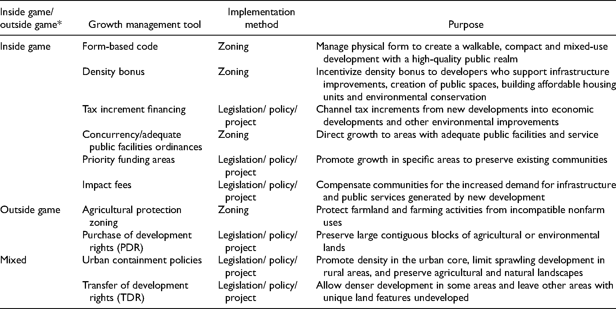
Growth management programs vary widely (see Table 1). Growth management to curb sprawl has two components: a) The Inside Game - where development is desired and promoted; and b) The Outside Game - where development is generally discouraged and allowed only at low density (inside/outside terminology is borrowed from Rusk 2010). Some tools do not neatly fall into one category or the other. These, we refer to as mixed. While controlling sprawl has long been identified as the “principal spatial objective” of growth management measures, the efficacy of regulations in realizing such an objective remains largely debatable (Landis 2000). Caruthers (2002) expresses this ambiguity by noting “Despite their considerable promise for reducing sprawl, growth management programs remain controversial because there is little rigorous empirical evidence of their effectiveness” (Carruthers 2002). To the contrary, land-use controls have sometimes been found to encourage, and even incentivize, urban sprawl (Cowan 2006; Landis 1992; Pendall 1999).
Growth Management Tools Reviewed in This Study.
Though studies of sprawl have yielded a diverse volume of definitions and interpretations of the term, an established and widely cited report by Ewing et al. identifies urban sprawl as embodying four predominant features: a population that is widely dispersed in low-density development, a rigid separation of land uses, a lack of well-defined activity centers (including regional, town and neighborhood centers), and a road network typified by large blocks and poor connectivity (Ewing, Pendall and Chen 2003a; Ewing, Schieber and Zegeer 2003b). The effects of this type of development pattern have been extensively studied in the planning literature and include more traffic fatalities (Ewing and Hamidi 2015; Ewing, Schieber and Zegeer 2003), poorer health outcomes (Berrigan et al. 2014; Ewing et al. 2014b; Fan and Song 2009; Hamidi and Ewing 2020; Plantinga and Bernell 2007), more air pollution (Schweitzer and Zhou 2010; Stone 2008), more extreme heat events (Stone, Hess, and Frumkin 2010), higher residential energy use (Ewing and Rong 2008), lower social capital (Nguyen 2010), longer emergency response times (Trowbridge, Gurka, and O’Connor 2009), increased teenage driving (Trowbridge and McDonald 2008), greater private-vehicle commute distances and times (Ewing, Pendall, and Chen 2003a; Ewing, Schieber, and Zegeer 2003b; Ewing et al. 2014a; Hamidi et al. 2015; Hamidi and Ewing 2015 ; Ewing et al. 2014b; Ewing et al. 2016a; Ewing, Hamidi and Grace 2016b), higher housing plus transportation costs (Hamidi and Ewing 2015), lower upward economic and social mobility (Ewing, Hamidi et al. 2016a, 2016b); emergence of food deserts (Hamidi 2020); shorter life expectancy (Hamidi et al. 2018), higher mortality rates from the COVID-19 pandemic (Hamidi Sabouri, and Ewing 2020; Hamidi, Ewing, and Sabouri 2020), higher adherence to social distancing during the COVID-19 pandemic (Hamidi and Zandiatashbar 2021) and lower innovation and economic productivity (Hamidi and Zandiatashbar 2019; Hamidi, Zandiatashbar, and Bonakdar 2019).
In response, growth management efforts in recent years have focused on challenging these trends, particularly emphasizing development that is compact and pedestrian-friendly and embraces medium-to-high densities, mixed-use centers, and high levels of street connectivity.
Which growth management measures, if any, effectively contain sprawl patterns of development and trigger the building of compact, mixed-use centers? Many states with the most comprehensive of growth management regulatory structures lack basic performance measures to gauge efficacy (Landis 2021). Further, as programs and priorities for smart growth differ from state to state, successful policies also vary widely. While states with well-established growth management programs were successful in some of their priority policies, they also performed poorly in other policy areas (Ingram et al. 2009). Though cities and towns have instituted a great number of regulations and incentives in hopes of curtailing sprawl, lack of systematic empirical evaluations of growth management policies has handicapped efforts to accurately measure overall effectiveness (Bengston, Fletcher, and Nelson 2004).
What is clear is that in many regions, sprawl development continues largely unabated (Landis 2017; Linkous 2017). Preference for strong local government autonomy and the enduring popularity of low-density zoning appears to effectively handicap smart growth efforts in many regions, even in those that advocate anti-sprawl efforts (Richardson 2003).
This paper strives to shed light on current knowledge of growth management effectiveness. We present nine sections that discuss single growth management tools or multiple closely-related tools. We start by outlining the tools’ history, then proceed to explain how the tools work. We conclude by providing empirical evidence, if it exists, on how these growth management strategies either contain or do not contain sprawl.
Zoning – Inside Game
In 1926, the concept of land use regulation was so novel that the New York Times encased the term zoning in quotation marks in a news account describing the emerging regulatory trend (New York Times 1926). Nine decades later, zoning remains the hallmark of land use regulatory frameworks in American cities and towns. And yet as concerns have shifted from the “evils of overcrowding” (Euclid v. Ambler 1926 [Revell 1999]) to problems associated with sprawl patterns of development, local and state governments have instituted, nearly as expeditiously as zoning gained a foothold in the nation, various zoning reforms.
Zoning for large lots can limit the supply of new housing in the jurisdictions that impose them. Demand for housing that goes unmet because of the control will probably be met in another location, but empirical studies provide mixed evidence on whether development will occur as infill in existing urbanized areas or as sprawl in newly developed areas (Pendall 1999). Conventional zoning (also referred to as Euclidean zoning) stands on the principle of homogeneity, separation, and exclusion that makes it what some consider ‘sprawl-inducing zoning.’ Conventional zoning often limits the accessibility of people in need of public amenities by placing housing far from nonresidential uses. The restrictions on maximum units per acre, minimum lot size per unit, minimum street frontage per unit, front yard setbacks and enormous parking lots called for by conventional zoning negate the possibility of compact development (Barry 2008; Hall 2007; Talen 2013). To combat these challenges caused by conventional zoning, several zoning reforms have emerged. Form-based codes, density bonuses, upzoning, and cluster zoning are some of the growth management strategies that have the potential to counter sprawl (Talen 2013).
Form-Based Code
History
Modern initiatives for embracing physical form as the core principle of land development regulation first began in 1980s when it started to become evident that urban sprawl was a result of conventional Euclidean zoning. Form-based codes emerged as one of the promising alternatives to mitigate sprawl (Parolek, Parolek, and Crawford 2008; Talen 2009; Talen 2013).
Among large American cities, Miami was the first to adopt a form-based code (FBC) followed by Denver (Parolek, Parolek and Crawford 2008). Borys and Talen (2017) have identified more than 600 codes in the US that meet the Form-Based Codes Institute (FBCI) criteria mostly clustered in the Southern California region.
How It works
A form-based code is a land use regulation that places greater emphasis on physical design than land use as the organizing principle of a city's urban form. The code regulates the elements of the built environment in relation to each other. The intended outcome is a walkable, dense, compact and mixed-use development (Cole 2008). The relations between building facades, public spaces, scale and types of streets and blocks, the form and mass of buildings are addressed in the standards of the code. Narrow streets, shorter blocks, and the elimination of on-site parking requirements are some common features of FBCs that contribute to an improved built environment (Parolek, Parolek, and Crawford 2008). By allowing different uses on the same block or lot and facilitating compactness, the urban form achieved by implementing FBCs can produce urban areas that are reminiscent of early American cities built before the dominance of the automobile. The inclusion of stakeholder input to FBC creation has been related to more predictable, consistent urban forms (Barry 2008).
Cities can adopt FBCs in mandatory or voluntary forms. A mandatary form involves replacing the existing zoning ordinance with the FBC. A voluntary form does not replace the current zoning regulation of the city, rather, it is an additional zoning regulation that runs parallel with the existing zoning ordinance. Developers and property owners can choose which code they prefer to regulate their design (Barry 2008; Talen 2013). Cities also adopt hybrid codes that have regulations from both conventional zoning and FBCs (Talen 2013).
Empirical findings
Kohr (2004) concluded that FBCs are a promising alternative to Euclidean zoning and can spur better and a more cohesive development than conventional zoning ordinances. Garde and Kim (2017) found that most FBCs in their list of 26 cities have led to improvement over conventional zoning they replaced in integrating compact development and mixed-use neighborhood centers, but not necessarily compared to the matched cities with conventional regulations. In a follow-up study, Garde (2018) compared the same list of cities in terms of downtown redevelopment and concluded that FBCs have more integrated design principles such as compact development, a reduced parking footprint, and walkable streets.
Similar studies of Denver and Miami concluded that FBCs better integrate planning principles such as walkable streets, reduced parking footprint and compact development (Garde and Hoff 2017; Garde, Kim, and Tsai 2015). However, in their study of parking policies in Miami, Hananouchi and Nuworsoo (2010) found that parking guidelines in these FBCs are not significantly different than conventional zoning and thereby do not limit potential auto-centric development and urban sprawl. Hansen (2014) reported that FBCs have the potential to create walkable streets, if they regulate a high number of urban design features, particularly those linked to urban design qualities such as imageability, complexity and human scale.
Density Bonus
History
In the United States, a density bonus program was first introduced in New York in 1961. This policy stipulated that in exchange for providing public space within the property, developers would be allowed to build additional square footage. In fact, this first program allowed three additional square feet of construction for every one square foot of public space improvement. In 1974, Montgomery County, MD established one of the earliest and most successful examples of density bonus to create inclusionary housing. The program offers developers up to 22 percent of density bonuses and has led to more than 14,000 units of affordable housing since its introduction (Dawkins, Jeon, and Knaap 2017).
How it works?
Infrastructure improvements, creation of public spaces, building affordable housing units and environmental conservation are the common public interests which developers must advance in order to receive a density bonus (Ramírez de la Cruz 2009). The threshold of density bonuses is context specific, but they range from 20 to 50 percent over the otherwise allowable level of density. This tool encourages growth in designated areas and helps to preserve environmentally sensitive outlying areas from encroachment (Brody, Carrasco, and Highfield 2006). Compared to the other incentive-based zoning tools (e.g., reduced parking requirements, financial bonuses), density bonuses are the most common incentive offered to developers by municipalities (Gwinnett County, n.d.; Useful Community Development n.d.). Most scholars suggest that the tool becomes more effective when applied with other tools, like inclusionary zoning (Stromberg and Sturtevant 2016). California's density bonus law provides different bonuses based on the percentage of very low, low, and moderate-income housing within a residential development (Garcia 2020).
Empirical findings
Ranking the efficacy on a Likert scale (most effective; very effective; moderately effective; no response; minimally effective; not effective), Taves (2002) found that a density bonus is a moderately or very effective tool in green space conservation, based on interviews with planners and developers in British Columbia. Brody et al. (2006) conclude that density bonuses cannot curb sprawl well in cities where there is little room for expansion and open space conservation within the existing built up area.
Tax Increment Financing – Inside Game
History
In 1952 California became the first state to authorize Tax Increment Financing (TIF), and by the time California Governor Brown decided to do away with the tool in 2011, almost every other state in the nation was actively using it (Briffault 2010; Johnson and Kriz 2019). Though data on TIF is difficult to come by, estimates of the number of existing TIF districts is in the thousands, and in 2001 more than 10% of California's property tax base was located within a TIF boundary. The rapid rise and popularity of TIF can be attributed to several factors. One commonly cited factor is that TIF is a way for municipalities to raise funds for development without voter approval as opposed to issuing bonds. In the 1980s, many states began limiting city taxes and expenditures. This, coupled with federal withdrawal of redevelopment funds, put pressure on cities to use creative methods to fund infrastructure projects (Briffault 2010).
Johnson and Kriz (2019), in their book Tax Increment Financing and Economic Development, provide a comprehensive review of the implementation, use, and structure of various TIF programs across the country. TIF was initially adopted to fund relatively small projects in community development, and the source of financing was primarily the property tax increment. The types of projects, funding sources, and agencies that use TIF have expanded and diversified widely (Johnson and Kriz 2019).
How It Works
When property values rise in an area after a nearby redevelopment project is completed, the additional tax that is generated is the tax increment. In designated TIF districts, all the tax increment that results from a new development or redevelopment project is diverted from the usual pools of funds and channeled into subsidizing the new development for a designated period of time. One of the most common ways this is done is to issue bonds to pay for necessary infrastructure improvements, backed by the TIF revenue stream. These can include upgrading streets, curbs, water mains, sewage facilities, storm drainage, parks, or providing environmental remediation, land grants, or planning services (Briffault 2010; Merriman, Skidmore, and Kashian 2011; Smith 2009).
Because TIFs are meant to concentrate economic development, theoretically they should in turn limit growth on the urban fringe (unless the urban fringe is designated a “redevelopment” area).
Empirical Findings
According to Weber and Goddeeris (2007), “research on the effects of TIF has raised more questions than it has answered.” So far, there seems to be no consensus on the relationship between TIF and economic growth (Youngman 2016), the effect of TIF on property value growth (Byrne 2006), and the overall benefit of TIF for municipalities (Briffault 2010). In a recent time-series analysis of TIF in Kansas City and St. Louis, El-Khattabi and Lester (2019) found “no conclusive evidence that the TIF program in either city has a causal impact on key economic development indicators.”
There is some evidence that TIF positively impacts real estate value growth (Byrne 2006; Ginsburg 2003; Smith 2009; Blackmond Larnell and Downey 2019). A recent study suggests that parcels located within TIF districts sold for more than parcels outside of TIF districts by approximately $5,000 (He and Azizi 2020). This premium is mainly due to the positive effect on commercial and agricultural parcels, which outweighs the negative TIF impact on residential types.
Conversely, Merriman et al. (2011) found that while Wisconsin's use of the tool has revitalized development within TIF districts, property values have been unaffected. Some scholars, though, have documented a negative impact on property values (2003; Weber, Bhatta and Merriman 2003 & Dye and Merriman 2000). A recent study showed that as the share of county assessed value in TIF increases, assessed value in non-TIF areas decreases and assessed value within TIF districts stays the same, which raises concerns about the efficacy of TIF (Hicks et al. 2019).
From a growth management perspective, our understanding of TIFs is quite limited. Dye and Merriman (2000 and 2003) found that development within a TIF district substitutes for growth outside it, with the exception of manufacturing real estate. LeRoy and Walker (2006) found that TIF relocations to Minneapolis’ urban fringe stimulated suburban sprawl. Skidmore et al. (2009) found that TIF implementation was related to municipal annexation decisions and showed that in Wisconsin each TIF district is tied to a 3% increase in municipal land area. Between 1990 and 2013, this equated to half the total annexed land area in Wisconsin, which raises concerns about farmland conversion.
A 1999 study found that almost half of Wisconsin's 661 TIF districts had included open space—mostly farmland (LeRoy 2008). If TIF is to be an effective growth management tool, its efficacy and equitability must be improved. Zhao, Das, and Larson (2010) recommend that jurisdictions collaborate on the implementation of TIF, take a close look at context, protect existing local businesses and original residents, involve community groups in the process, and allow for annual adjustments to aid other city services. Halls and Bartel (2014) suggest improving TIF accountability and performance by filling the gaps between design, implementation, and evaluation.
Concurrency/Adequate Public Facilities Ordinances – Inside Game
History
Ramapo, New York was one of the first to officially implement an adequate public facilities ordinances (APFO) in July 1969. Officials added a measure to the city code to ensure that the necessary facilities were adequately financed before approving building permits (Nolon 2003). The legality of this ordinance was confirmed in the 1972 case Golden versus the Planning Board of Ramapo (334 N.Y.S. 2d 138). The case also contains the caveat that restricting growth based on infrastructure must fulfill a legitimate public purpose and not constitute a regulatory taking, that is, an elimination of all economic opportunities for a piece of land; there also had to be a plan for correcting the infrastructure deficiency within a finite time frame (Boggs, Glenn, and Apgar 1991).
Following the confirmed legality of adequate public facilities ordinances, more municipalities adopted similar policies. Florida's concurrency law often gets heralded as the poster child of this approach (Ben-Zadok 2005). In 1975, the State formed the Department of Community Affairs (DCA) and legislated consistency (idea that growth should follow an adopted plan). Finally, in 1985, the idea of concurrency was adopted in law by the State. In 1999 the Urban Infill and Redevelopment Act pushed the boundaries of concurrency to include transit, bicycle, and pedestrian infrastructure (Phillips and Guttenplan 2003).
In 1991, Maryland also passed an APFO law to ensure that the spillover growth from Washington D.C. did not outpace Maryland's infrastructure. At this time, 14 of the 25 counties adopted APFOs (Balashov 2014). A national survey of 728 jurisdictions in 1994 and 2003 reported that APFOs have been mainly popular in fast growing sunbelt states of Florida, Texas and California while Illinois also ranked second among the 23 states in the sample (Pendall et al. 2018).
How it Works
The idea of concurrency or APFO comes from municipalities’ police power (White 1996). When areas experience rapid growth in a short time, maintaining adequate levels of service becomes extremely difficult without a major increase in public expenditures. Concurrency and APFOs are intended to direct growth to areas with adequate public facilities and service, not to stymie it. They are also intended to slow the pace of growth to coincide with available revenues.
Concurrency allows municipalities to establish minimum level of service (LOS) standards for roadways as well as other public facilities and services (DeGrove 1992). For concurrency or APFOs to have force in a municipality, they need to be adopted into local ordinances. The issuance of building permits needs to hinge upon shown compliance with concurrency standards (Florida State Code 9J-5.0055).
Empirical Findings
In Florida, assessing the impact of concurrency presents a challenge because of its position in what is known as the “3 Cs” of growth management. These are consistency, concurrency, and compact development. The adoption of each “C” took place at a different point in time, but they continued to interact and impact each other (Boarnet, McLaughlin, and Carruthers 2011).
More recently, Kim et al. (2014) argued that the transportation concurrency in Florida relied heavily on roadway LOS and the lack of roadway capacity in urban counties had a quite opposite growth management impact which resulted in further sprawl. In other words, in this model, new development in outlying areas is encouraged due to freely available roadway capacity.
One study found that concurrency and APFOs can affect housing prices, developers’ certainty and willingness to invest, housing affordability, and job location (Anthony 2003). In an update to this work, Anthony (2017) also suggested that there are some indications that Florida's concurrency and APFO policies had led to a reduction in sprawl. In any event, the concurrency policy in Florida was mostly driven by development and economic growth and as a result, the state withdrawal from transportation and school concurrency (the most complex and costly facilities) largely eliminated the spatial components required to mitigate suburban sprawl.
Pendall (1999) hypothesized that APFOs—which require new development to pay its own way—encourages higher density in new development. His results were consistent with this hypothesis: for every 10 percent of a county's land area controlled by an APFO, its density increased by about 9 new residents for every 100 new urban acres. One would expect impact fees to have a similar effect.
Funding
History
Priority Funding Areas (PFAs) are locations where state or local governments target infrastructure spending and development incentives to support infill and compact growth. This ensures that the state is not responsible for subsidizing sprawl (Maryland Department of Planning 2007). PFAs do not restrict land uses, but rather incentivize and promote growth in specific areas. In 1997, Maryland became a pioneer in land use policy with the adoption of the Smart Growth Areas Act. The central tool of this legislation was instigating priority funding areas (PFAs) across the state. This legislation directed state spending to PFAs, designated by local county and municipal governments. The Smart Growth Areas Act was the first piece of legislation to implement PFAs, though similar growth management techniques such as urban growth boundaries (UGBs), enterprise zones (EZs), and urban service areas (USAs) had been used before with some success. No other state has since implemented PFAs, though others have shown an interest (Sakowicz 2004; Salkin 1999).
How It Works
Maryland identified three goals for PFAs:
To preserve existing communities; To make the most efficient and effective use of taxpayer dollars for costly infrastructure by targeting state resources to build on past investments; and To reduce development pressure on critical farmland and natural resource areas by encouraging projects in already developed areas.” (Dawkins, Knaap, and Sartori 2012)
PFAs can be considered a weak form of urban containment, which is incentive-based rather than regulatory. Hence our treatment of PFAs separately from urban containment tools. PFAs only incentivize specific kinds of growth. Additionally, PFA boundaries are more flexible than those of UGBs. PFAs account for about 10 percent of total land area in Maryland (Landis 2021).
Some MPOs only support projects that fall into a priority or opportunity area (i.e., a PFA), but they might call it something different. For instance, San Diego Association of Governments (SANDAG) calls PFAs Smart Growth Opportunity Areas, while North Central Texas Council of Governments describes them as Sustainable Development Areas of Interest, and San Francisco Bay region's MPO labels them Priority Development Areas.
Empirical Findings
In 2001, the Baltimore Regional Partnership conducted the first evaluation of Maryland's PFA strategy and found that based on the current zoning, almost a quarter of new growth could occur outside of the PFA boundary between 2000 and 2020. PFAs did not seem to affect the conservation of natural resource land (Jantz, Goetz, and Shelley 2004); residential construction continued to proliferate outside of PFA boundaries (Sohn and Knaap 2010); location decisions for economic sectors were mostly unaffected (Sohn and Knaap 2005); compliance was spotty (Howland and Sohn 2007; Sohn and Knaap 2005); affordable housing was pushed to the outskirts of the boundary, essentially creating sprawl (Frece et al. 2003). Comparing communities with and without PFAs, Landis (2021) concluded that PFA is partially effective in growth management.
By 2009, ten years after implementation in Maryland, Lewis et al. (2011) declared that PFAs had “fallen short of expectations,” citing ineffectual boundary configurations, lack of integration with land use decision making processes, and a spatially erratic allocation of funds. Many others agree (Calandrillo, Deliganis, and Woods 2015; Dawkins, Knaap, and Sartori 2012; Hanlon, Howland and McGuire 2012).
On the other hand, some scholars have found benefits with PFA implementation. Parcels within PFAs are more likely to be developed than those outside (Hanlon, Howland, and McGuire 2012, Irwin and Bockstael 2004); growth tends to be more concentrated within PFAs than outside (Shen and Zhang 2007); and investments in water and sewer infrastructure are more numerous within the PFA boundaries (Howland and Sohn 2007). More recently, Towe et al. (2014) found that PFA shifted new development away from areas outside the PFA boundary compared to their counterparts with similar characteristics inside PFAs.
Sakowicz (2004) explains that wherever smart growth principles are implemented, there will be challenges, and policies can require decades to take effect. Accordingly, most of the studies on PFAs were conducted in the decade following implementation in Maryland—more recent and more comprehensive analysis is needed before the true effects and best practices of PFAs can be determined.
There are also some successful examples of PFAs through transportation land use connected (TLC) programs. For instance, SANDAG has developed a Smart Growth Concept Map and identified areas as smart growth opportunity areas. Since 2008, SANDAG has provided $5 million every year to local agencies to improve streetscapes and provide bicycle, pedestrian and transit access in the smart growth opportunity areas or simply, PFAs (SANDAG n.d.). For other examples, see Sabouri et al. (2019).
Impact Fees – Inside Game
History
The suburban development boom of the post-war period in the United States presented new challenges to local governments. Municipalities were forced to come up with new and creative ways to pay for the exploding costs of providing infrastructure to places that were once considered far beyond the geographic extent of their authority. The housing growth of this time was costing local governments more than the amount that they could recoup with traditional taxing structures, and the first generation of impact fees were levied in the form of water and sewer connection fees (Adams et al. 1999).
Growth continued in the 1960s and 70 s, and cities were faced with even more pressure to fund their expected contributions to infrastructure and public services. Raising taxes and issuing bonds were not a popular solution among residents and voters, so the practice of levying impact fees expanded. Impact fees were most rapidly adopted during the 1970's, and they have since been used in most states in the United States (Nelson 1988). The proliferation of this tool has continued into the 21st century, with 60% of all US municipalities with populations greater than 25,000 imposing impact fees (Been 2005). Impact fees are most common in the South and West and are relatively rare the Northeast and Midwest (Nelson, Nicholas, and Juergensmeyer 2017).
How it Works
Impact fees are one-time assessments charged to land developers, designed to compensate communities for the increased demand for infrastructure and public services generated by new development. Nelson (1988) identifies the political objectives of impact fees:
Shifting the capital financing burden to new development Coordinating new development with the construction of new infrastructure Internalizing the costs of new development such that indirect subsidies are wholly or partially eliminated, allowing the market to more accurately allocate resources to new development Conciliating the anti-growth sentiments of local citizen groups
Impact fees are most commonly applied to water and sewer facilities. The next most common application is the building of new roads. However, impact fees have also been levied to pay for improvements to existing roads, recreational parks, public schools and other public institutions, emergency medical services, police, and firefighting facilities (Landis et al. 2001). Nelson et al. (2017) predicts that based on the observed trends (more than 77 percent increase of the nonutility impact fees for single family homes), this tool will continue to grow at rapid rates until market forces or legislation limits it.
Empirical Findings
Only a few scholars have assessed how impact fees fare in their ability to slow sprawl style development. Burge and Ihlanfeldt (2006) determined that impact fees increased the construction of new small homes within inner suburban locations (a sprawl-reducing effect) and increased construction of larger homes throughout all suburban areas (a neutral or sprawl-facilitating effect). This finding is counter to what had been the previously-established consensus that impact fees suppress home building as builders and owners simply opt to develop in municipalities without the fees (Skidmore and Peddle 1998).
A novel approach known as a “zone-based” impact fee program was implemented in Albuquerque, New Mexico (NM) with the hope of limiting sprawl. The municipality intended to alter its pattern of growth by utilizing a tiered impact fee structure which made infill and redevelopment more economically viable. Suburban sprawling development became much more costly under this program. When Burge et al. (2013) found that this program is linked to a drop in total construction and a redistribution of the location of building permits, with the urban core exhibiting a much higher proportion of the total permits than before the policy's implementation.
The academic literature suggests that impact fees are more of a public finance tool than a growth management tool. They are simply a way for local governments to internalize costs of greenfield development, rather than a way to limit it.
Zoning – Outside Game
History
Agricultural protection zoning has been used widely at the county and municipal levels across the United States to protect lands that produce food and fiber (Lawrence 1997). However, the statutory definition of “agriculture” or “farm” – is not a resolved issue. Since the early 1930s, shortly after the proliferation of zoning practice, this definition came under litigation. This happened as towns began to adopt zoning ordinances following widespread judicial conclusions that annexation of agricultural land was a permissible exercise of home rule expansion. The expansion of urban and suburban areas outward toward historic agricultural lands continued as market pressures incentivized the selling of these lands for residential development (Plantinga, Lubowski, and Stavins 2002).
How it Works?
Agricultural protection zoning refers to designations made by local jurisdictions that are intended to protect farmland and farming activities from incompatible nonfarm uses (Coughlin 1991; Daniels and Bowers 1997; Nelson, Pruetz, and Woodruff 2013). It is a primary zoning classification permitting open land uses such as grazing lands or pasture, crop and livestock production, and part-time small tract farming. This zoning classification can also be applied to portions of an urban area that are designated as agriculture or as an urban reserve under a city's’ comprehensive plan. Agricultural zoning, in certain cases, also permits other compatible uses of an open nature such as cemeteries, parks, and recreational uses on land that has favorable environmental conditions.
Agricultural zoning can be classified as exclusive or non-exclusive. While exclusive zoning completely restricts any non-farm development, non-exclusive zoning is more flexible and allows construction of non-farm dwelling units (Coughlin 1991). If residential development is allowed in an agriculture zone, it is limited by large lot size requirements (e.g., no more than one to four units on 64 acres), fixed area ratio limits (e.g., one house per 25 acres, the owner of a 100-acre farm could subdivide four house lots of no more than two acres each, or a total of eight acres), or a sliding scale (e.g., one house for the first 20 acres, the second house for the next 40 acres, the third house on the next 60 acres) (Daniels and Bowers 1997; Daniels and Keene 2018).
Agricultural protection zoning varies somewhat around the United States. In the Midwest, it is generally one house per 40 acres (quarter-quarter zoning). In the Northeast, it is one house per 20 or 25 acres, and in the west, it is one house per 80 acres.
Empirical Findings
Anthony (2004) tested the effectiveness of state growth management laws in limiting urban sprawl analyzing the data in 49 states over a 15-year period and found that among different growth management strategies, agricultural zoning has a significant effect in protecting farmlands and controlling sprawl. In Black Hawk County, Iowa, relatively little farmland has been re-zoned for non-farm uses, and several proposals for non-farm uses have been denied. These figures suggest that urban sprawl is being fairly well contained (Daniels and Reed 1988).
Evidence indicates that loss of farmland is mainly due not to suburban sprawl but rather to rural residential development (Valliant and Freedgood 2020). Whether agricultural protection zoning is effective in curbing suburban sprawl depends where you are in the United States. Agricultural protection zoning has been effective in the Northeast and much of the Midwest and in parts of California and Oregon (Daniels and Bowers 1997; Daniels and Keene 2018; Rothwell and Massey 2010).
The reality is that agriculture zoning is best used as part of a package of farmland protection techniques, including urban growth boundaries, purchase of conservation easements, right-to-farm protection, and use-value taxation based on preferential assessment of agricultural land. Leading counties in growth management that use these tools include: Baltimore County, MD, Lancaster County, PA, Lexington-Fayette County, KY, and Sonoma County, CA (Daniels 2010).
Purchase of Development Rights (PDR) – Outside Game
History
The primary focus of purchase of development rights (PDR) programs is preserving large contiguous blocks of agricultural or environmental lands (Daniels and Payne-Riley 2017). Besides community growth and development management, PDR programs serve other goals, such as protecting the local agricultural industry, maintaining opportunities for locally-grown food, and transitioning farmlands to the next generation (Daniels 2020). PDR programs provide a way for state or local government to financially compensate willing landowners for not developing their land. When buying development rights, the community obtains a conservation easement, that (usually) permanently restricts development on the land.
Suffolk County in Long Island, New York, pioneered the use of PDR in 1972 (Daniels 1991). During a six-year period, development rights were purchased for 51 parcels of land with a total of 3,214 acres. Maryland established the first state-level farmland preservation program (the Maryland Agricultural Land Preservation Foundation (MALPF)) in 1977, including PDR, which achieved preservation of 228,854 acres that took up 10% of its agricultural acres by 2013 (Daniels 2020; Horowitz, Lynch, and Stocking 2009). In the 1980s, only four states – Connecticut, Maryland, Massachusetts, and New Hampshire – had enacted PDR programs but by 1990, nine states had adopted a PDR approach: all six New England states along with Mid-Atlantic states of Maryland, New Jersey, and Pennsylvania.
How it Works
PDR programs are similar to transfer of development rights (TDR) programs, with one big exception (Nelson, Pruetz and Woodruff 2013). They differ in the way that the money to preserve sending sites is distributed. In TDR programs, money comes from the profits gained from the extra development in the receiving area. As a result, TDR programs can achieve substantial land preservation without money from bonds, the general fund, state/federal grants, sales taxes, property taxes, or private foundation funding (Nelson, Pruetz, and Woodruff 2013). The money for PDRs comes directly from public dollars, and the development rights are retired rather than sold for bonus development. In fact, some have suggested that TDR programs grew out of the difficulty of funding PDR programs (Wolfram 1981). Programs like PDRs require much more funding to achieve the same goal of land conservation (Nelson, Pruetz, and Woodruff 2013).
Empirical Findings
By comparing farmland loss between counties with and without PDR programs, using a 50-year, 269-county data set, Liu and Lynch (2011) found significant effect of having a PDR program—annual farmland loss reduction of 375 to 550 acres. There is less information, however, related to the sprawl suppressing effects of PDR programs. It can be assumed that lands that are preserved by PDR programs might have otherwise been developed in a sprawling pattern, but empirical studies of this effect have been scarce.
Urban Containment Policies – Mixed Tool
History
Urban containment policies (UCPs) encompass a range of growth management techniques ranging from urban service limits (USLs) to urban growth boundaries (UGBs) and greenbelts (Pendall, Martin, and Fulton 2002). While the objectives and outcomes of each approach are different, UCPs share a common goal of promoting density in the urban core, limiting sprawling development in rural areas, and preserving agricultural and natural landscapes.
UCPs are now commonplace, so much so that Nelson and Dawkins (2004) described urban containment as the most significant movement in planning since the Supreme Court sanctioned zoning in Euclid v. Ambler. Modern greenbelts developed in Europe in the 1800s and spread to Asia and Australia, where they are still popular. They are less popular in the United States, however, where only a few communities have bona fide greenbelts. The most prominent example, located in Boulder, Colorado, has been in place for 50 years. Boulder's greenbelt now comprises 45,000 acres.
Compared to other growth management tools, UGBs are a more recent phenomenon. The first UGB in the United States was established in Lexington, Kentucky in 1958 (Nelson and Duncan 1995). Leaders in the city and host county of Fayette felt compelled to preserve the landscape surrounding Lexington for horse farms and so implemented a strict UGB that has been in effect—though amended—ever since.
Much of the literature on UGBs focuses on Portland, OR (Dempsey and Plantinga 2013; Kim 2013; Jun 2004; Kline et al. 2014; Knaap 1985; J. Phillips and Goodstein 2000). By the turn of the century, more than 100 cities and counties had adopted some form of growth boundary (Staley, Edgens, and Mildner 1999).
How It Works
USLs are a rather tepid form of urban containment. Like greenbelts and UGBs, USLs employ a geographic boundary separating the core from the periphery. The governing body enacting the USL commits to (a) provide utilities and infrastructure to land uses within the limit and (b) not extend these benefits to properties outside the limit. USLs, then, are more concerned with the “geographical sequencing of growth rather than its constraint” (Pendall et al. 2002). USLs are more flexible and more easily amended than UGBs and greenbelts, making them less effective from a growth management perspective. Suburban or exurban development can spill out beyond the USL, provided there is well and septic availability.
UGBs are specific geographic areas defined by local, regional, or state governments beyond which urban development, with few exceptions, is not allowed to expand. The goal of UGBs is not to prevent or restrict development, but rather to direct it to appropriate areas. UGBs are frequently redrawn by the legislative body responsible for implementing them. Since the UGB in Portland, Oregon was created in 1980, six large and several small expansions of the boundary have taken place (Sullivan 2015). UGBs can be adopted by a state government (Oregon, Washington, Tennessee), regional government (Minneapolis-St. Paul), county government (Miami-Dade), or city government (San Jose, Honolulu, Virginia Beach).
Greenbelts are an even more rigid form of urban containment. In the case of UGBs, private property owners largely retain rights to land outside the growth boundary. In the case of greenbelts, governments typically buy up the land surrounding the urban limit. This gives local governments a greater degree of regulatory control and permits them to provide recreational uses like trails and bikeways within the greenbelt.
Empirical Findings
Research on Portland has shown UGB to be effective in this regard (Dong and Gliebe 2012; Kim 2013; Kline et al. 2014; Nelson and Moore 1996; Nelson and Sanchez 2003; Phillips and Goodstein 2000). Similar effects have been observed in other areas of Oregon (Daniels and Nelson 1986; Dempsey and Plantinga 2013; Gosnell et al. 2011; Kline 2005), San Jose, CA (Landis 1986), Lexington, KY (L. R. Phillips 2015), Boulder, CO (Correll, Lillydahl, and Singell 1978), Seattle, WA (Cunningham 2007), and in several cross-sectional studies (Howell-Moroney 2007; Peiser 1989; Nelson 1985; Wassmer 2002; Bento, Franco, and Kaffine 2006; Nelson 1986).
Landis (2021) compared the efficacy of UGB of Multnomah County, OR with the more flexible “urban growth areas” in Clark County, WA across different metrics and found that UGB has performed better than “urban growth areas” in limiting growth. In a national analysis of the 35 largest metropolitan areas in the United States, Nelson and Sanchez (2005) found that metropolitan areas with containment policies that strongly regulate growth into containment boundaries have a better record in limiting exurban sprawl than those without containment boundaries. A recent study found that greenbelts lead to a reduced obesity rate due to the influence of the transportation mode choice (Jeon et al. 2020). In addition, greenbelts reduce the obesity rate because they provide recreation spaces for people.
Some have questioned the ability of UCPs to increase land values (Knaap 1985) and population density (Jun 2004; Dawkins & Nelson 2002). Researchers in Seattle (Hepinstall-Cymermann, Coe, and Hutyra 2013), Portland (Jun 2004), other areas in Oregon (Kline and Alig 1999; Nelson and Moore 1996), Knoxville (Cho, Poudyal, and Lambert 2008), and in some cross-sectional studies (Paulsen 2013; Staley, Edgens, and Mildner 1999) have found UCPs are ineffective in containing sprawl. Greenbelts in particular, because of their inflexible nature, have been criticized for contributing to leapfrog development (Esparza and Carruthers 2000; Catenaccio 2011). UCPs have also been criticized for raising housing prices and reducing the available housing supply (Cox 2001; Zorn, Hansen, and Schwartz 1986; Staley et al. 1999), but these assertions have been refuted by Levine (1999), Dawkins (2009), Downs (2002), Landis (1986), and Phillips and Goodstein (2000).
Transfer Of Development Rights (TDR) - Mixed Tool
History
The general concept of TDR was first introduced in 1961 in an article by Gerald Lloyd published by the Urban Land Institute (Lloyd, 1961 cited in Fulton et al. 2004). Lloyd proposed expanding the concept of clustering to allow developers to transfer development rights between parcels. This would allow denser development in some areas, while leaving other areas with unique land features undeveloped. The idea was that development rights could be transferred to parcels that were better suited to accommodate development (Ibid).
New York City developed the first TDR program in the United States in 1968 to permit the severance and sale of development rights from one parcel to another for the purpose of preserving historic landmarks (Stevenson 1998). By 2005, about 140 counties across the US had adopted TDR programs (Walls and McConnell 2007) and, by 2017, it increased to 283 counties (BenDor et al., 2021). The majority of TDR programs are located in the Northeast, California, Washington and Florida (Nelson, Pruetz, and Woodruff 2012).
How it Works
TDR, sometimes known as a transfer of development credits (TDC), is a market-based tool that allows communities to channel development toward designated growth areas and away from a community's natural assets, farmlands, forestlands, rural areas, or historically or culturally valuable landmarks. Although the main purpose of a TDR program is land preservation, it can also serve other functions like mitigating the effects of natural hazards or revitalizing urban areas. If the landowner chooses to participate in a TDR program, they can sell their right to develop their sending area property holdings while still holding onto ownership of the land itself (Triedman et al. 2014). By selling their development rights to a landowner in a receiving area, they enable the receiving area landowner to increase developmental density on the receiving land. Along with this, their sending area land must remain undeveloped in perpetuity, or not developed any further (Woodbury 1975). The receiving site gains a density bonus above what would otherwise be allowed by the zoning code. In some cities’ master plans, potential receiving sites are specifically designated by the plan (Linkous 2016; Nelson, Pruetz, and Woodruff 2013; Rose 1984).
Empirical Findings
In the book The TDR Handbook, Nelson et al. (2013) extensively elaborate on five essential types of preservation that result from TDR: farmland preservation, environmental preservation, rural character preservation, historic preservation, and urban design and revitalization. Similarly, Landis (2021) compares the growth outcomes of Palm Beach County, FL which has a TDR program with that of Broward County, FL which does not have such a program and finds that the TDR program has been partially successful in preserving lands in fringe areas.
On the other hand, a number of studies argued that the performance of TDR programs in the United States is mixed with a few good examples and several failures (Fang et al. 2019; Shriar and Akins 2018). It depends on whether the program aligns with real estate market conditions in a specific area (Nelson, Pruetz, and Woodruff 2013). Linkous and Chapin (2014) and Linkous (2016) analyzed the effectiveness of TDR programs in managing growth in Florida and identified three distinct TDR approaches. The early TDR programs, that mostly facilitated rural-to-urban transfers, had limited success. Hybrid TDR programs with a smart growth orientation have been most successful at retrieving development rights in areas that cannot support growth; and rural TDR programs with a focus on economic development have saved many acres but at the expense of increasing rural sprawl. Linkous and Chapin (2014) concluded that the majority of TDR programs in Florida have little impact on managing growth and the acres saved is inadequate. Fang et al. (2019) drew a similar conclusion from their study on the TDR's effect on farm preservation for three counties in Maryland—limited success in retaining farmland and increasing amounts of low-to-medium density development.
Pruetz and Standridge (2008) reviewed 191 TDR programs to investigate what factors applied to the 20 top successful programs in terms of land preservation. They found that having adequate demand for TDRs because baseline densities are low ended up in the “essential” category; offering favorable transfer ratios was in the “extremely important” category; and having a publicly operated TDR bank to buy and sell development rights fell into the “helpful” category (Pruetz and Standridge 2008). Ewing (2009) used data for successful programs from the earlier article and analyzed degrees of success based on the presence or absence of individual success factors using regression analysis. Having a TDR bank was the only factor that added significantly to the success of a program, on average, increasing the amount of land preserved by almost 30,000 acres.
Conclusions
We began this paper with a conceptual diagram that showed the relationship among growth management tools -> compact development -> good outcomes. We noted that the literature relating growth management tools to compact development is much weaker than the literature relating compact development to good outcomes. This is only partly due to the greater volume of studies in the latter category (Ewing and Cervero 2010; Ewing and Hamidi 2015). It also results from the greater ability to operationalize (with existing data) compact development and good outcomes than to operationalize growth management tools, which are heterogeneous by nature. This isn't to say it is impossible because Landis, Pendall, Daniels, and others have done it. But it is challenging. A suggestion for future research is to have more rigorous studies along these lines, which quantify the effectiveness of growth management tools.
Next, we categorized tools as Inside Game, Outside Game, or Mixed. Ten tools are so categorized: form-based code, density bonus, tax increment financing, concurrency/adequate facility ordinances, priority funding areas, impact fees (all part of the Inside Game); agricultural protection zoning, purchase of development rights (Outside Game); and urban containment policies, transfer of development rights (Mixed Tools). Our sense is that the evidence in favor of mixed tools is stronger than inside or outside alone, though evidence in favor of anything is weak. It has been stated more than once in this paper that the scholars in this area favor packages of tools over individual tools, and that there is no silver bullet when it comes to managing growth. This conclusion, while not empirically based, squares with common sense. We would imagine that the best package would include a mix of inside, outside, and mixed tools. This sounds like Portland, Seattle, Montgomery County, MD, and Arlington County, VA, all successful examples of growth management.
A lack of rigorous research obviously hampers this literature review. As one author quoted above put it, this review may leave “more questions than answers.” For every study that finds a strong relationship between growth management tools and compact development, another finds no relationship or a weak or partial relationship. There could be many reasons for this. Contexts differ, as was clear from Daniels’ conclusion about PDR programs being more effective in certain regions than others. Funding levels may differ from place to place. Time since implementation may make a huge difference in effectiveness, as land use patterns change slowly over time. Political climate may make one region more tolerant of land use regulation than another. There is no overstating the importance of political feasibility in adopting growth management tools.
Also limiting this review are the multiple and different purposes of the different tools. APFOs or impact fees may lead to more compact development by raising the cost of land and housing, but that is not their main purpose. Their main purpose is to fund needed infrastructure in rapidly growing areas. So it comes as no surprise that there is more compelling evidence of curbing sprawl in areas with UCPs than APFOs or impact fees. Indeed, the only tools with the main purpose of curbing sprawl are the strong UCPs.
Also limiting this review is the dearth of studies using rigorous research designs to infer cause and effect. Landis's several studies using quasi-experimental methods to compare outcomes for otherwise comparable municipalities with and without growth management is the rare exception in this literature. Most studies use descriptive statistics to suggest the magnitude of program impacts, and individual case studies (however valuable) lack the external validity of cross sectional statistical and quasi-experimental studies.
Even in the more rigorous studies of urban growth boundaries, the subject of these studies is nearly always Portland, OR, a unique place with a unique form of government and unique political culture. From the weaker studies, it is impossible to assert the counter-factual of what would have happened in the absence of growth management. It is certainly possible that compact development and good outcomes would have happened to some degree anyway, or it is possible that in the absence of growth management, the growth trajectory would have been much worse.
Probably the biggest impediment to any simple assessment of the effectiveness of growth management tools in containing sprawl lies in the nature of implementation. One UGB isn't equivalent to another. One TDR program isn't equivalent to another. Perhaps nowhere in this paper is this more obvious than in the Albuquerque “zone-based” impact fee program. While flat impact fees may be ineffective in directing growth inward, or may even have the opposite effect, a fee that is graduated to favor infill development may be very effective.
Perhaps the future of growth management lies in the combination or packaging of tools together, either in the Inside Game and/or the Outside Game. As noted by an anonymous reviewer, no one growth management technique is a silver bullet and it is common for local governments to combine two or more techniques to create a growth management package. As a result, it is sometimes difficult to attribute success or lack of success to a single tool. For example, in the case of the Outside Game, the use of PDR alone has not been effective in places with heavy development pressure – e.g., suburban Boston. But combining PDR with strong zoning, and urban growth boundaries can create a package of tools that limits sprawl as in the case of Sonoma County, CA, Marin County, CA, Baltimore County, MD, and Lancaster, PA. Similarly, for the Inside Game, combining Form-Based Codes with TIF and concurrency, and targeted state infrastructure investment (PFAs) can constitute a package of growth management (grow inducing) techniques.
Finally, there is the law of unintended consequences. An UGB a la Portland, or a greenbelt a la Boulder, or a rezoning that limits development in one spot may cause it to leapfrog to a less desirable location. Sarasota's five-acre ranchettes outside its urban growth boundary is the worst kind of sprawl (Linkous 2019). Are growth management tools effective in fostering compact development? As we said before, “it all depends.”
Footnotes
Acknowledgments
The authors wish to acknowledge the contributions of three master's students at the University of Utah, who wrote the first drafts of sections on individual growth management tools: Jordan Baker, Alex Barton, and Amanda Dillon.
Authors’ Affiliation
Reid Ewing is a Distinguished Professor of City and Metropolitan Planning at the University of Utah. Torrey Lyons is a Transportation Electrification Policy Analyst at the Idaho National Laboratory. Fariba Siddiq is a doctoral student at the UCLA Luskin School of Public Affairs and a researcher at the UCLA Institute of Transportation Studies. Fatemeh Kiani is the Transportation Project Manager at Utah Department of Transportation. Sadegh Sabouri is a Postdoctoral Associate at the Senseable City Laboratory in the Urban Studies & Planning Department at the Massachusetts Institute of Technology. Shima Hamidi is a Bloomberg Assistant Professor at the Bloomberg School of Public Health at Johns Hopkins University. Dong-ah Choi is a Ph.D. Candidate in the Department of City and Metropolitan Planning at the University of Utah. Hassan Ameli is a Ph.D. candidate and instructor in the Department of City and Metropolitan Planning, the University of Utah.
Authors’ Contribution
Ewing conceived the paper, supervised its drafting, responded to reviewer comments, and edited the final draft. Lyon's contributions include original drafts of sections and supervision of drafting and editing. Siddiq's contributions were the original drafts of certain sections, review, and editing. Kiani's contributions were the original drafts of certain sections, review, and editing. Sabouri's contributions were the original drafts of certain sections, review, editing, and preparing responses to reviewer comments. Hamidi edited the paper extensively to fit within the journal's word limit. Choi's contributions were the original drafts of certain sections, review, and editing. Ameli was involved in preparing responses to reviewer comments and editing the final draft.
Declaration of Conflicting Interests
The author(s) declared no potential conflicts of interest with respect to the research, authorship, and/or publication of this article.
Funding
The author(s) received no financial support for the research, authorship and/or publication of this article.