
Abstract
Between 1519 and 1522, the Magellan–Elcano expedition completed the first circumnavigation of the world. This contribution offers a new interpretation of the political context leading to the voyage and, in particular, it considers the long history of Portuguese–Castilian rivalry in the Atlantic, reassessing the importance of the Treaty of Alcáçovas (1479). The second part of the article clarifies the objectives and achievements of the voyage, arguing that a reading of primary documents concerning Magellan's reward is necessary in order to understand the rationale behind the northerly route followed across the Pacific. It also sheds light on the momentous changes brought to Europe's geographical and cosmographical frameworks by the realization that all the oceans are one and the shattering of previous limits to human mobility. Finally, the article considers the images of Asian maritime and human geographies produced by one of the few survivors of the voyage, Antonio Pigafetta, in his Relazione, proposing a reading of this text centred around the concept of genuine curiosity, even in a broader context of Iberian empire-building.
The 500th anniversary of the conclusion of the Magellan–Elcano voyage (1519–1522) was not marked by much interest, either from academia or from the media. 1 This is unfortunate because the first circumnavigation of the globe was not an isolated, extraordinary event but rather the end and crowning achievement of a period of sustained, intense and systematic exploration of the oceanic routes connecting the different continents and macro regions of the Earth. European captains could rely on already existing maritime cultures and trading networks, from the Caribbean to the China Sea, the Indian Ocean to the Marianas. 2 Yet, the Europeans were the first to unlock the complex system of winds and currents of the Atlantic, and the first to map capes and straits, which would show how all the oceans are one. 3
The kingdoms of Portugal and Castile were at the forefront of this process. The importance of early Iberian struggles with the problems of long-distance communication, trade and empire-building, as well as the Mediterranean contributions to the institutional and mental capital characterizing the first transatlantic economies and colonies, has been the subject of much discussion since a 1950 seminal article by Vitorino Magalhâes Godinho, and even more so since the 1970 collection of essays by Charles Verlinden. 4 Therefore, more emphasis on the two centuries of encounters, integration of markets and colonization preceding the birth of a British Atlantic has been one of the major trends for many decades, progressively correcting an earlier focus on a supposed ‘north-western Europeanization’. 5
Admittedly, this scholarship on the Iberian and Mediterranean origins of the Atlantic world has been accompanied by a renewed interest in the figure of Christopher Columbus, as evidenced by excellent works such as those penned by Felipe Fernández-Armesto, Luis Arranz Márquez, Carol Delaney and Antonio Musarra. 6 However, Columbus has been an exception, and other explorers have received less attention as scholars have continued to move away from narratives centred around the lives and individual agency of great navigators in order to stress the broader socio-economic and political processes causing and sustaining Iberian explorations and European expansion.
As for Ferdinand Magellan, it is still possible to say what Martin Torodash was already noting in his invaluable 1971 bibliographic essay: the Portuguese captain has never generated the same amount of interest as that surrounding Columbus, and relatively few works have been produced that discuss him. 7 This is surely due, in part, to the damnatio memoriae suffered by Magellan, both in Portugal, where he was perceived as a traitor, and in Castile, where he was blamed by the few survivors of the voyage and, after the death of his wife and children, no heir could defend his memory. 8 The chapters dedicated to Magellan in Samuel Eliot Morison's famous yet quite dated book still offer an unsurpassed step-by-step reconstruction of the voyage, containing both lively descriptions of the mutinies and accurate details about the navigation and the routes explored by the fleet. 9 Morison’s study can be integrated with other more recent non-English works, such as the monograph by David Salomoni and the fine book by Guadalupe Fernández Morente and Ignacio Fernández Vial. 10 José Manuel Garcia is another scholar whose work is interesting, both for his original arguments on some key aspects of the enterprise – such as whether Magellan had imagined a complete circumnavigation when planning the voyage – and for his thoughtful assessment of Magellan as a figure who embodies the origins of globalization. 11
In this contribution, I will not attempt a comprehensive and minute reconstruction of the voyage. Instead, I would like to consider three issues. The first is how, by 1519, a relatively long history of rivalry between Castile and Portugal determined the alternative routes for exploration and the way proposals for expeditions would be evaluated at each court. In particular, I wish to focus on the fundamental yet often forgotten 1479 Treaty of Alcáçovas to argue that it had forged much of the political context in which Magellan and his backers moved. Second, I would like to reflect on the actual achievements of Magellan's voyage in terms of the expansion of knowledge, which includes not only the maritime sciences with disciplines such as geography and cartography, as well as social sciences such as anthropology, ethnography and political science, but also something much more fundamental – that is cosmography and metaphysics. Finally, in the third part of this article, I argue that the images of Asia reaching Europe thanks to a book written by one of the survivors of the voyage, Antonio Pigafetta, contributed to a positive view of eastern islands and polities, and are an example of Europe's genuine curiosity about ‘the Indies’.
The Treaty of Alcáçovas and the political contours of Magellan's world
The Canary Islands off the coast of West Africa functioned as the springboard for the first phase of Atlantic exploration, led by Iberian kingdoms with the aid of foreign captains, entrepreneurs and bankers – in particular, the Genoese and the Florentines, but also French knights like Jean de Bethencourt. 12 Rivalry between the Iberian kingdoms had been ongoing at least since 1424, when the Portuguese Prince Henry had armed and sent a fleet to the Canary Islands, causing a strong protest from the Castilian court. 13 Later, with the settlement of the uninhabited archipelagos of Madeira and the Azores, the Portuguese demonstrated the possibility to turn deserted territories in the Atlantic into profitable economic areas, producing a variety of goods from wine to timber, dye to grain, and, from the 1470s, sugar. 14 Portuguese success on these islands and penetration in the gold markets of Guinea caused Castile to pay more attention to these developments in the Atlantic, even as it still struggled to complete its own Reconquista. It is difficult to determine if, and at what point exactly, the idea of reaching the Indies through the Atlantic emerged. 15 But what I want to point out is that the Canaries, Madeira and the Azores rapidly became pivotal maritime outposts for any ship or fleet wishing to expand the mapping of the Atlantic zone. In the words of J. H. Parry: ‘The island settlements were essential factors in the discovery of the sea’. 16
It is this background that we need to keep in mind when we consider the violent and prolonged conflict known as the War of the Castilian Succession (1475–1479). Harald Braun has recently written an essay that details the political crisis affecting Castile, and I will not get into the complexities of the succession here. 17 Rather, I am interested in the Atlantic front of the conflict. Portugal and Queen Isabella's Castile were not only fighting across the peninsula with pitch battles and sieges of fortresses; they were also regularly arming fleets and encouraging private captains to attack each other's positions. 18 The War of the Castilian Succession increasingly became, over the years, a string of episodes in maritime warfare. Even after Isabella and her husband, Ferdinand of Aragon, had seemingly secured their position in Spain, piracy and naval battles continued from the Mediterranean to Guinea, the Cape Verde Islands to the Canaries. 19 As late as March 1478, the Spanish monarchs issued a cedula encouraging Spanish sailors from Palos to go to Mina del Oro and trade Guinean goods. 20
When, in 1479, the Iberian kingdoms finally put an end to the war, navigation in the Atlantic featured prominently in the Treaty of Alcáçovas. In fact, one of the longest and most important clauses of the Treaty of Alcáçovas contained the following: Moreover, the aforesaid King and Queen of Castile, Aragon, Sicily, etc., willed and resolved, in order that this peace be firm, stable, and everlasting, and promised, henceforth and forever, that neither of themselves nor by another, publicly or secretly, or by their heirs and successors, will they disturb, trouble, or molest, in fact or in law, in court or out of court, the said King and Prince of Portugal or the future sovereigns of Portugal or their kingdoms, in their possession or quasi possession all the trade, lands, and barter in Guinea, with its gold-mines, or in any other islands, coasts, or lands, discovered or to be discovered, found or to be found, or in the islands of Madeira, Porto Santo, and Desierta, or in all the islands of the Azores, or the islands of Flores, as well as the islands of Cape Verde, or in all the islands hitherto discovered, or in all other islands which shall be found or acquired by conquest [in the region] from the Canary Islands down toward Guinea. For whatever has been found or shall be found, acquired by conquest, or discovered within the said limits, beyond what has already been found, occupied, or discovered, belongs to the said King and Prince of Portugal and to their kingdoms, excepting only the Canary Islands, to wit: Lancarote, Palma, Forteventura, Gomera, Ferro, Graciosa, Grand Canary, Teneriffe, and all the other Canary Islands, acquired or to be acquired, which belong to the kingdoms of Castile.
21
To conclude this first section, the contours of competition and cooperation between Castile and Portugal, and their respective trajectories of expansion in the Atlantic, had already been determined in 1479. Fourteen years later, with the more famous Inter Caetera bull, the Pope acted merely as an arbitrator – in the tradition of papal overlordship, which has been recently fleshed out by Benedict Wiedemann. 23 Therefore, when Columbus proposed his idea of reaching the Indies by going west, it is clear why the King of Portugal, John II, was alarmed at such a prospect, which would undercut the Portuguese monopoly of the southerly route to the eastern markets. 24 This monopoly had been obtained by Portugal (and recognized by Castile) many years before the Inter Caetera bull and the Treaty of Tordesillas, and, in this sense, I would suggest that the route followed by Magellan to the Philippines was still influenced by the forgotten Treaty of Alcáçovas. In fact, even the very shape eventually taken by Iberian Asia was partly a consequence of the 1479 mutual agreement. As explained by Manuela Mendonça, the Treaty of Tordesillas respected the framework established by the Treaty of Alcáçovas. 25 It amounted to a mere update, made necessary by Columbus's voyages, which did not question the principles and traced a meridian of demarcation whose main objective was still (from the Portuguese perspective) to keep Spanish ships as far as possible from the southerly route to the Cape of Good Hope. 26
This reassessment of the Treaty of Alcáçovas is necessary to reconstruct the political framework within which the Magellan expedition took shape. The pace of European exploration was sustained by a context of geopolitical and economic competition in the Atlantic, but from 1479 the mapping of new routes had been ordered towards specific geographic directions. In 1519, Magellan had the opportunity to offer his vision to more than one court, but open warfare had been followed by ordered competition within a mutually agreed framework. From Alcáçovas to the discovery of the strait, we can trace a process of guided exploration of major Atlantic routes, where the division of spheres was at least as important as currents and natural resources, while the race to ‘the Indies’ acquired progressively more importance. 27 The Spanish court of Charles V – the grandson of Isabella – backed Magellan’s plan, and he sailed under the Castilian flag to complete the mission that had been Columbus's.
Objectives and achievements
In the scholarship, there is some confusion about the objectives of the expedition from the perspectives of the Spanish court and of the Portuguese captain himself. Primarily, Charles aimed to find a strait through which Castilian ships could quickly reach the Moluccas, known as the Spice Islands. The Spanish court was eager to demonstrate that this archipelago was situated so far east of Malacca that it in fact fell within the Spanish zone – a continuation of the west wing of Atlantic expansion. Magellan and, as a consequence, Charles had been deceived on this matter by Francisco Serrão (died 1521). Serrão was the first Portuguese man to establish himself at Ternate in the Moluccas, and he did not wish to be joined by too many of his compatriots. Magellan and Serrão were good friends and probably in touch through letters, where the latter greatly exaggerated the distance of the Moluccas from Malacca, which in turn meant that they could be supposed to be just around the corner for a fleet that could find a passage through the American coastline. 28
This idea – itself a re-elaboration of Columbus's – was widespread among cartographers in the 1510s, and the 1520 map by Johannes Schöner (1477–1547) is a good example, which Magellan himself might have used in its earlier version from a 1515 globe. 29 As can be observed in Figure 1, Schöner placed Japan just off the coast of central America. 30 It is therefore not difficult to see why Charles would have been interested in Magellan's project, especially when we consider that this Portuguese captain had first-hand experience of Asian waters and geography, having lived for some years on the Malabar coast of India and participated in the 1511 Portuguese conquest of Malacca. It is even possible that Magellan had travelled as far east as Ambon. 31 Simply put, no Castilian captain came even close to such a curriculum vitae.
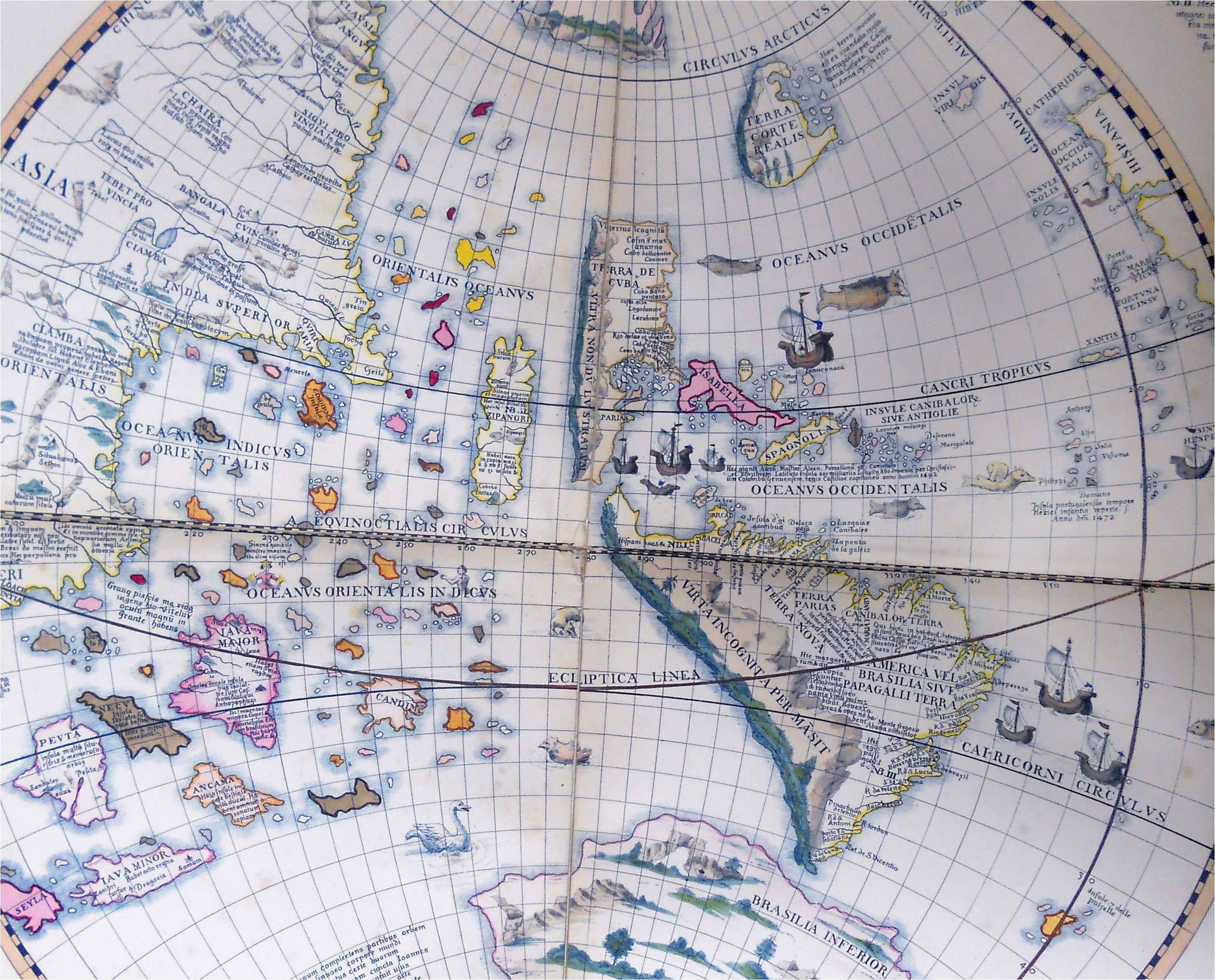
Johannes Schöner’s globe (1520).
If we shift our attention to Magellan's own, more personal, objectives, it is necessary to clarify why he spent so much time and effort in the Philippines rather than heading directly to the Moluccas. According to the Agreement signed by the King of Spain and Fernando de Magellanes in March 1518 at Valladolid, the first six islands discovered by the expedition would belong to the Crown.
32
If the expedition were to discover more than six islands, the King would select six for himself first and then Magellan could choose two, where he and his business partner, Rui Falero, could set up a warehouse and obtain revenues. This understanding was not a secret, and it was also reported verbatim in the instructions given to one of Magellan's great enemies in the fleet, Juan de Cartagena. In particular, the document signed by the King stated: Moreover, it is our will and pleasure that if the islands, which you [Magellan and Falero] shall discover in this manner, exceed six in number, having first chosen six [for us], you may assign to yourselves two of those that remain.
33
Having clarified the objectives of the voyage, it is possible on this 500th anniversary of its completion to evaluate its achievements. After difficult months in the Atlantic and along the coast of South America, where Magellan had to ruthlessly put down a mutiny by Spanish officers who were unhappy with taking orders from a foreigner, the fleet approached the end of the American landmass in October 1520. Here, the strait was discovered in the midst of a storm. Carefully exploring the different passages and dangerous waters of the maze of land and sea forming the strait, Magellan was able to guide his fleet to the other side. Some European geographers, underestimating the size of the Earth, had formed in their minds and represented on their maps the hypothesis of a small sea connecting the Americas to Japan and China, and of course the Spice Islands. But what Magellan and his men discovered was the Pacific, the largest stretch of water on the planet, and a vast and apparently endless ocean for which they were materially and psychologically unprepared. With his men suffering from starvation, dehydration, scurvy and despair, Magellan pushed through, sailing for a while along the coast of Chile, and even when he turned west, he did so well above the latitude of the Moluccas.
Due to the limited space and scope of this contribution, I will here only note that after exploring the Philippines, baptizing many natives, initiating trading relations and forming an alliance with the chief of Cebu, Magellan was eager to demonstrate Iberian military skills. On 27 April 1521, his involvement in local politics would cost him his life, as he was killed during a battle on the beach of Mactan, a nearby island whose chief had refused to submit to Cebu. As Juan Sebastián Elcano (1476–1526) sarcastically remarked, Magellan had died ‘to make the king of Mactan kiss the hands of the king of Cebu, and because he did not send him a bushel of rice and a goat as tribute’. 35
From that moment, his crew would begin wandering around the archipelago, without a leader and without a clear objective. One of the ships had to be burned for lack of men. Slowly, the survivors made their way to the Spice Islands, visiting several markets and sophisticated societies including Brunei, and in November 1521 they finally anchored at Tidore, an island producing enormous quantities of cloves. From there, the two remaining ships separated: the Trinidad attempted to go back to Spain by way of the Pacific and Mexico, but met with heavy storms, was damaged, and in the end had to return to the Moluccas and surrender to a Portuguese fleet; most of its men were arrested and forced to labour for many years, never seeing Spain again.
The other ship, the Victoria, commanded by Elcano, crossed South Asia, constantly hurrying onwards and afraid of being intercepted by Portuguese warships. Taking a southerly route across the Indian Ocean precisely to avoid the Portuguese – whose officers in India had been alerted and knew about the presence of Spanish intruders – this ship eventually rounded the Cape of Good Hope and found its way back to Seville. A handful of famished, sick and exhausted survivors completed the circumnavigation of the globe by entering the port of Seville on 6 September 1522. They immediately proceeded to walk barefoot, each man holding a lighted candle, to the church of Santa María de la Victoria, to do penance for their sins and thank the Virgin Mary. 36
What had ultimately been accomplished? Little of what either the Spanish monarchy or Magellan had hoped. After all, as succinctly put by Carla Rahn Phillips: Although Magellan had discovered that route, it was not viable without the knowledge of how to return across the Pacific. Otherwise, any Spanish voyages that reached Asia would remain at the mercy of the Portuguese, who had established several bases in Asia.
37
Nevertheless, if we forget about the geopolitical and personal objectives for a moment, we can argue quite compellingly that the Magellan–Elcano voyage was the crowning achievement of the first phase of European exploration. Of course, following the Magellan–Elcano expedition, the Europeans learned of the existence of the Marianas and the Philippines. But, more importantly, Magellan found the strait that so many captains after Columbus had looked for. This strait proved that all the oceans of the world are one. Crucially, Magellan's determination to push through the dangerous waters of the strait and his extraordinary seafaring skills across the Pacific contributed to a more accurate measurement of the Earth – a major correction of Ptolemaic geography and contemporary European cartography.
Yet this intellectual adjustment was not only cartographic; it was also cosmographic and cosmological. To appreciate this, we should remember that, only 60 years earlier, the beautiful mappa mundi produced by Fra Mauro in Venice still represented the known continents as surrounded by the forsaken islands and the tenebre – a vast area of impassable darkness that limited human mobility. 41 This visualization of space and the cosmos had serious implications also for the metaphysical position of human beings. 42 According to Angelo Cattaneo, even though Fra Mauro greatly expanded the navigable seas on his map, he maintained the ocean's role as the physical and metaphysical limit to human action and knowledge. 43 Even as late as the Cantino map (1502), the idea of measurable physical distances in a finite world open to the possibilities of uninterrupted (circum)navigation was arguably absent. 44 After the Magellan–Elcano expedition, this perception of the cosmos changed and, in a map like Diogo Ribeiro's 1529 update of the Padrón General (Figure 2), we finally see not only the contours of most of the continents but also the end of a first phase in the process of European maritime exploration.
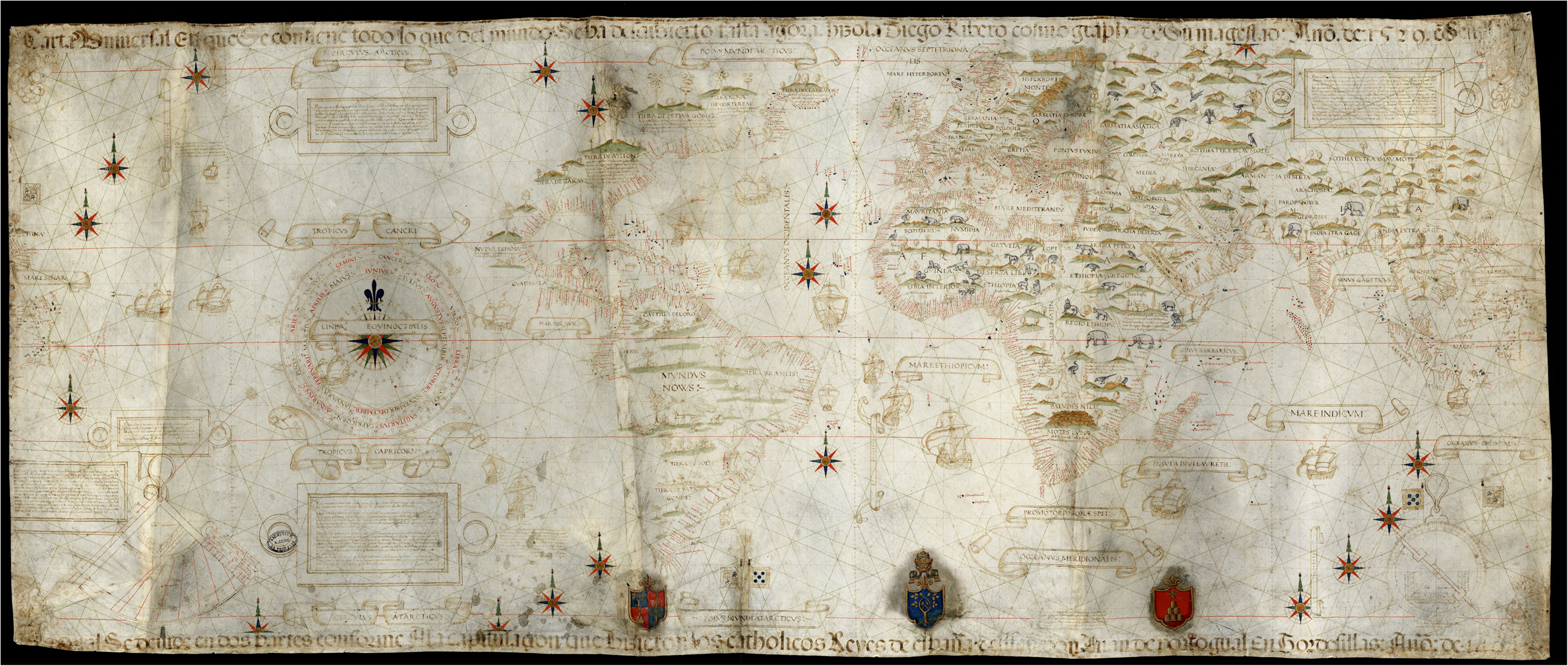
Diogo Ribeiro’s Padrón Real (1529).
A sense of closure can also be perceived in the words of Maximilianus Transylvanus (c.1490–1538), who, soon after the return of Elcano and the other survivors, authored an account of the expedition based on interviews. In the introductory section of his work, ‘De Moluccis Insulis’, he declares: ‘the Castilians in their voyages westwards, and the Portuguese sailing eastwards, have sought out, discovered, and surveyed so many places even beyond the Tropic of Capricorn, and now these countrymen of ours have sailed completely round the world’. 45 Similarly, Elcano himself stressed the idea of the completion of a historic process of discovery in a letter to King Charles, writing: ‘Furthermore Your Majesty will know that what we should especially appreciate and value is that we have discovered and encompassed the whole circle of the world, since going west we returned from the east’. 46
Even though Spain could not immediately take advantage of these discoveries from a political perspective, the voyage was consequential from a geopolitical point of view precisely because it tested the limits of Charles's universal monarchy and influenced the shape of Iberian Asia. According Transylvanus, this voyage had been planned precisely to ascertain the gap between geographic reality and Habsburg claims to a universal monarchy: And although there was a somewhat doubtful rumour afloat, that the Portuguese had advanced so far to the east, that they had come to the end of their own limits, and had passed over into the territory appointed for the Castilians, and that Malacca and the Great Gulf were within our limits, all this was more said than believed, until, four years ago, Ferdinand Magellan, a distinguished Portuguese, who had for many years sailed about the Eastern Seas as admiral of the Portuguese fleet, having quarelled with his king, … and Christopher Haro … pointed out to the emperor, that it was not yet clearly ascertained, whether Malacca was within the boundaries of the Portuguese or of the Castillians, because hitherto its longitude had not been definitely known; but that it was an undoubted fact that the Great Gulf and the Chinese nations were within the Castilian limits.
47
Images of Asian islands and societies in Pigafetta's Relazione
Before air and rail travel, long-distance cross-cultural encounters happened mostly thanks to maritime voyages, and indeed Magellan's expedition was momentous also because of the images of Asian societies that it popularized across Christendom. Among the few survivors of the enterprise was Antonio Pigafetta (c.1492–1531), a nobleman from Vicenza. He had joined the expedition through curiosity and a desire for fame. After his return in Europe, he travelled round several Renaissance courts, attempting to make a name for himself as an expert on ‘the Indies’, and eventually wrote a book entitled Relazione del primo viaggio intorno al mondo. This text, besides being an example of Italian courtly literature that harmoniously merges medieval and Renaissance themes and values, marked an expansion in ethnographic, anthropological and linguistic knowledge. 49 In its original format, it also included an isolario or ‘Book of Islands’, which allowed the reader to visualize Asian spaces for the first time not through broad cartographic conjectures but through 23 detailed charts of the eastern archipelagos touched by the expedition. 50
The Relazione became very popular during the sixteenth century and, far from embodying an arrogant imperialist attitude or a rapacious obsession for spices and gold, it is actually a sensitive and colourful narrative that weaves together chivalric themes and sympathetic descriptions of Asian societies. Pigafetta does not condemn even the most unexpected or strange customs, and he often leaves his explanations of peculiar rites and traditions open-ended. He does this, for example, when detailing funerary rites and the ceremonial killing of swine in the Philippines, avoiding judgement and inviting the reader to draw their own conclusions. 51
Pigafetta's keen interest and respect with regard to Asian societies is shown by his sober and delicate description of the relatively simple courtly life at Mindanao in the Philippines.
52
Even though his visit there takes place after both the death of Magellan at Mactan and the subsequent massacre of many members of the crew at Cebu, Pigafetta depicts the local king as charming and amiable, and gives the reader an impression of tranquillity, as if he found himself among old friends: At the conclusion of dinner, I asked the king by signs whether I could see the queen. He replied that he was willing, and we went together to the summit of a lofty hill, where the queen's house was located. When I entered the house, I made a bow to the queen, and she did the same to me, whereupon I sat down beside her. She was making a sleeping mat of palm leaves. In the house there was hanging a number of porcelain jars and four metal disks for playing upon, one of which was larger than the second, while the other two were still smaller. There were many male and female slaves who served her. … Having taken our leave, we returned to the king's house, where the king had us immediately served with refreshments of sugarcane.
53
Another example of how Pigafetta (and his audience) perceived Asian maritime civilizations comes in his account of an encounter between two Moluccan kings, the Sultan of Tidore (who was hosting the remnants of the Spanish fleet and whom Pigafetta calls ‘our king’) and the Sultan of Batjan (Bacan). The impressive scene is recalled in the following description: On Sunday afternoon, December 15, the king of Batjan and his brother came in a prau with three tiers of rowers at each side. In all there were 120 rowers, and they carried many banners made of white, yellow, and red parrot feathers. There was much sounding of those metal disks, for the rowers kept time in their rowing to those sounds. He brought two other praus filled with girls to present them to his betrothed.
55
Our king came to congratulate him as it is not the custom for any king to disembark on the land of another king. When the king of Batjan saw our king coming, he rose from the carpet on which he was seated, and took his position at one side of it. Our king refused to sit down upon the carpet, but on its other side, and so none occupied the carpet. The king of Batjan gave our king five hundred patols, because our king was giving his daughter to wife to the former's brother. The said patols are cloths of gold and silk manufactured in China, and are highly esteemed among them. Whenever one of those people dies, the other members of his family clothe themselves in those cloths in order to show him more honor.
56
There are other examples of Pigafetta's sensitivity to evidence of civility and political legitimacy, as well as his interest and empathy towards the rites and traditions that he encountered during the voyage. 57 But suffice here to say that the dissemination of such images of Asia across Cinquecento Italy and Europe responded to a long-standing and genuine curiosity about the world – a curiosity that characterized late medieval Christendom. 58 The significance of Magellan's voyage, from this perspective, is that it concluded an important phase of an enterprise that was not merely political or economic, but also intellectual; the expansion of the sphere of human mobility resulted in a correction of physical and human geographies.
As clearly exemplified by Gian Battista Ramusio’s premise for his famous 1550 collection of travel accounts, late medieval and Renaissance humanists had embarked on a quest to participate in, integrate and harmoniously complete the knowledge of the ancients: But the reason that made me willingly undertake this work was that, studying the tables of the geography of Ptolemy where Africa and India are described, and considering them very much defective, I thought it would be appreciated and quite useful to the world to put together the narratives of the writers of our times, who have visited and discussed in detail the abovementioned parts of the world, with which juxtaposing the information in the Portuguese maritime charts, it would be possible to draw new tables … contributing to what has been written by the ancient authors.
59
Conclusion
On the 500th anniversary of the Magellan–Elcano voyage around the world, whose few survivors returned to Seville aboard the Victoria in September 1522, this article has offered a reassessment of the political context within which both Columbus and Magellan moved. While the historiography tends to see the Treaty of Tordesillas as a turning point, I have explained the importance of a longer history of rivalry and diplomatic cooperation between the Iberian kingdoms in the Atlantic. The 1479 Treaty of Alcáçovas constituted the true cornerstone of the Iberian world, determining, in broad strokes, geopolitical spheres and future routes of maritime exploration.
Second, it is necessary to reconsider the multiple achievements of the Magellan–Elcano expedition, beyond the mapping of the strait. Contrary to what is assumed even by recent scholarship on the subject, I have clarified why there is no mystery surrounding the northerly route followed by Magellan across the Pacific. I have concluded that even though the route across the Pacific remained unviable for many decades, a new conception of the size and shape of the world emerged, giving a sense of closure to the first phase in the opening of the Atlantic world and altering the very metaphysical position of human beings in European cosmography. This change was quickly absorbed in cartography as well as the minds of both Transylvanus and Pigafetta. 61
Pigafetta, a restless nobleman from Vicenza who was enamoured with the chivalric figure of Magellan, has been the subject of my third reflection. As already observed by Gabriel García Márquez, Pigafetta's Relazione is the literary masterpiece of its age. 62 Rather than just abstract ideas about a navigable but shapeless sea encompassing the Earth, European audiences devoured entertaining, puzzling and overall empathetic images of specific human geographies. Crucially, then, the most important account of Magellan's enterprise shows how, even in a context such as Iberian expansion, European curiosity played a key role in long-distance maritime travel and East–West encounters.
Footnotes
Acknowledgements
I am grateful to the participants at the symposium ‘All the Oceans Are One: Magellan's Voyage on Its 500th Anniversary’, hosted by the School of International Studies at the University of Nottingham Ningbo on 5 January 2022, where I presented an earlier draft of this article.