
Abstract
Facing significant challenges in terms of access to open space and urban heat, Paris is pedestrianizing entire streets in front of schools at a significant scale. This study comprehensively evaluates Paris’s School Streets (“Rues aux écoles”) via a combination of field collection (including visits to all 272 active sites), and analysis of high-resolution satellite and street-view imagery. Over fifteen years, Paris has pedestrianized 13.5 km (8.4 miles) of streets, creating 15.7 ha (38.9 acres) of open space. Analyzing surface temperature of School Streets with cooling pavement, in comparison to adjacent “Control Streets,” detects average temperature differences of 5.01°C (9.02°F).
Introduction
Redesigning streets around the needs of children, parents, pedestrians, and cyclists—as opposed to automobiles—can potentially mitigate many urban challenges, such as lack of open space and vegetation, and the heat-island effect (Greenwalt, Martino, and Estratégico 2021; I. D. Stewart and Mills 2021). Paris, the capital of France and a city of roughly two million, has pursued this strategy via the implementation of “School Streets,” wherein streets adjacent to schools are pedestrianized; the space previously taken up by parked and moving cars is converted into a place for children to play, parents to gather before and following the school day, pedestrians and cyclists to travel through, and residents and patrons of local businesses to linger and enjoy (see Figure 1).
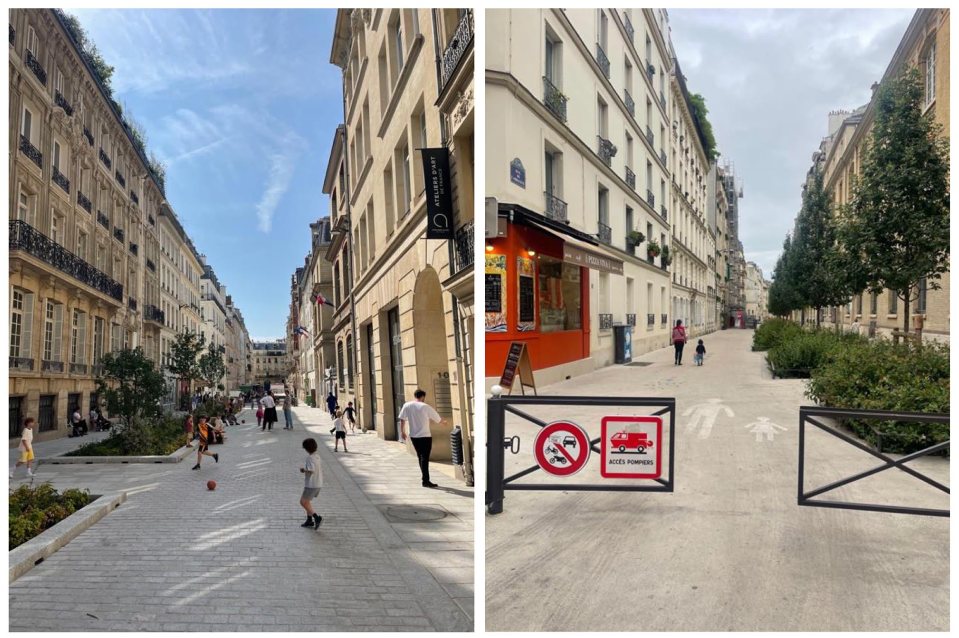
School Streets in Paris (Rue Chaptal, left, and Rue de l’Arbalete, right).
In the context of changing uses of urban streets internationally, School Streets are informed by, and relate to a number of other prominent schemes, including the Super Blocks of Barcelona (Mueller et al. 2020), Low-Traffic Neighborhoods of London (Laverty, Aldred, and Goodman 2021), and Woonerfs of the Netherlands and Belgium (Gameren and Mooij 2010). Each of these programs entails traffic restrictions, inclusion of pedestrian and bike-friendly infrastructure, and increased vegetation and landscaping, though they differ in number per city, spatial scale of each intervention, and installation timelines. Given the novelty of Paris’s School Streets, it is essential that street pedestrianization on this scale—as of summer 2025 there are over 250 School Streets across Paris—be systematically analyzed, including cataloging of design differences, spatial distribution, sequencing and timing, and potential environmental benefits, such as decreased surface temperatures (relative to adjacent “Control Streets”). Given that, the three specific research questions pursued are as follows. First, what has been the spatial and temporal expansion of School Streets in Paris, including their geographic arrangement, length, size (in area), and installation year? Second, how do these School Streets vary in terms of design, level of investment, and features present (such as seating and landscaping), particularly given existing public discussion of the program rarely captures these streets’ heterogeneity? Third, for those School Streets in which cooling pavement has been applied, if and to what extent are there detectable temperature differences, compared to adjacent, control streets?
In order to answer these questions, this study combines both in-person visits to every School Street in Paris, with review of high-resolution satellite and street imagery. In doing so, it generates a uniquely-comprehensive picture of their spatial extent, roll-out over time, variance in design and size, and potential environmental benefits. More broadly, it advances scholarship on redesigning the public right of way to support uses beyond automobile travel and storage via a novel and globally-relevant case study, adding crucial context to Paris’s School Streets which will be relevant to urban planners and designers.
Literature Review
School Streets sit on a wide spectrum of interventions that re-purpose the public right of way for the benefit of non-car travelers. This ranges from the simplest form of traffic calming—such as removing parked cars adjacent to crosswalks (Duncan et al. 2016)—to complete pedestrianization of a street by fully prohibiting car entry (Hussein 2018). Indeed, School Streets explicitly encompass a transition in the use of such public space (from car-centric to pedestrian-centric), as opposed to promenades which are designed to be car-free from scratch (Jamme et al. 2024; Macdonald 2017). Given this, some scholars employ the term “reclaiming” streets to clarify that prior to the automobile, urban streets were to a great extent used as places for children to play, and for people to gather and linger (Fotel 2009; Grescoe 2023; Karsten and Vliet 2006).
In the broader context of transportation planning, School Streets can be conceived of as part of the long-term reaction to the increasing, and increasingly fraught, incursion of the automobile into urban life. From mid-twentieth century critics such as Lewis Mumford and Jane Jacobs (Jacobs 2002; Mumford 1958) who noted the severe consequences of expressways replacing condemned neighborhoods, to canonical experiments such as Appleyard’s demonstration that high-speed roads were associated with fewer social connections among neighbors (Appleyard and Lintell 1972), there has been consistent documentation of the negative effects that car-centric planning has on urban life. The decades-long accretion of these negative repercussions (including annual traffic fatalities in the tens of thousands; Culver 2018), has spawned both scholarship and planning responses that seek to lessen the car’s dominance of the public right of way, and instead rejuvenate the social life of streets. This included “traffic-free zones” being piloted starting in the 1960s (Feriel 2020), to more episodic events which temporarily prohibited automobile traffic, such as farmers markets and car-free days across cities (Petrocci 1981; Triana et al. 2019), and contemporary, notable interventions such as the pedestrianization of New York City’s Times Square (Sadik-Khan and Solomonow 2017).
Of course, how we perceive, regulate, and use urban streets is not detached from the rest of society and its changes, but shaped by them. Indeed, street design and related programs received renewed interest, and expansive experimentation in the wake of the COVID-19 pandemic (Douglas and Moore 2022; Zhao, Sun, and Webster 2024), which forced municipalities to grapple with a near-overnight surge in demand for public space in which residents could “socially distance,” and a dramatic decline in car usage while shelter-in-place orders were operative. This included streamlining planning processes and altering standard materials used in order to expedite urban “place-making” in the Spring of 2020, which drew on lessons from grass-roots interventions such as tactical urbanism (Kim 2025; Stevens and Dovey 2022). This significant body of work, however, leaves open an important research gap to fill. Specifically, as the pandemic recedes and cities are no longer under duress to roll out street interventions immediately, what type of infrastructure and design flows from the continued desire for less car-centric streets? Indeed, what distinguishes School Streets in Paris from the types of pedestrianization strategies that have preceded them?
Defined as a street adjacent to a school where automobile traffic is either temporarily or permanently restricted (Snaije and Gutierrez 2022), School Streets have been implemented in a number of cities, including London, New York, Barcelona, and Vienna, among others (Clarke 2022; Honey-Rosés et al. 2023; Mosshammer 2023; D. Stewart 2024; Thomas 2023). These interventions vary significantly in terms of design, materials used, and timing; indeed, School Streets in many cities are only active during specific times of the day, such as in the morning during student drop-offs, mid-day recesses, and/or afternoons when students are picked up (L. E. Smith et al. 2022). Given this, Dostal (2025) created a typology of School Streets that reflects their temporal range, with the difference among types primarily relating to the degree to which car traffic is restricted over time.
In Paris, School Streets currently proceed in a stepped fashion (Eckerson 2024). First, a public meeting is hosted by representatives from the City of Paris for residents and merchants in the area where a School Street is planned (Penalosa 2025). Such a meeting is a chance for information to be shared on the Rues aux écoles program generally, as well as specific design considerations for the street in question. This meeting is also an opportunity for the community to convey their concerns and suggestions to planners. Next, phase I of School Streets entails the installation of swinging metal gates, which close each end of the street off from automobile traffic, though allow access for emergency vehicles, such as firetrucks. Beyond that, very few other changes are made at this point, other than signage at the entrance to each side of the School Street, and (at times) a stencil of an adult and a child on the street pavement (see Figure 2).
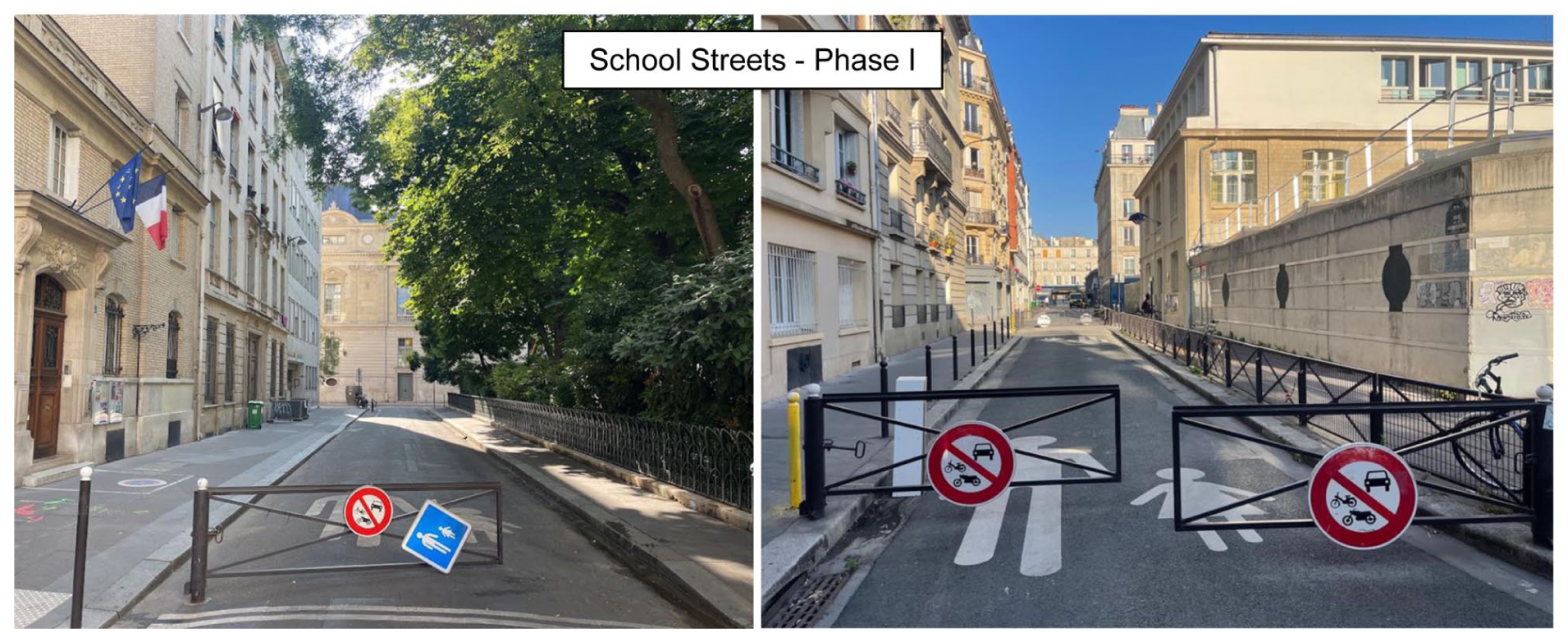
Phase I of School Streets in Paris, in which swinging gates, attached signage, and pavement stencils are installed (Rue du Louvois, left, Rue de la Guadeloupe, right).
Next, following a second community meeting, and in the absence of significant pushback (two such cases have occurred; Penalosa 2025), School Streets transition to a more established phase II (see Figure 1). This entails grading the street to be level, sealing the pavement with light-reflecting material to reduce surface temperatures, and adding a number of features, including trees, vegetation (such as flowers, bushes, ferns), moveable planters, seating of different kinds and sizes (including those specifically sized for children), bicycle parking, water fountains, and artwork or other child-friendly pavement markings (such as “hop-scotch” arrays; see Figure 3). School Streets also involve live programming, such as toy and game lending “libraries” where children and parents may check out equipment from a supervised, on-site storage locker. In addition, School Streets are used for neighborhood events writ large, such as during an annual, citywide festival (‘Fête des rues aux enfants’; Herrada 2024). This current template for School Streets’ progression (phase I, phase II) was initiated in 2020, though a number of pedestrianized streets adjacent to schools from years prior are also included in the city’s running total for the program (STA 2023).
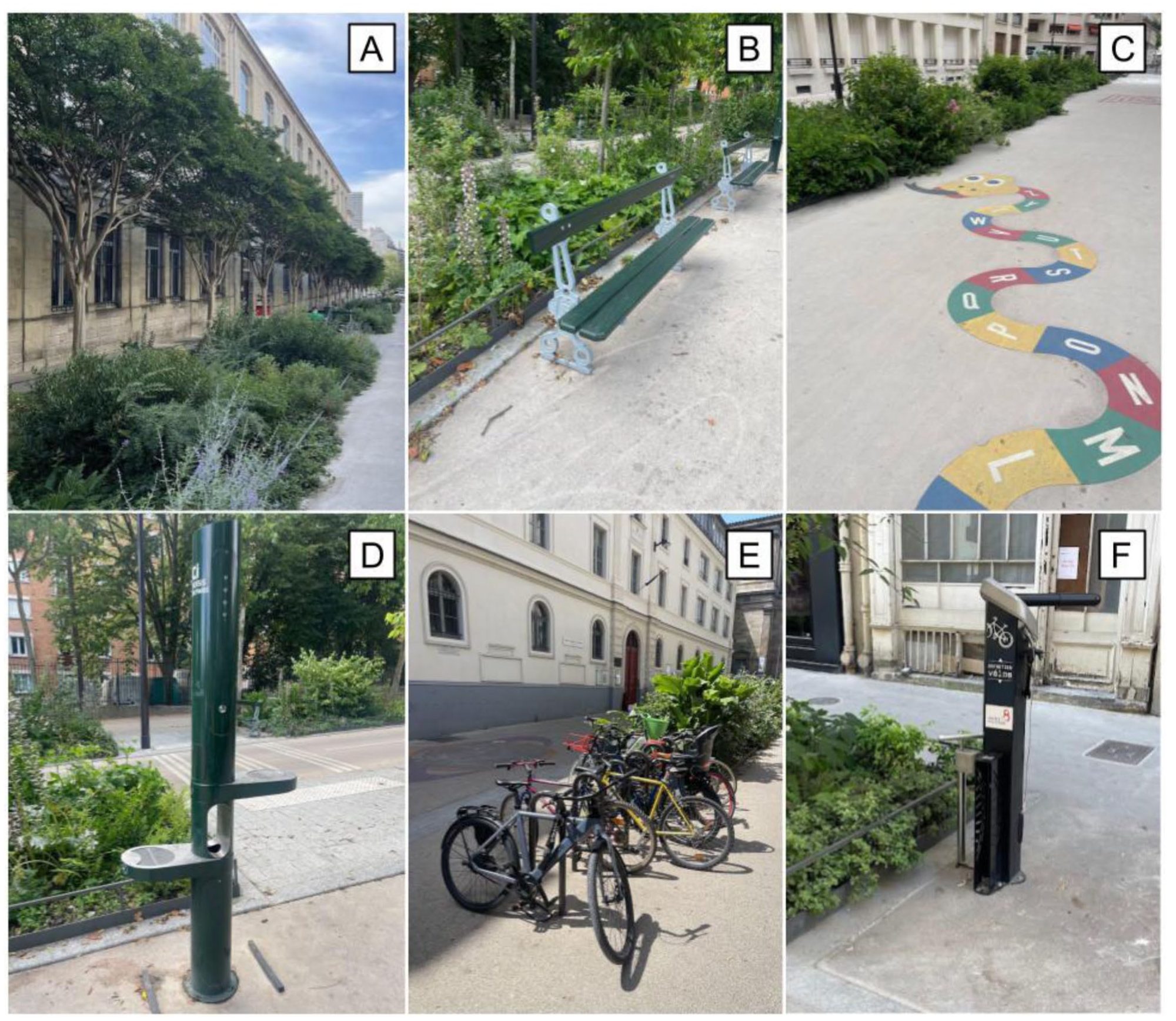
Features installed at School Streets in Paris as part of phase II, including (A) trees and landscaping, (B) seating, (C) cooling pavement and child-friendly markings, (D) water fountains, (E) bicycle parking, and (F) bicycle-repair stations (all photos by the author).
According to staff from City Hall, phase I of School Streets (swinging metal gates on each side of the side, signage, stenciling) costs roughly $10,000, and phase II (including landscaping, repaving, grade-leveling, additional features, etc.) costs roughly $400,000 (Penalosa 2025). School Streets are not planned for any streets which include a bus route or a supermarket. During the implementation of School Streets, municipal staff collaborate with teachers at adjacent schools to build related lesson plans for students, and even include children in landscaping activities.
To date, planning practitioners and academics have probed School Streets programs from a variety of perspectives, both qualitatively and quantitatively, including the social, design, and environmental changes they have contributed to. This has included investigations of their reception from different urban constituencies, as well as their potential impact on air quality (specifically local air pollutants), and active travel (walking and bicycling). Transport for London commissioned a survey of parents regarding School Streets, finding that 81 percent of respondents felt such an intervention was suitable for their child’s specific school (Den Hond et al. 2020; Noble et al. 2021). For those with children enrolled at campuses already adjacent to School Streets, 18 percent of respondents reported driving less for school pick-ups and drop-offs. A multi-city survey (fielded in Brussels, Barcelona, London, Paris, and Warsaw) found that 71 percent of respondents supported the closing of streets in front of schools to cars, at the very least during school pick-ups and drop-offs (Kantar Public 2022). A UNICEF survey of parents in France found that 87 percent supported a School Street adjacent to their child’s school (Martelli-Banégas, Desreumaux, and D’Adamo 2020). An analysis of the political and social factors in favor of School Streets found that the COVID-19 pandemic generated a policy window for the practice to rapidly spread, stemming from an increased desire for open space (and the need to “socially distance”), as well as being exposed to the counterfactual of cities and streets with dramatically reduced automobile traffic (STA 2023).
A small number of studies have probed potential air-quality benefits from School Streets’ implementation. In London, thirty mounted air-quality sensors were installed both on School Streets and on “Control Streets” where no interventions were made but were comparable in other ways (Gellatly and Marner 2021). This set-up detected 5 percent daily reductions in nitrogen oxides on School Streets. However, the authors note that the study taking place during the heart of the COVID-19 pandemic meant that the large disruptions in travel behavior generally likely serve as confounding factors (Batty et al. 2021). A similar study of School Streets in the Flemish region of Belgium detected 20 percent declines in nitrogen oxides (Den Hond et al. 2020). In Paris, the first evaluation of air-quality benefits of School Streets documented a drop in nitrogen oxides by 30 percent around ten locations, though there were not evident declines in particulate matter (Renard 2023). Nitrogen oxide declines surrounding Barcelona’s School Streets registered between 2 and 7 percent (Honey-Rosés 2023).
There are, as of yet, no existing studies which measure the potential cooling benefits of School Streets. Urban heat is a complex phenomenon, influenced by prevailing weather patterns, climate, and elevation (Cheval et al. 2024), as well as features of the built environment such as the amount and density of impervious surfaces (Ma and Peng 2021), and air circulation based on street width, building height, and street orientation (Cui et al. 2023; Salameh, Elkhazindar, and Touqan 2023). In the context of School Streets in Paris, there are potentially three changes that may influence temperature: the addition of trees and landscaping, the installation of cooling pavement, and the removal of parked cars.
Outside of street-pedestrianization projects specifically, satellite imagery has been used extensively to investigate urban questions, including in the realm of transportation. Historical street imagery from Google Maps (Anguelov et al. 2010), available in some locations for over a decade, has been mined to evaluate longitudinal changes to urban form and street layouts (Gullon et al. 2023; Moran 2023). Although currently small in number, there is also a growing body of work deploying handheld and drone-mounted thermal cameras/sensors to measure temperature differentials in urban environments (Chui et al. 2018; Henn and Peduzzi 2024). Given this context, this study will expand existing research on School Streets by generating a comprehensive picture of one such city’s large program, and by leveraging both handheld sensors and satellite imagery, evaluate its potential effect on mitigating the pressing issue of urban heat islands.
Methods
This study probes Paris’s School Streets in multiple ways, both in person and via analysis of satellite and historical street imagery.
In-Person Field Collection
During the summer of 2025, all 272 School Streets in Paris were visited in person. Each visit entailed the use of a survey instrument loaded on a smartphone to collect the presence or absence of the following features: car-restricting infrastructure (e.g. bollards, swinging gates), trees and landscaping (including moveable planters), seating (both adult and child-size), bicycle parking, water fountains, level grading, and cooling pavement. The survey was designed to minimize subjective ratings (e.g. “rate in quality from 1-10”), and instead to capture the specific range of features present or not at each School Street. Each visit occurred on foot, and included walking from one end of the School Street to the other, in order to ensure cataloging the full range of features. In that vein, multiple photographs were taken at each School Street. All gathered information was subsequently exported from the survey instrument, incorporating the latitude and longitude coordinates of each School Street, to be analyzed within GIS software. Visits occurred during daylight hours over the course of June and July 2025, which included a range of activity on these streets, such as school drop-offs and pick-ups (the school year runs until early July in Paris), classes leaving for or returning from outdoor activities, and a large number of Parisians unaffiliated with these schools making use of the streets (dining at adjacent cafes, sitting on benches, walking dogs, etc.). Deciding which features to note the presence or absence of during field collection was based on existing research on School Streets (Andres et al. 2025; Bianchi and Moscarelli 2024; L. E. Smith et al. 2022), which emphasized the relevance of barriers at each end to deter car traffic, the addition of landscaping and vegetation to improve the urban environment, and the inclusion of seating, and child-friendly touches (such as pavement markings) to make these spaces more inviting.
In addition, every School Street where cooling pavement has been installed—which presents as a tan/light brown color relative to darker asphalt—was further photographed using a specialized thermal camera (FLIR One Pro; Alexander and Lunderman 2021), as was standard pavement on an adjacent “Control Street” for comparison. This device provides a temperature reading for surfaces within its field of view, and images can be exported for in-depth temperature analysis (see Figure 4). For optimal comparison purposes, Control Streets were directly adjacent to School Streets, and in the same orientation (i.e. parallel) in order to ensure as similar sun exposure, shading, and wind flow as possible. Furthermore, thermal imagery was acquired at roughly the same time for both the cooling pavement on School Streets and standard pavement on Control Streets (minutes apart during field collection). Lastly, images of a School Street and Control Street pair were taken either in full sun or in full shade, depending on the time of day, surrounding buildings, and orientation of the streets.
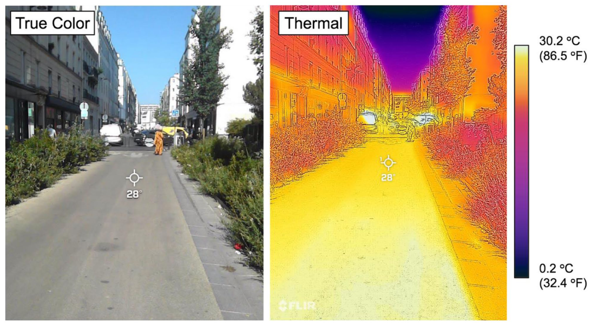
True color (left) and thermal imagery (right) of cooling pavement on a School Street in Paris (Rue Championnet, photos by the author using the FLIR One Pro camera).
Historical Street Imagery
Street-view imagery within Google Maps was reviewed for all School Street locations in Paris, in order to determine in which year each was first pedestrianized (e.g. the installation of traffic-restricting infrastructure). Furthermore, historical street imagery was reviewed to note the timing of the sequencing of each School Street from phase I (swinging gates, signage, and pavement stencils) to phase II (level grading, landscaping, street furniture, cooling pavement, etc.). For example, Rue Charles Baudelaire was not pedestrianized in any way as of 2020, by 2021 it had progressed to phase I, featuring swinging gates, signage, and pavement-stencil markings, and by 2022 it was transitioned to phase II, featuring level grading, trees, plant beds, and cooling pavement (see Figure 5). This review of street imagery thus generates a timeline of School Streets’ expansion across Paris, not only in terms of the first pedestrianization step, but also more-expansive streetscape investments.
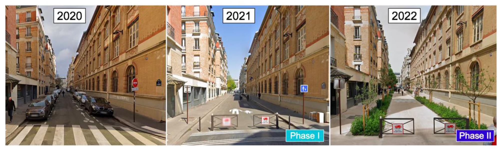
Progression of School Street phases at Rue Charles Baudelaire (photos drawn from Google Maps).
Satellite Imagery
Lastly, satellite imagery was reviewed for all School Streets within Google Earth, in order to measure their total length and area (see Figure 6). This was undertaken with imagery from 2024, meaning that it included a mix of School Streets in both phases I and II.
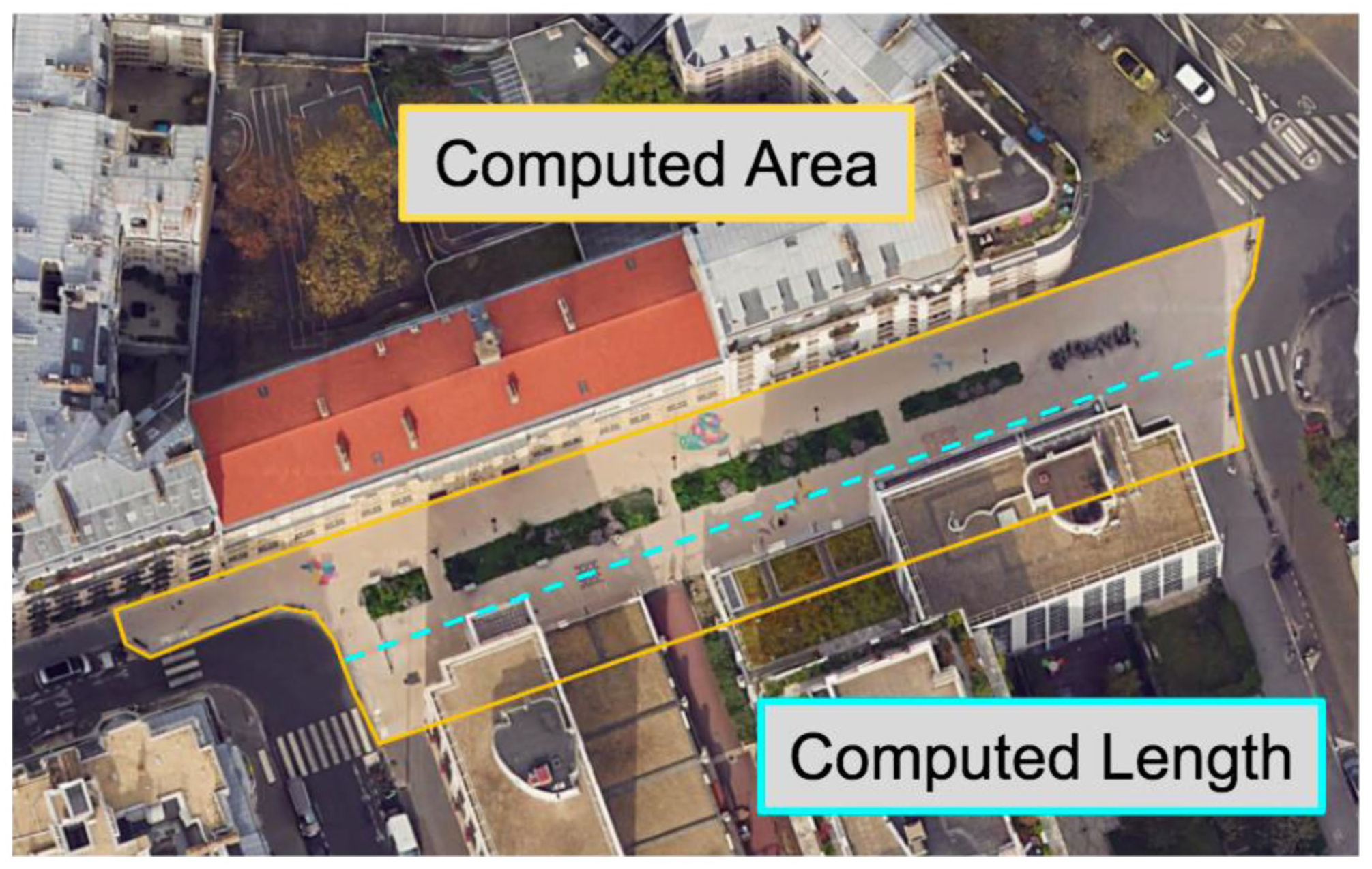
Satellite imagery of a School Street in Paris, outlined in order to calculate its area and length (top, Rue Eblé, image drawn from Google Earth).
Results
In-person visits to all 272 School Streets in Paris, as well as review of satellite and historical street imagery demonstrates an expansive and heterogeneous street-reclamation program. These mixed methods determined that there are currently four distinct categories of School Streets in Paris; first, there are fifty-nine pedestrianized streets that were established prior to 2008 (22% of the total), the earliest year historical street imagery is available for Paris within Google Maps. These long predate the current “Rues aux écoles” program, and are here after labeled as “longstanding” School Streets. Second, there are seventy-five School Streets which consist primarily of traffic-restricting gates, signage, and pavement stencils, which (as noted above) are referred to as phase I (27% of the total). Third, there are seventy-nine School Streets with more significant investments made, including landscaping, seating, bicycle parking, level grading, and cooling pavement (among other features), referred to as phase II (29% of the total). Finally, there are fifty-nine School Streets where no physical barriers to automobile traffic have been erected, though they often include signage and pavement stencils, and are included in the city’s running list of the program, and which are hereafter referred to as “Open to Cars” (22% of the total).
Designating these four categories of School Streets allows for analysis of their spatial distribution across Paris (see Figure 7). This map illustrates that School Streets have been established fairly evenly across the city, though a few large gaps remain, particularly around the Champs-Élysées, Place de la Concorde, Les Invalides, and Champ de Mars (adjacent to the Eiffel Tower), though that is potentially a function of those areas being dense in civic institutions, tourist attractions, and large parks, entailing a smaller number of potential sites for School Streets. Furthermore, phase II School Streets, where greater investment has occurred, are primarily located in more outlying sections of Paris, as opposed to the city center. This may be a function of School Streets in the first to sixth arrondissements being more difficult to pedestrianize, given higher traffic and delivery volumes. Specifically, spatially joining all current School Streets to the arrondissement in which they are located demonstrates a contrast between those within “inner” Paris (for these purposes, the first to sixth arrondissements), and “outer” Paris (the seventh through twentieth arrondissements). Indeed, the forty School Streets in inner Paris were 18 percent longstanding, 28 percent open to cars, 40 percent phase I, and 15 percent phase II, whereas the 232 School Streets in outer Paris were 24 percent longstanding, 21 percent open to cars, 24 percent phase I, and 31 percent phase II.
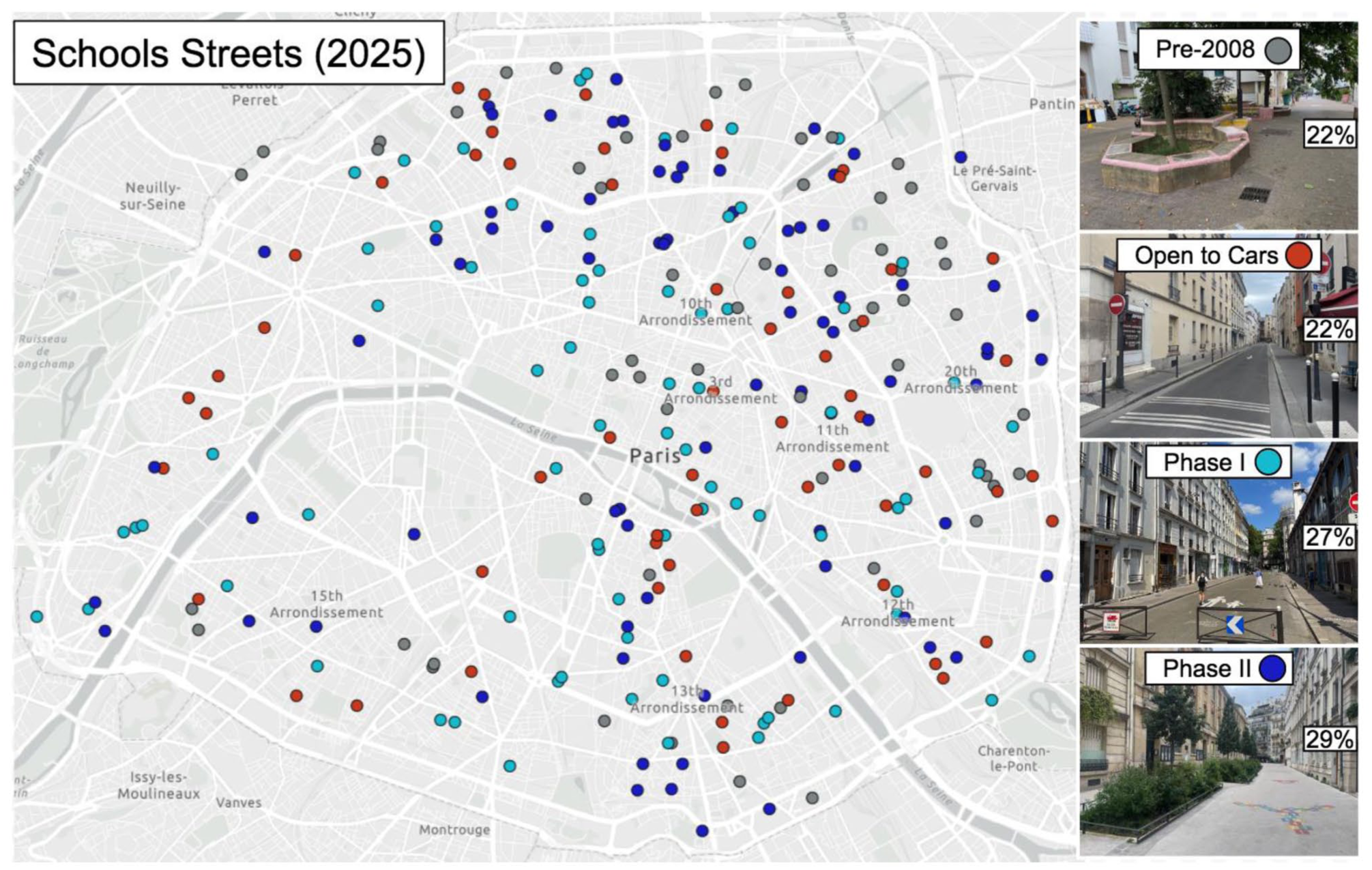
Map of School Streets in Paris, colored by status (gray: installed prior to 2008, red: open to cars, teal: phase I, blue: phase II).
Finally, this map highlights that a number of School Streets have been co-located; blocks with connecting or adjacent School Streets are present in a number of cases, which generate a larger sense of pedestrianized space than single streets, in some ways comparable to the concept of “Low-Traffic Neighborhoods” implemented in the United Kingdom (Aldred and Goodman 2020).
Cataloging the presence of features across all school streets demonstrates that the most prevalent feature is a swinging gate or set of bollards (at one or both ends of the street) which close the street off from vehicular traffic (71%), followed by trees (65%), bike parking (55%), level grading (51%), landscaping (45%), seating of different kinds (25%), cooling pavement (21%), and water fountains (9%) (see Figure 8).
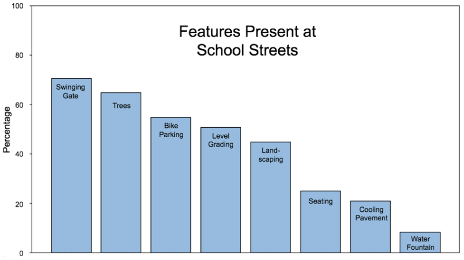
Percentages of School Streets in Paris with the following features (out of 272 total locations).
Review of historical street imagery for all School Streets determined that for those established after 2008, the bulk came between 2020 and 2022, and a second wave between 2023 and 2025 (see Figure 9). Furthermore, these images allow for the calculation of the average time in between a School Street first being established in phase I, and subsequently transitioned to phase II. Across the seventy-nine School Streets which are currently in phase II, there was an average of 2.2 years between phases I and II.
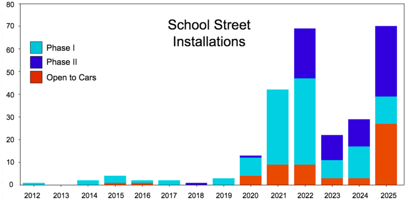
Longitudinal progression of School Street installations, by type.
Across the fifty-seven Schools Streets where cooling pavement has been installed to date, as well as adjacent Control Streets, in-person measurement of pavement temperature with a thermal camera detected an average temperature differential of 5.01°C (9.02°F). The largest such temperature differential measured was 12.2°C (21.96°F) and the smallest was 1.2°C (2.16°F). Furthermore, the average temperature differential for the upper half of Control Street pavement temperatures (6.06°C, 10.9°F), was greater than for the lower half of Control Street pavement temperatures (3.99°C, 7.18°F), suggesting that thermal declines from cooling pavement increase as does the prevailing temperature (see Figure 10).
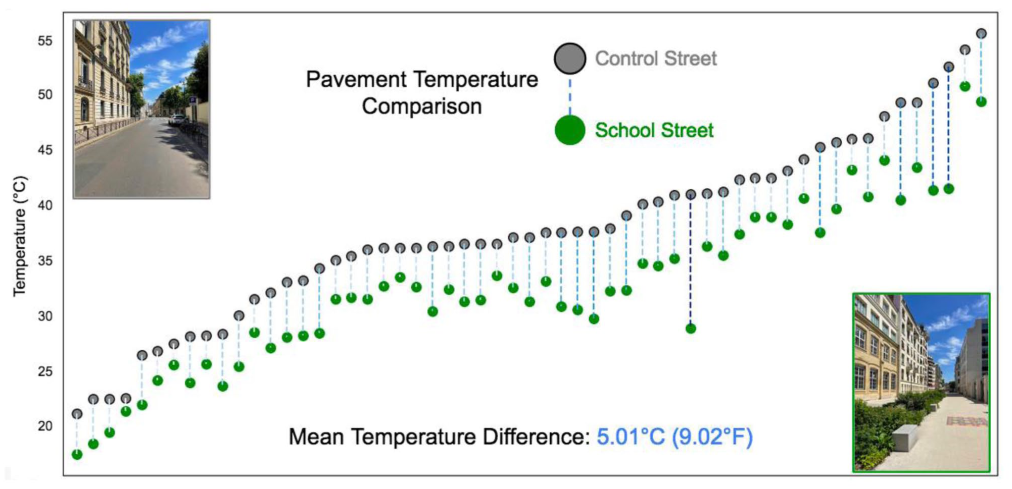
Pavement temperature differences between School Streets and Control Streets (°C), sorted by Control Street pavement temperature.
Satellite imagery analysis calculated that the total distance of streets pedestrianized (excluding those installed before 2008 and those open to cars) is 13.5 km (8.4 miles). In terms of area, School Streets in phases I and II comprise 15.7 ha (38.9 acres). The average School Street is 90 m in length (295 feet), and 0.1 has (0.25 acres).
Discussion
Visits to all School Streets throughout Paris generate themes regarding this pedestrianization program. Indeed, it is both incrementalist and heterogeneous; streets are not converted to leafy, fully-pedestrianized streets immediately (or completely), but primarily begin with the installation of swinging gates, wherein the street’s form is largely otherwise left unchanged. Only following that initial step (phase I), and community consultation, do these streets subsequently receive far more expanded investment (phase II). Moreover, even within these phases, School Streets still vary dramatically from case to case; some leave much of the street open to cars, whereas others stretch for an entire block and even interconnect to adjacent School Streets at intersections. The investment and design acumen, including in tree planting and landscaping, generate the effect of walking along a linear park in some cases, whereas others still include on-street parking, dark asphalt, and few signs of intervention.
Although branded explicitly in connection to schools, in-person visits also clearly demonstrated that a large percent of the users of these pedestrianized streets are unaffiliated with the schools in question, including patrons at adjacent restaurants and cafes, many of which now have far more space for outdoor seating (see Figure 11A). Indeed, because Paris’s program is fixed across hours of the day and days of the week (rather than tied only to pick-ups and drop-offs), these streets serve a wide range of uses and users.
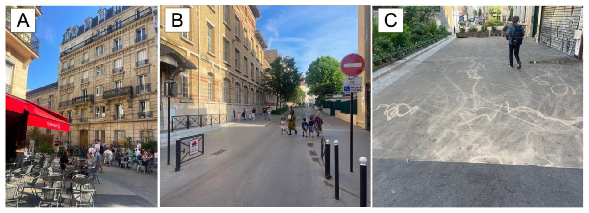
(A) Cafe and restaurant seating within a School Street. (B) Swinging gates left open. (C) Cooling pavement in poor condition.
Of course, field visits also demonstrate some of the shortcomings of School Streets in Paris. Many of the installed swinging gates are not outfitted with locks, which many drivers have learned. Thus, this has led to gates being left open at a large number of School Streets, which reduces their sense of enclosure for potential users, and raises the chances that drivers will impede (see Figure 11B). Furthermore, School Streets can (and do) suffer from many of the same challenges that plague car-centric streets: debris, litter, vegetation in need of mowing or pruning, and trash cans in need of being emptied (see Figure 11C).
In comparison to other prominent street-pedestrianization programs, there are several distinguishing features of Paris’s School Streets. First, though the design and materials used in phase I could be considered a form of “tactical urbanism” (installed quickly and cheaply), the significant investments made into these streets during phase II, including level grading, extensive landscaping, and the installation of seating and bike parking indicates a far more exhaustive and long-term vision for these blocks. Indeed, a shared attribute of tactical urbanism or “urban acupuncture” is that it can be reversed quite quickly if it is deemed inappropriate. Relative to “Low-Traffic Neighborhoods,” popularized in the United Kingdom, School Streets in Paris are also primarily bounded to a single block of a street in question, rather than traffic calming that is distributed in concert across a set of connected streets. Furthermore, relative to the Super Block approach of Barcelona (and others), School Streets rarely disrupt or limit traffic throughout entire intersections, or intersect with each other, which results in less extensive changes to prevailing traffic patterns surrounding these interventions.
Conclusion
In roughly fifteen years, Paris has pedestrianized 213 streets in front of schools (to varying degrees), joining fifty-nine School Streets which have been present prior to 2008 for a current total of 272. These interventions, distributed citywide, use a variety of materials and designs, from School Streets which exhibit little more than swinging gates at one or both ends (phase I), to others that now feature trees and landscaping, level grading and cooling pavement, bike parking and seating, and child-friendly markings and water fountains (phase II). Longitudinal analysis of the rollout of these School Streets indicate that Paris dramatically accelerated their installation between 2020 and 2025, both in terms of new School Streets, and in the transition of existing School Streets from phase I to phase II. Indeed, the average time between a School Street being converted from phase I to phase II was 2.2 years, most of which occurred during these five years. Satellite imagery analysis calculates that the Rues aux écoles program has pedestrianized 13.5 km (8.4 miles) of streets and created an additional 15.7 ha of open space (38.9 acres). Thermal imagery acquired during in-person visits detects an average thermal decline of 5.01°C (9.02°F) between School Streets, where cooling pavement has been installed, and adjacent Control Streets.
There are a number of directions that future research on Paris’s School Streets, as well as other street-pedestrianization programs globally, could take. First, as the granularity of thermal satellite imagery increases (Oxford 2025), there will be the opportunity to leverage that technology for street-by-street comparisons of the heat-island effect, which may improve upon measurements from handheld sensors. Second, there are a number of additional quantitative metrics of School Streets that could shed further light on their functioning throughout Paris. This includes potential decreases in noise pollution relative to Control Streets, given the near elimination of automobile traffic throughout them. This is also the case for air pollution; though previous studies have shown marked declines in nitrogen oxides within pedestrianized streets, the proliferation of low-cost air sensors which post their data to crowdsourced communities (such as PurpleAir; Robinson, Goodman, and Vardoulakis 2023) open up exciting opportunities to gauge changes to air quality in and around School Streets at higher spatial and temporal resolutions.
The use of distributed, low-cost traffic-monitoring sensors could also characterize changes to travel along these streets, including for pedestrians and cyclists (Momirski and Berčič 2022). In addition, the significant expansion of School Streets throughout Paris raises a number of pertinent questions about effects on students. This includes not only choices regarding how students travel to school, but also if and to what extent academic performance benefits as a function of potential decreases in air and noise pollution. This type of research could extend existing work demonstrating the negative effects that persistent pollution plays in educational outcomes (Kweon et al. 2018; Mohai et al. 2011).
Another barometer of School Streets’ performance is the potential change in revenues of businesses located on these blocks. Testing for whether and to what extent different business types (e.g. restaurants and cafes vs. retail shops) have seen their sales change, relative to comparable businesses on Control Streets, would likely be of significant import to merchant associations as well as staff at City Hall. This type of analysis has been conducted on streets with and without bike lanes (Poirier 2018), as well as those with expanded outdoor-dining options in the wake of the COVID-19 pandemic (Bliss 2021). Aside from review of merchant sales and revenues, this aspect of the social element of School Streets could also be probed via intercept surveys, as well as systemic observation of these places, drawing on public life studies (Gehl 2011; Salazar-Miranda et al. 2025). More broadly, the work undertaken here is primarily focused on the immediate status and ramifications of these street interventions. However, it will be crucial to scrutinize School Streets, and their associated transport, environmental, and social effects over the long term. This includes what becomes of the Rues aux écoles program following the end of Anne Hidalgo’s mayoralty (she will finish her second term in 2026), as well how schools, merchants, neighborhoods, and commuters adapt to them in the years ahead.
There are several limitations to this study. First, the approach taken here is explicitly one of a case study, which means there are limits to the generalizability of the findings here to other cities. For example, Paris hosting the 2024 Summer Olympics likely served as motivation for completing many projects in the public right of way (A. Smith, Gold, and Gold 2024), a rare focusing mechanism. Second, in relying on historical street imagery in order to determine the longitudinal roll-out of School Streets, the date assigned to the beginning of each phase is not precisely the moment it was established, but the year it is first visible within Google Street View. Thus, some School Streets were likely established one year before they were visible on Street View, based on the varying times such images were captured. In addition, the distinction drawn here between the different School Streets (phase I, phase II, Longstanding, and Open to Cars) simplifies broader variation, such as the distribution of features within different categories. Third, the thermal measurements comparing pavement temperature between School Streets and Control Streets entail a number of complicating variables, such as differences in building height, shading coverage and duration, and the date and time measurements were taken. In addition, pavement temperature, though of course relevant, is not as directly related to the pedestrian experience as air temperature (as well as other micro-climactic measurements, including humidity), though the findings here can add to that strand of research (Taha 2024).
In addition, Paris’s School Streets are one component of a larger portfolio of policies that support walking, biking, and public transit, and deter use by automobiles. This includes a significantly expanded bike-lane network, restrictions on thru traffic in central Paris, increases in parking fees for SUVs, pedestrian refuge islands, and the conversion of a busy motorway into a promenade along the Seine (Carey 2024; Moran 2022; Moran and Laefer 2024; Verkade and Brömmelstroet 2024). The conclusions drawn here do not extend to these other initiatives. Furthermore, all findings here must be understood in the context that Paris’s School Streets are very much live. This study represents a comprehensive snapshot of the program, reflecting their status as of Summer 2025, but this will require updating as the city continues to invest in these streets. This likely entails a number of School Streets currently at phase I being transitioned to phase II. In addition, Paris voters recently approved a public referendum to install five hundred “Garden Streets,” which will likely mirror some of the landscaping, cooling pavement, and other features of School Streets (O’Sullivan 2025).
Footnotes
Appendix
Acknowledgements
This research is supported by Transatlantic Research Partnership, a program of Albertine Foundation and the French Embassy in the United States.
Declaration of Conflicting Interests
The author declared no potential conflicts of interest with respect to the research, authorship, and/or publication of this article.
Funding
The author received no financial support for the research, authorship, and/or publication of this article.