
Abstract
The World Health Organization (WHO) calls dementia the leading cause of dependency and disability among older adults. People living with dementia (PLWD) are more likely to reside in community, and often within suburban areas. This research examines mobility barriers and supports for PLWD within suburban neighborhoods in Waterloo, Canada. We conducted thirteen participatory go-along interviews with seven PLWD, identifying supports/barriers relating to land-use and transportation, urban design, and wayfinding. While this research highlighted mobility barriers for participants, suburban neighborhoods were also perceived as enabling environments, highlighting the need for a more nuanced understanding of life in suburban settings.
Introduction
Most older adults have expressed their desire to age-in-place (Binette and Vasold 2018), requiring neighborhoods and built environments to support this process. Aging-in-place requires continued access to local shops, healthcare, public services, recreational opportunities, and family/friends, and is dependent on individual mobility, defined “as being able to safely and reliably go where you want to go when you want to go, and how you want to get there,” (Satariano et al. 2012, 1508). Mobility is directly related to Quality of Life (QoL), sense of independence, social participation, physical health, and is integral for aging well (Franke et al. 2020; Tellez et al. 2016; Webber, Porter, and Menec 2010).
One cognitive impairment that has a significant effect on mobility is dementia, which will affect 150 million people globally by 2050 (World Health Organization [WHO] 2017). 1 Dementia is an umbrella term used to describe progressive symptoms that affect cognition like impaired memory, confusion navigating space, inability to focus, reduced visual perception, and difficulty with communication, activities of daily living, reasoning, and judgment. Approximately 60 to 80 percent of all people living with dementia (PLWD) have their dementia symptoms caused by Alzheimer’s disease, 2 and there are no known treatments to reverse the symptoms (WHO 2017). Accordingly, much of the efforts to date have focused on maintaining QoL and supporting PLWD, including work on the role of environments in shaping QoL.
Most research on environmental support for PLWD focuses on institutional care settings (Chaudhury and Cooke 2014; Chaudhury et al. 2017; Faith et al. 2015), but most PLWD do not reside in care settings. In fact, 61 pecent of PLWD live in the community in Canada (Canadian Institute for Health Information 2018). There is a gap in knowledge about how community-dwelling PLWD are enabled/disabled by the built environment, exacerbated by the predominance of suburban neighborhoods in North America and older adults’ desire to age-in-place (Binette and Vasold 2018). In the Canadian context, the majority of people live in suburbs, including most older adults who have expressed a desire to age-in-place (Hartt et al. 2021; Hodge 2008; March of Dimes Canada 2021). Extant research acknowledges suburban communities pose additional challenges to older adults, particularly regarding mobility (Ghani et al. 2018; Kerr, Rosenberg, and Frank 2012; Lee and Dean 2018).
Research has called for increased walkability (through density, street connectivity, land use mix, etc.), improved public transport systems, and access to comfortable, safe streets, and amenities to improve mobility for older adults (Cerin et al. 2017; Loukaitou-Sideris, Wachs, and Pinski 2019; Nathan et al. 2019). For PLWD, however, there is a paucity of research examining how their mobility is influenced by the built environment (Biglieri 2018). Furthermore, recent reviews have highlighted a gap in planning, policy, and design aspects for dementia-inclusive communities (Gan et al. 2022), and further research needs to explore how environmental features impact wellbeing, and in diverse built environments for PLWD, beyond the rural-urban dichotomy (Sturge et al. 2021). Accordingly, this paper sheds light on the environmental barriers and supports to mobility through an empirical study of PLWD residing in suburban communities in Waterloo, Canada.
Background
Mobility outside the home is often conceptualized as “risky” for PLWD (Manthorpe and Iliffe 2020), resulting in the increased use of technologies to track and ensure their safety when outside alone (Liu et al. 2017; Pot, Willemse, and Horjus 2012). Indeed, PLWD and their care-partners describe a sense of vulnerability outdoors as “an awareness of failing knowledge about oneself or the ‘rules’ of outdoor life” (Bartlett and Brannelly 2019, 4). This awareness may explain the “shrinking world” effect found in quantitative and qualitative research whereby the physical and social activity spaces for PLWD decrease over time (Duggan et al. 2008). Shoval and colleagues (2011) tracked activity spaces using GPS monitors and found that older adults without dementia traveled an average of 1.5 km from home while activity spaces for PLWD were significantly smaller at an average of 400 m from home.
The seminal study on “the built environment and PLWD” was conducted in the United Kingdom (Burton and Mitchell 2006; Mitchell et al. 2003) and found that accessing local streets had positive impacts on PLWD—providing a sense of freedom and autonomy, dignity and a sense of worth, physical exercise, psychological wellbeing, and social interaction. Their walking interviews with people over 65 with and without dementia resulted in recommending six principles for built environment design—familiarity, legibility, distinctiveness, accessibility, comfort, and safety. They also created 17 core recommendations from all scales (from street layout to furniture) to incorporate into new developments or retrofit old ones. Biglieri (2021) further analyzed Burton and Mitchell’s (2006) findings and recategorized the recommendations for planning practitioners into three overlapping categories: walkability and land-use strategies, wayfinding, and urban design for comfort and safety.
Additional research in planning for PLWD included creating a ‘dementia-friendly’ 3 checklist for buildings (Fleming et al. 2016) and trip planning (Brorsson et al. 2011). In the latter study, researchers found that crossing the road was a complicated endeavor for PLWD with multiple layers of complexity that became difficult for participants to navigate (i.e. the layout of the street, weather, vehicles, other pedestrians/cyclists). Similar to previous research with others with cognitive impairments, PLWD could not keep track of all the inputs and problems with mobility would ensue (Brorsson et al. 2011, 2016; Gaber et al. 2019).
While these studies focus on understanding perceptions of comfort in the built environment, a significant gap exists in research on wayfinding for PLWD. Given dementia symptoms such as spatial disorientation in familiar environments, issues with language, depth perception, and confusion, it is crucial to understand how PLWD orient themselves in space (Burton and Mitchell 2006, 29). Most studies on spatial cognition offer simplistic explanations that do not recognize cognitive mapping as a dynamic process involving episodic and semantic, short- and long-term memory (Gärling, Böök, and Lindberg 2013). Some scholars suggest the cognitive map is more like an orienting schema and take inspiration from Lynch (1960) on how people build cognitive maps and solve wayfinding problems (Mondschein and Moga 2018). It is necessary to understand how PLWD relate to place to understand which neighborhood features and locales are likely to be retained.
Existing research on wayfinding for PLWD takes place in either indoor environments (Blackman, van Schaik, and Martyr 2007; Marquardt 2011; O’Malley, Innes, and Wiener 2017; Passini et al. 1998; Rainville, Passini, and Marchand 2001) or as an outdoor walk in an unfamiliar place (O’Malley, Innes, and Wiener 2018; Seetharaman 2018). There is little information about how PLWD navigate in familiar places. As Gärling, Böök, and Lindberg (2013) note, the two cognitive processes between familiar and unfamiliar places are related but different. The most informative work on navigating familiar environments is a UK study that found PLWD became disoriented at intersections with excessive stimuli such as traffic, loud noises, or visual complexity (Mitchell, Burton, and Raman 2004). Participants preferred short, narrow, slightly curved streets, lively mixed-use environments, and varied urban forms. Furthermore, participants faced difficulty interpreting maps and instead relied on landmarks (e.g., historical/civic buildings, attractive gardens, benches, and places of personal significance) as orientation cues. To date, this European study is the only one that explores wayfinding in familiar environments for PLWD, meaning there is a virtual absence of knowledge about navigation in the North American context, particularly in the ubiquitous suburb.
Growing bodies of research on the wellbeing impacts of living in North American suburban areas have classified these heterogeneous spaces as auto-centric and have found them to be less conducive to wellbeing (i.e., physical activity, mobility, mental health, social engagement) for older adults with physical, sensory, and cognitive impairments when compared with walkable areas (Ghani et al. 2018; Kerr, Rosenberg, and Frank 2012; Levasseur et al. 2015). The majority of Canadians live in suburbs, including most older adults who have expressed a desire to age-in-place (Hartt et al. 2021; Hodge 2008; March of Dimes Canada 2021). While a recent scoping review highlighted the need to research urban versus rural environments for PLWD, this categorization of built environments neglects the uniquely suburban experiences that must also be investigated (Sturge et al. 2021).
Policymakers and practitioners have made gains in physical accessibility of built environments for older adults via disability legislation like the Americans with Disabilities Act in the United States and the Accessibility for Ontarians with Disabilities Act in Canada. However, there is less consensus and action on accessibility and mobility in built environments for PLWD. To build this evidence base, this research uses an older adult mobility framework to examine the built environment barriers and supports to mobility (Franke et al. 2020), and centers the research on the lived experience of participants using participatory methods to reflect on the design of built environments “with and by misfitting bodies” (Hamraie 2013, 23). Accordingly, this study is guided by the following:
Objectives
Distinguish built environment features that make PLWD feel safe and comfortable versus anxious, afraid, or confused.
Identify built environment features that support PLWD with navigation in their familiar built environments.
Conceptual Framework
This study used the interdisciplinary older adult mobility conceptual framework developed by Franke et al. (2020), as adapted from Webber, Porter, and Menec (2010), to address the research question. The framework identifies three broad domains influencing mobility that operate at multiple scales, from the home to the community to the globe: physiological, subjective, and context (
Research Design and Methods
This study was part of a larger research project that explored the everyday lives of PLWD in their suburban neighborhoods in Waterloo, Ontario, Canada. The mixed-methods case study of the broader study design included five phases, with each participant taking part in an introductory interview, two go-along interviews, two-week GPS tracking and travel diary activities, and participation in local public planning consultations. The study presented here is based on the go-along interviews (Carpiano 2009; Lee and Dean 2018) and 2-week GPS tracking/travel diaries, and prioritized an in-depth, thick and rich understanding of the everyday lives of seven PLWD. These methods were selected for their ability to examine how dementia symptoms (the physiological in Franke et al. 2020 framework) affects participants’ attitudes and perceptions (the subjective in Franke et al. 2020 framework) to the built, natural, and social environments (the context in Franke et al. 2020) at their neighborhood scale in diverse, in-situ, embodied ways. While the sample size is small, the sustained engagement with these participants over 6 months and through multiple methods ensured building the significant rapport required to foster trust and familiarity between the participants and researcher—required for research rigor and analytic generalizability (Yin 2013). Based on the work of critical disability researchers, the research project centered the experiences of PLWD by not relying on care-providers as proxies for PLWD (Swaffer 2015). The research study was approved by the Office of Research Ethics at the University of Waterloo.
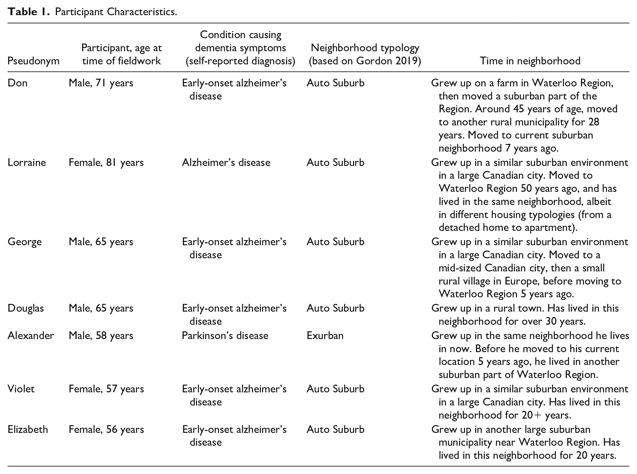
Participants were recruited through community organizations that provide day programming for PLWD residing in community (not congregate care settings), ranged in age from 57 to 81 and all self-identified as living with mild-to-moderate dementia. All participants were comfortable walking outside by themselves and did so in their everyday lives. It should be noted that within the sample, one participant used a mobility device (Elizabeth), and another reported increased fatigue while walking (Lorraine), while the others did not report issues with physical impairments. All participants lived in a neighborhood classified as suburban by Gordon (2019; Table 1). Gatekeepers at the day programs (who knew participants well) provided guidance about consent processes for everyone, and the study used process consent (McKeown et al. 2010).
Participant Characteristics.
During go-along interviews, participant observation was conducted, paying attention to participants’ embodied reactions to the surrounding environment (Hand et al. 2017). During the first go-along interview, participants were instructed to take the researcher on a “tour” of their neighborhood and follow a path they would typically take. The researcher selected the route for the second go-along interview based on the participant’s most frequently traveled route, as identified after 2-week GPS and travel diary tracking. During this interview, participants were asked to identify at least three from each of the following:
Supporting/enabling built environment features (“something that you like, makes you feel safe, comfortable, or helps you find your way”).
Unsupportive/disabling built environment features (“something that you dislike, makes you feel anxious, scared, confused, or uncomfortable”).
When participants identified a barrier or support during the second go-along interview, the researcher took a photo and a video, and the participant narrated the experience. No other people accompanied the researcher and participant during the go-along interview, and the researcher did not correct the participant at any time (e.g., in terms of directions). Participant led go-along interviews and traversed areas they felt comfortable and familiar in, as opposed to unfamiliar settings—an important distinction as these brain processes are different (Gärling, Böök, and Lindberg 2013). Dementia frequently affects areas of the brain related to navigation and memory. Adherence to the study protocol followed guidance on successful research with PLWD—by centering “inclusion, empowerment, expression, flexibility, and communication when selecting methods” (Phillipson and Hammond 2018, 1). Some methods (e.g., using GPS trackers) required extra supports/flexibility to be provided by the researcher and were co-created with participants (e.g., daily telephone reminders); however, at no time were research methods or data generated compromised.
Data analysis followed an integrated approach linking the qualitative go-along interview data with images of the neighborhood taken by the researcher on the walks or gathered using Google Earth. Participant data were geocoded, linking visual images of locations with quotes while in that location (either through researcher-participant captured photos or Google Earth imagery). Each image, combined with explanatory quotations, was treated as independent documents (n = 268) (Cannuscio et al. 2009) for inductive content analysis. The three primary themes emerging from the data were confirmed using peer checking on four of the thirteen go-along interviews (Baxter and Eyles 1997; Brown et al. 2015). After being sorted into the three themes, all 268 documents were further categorized based on:
Embodied and verbalized responses to the built environment (e.g. like, dislike, comfort, discomfort, neutral), related to the subjective (attitudes, perceptions) in Franke et al. (2020) framework;
Social relationship to a particular place (e.g. socio-spatial relationships, memories, daily amenities, turning cue, or not applicable), related to context (social environment) in Franke et al. (2020) framework;
Specific features of the built environment (e.g. green space, street crossing, trail) related to context (built and natural environment) in Franke et al. (2020) framework.
The analysis was facilitated using a qualitative data analysis software Atlas.ti. In terms of the presentation of results, Theme 1 discusses trips to destinations, combining the GPS and Travel Diary data to understand trips and report on descriptive statistics. The rest of the results are drawn from the spatialized analysis for the go-along interview data.
Results
All participants expressed comfort and a sense of emotional security (Lynch 1960) within their neighborhood, produced by their familiarity with navigating these suburban landscapes. They described it as they “just knew” where to go. Violet noted: “. . . especially in my area, because I know this area . . . Because we’ve been here so long that it seems really easy for me.” While some participants had difficulty stating how they knew where to go, their strategies became apparent when the researcher asked why they were turning or asked participants to point out things they thought were important. Another common theme participants discussed were fears associated with being removed from familiar environments and with moving: “. . . if you took me out of the comfort zone, like if we went to the city, well then I could be a little confused” (Alexander). Another participant related his familiar environment to a box he keeps the cobwebs off of:
Like in this little box is that and I keep the cobwebs off that box. So I can look in and see what I need, where I am going, whatever you know . . . And you know I have got everything I need. I have got Canadian Tire . . . and half a dozen other little things places to get things. (Don)
For these participants, it seems the edges of their familiarity form the boundaries of their independent mobility, a common finding in studies on PLWD and their environments: “Where I walk is generally places I know” (Lorraine). The question becomes—what influences the size of that metaphorical box and the limits within which PLWD can be enabled to move by themselves.
Theme 1—Land Use and Transportation Policies
Sixty-seven images and quotations were sorted into this theme, focusing on built environment features more likely to be dealt with in higher-level land use and transportation planning, like segregation of uses and transportation connections. The first subtheme consists of
Next were
I am saying is it easier to know where you are going because you can see really far ahead of you. (Douglas)
However, there were conflicting views on the best kind of street network, as one participant guided the researcher on an approximately 900 m loop, and when asked why said:
Because it goes right down and around. I can go back . . . so this is a kind of loop I do. (Elizabeth; Supplementary Material, Figure B)
One participant overcame proximity barriers associated with typical suburban loop and lollipop design through a pedestrian walkaway between their subdivision and the arterial road on the edge, eliminating the need to find a road exit from the subdivision, which would have resulted in having to walk at least 2 km to reach the same destination (Supplementary Material, Figure C). Related to the street network, participants preferred a
The final subtheme was
Theme 2—Urban Design
A total of 175 images were classified under urban design, which included smaller-scale built environment features that can be regulated through urban design guidelines and zoning by-laws. The subthemes are
The two
I need to get where I am going so I come . . . But it is not my favourite way to walk . . . it is close to so much busy, smelly, traffic. (Lorraine)
This is important because PLWD are more likely to become overwhelmed by noise and activity, restricting their activity space and can cause them to make mistakes while navigating (Brorsson et al. 2013; Mitchell, Burton, and Raman 2004).
Participants frequently associated negative sentiments with
I feel a bit nervous . . . Because I just worry that [cars] are going to, I don’t know, not slow down for me, and so I kind of feel a bit panicky . . . That is a new thing too, panic . . . I get panicky and freaked out. (Elizabeth)
In go-along interviews, all participants crossed a street they deemed unsafe, uncomfortable, or disliked. They attempted to mitigate this discomfort by crossing via protected crossing infrastructure or jaywalking mid-block. Participants preferred to cross at protected pedestrian infrastructure when available and convenient. Suburban arterial intersections considered supportive were those with streetlights with buttons to stop traffic, zebra crosswalks clearly delineated with a crossing guard, stop signs with little traffic, and intersections with fewer cars. Roundabouts were generally avoided, though those with protected pedestrian walking paths across ingress/egress points with a median were perceived as safer.
Two conditions influenced the decision to jaywalk on various street types: distant protected infrastructure and a desire to avoid complex arterial road designs. On arterial roads, participants mostly walked quickly across, and while they said the crossing was fine—the researcher noticed that they had to concentrate and looked uncomfortable before and during the crossing, besides often expressing relief once it was over. Some participants saw a lack of protective infrastructure as forcing them to remain on “their side” of an arterial road, thus limiting their mobility:
But I could probably be a little bit more adventurous as I say, but I don’t like to cross without a streetlight on the big streets, so that is why I am sort of stuck on this side of a [4-lane, 60km/h road]. (Lorraine)
Crossing mid-block without pedestrian infrastructure can be riskier for PLWD because of the depth impairment associated with dementia. The use of medians on arterial roads to avoid the overwhelming sensory experience of protected infrastructure was a coping mechanism:
I will just wait for traffic to clear, and then I will just walk across. Stand in the middle median thing . . . I don’t care then after that . . . because I am halfway and then I can watch the traffic as it comes straight through there like it does. (Alexander)
This is congruent with findings from Brorsson et al. (2013), who found that when using zebra crossings, PLWD were stressed about negotiating cars coming from multiple directions (experiencing cognitive overload).
A central feature of suburban landscapes was
Coming around here . . . it just [makes me feel] nervous. I don’t come. If I can get here, I don’t come [at busy times] . . . it scares me kind of . . . cause you’ve got all sorts of cars coming in for [drive-thru], and it can be really crazy.
Participants expressed distrust of drivers and the need to be “all ears and eyes” (Douglas) and “ . . . to be aware [or] you are liable to be dead . . . ” (Don). Participants described strategically timing their visits to commercial areas with large parking lots to avoid heavy usage. However, participants also highlighted infrastructures within these commercial areas deemed supportive including, accessible parking spots, shaded areas, speed-reducing measures, protected pedestrian pathways through parking lots from spots to stores vis-a-vis painted lines, wide sidewalks with greenery on either side and raised sidewalks in front of stores (
Theme 3—Wayfinding
Eighty-two images of built environment features directly related to navigating the neighborhood and orientating oneself in place were sorted into this theme, further sub-divided into
When participants observed directional
Wayfinding in familiar environments depends on one’s cognitive orienting schema. This section investigates the proprieties of
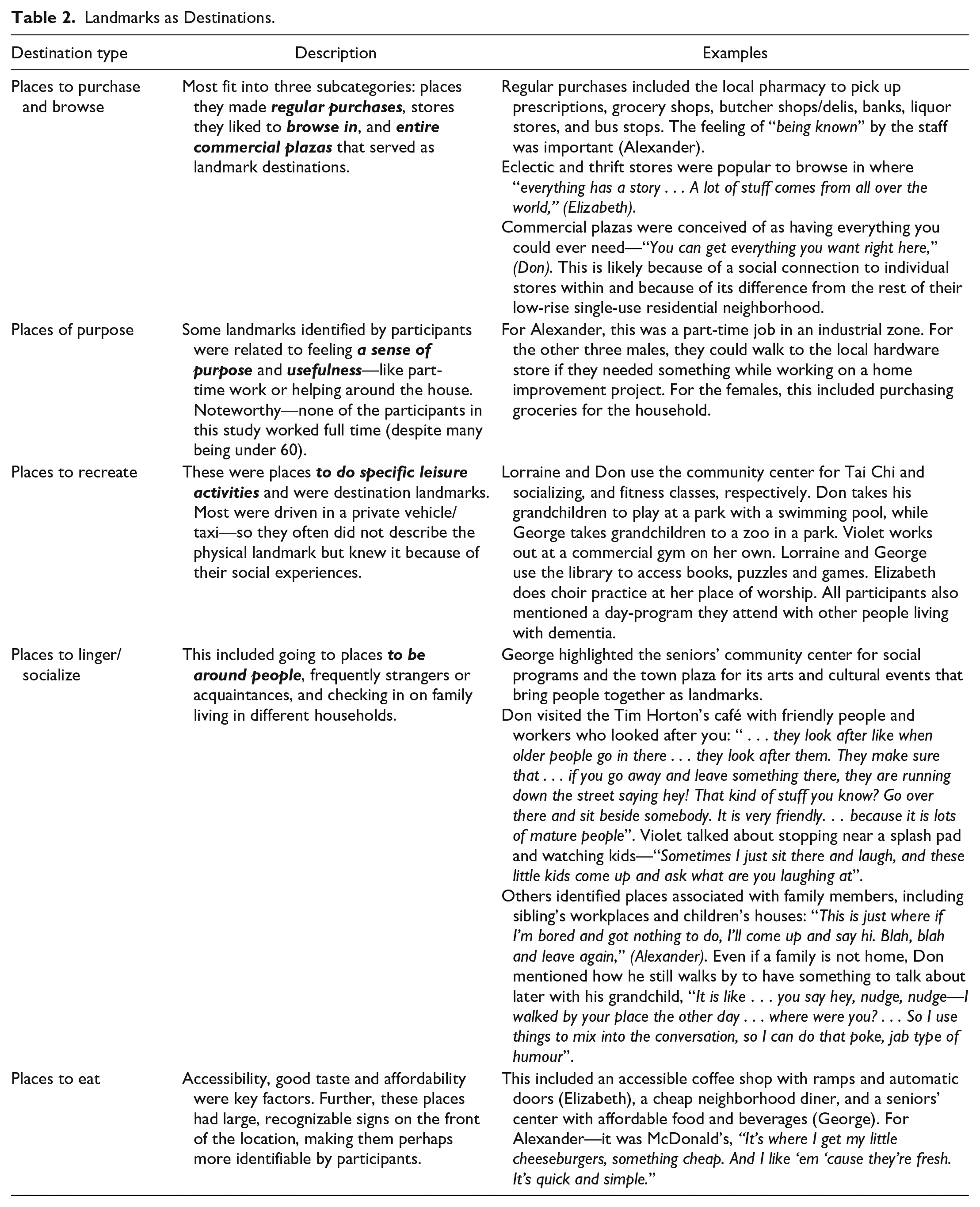
Landmarks as Destinations
Many participants discussed different destinations as landmarks, which seemed to form the anchors of their cognitive map. These destinations were places participants guided the researcher to or discussed during the go-along interviews. They were prominent in participant’s minds, as they had a social connection with each location. The destinations relate to the “proximity to” land-use category. The types of destination landmarks can be found in Table 2.
Landmarks as Destinations.
Landmarks as Compasses
Landmarks that were identifiable from a distance acted as an orientating mechanism by giving participants information about where they were situated within the neighborhood, like the Eiffel Tower operates as a compass in Paris (O’Malley, Innes, and Wiener 2018). For instance, George used the city hall clock tower as a visual compass and as a soundscape landmark because he could hear the chimes every hour from his home. Participants often used landmarks to discern proximity and direction to their destination. Frequently, these distant landmarks were single buildings or built environment features such as a downtown historic building, a pedestrian bridge over a river, high-rise towers, or signage for popular restaurants or natural environmental features like unique home gardens and large rivers. For example, George used a river as an orientating landmark to guide him from his home to the central business area: “You can’t go wrong with a river. They don’t move [giggles] . . . you’ve got compass points built into the landscape . . . wonderful landmark. Terrific!.”
Landmarks as Directions/Beacons
Participants identified neighborhood features that were not destinations but provided information about what to do next (directions) or were recognized on the way to a final destination (beacons) (O’Malley, Innes, and Wiener 2018). They named stores and restaurants that they do not frequent as indicators that they need to change direction. Violet identified places like a restaurant with a big red sign, then a pet store that acted like beacons, showing the way home. Douglas used a small commercial plaza as an indication to turn. Alexander pinpointed a restaurant as his cue to get off the bus (Table 3).
Types of Landmarks Identified by People Living with Dementia.
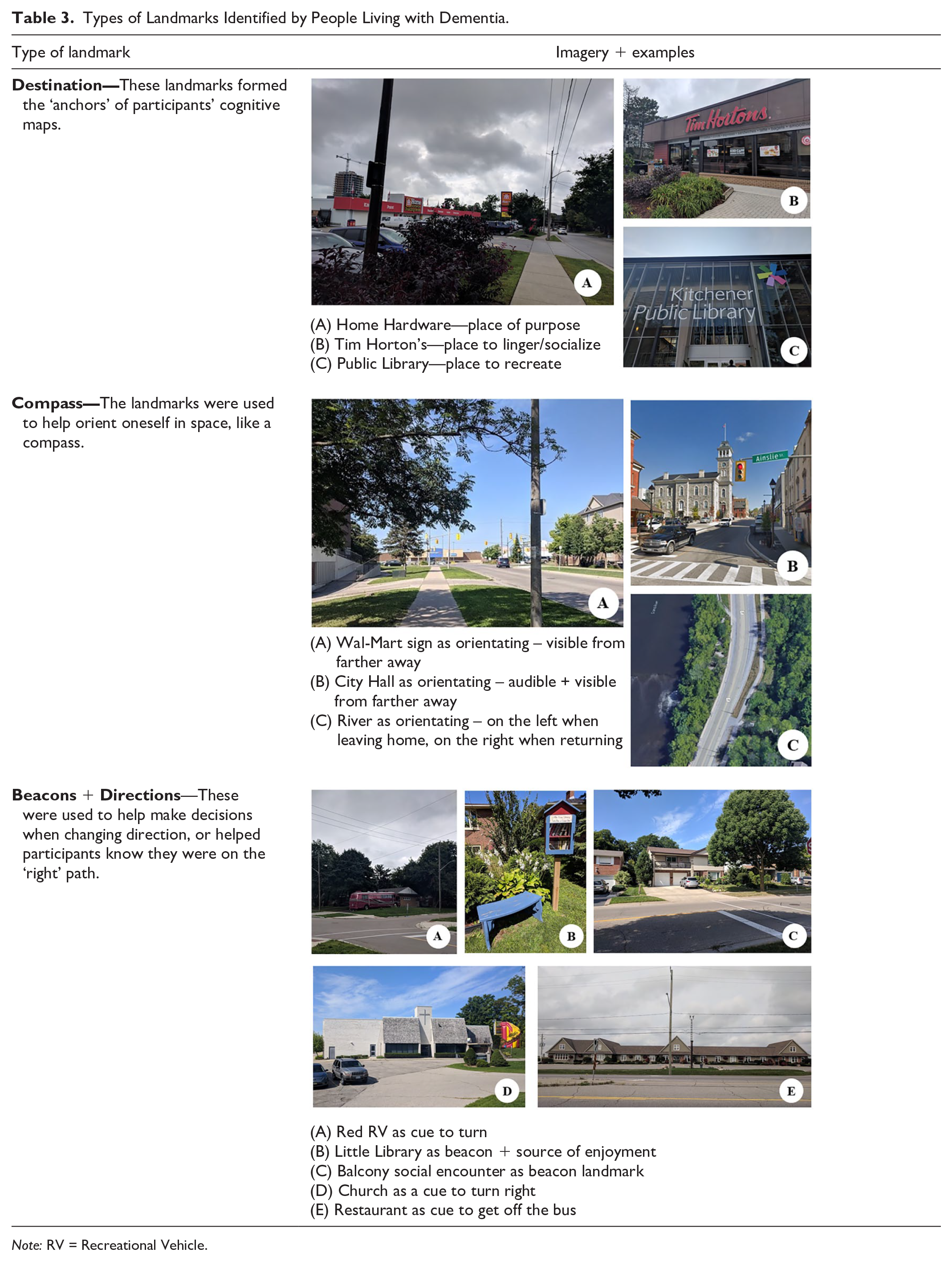
Note: RV = Recreational Vehicle.
Intersections were also used as landmarks helping participants navigate throughout their neighborhood. For example, Douglas used a T-intersection at a church to signify a right turn, while multiple participants navigated to home when in proximity to dead-ends of crosswalks. Furthermore, entrances to trails from streets served as landmarks for participants, directing them to use the trails. Three participants used historical landmarks for wayfinding, specifically a historic district and public art, a cenotaph and an “odd” church.
“Sameness” often characterized participants’ suburban subdivisions, and so PLWD regularly sought out distinct landmarks. Most commonly, landscaping features such as “unique” gardens (e.g., stone and vegetable gardens), a mature rose bush, a decorative chair, a birdhouse, and outdoor ‘little libraries’ 4 were used as landmarks (Table 3). Participants were also guided by unique building or property characteristics, including solar panels on a roof, a red RV in the driveway, a large porch and unique housing façade. For Douglas, the defining feature on one house was a balcony that nearly always had an older couple sitting on it who would wave as he passed (Table 3). When lacking distinct landmarks, Alexander mentioned that he “just kind of keep[s] track” of features as he passes them, such as a pond with ducks that indicates he is on his way to his destination. PLWD used even these mundane characteristics as landmarks for navigation and mobility in their neighborhood.
To bring it all together, Figure E in the Supplementary Material presents an example of how these types of landmarks interact with one another and influence one participant’s go-along interview route. These three themes are intrinsically linked—without the proximity produced by mixed-use nodes in relation to residential zones (land-use), people might have fewer landmarks to situate within their cognitive map (wayfinding) and fewer destinations to access. Furthermore, even with all these elements, if a street crossing is perceived as unsafe, too far away, inconvenient, or prioritizes cars instead of people, PLWD are unlikely to find it as supportive to their mobility (urban design).
Discussion
This research explores mobility for PLWD by assessing and categorizing perceptions of local built environments (Franke et al. 2020) into three themes: land-use and transport, urban design, and wayfinding. In terms of land use and urban design, the findings are consistent with much of the literature on the need for building human-scaled, comfortable, pedestrian environments for vulnerable users like older adults, disabled individuals, and children (Gehl 2010). However, when considering increased risks to crossing or using roads safely for PLWD because of impaired depth perception and judgment and being more easily overwhelmed by noise/activity, these recommendations become imperative to mobility for this group. Regarding the wayfinding category, there is much less literature from an urban planning perspective to create legible built environments for PLWD. This research shows it is important to investigate not only Lynch’s (1960) “public images” (what is most recognizable by a larger group) but also the perspectives of those of marginalized groups, especially PLWD, who experience specific issues related to navigation. Finally, it should be noted that there were no significant divergent findings between the diverse diagnoses of participants (early onset alzheimer’s disease, Alzheimer’s disease or Parkinson’s disease).
Land Use and Transportation Policies
Perhaps unsurprisingly, participants cited the proximity of amenities they had a social connection to, green spaces and trails, as well as a grid network of connected streets as supportive. This is consistent with the literature on the need for mixed-use nodes within neighborhoods for PLWD and research on older adult mobility (Burton and Mitchell 2006; Kerr, Rosenberg, and Frank 2012; Loukaitou-Sideris, Wachs, and Pinski 2019). In many of the participants’ residential suburban neighborhoods, some destinations were accessible on foot, mainly commercial plazas and parks. Conversely, barriers included amenities outside walking distance, slanted/curved streets and dead ends/interrupted street patterns. While participants felt the proximity to destinations trumped comfort, minimizing these adverse overstimulation effects from cars and arterial roads would benefit PLWD. This is also consistent with Mitchell, Burton, and Raman (2004) findings in the UK, which showed increased stress levels in these types of overstimulating situations. While the findings from this study align with those from Burton and Mitchell (2006), divergent findings from this study include participants highlighting the importance of greenspaces like parks and naturalized areas, as well as a preference for using pedestrianized trails instead of roadways. Another unique finding of this research is participants’ rationale for needing the proximity of amenities. Familiar destinations, associated with standard amenities, within walking distance increased participants’ comfort when navigating their neighborhood but contribute to self-imposed mobility limitations. Finally, the citing of single-use residential suburban neighborhoods by all participants as supports (for their quietness, low levels of traffic, safe crossings and familiarity) challenges the idea of suburbs as definitively unsupportive places to grow older for this group of participants (who have lived for many years in their suburban neighborhoods) (Golant 2019).
Urban Design
Residential single-use zones generally follow the “superblock” principles that dominate much of suburban community planning in Ontario (Filion 2018). The by-products of single-use zones are the arterial roads and commercial zones located on the edges, designed for car traffic. Participants had to cross these arterial roads to access destinations, posing several barriers, including unsafe jaywalking practices, discomfort with noise and cars, and unsafe pedestrian crossing infrastructures. Participants employed strategies like walking parallel to busy arterials on a quieter side street or following protected pedestrian trails that ran alongside the road to minimize contact with uncomfortable streetscapes. Besides encouraging traffic calming practices, building wider sidewalks and buffer zones, planners could consider running parallel routes to major traffic-ways. Furthermore, through policy, planners should encourage more medians within street crossing infrastructures, as only having to give attention to one direction of traffic at a time was considered easier for PLWD. Parking lots are another area for improvement. Separated sidewalks, predictable car lanes, and traffic calming measures in these unavoidable features of suburban landscapes can ease the concerns held by some PLWD linked to their symptoms (i.e., sensitivity to noise and sudden movements and impaired depth perception). Creating safer, predictable, quiet landscapes through these simple considerations could improve the ability of PLWD to process their environments and not become overwhelmed and make it more comfortable for all pedestrians.
Wayfinding
This study answers O’Malley, Innes, and Wiener’s (2017) call for more qualitative research on orientation and navigating strategies of PLWD, by revealing wayfinding strategies used by PLWD in familiar spaces. Social connections to the landmarks within their “orienting schema” were integral for PLWD, evidenced by how frequently they arose during the go-along interviews. This could suggest that socially associative places for PLWD are more resilient to resisting dementia symptoms associated with declining navigation skills. It further emphasizes the need to ensure destination elements like green spaces, community centers, places of employment, groceries, hardware stores, and restaurants are within walking distance of residential areas.
Similar to findings from Mitchell, Burton, and Raman (2004), landmarks were often identified at junctions and decision-making situations, suggesting that participants have created these landmarks to situate themselves in these suburban environments of sameness. This research demonstrates participants’ resiliency by creating landmarks with small distinctive features in the landscape. The issue with smaller landmarks like unique gardens and lawn ornaments is that most of these qualities are considered non-permanent. While implementing planning policy to ensure small landmarks on private property could be unreasonable, it is possible to require varied architectural forms for greenfield development and encourage individual homeowners to “be unique.” For heritage policies, stringent urban design/landscape guidelines might be revisited in the hopes of allowing homeowners to create unique features.
The psychological typology of landmarks as serving different functions within one’s “orienting schema” (including as destinations, orienting cues, associative cues and beacons) should be a consideration for planners and policymakers. While one cannot definitively predict what PLWD will select as landmarks, research like this can give us insights into what people might use for different navigational purposes. For instance, planning guidelines could require constructing these kinds of landmarks within the neighborhood, protecting these types of landmarks within viewscapes, or enhancing natural features like rivers and waterfronts to be more visible from elsewhere in the community or city. For instance, protecting views of the CN Tower in Toronto might be a historical view issue and an issue for navigation. When planning for suburban greenfield areas, planners should consider testing designs to make sure they have planned easy, comfortable walking routes to destinations within their development, providing distinct features at intersections, minimizing the number of turns required, putting in a trail system, and using legible signage. Simulated walk-throughs of proposed developments are now accessible through virtual reality technologies, and planners should test routes within developments/plans to ensure adequate landmarks and accessible signage.
This research with PLWD tells us is that connectivity in neighborhoods is not just about the number of parallel streets and intersections—it is about the quality of the neighborhood in terms of useful destinations, comfortable streetscapes and memorable landmarks (orienting, turning cues, and beacons) that help people find their way. It is also important to investigate the different types of landmarks that PLWD use because planners need to think of landmarks beyond Lynch’s (1960) “public images.”
Limitations and Future Research
This in-depth qualitative study was aimed at gathering deep understandings and situated experiences of mobility in one Canadian community. While analytic generalizability is possible (Yin 2013), controlled comparisons are not considered as there was no control group (Patton 2014). Furthermore, this study looked at the experiences of a small, homogenous sample of participants living with dementia (i.e., White, Canadian-born, longtime suburbanites) so the results reflect that specific part of the population. This study was conducted with PLWD who were still comfortable walking alone outdoors and had the physical ability to do so. They had all lost their driver’s license upon diagnosis and were reliant on walking and public transportation to get around independently. Within the sample, two participants also reported physical impairments. Considering that many folks living with dementia might also have physical impairments—future research should pay particular attention to how the lived realities and experiences of multiple impairments impact older adults’ access to the built environment. The study also focused on familiar environments instead of unfamiliar ones (which are understood to be different brain processes), thus representing a particular perspective. Finally, this study only explored experiences in suburban neighborhoods. Thus, while it is possible to say that the participants living with dementia in these environments felt supported in some ways, we cannot say definitively how suburbs perform relative to other settings in terms of supporting PLWD. Future research is necessary to understand the full range of mobility experiences for PLWD, including throughout the progression of the disease. It is also integral to understand how personal histories, socio-demographic factors, changing abilities, sensitivities, cognition, and memory impact mobility experiences in diverse local environments. This research centered exclusively on the perspectives of PLWD as capable conveyers of their life experiences, in response to calls from dementia activists influenced critical disability researchers to move away from using care-partners as proxies (Swaffer 2015). Future research can include a meaningful examination of care-partners’ perspectives of the built environment to understand how the built environment helps/hinders their feelings of support in their caregiving responsibilities and lives overall. Despite these limitations, this study offers several key findings to advance our knowledge and practice for creating supportive environments to enhance mobility for PLWD.
Conclusion
This research describes different PLWD’s reactions to and preferences for built environment features in their familiar neighborhoods. Using Franke et al.’s (2020) mobility framework enabled this research to identify built environment barriers and supports to mobility in terms of land use, urban design, and wayfinding for PLWD in their familiar suburban neighborhoods. The results from this work challenge assumption of the suburban neighborhood as a definitively bad place to grow older (Golant 2019). Participants considered many aspects of their suburban neighborhoods to be supportive of their mobility, and the familiarity of one’s neighborhood proved a powerful support for navigation with PLWD. Participants highlighted coping mechanisms like creating landmarks in monotonous landscapes (e.g. special gardens, noticing parked cars) or avoiding land-use and urban design barriers by choosing to jaywalk or selecting parallel residential streets over arterial ones. However, several barriers within suburban neighborhoods still prevented PLWD from traveling as far as they wanted, like roads limiting movement by not having protected crossings or lacking sidewalks. To use a metaphor from Dementia Alliance International member Peter Mittler, there is a need to build “cognitive ramps” for PLWD (Graham 2017). In their work on how to make universal design more social justice-oriented, Hamraie (2013) argues that building an evidence base would have scholars and practitioners shift from value-based design to designing “with and by misfitting bodies more generally” (23). This paper has done that by working with PLWD and adding to the existing evidence base by identifying socio-spatial barriers and supports to mobility, in the hopes of providing planning academics and practitioners with tangible starting points on how to build more dementia-inclusive communities.
Supplemental Material
sj-pdf-1-jpe-10.1177_0739456X221113796 – Supplemental material for Fostering Mobility for People Living with Dementia in Suburban Neighborhoods Through Land Use, Urban Design and Wayfinding
Supplemental material, sj-pdf-1-jpe-10.1177_0739456X221113796 for Fostering Mobility for People Living with Dementia in Suburban Neighborhoods Through Land Use, Urban Design and Wayfinding by Samantha Biglieri and Jennifer Dean in Journal of Planning Education and Research
Footnotes
Acknowledgements
We would like to sincerely thank everyone who participated in this study, along with their supportive families and partners. This would not be possible without you.
Declaration of Conflicting Interests
The author(s) declared no potential conflicts of interest with respect to the research, authorship, and/or publication of this article.
Funding
The author(s) disclosed receipt of the following financial support for the research, authorship, and/or publication of this article: This work was supported by the Ontario Graduate Scholarship.”
Supplemental Material
Supplemental material for this article is available online.
Notes
Author Biographies
References
Supplementary Material
Please find the following supplemental material available below.
For Open Access articles published under a Creative Commons License, all supplemental material carries the same license as the article it is associated with.
For non-Open Access articles published, all supplemental material carries a non-exclusive license, and permission requests for re-use of supplemental material or any part of supplemental material shall be sent directly to the copyright owner as specified in the copyright notice associated with the article.