
Abstract
The concept of location efficiency is used in academic and gray literature relating to urban form, household location, and associated transportation costs. This paper analyzes the history of this usage of location efficiency and how it evolved into divergent constructs; it then defines three concepts distinguished by scale—household, neighborhood, and municipal location efficiency. These related yet distinct concepts provide clarity use of the term in existing literature and provide a conceptual framework for those looking to employ the concept of location efficiency at every level of research and analysis in academia, applied planning, and municipal policy.
Introduction
Many North American cities have identified a need to shift from the dominant paradigm of auto-oriented greenfield development toward smart growth approaches that emphasize transit-oriented development (TOD), densification, and walkable communities (City of Edmonton 2016; City of Vancouver 2019; Steinbrueck et al. 2014; Trembley 2012). These shifts are promoted as a means of reducing municipal infrastructure and service costs, decreasing greenhouse gas (GHG) emissions and vehicle miles traveled (VMT), and encouraging active transportation. In the context of these goals, the concept of location efficiency (LE) has arisen to consider and measure the interconnection of household location and transportation costs, with reference to particular neighborhood designs and urban forms.
Location efficiency was first identified in research examining the relationship between urban density and gasoline use, which found that higher density neighborhoods within global cities had less gasoline consumption per capita than low-density North American cities (Newman and Kenworthy 1989a). Subsequent studies into the link between VMT and walkability, transit accessibility, and residential density led to the creation of the location efficient mortgage (LEM). The LEM brought household transportation costs into home buying and lending calculations. At this stage, LE became increasingly associated with neighborhood scale attributes that strongly influence transportation, such as residential density, accessibility to services and transit, and walkability.
Over the last three decades, the concept of LE has been used to link home locations to VMT, to validate novel mortgage lending tools, and to describe neighborhood attributes. Although valuable in understanding the costs and benefits of alternative household locations and neighborhood characteristics, the lack of clarity around the term (especially with regards to the scales at which it applies) and the absence of a commonly accepted definition reduces its use. This paper uses a narrative literature review to investigate the creation and evolution of LE as a concept, and to document divergent understandings of LE in contemporary usage. It provides a comprehensive history of the term as associated with neighborhood attributes, household location and transportation costs, as well as a conceptual framework and consolidated definition to guide future use.
This paper begins with a narrative chronological account of the development of LE. Following that, various definitions and usages of LE are analyzed. Third, a comprehensive definition focused on household and neighborhood scales is developed. Through this conceptual and definitional work, this paper positions LE among related planning concepts such as smart growth and TOD. In so doing, it aims to provide clarity for researchers, planners, policymakers, and municipalities as they make use of location efficiency in the future.
Method
This research employs a narrative historical literature review method as described by Onwuegbuzie and Frels (2016) to assess the LE concept in gray and academic literatures. Narrative reviews are helpful in building a comprehensive perspective on a chosen concept or theme, including its development over time (Baumeister and Leary 1997; Ferrari 2015; Green, Johnson, and Adams 2006). This approach facilitates the description of a concept’s evolution through a time period, beginning with its antecedents, first use, emergence, development, and current use (Ferrari 2015; Green, Johnson, and Adams 2006; Onwuegbuzie and Frels 2016). Theoretical discussions and explorations are supported, making narrative reviews an important scholarly tool (Jahan et al. 2016). This method of narrative review allows for a general exploration of a concept by focusing on its evolution and history in foundational sources without performing a comprehensive or systematic review.
Through preliminary research, we identified three categories of academic and gray literature using the terms “Location Efficiency” or “Location Efficient” in their titles, keywords, and/or text. The primary category—and the focus for this study—examined LE in terms of the interconnection of household location and transportation costs (with reference to particular neighborhood designs and urban forms). The evolution of this primary category is examined in the narrative literature review below and further visualized in Figure 2. The second, and by far the largest, category of literature examined various concepts in transportation, urban planning, and housing, and referred to location efficiency in the text, but did not concentrate on the interrelation of transportation costs and household location. This category contained numerous studies on transportation choices and commuting, valuation of real estate, and the siting of other urban infrastructure (like hospitals or ports). This second category reinforces the need for a consolidated definition, as many of these articles employ the terms location efficiency/location efficient in diverse ways, contributing to a lack of clarity in the broader literature. The third category focused on an unrelated topic or discipline entirely. For academic sources, six electronic databases were searched: Academic Search Complete, Science Direct, Scopus, Web of Science, Taylor and Francis Complete, and JSTOR. The academic search captured English-language works published in peer-reviewed journals before May 2018. Searches on Google, Google Scholar, and WorldWideScience.org were used to perform supplemental searches to find gray literature and additional academic sources.
These academic database searches returned 1014 journal articles and gray literature reports, of which 546 were excluded after abstract, keyword, and title review on the basis that they were not applicable to this topic. Examples of non-relevant category 3 results included studies in aquatic biology (e.g. “The functional response of drift-feeding Arctic grayling: the effects of prey density, water velocity, and location efficiency”) (O’Brien, Barfield, and Sigler 2001), while those in category 2 examined, for example, the siting of industrial seaports, the location of new hospitals, and the placement of retail parks (Taket 1989). A further 201 items were excluded as duplicates, leaving 267 for further consideration (see Figure 1). The reference lists of each of the 267 items were then scanned by the first author, and twenty items not previously identified were added. Next, full-text review of 287 items was performed, resulting in 196 being excluded on the basis they were not directly relevant to this research (e.g., category 2 articles that were planning adjacent, but not focused on the interconnection of housing and transportation), with 91 being retained as the data set for this study.
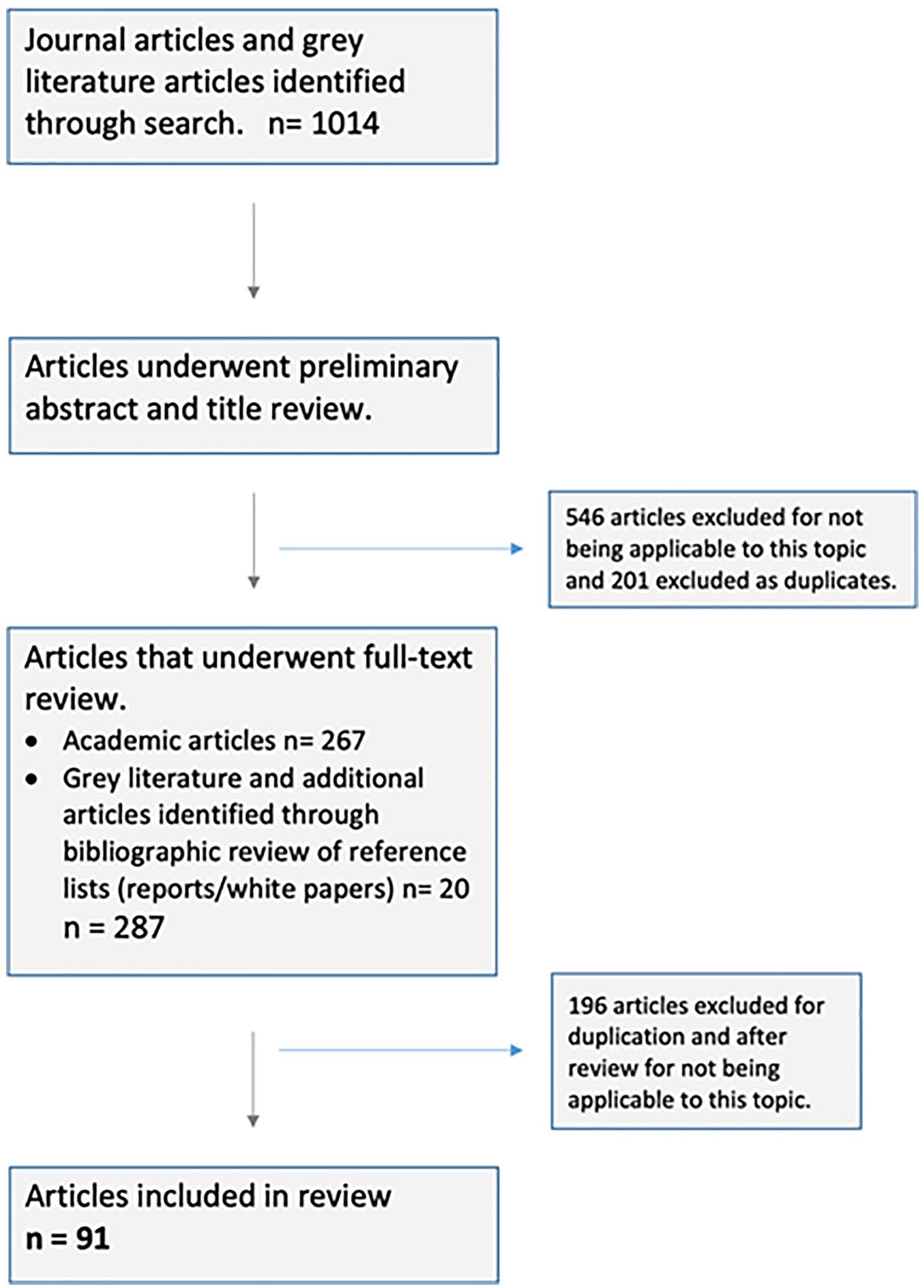
Flowchart of review method.
Results
Early Research
This review highlights the development of the term “location efficiency” with regard to neighborhood attributes, household location, and transportation costs as it has been shaped by researchers, advocacy groups, and government agencies. The concept of LE emerged gradually from research centered on urban transportation, including Pushkarev and Zupan’s (1977) study of the links between public transportation and automobile use. Newman and Kenworthy (1989a, 1989b) made significant early contributions by measuring the relationship between urban form/density and automobile use—initially in Australian cities, and later in major cities worldwide. They found that as metropolitan area densities increased and average VMT decreased (Newman and Kenworthy 1989a, 1989b). In their influential 1989 book “Cities and Automobile Dependence,” Newman and Kenworthy quote Beaumont and Key (1982) to explain the impetus for looking at built form and its implications for energy use: “there has been insufficient examination of what an energy efficient urban form is actually composed of and how such a state can be reached given the present arrangements” (p. 130). Although they did not use the term “location efficiency,” Newman and Kenworthy (1989a, 1989b) documented various factors that became the foundations of the concept—including transit accessibility, commute times, and the “human vitality, intimateness and neighborliness” facilitated by mixed land-uses (Newman and Kenworthy 1989a, 6). Their work also provided a foundation for further studies linking VMT to density/built form, which became a mainstay of research on LE (e.g., Dujardin et al. 2012; Ewing et al. 2016, 2018; Gordon and Richardson 1989; Perumal and Timmons 2017).
In 1991, the Natural Resources Defense Council (NRDC) in the United States supported research into density, neighborhood form, and amenities (Holtzclaw 1991). It found that proximate shopping, walkability, and public transit access were correlated with higher density areas, while lower densities were associated with a lack of local shopping opportunities, reduced walkability, and poor transit connections. This study also reported that residents drove 20–30 percent less on average as density levels doubled (Holtzclaw 1991). This led to further NRDC-sponsored research in 1994 by Holtzclaw and colleagues which attempted to predict VMT and auto ownership for neighborhoods based on walkability, transit accessibility, and residential density. This research looked at twenty-seven neighborhoods across California with varying densities, finding substantial reductions in VMT correlated with transit service coverage and higher density. When residential density was doubled, both VMT and automobile ownership were reduced up to 16 percent, while doubling transit frequency led to an additional VMT reduction of five percent (Holtzclaw 1994; Holtzclaw et al. 2002). Around this same time, Frank and Pivo (1994) found characteristics like population density, employment density, land-use mix, and the balance between jobs and housing in an area were associated with lower automobile usage.
The term “location efficiency” first appears in Holtzclaw (1994), after purportedly being coined by Scott Bernstein, co-founder of the Center for Neighborhood Technology (CNT) based in Chicago (Bernstein and Tholin 2013). The concept of LE has generally been investigated and used within the United States and Canada, with very limited interest and uptake elsewhere. Indeed, only five of ninety-one articles included in this review focus on jurisdictions outside of North America.
Location Efficient Mortgages
Holtzclaw et al.’s 1994 paper also demonstrated the case for the location efficient mortgage. LEMs (also known as transportation credit mortgages) were proposed as a way to curtail urban sprawl by increasing the affordability of housing in denser, more central neighborhoods for moderate and lower income homebuyers. These homebuyers were otherwise often limited to choosing homes in less-expensive and less-location-efficient suburbs (Blackman and Krupnick 2001; Riggs 2016). LEMs were to be applied on a household scale and calculated for each potential home purchase, offering a way for homebuyers to increase their borrowing capacity for more expensive homes in urban and mature suburban neighborhoods. LEMs were based on the premise that homebuyers would have more disposable income for mortgage payments due to lower total transportation costs (including fewer vehicles per household) in these neighborhoods (CNT Location Efficiency Hub 2019a, 2019b; Henry and Goldstein 2010; Poticha and Haas 2006).
In 1994, the NRDC, CNT, and the Surface Transportation Policy Project established a new nonprofit—the Institute for Location Efficiency—to lead further research in this area. It evaluated prospective homes and homebuyers based on an econometric model that incorporated household factors (income, number of members), transit access, center proximity (a measure of neighborhood concentrations of jobs and shopping), neighborhood density and walkability, and automobile expenses based on commuting needs (Siegel 2007). This contributed to the implementation of the LEM as a private market finance tool that allowed mortgage underwriters to assign a location efficiency value (LEV) to potential homebuyers and home choice. Based on the abovementioned criteria, the LEM provided additional credit and/or accepted a smaller down payment to facilitate the purchase of a location efficient home (Siegel 2007). In the United States, the Federal National Mortgage Association (FNMA aka Fannie Mae) provided LEMs through pilot projects starting in 2003 in Seattle, Los Angeles, Chicago, and San Francisco (Bernstein and Tholin 2013; Krizek 2003; Riggs 2016).
LEMs were offered by Fannie Mae until 2006, but despite their potential benefits and calls by homebuyers and academics alike, have not been offered again (Chatman and Voorhoeve 2010). Due to difficulties in calculating the LEV, complications with local land-use, and lending policies, the ease of borrowing before the U.S. housing crash (in 2008), and tighter lending restrictions after the crash, the LEM was officially discontinued in 2008 (Bernstein and Tholin 2013; Blackman and Krupnick 2001; Riggs 2016; Siegel 2007). Fannie Mae also offered a similar product (from 2002) called SmartCommute, which used a simpler calculation for giving households credit for living near public transport and allowed them a small advantage in qualifying for loans. Subsequent research on the effectiveness of LEMs and similar lending mechanisms found reductions in delinquencies/foreclosures and automobile ownership (Blackman and Krupnick 2001; Rauterkus, Thrall, and Hangen 2010; Riggs 2016).
Affordability Indices
The CNT has played a key role in promoting location efficiency through gray literature publications and public advocacy campaigns. It sponsored some of the foundational research on location efficiency by Holtzclaw (1991, 1994) and helped to produce many reports, white papers, and position pieces bringing to light the connections between housing and transportation costs, and the ways in which households can benefit from being aware of this connection. In 2006, CNT and the Brookings Institute attempted to quantify the impact of transportation costs on the affordability of housing choices. Their aim was to provide homebuyers and renters alike with detailed, accessible information regarding the relative costs of choosing a residence in one location compared with another.
To achieve this aim, the CNT analyzed data from the 2006–2010 American Community Survey (ACS), which replaced the long form U.S. census (Hickey et al. 2012), for over nine hundred metropolitan areas. This led to the creation of the Housing and Transportation Affordability Index (H+T®). Hosted on CNT’s Housing and Affordability website, H+T® allows prospective homebuyers and renters in the United States to see the potential costs of their combined housing and transportation in various locations. However, the H+T® has been criticized for using an arbitrary affordability measure (45% of income spent on housing and transportation) and for its exclusion of variables such as household composition (which can affect costs significantly), regional differences in schooling and food costs, and contextual housing preferences (e.g., for larger homes and bigger yards) (Guerra and Kirschen 2016).
Subsequently, the U.S. Department of Housing and Urban Development (HUD) developed the Location Affordability Index (LAI), to build on and operationalize the fundamental precept that household transportation costs are determined by place-based and socioeconomic characteristics (Ganning 2017; Poticha and Haas 2006). The use of this index in lieu of conventional measures of housing affordability illustrated that when transportation expenses are incorporated in calculations, auto-dependent urban areas are often considerably less affordable than they first appear. The LAI estimates housing and transportation costs for eight household types, and as Ganning (2017, 809) points out, users must choose from these types and “cannot change any of the selected type’s defining characteristics, which are various combinations of income level, household size, and number of commuters.” Ganning’s analysis also identifies problems with data reliability and validity, such as the overestimation of costs in metropolitan areas.
In 2012, the Environmental Protection Agency’s (EPA) Smart Growth Program developed its Smart Location Database to “compare the location efficiency of various places” (Ramsey and Bell 2014). This database can be used by researchers and practitioners in four ways: to assess and compare neighborhood conditions; to conduct nationwide research studies and develop associated tools; to compare urban form among metropolitan regions; and to model impervious surface growth. The Smart Location Database incorporates more than ninety diverse indicators associated with the built environment and LE. These indicators include density of development, diversity of land-use, street network design, and accessibility to frequent destinations, as well as various demographic and employment statistics (https://www.epa.gov/smartgrowth/smart-location-mapping).
Another location evaluation tool developed at this time was HUD’s Low Transportation Cost Index. It uses the LAI to estimate transportation expenses at the neighborhood (census tract) level for a low-income, single-parent renter family. Values are presented as percentiles (0–100), with higher values representing lower transportation cost neighborhoods for this household type (HUD 2017).
Location Affordability
In North American cities that continue to grow outwards, the majority of new development takes conventional suburban forms. However, most understandings of the affordability of new suburban development consider only housing costs in relation to income. Homebuyers’ perceptions that more affordable housing is available in newly developed suburbs (captured by the colloquial expression “drive ‘til you qualify”) can lead to excessive transportation costs, which are not accounted for in the home buying equation. Since the early 1990s, there has been a growing recognition that housing costs are closely related to household transportation costs and that these should be combined to represent comprehensive housing costs more realistically. Tremoulet, Dann, and Adkins (2016) identify a reconceptualization of housing affordability research towards a “combined cost of place” approach that incorporates the transportation costs that are associated with choosing a home in a particular location as well as typical housing costs like mortgage payments or rent, and maintenance (see also Adkins, Sanderford, and Pivo 2017; Hickey et al. 2012). The “residual income approach” to housing affordability, which focuses on household financial resources leftover after paying for basic expenses, has also been modified to include transportation costs (Coulombel 2018; Fisher and Brown 2009; Renne and Sturtevant 2016).
The concept of location affordability enables a comprehensive view of the expenses associated with different home locations. In particular, it highlights the transportation costs associated with homes in location inefficient areas, which often necessitate long car-based commutes, as well as the cost savings that may accrue to households from more location efficient choices. CNT’s H+T® index report suggests that households should spend no more than 45 percent of their household income on housing and transport expenses (up to 30% for housing and up to 15% for transportation) (Poticha and Haas 2006). Location affordability encompasses the combined housing and transportation costs that a household can theoretically support. This said, there is sometimes slippage in the literature, with location affordability and location efficiency being presented as synonyms (e.g. Renne et al. 2016).
Location Efficient Neighborhoods
Although LE was initially applied to households, including through mechanisms such as the LEM, the more prevalent use of the term now focuses on neighborhood level attributes. Neighborhoods are considered location efficient when they provide residents with convenient access to desirable services (healthcare, cafés, banking, restaurants), jobs, shopping, schools, and transportation options that provide cost-effective, easy-to-use alternatives to private vehicles (Poticha and Haas 2006). From this perspective, the “efficiency” of a location is understood primarily in terms of the opportunity for reduced reliance on private vehicle travel for frequent trips (which may be realized in terms of fewer VMTs): Simply put, location efficiency converts driving from a necessity into an option. Location efficiency requires neighborhoods that provide high-quality transit, a mix of uses, and pedestrian-friendly design. Proximity to transit is just one of several key variables that determine the location efficiency of a neighborhood. Other critical factors include net residential density, transit frequency and quality, access to community amenities, and a good quality pedestrian environment (good sidewalks, safety, reasonable topography) (Belzer and Autler 2002, 1).
From around 1995, a divergence in the LE literature appears, with one stream of research and policy advocacy focused on the household scale (and in particular the LEM) and another stream focused on neighborhood characteristics. Prior to this point, consideration of neighborhood level factors had often been secondary to, and largely subsumed within, discussions of household automobile usage. Neighborhood-oriented research also supported a return to the foundations of the LE concept, with inquiries into the relationship between neighborhood attributes and levels of auto-ownership and VMT. For example, Our location efficiency study explores the hypothesis that the average household auto ownership and driving decrease measurably as likely trip destinations become more convenient, especially by non-automotive modes. Further, it tests the assumptions that residential density, center proximity, local shopping, public transit accessibility and the pedestrian and bicycle friendliness of the neighborhood are good measures of that convenience (Holtzclaw et al. 2002, 7).
This notion that some neighborhoods are more location efficient than others due to the sorts of factors listed in the two preceding quotes has become the dominant perspective on LE, particularly in gray literature and urban planning vernacular (Burda 2012, 2014; Poticha and Haas 2006). Understandings of LE centered on neighborhood amenities (and household proximity to these amenities) consistently identify five core components: accessible employment; compact mixed-use development (density); accessibility of transit; active transportation and walkability options; and proximity and convenience to amenities and services (Belzer and Autler 2002; Burda 2012; Poticha and Haas 2006; Rose 2011).
Connections to Smart Growth and Transit-Oriented Development
To clarify LE and its place in larger literatures around urban planning, transportation, and housing, discussion on the closely associated terms of Smart Growth and TOD is warranted. Smart Growth is a response to the negative ecological and social consequences of suburban sprawl, which it seeks to counter by redirecting development inward, toward existing communities and by enhancing transportation, employment, and housing choices within urban regions (American Planning Association 2012; Burchell, Listokin, and Galley 2000). Many of the key principles of Smart Growth overlap with the concept of location efficient neighborhoods, including mixed land-uses, diverse housing choices, walkability, varied transportation options, and promoting sense of place (http://smartgrowth.org/what-is-smart-growth/).
Smart Growth concentrates on redirecting development toward inner areas of a city which are typically more efficient than outer suburbs. Furthermore, in so doing, it increases the “D-variables” within these inner areas: “development density, land use diversity, walkable/bikable design, destination accessibility, and distance to transit” (Ewing et al. 2016, 168). Smart Growth’s focus on expanding housing options potentially increases the supply of LE housing and may reduce the higher costs often associated with this option, which can be a barrier to homebuyers (hence the creation of the LEM).
Whereas Smart Growth principles are often applied across municipalities and urban regions, TOD is more focused on smaller scale interventions that make housing and amenities available within an accessible range (by walking and cycling) of public transit options (Dittmar and Poticha 2004). This is normally accomplished by developing moderate to high-density mixed-use communities around transit nodes. These developments are specifically intended to promote LE and reduce VMT. Indeed, Dittmar and Poticha (2004) identify LE as being one of the five main goals of TOD, alongside a rich mix of housing choices, value recapture, place making, and resolution of the tension between node and place. Policy initiatives like the LEM could complement TOD, making mortgages more accessible to potential homebuyers in settings well served by transit. Research has shown that choosing to reside in a compact transit-accessible neighborhood can help cut household transportation-related costs, freeing up income for housing purchases or servicing a larger mortgage (Cervero 2007).
Toward a Consolidated and Clear Definition
The term “location efficiency” has come to be used in a dichotomous way, to describe either a set of neighborhood-level attributes generally associated with “good urbanism,” or a household-level metric encompassing housing and transportation costs (Figure 2). This creates considerable potential for confusion, with research and initiatives typically adopting one understanding of the term without acknowledging alternative approaches or any particular scale of application. Integrating and applying scale within the definition of location efficiency assists in keeping track of this distinction, and in understanding how and why both household and neighborhood factors are relevant to understanding LE. Additionally, attentiveness to scale can link diverse applications of the LE concept, not only in terms of household locational decisions and the design and planning of neighborhoods but also in terms of potential extensions to the municipal and regional scales.
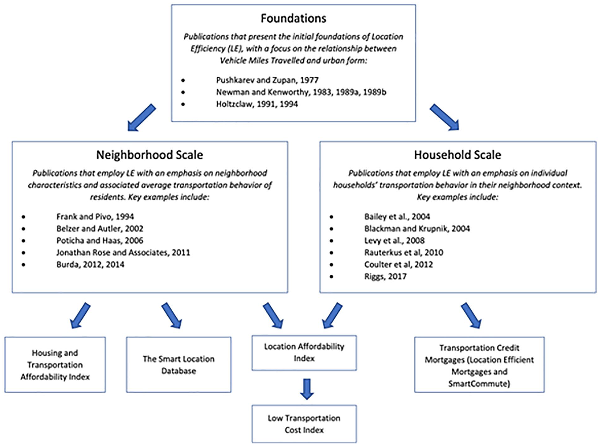
Foundations and divergence of location efficiency.
In academic contexts, scales can be understood as “qualitatively distinct levels for organizing and conducting research” (Sayre and Di Vittorio 2009, 22). While distinct, scales are not separate, and scales are best understood in relation to each other. Indeed, as Marston (2000, 227) has stated, “scales are not unilinearly ordered—with the global theoretically and empirically superior to the local—but rather they interpenetrate.”
Household Location Efficiency
At the household scale, the core component of LE consists of the costs related to daily transportation needs within the neighborhood, city, and region. While most studies have employed aggregate measures to explore these costs, it is understood that each household (made up of individuals) will have its own unique transportation-related costs. In the first instance, these are financial costs, although time costs, GHG emissions, and related health and wellness costs can also be considered. When a household experiences lower transportation costs as a function of their home location, they can be considered (more) location efficient. Location affordability is also part of LE at this scale and pertains to each household’s income levels and housing costs. At this micro scale, we propose using the term “household location efficiency,” which we define as, The location related costs and benefits of transportation for households as determined by members’ unique context with regards to their household transportation needs, preferred mode of travel and specific home location.
In essence, household location efficiency is associated with the combined financial situations, transportation needs, and preferred transportation modes of the whole household. As one individual member’s LE might differ from another’s based on work location, frequent destinations, and preferred modes, these factors must be compromised or negotiated when choosing a home location as a household (Bailey, Blake, and Cooke 2004; Coulter, van Ham, and Feijten 2012; Ferreira and Taylor 2008). Research on families and home buying has found that in addition to the adult members of the family, decisions are strongly influenced by “social collectives” made up of the children as well as friends and extended family members (Levy, Murphy, and Lee 2008).
Neighborhood Location Efficiency
Recent LE literature emphasizes the ways in which neighborhoods themselves are important contexts for everyday life and related decision-making. The relationship between neighborhood and household level factors (home location; travel behavior) is more complex than it may first appear, due to the possible confounding nature of residential self-selection on travel behavior (Bohte, Maat, and van Wee 2009; Cao, Mokhtarian, and Handy 2009). Specifically, households may select home locations according to their existing travel preferences (e.g., those who prefer to walk will choose more walkable neighborhoods, and those who want to drive will choose commuter neighborhoods). However, research by Ewing et al. (2016) has shown that the neighborhood has an independent effect on travel behavior, based on location (within the city, along transit corridors, on the city’s edge) and design (via characteristics like density, walkability, accessibility). At this meso scale, we propose using the term “neighborhood location efficiency,” which we define as, The opportunities for reduced transport costs offered by compact mixed-use neighborhoods with accessible employment opportunities, shopping and essential services, and convenient access to public and active transportation options (e.g., trails, infrastructure for walkability, cycling infrastructure).
Neighborhoods are also made up of households with varying levels of LE. The interrelatedness of household and neighborhood LE recognizes the bi-directional nature of these scales. Of note here is that the concept of Neighborhood Location Efficiency is also related to aggregate measures of behavior. It is entirely possible that some residents in a highly location efficient neighborhood possessing all of the attributes outlined above could have low individual or household location efficiency due to their own context and transportation habits.
Municipal Location Efficiency
Although household and neighborhood scale LE are the focus of this analysis, there is merit in discussing LE at municipal and regional scales, particularly in terms of planning and policy implications. Attentiveness to LE at these scales may reveal, for example, policy disparities between nearby municipalities that allow sprawl to occur within the region of which they are part. Figure 3 illustrates the interrelatedness of neighborhoods within municipalities, and of municipalities with regions, and acknowledges the potential impacts of higher orders of government on all of these scales. Interactions between scales are significant with regard to residents choosing home locations, for example, when municipal and regional policies (potentially including Smart Growth and TOD) combine to shape the availability and form of housing within neighborhoods, the accessibility of transit and active transportation options to residents, and proximity to centers of employment and services.
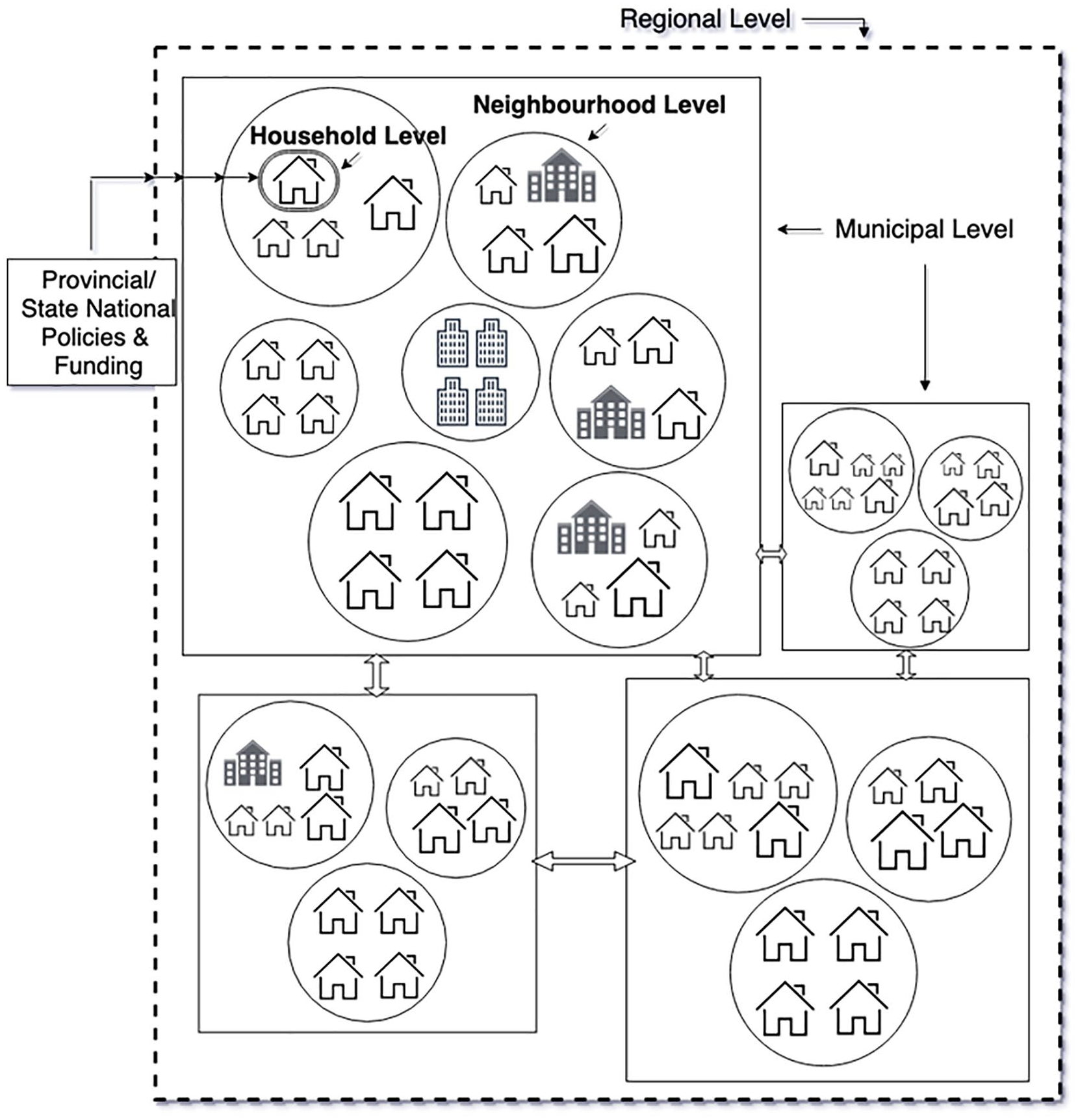
Location efficiency and scale.
Similar to a location efficient neighborhood, a location efficient municipality would provide accessible services, amenities, housing, employment, and transit and active transportation options. However, an additional concern emerges at this scale—namely, the equitability of service/amenity provision across the municipality (e.g., whether the transit system provides adequate levels of coverage and accessibility to all areas of the city, given varying levels of need). Concerns for equity and accessibility may reveal different levels of LE across neighborhoods (i.e., in terms of their provision of LE attributes), which may reflect variable levels of funding, and infrastructure and service provision. At this macro scale, we propose using the term “municipal location efficiency,” which we define as, The extent to which a city provides accessible services, amenities, employment, and transit and active transportation options equitably to all residents across all neighborhoods.
Policies that municipalities may employ to increase LE include prioritizing TOD to increase the accessibility of services, employment, and transit, especially in neighborhoods where this accessibility is currently low. Federal and provincial/state housing and transit infrastructure funding (where available) could also be used in ways that prioritize achieving higher levels of municipal location efficiency. This work could be informed by initiatives such as the H+T® index and the EPA’s Smart Location Database. Guidance could also be provided by regional authorities, where these exist, to municipalities to stem the loss of agricultural or natural lands to exurban low-density growth (potentially via regional growth boundaries, such as Metro Vancouver’s Urban Containment Boundary) and regional transit systems (e.g. Metro Vancouver’s Translink) that move commuters from bedroom communities to employment centers in other municipalities more efficiently (Metro Vancouver Regional Growth Strategy Bylaw 2040 2017). Regional considerations should be investigated further in future research.
Conclusion
Our narrative literature review identified and described the origins and evolution of LE, from initial studies into the association between VMTs and density in urban areas, to a focus on the housing and transport costs borne by households in varying locations, to gray literature focusing on neighborhood level amenities that may reduce car dependence and promote transit use and active transportation. We found a co-existence of household and neighborhood level understandings of LE, which has not previously been identified, contributing to slippage and some confusion in use of the term. Our direct application of scale is intended to highlight these two distinct uses as well as provide a foundation for exploring their interconnection. Attentiveness to scale also enables applications of LE at other levels to be identified and explored, as we highlight with reference to municipal LE. We further proposed straightforward definitions of household, neighborhood, and municipal LE, with a view to improving understanding and encouraging consistent use of the concept.
Greater clarity should contribute to further uptake and application of LE amongst both academics and practitioners interested in the neighborhood/transportation/housing nexus—a common focal point and object of inquiry in planning and urban studies more generally, including outside of North America (the focus of most LE literature to date). For academics, we see this paper as providing a foundation for LE to be more effectively integrated into theory and used in research. This contribution is based on our identification of foundational texts, our multi-scalar response to the longstanding call for “examination of what an energy efficient urban form is actually composed of” (Beaumont & Key 1982, p.130), and our clarification of connections with the related planning concepts of Smart Growth and TOD (which themselves tend to operate at different scales). For practitioners, we believe this paper will reduce the likelihood of misunderstanding in communications related to LE (in gray literature, meetings, policy settings, and so on). Of critical importance here is our identification of the ways in which the scale at which LE is being discussed or applied will necessarily direct planners’ focus to different transportation costs—whether those incurred by households (alongside their housing costs), those associated with different neighborhood forms, or those linked to the equitability of municipal decision-making and service provision. Furthermore, this paper could be used to support more widespread development of housing and transportation cost tools that can inform household decision-making (and potentially home financing).
A suggested next step in continuing this research would be the creation of a metric to be employed in comparing the relative location efficiency of different neighborhoods. This metric would require the use of an appropriate delineation (e.g., census tract or postal code) to directly compare small areas in different geographical locations. With further development, it could be used to compare municipalities and regions, the scales at which critical policy decisions relating to transit, land-use, density, and so on are often made. Ultimately, this multi-scalar location efficiency metric could be used as the foundation for a tool that would allow households, academics, and planners to compare housing and transportation costs across neighborhoods, municipalities, and regions, and would also facilitate location efficiency policy implementation.
Location efficiency has developed over the last three decades as a valuable concept focusing attention on the costs of living associated with different locations in cities. Lower GHG emissions, lower infrastructure costs to municipalities, higher rates of active transportation, and improved quality of life have all been identified as benefits of location efficient home choice. The related concept of location affordability (based on combined housing and transportation costs) has also gained prominence and provides an important perspective on the true costs associated with living in highly automobile dependent locations. Incorporating scale into the LE concept helps to highlight its relevance at all levels of planning and policy making, and may provide a foundation for advocacy and further development of tools by governments and non-profit organizations.
Footnotes
Acknowledgements
The authors thank the reviewers for their insights and suggestions which have helped strengthen this paper. The authors also thank the researchers and practitioners who forged a path before us in this area of study.
Declaration of Conflicting Interests
The author(s) declared no potential conflicts of interest with respect to the research, authorship, and/or publication of this article.
Funding
The author(s) received no financial support for the research, authorship, and/or publication of this article.