
Abstract
How are urban population and its growth distributed across urban settlements of different sizes? In the Global South, this is a critical planning question, yet its answer is muddled by contradictory claims in the literature and inconsistent data. Using a new dataset measuring urbanization from 1975 to 2015, we find that urban populations in the South are less concentrated in megacities than in the North—contrary to conventional wisdom. Given an explosion in the number (not simply size) of urban settlements in the South, we suggest reviving the concept of “barefoot planning” as an approach for empowering communities beyond the metropolis to shape the urbanization process.
Introduction
The trope associated with the “developing world” was once a rural village, stuck in an unchanging, “pre-modern” past. More recently, this trope has been replaced with another: vast, sprawling megacities teeming with tens of millions of people, most concentrated in slums (Davis 2007). Popular media give the impression that the urbanization unfolding across the Global South is heavily concentrated in the largest urban agglomerations, and that the future is not only urban but indeed defined by the megacity (German and Pyne 2010; Ward 2018). For urban planning, this would suggest that the biggest challenge to be confronted in the twenty-first century revolves around planning and governing a limited number of very large cities.
This article asks a set of empirical questions to test these assumptions: How are urban populations distributed within countries in the Global South, and how is this distribution changing? Are urban populations concentrated, or concentrating, in the largest metropolitan areas in rapidly urbanizing countries? We then consider what these trends mean for planning in the twenty-first-century Global South.
For planning, both practical and epistemological concerns motivate the question of where urbanization is occurring. Planning must examine whether the resources and capacities to shape urbanization are being developed in places experiencing the fastest growth. The structure of urban systems may also influence what planning approaches are most relevant in a given country context. Demography also drives research agendas more generally. For example, scholars have often framed their calls for a “Southern turn” (Rao 2006) in urban studies by citing the demographic fact that most urbanization is now occurring in countries of the South (Parnell and Oldfield 2014).
Yet the literature offers competing claims on the straightforward empirical questions of how urban populations are distributed in the Global South, and how those distributions are changing over time. One reason for the lack of consensus is that, until recently, there existed no harmonized time-series data measuring the population of urban areas, including the smallest urban settlements, over time using consistent definitions. In our analysis, we use a new data source that fills this gap, the Global Human Settlements (GHS) database (Florczyk et al. 2019a), which planning scholars have not yet extensively used. As we discuss, the GHS is a significant improvement on United Nations (UN) statistics on urban areas, the most commonly used data for analyzing urbanization patterns across countries.
Our analysis of GHS data underscores a phenomenon crucial to planning in the Global South: the proliferation of new, spatially independent urban areas. While the number of megacities—agglomerations of more than ten million—grew by seventeen between 1975 and 2015 across low-, lower-middle- and upper-middle- income countries (applying World Bank definitions), the number of cities of 50,000 to 300,000 people in the same countries grew by 3,153. Over the same period, growth in the population in these countries living in towns—small, medium-density urban settlements where some planning functions are necessary—was greater than the combined population growth of their megacities.
We also find that, in contrast with claims frequently made in the literature, urban populations are not more concentrated in megacities in the South as compared with the North. The fact that the Global South hosts most of the planet’s largest cities is a reflection of overall population more than urban population distribution. In fact, towns and small and medium-sized cities are a particularly important part of the urban landscape in low- and lower-middle-income countries.
Our findings suggest that planning’s biggest twenty-first-century challenge revolves around shaping urban growth in a large number of small places, as opposed to a small number of large places. As our literature review illustrates, smaller cities in the Global South are among the most resource-constrained urban areas in the world when it comes to planning capacities. In the argument that follows, we call for creative strategies to ensure that core principles of planning, such as inclusion and sustainability, find advocates in the thousands of emerging cities that lie beyond metropolitan areas and megacities. Specifically, we propose a revival of the concept of “barefoot planning” (Dix 1980; Oberlander 1987)—an approach that would provide training in basic planning-related skills to a cohort of citizens in small towns and cities, empowering them to perform some roles traditionally reserved for professional planners.
This article is organized as follows. First, our literature review examines competing claims surrounding the distribution of urban growth in the South and explains how data constraints have limited our understanding of the importance of towns and small cities. We also consider what urban scholars know of small cities in the South and their specific planning contexts. After describing the data, we present the results of our analysis of urban population distributions across countries and regions, which highlight the persistence and proliferation of towns and small cities. Finally, we consider planners’ role in shaping urbanization in these geographies, and describe why the framework of barefoot planning balances the need for coordinated and grassroots approaches to planning in emerging urban environments.
Literature Review
This paper addresses two issues of importance to planning scholars and practitioners: the distribution of urban growth in the Global South, in particular the demographic weight of towns and small cities; and the planning implications of a dramatic expansion in number of urban settlements at the bottom of the urban hierarchy. In this section, we review literature relevant to each of these themes.
Small Cities in Urban Systems of the South: Competing Claims and Methodological Constraints
In the mid-twentieth century, as many Global South countries became independent from colonial powers, development scholars grew concerned about “primate” cities that held dominant economic and political positions within their respective countries (Berry 1961). These scholars argued that underdevelopment led to urban systems that transgressed Zipf’s Law (Zipf 1941), that is, rank-size urban hierarchies with log-normal distributions. While the causal and normative claims of this literature have been called into question (Sovani 1964), the notion that urban systems in the South are “top-heavy”—with urban populations highly concentrated in the biggest cities—has proven durable (Sheppard 2014). Henderson (2002, 89) writes, “The rapid urbanization in many developing countries over the past half century seems to have been accompanied by excessively high levels of concentration of the urban population in very large cities.”
However, these claims contrast with others who argue that, if anything, countries in the Global South do not have large enough cities. In some countries, scholars find that rank-size regularities would predict bigger cities at the top of the urban hierarchy (Chauvin et al. 2017), and in other contexts, scholars argue more normatively that the economic benefits of urbanization require bigger cities (Naude and Krugell 2003; World Bank 2009). On the question of where growth is occurring most swiftly, we observe similar contradictions. Hall and Pain (2006, 9) argue that the entire urban hierarchy has “shifted upwards” in favor of megacity regions and Castells (2010, 2739) claims that the metropolitan region is now a “universal urban form.” However, other scholars of urban growth, such as Angel (2012, 117), find that “we should not expect larger cities to grow any faster than smaller ones”—a restatement of Gibrat’s Law (Gibrat 1931)—and argue that megacities “should not command our undivided attention.”
Data constraints are one factor underlying these contradictions. In particular, scholars have lacked a clear understanding of how much of the world’s population lives in small urban settlements, as these geographies often lie on the cusp of rural–urban binaries and fall outside the bounds of inquiry for urban scholars. UN data, which are widely used in analyses of urbanization, have been critiqued for using a collection of unharmonized, national definitions of urban (Roberts et al. 2017). There is another issue, however, with these data: given that they lack disaggregated data for urban areas of less than 300,000 people, they offer little clarity on how populations are distributed at the bottom end of the urban hierarchy. Similarly, Angel et al. (2016) create a global sample of cities, intended to represent the “universe of cities,” but only include those with at least 100,000 people. In addition, methodological issues sometimes result in an underestimate of small cities’ role in urban systems. For example, owing to limitations with settlement-level data, Chauvin et al. (2017) treat the urban population of each district in India as a single city. This effectively collapses together functionally and spatially distinct small urban settlements in most of the country’s districts, thereby artificially inflating the average city size. As we discuss below, the GHS data we use in this paper address many of these data and methodological constraints.
Understanding and Planning the Non-metropolitan Urban South
What do we know about urban places beyond the metropolis, especially in the Global South? In general, scholars argue that small cities are neglected in urban studies, limiting our understanding of their specificities (Garrett-Petts 2005; Ofori-Amoah 2007). Bell and Jayne (2009), for example, argue that world city theories (Friedmann 1986; Sassen 1991) have relegated smaller places to a marginal position in urban studies. Zérah and Denis (2017) and Cook (2018) note that despite growth in urban scholarship from the Global South, small cities have received relatively scarce treatment in this literature as well.
Despite their relative neglect in urban studies, multiple strands of literature offer useful entry points into understanding towns and small cities of the South and their planning contexts. The oldest of these threads, which originated in the 1980s, emphasizes the critical role of towns and small cities in the Global South in alleviating poverty by linking rural and urban economies and promoting the symbiotic development of both (Hardoy and Satterthwaite 1986; Rondinelli 1983, 1988). These arguments continue to echo throughout the development studies and development economics literatures (Christiaensen and Todo 2013; Gibson et al. 2017; Satterthwaite and Tacoli 2003).
While small cities of the South may have potential to act as centers of economic development, planning scholars have argued that they also face specific obstacles to inclusive urbanization. In general, scholars warn of small cities’ susceptibility to elite capture (De Neve and Donner 2006; K. L. Sharma 2003). Kudva (2015) finds higher levels of income inequality in small cities as compared with large cities in India, and both Kudva (2015) and Singh (2006) find that institutions of constructed difference—caste, gender, and religion—are especially powerful influences on small Indian cities. In South Africa, Giraut and Maharaj (2002) find the drawing of municipal boundaries of small and secondary cities to be heavily influenced by the legacies of racial apartheid. These conditions necessitate a progressive role for planning in small cities.
As scholars have highlighted, however, smaller cities in much of the South have scant resources and planning capacities. In a study of Morocco, Kenya, and Vietnam, Tuts (1998) finds that human resource constraints—especially with regard to urban planning—inhibit the ability of municipal governments in small cities to implement sustainability initiatives. In his work on towns and small cities in West Bengal, Rumbach (2016) finds that disaster management institutions, knowledge, and capacity are lacking—even following decentralization reforms intended to empower local governments. Zérah and Denis (2017) argue that urban local bodies in small Indian cities are alienated from decisions around land use by top-down regional megaprojects.
Despite these constraints in the formal planning apparatus, small cities in the South are not “unplanned.” Citizen groups often step in to close infrastructure and governance gaps. For example, Bryceson’s (2011) study of Katoro, a market town in Tanzania, reveals how private, informal electricity networks have expanded service provision and spurred small-scale industries. In towns of north India, K. Sharma (2012) finds that neighborhood committees have been successful, albeit at a small scale, in organizing street sanitation and transforming vacant lots into community gardens. Pasquini (2020), in her study of Karonga, Malawi, suggests that the dense local networks of civil society that characterize smaller cities enable innovative strategies for climate change governance, in contrast to larger African cities where climate change governance is influenced more by global knowledge networks. These examples signal the potential of harnessing community-based initiatives in efforts to improve the planning capacity of small cities in the South.
Data and Definitions
Our empirical analysis of the distribution of urban populations in the Global South uses the European Commission’s GHS database, which employs the “Degree of Urbanisation” approach to identifying and classifying human settlements in a consistent manner across the world. The GHS applies criteria based on population size, population density, and built-up proportion to classify one-square-kilometer grid cells on a global map as belonging to various kinds of settlements. To gather these granular data, GHS researchers use a combination of data on built-up areas derived from satellite images (from the years 1975, 1990, 2000, and 2015) and population data from national censuses (Florczyk et al. 2019a; Pesaresi et al. 2016). 1 The classifications that they use, outlined below, do not depend on any administrative boundaries or administrative definitions of “urban” applied by governments.
Urban center: a cluster of contiguous grid cells in which each cell has a density of at least 1,500 inhabitants/km2 or is at least 50 percent built-up, which hosts a total cluster population of 50,000 inhabitants or more;
Town: a cluster of contiguous grid cells in which each cell has a density of at least 300 inhabitants/km2, which hosts a total cluster population of between 5,000 and 50,000, and is not adjacent to an urban center;
Suburb: cells which have a density of at least 300 inhabitants/km2 and are adjacent to an urban center or town with high density (>1,500 inhabitants/km2);
For the purpose of this study, we refer to all remaining areas as “rural.” This combines the original dataset’s “village,” “dispersed rural areas,” and “mostly uninhabited areas” classifications.
Our analysis was in two parts. First, we analyzed the European Commission’s breakdowns of country-level population into the categories explained above to understand the evolution of population distribution across settlement types from 1975 to 2015. 2 These breakdowns were produced such that an area can change from one settlement type to another from one time period to the next (e.g., from town to urban center). Second, we analyzed the population distribution across GHS “urban centers” in particular over time, categorizing them into classes based on population, using the publicly available Urban Centre Database (UCDB R2019A; Florczyk et al. 2019b). 3
Throughout our findings section, the term “Global South” refers collectively to upper-middle-income countries (UMICs), lower-middle-income countries (LMICs), and low-income countries (LICs) as defined by the World Bank, while “Global North” refers to high-income countries (HICs). 4
Empirical Findings
The data reveal that the distribution of urban population in the Global South is “bottom-heavy,” with a large share of urban residents living in towns and smaller urban centers. Despite the rapid growth of the largest cities in the world, the overall distribution of urban population is changing surprisingly slowly. This is because population growth in the few megacities at the top of the pyramid is balanced by growth in existing small cities at the bottom and the emergence of new cities through rural-to-urban transformation. This section explores these findings in detail.
1. A large share of the Global South’s population is concentrated in towns and smaller urban centers.
If towns and suburbs are considered part of the world’s urban population, then the GHS data portray a globe far more urban than do UN statistics. Almost half of the world’s population lives in urban centers; nearly one-fifth lives in towns; and one-tenth in suburbs (Figure 1). 5
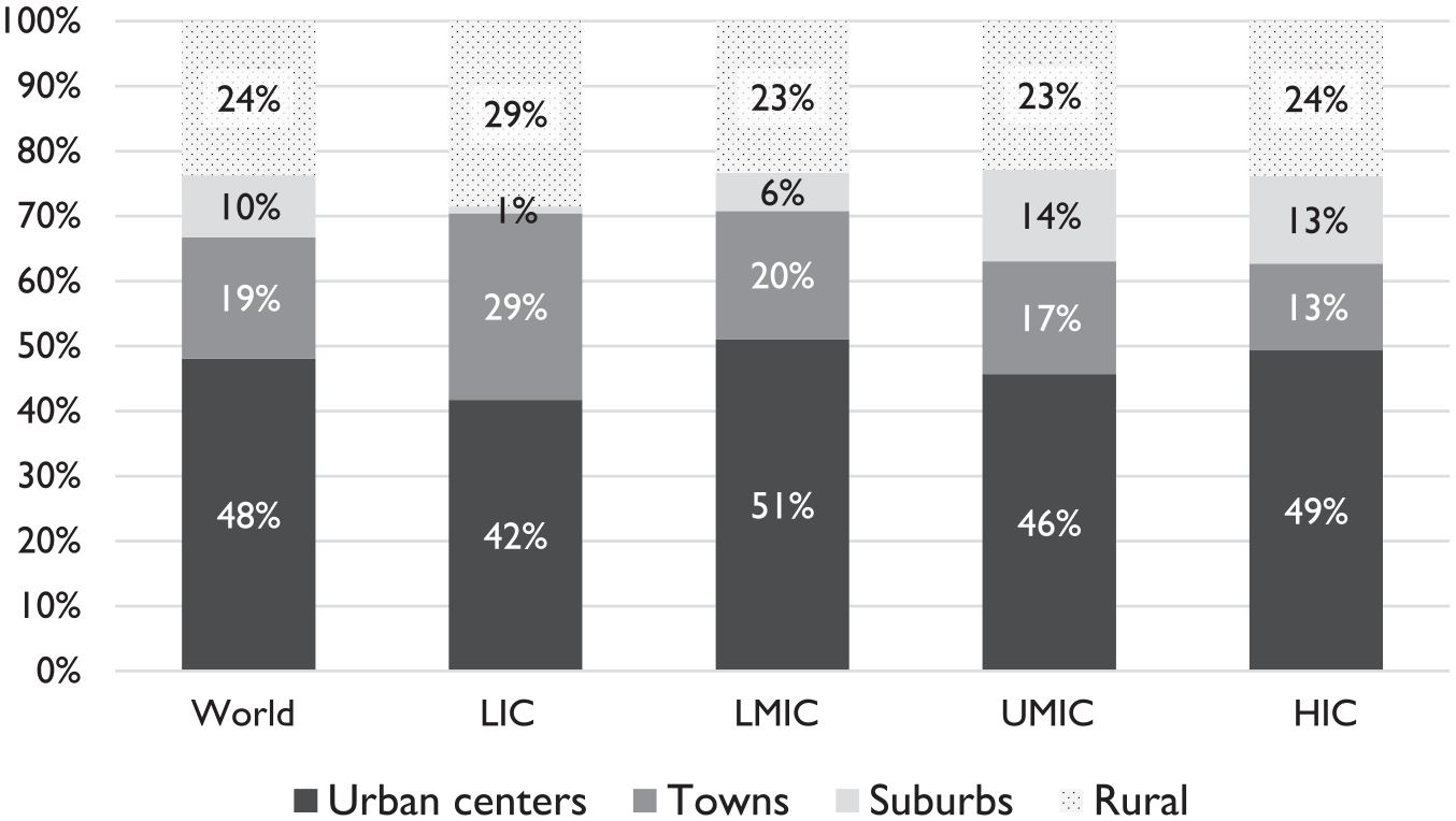
Distribution of total population by settlement type and income group, 2015.
As of 2015, towns hosted 29 percent, 20 percent, and 17 percent of the total populations of LICs, LMICs, and UMICs, respectively (Figure 1). In LMICs, which make up the bulk of the Global South, the population residing in towns is approximately the same as the population living in all million-plus cities combined. Whether towns would be classified as “urban” in national statistics depends on country-level definitions, and whether they are urban in the theoretical sense would, arguably, depend on the nature of their local economies (Potts 2018). Yet from a planning perspective, their size and density alone would necessitate some networked infrastructure and collective resource management (Qadeer 2000).
Figure 2 breaks down the population in urban centers by size, further underscoring the importance of smaller urban places in the Global South. As noted above, the literature frequently claims that urbanization in the Global South has resulted in greater concentrations of population in the largest cities than in the North (Henderson 2002; Sheppard 2014). However, of the GHS data call into question this perception. A similar proportion of the total population lives in megacities in LMICs, UMICs, and HICs. 6
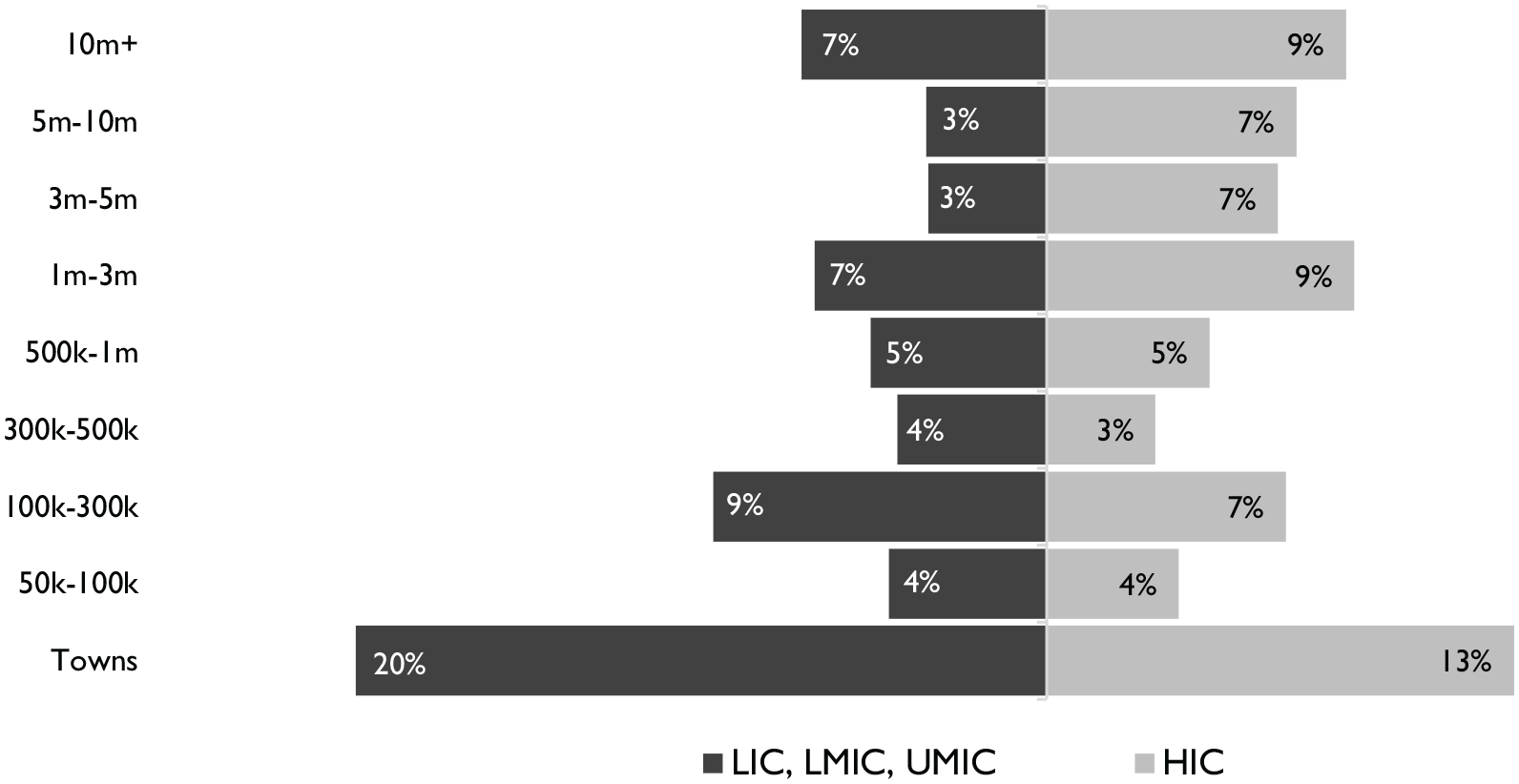
Share of total population across towns and urban centers (by size classes and income groups), 2015.
The difference between the Global North and South lies in where the urban population beyond megacities lives. Cities of one to ten million host 22 percent of the total population in the North, compared with only 13 percent in the South. Global South countries have a larger proportion of urban dwellers living in towns and small and medium-sized cities, meaning urban systems in the South are more “bottom-heavy” than in the North. Previous research, including the 2009 World Development Report (World Bank 2009), correctly identifies the lack of large secondary cities in many Global South countries, but neglects to see that this “missing middle” leads to demographic concentration in towns and small cities, not megacities.
2. The overall distribution of urban populations is relatively stable.
The GHS data provide empirical support for the theory that larger settlements are not growing faster than smaller ones, that is, a settlement’s size does not predict its rate of growth (Angel et al. 2016; Gibrat 1931). The correlation between a city’s size in 1975 and its growth rate over the 1975–2015 time period is close to zero 7 —indicating that there is no large-scale demographic shift in favor of the largest cities. This is particularly evident if we compare their share of population over time. The megacities of 2015 hosted 6 percent of the global population in 1975 and 7 percent in 2015, while the cities of one to ten million in 2015 grew from hosting 13 to 15 percent over the same period. Meanwhile, the total global population in towns alone grew more than the population in megacities. 8 Of course, there is significant variation at the country level. The Chinese megacities of 2015 hosted 3 percent of the country’s population in 1975 and 7 percent by 2015. In India, by contrast, the share of the national population in the megacities of 2015 has been almost static, changing from 6.13 to 6.16 percent between 1975 and 2015 (see Figure A1 in Supplemental Appendix).
Many studies examining urban systems over time reclassify cities from one size category to another as they grow (UN 2018). This exaggerates the change in urban systems, because much of the apparent shift is a result of all cities growing in population, rather than a redistribution of population in favor of the largest cities. Instead, Figure 3 shows change over time within unchanging cohorts of urban centers, defined based on their 2015 populations (e.g., an urban center that was a megacity by 2015 is placed in the megacity category from 1975 onward; similarly, a settlement that reached 50,000 inhabitants by 2015 is counted among urban centers from the beginning). 9 Using this method, Latin America & the Caribbean, the Middle East & North Africa, and Sub-Saharan Africa have seen falling shares of urban center population living in megacities. East Asia & the Pacific and South Asia have seen rising shares of their urban center populations in megacities, but only in the case of the first has the increase been impressive, with China as the principal driver.
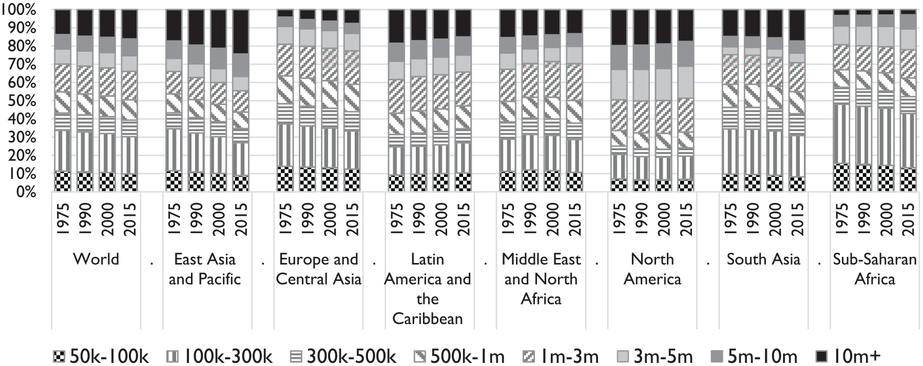
Distribution of urban center population by size classes and regions, 1975–2015 (unchanging cohorts based on 2015 population).
These findings suggest that, even as Global South countries urbanize more rapidly and under different conditions than did the North, they are retaining relatively stable urban systems. This aligns with scholarship on North America (e.g., Black and Henderson 1999), which shows that, while individual cities may gain and lose population in sometimes dramatic ways, the overall structure of urban systems remains relatively durable over time. China may be an exception, however; the state exerts powerful influence over the geography of urbanization and has in the past articulated a policy vision of concentrating people in megacities (Heikkila 2007; Henderson 2010).
3. The number of urban centers is expanding rapidly.
Because smaller urban places are growing nearly as fast as larger ones on average, an accelerating number are becoming “urban centers” by the GHS definition, based on population (>50,000 inhabitants) and density (>1,500 people/km2). Between 1975 and 2015, the global number of urban centers increased by 4,210—almost 4,000 of which were located in the Global South. While the GHS data do not indicate the degree of functional integration between these new centers and other cities, we do know based on the GHS methodology that they are spatially independent, rather than territorial outgrowths of existing cities.
Globally, the number of cities with between 50,000 and 100,000 people grew by 1,600, 1,443 of which were in the Global South, while the number with 100,000 to 300,000 people increased by more than 1,800, 1,710 of which were in the South. Meanwhile, the number of megacities, agglomerations of at least ten million people, grew by eighteen—from ten to twenty-eight (Figure 4)—with seventeen of these new additions in the Global South. Viewed through this lens, the challenge of planning for a large number of small places—as opposed to a small number of large places—comes into focus.
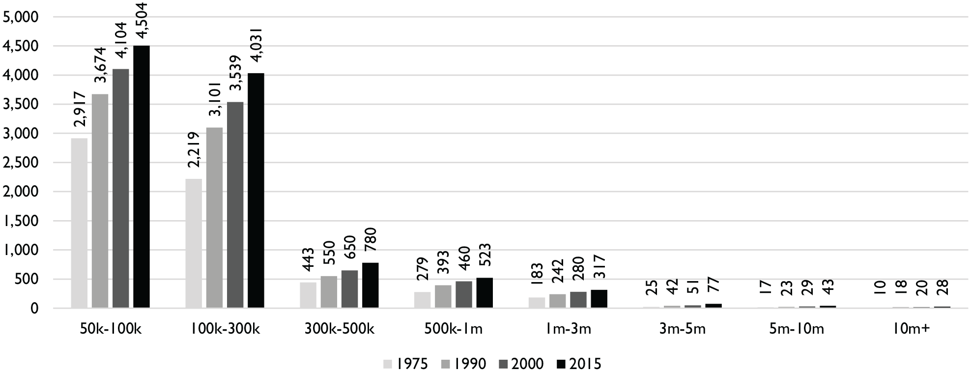
Number of urban centers by size category, world, 1975–2015.
In summary, as the South witnesses rapid urbanization, large shares of urban population are likely to be dispersed across a growing number of small urban areas. This phenomenon is unobservable in other datasets which only enumerate settlements of 100,000 or 300,000 people and above. It provokes the practical question of how to plan for a large number of small places, a question to which we turn next.
The Twenty-First-Century Urban Challenge: Planning for a Large Number of Small Places
As our analysis illustrates, one of the greatest challenges confronting planning in the twenty-first century is how to support inclusive urban development in the thousands of smaller urban areas emerging and growing across rapidly urbanizing countries. 10 This growth in the number of urban areas is occurring in countries with limited numbers of accredited planners. Cross-country research shows that many countries in Asia and Africa, such as India, Ghana, and Kenya, have fewer than one planner per 100,000 people—as compared with about thirteen per 100,000 in the United States and thirty-eight per 100,000 in the United Kingdom (African Planning Association & UN-HABITAT 2013). 11 While systematic evidence on the spatial distribution of planners within countries is sparse, the literature we outline above indicates that small cities within these countries are especially likely to face severe capacity constraints.
Small urban centers emerging across the South also face the potential of being left behind economically. Theory and evidence would suggest that Global South megacities are likely concentrating wealth more than they are concentrating people. Trade liberalization has had strong polarizing effects in the Global South, exacerbating inter-regional inequalities within countries (Milanovic 2005; Rodríguez-Pose 2012). On top of this, most of the South is starting to witness its own shift from manufacturing- to services-oriented growth (Rodrik 2016). As we know from extensive evidence in the Global North, this structural shift favors the biggest cities in terms of economic growth, as high-paying, tradable services tend to cluster in “superstar cities” (Florida 2017; Kemeny and Storper 2012; Moretti 2012). If the same trends are observed in the South, then planners will need to devise strategies for small urban centers that are resource-poor when compared with Southern megacities.
One might argue that planning still ought to focus research and practice in megacities in the South, given that the field has relatively little knowledge of how to plan for metropolitan regions of their unprecedented size. However, even if the field has a longer history of planning in cities of, for example, 100,000 people, planning for hundreds of such places that are emerging simultaneously is, in fact, an unprecedented challenge; and, as noted, the economic context in which these new urban centers are burgeoning may itself present issues that planning has not fully grasped. Regardless, our appeal is not for planning to limit the attention paid to megacities, but rather for scholars and policymakers to adopt a wide enough lens to see that another set of challenges, beyond the metropolis, looms large as well.
Reviving the Concept of “Barefoot Planning”
As the previous section and our literature review make evident, planning must face the significant challenge of shaping urban growth in a large number of small urban places where professional planning capacities are limited. While meeting this challenge will require a range of actions across many domains—political, institutional, and economic—our field must consider what it means for planning education and practice. “Barefoot planning” is an adaptable framework capable of extending the reach of planning principles in rapidly expanding urban systems. As we describe below, the term “barefoot planning” has been used in various ways. We define it as an approach that seeks to bridge grassroots engagement and technical planning expertise by training a cohort of community members to play certain roles generally reserved for professional planners.
The notion of “barefoot” professionals draws inspiration from China’s “barefoot doctors,” rural citizens who were given basic medical training soon after the Communist revolution to cater to the day-to-day health care needs of their communities (World Health Organization 2008). The idea of barefoot professionals caught on internationally and across professions, including in planning. At a 1980 conference of the International Society of City and Regional Planners (ISoCaRP) in Tunis, the organization’s vice president, Percy Johnson-Marshall, made the case for the barefoot planner as “a kind of environmental caretaker” responsible for “bridging the gap between the specialist and generalist” (Dix 1980, 446). The United Nations Center for Human Settlements (UN-Habitat) took considerable interest in the need for local training related to human settlements in the Global South, holding meetings and commissioning research on the topic in the mid-1980s (Oberlander 1987). A comprehensive report by H. Peter Oberlander of the University of British Columbia’s Centre for Human Settlements outlined the need for barefoot planners and proposed guidelines for future training efforts (Oberlander 1987).
Oberlander’s report includes a desk survey of fifteen institutes and three projects in Africa, Asia, and Latin America that provided some form of training in the management of human settlements in the 1980s. Perhaps the most prominent application of the barefoot planning concept, also during the 1980s, was in Mozambique, where the national government and UN trained barefoot planners to help design and implement sites-and-services projects (Burdett and Taylor 2011; Lamba 1985; “Training Barefoot Planners” 1983). However, for reasons that are unclear and warrant further investigation, the concept appears to have lost currency after the 1980s. It has reappeared only occasionally in the urban planning and development literatures (Martin and Mathema 2010; Wamsler 2007; Wang 2015; Zinn, Lyons, and Hinojosa 1993), and does not appear to have been implemented at scale in recent decades. 12
What roles could barefoot planners assume in smaller urban settlements of today’s rapidly urbanizing countries? First, they could undertake the task of collecting and maintaining community data on a fine-grained spatial and temporal scale—particularly on built environment and land use issues with poor coverage in traditional government surveys—to supply evidence in local planning processes. Second, barefoot planners could initiate and facilitate public participation processes to gather information on planning-related issues and solicit community input on decisions that affect the growth and management of their towns and cities. Finally, they could use both sources of information to advise leaders in village, town, and municipal governments on planning-related decisions. They could act as liaisons to government agencies, representing community interests in the development of plans or the implementation of major infrastructure projects. 13
The technical expertise of barefoot planners could be developed through courses focused on skills such as organizing community consultations, gathering spatial and demographic data, drawing maps, and interpreting spatial plans. Such training could be provided to individuals within community-based organizations that already play an active role in guiding the growth and management of their communities. Training could also integrate instruction on issues of equity, inclusion, and sustainability, enabling these core tenets of planning to reach deeper into the network of human settlements than they do currently.
A revival of the barefoot planning approach could help meet the challenge of planning for a large number of small urban places. With such tremendous growth in the number of urban settlements in many regions of the Global South, an expansion of planning programs in universities must be complemented by other impactful solutions aimed at extending the reach of planning education. It would be impractical to suggest that planning capacity gaps in rapidly urbanizing countries can be filled entirely by professional planners, as this would require an unfeasibly swift expansion of university-level planning education. The logic of the barefoot planning approach is to grow professional planning capacities through enhancing and formalizing community-based actions. In his report, Oberlander (1987, 4) argues that “training programs which focus on ways and means of complementing and supporting local initiative can act as a catalyst through which local groups are assisted in articulating their needs and priorities, and thereby implementing concrete solutions within scarce resources.”
For several reasons, barefoot planning is particularly relevant for small and emerging urban settlements of rapidly urbanizing countries. First, as our literature review shows, these are the urban environments where supplements to professional planning capacity are most acutely needed, as they are the most neglected urban areas within countries that already face national shortages of planners. Second, the potential range of appropriate roles for a barefoot planner in these urban settlements is likely to be greater than in a large city, where decisions around metropolitan-wide issues such as land use, transportation, and economic development require coordination among many different institutions and across many layers of bureaucracy.
Finally, ordinary citizens, private entrepreneurs, and community-based organizations, while they shape cities everywhere, are especially involved in directing the evolution of smaller cities (Irazábal and Neville 2007; Miraftab 2009; Miraftab and Wills 2005; Mitlin 2008; Patel, Arputham, and Bartlett 2016; Sandercock 1998). Enabled by what Cook (2018) calls the “dense intimacy” of relationships in smaller cities of the Global South, this capacity and local expertise, residing in groups not conventionally considered “planners,” represent an asset to be harnessed, according to the barefoot planning approach (Oberlander 1987). Yet relying purely on local knowledge and leadership can reinforce existing inequalities or lead to elite capture, an issue of concern in small cities, as our literature review notes. Training programs originating from beyond the local community under a barefoot planning framework can empower particular community members to advocate for inclusion, sustainability, and consensus-building, helping to counter this threat.
These considerations suggest that barefoot planning is particularly applicable to the challenges at hand, namely, those arising from the proliferation and growth of small urban settlements in the South. However, the concept of training community leaders in planning-related skills may also have broader resonance. Barefoot planners could be impactful in addressing neighborhood-level issues in the informal settlements of large cities of the urban South or neighborhoods of poverty and exclusion in the urban North—that is, wherever communities require a stronger voice in the formal planning regime.
Moreover, city size is not the only relevant variable in judging the appropriateness of the barefoot planning approach in a given geography. Clearly, social, political, cultural, and economic factors would influence the applicability and nature of barefoot planning across different contexts. In some countries, the relevance of barefoot planning may be circumscribed by highly centralized decision-making processes. Even different jurisdictions within the same country may require different implementation strategies. For example, many areas designated as “urban” by the Indian census are still administered as rural. Barefoot planners in these contexts could influence many planning decisions through direct coordination with village-level authorities, who have high levels of autonomy, whereas barefoot planners in similar settlements administered as municipalities would have to interface with multiple levels of government (Samanta 2014). The nature of barefoot planning would also be deeply influenced by histories of governance. For example, Indonesia hosts well-established, uniform systems of representative government down to very small administrative units (the rukun tetangga, or RT, usually contains about thirty households; Bebbington et al. 2006). Barefoot planning in this context may require close integration with participation models already established within these governance structures. In many African contexts, barefoot planners would need to work with traditional authorities who govern customary land (Owusu-Ansah and Braimah 2013). However, these context-specific factors should not preclude planners from proposing and debating general frameworks, as planning scholars have previously argued (Hinojosa, Lyons, and Zinn 1992).
Barefoot planning, as we describe it, has never been implemented on a major scale, nor have past efforts been well documented. Based on Oberlander’s (1987) report, most previous training programs for barefoot planners were evaluated in terms of their impact on individual trainees as opposed to their impact on communities. Robust monitoring and evaluation frameworks, aimed at understanding programmatic impacts on settlements and planning processes, would be needed for future initiatives to promote swift learning and adaptation. Further research should also investigate whether the apparent lack of focus on barefoot planning and related concepts since their initial promotion in the 1980s reflects a reconsideration of their effectiveness, a change in academic trends or internal priorities at development institutions, or simply a change in terminology or positioning (e.g., similar activities may now be included as components of broader “capacity building” programs). Future researchers and practitioners could also update Oberlander’s (1987) guide with consideration given to the planning contexts of the twenty-first century, especially because advancements in technology may render particular roles more accessible to barefoot planners than they were three decades ago.
Conclusion
Many representations of contemporary urbanization create the impression that people are concentrating in the largest cities, especially in the Global South. However, our analysis of new data has shown that the structure of urban systems around the world remains relatively stable and that urban populations in the South are more “bottom-heavy”—that is, concentrated in towns and small cities—than in the Global North. In rapidly urbanizing countries, the proliferation and growth of new urban areas represent an important but generally overlooked development of the last four decades. While we have discussed some implications of this trend for planning, we hope future scholarship will deepen our understanding of how the planning community in various national contexts is grappling with expansion at the bottom of the urban hierarchy. For example, better data on the distribution of planning resources across smaller urban areas, and a sharper understanding of who plans small cities, would greatly enhance our understanding of the opportunities and challenges local governments face in managing urban growth.
Barefoot planning is a way of integrating citizen and civil society knowledge and action in emerging urban areas with professional planning expertise, toward shaping inclusive urban futures. It is one possible approach for ensuring that core planning principles are embedded in the global urban transition. However, our findings should prompt further dialogue and research among planning scholars and educators around how to plan for the spectacular expansion of the global urban system.
Supplemental Material
JPER971705_Appendix_-_Planning_for_a_Large_Number_of_Small_Places_Randolph_Deuskar – Supplemental material for Urbanization beyond the Metropolis: Planning for a Large Number of Small Places in the Global South
Supplemental material, JPER971705_Appendix_-_Planning_for_a_Large_Number_of_Small_Places_Randolph_Deuskar for Urbanization beyond the Metropolis: Planning for a Large Number of Small Places in the Global South by Gregory F. Randolph and Chandan Deuskar in Journal of Planning Education and Research
Footnotes
Acknowledgements
The authors would like to thank Lewis Dijkstra and Martino Pesaresi of the European Commission for providing supplemental data and answering questions regarding the construction of the Global Human Settlements database. We are thankful to Lisa Schweitzer for offering substantive comments on an earlier version of this manuscript. Finally, the journal editor and five anonymous reviewers provided valuable feedback on the manuscript during the review process.
Declaration of Conflicting Interests
The author(s) declared no potential conflicts of interest with respect to the research, authorship, and/or publication of this article.
Funding
The author(s) received no financial support for the research, authorship, and/or publication of this article.
Supplemental Material
Supplemental material for this article is available online.
Notes
Author Biographies
References
Supplementary Material
Please find the following supplemental material available below.
For Open Access articles published under a Creative Commons License, all supplemental material carries the same license as the article it is associated with.
For non-Open Access articles published, all supplemental material carries a non-exclusive license, and permission requests for re-use of supplemental material or any part of supplemental material shall be sent directly to the copyright owner as specified in the copyright notice associated with the article.